Suburban Transit-Oriented Development
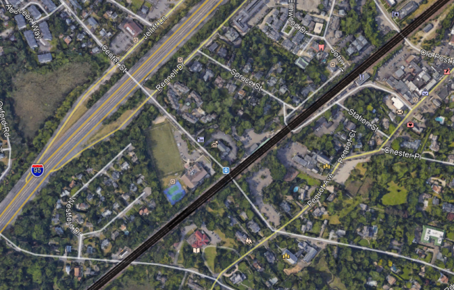
Here’s a Google Maps image of Southport, a section of Fairfield, Connecticut with its own Metro-North commuter rail station:
Here’s an image at the same scale of Bourg-la-Reine, an inner suburb of Paris on the RER B, at the junction between the line’s two southern branches:
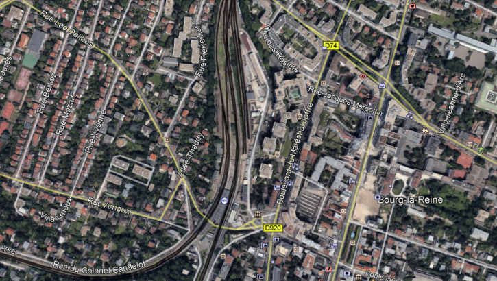
At Bourg-la-Reine, the buildings just east of the station are high-rise. There are local community amenities, including walkable schools, supermarkets, and pharmacies, and people can comfortably live in this suburb without a car. This generates significant RER traffic at all hours of day: outbound trains are often standing-room only until they reach this station even in midday, outside rush hour.
At Southport, there are a few townhouses near the station. But the roads are wide and hostile to pedestrians, and the nearest supermarket closes at 6 pm, too late for commuters returning from the city. Car ownership approaches 100%, and nobody rides the trains except to get to office jobs at the traditional peak hour in Manhattan (or perhaps Stamford).
The difference between the two places is so stark that they can barely be compared. Southport has 317 inbound boardings per weekday. Of those, 263, or 83%, are in the morning rush hour; the Metro-North-wide average is 63%, and the average on the SNCF-operated parts of the RER and Transilien is about 46%. Bourg-la-Reine has 4.5 million annual riders, about 16,000 on an ordinary working day.
A huge part of the difference is about service provision – Bourg-la-Reine has a train every five minutes midday, Southport a train every hour. But it’s not just about service. The RER has stations farther out, with somewhat less intense service, such as a train every 15 minutes, with comparable ridership. And the LIRR and Metro-North have little off-peak ridership even at stations with more frequent service, such as Mineola and Hicksville. Transit-oriented development (TOD) is as important as good service in such cases.
I bring up Southport because the RPA just dropped a study about suburban TOD that grades every New York commuter rail station between 0 and 3, and gives Southport the highest mark, 3. The RPA study looks at zoning within 800 meters of each station and considers whether there’s a parcel of land that permits multifamily housing with a floor are ratio higher than 1.25. Southport has such lots, supporting some townhouses, so according to the RPA it gets full marks, even though, by RER standards, it is like every other American car-oriented suburb.
Based on this methodology, the RPA identifies a number of good suburbs, and even comes to policy conclusions. It proposes more TOD in the mold of existing exurban New York examples, such as Patchogue. The model for the program is the real reason the RPA study is so weak: rather than calling into attention the big differences between land use at suburban stations in New York versus in Paris (or any number of big European cities with suburban rapid transit), it overfocuses on small differences within auto-oriented suburbia.
Some of the ultimate conclusions are not terrible. For example, the RPA is proposing linking federal infrastructure development to permitting more multifamily housing. This would improve things. However, the problem with this is twofold. First, it is unrealistic – the federal government gave up decades ago on enforcing fair housing laws, and has no interest in attempting to make exclusionary suburbs behave. Were I to propose this, hordes of American commenters would yell at me for not understanding American politics. And second, it misunderstands the nature of the problem, and ends up proposing something that, while unrealistic, is still low-impact.
The best way to understand the problem with the study is what author Moses Gates told me on Twitter when I started attacking it. He said that the RPA was looking at zoning rather than actual development. Since there is zoning permitting multifamily development within the prescribed radius at Southport, it gets full marks. With my understanding of what good TOD looks like, I would be able to say that this is clearly so bad the methodology must be changed; on Twitter I suggested looking at zoning within 300 meters of the station rather than 800, since the highest-intensity development should be right next to the station. I also suggested looking at supportive nonresidential uses, especially supermarkets. A development that isn’t walkable to retail at reasonable hours is not TOD.
The RPA does not think in this language. It thinks in terms of internal differences within the US. Occasionally it deigns to learn from London, but London’s suburban development is auto-oriented by European standards (transit mode share in the London commuter belt is at best in the teens, often in the single digits). Learning from anywhere else in the world, especially places that don’t speak English, is too difficult. This means that the RPA could not reach the correct conclusion, namely, that there is no such thing as an American suburb with TOD. The only exception I can come up with in the United States involves Arlington, on the Washington Metro, and Arlington is no longer considered a suburb, but really a full-fledged city in a different state, like Jersey City.
The other thing the RPA missed is that it drew too large a radius. TOD at a train station should include townhouses 800 meters out – but it’s more important to include high-rise residential construction next to the train station and mid-rise apartment buildings 500 meters out. Giving American suburbs latitude to place TOD so far from the station means they will act like Southport and allow small amounts of multifamily housing out of the way, while surrounding the station itself with parking, a tennis court, and large single-family houses with private swimming pools. This is not hypothetical: suburbs in New Jersey have reacted to court rulings mandating affordable housing by permitting apartments at the edge of town, far from supporting retail and jobs, and keeping the town core single-family.
Because the RPA missed the vast differences in outcomes between the US and France, it missed some useful lessons:
- States should centralize land use decisionmaking rather than give every small suburb full autonomy.
- TOD doesn’t need to be fully mixed-use, but there should be some local retail right next to housing.
- Housing should be high-density right next to the station. A floor area ratio of 1.25 is not enough.
- Publicly-funded social housing should be next to train stations, in the city as well as in the suburbs, and this is especially important in expensive suburbs, which aren’t building enough affordable housing.
Without suburban TOD, any regional rail system is incomplete. I wish I could have covered it at my talk, but I didn’t have time. Good service needs to run to dense suburbs, or at least suburbs with dense development within walking distance of the station. It needs to extend the transit city deep into suburbia, rather than using peak-only commuter rail to extend the auto-oriented suburbs into the city.

Thanks, Alon, for this.
The Ballston-Rosslyn Corridor still sucks, though, in that if you go 2500m circumferentially, you’re nowhere near a rail station. When I was working in DC proper, many of my ex-coworkers said moving from the Ballston-Rosslyn Corridor to DC proper (Dupont, Adams Morgan, Mount Pleasant, U St, etc.) was the best move they made. Ballston just sucked to them.
I’d argue it’s easier to live without a car in Cambridge, Somerville, and parts of Brookline than on the Ballston/Rosslyn Corridor because of groceries (though there is a Trader Joe’s in Clarendon). The nearby areas surrounding the MBTA’s Green Line inbound of Cleveland Circle and in Cambridge/Somerville are more walkable than the areas surrounding the Ballston/Rosslyn Corridor.
I really wouldn’t call Cambridge and Somerville suburbs. Technically they’re separate cities, but they’re both denser than Boston proper, and Cambridge even has a higher jobs-to-employed-residents ratio than Boston. There’s also no real psychological difference between them and Boston the way there is between Paris intra muros and the banlieues (or between New York and Jersey City).
Since when is Southport, CT, an inner suburb? As the crow flies, the Southport train station is about 45 miles from Times Square, while the “exurban” Patchogue, NY train station is about 50 miles. The comparison between Southport and an inner suburb like Bourg-la-Reine is pretty unfair.
I zoom in on Southport because it got a 3 on TOD. But if you want to see suburbs farther out of Paris than Bourg-la-Reine, here’s Massy:
If you want to go farther out than Massy, then major examples include Marne-la-Vallee, Melun, Meaux, and Mantes-la-Jolie.
MTA website says that no buses serve Southport station, and there isn’t even a sidewalk (as far as I can tell from Google Street View) from the station to the town’s CBD (small as it is).
Though Google Maps will “let” you walk on the road to the station, so perhaps Station Rd is actually a woonerf! 🙂
It’s sad this is in greater NYC, the most urban part of the nation. It’s pretty terrible here in the Bay Area, where almost no Caltrain commuter rail stop is walking distance to anything useful.
Sort of tangential, but who decided to put Southport’s two platforms 100m apart? Looks lovely to walk between the two sides too
The odd offset between platforms will close up a bit when Southport gets funded for platform extensions to 10 cars. They’re currently very substandard 4-car platforms, so they will converge towards the Station St. overpass when the lengths are more than doubled to current New Haven Line spec. Overpass would likely get replaced in a package with that allowing for safe sidewalks underneath and–at last–a non-convoluted and accessible walking transfer to opposing platforms. Lots of small bridges in the vicinity have been rapid-replaced during the constant-tension catenary installations, but this one was left alone for now because funding sources would be better drawn from a station renewal pot.
Southport’s not been earmarked for renovation yet because there’s still 3 platforms west of Stamford (Cos Cob, Riverside, Old Greenwich) higher on the pecking order for 10-car capacity expansion because those see the densest schedules and all have ADA deficiencies on their egresses that need correcting ASAP. Then Rowayton (6 cars, similar ADA issues) is next-up on the priority pile for settling up the next-densest schedule segment through South Norwalk with 10-car boarding and full ADA compliance. Penn Station Access flooding Stamford with more local schedules and the expansion order of 60 (expandable to 94) M8 cars is putting a giddayup on ConnDOT to fund the 3 stations west of Stamford for design within 5 fiscal years, so it won’t be an interminable wait before Southport breaks into the priority top-tier for renovations. But first things first on the pecking order.
Sure, I don’t doubt that there are much higher priorities for what to fix, it just seems like a strange design decision in the first place.
Joey, both platforms have station houses that are more than 100 years old. This leads me to believe that the design decision was made by the original builders of the New Haven Line back in 1849. I’m sure someone could find the answer to your question, but it would involve some serious archival research because it happened so long ago.
“States should centralize land use decisionmaking rather than give every small suburb full autonomy.”
It would be very difficult for US people to accept this. (At least, in a productive way.)
“Publicly-funded social housing should be next to train stations, in the city as well as in the suburbs, and this is especially important in expensive suburbs, which aren’t building enough affordable housing.”
I see the social value in this, but be aware that by suggesting it you are making powerful enemies for TOD wherever it is suggested, and you are likely to sink the TOD project entirely.
Somehow, Americans managed to accept all manners of federal and state intrusions on sacred local autonomy (Common Core!).
And the expensive suburbs aren’t going to want any kind of TOD. You propose condo towers for tech workers in Silicon Valley and they still complain.
I think the Republicans against the nanny state, and NIMBYs against anything, will together form an unbeatable coalition.
Republicans are against the nanny state for rich white old straight guys. Everybody else can be micro managed. . . most Republicans wandered off to spend more time with the family and going to the country club. The then Dixiecrats took over.
Common Core was an agreement between states that the right up in arms about. And states joined the agreement then left of only accepted the English language parts but not the mathematics. Or was it the reverse.
In terms of suburban TOD, I reckon that Sydney has pretty good examples (within the relatively car-dependent USA-Canada-Australia context). I mean, it’s not good in NY as you described. In Toronto, suburban TOD is non-existent despite pretty good suburban residential density which results in high-density car dependency. Vancouver has been rapidly improving but it’s mainly a lot of residential TOD and still could do a lot better.
One problem with TOD in Sydney is that residential density is still low compared to Canadian cities (but still higher than other Aus cities) but what Sydney does better the other car-dependent trio is in putting destinations near transit like retail and offices (almost like your Paris example). This is probably why I suspect Sydney has a JTW of almost 27% (2016 Census), in-line with Canadian cities despite a lower residential density than them. Just as some shopping examples, all deep in suburbia, notice where the shopping malls are in relations to rail.
https://www.google.com.au/maps/@-33.7038361,151.1002258,623m/data=!3m1!1e3
https://www.google.com.au/maps/@-33.7707868,150.9071008,785m/data=!3m1!1e3
https://www.google.com.au/maps/@-34.0351537,151.0997386,823m/data=!3m1!1e3
https://www.google.com.au/maps/@-34.0751544,150.7932994,1451m/data=!3m1!1e3
And here’s the metro line I was fighting with Micheal about.
https://www.google.com.au/maps/@-33.6914976,150.924202,3a,90y,355.28h,91.3t/data=!3m6!1e1!3m4!1syGuheQBgzUaN3y6y4SDKIA!2e0!7i13312!8i6656
The residential side of TOD is pretty weak in Sydney, but the destination side of TOD seems to be pretty strong (although certain could still be improved) in Sydney compared to similar cities and can probably be used by other English speaking cities.
Relevant that I found recently on internet: http://www.spur.org/publications/urbanist-article/2016-07-07/can-state-power-make-better-region
Wait, which Canadian cities have 27% transit mode share? As of the 2011 census, the highest in Canada is 23% in Toronto.
Well the two cities had similar mode shares in 2011 so I’m assuming that Toronto may do just as well in 2016 and other Canadian cities have mode shares around that range. Still have to wait for Toronto census but looking at the news, it doesn’t seem to be doing too well. https://pbs.twimg.com/media/DMyPHVHVAAELeuk.jpg
While I’m here can I just say that Toronto still doing suburban density pretty badly. Just look at the new Downtown Markham project. It’s very close to Unionville station so it should be a TOD but it’s very badly designed. The main part of the Downtown Markham where all the shops are is a long walk from the train station and you’ll need to get a bus to access the shops, the walk is more pedestrian friendly than normal suburbs but it’s length is too long. I know Unionville station only has rush hour trains but that’s going to change soon.
Okay, so the data for census Canadian cities have just come out and Toronto has a mode share of 24.3%, the highest in Canada. Australia’s data got pulled because it was kind of inaccurate and has just been re-released and Sydney’s mode share is bang on 27%.
http://www12.statcan.gc.ca/census-recensement/2016/as-sa/98-200-x/2016029/98-200-x2016029-eng.cfm
In contrast, NYC metro area mode share is 32%.
https://www.thetransportpolitic.com/databook/travel-mode-shares-in-the-u-s/
It’s also kind of interesting that the drop off in Canada is gradual from Toronto’s 24% to other cities where as in Australia, it’s Sydney with 27% and then other cities is in the teens. A bigger drop off, a bit like the US.
I was slightly surprised Vancouver was flat (20.4%, up from 19.7% in 2011) – there was a noticeable increase in ridership from 2014 to 2016. But the Evergreen Line only opened after the census, so it should be up more by 2021, and up by a lot more once the Broadway subway opens.
The mode share is 32% in the New York Metropolitan Statistical Area, which omits a lot of suburbs, including all Connecticut suburbs. The larger Combined Statistical Area corresponds better to the extent of the city’s commuter rail system, and there the mode share is just 29%.
There are almost as many people in New York’s CSA as there are in Australia. All of metro Sydney could move to Brooklyn and Queens. Or all of British Columbia could. With space leftover. All of metro Vancouver could move to Brooklyn. Or Queens, take your pick. You are comparing apples to watermelons
The source you linked to that states a 32% transit share for New York states that it is for the New York Urbanized Area; “Urbanized Area” is yet another spatial definition by the US Census Bureau that is different and unique from the MSA and CSA definitions. You should be a little more careful with the “Urbanized Area” definition to avoid comparing “apples with watermelons”
But what exactly are you guys trying to “prove” here with these figures?
That Sydney at 27%, or Toronto at 24%, are not much different to NYC at 32%?
NY city (5 boroughs) has 56% public transport mode share for a city of about 8.5 million which is twice the Sydney total. But of course that is still inadequate because those 8.5m New Yorkers are in an area of about 800km2 while the Sydneysiders are sprawled across more than 12,000km2. The NY Metro Area may be something similar to Sydney (this is a point of contention very dependent on how one measures it) but a much higher percentage of the total has much higher PT modal share.
What one really needs is data on mode share at distance from the centre, and/or radial bands of equal population. I am pretty sure this would “prove” the obvious: that all cities would show a drop-off as you reached suburbs (or New York City limits & periphery and adjoining cities). But the population data would show far higher percentage of commuters in NY, both NYC and Metro Area, use PT than in these other cities. Which just proves what we all know: it is more difficult to deliver PT to low-density sprawl the further it gets from a city centre. In turn this “proves” that the main way in which these other cities (Sydney, Toronto) can improve their PT mode share is by densifying their more inner areas and perhaps building higher-density TOD in their outer reaches too.
Not trying to prove anything! Just an interesting comparison of and observations on information that just came out from CAN and AUS. The fact that NY Metro has a dense inner city doesn’t excuse the suburbs, a lot of which are even worse than LA (which takes us back to the original purpose of the post). Anything else you want to know? Also, the real urban area of Sydney is much smaller than 12,000km2 used for statistical purposes by the census. It’s more like 2,000km2, which is massive but it is smaller than Melbourne’s 2500km2 and, believe it or not, similar to your own Brisbane’s 1900km2. (Demographia World Urban Areas)
There is a huge difference between bus use in the London suburbs, inside London’s borders and those outside. Thanks to the botrders of London expanding in the 1960’s the big suburbs all came under London’s control. Outside there the rest of London’s commuter belt is surrounded by a green belt, now up to 30 miles wide.
This has kept many towns quite small near London, while pushing large scale suburban development even further to either new towns or approved expanded towns.
The theory was the great beast of London would be tamed and decongested by depopulation and all these new towns would become self sufficient in jobs and few people would commute. Did not work out that way, Now huge numbers of people commute to London on long distance commuter trains.
Most of London’s commuter towns have a quite frequent all day service, that only really starts to fall off after 10pm. Great for getting to London or larger towns on the main lines, but travelling around said towns depends on expensive commercial bus services or no or almost no bus services in small towns and villages that have a half hourly train to London 40 miles away but only a car park at the station and if you are lucky to afford it a house within walking distance of that station.
Thinking of my own home town near London only 5 miles from the London border, it was once a major manufacturing area but is now stuffed full of offices and distribution centres etc. While it is poorer than the Gin and Jaguar belt that surrounds this part of London it’s still a pretty succesful town as far as wages go. It has four stations to London serving it’s 140,000 population with the main station acting as a major interchange on the main line now surrounded by rising high rise apartments and offices after years of stalled regeneration projects. Me nearest station has three small trading parks near the railway and canal, while to South is dense UK suburbs , with a local shopping paeade or two schools and a college. But the bus service. Most routes are half hourly and there are some routes that link neighbouring towns, but they don’t go link too many. Though it does not help that in most directions the area is littered with small towns of 5 to 10 thousand all near each other. The bus fares are distance based rise rapidly with distance. The bus only becomes affordable if you buy a monthly pass or you are deeply subsidized like the old age pensioners. The few times I’ve used the bus, when my car is being serviced is that nearly all the passengers are over 60 or are care in the community. It only changes at rush hour. It’s bizarre really I whip into London anytime I want, there is even all night service to the main station if I need it. As long as my destination is near a train station then getting to another town along the main line can be done with dozens of other towns for some quite long distances depending where I interchange, as long as those towns are on the correct lines. If they are one or two valleys over, than are well the might as well be 100 miles away. As for getting around different towns it all depends on their size and accidents of geography. You have to go to big cities where the number of travellors keeps prices down.
Speaking as someone else not that far outside London, I concur. I think Alon is making London seem far more car centric than it actually is.
I believe the Americans have a different definition of suburbs to us Brits – to do with politics rather than actual urbanity, so the interwar, Metroland-style railway-centred suburbs mostly don’t count as they are inside Greater London. If you look at maps from when places in ~zones 4-6 started developing, it was from the railways they grew, not the new arterial roads. London itself has the worst network of roads of any city in the developed world, and the commuter belt locations are almost all as bad.
My town was mostly built between the 1930s and the 1960s, with walking to the railway station a key part of the developments of that period, with lots of footpaths aiding that. However, while having a large number of people using that service (over 5,000/day on average) we’re not in the London Travel to Work area, so London isn’t our main place of employment and so proportionately few journeys use the station.
We do have buses up to every 15 minutes to our nearest big town, but they are normally relatively empty as the bus costs about £6 for a return and thus is more expensive than the car as well as at least 50% slower town centre-town centre. Other big towns (and we’re talking about about 4 in total 100k+ population all about 8-13 miles away – big and not that far) in the area might get a bus every hour or typically every two hours and take a while and be expensive. The second-nearest big town, and the main shopping location for the area has hourly buses that take 40 minutes to do 12 miles. If one is able-bodied like I am, one can get the train to the junction station, change, get the train out on a different branch and then walk 2 miles and do the journey in the about the same time as the bus for £1.50 rather than £5 single. Or I could drive and spend about £2 each way, £3 for 3 hours parking (closer to the shops than the bus stop) and not only save nearly an hour total travel time vs taking the bus but pay the same price as well. Additionally, travel around the town is pretty bad by public transport – it’s mostly walk, cycle (though there’s few facilities for that), car or taxi. Buses will take you between a couple of locations in a way that can attract more than maybe 1 or 2 passengers per stop per bus.
Car gets a high modal share around London (less so inside) not because we build stuff around the car – if anything we actively seek to make stuff not great for the car, but because the alternatives – except for going to the places served by the railway the places are built to serve – are terrible.
There are other examples in Northern Virginia besides Arlington which have seen significant TOD, especially in recent years, like Dunn Loring, but as you mention they’re all on Metro so it’s not quite the comparison you’re looking for. For examples of real American commuter rail suburbs I would suggest you look at Chicago.
Some major suburbs of Chicago, like Evanston or Oak Park, are also served by the L rather than just commuter rail, and are almost contiguous with the city proper, so that’s not quite the same as a true commuter rail suburb; Joliet and Aurora would also be excluded by your measure since they were already small cities in their own right before the area between them and Chicago filled in.
Arlington Heights is one example I am quite familiar with. It was always a railroad suburb of Chicago from the very beginning, but it does have a significant amount of modern TOD, mostly from the 1980s on. This includes a few high rises, numerous mid-rises, and a retail district – extending to about a 300m radius from the station. Its ridership, approximately 2500 boardings per weekday, puts it fourth among all of Metra’s outlying stations. While this is about an order of magnitude below what you might see in a Parisian suburb, it is nevertheless pretty good for the US, and is also notable because there’s not enough parking near the station to accommodate that many riders, so many of them have to be walk-ups. Park-and-riders are accommodated at the next station out, Arlington Park.
Ridership and schedules are both heavily biased towards the peak period in the peak directon, with trains departing every 15 minutes. Reverse-peak and mid-day service is bad, with gaps up to 2 hours; bus service to and from the station is also so bad as to be completely irrelevant. The area around the train station would definitely be more appealing, and I predict ridership would increase correspondingly, if all-day service patterns and useful bus connections were implemented. This is on a three-track line with only moderate freight traffic, so increasing service SHOULD be possible. Terminal capacity may be a limiting factor at rush hour, but certainly half-hour midday frequency should be achievable.
One thing I would unfortunately say you are never likely to see in the US is for wide swathes of single family neighborhoods to be upzoned to (for example) double their residential density, or include commercial entitlements. There is a peculiar but broadly held conviction within the US, across the political and economic spectrum, that the single-family neighborhood is somehow ‘virtuous.’ Attempting to counter this conviction is politically fraught and is essentially a nonstarter. Single blocks within SFH neighborhoods do occasionally get picked off, in a grassroots manner, when all the owners in the block band together to support an upzoning and sell to a developer at the same time – but that’s about it.
The best areas to target for TOD upzoning would be the massive parking lots owned by the commuter rail agencies right next to stations. Places like the Route 59 and Naperville stations (#1 and #2 respectively for Metra’s outlying stations) would seem to be ideal targets for this strategy. Other areas that could be targeted for upzoning will by necessity have to be restricted to industrial areas and existing commercial districts.
I think SC (comment above) might have a point. Perhaps it would be better to have compared something on the LIRR in Nassau county which would be approximately the arrangement of Bourg-la-Reine to central Paris; though 9km (as B-la-R is from centre of Paris) from the centre of Manhattan doesn’t get you out of Brooklyn or Queens does it? And those places won’t be much different in density to the Petite Couronne that contains a lot of the inner suburbs of Paris. In any case it is density that is the relevant metric. For the record here are the stats (Wiki):
Bourg-la-Reine: pop. 19,906 (2006); 1.86 km2 = 11,000/km2
Fairfield CT: pop. 59,404 (2010); 81.3 km2 = 767.1/km2
However this is clearly not comparing like-with-like. The density around the Fairfield station will be higher than the 767/km2 for the whole town area but still nothing as high as Bourg-la-Reine. I am guessing many people choose to live in Fairfield, perhaps especially those rail commuters to Manhattan, because they can live in big free-standing houses on wide leafy streets etc. On the other hand it is worth pointing out that Bourg-la-Reine is also a prosperous suburb and its immediate southern neighbour Sceaux (part of which is in the Google pic shown; the part west of rue Yvonne and south of the west-branch railway track). Its density is almost identical to B-l-R. Wiki gives it as 5,600/km2 but exactly half the suburb is the Parc de Sceaux with its chateaux and the fabulous park designed by no less than André Le Nôtre (of Versailles & Tuileries fame); this is a former royal enclosure but now it is a public park (about half the size of NYC’s Central Park) and has all kinds of public facilities including sports fields, tennis courts, bike paths, possibly horse paths, museums, orangerie etc.
I mention all this because I want to counter the kind of picture that Alon, perhaps unintentionally, is painting. He mentions there are high-rise apartments to the east (and in fact west) of the Bourg-la-Reine station but they would only account for a small part of the suburb’s population, ie. they aren’t the reason for the relatively high density. Note, for comparative purposes Alon’s home arrondissement in central Paris is 21,470/km2 which is approximately twice that of these suburbs; it has no high-rise to speak of. My point is that these suburbs have the density to support high-frequency rail transit but they aren’t some ugly hi-rise dormitory dump in the banlieus, but are highly desirable. Sceaux especially is one of the most expensive bits of real estate in Ile de France and one of the richest communes in France. All of it, and Bourg-la-Reine, is walking distance to the parc (most of Bourg-la-Reine is less than 1km from the parc; it begins about 500m south of the B-l-R station). By virtue of that branching of RER-B there are 4 stations (5 if you count Fontenay-aux-Roses) that serve Sceaux and Bourg-la-Reine making it a maximum 600m walk to a fast and frequent train into Paris (or CDG and Orly airports both served by RER-B). This is fairly exceptional for the suburbs (stations almost as dense as the Metro in inner Paris!) All stations also are close to adjoining suburbs. This makes it an exceedingly convenient location though perhaps makes it a bit unfair or unrealistic as an example of a TOD.
But again, my point is that a TOD doesn’t have to be undesirable and it definitely doesn’t need to be high-rise. I haven’t been to Fairfield but I would bet Sceaux, and Bourg-la-Reine, easily surpasses it in des-res features. (It also has some of the best public high-schools in Ile de France, a result of its long royal history and its modern prosperous residents, but note these are public schools.)
Honestly, the only reasons I posted an image of Bourg-la-Reine and not Massy-Palaiseau are that a) I have a photo I took from the train of Bourg-la-Reine but can no longer find the photos I took of Massy, and b) Massy has a lot of railyards so you only really see one side of the TOD from the train. Judging by Google Earth images, the TOD around Melun, Mantes-la-Jolie, and even Meaux is pretty extensive too. These aren’t especially dense places, but ultimately what matters is density in the few hundreds of meters next to the stations, and those areas do it well; Mantes even has railroad hotels, since it was an important station even before nationalization (at the junction between the reverse-branches to Saint-Lazare and Montparnasse).
As for my home arrondissement, it has a lot of high-rises around Bercy!
I don’t think a few buildings within a few hundred metres of a train station constitutes a TOD; a proto-TOD perhaps. And is hardly what supports:
I reckon it needs of the order of 1km radius from the station, though if 800m (the figure “urbanists” like to say is the max distance people will walk to a train station) that is approx. 2 km2; at about half Parisian density that would be ≈20,000 residents (which happens to be what Sceaux and B-la-Reine both are). All of Bourg-la-Reine and Sceaux etc is a TOD and it doesn’t remotely resemble some low-rent slumland. Again, my main issue is that there is no need for these things to be some awful development squeezed in between the tracks and industrial areas (as per Massy; so “convenient” for Orly!). And made worse by high-rises (which rarely if ever exceeds the density of this other form of development).
I’m hoping your definition of “high-rise” is different to mine. From the last time I walked over the S de Beauvoir passerelle I can’t remember any high-rise, ie. of the type in the 13th arrondissement (though in the earlier redevelopment from the 70s-80s; not the more recent low-rise stuff around the Bibliotheque Natl) but it is a long time ago. I am guessing it would be at the far south-eastern end. I wonder that they haven’t learnt their lesson from those rather poor 31-floor buildings in the 13th. But everyone seems deranged in obsessing with hi-rise as a “solution” yet it simply isn’t. They have allowed up to 50m height in the MLK zone in Batignolles but from what I have seen (ie. online) they couldn’t possibly exceed, if even match, the density of Haussmannian development. So why do they do it? Some residual notion of “towers in a park” concept that was discredited at least half a century ago? Some misplaced sense of being “modern”?
It is true that all of this (Bercy & MLK zone, Massy) is right next to extensive rail tracks–are they striving for a grand panorama? Or are they building over the tracks at Bercy? I’ve heard that the extra cost means it is only economic for high-rise (which frankly I am dubious of as I believe it is a self-serving argument).
(fyi, if I remember I’ll use Google Streetview tomorrow to take a look but I am using my own limited mobile broadband right now and don’t wish to chew it up).
I imagine that at Bercy the issue is that they stared building state offices there, and then they realized they needed more space and started building up. What the French state will do for itself when it needs more space is not what it will do for the hapless citizens it governs when they need the same.
The reason 50-meter buildings won’t add too much density over what Paris has today is that Paris is pretty close to 50 as it is. Haussmannian and post-Haussmannian development goes up to 8-12 floors, so 30 meters on average, and the units are tiny. To be honest, that’s fine outside the Greater 8th (so, including the 9th, 16th, etc.) – you can squeeze more housing out of going up to 50-60 on most streets and 90-100 on the widest avenues (comparable to the avenues on the Upper East Side), but not all that much and the economics of demolishing an 8-story building to build a 25-story building are pretty dreadful. The real high-rise needs here are commercial and are in Les Halles and Auber; those would do a lot for housing, too, since they’d make middle-class people voluntarily live in the banlieues and take the RER.
Alon, I guess we are going round the same old territory. Most of your points are really a subjective matter of opinion. As are mine. But I am never sure what logic drives yours. Paris is hardly growing at a great rate while Ile de France continues to grow and that is why there is the Metropole Grand Paris plan (which of course doesn’t have much to do with Paris’ politicians or administration). And the French state has had a decentralisation/devolution policy for 40-50 years. Just this week I was reading how La Defense is undergoing a building boom (maybe to grab all those post-Brexit jobs fleeing London). There is no logical reason why one would want to build lots more office building in Paris, only to pull yet more commuters into an incredibly efficient transport system but which is still close to its limits.
As to your calculations on building heights, I think they are a fair bit off. Most Haussmannian (or older) buildings are 6 to 7 (including the mansarde level) and the original building height limit was 18m; this was extended by one floor later but those are fairly rare. The significant thing is they had higher ceilings which means modern buildings at the same overall height limit can squeeze in 9-10 floors (I believe this is entirely regressive and totally at the pressure of developers; ditto the loss of internal courtyard or even just air/light-wells to rely entirely upon mechanical ventilation.) A 50m height would more than double the floor area but the thing is buildings this tall are never arranged in a way (outside of Asia) that matches or exceeds to any meaningful degree the existing Haussmannian density (which in the 11th arrondissement reaches 42,000/km2)–unless of course they go seriously tall (and even then …).
Existing buildings are not getting demolished to build these new ones. Most demolition of decrepit zones finished while I lived in Paris. Other devo zones, like the eastern 13th, around Bercy and Clichy-Batignolles are either of single or two storey light-industrial or in fact rail marshalling yards etc. I just looked at the Batignolles plans and I think it really is about trying to keep up with the Joneses, ie. some very quirky mannerist buildings, one is even by Piano and I suppose there will be a Gehry, a Herzog-deMeuron etc. which I suppose is fair enough–I don’t totally object since there is limited in-fill zones where this can happen, and they are at the periphery. (While they won’t make a net addition to Paris they can’t damage it much either–if they stick to the 50m, but I reckon their buildings would still have benefited from being standard Haussmannian height. There is now a century of evidence that shows anything that is significantly above his height doesn’t look good–and arguably doesn’t provide much extra function either: Front de Seine/BeauGrenelle; those towers in the 13th; Montparnasse and the awful hi-rise at the back of Gare Montparnasse; the hideous Annexe Mairie IV; Palais des Congrés etc. I also doubt those areas in clich-Batignolles will create anything like the usual vibrant Parisian scene at ground level.) However it is not creating any particularly affordable housing and if there is a need that is it.
That statement is deeply mysterious to me. The objective today is surely to provide more jobs and opportunity in the banlieu, specifically at the TOD around RER and future Metro lines.
I have just browsed Streetview of Bercy Village and no, it is not high-rise but adheres closely to Haussmannian rules (& as modified later) though with modern facades. As far as I can tell everything is between 7 and 9 floors. The Ibis hotel is 9 floors (with those miserable modern low ceilings they have managed to squeeze in an extra floor) but with the same profile as the buildings around it.
Thanks, Mr Levy, for your article. However, the comparison of Bourg-la-Riene and Southport, isn’t the right one in terms of apples to apples. Bourg-la-Reine is within the Province of Ile-de-France which is analogous to a capital district, and this province contains Paris as its biggest component. So Bourg-la-Reine is within the shadow of Paris. A better comparison to Bourg-la-Reine would be someplace in Westchester County or Long Island, both of which are in the immediate shadow of NYC. Or a comparative place outside Los Angeles but within Los Angeles County.
I could just as well show photos of auto-oriented development closer in that the RPA gave high marks to. Southport just sticks like a sore thumb. But here is what I said about Hicksville in 2011; the RPA gives Hicksville 2/3. Even closer in, it gives Hempstead 3/3; Hempstead is a working-class suburb with the potential for low car ownership like New York and Newark, but the LIRR station is surrounded by parking.
It seems that you’re missing the point about the RPA scale. The RPA is rating each station by the legal framework that allows for TOD, not by the state of development around the station at the current time. Thus, a hypothetical town that just changed its zoning to allow for new dense, mixed-use development around a station would rate higher than another hypothetical town that has dense apartment buildings in a neighborhood that had been down-zoned to allow only new single-family homes.
there is no such thing as an American suburb with TOD.
There are lots of them, they developed before cars were cheap. Cars are cheap so lots of people in them own cars. Partly because outside of some special places near Boston, New York, Philadelphia and Chicago, the bus comes through twice an hour during peak, so everyone drives.
They’re TOD by the standards of 1910 (SFR walking distance to a streetcar), not by those of 2017. Again going back to my talk at NYU, I did want to make the point that TOD is context-dependent. In the 1910s and early 20s, the SFR and small apartment buildings that Elizabeth Trump built near the Flushing Line were TOD, but at today’s city size they’re what TOD should be replacing.
I’m sorry they offend your sensibilities, they are the places where people pay a premium for the real estate that can be described with “walk to train”. Where.. they walk. It will be very difficult to replace the execrable parking garage in Hicksville with Friendship Village. Aim for Great Neck Plaza. Which is almost as dense as Queens and denser than most places in the U.S.
https://en.wikipedia.org/wiki/List_of_United_States_cities_by_population_density
While your point about cars is correct I think this still confounds issues, (dare I say, as Americans are prone to). It is not car ownership per se that is the issue, it is car usage. For example Bourg-la-Reine and neighbouring Sceaux are very prosperous suburbs and I would be very surprised if almost all households didn’t own a car. (Though the statistic of cars-per-household may be lower because there won’t be a need for a household to own more than one car; I’d bet multi-car ownership is rife in Southport and would also be independent of prosperity.) Yet very large numbers of residents (and not just the relative few who live in those apartments proximal to the rail station) use the train for commuting plus recreational trips to Paris and to get to CDG aeroport etc. Almost all of the kids in these suburbs would walk to school. In fact it is also well-served by buses; the RER service finishes about 1am but then there is a Noctilien bus service (that crosses central Paris), one of which terminates at Bourg-la-Reine, throughout the night (there is another one that continues on to further outer-suburbs, so they are well-served by the Noctilien too). So you can have a late night in Paris (or elsewhere in Ile de France) and still know you won’t be stranded, or held to ransom by a taxi-driver (who typically refuse to take you from central Paris to the banlieus because they know they won’t get a rider for the reverse trip at 2am; obviously taxi rates are much higher for these trips).
The point is that all of this convenience is only possible because of the density of these suburbs, even though they are very hi-end real-estate, and almost everyone still owns a car.