Category: Regional Rail
Prioritizing Rail Expansion in New England
New England rail activist Kenny Uong talked about some New England rail lines that should be built. The proposals are not bad in theory, and remind me of longstanding advocate demands, but in practice, the prioritization is all wrong. In truth, further investment in regional rail in New England – by which I mean RegionalBahn-style service to small towns like Westerly and Manchester, not core commuter rail service in Boston to be turned into an S-Bahn – is a waste of money in the current situation. Activists and railfans like closing gaps in the network of the service that exists but isn’t used, such as the outer tails of commuter rail in Rhode Island and Connecticut, but in truth it cannot be expected to have meaningful ridership until there’s better intercity rail, and in some cases it can even be counterproductive through lading high-speed tracks with slower traffic.
This is not an attack on Kenny, who did good advocacy for better buses and rail in his home region of Los Angeles as a teen and who keeps doing the same now that he lives in Providence. Rather, it’s a showcase, I think, of how railfan wishcasting can turn into actual proposals by advocates that look good but can never perform well.
The proposals
Kenny proposes five lines:
- An extension of Shore Line East to the Rhode Island border at Westerly
- A rail line going inland from New London to Norwich via Mohegan Sun
- An extension of MBTA Commuter Rail in Rhode Island to Westerly to meet Shore Line East
- An extension of MBTA Commuter Rail into New Hampshire to serve Nashua and Manchester
- An extension of Amtrak Downeaster service deeper into Main, from Brunswick to Rockland
Long-time readers may remember that the second and fourth both appear in a post I wrote in 2020 about New England high- and low-speed rail coordination. So obviously I don’t think they are bad. I do, however, think they depend on other investments, outside the low-speed regional rail paradigm.
A rail line to Mohegan and Norwich works if and only if there is high-speed rail from New York to New London, without which it is uncompetitive with driving or with buses to the casino. I can be convinced that a rail line might work if an extensive upgrade of the New Haven Line to cut 30-45 minutes from train trips (like 30-30-30, reducing New York-New Haven trip times to an hour; this is also in the no-bypasses version of our Northeast Corridor proposal). At current trip time, unfortunately, rail is not competitive with the transfer time – New York-New London is 2.5 hours today, and New York-Mohegan/Norwich would be around 3 hours, whereas Google right now, at 10 pm New York time, gives me a 2:20 driving time to the casino. Rail is more competitive at rush hour, but a casino with midnight buses does not generate particularly peaky traffic. The Northeast Corridor proposal’s schedule is 1:12 New York-New London every half an hour, which makes a connecting regional train competitive; otherwise, it’s not worth it.
Similarly, an extension of commuter rail into New Hampshire is best saved for after the MBTA system extensively modernizes its core service, with electrification of the Lowell Line and high platforms. The Lowell Line could potentially be fast – it was built in 1834, before rail builders figured out that sharp curves could be built without derailing the trains. But it isn’t now, and it’s still designed as a strictly unidirectional system, bringing in suburban commuters to Boston in the morning and back home in the late afternoon. For example, the Route 128 stop on the line, Mishawum, is barely served and not really connected to the nearby office parks. Then the lack of electrification and the low platforms hurt reliability and raise operating costs, and so far the MBTA is buying battery-trains only on the Fairmount Line and at extremely high costs, the agency’s managers still feeling allergic to hanging catenary wires. No outer extensions should be entertained under the current paradigm.
The Westerly connection
The most interesting – and flawed – bits in the proposal come from the idea of connecting Shore Line East with MBTA Commuter Rail service at Westerly. There are feasibility studies from both ends, with results that are trumpeted in the media as portending great demand but actually prove the opposite (the Connecticut study estimates 160,000 riders/year, which is a bit more than 500/day).
The issue is that today, one can chain commuter rail trips from south of Wilmington (technically Newark, Delaware) to New London, but there are gaps past both ends, between New London and Wickford Junction and between Delaware and Perryville. Railfans see the gaps and want them closed with commuter rail extensions so that they can take the entire Northeast Corridor without using Amtrak. These railfans then advocate to study such extensions – for example, the Rhode Island Association of Rail Passengers is involved.
And those extensions are largely useless. There is a mode of transport for connecting different city regions in the Northeast: intercity rail. One can take Amtrak between New Haven and Providence today, at competitive trip times. The fares are high, but that’s because operating costs are high; regional rail is if anything more expensive to operate, and raises questions of whether subsidizing this specific trip is a good use of Connecticut and Rhode Island’s money. What’s more, people take these high-fare trains – the trip times on that segment are competitive, and buses struggle to serve a thin market, lacking the ability of trains to easily serve multiple cities and piggyback on the much thicker New York-Boston market.
Germany has parallel intercity trains that run fast and regional trains that run slow but are free to ride with the Deutschlandticket. When the free tickets on regional trains were introduced with the 9€ monthly of summer 2022, people rode them for the novelty, and then stopped, because nobody actually needs to string regional trains between cities, averaging maybe 60 km/h, just for the free trip. Trains that are not time-competitive are not getting ridership, and this includes any attempt to get passengers to connect at Westerly between regional trains to New Haven and regional trains to Providence.
So any extension to Westerly from either end has to live purely on regional traffic. Last time Rhode Island paid for an MBTA extension to the south, it got parking lots at T. F. Green Airport and Wickford Junction, and massive ridership shortfalls. Wickford Junction, in the middle of nowhere in northern South (Washington) County, has a parking garage with 1,100 spots, which drove up the construction costs of the station to $44 million in early 2010s prices. Ridership in the fall 2024 counts was 157 inbound boardings, or 314 total trips, compared with a ridership projection of about 3,500; the cost per daily trip in today’s prices is about $200,000. This is not a corona artifact – the MBTA recovered all corona ridership shortfall, alone among major American commuter rail agencies. It’s just what happens when commuter rail is extended to a place with few commuters to Boston; Providence is not a strong enough city center to hold a peaky commuter rail system as a destination (the Superman Building is still empty and seeking financing for a residential conversion). Westerly is not going to do any better than Wickford Junction.
But what such an extension would do, in lieu of getting any ridership, is interfere with intercity trains. The fastest parts of the Northeast Corridor are in Massachusetts and Rhode Island. A system of timed overtakes is used right now to let Amtrak share the corridor with slow diesel trains; Attleboro has four tracks for that. South of Providence, this is obviated by the fact that there’s almost no commuter traffic, but the more there is, the more one has to worry about timetabling, which would complicate schedules and reduce reliability for the intercity trains that get ridership in service of regional trains that would not.
Some of this would improve if service on the Northeast Corridor in general improved. However, the issue of interference with intercity trains would only get worse if intercity service were sped up and ran more frequently. In theory, it should be possible to run a stopping train between New Haven and Providence on the legacy line, with intercity trains running on a bypass in Connecticut, but the timetabling in Rhode Island would still be difficult and the ridership would not be particularly strong. Other than Mohegan Sun, towns like Mystic and Westerly aren’t destinations, and for origins, the train would struggle to beat driving to New London to take the train from there to New York.
Railfan prioritization
Taking a broader view of this, railfans tend to prioritize the wrong lines, and not just in the United States; Germany has the same problem with rail advocacy. To the person who’d ride the train even if driving were faster, the most important priorities are where train service does not exist, such as across the gap between New London and Wickford Junction. But to the civil servant deciding how to prioritize infrastructure money, it’s more important to invest in trains that can get more riders than just the railfans; taking a line from 0% to 5% modal split is less important than taking it from 20% to 40%, it’s just less important to the sort of people who are already in the 20% of rail users and would be in the 5% if service and modal splits deteriorated.
In truth, the priority in the Northeast should be high-speed rail, in coordination with some specific urban and inner-suburban commuter rail investments; I keep pushing grade separation of Hunter and Shell Interlockings just south and north of New York respectively for a reason. On the commuter rail system, the priority must likewise be making the system usable by more than suburban 9-to-5 commuters, and investing in making it unrecognizable to the American traditionalist and recognizable to the European RER or S-Bahn user. Regional rail is in the best cases a lower priority, and in many not worth it even as a lower priority.
The RPA Publishes Bad Report Against Through-Running
The Regional Plan Association released a new report, called New York Penn Station: Constraints and Considerations for Meeting Future Demand. It argues against through-running on the grounds that it would reduce capacity, and asserts that any solution to station capacity after the Gateway tunnel, the Hudson Tunnel Project, opens in the late 2030s must include “station expansion or some other form of system expansion.” There’s something disappointing about this report, not because it’s wrong (although it is) but because it seems to just rehash past arguments without seriously addressing past criticisms of the $17 billion Penn expansion.
The lead author Rachel Weinberger and I talked about Penn Station capacity issues in 2024, after I wrote these two blog posts attacking Amtrak for its assumptions that imply additional tracks are required at Penn Station. Since then, the Effective Transit Alliance has done additional work, modeling the interfaces between the trains, the Penn Station platforms, and the concourses to arrive at feasible dwell times and capacities. Unfortunately, the RPA isn’t really engaging with any of that work, and retreats to just asserting that through-running would reduce capacity at Penn Station.
Capacity and dwell times
The most advanced technical work on the subject of capacity at Penn Station, the question being whether the bare Hudson Tunnel Project can perhaps with minor facelifts provide enough capacity to run 48 trains per hour between New Jersey and New York and the answer being yes, was done in the above-linked ETA report. We found the source of past claims by Amtrak that very long dwell times are necessary and deconstructed their assumptions, and modeled based on the current (post-Moynihan Station project) capacity of vertical circulation elements how long it would take passengers to clear each platform under rush hour assumptions.
The interface between the train and the platform itself is not the limiting factor; my two above linked blog posts from 2024 go over this and find a very short minimum dwell time, of 2 minutes or even less. The limiting factor is vertical circulation between the infamously narrow platforms and the concourses. Nonetheless, passengers can clear these in about 3 minutes. Notably, the narrowest of the platforms, platform 9, is compliant with NFPA 130 and its requirement that passengers be able to clear the platform in case of a fire in 4 minutes; the other platforms (except the wide platform 10) are not compliant, because they have two adjacent tracks and NFPA 130 assumes both tracks can be occupied, in which case the load doubles. Across all platforms, the one with the highest clearing time, platform 4, can clear a 1,620 passenger NJT bilevel in 4.83 minutes. Writing timetables to cycle trains between the platforms so that no platform comes close to having queuing between trains, is a routine exercise.
The report instead asserts that,
The time that the train dwells at the platform is 7 minutes in reasonable operating conditions: 5 minutes to unload passengers, 1 minute to check for stray passengers and then 1 minute for schedule recovery. There’s an additional 2.5 minutes to clear the interlockings and for train safety separations.
Accounting for all these aspects, under reasonable operating conditions, each track can accommodate 6 trains inbound per hour using drop-and-go service.
There is no citation for the model used, nor justification for either the 5 minute figure or for why an additional minute for schedule recovery is required. There is no explanation for why the 2.5 minutes to clear the interlockings matter to the capacity of each platform – once a train is past the platform, it’s gone and the capacity to measure is that of running track, not the platform. On outbound trains, it ominously says that,
The process of bringing an empty train into Penn Station, loading passengers and then departing takes 9 minutes in reasonable operating conditions during the PM peak period. This includes 7 minutes for passengers to hear the track announcement, descend to the platform and load into the train and 2 minutes for schedule recovery.
“Hear the track announcement” is an Americanism. In Germany, the track numbers are printed on one’s ticket, even on intercity trains, even at capacity-constrained stations with track shortages like Köln Hbf. The track for each fixed branch should be scheduled months in advance and known by regular passengers. Precisely because demand is asymmetric – toward Manhattan in the morning, away from Manhattan in the afternoon – the on and off peaks do not coincide at all, and encouraging passengers to get to the platform even before the train arrives would not overload the platform or the access and egress points.
The report completely missed the consequence of the asymmetry of demand when it finally asserted, based on modeling for which the report provides no details, that,
It would take an estimated 6 minutes for passengers to deboard, clear the platform and reach the concourse and another 4 minutes for passengers to descend to the platform and board the train during the AM peak. 2 additional minutes must be added to provide a buffer that ensures schedule adherence. The trains also require 2.5 minutes for clearing interlockings and safety separation, resulting in an hourly capacity of 4 trains per track and potentially 8 per platform.
A good rule of thumb here is that if Munich manages to slot 7 numbered branches, rising to 9 when one includes sub-branches, through one central trunk tunnel with 30 peak trains per hour, and comparable ridership to all three New York commuter rail systems combined, then nobody needs to add 2 minutes to the dwell time for schedule recovery, or 2.5 minutes for interlockings. The RPA is welcome to release its model for why it should take 10 minutes for passengers to board and alight; ours is open for inspection on GitHub and finds that the busier of the two can be done in 3 with a bit of buffer time and the less busy of the two is essentially free since so few passengers ride reverse-peak, and the train can leave even if some passengers that got off it are still on the platform on their way to the escalators.
The Parisian issue
The RPA report doesn’t talk about Paris. It doesn’t rebut the point that the RER is a good comparison case for New York commuter rail capacity, but it’s clearly lurking in the background. It does mention the RER as an ill comparison for the benefits of through-running (see section below), on the grounds that “trains follow each other along the same paths,” whereas in New York there is more and, measured by number of stations if not distance, earlier branching. But it doesn’t really address the point that if the RER can run 24-27 trains per hour per track in each direction, and the Munich S-Bahn can run 30, then so can through-running paths at Penn Station.
Reverse-engineering from what the report does say and from what the biggest points of contention have been when I talked to the RPA on this, they clearly think it matters that the European comparison cases have multiple city center stations to spread the load. Penn Station, in contrast, is the single central business district station, in a high-kurtosis city with far higher job density within walking distance of the station than can be found in any European city.
And yet, as I explained in my second original post from 2024, the effect coming from New York’s single city center station versus Paris’s multiplicity thereof largely cancels out the effect of much higher overall ridership on the RER than on New York commuter rail. Averaged over the peak four hours, the highest resolution I have for Paris, the sum of peak boardings and alightings per train is actually a bit higher on the RER E at Haussmann-Saint-Lazare, as of the 2010s when it was still a terminal, than it was at Penn Station in 2019 just before corona. The same sum at each of Gare du Nord and Gare de Lyon on the RER D is respectively 20% and 15% less than at Penn Station; on the RER B at Gare du Nord, it’s also 20% less. The Gare du Nord numbers are unlinked, so passengers interchanging across the platform between the RER B and D are counted in both trains’ ridership, but from the perspective of the train-to-platform interface, this is still a flow that the train and its doors and platforms must accommodate. If that’s doable in a 55 second dwell time, then trains at Penn Station can unload in 2 minutes at the peak and the rest is just a matter of counting platform-to-concourse vertical circulation elements and adding up their capacities as in the model described in the above section.
The benefits of through-running
Through-running works ideally when there are multiple city center stations, allowing the trains to function as urban rail as well as distribute passengers across multiple destinations. This is well-known to any group pushing through-running in New York, which is why so many such groups advocated for a tunnel connecting Penn Station with Grand Central, the so-called Alternative G in the ARC era in the 2000s, and why Tri-State’s proposal showcases a trunk line from Newark Penn Station to Sunnyside, and why ReThink heavily markets Secaucus and Sunnyside as secondary business centers. Here’s what ETA produced in 2023:
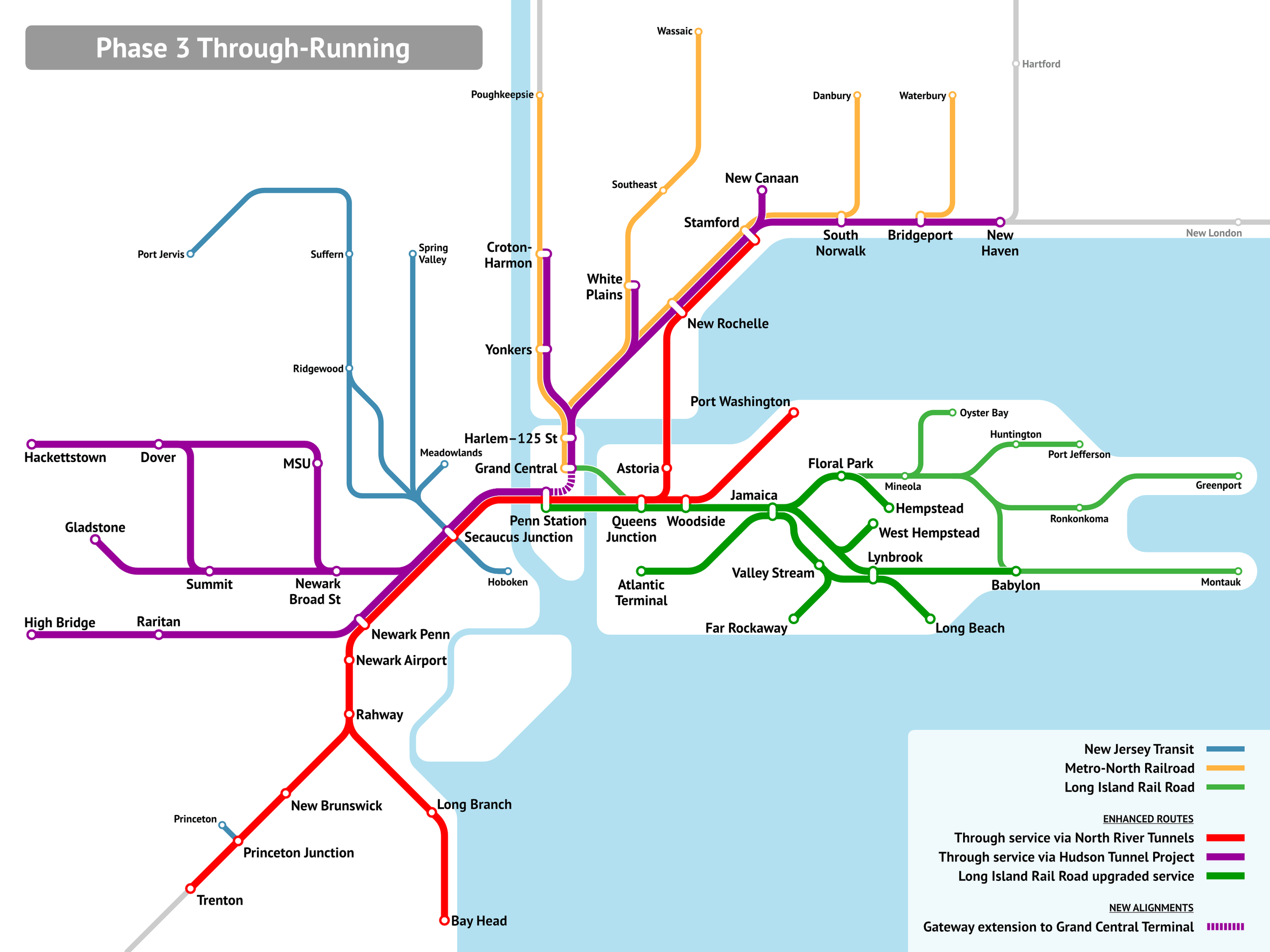
The upshot of this is that even with the dominance of Manhattan, any reasonable through-running system cobbled from existing and under construction infrastructure would unlock commutes from east of the Hudson to Downtown Newark, and from west of the Hudson to Long Island City (the station labeled Queens Junction is essentially Sunnyside Junction, walkable to a large fraction of Long Island City jobs), Flushing, and Jamaica.
It’s important context to understand why the RPA graphics denigrating through-running as limited in use don’t work:

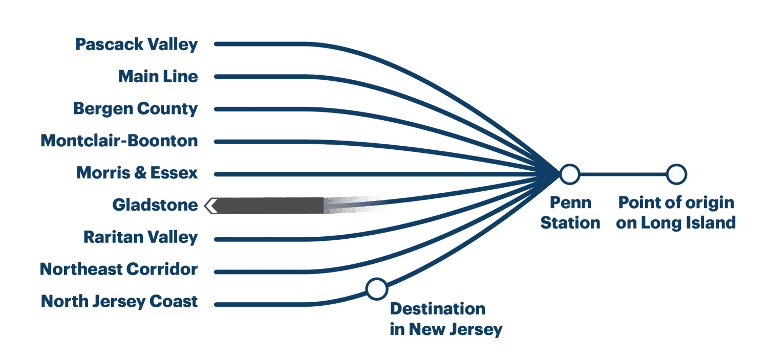
In truth, even setting aside a Penn-Grand Central tunnel (which is doable at MTA construction costs at a lower cost than Penn expansion), the destination in New Jersey is likely to be not just on the North Jersey Coast Line as depicted, but on any of the Northeast Corridor, North Jersey Coast, and Raritan Valley Lines. At present, the first two carry 14 trains per hour at the peak, and are decently likely to be one’s pair east of the Hudson. Similarly, one’s destination east of Penn Station is unlikely to be Long Island as commonly defined to exclude Brooklyn and Queens but rather to be on the trunk in Long Island City or on multiple branches within the city or perhaps on the New Haven Line.
The upshot is a hefty share of the total through-Manhattan market would in fact be served by a through-running system, usually with one-seat rides, or if not then with transfers at Sunnyside or Secaucus rather than New York. Through-running is not about those mythical trips from Oyster Bay to the Jersey Shore that Adirondacker in the comments section mocks, just as it isn’t about trips from Aulnay to IHES on the RER B or from the Marne-la-Vallée branch of the RER A to Saint-Germain-en-Laye. It’s about the overlapping near-center markets, individually small compared with commutes to the central business district and yet collectively significant.
Quick Note: Commuter Rail and Urban Bus Hubs
I’d like to introduce the concept of bus hubs with commuter rail connections, but in an urban rather than suburban context. This comes from the project we’re working on to about Queens buses on the assumption that LIRR is modernized, but it should generalize. The suburban bus context is a town center that buses converge on from many directions; the urban one is embedded in a much larger street network that must have multiple stops, and therefore the hub must be planned around both bus and rail service at once, rather than in a rail-first hierarchy.
The importance of two-way planning here is that within an urban grid, there usually aren’t obvious town centers, unless they are built. The topic of this discussion is not city center but outer areas where the commuter trains provide walk-on service, or would if they ran at modern (i.e. non-American) frequencies and charged the same fares as the buses and subway. For example, take Eastern Queens in and east of Jamaica:
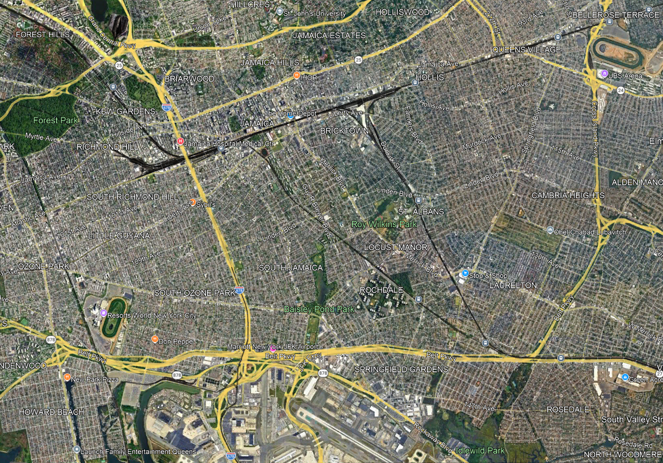
Jamaica is an obvious node, and nearly all LIRR trains already stop there and the rest should, but farther east, it’s a question of how to set up the LIRR to interact better with the city, including its buses. A lot of questions and tradeoffs have to be addressed all at once:
- Stop spacing, trading off station access time with trip times. The LIRR on the Main Line has four tracks through Floral Park so any infill station would be local-only, but that still matters for riders from points east like Floral Park and Hempstead. On the Atlantic Branch and the Montauk Line there are only two tracks, and extensive suburban ridership that would be slowed down by additional stops.
- Intersections with main arterial streets that make for natural bus connection points. The Queens Village LIRR station is at the intersection with Springfield Boulevard, but a little to its west Francis Lewis intersects the Main Line without an LIRR stop, while Hollis is not so well integrated with the street network (it’s near Farmers Boulevard, which more or less parallels the Monrauk Line). On the Montauk Line and Atlantic Branch, strong east-west bus connection points are useful; St. Albans is at the intersection with Linden, but the Atlantic Branch has no such stop at the intersection with Linden.
- Stops that permit buses to avoid congested nodes, in this case Jamaica; farther north, off-map, the same is true of Flushing. One of the goals of bus redesigns replacing traditional radial networks with grid is to get buses out of the areas where they are the slowest; this was explicit in the replacement of the radial network with the Nova Xarxa grid, increasing average speed even without any other interventions like bus lanes and stop consolidation.
- Some bus routes duplicate rail routes and could be removed or curtailed, if enough infill stops are built: for example, Merrick and Guy R. Brewer Boulevards are very closely parallel to the Montauk Line and Atlantic Branch respectively.
Without doing more detailed work yet, I suspect that the speed-access tradeoff encourages more infill stops on the Main Line and Atlantic Branches and fewer or even none on the Montauk Line, since the Atlantic Branch only continues to fairly close-in suburbs whereas Montauk carries the Babylon Branch on it, and that the buses can then be moved to a grid to connect with these stations. But the point is that this is not a decision that can be made rail-first, unlike timed connections in secondary cities and suburban town centers. The top-down hierarchy that for example Marco Chitti brings up when setting up a Takt system breaks down when one does coordinated bus-rail planning within the city.
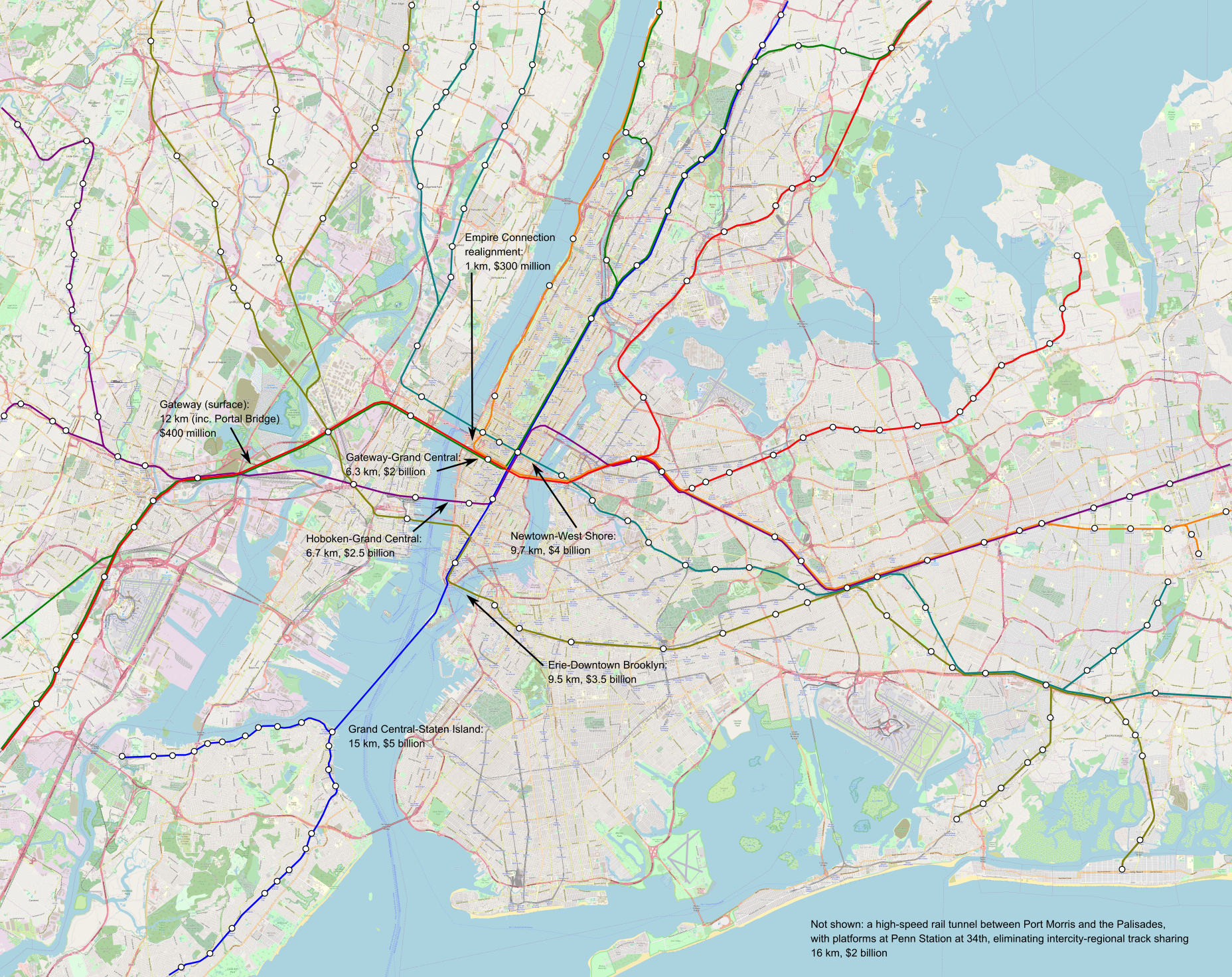
Quick Note: The Importance of Penn Station Access West to Through-Running
A video by the Joint Transit Association talks at length about through-running in New York – which lines are easier and which are harder, what some of the tradeoffs are, what sequencing works best with ongoing infrastructure plans starting with the Gateway tunnel. It’s a good video and I recommend watching – and not just because it gets a lot of its ideas from ETA reports but also because of its own analysis and own points (about, for example, Mott Haven Junction) – but it has one miss that I’d like to highlight: it neglects Penn Station Access West, the proposal to connect the Hudson Line to Penn Station via the Empire Connection.
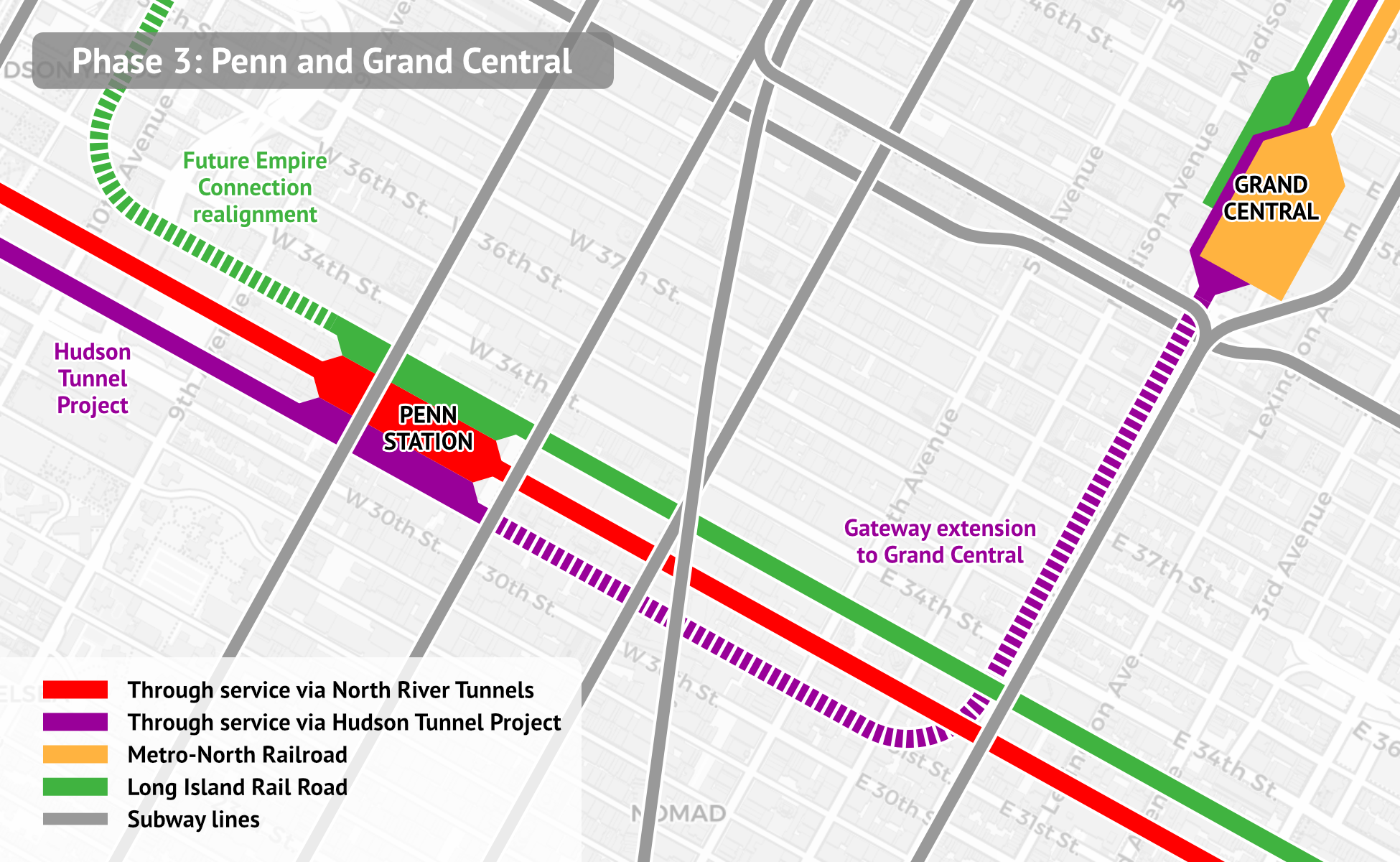
The issue is that without the realignment, too many trains would be going into Grand Central – all preexisting Metro-North service minus trains diverted to Penn Station Access. We expect all this through-running infrastructure to add to peak demand substantially. Today it fills about 50 peak trains per hour, which a four-track trunk line would struggle with (Metro-North runs trains three-and-one at the peak). Even with diversion of 6-10 trains to Penn Station Access, the extra demand would saturate the line. Penn Station Access West is important in reducing this capacity crunch.
The realignment is both important and cheap. The Empire Connection exists and the tunnel has room for two tracks; it needs a short realignment to reach the right part of Penn Station – the high-numbered northern tracks as in the image, where today there is a single-track link from the Connection proper to the low-numbered tracks – but that realignment is much cheaper than a full through-tunnel such as between Penn Station and Grand Central or the various lines to Lower Manhattan mooted for longer-term plans.
The total capacity produced should be every train that doesn’t have to go to Grand Central. It’s hard to exactly say what the split should be – there should be a minimum of a train every 10 minutes to each destination, if only to serve the inner stations that are (or would be infill) on the lower Hudson Line or the Empire Connection before the two routes meet at Spuyten Duyvil. Beyond that it’s a matter of measuring demand and seeing what the limit of timed connections are; ideally there should be 12 peak trains per hour on Penn Station Access West and only 6 on the preexisting route, up from 14 total on the Hudson Line today due to service improvements brought by through-running and related upgrades. This is necessary to create the capacity to run more service on the other lines – today the Harlem Line peaks at 16 trains per hour and the New Haven Line at 20, but these upgrades would create a lot more demand and my assumption in sketching through-running tunnels is that the Harlem Line would need 24 and the New Haven Line would need 18 to Grand Central and 6 on Penn Station Access.
Reverse-Branching on Commuter Rail
Koji asked me 3.5 days ago about why my proposal for New York commuter rail through-tunnels has so much reverse-branching. I promised I’d post in some more detail, because in truth, reverse-branching is practically inevitable on every commuter rail system with multiple trunk lines, even systems that are rather metro-like like the RER or the S-Bahns here and in Hamburg.

This doesn’t mean that reverse-branches, in this case the split from the Görlitzer Bahn trunk toward the Stadtbahn via S9 and the Ring in two different directions via S45/46/47 and S8/85, are good. It would be better if Berlin invested in turning this trunk into a single trunk into city center, provided it were ready to build a third through-city line (in fact, it is, but this project, S21, essentially twins the North-South Tunnel). However, given the infrastructure or small changes to it, the current situation is unavoidable.
Moreover, the current situation is not the end of the world. The reasons such reverse-branches are not good for the health of the system are as follows:
- They often end up creating more frequency outside city center than toward it.
- If there is too much interlining, then delays on one branch cascade to the others, making the system more fragile.
- If there is too much interlining, then it’s harder to write timetables that satisfy every constraint of a merge point, even before we take delays into account.
All of these issues are more pressing on a metro system than on a commuter rail system. The extent of branching on commuter rail is such that running each line as a separate system is unrealistic; tight timetabling is required no matter what, and in that case, the lines could reverse-branch if there’s no alternative without much loss of capacity. The S-Bahn here is notoriously unreliable, but that’s the case even without cascading delays on reverse-branches – the system just assumes more weekend shutdowns, less reliable systems (28,000 annual elevator outages compared with 1,800 on the similar-size U-Bahn), and worse maintenance practices.
So, on the one hand, the loss from reverse-branching is reduced. On the other hand, it’s harder to avoid reverse-branching on commuter rail. The reason is that, unlike a metro (including a suburban metro), the point of the system is to use old commuter lines and connect them to form a usable urban and suburban service. Because the system relies on old lines more, it’s less likely that they’re at the right places for good connections. In the case of Berlin, it’s that there’s an east-west imbalance that forces some east-center-east lines via S8, which was reinforced by the context of the Cold War and the Wall.
In the case of New York, consider this map:
The issue is that too much traffic wants to use the Northeast Corridor lines in both New Jersey and Connecticut. Therefore, it’s not possible to segregate everything, with lines using the preexisting North River Tunnels and the new Gateway tunnels having to share tracks. It’s not optimal, but it’s what’s possible.
Transit-Oriented Development and Rail Capacity
Hayden Clarkin, inspired by the ongoing YIMBYTown conference in New Haven, asks me about rail capacity on transit-oriented development, in a way that reminds me of Donald Shoup’s critique of trip generation tables from the 2000s, before he became an urbanist superstar. The prompt was,
Is it possible to measure or estimate the train capacity of a transit line? Ie: How do I find the capacity of the New Haven line based on daily train trips, etc? Trying to see how much housing can be built on existing rail lines without the need for adding more trains
To be clear, Hayden was not talking about the capacity of the line but about that of trains. So adding peak service beyond what exists and is programmed (with projects like Penn Station Access) is not part of the prompt. The answer is that,
- There isn’t really a single number (this is a trip generation question).
- Moreover, under the assumption of status quo service on commuter rail, development near stations would not be transit-oriented.
Trip generation refers to the formula connecting the expected car trips generated by new development. It, and its sibling parking generation, is used in transportation planning and zoning throughout the United States, to limit development based on what existing and planned highway capacity can carry. Shoup’s paper explains how the trip and parking generation formulas are fictional, fitting a linear curve between the size of new development and the induced number of car trips and parked cars out of extremely low correlations, sometimes with an R^2 of less than 0.1, in one case with a negative correlation between trip generation and development size.
I encourage urbanists and transportation advocates and analysts to read Shoup’s original paper. It’s this insight that led him to examine parking requirements in zoning codes more carefully, leading to his book The High Cost of Free Parking and then many years of advocacy for looser parking requirements.
I bring all of this up because Hayden is essentially asking a trip generation question but on trains, and the answer there cannot be any more definitive than for cars. It’s not really possible to control what proportion of residents of new housing in a suburb near a New York commuter rail stop will be taking the train. Under current commuter rail service, we should expect the overwhelming majority of new residents who work in Manhattan to take the train, and the overwhelming majority of new residents who work anywhere else to drive (essentially the only exception is short trips on commuter rail, for example people taking the train from suburbs past Stamford to Stamford; those are free from the point of view of train capacity). This is comparable mode choice to that in the trip and parking generation tables, driven by an assumption of no alternative to driving, which is correct in nearly all of the United States. However, figuring out the proportion of new residents who would be commuting to Manhattan and thus taking the train is a hard exercise, for all of the following reasons:
- The great majority of suburbanites do not work in the city. For example, in the Western Connecticut and Greater Bridgeport Planning Regions, more or less coterminous with Fairfield County, 59.5% of residents work within one of these two regions, and only 7.4% work in Manhattan as of 2022 (and far fewer work in the Outer Boroughs – the highest number, in Queens, is 0.7%). This means that every new housing unit in the suburbs, even if it is guaranteed the occupant works in Manhattan, generates demand for more destinations within the suburb, such as retail and schools.
- The decision of a city commuter to move to the suburbs is not driven by high city housing prices. The suburbs of New York are collectively more expensive to live in than the city, and usually the ones with good commuter rail service are more expensive than other suburbs. Rather, the decision is driven by preference for the suburbs. This means that it’s hard to control where the occupant of new suburban housing will work purely through TOD design characteristics such as proximity to the station, streets with sidewalks, or multifamily housing.
- Among public transportation users, what time of day they go to work isn’t controllable. Most likely they’d commute at rush hour, because commuter rail is marginally usable off-peak, but it’s not guaranteed, and just figuring the proportion of new users who’d be working in Manhattan at rush hour is another complication.
All of the above factors also conspire to ensure that, under the status quo commuter rail service assumption, TOD in the suburbs is impossible except perhaps ones adjacent to the city. In a suburb like Westport, everyone is rich enough to afford one car per adult, and adding more housing near the station won’t lower prices by enough to change that. The quality of service for any trip other than a rush hour trip to Manhattan ranges from low to unusable, and so the new residents would be driving everywhere except their Manhattan job, even if they got housing in a multifamily building within walking distance of the train station.
This is a frustrating answer, so perhaps it’s better to ask what could be modified to ensure that TOD in the suburbs of New York became possible. For this, I believe two changes are required:
- Improvements in commuter rail scheduling to appeal to the growing majority of off-peak commuters as well as to non-commute trips. I’ve written about this repeatedly as part of ETA but also the high-speed rail project for the Transit Costs Project.
- Town center development near the train station to colocate local service functions there, including retail, a doctor’s office and similar services, a library, and a school, with the residential TOD located behind these functions.
The point of commercial and local service TOD is to concentrate destinations near the train station. This permits trip chaining by transit, where today it is only viable by car in those suburbs. This also encourages running more connecting bus service to the train station, initially on the strength of low-income retail workers who can’t afford a car, but then as bus-rail connections improve also for bus-rail commuters. The average income of a bus rider would remain well below that of a driver, but better service with timed connections to the train would mean the ridership would comprise a broader section of the working class rather than just the poor. Similarly, people who don’t drive on ideological or personal disability grounds could live in a certain degree of comfort in the residential TOD and walk, and this would improve service quality so that others who can drive but sometimes choose not to could live a similar lifestyle.
But even in this scenario of stronger TOD, it’s not really possible to control train capacity through zoning. We should expect this scenario to lead to much higher ridership without straining capacity, since capacity is determined by the peak and the above outline leads to a community with much higher off-peak rail usage for work and non-work trips, with a much lower share of its ridership occurring at rush hour (New York commuter rail is 67-69%, the SNCF part of the RER and Transilien are about 46%, due to frequency and TOD quality). But we still have no good way of controlling the modal choice, which is driven by personal decisions depending on local conditions of the suburb, and by office growth in the city versus in the suburbs.
Timetable Padding Practices
Two weeks ago, the Wall Street Journal wrote this piece about our Northeast Corridor report. Much of it was based on a series of interviews William Boston did with me, explaining what the main needs on the corridor are. One element stands out since the MTA responded to what I was saying about schedule padding – I talk about how Amtrak and Metro-North both pad the timetables on the Northeast Corridor by about 25%, turning a technical travel time of an hour into 1:15 (best practices are 7%), and in response, the MTA said that they pad their schedules 10% and not 7%. This is an incorrect understanding of timetable padding, which speaks poorly to the competence of the schedule planners and managers at Metro-North.
The article says,
Aaron Donovan, a spokesman for the Metropolitan Transportation Authority, says the extra time built into Metro-North schedules generally averages 10%, depending on destination and length of trips, and takes into account routine track maintenance and capital work that can increase runtime. Metro-North continually reviews models, signal timing, equipment, and other elements of operation to improve travel times and reliability for customers, he says.
This is, to be clear, incorrect. Metro-North routinely recovers longer delays than 10%; delay recovery on the New Haven Line can reach well over 20 minutes out of a nominally two-hour trip, around 25% of the unpadded trip length. The reason this is incorrect isn’t that Donovan is dishonest or incompetent (he is neither of these two things), but almost certainly that the planners he spoke with genuinely believe they only pad 10%, because they, like all American railroaders, do not know how modern rail scheduling is done.
Modern rail scheduling practices in the higher-reliability parts of Europe and Japan start with the technical timetable, based on the actual speed zones and trains’ performance characteristics. This includes temporary speed restrictions. The ideal maintenance regime does not use them, instead relying on regular nighttime maintenance windows during which all tracks are out of service. However, temporary restrictions may exist if a line is taken out of service and trains are rerouted along a slower route, which is regrettably common in Germany. Modern signaling systems are capable of incorporating temporary speed restrictions – this is in fact a core requirement for American positive train control (PTC), since American maintenance practices rely on extensive temporary restrictions for work zones and one-off slowdowns. If the signal system knows the exact speed zones on each section of track, then so can the schedule planners.
The schedule contingency figure is computed relative to the best technical schedule. It is not computed relative to any assumption of additional delays due to dispatch holds or train congestion. The 7% figure used in Switzerland, Sweden, and the Netherlands takes care of the high levels of congestion on key urban segments.
The core urban networks in these countries stack favorably with Metro-North in track utilization. The Hirschengraben Tunnel in Zurich runs 18 S-Bahn trains per hour in each direction most of the day and 20 at rush hour with some extra S20 runs, and the Weinberg Tunnel runs 8 S-Bahn trains per hour and if I understand the network graphic right 7.5 additional intercities per hour. I urge people to go look at the graphic and try tracking down the lines just to see how extensively branched and reverse-branched they are; this is not a simple network, and delays would propagate. The reason the Swiss rail network is so punctual is that, unlike American rail planning, it integrates infrastructure and timetable development. This means many things, but what is relevant here is that it analyzes where delays originate and how they propagate, and focuses investments on these sections, grade-separating problematic flat junctions if possible and adding pocket tracks if not.
Were I to only take timetable padding into account relative to an already more tolerant schedule incorporating congestion and signaling limitations, I would cite much lower figures for timetable padding. Switzerland speaks of a uniform 7% pad, but in Sweden the figures include two components, a percentage (taking care of, among other things, suboptimal driver behavior) and a fixed number of minutes per 100 km, which at current intercity speeds resolve to 7% as in Switzerland. But relative to the technical trip time, the pad factors based on both observed timetable recovery and actual calculations on current speed zones are in the 20-30% range, and not 10%.
Of course, at no point do I suggest that Metro-North and Amtrak could achieve 7% right now, through just writing more aggressive timetables. To achieve Swiss, Dutch, and Swedish results, they would need Swiss, Dutch, or Swedish planning quality, which is sorely lacking at both railroads. They would need to write better timetables – not just more aggressive ones but also simpler ones: Metro-North’s 13 different stopping patterns on New Haven Line trains out of 16 main line peak trains per hour should be consolidated to 2. This is key to the plan – the only way Northern Europe makes anything work is with fairly rigid clockface timetables, so that one hour or half-hour is repeated all day, and conflicts can be localized to be at the same place every time.
Then they would need to invest based on reliability. Right now, the investment plans do not incorporate the timetable, and one generally forward-thinking planner found it odd that the NEC report included both high-level infrastructure proposals and proposed timetables to the minute. In the United States, that’s not the normal practice – high-level plans only discuss high-level issues, and scheduling is considered a low-level issue to be done only after the concrete is completed. In Northern European countries with competently-run railways and also in Germany, the integration of the timetable and infrastructure is so complete that draft network graphics indicating complete timetables of every train to the minute are included in the proposal phase, before funding is committed. In Switzerland, such a timetable is available before the associated infrastructure investments go to referendum.
Under current American planning, the priorities for Metro-North are in situ bridge replacements in Connecticut because their maintenance costs are high even by Metro-North’s already very expensive standards. But under good planning, the priority must be grade-separating Shell Interlocking (CP 216) just south of New Rochelle, currently a flat junction between trains bound for Grand Central and ones bound for Penn Station. The flat junctions to the branches in Connecticut need to be evaluated for grade-separation as well, and I believe the innermost, to the New Canaan Branch, needs to be grade-separated due to its high traffic while the ones to the two farther out branches can be kept flat.
None of this is free, but all of this is cheap by the standards of what the MTA is already spending on Penn Station Access for Metro-North. The rewards are substantial: 1:17 trip times from New Haven to Grand Central making off-peak express stops, down from 2 hours today. The big ask isn’t money – the entire point of the report is to figure out how to build high-speed rail on a tight budget. Rather, the big ask is changing the entire planning paradigm of intercity and commuter rail in the United States from reactive to proactive, from incremental to comfortable with groun-up redesigns, from stuck in the 1950s to ready for the transportation needs of the 21st century.
How One Bad Project Can Poison the Entire Mode
There are a few examples of rail projects that fail in a way that poisons the entire idea among decisionmakers. The failures can be total, to the point that the project isn’t built and nobody tries it again. Or the outcome can be a mixed blessing: an open project with some ridership, but not enough compared with the cost or hassle, with decisionmakers still choosing not to do this again. The primary cases I have in mind are Eurostar and Caltrain electrification, both mixed blessings, which poisoned international high-speed rail in Europe and rail electrification in the United States respectively. The frustrating thing about both projects is that their failures are not inherent to the mode, but rather come from bad project management and delivery, which nonetheless is taken as typical by subsequent planners, who benchmark proposals to those failed projects.
Eurostar: Flight Level Zero airline
The infrastructure built for Eurostar is not at all bad: the Channel Tunnel, and the extensions of the LGV Nord thereto and to Brussels. The UK-side high-speed line, High Speed 1, had very high construction costs (about $160 million/km in today’s prices), but it’s short enough that those costs don’t matter too much. The concept of connecting London and Paris by high-speed rail is solid, and those trains get a strong mode share, as do trains from both cities to Brussels.
Unfortunately, the operations are a mess. There’s security and border control theater, which is then used as an excuse to corral passengers into airline-style holding areas with only one or two boarding queues for a train of nearly 1,000 passengers. The extra time involved, 30 minutes at best and an hour at worst, creates a serious malus to ridership – the elasticity of ridership with respect to travel time in the literature I’ve seen ranges from -1 to -2, and at least in the studies I’ve read about local transit, time spent out of vehicle usually counts worse than time spent on a moving train (usually a factor of 2). It also holds up tracks, which is then used as an excuse not to run more service.
The excusemaking about service is then used to throttle the service offer, and raise prices. As I explain in this post, the average fare on domestic TGVs is 0.093€/passenger-km, whereas that on international TGV services (including Eurostar) is 0.17€/p-km, with the Eurostar services costing more than Lyria and TGV services into Germany. This includes both Eurostar to London and the services between Paris and Brussels, which used to be called Thalys, which have none of the security and border theater of London and yet charge very high fares, with low resulting ridership.
The origin of this is that Eurostar was conceived as a partnership between British and French elites, in management as well as the respective states. They thought of the Chunnel as a flashy project, fit for high-end service, designed for business travelers. SNCF management itself believes in airline-style services, with fares that profiteer off of riders; it can’t do it domestically due to public pressure to keep the TGV affordable to the broad public, but whenever it is freed from this pressure, it builds or recommends that others build what it thinks trains should be like, and the results are not good.
What rail advocates have learned from this saga is that cross-border rail should decenter high-speed rail. Their first association of cross-border high-speed rail is Eurostar, which is unreasonably expensive and low-ridership even without British border and security theater. Thus, the community has retreated from thinking in terms of infrastructure, and is trying to solve Eurostar’s problem (not enough service) even on lines where they need competitive trip times before anything else. Why fight for cross-border high-speed rail if the only extant examples are such underperformers?
This dovetails with the mentality that private companies do it better than the state, which is dominant at the EU level, as the eurocrats prefer not to have any visible EU state. This leads to ridiculous press releases by startups that lie to the public or to themselves that they’re about to launch new services, and consultant slop that treats rail services as if they are airlines with airline cost structures. Europe itself gave up on cross-border rail infrastructure – the EU is in panic mode on all issues, the states that would be building this infrastructure (like Belgium on Brussels-Antwerp) don’t care, and even bilateral government agreements don’t touch the issue, for example France and Germany are indifferent.
Caltrain: electrification at extreme costs
In the 2010s, Caltrain electrified its core route from San Francisco to Tamien just south of San Jose Diridon Station, a total length of 80 km, opening in 2024. This is the only significant electrification of a diesel service in the United States since Amtrak electrified the Northeast Corridor from New Haven to Boston in the late 1990s. The idea is excellent: a dense corridor like this with many stations would benefit greatly from all of the usual advantages of electrification, including less pollution, faster acceleration, and higher reliability.
Unfortunately, the costs of the project have been disproportionate to any other completed electrification program that I am aware of. The entire Caltrain Modernization Project cost $2.4 billion, comprising electrification, resignaling (cf. around $2 million/km in Denmark for ETCS Level 2), rolling stock, and some grade crossing work. Netting out the elements that are not direct electrification infrastructure, this is till well into the teens of millions per kilometer. Some British experiments have come close, but the RIA Electrification Challenge overall says that the cost on double track is in the $3.8-5.7 million/km range in today’s prices, and typical Continental European costs are somewhat lower.
The upshot is that Americans, never particularly curious about the world outside their border, have come to benchmark all electrification projects to Caltrain’s costs. Occasionally they glance at Canada, seeing Toronto’s expensive electrification project and confirming their belief that it is far too expensive. They barely look at British electrification projects, and never look at ones outside the English-speaking world. Thus, they take these costs as a given, rather than as a failure mode, due to poor design standards, poor project management, a one-off signaling system that had very high costs by American standards, and inflexible response to small changes.
And unfortunately, there was no pot of gold at the end of the Caltrain rainbow. Ridership is noticeably up since electric service opened, but is far below pre-corona levels, as the riders were largely tech workers and the tech industry went to work-from-home early and has still not quite returned to the office, especially not in the Bay Area. This one failure, partly due to unforeseen circumstances, partly due to poor management, has led to the poisoning of overhead wire electrification throughout the United States.
S-Bahn and RER Ridership is Urban
People in my comments and on social media are taking it for granted that investments into modernizing commuter rail predominantly benefit the suburbs. Against that, I’d like to point out how on the modern commuter rail systems I know best – the RER and the Berlin S-Bahn – ridership is predominantly urban. Whereas the typical American commuter rail use case is a suburban resident commuting to a central business district job at rush hour, the typical use case on the commuter trains here is an urban resident going to work or a social outing in or near city center. Suburban ridership is strong by American standards, benefiting from being able to piggyback on the high frequency and levels of physical investment produced by the urban ridership.
Here’s Berlin’s passenger traffic density on the U- and S-Bahn, as of 2016 (source, p. 6):

The busiest section of the S-Bahn is the Stadtbahn from Ostkreuz to Hauptbahnhof, with about 160,000 passengers per weekday through each interstation. The eastern sections of both the north and the south arms of the Ringbahn are close, with about 150,000 each, and the North-South Tunnel has 100,000. These traffic density levels extend into outer urban neighborhoods outside the ring – ridership on the Stadtbahn trunk remains high well into Lichtenberg – but by the time the trains cross city limits, ridership is rather low. All tails crossing city limits combined have 150,000 riders/day, so a little more than a quarter of the ridership density on the city center segments. Of those tails, the busiest, with a traffic density of 24,000/day, is to Potsdam, which is a suburb but is an independent job center rather than a pure commuter suburb like the rest of the towns in Brandenburg adjacent to Berlin.
I don’t have similar graphics for Paris, only a table of ridership on the SNCF-RER and Transilien by station and time of day and a separate table with annual ridership on the RATP-RER and Métro. But the results there are similar. Total boardings on the RATP-RER in 2019 was 399 million, of which 52 million originated in stations in the Grande Couronne, 186 million in the Petite Couronne, and 161 million in the city. If we double the Grande Couronne boardings, to account for the fact that just about all of those riders are going to the city or a Petite Couronne job center like La Défense, then we get just over a quarter of overall ridership, a similar result to the traffic density of Berlin. On the SNCF-RER, the share of the Grande Couronne is higher, around half.
The city stations include job centers and transfer points from mainline rail and the Métro – there aren’t 47 million people a year whose residential origin station is Gare du Nord – so it’s best to view the system as one used predominantly by Petite Couronne residents, with a handful using it as I did internally to the city and another handful commuting in from the Grand Couronne. This is technically suburban, but the Petite Couronne is best viewed as a ring of city neighborhoods that are not annexed to the city for sociopolitical reasons; the least dense of its three departments, Val-de-Marne, is denser than the densest German city, Munich.
The difference in this pattern with the United States is not hard to explain. Here and in Paris, commuter rail charges the same fares as the subway, runs every 5-10 minutes in urban neighborhoods (even less on the city center trunks), and makes stops at the rate of an express subway line. Of course urban residents use the trains, and we greatly outnumber suburbanites among people traveling to city center. It’s the United States that’s weird, with its suburb-only rail system stuck in the Mad Men era trying to stick with its market of Don Drapers and Pete Campbells.
Quick Note: RER and S-Bahn Line Length
An email correspondent asks me about whether cities should build subway or commuter rail lines, and Adirondacker in comments frequently compares the express lines in New York to the RER. So to showcase the difference, here are some lines with their lengths. The length is measured one-tailed, from a chosen central point.
| Line | Central point | Length (km) |
| RER A to MLV | Les Halles | 37 |
| RER A to Cergy | Les Halles | 40.5 |
| RER B to CDG | Les Halles | 31 |
| RER B to Saint-Rémy | Les Halles | 32.5 |
| RER D to Malesherbes | Les Halles | 79 |
| Crossrail to Shenfield | Farringdon | 34 |
| Crossrail to Reading | Farringdon | 62.5 |
| Thameslink to Brighton | Farringdon | 81 |
| Thameslink to Bedford | Farringdon | 82 |
Express subway lines in New York never go that far; the A train, the longest in the system, is 50 km two-tailed, and not much more than 30 km one-tailed to Far Rockaway. The Berlin S-Bahn is about comparable, in a metro area one quarter the size.
