West Station is an Overbuilt Mess
Boston has been on a commuter rail infill binge lately; it has opened four stations on the Fairmount Line this decade, with general success, and is now eying the Worcester Line, where the MBTA has already opened a single in-city station called Boston Landing. The next station to be opened is called West Station, serving Allston, a middle-class urban neighborhood home to Boston University. Unfortunately, the West Station project has suffered from budget and schedule overruns: the current projection is $90 million, where past stations in the area have opened for about $15-25 million each, and construction will start next decade and only wrap up by 2040.
The cause of the extreme cost is poor design. The station as currently proposed is an overbuilt mess. It is development-oriented transit, sited next to an area that Harvard wishes to redevelop as a new campus, and the compromises made between good rail service, intermodal bus-rail connections, and encouraging development make the project fail at all of its objectives. The idea of an infill station in Allston is solid and the MBTA should keep working on the project, but it should do it right – that is, maximize passenger utility while also slashing the budget by a factor of about 4.
I encourage readers to look at a presentation about the status of the project from May, and at another presentation from June, which was sent to members of the media and neighborhood.
Intermodal integration done wrong
The West Station site is roughly in the center of the new development. Unfortunately, it is poorly-located relative to the street network. With its hierarchy of major and minor streets, Boston is not forgiving to wrong station siting: buses would have to meander to reach the site.
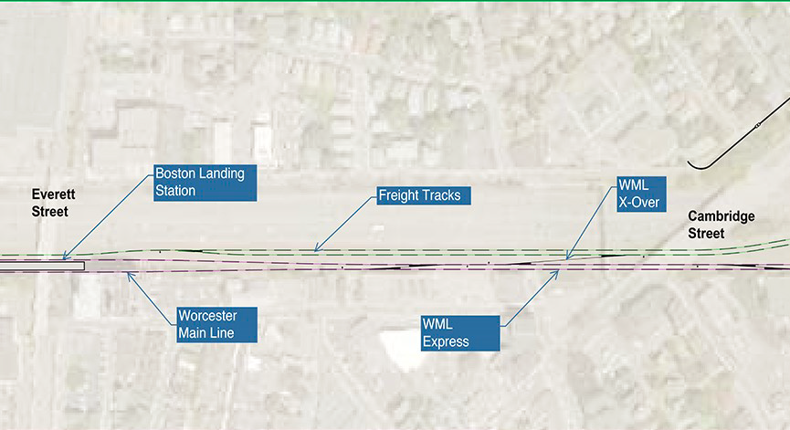
The busiest bus in the area, and among the busiest in the region, is the 66. See image below:

The Red and Green Lines of the subway are in their respective colors (and the Green Line’s branches are surface light rail), the Worcester Line is in purple with its existing stations marked alongside the proposed West Station site, and the 66 bus is in black. The dashed purple line is the disused Grand Junction Railroad – see below for more explanation.
North of the West Station site, the bus could still reach the platforms relatively easily, as the plan includes mapping new streets over the entire site. But to the south, the streets are narrow and practically unusable. All north-south through-traffic is funneled through Harvard Avenue – anything else would meander at speeds not much higher than that of walking.
What’s more, the zigzag in the image above comes from a detour to the center of Allston, called Union Square. The West Station site would move service farther away from Union Square, forcing it to either abandon its single busiest stop or have a more circuitous route. Serving both West Station and Union Square requires running two separate north-south bus routes sharing much of their southern legs, which is bad for frequency. Already the 66 runs every 10 minutes off-peak in one direction and every 14 in the other; this is worse than the minimum acceptable on such a key route, and any further reduction in frequency through route splitting is unacceptable.
Finally, the station design as shown in the presentations includes ample room for bus bays, so that buses can terminate at the station. Such a layout may be appropriate at the center of a small town with timed bus-rail transfers; in the middle of the city, it is pointless. The 66 crosses the rail tracks and has no use for terminal berths. Nor is there any need for terminating buses running parallel to the tracks – passengers could walk to another train station on the Worcester Line or on the Green Line.
The MBTA has never released any public plan for a bus redesign around West Station. It talks about intermodal transfers but refuses to give any details, and it’s likely these details don’t even exist yet. There are occasional excuses, such as intercity buses (why would they terminate there instead of continuing to South Station?), buses to Kendall Square (they don’t need bus bays either), and buses to Longwood (Longwood is south of the Worcester Line and would be better-served by a commuter rail-to-Green Line transfer near Fenway Park).
Track design for maximum conflict
The latest option for West Station is called the flip option. The diagrams below are from the June presentation, pp. 8-10, going west to east:
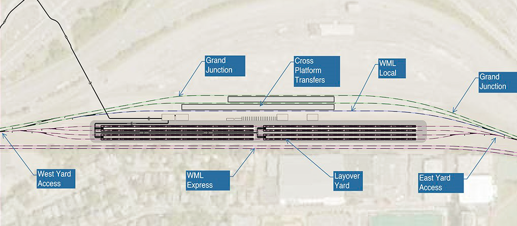
There are to be two bypass tracks (“WML Express”), located where the current mainline is. There are also to be three tracks with station access, both on the other side of the railyard. The tracks serving the platforms cross the bypass tracks in a flat junction, forcing dependency between the inbound and outbound schedule. The flat junction is not especially quick, either – it is a long ladder track, requiring inbound local trains to South Station to make two slow diverging moves in succession.
The MBTA is planning to spend tens of millions of dollars on station platforms in Newton turning the line into full double-track all the way from Boston to Worcester, freeing the schedule from such dependency, but at the same time it’s planning to add new conflicts.
While the diagrams label two tracks as freight tracks, there is little to no freight on that portion of the line. A freight rail spur in the area, serving Houghton Chemical, was just removed in preparation for the project. The line can and should be designed exclusively around the needs of regional passenger trains, for which the most important thing is continuous operation of double track, preferably with no flat junctions with oncoming traffic, and not any ancillary frills.
The Grand Junction tangential
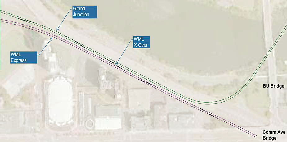
The MBTA has grandiose plans to use the Grand Junction Railroad to allow trains from Allston and points west to avoid South Station entirely. The Grand Junction provides a bypass to the west of Downtown Boston, which currently sees no passenger service but is used for non-revenue moves between the South Station and North Station networks. There are periodic plans to reactive service so as to enable trains from the west to serve Cambridge and North Station instead. In the flip option, all local trains are required to go to the Grand Junction or switch back to the mainline using the ladder track.
Consult the following table, sourced to OnTheMap, for the number of jobs accessible within walking distance of the various station sites:
| Station | Walkshed boundaries | Jobs |
| South Station | Essex, Tremont, State, the harbor | 119,191 |
| Back Bay | Hereford, Belvidere, Columbus, Arlington, Storrow | 62,513 |
| Kendall | Binney, Third, Wadsworth, Memorial, Mass Ave, Windsor, Bristol | 29,248 |
| North Station | Blossom, Cambridge, State, Prince, the river | 33,232 |
Jobs accessible on the existing mainline outnumber ones accessible via the Grand Junction by a factor of about three. It is not technically sound to avoid city center on an urban rail line, much less a suburban one. Only if the line is a consistent circumferential line is there a good reason to go around the center.
A far-future subway duplicating the 66 route may succeed. The same may be true of a shuttle using the Grand Junction, but such shuttle may well need extensive new track – West Station is not necessarily the best south-of-Charles footprint (turning east toward BU to form a loop with a future North-South Rail Link is better). In contrast, the current plan for diversion of Newton trains toward a secondary job center and away from Downtown Boston has no chance of getting substantial ridership.
The railyard as an obstacle
For a project so focused on redevelopment, West Station does not do a good job encouraging construction in the area. It plans to keep the railyard in the middle, and even forces local and express trains to go on opposite sides of it. But the railyard is an obstacle not only to sound railway operations but also to redevelopment.
Building anything over rail tracks is complicated. New York supplies a few such examples: the link mentions the difficulties of Atlantic Yards, and to that I will add that the construction of the Hudson Yards towers cost around $12,000/m^2, compared with $3,000-6,000 for Manhattan supertall office towers on firma. Hudson Yards has managed to be financially successful, albeit with tax breaks, but it’s located right outside Midtown Manhattan. Allston’s location is not so favored. The cost penalty of building over railyards is likely to make air rights unviable.
There is still an extensive portion of the site that’s on firma. However, if the point is to maximize redevelopment potential, the city and the state must discard any plans for air rights. The railyard should go in order to increase the buildable area.
In lieu of parking at a railyard in a desirable near-center location, trains should circulate back and forth between Boston and Worcester. The MBTA keeps saddling itself with capital costs because it likes running trains one-way to Downtown Boston in the morning and then back to the suburbs in the afternoon, parking them near South Station midday. This is bad practice – trains are not just for suburban salarymen’s commutes. Urban infill stations in particular benefit from high all-day frequency and symmetric service. If the MBTA needs space for train parking, it should sell the railyard in Allston and charge Allston land prices, and instead buy space in Framingham and Worcester for Framingham and Worcester land prices.
West Station, done right
Thanks to delays and cost overruns, West Station is still in preliminary design. There is plenty of time to discard the flip option as well as the original plan in favor of a route that maximizes intermodal connections at minimum cost. A better West Station should have all of the following features:
- A simple four-track design, either with two stopping tracks and two bypass tracks or four stopping tracks and two island platforms, depending on long-term plans for train timetables
- High design speed, as high as the rest of the line for nonstop trains, as the tracks are straight and do not require any speed restriction
- Retention of double-track rail service throughout construction, even at the cost of more disruption to the Massachusetts Turnpike
- No at-grade conflicts in opposing directions: tracks should go slow-fast-fast-slow or fast-slow-slow-fast rather than slow-slow-fast-fast
- No bus bays: crosstown buses (that is, the 66) should stop on the street crossing the station right above the tracks, with vertical circulation directly from the bus stop to the platform in order to minimize transferring time
- Subject to site availability, platforms reaching Cambridge Street for a connection to the present-day 66 and a shorter walk to Union Square
- Elimination of the railyard to make more room for development, and if the line needs more yard space, then the state should find cheaper land for it in Framingham and Worcester
There is no reason for such a project to cost more than past infill stations built in Boston, which have cost around $15-25 million, about the same range as Berlin. By removing unnecessary scope, the MBTA can make West Station not only cheaper and easier to build but also more useful for passengers. The idea of an infill commuter rail station in Allston is good and I commend the MBTA for it, but the current plan is overbuilt and interferes with good rail and bus operations and needs to be changed immediately, in advance of engineering and construction.

Concur that the “flip” track schematic (and single-track construction phasing) is a mess. As regards Union Square, the current Boston Landing station is closer than West Station could be, even if the west end of the platforms were shifted to butt up against the Cambridge Street overpass. And the high ridership at that stop is likely driven by transfers to other routes. If Harvard succeeds in redeveloping the railyard/interchange site at a sufficiently high density, it’s easy to see the #66 picking up ridership by using Malvern Street and the “transitway” to serve the new development, with the current Union Square transfers taking place at other intersections.
Really, the DEIR design was just about perfect. It needed two island platforms instead of the side-island-side, and the bus concourse could’ve been shrunk since it’s likely geared towards peak hour shuttle routes and campus-operated champion vans.
The cost is $90 million, so no, it’s not perfect, except for the rent-seeking consultants. Malvern Street is too narrow and forces buses to detour east-west to get back to Harvard Street going south, Boston has too low a volume of bus-bus transfers (IIRC <10%) for Union Square's high traffic to come from transfers, air rights are not redevelopable unless you're walking distance to Midtown Manhattan and such, and the correct amount of infrastructure for peak-only shuttle buses is zero.
I actually kinda like the placement of West Station. While it’s not close to the 66, the current proposed West Station placement can provide for nearly a cross-platform transfer of the B Branch and 57 bus (also on Comm. Ave.) to regional rail for an express ride to Back Bay, South Station, Aquarium, and North Station — relieving both the B and the 57 bus, which are both overcapacity.
I get the connection priorities are usually the perpendicular routes, though, and not the ones going the same direction.
Wait, how is this a cross-platform transfer to the Green Line? The current Worcester Line is 300 meters north of Comm Ave, and the planned site for West Station is on the wrong side of the railyard, so around 400 meters from Comm Ave.
You’re right that West Station can relieve the Green Line for O&D passengers, but it could provide the same functionality at Cambridge Street, and it could provide better functionality if the trains could run frequently without any flat junctions messing up the takt.
“With its hierarchy of major and minor streets, Boston is not forgiving to wrong station siting: buses would have to meander to reach the site.” This is true of virtually all cities I am familiar with, and I would expect that any planner (or non planner) should not screw up decisions like this. It’s so obvious that I feel like planners should cite their reasons and have very good ones when placing stations in the way of Egaleo station in Athens (misses 703 circumferential) or Tamien in San Jose (misses 25 crosstown) or the B line branch to the airport in Paris.. In a city like Tokyo this kind of thing is super common but since the lines are private I guess there is less impetus to blame the planners. How do you mess this up when you have total agency?!
In totally unrelated news what is your opinion of the northern crenshaw extension? By my reading the only logical choice out of the considered options is the La Brea option. But there is a significant force pushing for a much wider deviation to the west (more people within walking distance of a station but when you actually look at the estimates the ridership is virtually same and operating/capital costs on La Brea are a ridiculous amount lower.) And lastly to say one of your fantasy LA maps had the extension on Western.
I don’t think platforms reaching Cambridge St. is a good idea. That’s only 550-700m from Boston Landing, depending on the length of platforms there. On 700m, a FLIRT can make 65mph before it starts decelerating for the next stop, but the MTBA isn’t running FLIRTs in the near future.
If the station is moved 600m east, there’s a relatively straight line of Soldiers Field Road-station-Harry Aganis Way. Right now, Aganis Way isn’t a busway under the turnpike and rail lines, but it could be. The big question is that there seem to be no roads between Harvard Ave and Mountfort St. for a bus route continuing south. Is there one I’m missing?
That’s not really a good route… it’s a highway hellscape too close to the river for good station radii, and it intersects the line at a constrained location with no good reason to build a station, and then Pleasant Street is too narrow and is forced to feed Harvard Avenue south of Beacon Street anyway.
I don’t know that bus connections are important in this instance. The 66 ridership coming from the north is not looking to transfer to the train (even if you’re going from Harvard to points west on the Worcester Line it might still be faster to take the red line to South Station). Nor does it make sense to take the 66 from the south to the commuter line to the CBD: that would be really circuitous. The use cases I see for this station are (1) to give students / Allston residents a quicker ride to South Station, and (2) to allow faculty living in Newton and maybe service workers living in Framingham to get to the new Harvard campus. And (2) is probably not a big population. Meanwhile (1) would be compromised by siting the station too close to Boston Landing. On the whole I am not persuaded that West Station is needed…
Don’t shoot, I’m just the messenger – the MBTA is justifying the project on intermodality grounds, and people have defended higher-than-Fairmount’s-$16-million-infill costs on intermodality grounds.
(That said, local transit-regional rail connections are underrated and it’s useful to put in stations where people can transfer easily.)
Why can’t the 66 be rerouted via Everett St to connect with Boston Landing instead? It would actually be slightly shorter than the current routing, and could be implemented immediately (Boston Landing already has an exit to Everett St). This would eliminate the need to compromise West Station’s service to BU destinations (and overlap Boston Landing’s walkshed) by dragging it further west to Cambridge St.
Good idea. Everett is already more commercial development (i.e. development potential) than North Harvard.
They aren’t construction of the Hudson Yards towers cost around $12,000/m^2, compared with $3,000-6,000 for Manhattan supertall office towers on firma
Who is proposing to put the tallest building in New England out there? A ten or twelve story mixed use building is lot cheaper to construct than a really tall skyscraper.
The table can be sorted by year of construction
https://en.wikipedia.org/wiki/List_of_tallest_buildings_in_New_York_City
They aren’t $3,000 a square meter.
https://en.wikipedia.org/wiki/425_Park_Avenue
A billion divided by 62,000 is 16,129.03. Makes Hudson Yards look like a bargain.
https://en.wikipedia.org/wiki/111_Murray_Street
445 million construction loan, which doesn’t include whatever equity they already had, divided by 34,560 is 12,876.15
https://en.wikipedia.org/wiki/50_West_Street
600 million divided by 53,883 is 11,135.24
https://en.wikipedia.org/wiki/3_Manhattan_West
791 million divided by 70,297 is 11,252.25
I stopped looking
Bank of America Tower was around $6,000, and other New York commercial supertalls from 10-15 years ago were $3,000-5,000, except specifically the WTC buildings.
They aren’t building 15 year old buildings today. Because if you start construction in 2016 they won’t be 15 years old when they open in 2020
https://en.wikipedia.org/wiki/One_Vanderbilt
Over 20,000 per square meter. Makes Hudson Yards look cheap.
Decking over a rail yard would seem to be a rather significant capital expense just to start off or am I missing Alon’s point?
You would think it would but Hudson Yards which has complicated ventilation for all the trains that will be under it and parks on top of the trains with sophisticated drainage systems is costing about the same as other tall buildings in Manhattan. And less than some.
The Beacon Park rail yard lingers like a zombie in these renders because the T can’t (yet???) get a hold of its preferred storage site at Widett Circle: https://cdn.mbta.com/uploadedfiles/About_the_T/Board_Meetings/SouthStationExpansion.pdf#page=19. All of the Widett parcels–the Food Market in the middle of the ‘bowl’, the cold storage warehouse, and now also the City of Boston car tow lot–are up for sale, with MassDOT having intense interest. 30 trainsets of storage (>30 and/or other support facilities if the tow lot is also a buy) and air rights provisioning/underwriting to bait real estate interests. Plus, should a North-South Rail Link build significantly slash back the number of trains that have to be stored downtown, the transit storage under the air rights provision can easily be reapportioned to buses instead for consolidating 3 adjacent garages on re-developable parcels. But the sales are moving glacially because of the political pig-pile, and isn’t a certain thing for MassDOT because the wholly theoretical real estate development land interests (leftover from when this site was somebody’s acid-dream 2024 Olympic Stadium site) are mucking it all up.
Beacon Park has now been downsized to 8 trainsets of storage…less than the more generous capacity shown on p.17 of the linked PDF above. That’s not enough to offer more than maybe 3-5 actual trains’ worth of midday expansion, because the T already has to park its largest >6-car rush-hour consists at Amtrak Southampton Yard due to their own layup tracks not being long enough to hold max-size crowd swallowers. Amtrak has long been feuding with the T to get out of its yard and find their own space elsewhere, with the coming fleet renewal for the Acela and Northeast Regional trainsets being the ticking clock eventually forcing an eviction so Amtrak can have more space.
The Beacon Park easement, being the only sure thing other than inconveniently-placed Readville that they have in hand, thus isn’t any sort of proactive “expansion” piece but rather a wholly reactive lifeboat for what they can’t milk any longer at Southampton. The Providence Line is the #1 user of >6-car sets, so there will be a lot of shuffling through Back Bay of trains that won’t be doing anything at all for Worcester Line capacity except chewing it up with excessive deadheading. Worcester is the second-biggest user of monster sets, but most of those are on existing rush slots so the yard will be reserved for existing peak shift changes and not much in the way of new expansion.
If MassDOT got any of the 3 for-sale pieces at Widett Circle, the Beacon Park yard easement could be wholly deleted…tomorrow…with the stroke of a pen. The station can be compacted to sanity, and Harvard can buy another strip of land to push development up to the foot of the station. Not only is it that easy, but they dearly want to be at Widett instead of here. They just can’t today, or at least as long as the sale of the Widett parcels continues to be gridlocked by interference. Beacon Park is the land they possess today that gets them out of their Southampton storage pickle, so they have to advance design in lockstep with the whole Mass Pike/West Station project. If that yard interface design looks like a godawful mess and increasing afterthought, it’s because it literally is an afterthought in their eyes. Let’s just hope the real estate transactions break their way so it can go way entirely and spur a mass cleanup of the mess at West.
Good post.
West Station had an overbuilt design 5 years ago and it’s sad that little has changed. The idea of proposing an ‘air-rights bus terminal / layover’ was insane.
I’ve always suspected that the decision to locate Boston Landing station halfway between the historic locations of stations was going to cause perpetual trouble.
If you look at the classic Allston station location it’s at Cambridge Street. That’s the best spot for bus connections and serving the business district. The depot building remains but it’s a pizzeria now, hence Boston Landing and West Station being shunted aside from their natural locations. Although I’m not sure if you could have a four track station at the original location anymore, since the Pike was built.