High-Speed Rail and the Pacific Northwest
The Pacific Northwest seems like the perfect region for high-speed rail: its cities form a neat line from Vancouver to Portland and points south, grow at high rates with transit-oriented development, and have sizable employment cores around the train station. And yet, when I generated my high-speed rail maps, I could only include it as a marginal case, and even that inclusion was charitable:
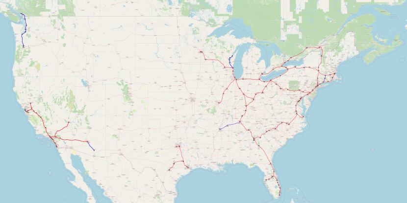
Red means lines that should definitely get high-speed rail, blue means marginal cases, some with strong medium-speed tie-ins.
(Full-size image is available here.)
There’s been a lot of criticism over why I’m including Atlanta-Jacksonville but not Vancouver-Seattle-Portland, and I’d like to explain why the model says this.
Density
The population density in the Western United States is very low. What this means in practice is that cities are far apart – the best example is Denver, a large metropolitan area that is 537 km from the nearest million-plus metro area (Albuquerque). A high-speed line can connect two cities, maybe three, but will not form the multi-city trunk that one sees in Germany or Italy, or even Spain or France. Lines can still make sense if they serve enormous cities like Los Angeles, but otherwise there just isn’t much.
This relates to Metcalfe’s law of network effects. In a dense region, the 500-800 km radius around a city will have so many other cities that network effects are obtained as the system grows. Even Florida, which isn’t dense by European standards, has cities placed closely enough that a medium-size system can connect Miami, Orlando, Tampa, and Jacksonville, and then with a 500 km extension reach Atlanta. The I-85 corridor can likewise accrete cities along the way between Washington and Atlanta and get decent ridership.
In the Pacific Northwest, any intercity infrastructure has to live off Vancouver, Seattle, and Portland – that’s it. Spokane is small, orthogonal to the main line, and separated by mountains; Salem and Eugene are small and Salem is technically in the Portland combined statistical area; California’s cities are very far away and separated by mountains that would take a base tunnel to cross at speed. And Seattle is just not that big – the CSA has 5 million people, about the same as Berlin, which has within 530 km every German metropolitan area.
The model
The model thinks that with Vancouver (2.6)-Seattle (5) at 220 km and Seattle-Portland (3.2) at 280, ridership is as follows, in millions of passengers per year in both directions combined:
| City S\City N | Vancouver | Seattle |
| Seattle | 2.33 | — |
| Portland | 1.63 | 2.76 |
In operating profits in millions of dollars per year, this is,
| City S\City N | Vancouver | Seattle |
| Seattle | 33.32 | — |
| Portland | 52.98 | 50.23 |
This is $135 million a year. It’s actually more optimistic than the official WSDOT study, which thinks the line can’t make an operating profit at all, due to an error in converting between miles and kilometers. The WSDOT study also thinks the cost of the system is $24-42 billion, which is very high. Nonetheless, a normal cost for Vancouver-Portland HSR is on the order of $15 billion, a bit higher than the norm because of the need for some tunnels and some constrained urban construction through I-5 in Seattle.
It isn’t even close. The financial ROI is 0.9%, which is below the rate of return for government debt in the very long run. Even with social benefits included, the rate is very low, maybe 2.5% – and once social benefits come into play, the value of capital rises because competing government investment priorities have social benefits too so it’s best to use the private-sector cost of capital, which is 4-5%.
This exercise showcases the value of density to intercity rail networks. You don’t need Dutch density, but Western US density is too low – the network effects are too weak except in and around California. It would be mad to build Atlanta-Jacksonville as a high-speed rail segment on its own, but once the Florida network and the I-85 network preexist, justified by their internal ridership and by the Piedmont’s connections to the Northeast, connecting Atlanta and Jacksonville becomes valuable.
Growth
The one saving grace of the Pacific Northwest is growth. That’s why it’s even included on the map. Lines in the 1.5-1.8% ROI region are not depicted at all, namely Houston-New Orleans and Dallas-Oklahoma City-Kansas City-St. Louis, both discounted because none of the cities connected has local public transportation or a strong city center. The Pacific Northwest is not discounted, and also benefits from strong growth at all ends.
The gravity model says that ridership is proportional to the 0.8th power of the population of each city connected. To get from 0.9% to 2% requires a factor of 2.2 growth, which requires each city to grow by a factor of 2.2^0.625 = 1.65.
Is such growth plausible? Yes, in the long run. In 2006-16, Metro Vancouver grew 16%; in 2010-9, the core three-county Seattle metro area (not CSA) grew 16% as well, and the core Portland metro area (again, not CSA) grew 12%. At 16% growth per decade, the populations will rise by the required factor in 34 years, so building for the 20-year horizon and then relying on ridership growth in the 2050s and 60s isn’t bad. But then that has a lot of risk embedded in it – the growth of Seattle is focused on two companies in a similar industry, and that of Vancouver is to a large extent the same industry too.
Moreover, the region’s relative YIMBYism can turn into NIMBYism fast. Metro Vancouver’s housing growth is healthy, but the region is fast running out of developable non-residential areas closer in than Surrey, which means it will need to replace single-family housing on the West Side with apartment buildings, which it hasn’t done so far. Growing construction costs are also threatening the ability of both Vancouver and Seattle to feed commuters into their central business districts by rail – Seattle may have built U-Link for costs that exist in Germany, but the Ballard/West Seattle line is $650 million/km and mostly above-ground, and the Broadway subway in Vancouver, while only C$500 million/km, is still on the expensive side by non-Anglo standards. It’s useful to plan around future growth and safeguard the line, but not to build it just on the promise of future growth, not at this stage.

I’m a reader from Canada, and I have a question: do you have an idea on how crossing a hard border affects ridership estimates? I’ve been playing with your model for both domestic Canadian routes and cross-border routes, and have modified your formula by introducing a border crossing coefficient. It still makes Toronto/Chicago/NYC, and Montreal/NYC/Boston viable, but I think Vancouver/Seattle would be completely unviable.
Seconding this question. It also raises the general point of how useful fitted values are when extrapolating from foreign context. Probably the answer is this is the best we can do. Would be good to see to what extent car trips between Van/Seattle under/over performs a north american gravity model. There are reasons to think that the tech clusters in both cities would increase linkages. But that border is a pain. If the HSR link can deal with border crossing in a really efficient way that could be pretty attractive.
Couldn’t you just put the border crossing at stations in Canada similar to EuroStar at London?
If you must. Ideally there should be someone who can successfully pull off the bed to moving train in under 5 minutes. Security theater just pushes people to drive where they don’t need to deal with security and have the advantage of their own personal car when they get there.
Ideally customs happens on the train, when you have nothing else to do, and customs hires enough people to check the entire train in the time between border stations (give them half an hour). If trains can do this they have a big advantage over cars where you need to wait in line at the border. Where this isn’t done this is a political problem, an all to real problem, and one that probably isn’t solvable if you want to have trains.
I’m inclined to suggest if you can’t do customs on train you should have two separate lines that both terminate on their side of the border. It is a cross platform transfer to the other train, but customs sits in the middle. These stations can be put in some tiny border village which then gets rail service that it otherwise wouldn’t deserve. This way lines in customs are not a problem for train schedules, just keep running trains and letting people off at the border and letting on whoever makes it through.
> Security theater just pushes people to drive where they don’t need to deal with security and have the advantage of their own personal car when they get there.
This isn’t really true of international land borders. And land crossing between the US and Canada can be awfully long.
In the same vein, there are border checks at the Eurotunnel Shuttle as well.
“Ideally customs happens on the train, when you have nothing else to do, and customs hires enough people to check the entire train in the time between border stations (give them half an hour). If trains can do this they have a big advantage over cars where you need to wait in line at the border. ”
Exactly. This makes a lot of sense, and would dramatically improve travel between those two cities. Without it, the train has to be extremely fast to compensate. With it, and the train only has to be a bit faster to gets lots of people out of their cars (or out of the airport). They should do what you propose, along with relatively cheap improvements (https://www.aawa.us/site/assets/files/7322/2006_washington_state_long-range_plan_for_amtrak_cascades.pdf).
You can almost spit across the river from Niagara Falls New York to Niagara Falls Ontario. There are roughly the same amount of people in the blotch of suburbs and cities on the western end of Lake Ontario as there are in all of Washington and Oregon. Closer together. With lots of places more interesting to go than Eugene. It would be okay if the trains from those interesting places didn’t stop every10 miles/15km in greater greater Toronto and the western end of the lake had trains that did.
Detroit and Windsor have the same problem.
There can be even cleverer things like sealing the train through Ontario saving 100miles/160km on the trip between Chicago and Detroit to Niagara Falls and beyond. Any of it will give the people who get the heebie-jeebies at the thought of furrinners frothing at the mouth. They are the ones who also think traveling is faintly immoral and cities are cesspits of sin and immorality and don’t quite understand why someone would want to leave the splendor of exurban Detroit to go to Boston or New York. Or Chicago or Toronto. Or Montreal where they speak French!!! !!!
That’s exactly what they’re doing for the Cascades. Vancouver is going to get a Customs pre-clearance facility. There are no intermediate stops within Canada, so it’ll be self-contained at the terminal and the train simply runs ‘sealed’ across the border. Sane thing will happen at Montreal for the Adirondack to do away with the Rouses Point border check, although they will have to give up the Rouses Point intermediate stop to run sealed there.
Typo…give up “St. Lambert” intermediate stop on the Adirondack to run sealed for Customs @ MTL.
If it gets the same kind of ridership as Rouse’s Point it’s no great loss. Or even Plattsburgh.
Click to access NEWYORK19.pdf
I believe that there is (since 2019) an agreement in place between US and Canada to allow for a border pre-clearance facility for US-bound trains at Montreal’s Gare Centrale. Don’t know if anything has progressed since then, though.
Says the laws were passed but building the facility and actual agreements on operating the thing did not: https://vtdigger.org/2019/08/15/preclearance-issues-extend-wait-for-rail-service-to-montreal/
2.5 questions, first, I assume that just looking at the Seattle-Vancouver pair doesn’t do the model any favors? I know that’s what’s being explored by the state right now. 1.5th, if a Seattle-Vancouver only line was feasible would a station in the U district be an option? It would be fairly easily built directly over I-5, close to the light rail line and the closest thing the city has to a second core.
Second, I’m not sure if you’ve written about Ballard/W Seattle link elsewhere, but do the two rather large bridges necessary justify the cost at all?
Thanks
U District is not really a great place to have connections to high speed rail, because there are no fast, orthogonal routes to other parts of the region at UW. (Link would run parallel, the bus to Ballard is extremely slow, and the 520 restructure never quite lived up to the promise.)
WSDOT considered the Seattle-area viable locations for stops to be Tukwila (though I’d prefer it directly at Seatac Airport), Downtown Seattle, and Bellevue. Unfortunately you can’t really serve both Downtown Seattle and Bellevue on a north-south HSR route.
If you wanted to split the difference between Seattle and Everett the most likely location would be Lynwood City Center or West Alderwood, which are more or less halfway between and also are linked via I-5 and I-405.
Unfortunately there aren’t really any orthogonal connections anywhere in Seattle, unless we’re pushing the station all the way down to Tukwila or up to Mountlake Terrace – and I’d really prefer a city center station. At UW you’d have easy access to the link to downtown and ergo to Bellevue, and it seems like by the time something like this actually gets built a UW-Ballard light rail line would be in the works. Big questions to me are, would a UW station be any cheaper to build than a Convention Center-ish station, and would it make the route thru downtown in a future Portland expansion any easier (no crisscrossing tunnels or anything of that sort).
@Dalton: I don’t think the University (or rather N 45th St) would be a good location for HSR to stop. But as I think that you can get better value for HSR by tacking it onto a Quadruple-tracking of “The Spine” to enable better Regional Rail service. Said Regional Rail service should stop at N 45th St. There’s plenty of RoW along I-5, as the corridor was built with reversible express lanes that were intended to be converted to Rapid Transit at some point, and were considered for use by Link at one point. So, constructing both stations would require major disruption to the operation o I-5, their station boxes could be contained within almost entirely within it’s envelope.
I fear that with Link going all the way up to Everett and Down to Tacoma the dream of quality regional rail in Seattle is dead for the foreseeable future. If they ever did build it honestly I think another I5 alignment might be a bit redundant with both the freeway and the Link there already. An alignment up 99/the old interurban trolley ROW could be interesting but honestly I have no idea how you get it into the city past where the old ROW terminates at 105th. Back to the topic of HSR, I wonder if you could just put the station across the street from Union/ID Link station? Avoids issues with crisscrossing tunnels going north, and allows HSR to parallel the Link tunnel south for half a mile before Link goes to the surface and HSR jogs over to the main rail line.
@Dalton: Actually I see the opposite: There’s a fundamental pressure that’s been building between those who want more closely spaced stations, and those who want get to the major destinantions quickly. Quad-tracking the spine allows for this damocles knot to be sliced in two. Link isn’t going to be any faster than Sounder, or any buses that it supposed to replace. It’s not as if this idea of express service on Light Rail is unheard of, just look at LA for instance. And it’s precisely because that the Freeway RoW is there that I think could be done without breaking an arm an a leg.
The Interurban RoW is along I-5 in Snohomish County, where Link will be running. The segmenht in Seattle should just get a Rapid Transit line of it’s own, on Hwy 99 (Elevated/Underground), though dogleging west in Fremont to hit Upper/Lower Queen Anne and Belltown.
I think the “New Mainline” should stay on I-5 through, and South of Downtown, through at least Georgetown. The issue here is elevation, as a line would need to climb over 40m while winding through a fully developed environment. And it wouldn’t save you from winding around Link. More importantly, the existing coastal route north is completely untenable as the main way for trains going north, as it’s sits at the bottom of a series of bluffs that have landslides nearly every winter, and is seriously limited by the freight traffic on the corridor.
The Northgate to downtown tunnel is already built. What’s the difference between “quadruple tracking” the spine and just building an entirely new tunnel? Seems like a distinction without a difference. Or are you proposing an entirely new ‘spine’?
One underrated route into Downtown Seattle from the north: along the I-5 expresslanes over the Montlake cut. There isn’t a need to actually build a new tunnel. A HSR/regional rail alignment can just route nonstop from Northgate into the heart of Seattle. With competent planning, leaving Link from Lynnwood-Everett unbuilt remains plausible and regional rail can assume the role instead, thus making the value of a conventional rail alignment along I-5 worthy beyond just intercity service to Bellingham and Vancouver.
The express lanes aren’t good for HSR, because I-5 was not built with curves capable of anything over highway speeds. No point in squeezing water out of a rock.
They’re good enough for Northgate-Downtown. My point being that another tunnel under Montlake Cut is unnecessary. Doing that in 6 minutes is fine. No need to try and pull off 150 MPH.
They’re not really good for Downtown, unless you plan to end the HSR there, because the express lanes don’t go all the way through and then you have to figure out a way past I-90 in the south. I-5 is also far from existing connections to transit; a quarter mile up streets so steep there’s a map of elevator pathways through buildings for accessibility is not going to be a good transit-rail interface. And the whole thing doesn’t meet seismic standards.
@AJ: It’s a layman’s level term. I would be directly Quadding the Northgate-Everett-Marysville, and Seatac-Tacoma Dome-Lakewood section, and there would be an entirely new line between Northgate and SeaTac. it would be Quad-track between Convention Center-Georgetown, and 2-track with Passing tracks everywhere else.
@Car(e)-FreeLA: That’s exactly what I’m proposing service-wise, though from Northgate on North.
@Henry: Let’s go through this curve issue. There are major curves on I-5 in South Everett, Ash Way, Montlake Terrace, both sides of Northgate, just South of Convention Center, and in the International District.
First thing first, I wouldn’t just be blindly the alignment down the median of I-5, I would be using the entire RoW to make curves as mild as possible, so the train would be spending much of it’s time elevated above I-5, especially in Snohomish County. As things approach the King County border, I would consider the possibility of going underground, primarly around Northgate itself, but I would keep open the idea of a longer tunnel to Montlake Terrace.
From the Convention Center to Roosevelt, the alignment next to no major curves, and I no reason why a train wouldn’t be able to handle this section unhindered. Convention Center would host the “Shin-Seattle” station. This makes the curves south of there less of a deal because everything would be either slowing down to stop, or just starting to accelerate. This section of I-5 is going to undergo a major rebuild sometime in the next 15 years.
Now with the section between Georgetown and the Airport, I wouldn’t just follow Link north of TIBS, but I’m not really committed to one specific alignment there.
You couldn’t stay within the I-5 envelope for high speed rail. Curve radii for HSR is in the order of kilometers.
I don’t think the (very limited) benefits of staying in a ROW where there is no room really justify the costs of all the things you have to do to make up for it, and if you’re elevating instead of just reusing the existing structures you’re not even saving money there.
@Henry: I’m not trying to get 300kph, just 200 really. Hell, I’d be fine with 170kph. It’s all about finding the right rolling stock.
Agreed. You don’t need full-speed HSR in the Pacific Northwest the way you need it other places, because there isn’t anything super far away you need to slash travel times to. You just need to get Seattle-Vancouver below 2 hours and you’ve done more than enough to provide acceptable transportation and dominate mode share. Doing Seattle-Everett in 0:20 instead of 0:12 is more than sufficient in that regard.
Now I don’t really recall the previous discussions on how large a curve radius for that kind of speed actually has to be, but Wikipedia suggests China uses 2km curve radii for 200 km/h, which is barely faster than what the Cascades is getting upgraded to.
To me the obsession with I-5 mostly smells like “the express lanes exist for a small segment of the journey, let’s try and work around a suboptimal solution that exists”. If you wanted a long, straight road with few curves 99 fits that bill better, and it’d probably be better as a regional service corridor since it wouldn’t be immediately next to the one we’re building right now for Link, which mostly follows I-5 after Northgate.
In any case, my impression (at least among my social circles so YMMV) is that a lot of cross-border travel from Washington doesn’t just stop in Vancouver, but is also probably heading onwards to places like Whistler for nature recreation activities, and we’re probably not building brand new 200km/h rail just for a ski resort.
@Henry, it’s meant to be an Average. And there’s tons of little things you can do with Curves to squeeze as much speed as possibile out of the corridor.
While Hwy 99 is straighter, you have to go 100% underground on that corridor. I’m trying not to blow the budget too much, even if my standards are higher. The mountains South of Bellingham will require major tunneling, and so choosing a surface option where you can with I-5 is a plus for me.
My question is; can you? I-5 is pretty constrained. Link is taking up whatever surface room was available. And now the suburbs are upzoning around the I-5 stations making the land pricier with each passing day.
The express lanes exist, but I figure that actually taking them is going to be a much harder lift than an armchair urbanist might think, and also they’re on structures that need to be retrofitted to actually survive an earthquake.
Not to mention, I-5 and 99 meet south of Everett. So Link can jog west for Paine Field, and then rail can just go north from there.
I’m just not super convinced of the utility of an urban I-5 alignment.
@Henry: I-5 is not constrained whatsoever. It’s RoW is consistently at least 230 ft wide the entire way from Downtown to Everett. Caltrain and CHSRA are building a 4-track 125mph corridor (about the standard I’m aiming for) on a RoW that gets to 70ft at it’s narrowest, and is mostly 80-100ft wide. The most constrained section in Seattle is over the Ship Canal, but the RoW there is like 40ft wide, more than enough for 2-tracks (And I have just 2 tracks there).
And like I said, I’m baking in the understanding that the construction of this line is going to be tied to when that “seismic retrofitting” occurs. I’m going to be rebuilding the I-5 here for less capacity, lidding some sections, and recofiguring the exits. Thus, a large scale closure of I-5 is needed for that, and to handle that capacity surge Link itself is going to need some of upgrades.
Oh yeah, one last aspect of the project is that Link would be truncated at Northgate upon completion of the Regional Rail corridor, with Local trains using the Link alignment.
I don’t know why you would serve UW over Downtown. Downtown actually has fast regional connections; the regional connections you’re describing from UW to Bellevue go through Downtown. But it’s longer to get from West Seattle to UW, or Rainier Valley to UW, or really just anywhere west or south to UW, than it would be for them to get to Downtown.
This seems to be much ado about nothing. UW is 10 minutes to Westlake, 15 minutes on Link to King Street. No one’s ever talked about a HSR station in UW, and I don’t really see a good reason why we should.
I guess the question for Portland-through-Vancouverites ends up at ‘what sort of intercity investment level ends up being practical’ given the limitations of the legacy lines.
But given your suggestion on twitter hat freight-owned lines should simply not be operated at all, would your recommendation simply be that there just not be any intercity rail?
Uh? No rail freight?
No, there absolutely should be rail freight. Especially given how much of the freight around here is bulk natural resources, it’s just asking for all kinds of trouble to put everything into trucks, instead. What SHOULD happen is that freight rail isn’t allowed to incapacitate passenger rail developments. I’m reminded of the pathetic state of passenger rail that occurs when it does–the WES commuter rail from Beaverton to Salem isn’t even funny enough to be a joke (it should be a MAX Red Line to Tigard)–everytime I walk to the grocery store.
Freight and passengers have different demands and only rarely mix well. Most freight is cost sensitive and not very time sensitive so you run at slower speeds where wind resistance isn’t a problem. Most freight doesn’t care that it sits around at a siding for hours (or days) waiting for a train going the other way to pass. Humans are cost and time sensitive, they will go elsewhere if the train is too slow, or it spends time waiting around.
To the extent any of the above isn’t true you can mix passengers and freight. Generally that means a low use line to a village; or freight like fresh fruit or mail that is time sensitive. I’m not aware of anyone mixing fresh fruit or mail on a passenger network, but those are commonly flown and there is an opportunity in some cases that might be worth investigating.
Note that both of the above potential exceptions imply a not busy route, which means it is probably marginal. If you are running 20+ Trains per hour between busy stations there isn’t time to make room for a high speed freight train. If the village is on a busy freight line it doesn’t want to have to fit in all your passenger trains.
Taiwan sends express mail through HSR. The unused phone booths (the trains were designed basically right before pay phones became completely obsolete, so Taiwan HSR had never offered phone service) were converted into vestibules to store mail. But all transport providers in Taiwan are legally required to transport mail when requested, so I don’t know if THSR actually makes any money off of it.
There are refrigerated trains that send oranges from Valencia to Rotterdam, but their mode share is still small — most produce is sent by truck. They share tracks with intercity trains and the regional rail networks of Valencia and Barcelona, but not on the busiest trunk sections.
There has been an idea floating around for Washington State to buy the BNSF tracks (the north-south tracks Amtrak runs on) and make it passenger-priority for long-distance, regional, and commuter trains, and build a third track for more capacity. Most freight south of Seattle would be consolidated onto the parallel Union Pacific track. This is just an unofficial idea; the state hasn’t considered it yet.
This would allow for a large increase in passenger trains, including half-hourly Seattle-Tacoma commuter rail (Sounder). Currently they’re stunted by the high cost of BNSF timeslot leases and its preference for more-lucrative freight. Half-hourly Sounder would transform transportation in south King County and northeast Pierce County. It goes right through the middle of the population core (Tukwila-Renton, Kent, Auburn, Puyallup). If it had been committed to in the 2000s it would have blunted Link’s southern expansion, because Sounder is faster (60 minutes to Tacoma instead of ~75) and closer to the bulk of population. Link might have terminated somewhere between the airport and Federal Way. Link’s travel time in the southern half is unimpressive — slower than express buses to the airport, Federal Way, or Tacoma, and it will take almost an hour to reach Federal Way.
North of Seattle it’s the opposite situation. The BNSF track is along the coast with no room for expansion due to the immediate hillside. Link will go through the middle of the population core, and its travel time will be competitive with Sounder and express buses all the way to Everett.
That would work for Sounder, though there’s no UP track south of Everett
“I guess the question for Portland-through-Vancouverites ends up at ‘what sort of intercity investment level ends up being practical’ given the limitations of the legacy lines. ”
Click to access 2006_washington_state_long-range_plan_for_amtrak_cascades.pdf
(Also improve the border crossing as suggested above by Henry Miller — https://pedestrianobservations.com/2021/03/28/high-speed-rail-and-the-pacific-northwest/#comment-99905).
The trains would run faster (110 MPH or 175KPH) but not what is generally called high speed. They would be faster than driving (even without traffic). Right now they aren’t (unless you get stuck by traffic, you can drive downtown to downtown faster than riding the train). You would also need better, more consistent frequency (e. g. every hour on the hour an express to the major cities). That’s it. The study has been done, it is just a matter of implementing it.
As I have written before, there is a lot of possible investment between a 200-mph Bullet Train and the once daily 60-mph Amtrak train. It would certainly seem to me that a “Brightline” level of investment could be very successful with a service level good enough to matter. I’m reminded of how Indonesia on the Island of Java has two major intercity rail projects, one is the Chinese High Speed Rail project now under construction and the other is a Japanese “Semi-HSR” project that is in negotiation. The Japanese project involves a major rebuilding of the existing Jakarta-Surabaya 3’6″ narrow gauge mainline along Java’s northern shore, including double-tracking, grade separation, electrification, and some new “cut-off” segments of straighter track. Overall the top speed would be 160-kph (100-mph) and the average speeds around 130-kph with the roughly 700km distance being covered in 5 hours. It seems to be for many rail corridors in the USA including the Pacific Northwest that this would be “good enough” considering what exists today.
Metro Jakarta alone has more people than Washington and British Columbia put together and Metro Surabaya has more people than either Washington or British Columbia. In addition, Jakarta is for now the national capital. That’s a massive difference in potential ridership and thus sustainability and support.
WSDOT has been working on a plan to make the Cascades 110MPH. This is pretty much effectively making all of that route that speed, since Portland is just over the Washington state border and Vancouver isn’t very far from the border either.
Unfortunately, it was literally derailed by an accident on the inaugural train on a bypass that was supposed to shave 20 minutes off the time.
I think that was the “Cascades Long Range Plan” from 2006 which predicted that a “Brightline” level of service in terms of speed, frequency, and reliability would on a year-to-year basis operate in the black, with only large infusions of money needed for major capital projects, similar to air, road, and water transport according to the WSDOT study. The total estimated cost at the time for such a “higher speed rail” project was $6 billion, if I recall correctly.
I referenced this LRP in my comment below/above. The cost is $3.78b in today’s dollars ($2.85b in 2006) and it does 14 tpd SEA-PDX + 5 tpd SEA-VAC – which may be Brightline level in one direction only. Furthermore, while there are some 110 mph segments, it is only a small fraction of the line, not the entirety. To convert the entire line to 110 mph would require new ROW and that problem is effectively the same as true HSR (only slightly cheaper).
The study set out by 2023 (lol…) a frequency of 13 round-trips Seattle-Portland with a travel time of 2:30, which works out to an average speed of 74.8 mph for the 187 miles. That’s great for state-supported Amtrak corridor service, would be the fastest and highest frequency service outside the NEC… which in world terms is not saying much of course, but in the American context, its great.
Study Link… https://www.aawa.us/site/assets/files/7322/2006_washington_state_long-range_plan_for_amtrak_cascades.pdf
And as I calculated in that comment, even in that study the ROI isn’t great, although I used Alon’s model numbers for revenue/cost for HSR and they would likely be different for this emerging high speed rail (or low-speed rail in Europe).
Denver, a large metropolitan area that is 537 km from the nearest million-plus metro area (Albuquerque).
Google maps says it’s 449 miles/722 km from where ever it thinks “Denver” is and “Albuquerque” It’s usually City Hall to City Hall. If you are going to measure from the edge of a CSA to the edge of CSA it’s zero miles between NY and Philadelphia. Or NY and Albany. Or New York and Hartford. It’s zero between Philadelphia and Washington and Hartford and Boston.
0 + 0 + 0 + 0 + 0 = 0……. In real life it’s 450ish miles from South Station Boston to Union Station DC. 725ish km.
How are we going to route this mythical train? There are mountains in the way, if we are willing to spend insane money on tunnels you can go center to center in about that. Google maps takes on a much less direct route that is a lot flatter. There are a couple other routes you can run HSR on other than what google takes you, but they are just different ways around mountains and none are any savings unless you happen to be in one of the small towns (5000 people) that the train stops in (you can save money by single tracking the whole line and stopping every 20-60 minutes to let the other train pass – may as well open the doors in case someone wants to get on/off there) The google maps route takes you through Colorado Springs, and Pueblo, both cities that you would want to stop in because they are on the way. It also goes through Santa Fe which you could seriously consider skipping to save track (but otherwise is similar size to the other two small cities you would stop in as along the way, so if the tracks happen to go through you would of course stop)
Since this is a mythical train (no way to break even) we may as well assume the shortest, most expensive route was taken between the two, which also cuts off the other cities worth a stop.
Intercity station to intercity station, but by direct air line because I used the circle tool on Google Earth.
You miss Santa Fe which is part of Albuquerque’s CSA. Albuquerque’s MSA is 918,000. If I remember correctly the next closest one is Kansas City. Omaha isn’t big enough. It isn’t quite a million.
Somebody splattering stuff all over isn’t looking at population. Cheyenne is the biggest MSA in Wyoming. It’s not quite 100,000. But it had high speed to Denver on one of the maps. And they haven’t realized that the dots on the map are more widely spaced because things are farther apart. It seems someone sees four dots and gets the urge to connect them. ….First Spokane then Missoula, Minot and FARGO! …..
Thanks for writing this, it is quite useful!
This makes me think of the 2006-era Cascades Long Range Plan:
Click to access 2006_washington_state_long-range_plan_for_amtrak_cascades.pdf
Their projections are summarized on Exhibit B-1 on Page B-2 (Appendix).
14 tpd SEA-PDX + 5 tpd SEA-VAC would lead to 3.2m total ridership.
To simplify my calculation below I’ll assume an average trip distance of 250 km (avg of 220 and 280). That would be the upper bound technically since not all trips are between the major city pairs (even though we know it’s the vast majority).
Using your model (Metcalfe’s law) we get an operating profit of $52m.
To achieve the above ridership their model called for $2.85b in 2006 dollars of capex. That would be $3.78b today given inflation.
That gives us an ROI of 1.4% which is significantly better than that for HSR, at least in relative terms, but still well below the 4-5% private sector cost of capital.
What is your opinion on this lower level of investment?
Also FYI: what the capital projects above planned is 2.5h SEA-PDX, 2.62h SEA-VAC with a top speed of 110 mph (Page A-21 – also includes list of large projects involved).
Or could it just well be that your model isn’t perfectly predictive, and if it comes up with counter-intuitive results, then Occam’s Razor would suggest that this is more likely to arise from flaws in the model or its limited ability to deal with the nuances of real-world scenarios?
You bring up the network effect, but I don’t really see many viable city-pairs that Atlanta-Jacksonville would unlock. Atlanta-Orlando has potential due to Disneyland, but at 500mi distance it’s already on the outer edges of HSR viability.
Pairs like Atlanta-Miami or northern Florida to places like Charlotte and Nashville are 700mi or more. So you’re looking at 4.5-5h journeys even if you manage a HSR line without any significant speed compromises. This is at the point where the train starts to lose out to the plane in mode share, which tanks ridership. You always bring up Paris-Nice but its rail-air split is, what, 30%?
The whole Vancouver-Portland corridor, by contrast, is around 300mi, with Seattle in the middle. It’s in the kind of range where HSR could basically wipe out air travel, much as has happened with Paris-Brussels (200mi), thus giving it a 100% rail-air share (of course, there’d still be a lot of driving between the cities).
The other things in their favour that would suggest the PNW would outperform its southern counterparts are the fact that, by North American standards, these cities are relatively dense with strong city centres compared to the never-ending suburban sprawl of places like Atlanta, and that they already have reasonably good public transport systems, thus aiding access/egress for HSR stations.
The international border is an issue for Vancouver, but while customs checks are annoying, I don’t think it presents the same cultural divide in the PNW as it does in the north-east. The fact is that the only cities of any note anywhere near Vancouver are Seattle and Portland, so its residents tend to relate to those cities more, and are thus more likely to travel to them. By contrast, New Yorkers gravitate to Boston, Philly, Washington, etc. more than Toronto, and vice versa, people in Toronto are more likely to travel to Montreal or Ottawa than any American city.
I agree with you, this was my point in a comment on a prior article. But I should mention that this air traffic isn’t all that much. It’s roughly a ~75-seat E-175 every hour with what I recall was 66% average utilization (needs to be verified). A single Siemens Venture railcar usually has 70 seats in economy. So all of your existing air traffic if converted to rail at the same frequency would only fill up a single car on the train.
The lack of plane capacity is actually a strong argument in favour of HSR in PNW: flying is extremely uneconomical over those kinds of distances, while driving for 3h+ is time-consuming and fatiguing. So at present there is no good transport connection between the cities, and a fast train would provide it, thus producing a lot of induced demand and economically integrating the whole region. By contrast, with something like Atlanta-Miami you would just be replacing air travel with plane travel.
HSR in the USA should start with the low-hanging fruit, and PNW (alongside NEC, LA-SF, Florida and the Texas triangle) is precisely one of those fruit.
But if the flight is only at 66% average utilization, does that indicate lack of plane capacity? Again, I can’t find a reference to this, but it is what I recall. What Alon’s article is saying, yes, it looks good at first glance, but once you run the numbers, it no longer looks so good. And it’s all math at the end of the day.
I meant that demand is low for air-travel on that corridor (on the basis of the low capacity) because it’s not a cost- or time-effective mode of transport for that kind of distance, meaning that there is probably a lot of suppressed demand due to the fact that no mode serves it adequately. Seattle-Portland or Seattle-Vancouver would on the basis of population have ridership superior to existing HSR city-pairs like Berlin-Hamburg, Madrid-Seville, Rome-Naples, etc.
Those are all city pairs by which you can connect onwards to other destinations, though, whereas there aren’t really big onward destinations within reasonable striking distance outside Portland/Seattle/Vancouver.
I’d suggest the lack of flights is the opposite: an indication there is no demand. The cities have learned to get along without each other even though they are not too far apart, and so the train won’t get many users.
At least short term, long term the train may open up the types of business and personal partnerships that today have no real advantage over the same with someone in NYC. These will take years to happen and may not at all. Who knows, there are a lot of TOD developments that don’t go anywhere, while others explode. I’ll let others debate why that is.
“Getting along without each other” is the problem we’re trying to solve.
“I’d suggest the lack of flights is the opposite: an indication there is no demand.”
Exactly. There simply isn’t the demand for travel between the cities, because they aren’t that big.
HSR in the USA should start with the low-hanging fruit, and PNW is precisely one of those fruit.
No its not. It would be very expensive. You don’t have to deal with mountains, but there are big hills, as well as build up central cities (think California). Nor are you going to get that many riders, even if you get a bigger slice of the pie. None of the cities are that big.
You make a good case for excluding Florida, not for including the PNW.
Any time I see the word “nuance” I stop reading.
It’s a pretty good rule! I mean there are exceptions because of Unique Local Circumstances and clearly I’m sometimes missing things and there are valuable contributions being overlooked and that it isn’t black and white and that different folks can have alternative facts and numbers just don’t capture human emotion and that models aren’t the real world and one size doesn’t fit all and that we need to engage more with others, and … but, god damn, it’s a great rule!
I don’t agree that 800 km/500 miles is the outer edge of HSR viability. It’s only the outer edge of the size of a European country. But Tokyo-Hiroshima ridership is healthy, Paris-Marseille (which is 720 km) is very healthy, and even Paris-Nice is around 1 million annual TGV riders, which overperforms my model, probably because of Nice’s tourism economy. Air/rail modal splits aren’t everything – Paris-Brussels has no flights, but Thalys ridership isn’t amazing, and is much lower than Paris-Lyon and Paris-Marseille, thanks to premium pricing.
The CBD strength point about Seattle and Vancouver is correct, but remember that my model is trained on European and Japanese data, so CBD strength is already baked in. The Southern city pairs are at risk of underperforming for this reason, but I’m less concerned about rest-of-America-to-Orlando trips because the trains will stop at Disney World.
The Rest-of-America is too far away from Orlando to compete well with flying.
https://en.wikipedia.org/wiki/Median_center_of_United_States_population
It’s not about distance so much as travel time. I would see the rule of thumb as being:
– under 2 hours: train beats plane so bad that airlines will basically abandon the route (except perhaps for ongoing connections)
– 2-3 hours: train is dominant against plane
– 3-4 hours: they start evening out
– 4-5 hours: plane becomes dominant, but train can get respectable ridership
– 5 hours+: plane beats train such that train ridership is minimal
So 500mi is about as far as you can get while the train remains dominant (although in the real world it will often be less than this), and by the time you get to 700mi it’s shedding ridership rapidly.
It’s also a question of priorities: do you try going after a city-pair like Atlanta-Miami where the air-rail split will be a dicey proposition because it already has decent air-service and even full HSR will be ca. 5 hours (i.e. long enough that someone in a hurry will probably still prefer the plane)? Or do you start with the city-pair that despite having a strong relationship has no good transport options because it’s too close for effective air service but still a 3-4 hour drive away. Dallas-Houston, PNW, Miami-north Florida, even LA-SF (as well as LA-LV and LA-Phoenix) are all in this situation.
@df1982
You can’t say that LA-SF has no good transport options because “it’s too close for effective air service.” LA area to SF area gets some 8.3M pax per year; LAX-SFO alone is the second busiest airport to airport route in the country. LAX-Las Vegas is #6. LA-Phoenix gets 1.9M/yr. Even Dal-Hou gets 0.9M, as close as they are.
I agree LA-SF is an edge-case where HSR is justified more by sheer population alone rather than induced demand. Where it will have a more transformative effect is in the Central Valley, which has the potential to become integrated into the economies of the Bay Area to the north and LA to the south, thus overcoming the yawning economic divide between the two major metropolises and the middle of the state. This is also the problem with the project’s current phasing, which should have prioritised connecting Bakersfield with LA and Merced with the Bay Area, rather than with each other.
It’s also worth asking whether the LA area needs 5 airports (Burbank, LAX, Long Beach, Santa Ana, Ontario) if HSR replaces some of the LA-SF and LA-Las Vegas flights. One of the advantages of HSR in France especially has been freeing up landing slots at CDG by reducing the number of domestic flights.
You go where there’s ridership. It’s not just a matter of distance but also city size, and Seattle doesn’t really have it. This means, NEC and tie-ins all the way to and beyond Chicago, and California, and Texas, and Florida, and only then if US returns on capital fall to Japanese levels do you move on to the PNW.
The tendrils reaching out from Chicago touch the tendrils reaching out from New York in Pittsburgh and Buffalo. It makes it appear like it’s Portland, Maine not Oregon, to Saint Louis and Richmond to Milwaukee and perhaps someday Minneapolis. That doesn’t mean there are going to be a lot of people taking the train from Chicago to New York. Likely more than would be going from Tacoma to Salem.
An honest question, Alon: when calculating ridership on city-pairs, does your model take into account the rival gravitational effect of other nearby cities? I noticed in an earlier post you calculated that South Bend-St. Louis would get 0.34m annual trips. I could possibly see 1000 people a day travelling between South Bend and St. Louis if it was the only nearby major city. But in a world where Chicago and Detroit are bigger, closer and more important centres for South Bend residents to travel to that figure looks extremely optimistic, if not downright laughable. Keep in mind South Bend Airport gets barely double that amount of passengers for travel to the entire rest of the country.
Does your model account for this? If not it runs the risk of effectively counting a hypothetical traveller twice over: once for the trip that they actually take to Chicago, and once for the trip that they would take to St. Louis if Chicago didn’t exist. And this would exaggerate the results of the network effect of multiple city-combinations. Does this make sense?
@df1982 The model accounts for that indirectly. While there are some people who would go to either of the cities, but not both, there are others who drive to both cities who will only take the train if it is useful for both cities. This is called network effects, the more places you can get someplace on a train, the more likely it is you will take the train. If nothing else the more places you can get to, the more comfort you will have in selling the car and just using the train. (most of the costs of owning a car are fixed, fuel and maintenance is for the average person far less than monthly bank and insurance payments, so if you have the car you are likely to use it)
That applies if demand is static, and it’s just a question of HSR capturing existing trips made by car/plane. But Alon’s model implies a lot of induced demand by dint of the fact that travel will be significantly faster and more convenient for certain trips.
What this comes up against, however, is that demand elasticity is not infinite. The hypothetical resident of South Bend may only have the time, money and desire to make a certain number of intercity trips per year. Just because they could go to St. Louis more quickly and easily doesn’t mean they will, and this is all the more the case when there are other larger, closer cities that are probably more appealing to visit when it comes to discretionary trips, and more imperative to visit when it comes to business trips. But unless I’m missing something the model doesn’t really capture that dynamic.
While you are correct about any individual, there are others who given one line won’t think about using it, but the more places they can get the more likely they are to think about it. There are people who only want to get to St Louis (ie because that is where family is). There are people who need to get to both cities, when the train goes to only one they drive instead of investing in the type of luggage that can fit their supplies on the train (a trunk is a convenient suitcase). There are people who would take more trips in total if they were easier to make.
Transit gets a big boost anytime someone sells a car. I keep reminding people here that once you have a car most of the costs are fixed. Payments + insurance work out to about $0.37/mile for the average (that is a used car, and a good driving, new cars and bad drivers will be higher), leaving $0.20 for gas and wear and tear. That is slightly cheaper than a train ticket (which Alon quotes as $.21/mile if I understood correctly – but it is confusing to pick that out of his posts) Plus by driving you get the advantage of a car once you are there. This needs to be weighted against the cost of parking (often free but not always), and how long it takes to get around the destination city via local transit, the convenience of not needing to check a train schedule, and time to drive (which could be spent doing something else on the train). Once transit is useful enough for someone to think about selling a car transit saves a ton of money, but so long as the network isn’t useful enough to get rid of car it is marginal.
If you read the above you will see a lot of it depends. Need to get to the suburbs Chicago, than it doesn’t take that long to drive, parking is free, and local transit will take up any of the time savings. Need to get to Downtown St Louis, than parking will cost more than you can save in gas, and since you are near the station you don’t need to worry about local transit.
The important point here is the system as a whole matters. That is local transit in all cities, and all the HSR connections. People want to travel, and the more places they can get, the more likely they are to choose your transit.
For a 5 hour train journey flying typically takes about as long in reality, so I’m not sure it’s uncompetitive – especially if people are taking climate change into account.
The “2-3 hours: train is dominant against plane” rule of thumb is why it would be crazy to spend a fortune making trains faster in the Pacific Northwest, when they can do that for a lot less money (see previous links). With a modest investment, you get Seattle to Portland, and Vancouver to Seattle. You lose a significant amount of the Vancouver to Portland market to the plane. Big deal. All of these are fairly small, but Vancouver to Portland is tiny.
The best bang for the bus is to make the trains a bit faster, not build high speed rail.
Honestly, if you do Seattle-Portland in 2 hours on higher-speed rail and the same for Seattle-Vancouver, Portland-Vancouver at 4 hours is still probably going to be a strong rail market.
Good article.
How might the threat of ‘the big one’ Cascadia earthquake impact the idea of a Pacific Northwest high-speed line? Perhaps the region would be better off investing in better short-distance aircraft – conventional or otherwise – that could double as disaster-relief?
More generally, how might airport-sharing impact your model? If the point of high-speed rail is to allow for speedy transport and reduce air miles, then would access to a major airport — Atlanta’s, say — impact that city’s role in the model? Could the Texas high-speed rail be extended to Monterrey, for example, in order to facilitate shorter airplane flights from Texas (via Monterrey) to Mexico City?
– Consider how Japan had a M9.0 earthquake and the lines resumed operation after like a month, I don’t think one need to worry too much about that
– Given the size of airlines in the US, wherever there are local disaster, there should still be enough capacity that could be drawn from rest of the nation to help serve the spot, provided that the airport functions have been restored
– Atlanta’s airport is significant in that it help process many transfer traffic and connect people between large and small airports. Since high speed rail focus on demand between major cities, and most major city pairs in the US are well served by airlines flights already, I don’t think that is a significant variance here.
– Given that the most consuming part of a flight is the part before boarding and after landing, and the most fuel consuming part of a flight is probably the takeoff and landing stage of a flight, I don’t think make people doing a trip that involve a flight connecting to a rail is going to help much compares to a single flight.
Also, the major threat from the Cascadia zone is the tsunami, and most of the route is on an inland sea away from the Pacific, with quick rises in elevation from the shoreline.
Thanks Nick. In that case, what about intermodal between high speed trains and low speed trains/buses. Could you extend the Texas high speed network to Monterrey and then people going between Texas and Mexico City could transfer to/from a high speed train at Monterrey?
Why would anyone do that? You can just go to your local airport, fly to a hub and then fly to mexico city. It would be faster and no less hassle. You still need to arrive at the target airport an hour in advance, the HSR is slower than a plane to the hub, and the flight from whatever hub to Mexico city isn’t that much longer. The airline will guarantee your connection if you use their hub. It might even be cheaper to fly.
The whole point of HSR between cities is you can get right into the dense city center and thus be more convenient to where people are or want to be. By running to an airport you skip all the people who might want to get between cities to serve an airport only. Your entire ridership becomes just people in the far city that want to get to the airport.
Airports are for good reason located outside of the population centers they serve. They are noisy and take up a lot of space. There should be local transit to get there, but HSR should go elsewhere.
At the time someone edited Wikipedia Dallas-Fort Worth, Houston Intercontinental and San Antonio have non-stop service to Mexico City. Driving to San Antonio from Austin might be option. The rest of Texas wouldn’t be near a station so taking the train would be more trouble than hopping a puddle jumper to a hub. Railfans think airports are YUGE destinations/origins, they aren’t for people who know how to ask Google stuff. Just for fun ALB-MEX has connecting flights on United, American and Delta. It looks like the Aeromexico offering might be a code share with Delta. I didn’t check.
Note that airlines typically charge more for a nonstop flight than for a connecting flight, so if you take a train to a hub city and fly from there you will often end up paying more *just for the plane ticket* than for a connecting flight starting at your origin city, and then the cost of the train ticket is on top of that. (For example, a quick check shows Atlanta-London nonstops next month costing nearly $1400 roundtrip while Nashville-London connecting itineraries cost more like $850.) Airline conveniences like through checked baggage and connections without needing to clear security again are also basically infeasible for air-rail connections.
Rail-bus connections will certainly be a thing but are unlikely to account for a large share of ridership. The transfer penalty (particularly in the bus-rail direction since there needs to be enough schedule padding to allow for buses stuck in traffic) and low speed of the bus means they are unlikely to be competitive with driving for shorter journeys or planes for longer ones. Though planning to make such connections as efficient as possible (e.g. arranging for the intercity buses to stop at the train station, coordinating their schedules to the extent possible, etc) is still very worthwhile for high speed lines that are justified mostly on the basis of other traffic.
How… what… why?
As you know but other commenters don’t, last time I was in your country I scored a $330-something roundtrip from Berlin to New York, and it was nonstop. Is New York just cheaper because there’s more competition?
LHR-JFK is a bit of an edge case because it is one of the most competitive routes in the world; BA makes $1B of profit annually off of this route alone. The bigger issue is probably that ATL is 1200 km farther than JFK, which increases fuel costs.
Also, I would imagine that if you were going to make real comparisons, you’d probably want to look at 2019 data.
It’s a matter of yield management, time booked in advance, and which fare classes have sold out. If you’re willing to look at any itinerary and are planning a few months out, you can fly round trip from literally anywhere in America to literally anywhere in Europe. If you need to take a nonstop in the next month, one way flights in economy can top $3000. Because there are always a couple last minute passengers with literally zero flexibility.
I believe the $330-somthing airfare was booked a few days in advance. I never book far in advance, it’s just that you can get sub-$500 itineraries in the low season.
They do also price discriminate based on a variety of things they use to judge how much you can afford to pay, like your location.
There is a reason every aviation blogger out there is usually hawking some VPN that lets you change your country of origin.
It’s because of lack of choice from smaller airports. Between larger airports there are competition between nonstop flights against transfer flights offered by various alliances and are often conveniently timed, but for smaller cities they’re usually either dominated by a few airlines and/or only have a few transfer option that can be deemed convenient, thus they can push the price up significantly as there are no other competitors that would take market shares away from them
Airfares are notoriously capricious and occult. Check it next week it will be different.
Very very risky. Book the $61 dollar flight to Newark and the $640 flight on Lufthansa. For some reason JFK is $113. This all comes out of the obscure maceration of yield management. Lufthansa may decide to stop flying from Newark 28 seconds from now and somebody who its going to beat the legacy airlines and the low fare airlines with their determination and spunk will start flying ATL-JFK cheaper before they go bankrupt.
Mixing high speed train and low speed train would be like taking the French TGV to Marseille and then travel onward on conventional track to Nice, or taking the Japanese Shinkansen to Hakodate and then travel onward on conventional track to Sapporo.
There are indeed some who do this, but not a large number, since both of these examples mean travellers would need to spend like 8 hours or so on the train, and the fare is also often uncompetitive against LCC.
Considering the distance between Mexico City and Monterrey is such that it would take 13 hours on bus to complete the distance, it would be even more unattractive than those examples I listed, and realistically who would want to pay for 13 hours bus ride after the cost of high speed rail?
1) You give 2.6M as the population of Vancouver, but the statistics Canada estimate for the 2020 CMA (MSA equivalent) is 2.7M and for a hypothetical CMA including Abbotsford is 2.9M. This wouldn’t completely change your analysis, but it would make it more favorable for the PNW.
2) What are the passenger counts and ROI for Atlanta-Jacksonville? You tout network effects within 500km, but Atl-Jack is 500km with basically nothing in between. 500km is the same distance as Port-Vanc, but the PNW has a population that is 1.3M to 2.2M *greater* than ATL+Jack (MSA vs CSA, and including Macon). I understand Orlando-Jacksonville being viable because it also gets you Jack-Miami, etc. but is ATL-Jack really going to see more than the 6.72M/yr you estimate for PNW? Current air travel between ATL and Jacksonville/Orlando combined is only 4.2M. If half the traffic is by car, that would be 8.2M which means you would need >80% mode share to match ridership. Paris-Marseille is about ATL-ORL and only gets 67% (and ATL-ORL represents 80% of the air traffic in question). Any network effects from Atl-Miami or Nashville-Jack have the difficulty of mode share being even less due to greater distance.
3) Your PNW evaluation is probably the poster child for what others have pointed out as possible issues with your model. In particular, the 500km cutoff which penalizes short distance connections such as the PNW. Would Sea-Port travel really be identical if Sea were as far away as Vancouver? (No series of trips combined because greater travel time hurts day trips? No discretionary travel deferred due to greater ticket cost?)
Also, your use of distance squared means traffic drops off evenly and exponentially, when every HSR mode share graph I’ve ever seen looks like a normal cumulative distribution function – low loss of mode share up to a few hours travel, then a steep loss of mode share out to 5 hr or so, then lower loss again as travel time gets very long (the small mode share just stays small). In your model doubling the distance between two cities should result in 25% of the ridership, but a common market share equation { 1/((0.031*(1.016^[time in minutes]))+1) } says that going from 3 to 6 hours time should have 14% of the ridership. Another equation { 1/((0.003*(1.0274^C175))+1) } gives a six hour journey about 3% the ridership of a three hour. If true, his would dramatically change the longer distance network effects that underlie some of your route choices (such as NYC to the Midwest, ATL-MIA, etc.
In your first post on Metcalf’s Law you stated that your model was very crude [insert picture of barbarian]. This is fine for sketching the basics of a system (DC-ATL works because of Rich/Char in between, Chi-KC won’t work at all), but for the edge cases, like the PNW vs. ATL-Jack, maybe others, shouldn’t we be looking to something more detailed? Something with more granularity than a 500km floor, something that looks at travel time vs. distance, something that takes into account current travel counts/patterns?
The 500 km range comes from before getting on a airplane involved today’s CEEE boarding procedures for airplanes. Communist Era Eastern European. It’s more like 750, 1000 for certain destinations like New York where the bad traffic starts in Virginia or Maine.
An example of real world US travel diverging from Alon’s model:
With LA at 18.7M, Phoenix 5M, Las Vegas 2.3M, and SD 3.3M, Alon’s model predicts 6.08M pass/yr for LA-LV and 7.86M LA-PHX, adding San Diego makes 7.04M to LAS, 8.98M to PHX. Phoenix is the clear winner in travel demand. However, yearly air passengers from the LA metro and SD to Las Vegas was 3M, to Phoenix only 2.46M (all figures 2019). Yearly vehicle traffic on I-15 between LA-LV is 32.9M, on I-10 between LA-PHX is 22.3M, plus SD traffic on I-8 bring vehicles to/from AZ to 33.6M.
The point here isn’t the actual numbers (vehicle traffic is difficult to translate to passengers, since some are freight trucks, some are heading to destinations beyond, and some carry multiple pass.). The point is Alon’s model predicts 25-30% greater travel to PHX over LAS, when in reality LAS gets 20-25% more air passengers and about the same vehicle traffic (actually probably more, traffic on I-15 north of Vegas is only 25% of south of it, but on I-10 east of Phoenix is 50% of I-10+I-8 west of it).
The reason isn’t hard to understand, Vegas is an enormous tourist travel destination, attracting everything from yearly convention goers, to once-a-lifetime bachelor(ette) parties, to people spontaneously piling in the car for a Vegas weekend. Yet Alon’s equation doesn’t capture this, because it only considers metro area size.
Yes, Vegas is an obvious exception to most travel models, which is why LA-Vegas is on the map despite not having amazing ridership. I suspect the same reason is why Paris-Nice overperforms the model by a factor of 2.
However, there aren’t many Vegases and Nices in the world. There’s Orlando, which is on the map (and which technically has public transportation in the form of the monorail, since the main travel destination is Disney World and not the city itself). Beyond that, not much – Vancouver has some tourism but it’s not a specialized tourism region.
New Orleans would be another example of a city over-performing in comparison to population size due to tourism, which might make Houston-New Orleans viable.
I don’t really see this in air traffic. New Orleans’ overall domestic O&D air traffic is slightly below that of Nashville, Salt Lake City, or Austin, and not much more than 1/3 that of Las Vegas.
Vancouver gets over 10m tourists/year while Disney Orlando gets 18m. I wouldn’t separate Whistler, since I assume most people also visit Vancouver. Regardless, 10m is serious sway and deserves *some* investment (e.g. something closer to the 2006 LRP).
They aren’t all coming from Oregon.
From back in my transportation industry days, my experience was that quite a lot of (to be fair relatively well-healed) Whistler traffic only passes through Vancouver on the way to Whistler. Vancouver weather is generally terrible when Whistler is most attractive, and out-of-region Whistler tourism isn’t all that heavy in the summer, when city tourism peaks.
And a lot of that summer time traffic is dependent on the Jones Act’s requirements for foreign-flagged vessels to make a foreign stop over between Seattle & Alaska. If the Jones Act is modified then the Port of Vancouver’s passenger operation is quite a bit less of a traffic generator
adirondacker12800 – not like the Disney visitors all come from Florida either. But once there they may want to visit other attractions in the area.
Disney visitors come from the Midwest and Northeast. On airplanes. They then want to visit Abuela in Hialeah.
In fact how many people travel on long distance train and head directly into Paris’ Disneyland?
Looking at San Diego raises another issue. Consider the following three city pairs:
Route Rail dist. (per Alon’s map) Road dist. Drive time Flight time
San Diego-Phoenix 793 km 571 km 5:31 0:51
Atlanta-Orlando 740 km 679 km 6:25 1:03
Greenville-Jack. 790 km 624 km 5:42 1:07
Logic would state that these routes would have very different mode splits between rail and drive/air, especially since Alon assumed a San Diego-LA train time of 1:45, for an average speed of only 73mph. Yet according to his equation, all there of these routes should perform about the same, relative to city size, because they each have the same distance between stations *along the rail line* irregardless of relative differences in rail vs. other travel time, which is what most people base decisions on. This type of simplification is probably fine for routes where everything lines up such as the NEC, but for lines like ATL-JAX where network effect traffic must dog-leg compared to straight flights or roads, I’m not sure it is valid.
It doesn’t take into account that traffic is bad between Virginia and Maine. Or that there is no place to park in Washington DC, Philadelphia, New York or Boston. Baltimore ain’t no prize either. Or that in places where it is difficult to park, people live carfree. Or that there are tolls, lots and lots of tolls. If I figured them out correctly $26 between here and Washington DC. On the least twitch inducing route. That makes the train fare look $26 cheaper. I picked two dates in October and used Albany as my origin because Amtrak hasn’t decided when they are going to restore service this far north. I come up with a fare of 20 bucks. I get there faster and don’t have a twitch.
It’s a passenger railroad, a few tens of miles out of the way going to Jacksonville it passes all the people along the Florida coast. Peach trees and pecan trees in Georgia don’t get the urge to travel anywhere.
It’s enjoyable seeing this discussion. When I joined ODOT in 1971 there was discussion of having what was then called a high-speed rail system of some sort in the Willamette Valley as part of our interest in protecting against sprawl. My contribution was developing the idea of a run-through corridor between Eugene and Vancouver, BC (I was married to a Canadian and we lived in Salem.). Also, I introduced the idea of cooperating with the State of Washington. At that time it only had a covert interest in rail planning and Oregon loaned me for a look at a potential stop at Longacres Race Track, which evolved once Washington got to work on it to become the Tukwila station.
As on any route there are peculiar issues. In this corridor a big plus for rail is the highway driving conditions in the rain. If you haven’t been passed by or tried to pass a triple-unit truck in a dark, rainy night on I-5 then you may never have experienced instrument driving. My father rode the PDXSEA round-trip by train monthly for 42 years and could have “saved” an hour each way by driving — at risk to his health. He read and worked on his reports on the train and enjoyed a meal.
The border is a bigger issue now than it was years ago. On the Great Northern Railway “Internationals” the customs and immigration checks were done while the trains rolled. Canadian officers boarded in Mount Vernon and rode to White Rock. American officers boarded in Vancouver, BC and rode to Blaine. This allowed for stops at New Westminster and White Rock. There have been various methods used since, apparently driven at first by the need to be near computer terminals and later by the desire to not have the “bulge” of rail passengers affecting their efficiency.
In both states there are potential realignments and grade separations that can be developed to benefit both rail passenger and freight traffic. The state DOT’s have a duty to provide for both types of movement. Gradual improvements with the goal of having stretches of 90 or 110 mph track and bypasses make the most sense in this corridor. I worked on intermodal projects in the 70’s and it was tough to explain to local entities — especially Tri-Met — why that was important. There is still lots to be done. Riding a 250 mph train and then waiting 25 minutes for a connecting bus might not be much faster than riding a 90 mph train making timed connections.
been passed by or tried to pass a triple-unit truck
Never done it all ever because eastern legislatures contemplate it and agree that some sort of motive power hauling there vehicles of freight is called a train and they don’t allow trains on the highways. The trucking industry tries hard but they don’t get them.
250 mph train and then waiting 25 minutes for a connecting bus might not be much faster than riding a 90 mph train making timed connections.
If the bus can make a timed connection to the 90 mph train why couldn’t the bus make a connection to the 220 mph train? It’s unlikely there will be 250 mph trains.
The typical high-speed rail line has station spacing that would require a lot of bus/tram/LRT routes to converge in an already dense urban area and useful though that may be to some if creates problems of its own. A regional rail line in the 90/110 mph style, as on many DB lines, may have more stations that allow for connections with small local systems.
There are even places where a 79 mph regional train may be competitive with holiday and other peak drive times. All three West Coast states have segments now where that occurs. (My father says that he knew Seattle congestion was getting bad when he looked out of the train at Nisqually and saw stop-and-go traffic and when KIRO added a second traffic helicopter because one couldn’t cover the entire stretch.) When I-5 was new, Greyhound “Executive Express” made downtown to downtown PDXSEA in 3 hours non-stop, versus 3:45 to 4:15 on the multi-stop trains. The “Cascades” make the trip with stops in 3:30 with further improvements to come and the peak non-stop buses (pre-pandemic) run by the curbside carriers were up to 3:20 as I recall. Greyhound Lines gave up on running traditional non-stop buses in that corridor.
Perhaps someone here can think of a high-speed rail line that is not laid out “on top” of a regional service. It seems to me that the aviation network already provides a service that omits intermediate points. The curbside bus operators using the Interstates can compete with short-haul aviation and can serve university intermediate points on weekend and holiday-oriented schedules. Something else is needed that local systems can count on as they design their service and that appears to be regional rail in the 90/110 mph range in the US or around 160 kph elsewhere.
It’s never going to be 12 trains an hour. The express can leave at :00, :15, :30, :45 and every other hour a three car train that stops at a station that would be facing closure for lack of interest if it was a LIRR stop, can have a train at :03.
Click to access WASHINGTON19.pdf
So you’re finally talking about the Pacific Northwest! You don’t do too far into detail over what you’re doing between Seattle and Everett, but I get the impression that we’re not too far off in what we envision. I don’t think I-5 is as constrained as some people might think, but that’s because I’m willing to disrupt the RoW more to enable at least 160 kph (though I think 210 is possible with some tunneling in North Seattle). South of Downtown, I would prefer to eat the higher capital costs needed to serve Seatac, simply because Airport acess is a huge deal in the Pacific Northwest, and the I-5 alignment south of there is shorter, while being nearly straight.
My issue with I-5 alignment is that if we’re going to go out of the alignment anyways we may as well just pick a different one entirely that causes less contorting, because there is already Link in I-5 and I-5 isn’t particularly straight, or directly serving good destinations, or having room to spare, so why bother?
I-5 doesn’t contort too much, given the challenging terrain. Unless you are willing to skip secondary cities (like Tacoma and Olympia), it is tough to do much better. For example, downtown Seattle-Tacoma-Olympia is 61 miles via I-5. If you follow a bee-line, but stay over land, you can connect the three cities in about 55 miles (or save 10%). There is maybe a 15% savings if you take a straighter route from Olympia to Portland.
All of that would cost a fortune. This is rugged terrain with mountains, valleys, volcanoes; huge tectonic forces along with the remnants of ice ages that make for great fun for geologists, and a nightmare for anyone trying to find a cheap way to build rail (the existing rail line follows an old lahar — the only way to get flat land around here is to have a volcano erupt and then let the lava settle). It is California on steroids, but without the people. Of course it can be done — spend enough money and anything can be done — but you don’t have the big payoff. It is a gigantic fiasco waiting to happen, especially for a country that doesn’t exactly have a great track record in that regard. It is what you do after all the other stuff is done, and then you look back and say “maybe we shouldn’t have done that one … I guess we got cocky. After all, we were on a roll”.
More than anything, it is a distraction. There has been a plan on the table for quite some time which would dramatically improve travel times between the three cities, and it has never been funded. Do that first, before trying to leapfrog the whole thing with high speed rail. It reminds me of cities that run buses every half hour and suddenly they want to build a subway. Come on — you just aren’t big enough and those things aren’t cheap (especially in the USA).
Ross, I agree with you. I should note — and I AM NOT KIDDING — that the Army Corps of Engineers once proposed using underground nuclear explosions to overcome the terrain between the Columbia and Puget Sound watersheds. The Napavine Hill also defeated the GM Train of Tomorrow — there are railfan photos showing a Northern Pacific Railway freight engine helping it over the hill. For those not familiar with the area it doesn’t look like much of a problem, but building a new alignment for HSR would run into a number of environmental issues.
@RossB: Again, I will repeat what I said over there: I don’t oppose the 2006 plan, I see it as an intermediate step towards this proposal, but not the be all-end all of intercity rail in the Pacific Northwest like you seem to do.
To be honest, I would be fine with ditching the section South of Georgetown to get rest built. While you may be balking at the upfront capital costs, you have consider other opporutnity costs here. Like the ongoing costs needed to shore the bluffs up every year, or the costs of building new Airport or Highway capacity that’s being considered.
Now this is just silly. Isn’t the PDX leg of the Cascades the busier one? Pierce County is more populous than Snohomish as well.
@Henry: The Valley Line can be upgraded to a 4-track, 125mph, 10+ tph corridor. And my operating plan would be already be interacting with it, sending trains towards Tacoma (and potenially over Stampede pass). I-5 South is not the hill I’m dying on.
I actually think that we need to align the 2006 plan with a new ROW plan. And I agree with RossB that a new ROW will most likely be over I-5. Even today’s curvature should support 160 km/h on curves and potentially over 200 km/h on longer straight sections. The track we build there, we won’t operate at 3″ cant deficiency either, we can probably go at least to 7″ if not go full-on Euro mode and hit all the way up to 12″. This means the same curve can be taken at higher speed.
Regardless, the reason I want the I-5 track planned is so that if we fund parts of the 2006-era plan, they align with whatever new trackage we build. In fact I think a “new ROW” plan would overlap in parts with the 2006 LRP and we should build those parts first. They would never be throw-away.
PNW HSR in Seattle should probably be within the same project as freeway removal for I-5 where I-405 already exists.
Seattle had an unprecedented rate of growth 2011-2018 and that’s unlikely to be repeated. Amazon launched Amazon Web Services in the mid 2000s and created a new industry with cloud-based computing. That led the Silicon Valley companies to set up Seattle offices. That expansion is already done and there’s unlikely to be another wave that big. Future expansion will probably be more more moderate like the 2003-2008 growth. How does that change the equation for high-speed rail, medium-speed rail, and urban rail?
I favor the 110 mph medium-speed plan. If it’s just between Vancouver and Portland, two-hour travel time from Seattle is sufficient. High-speed rail would be more beneficial if you’re going to California, but everybody says the Portland-Sacramento gap is too long and unpopulated for HSR. So if you’re only traveling 130-180 miles, what difference does it make if it takes two hours, one hour, or half an hour? It’s not like we want people commuting from Portland or Vancouver to Seattle every day. We just want to make regional trips more convenient than they are now. (Currently Amtrak Cascades takes 3.5 hours to Portland, 4.5 hours to Vancouver. Greyhound takes 3 hours to Portland, 2.5 hours to Vancouver. Flights take half an hour. These are all pre-covid; current service is reduced or slower.) The state made the 110-mph plan and has been incrementally working on it, but its efforts are on and off and not much has been done. Now with the HSR studies taking all the oxygen the legislature seems to have forgotten its previous sensible plan.
I agree on all points. Just implement the sensible plan. 110 MPH — with much greater reliability — sounds heavenly compared to what we have now.
Mike, I generally agree with you, but I’m looking at the last Greyhound schedule that offered a non-stop PDXSEA trip — 2011 — and it was 3:15. I have reason to believe that it was actually 3:20. This was a gradual increase from the original 3:00/3:10 in the 1960’s. (I-5 was not complete in Washington then.) Vancouver – Seattle seems to have been affected more. In 1969 the Greyhound non-stops were carded at 3:30. By the 2011 schedule they had no non-stops but the Amtrak Thruway operator showed non-stop times of 3:30/4:00. The 3:30 trips were at low traffic periods.
I first noticed this effect when the LAXSDO rail service improvements began. In the Far West this was the first corridor to demonstrate that a rail service running at good 1950’s speeds would draw riders because the highways were sinking to 1950’s speeds.
I don’t think the rate of growth will slow down. In fact due to network effects it is possible it will accelerate further.
We are seeing some signs of this. E.g. Facebook real estate acquisitions – during the pandemic no-less – now make its Seattle area holdings the second-largest after Silicon Valley. Amazon has committed to bringing 25,000 new jobs to the region. 25,000 is an absolutely insane amount. It’s about a 50% increase of the size of their SLU/DT campus. And when I say committed, the real estate is under construction – again, during a pandemic no-less!
Also a quote from the article below it::
“Kantrowitz said he thought Seattle may be “on its way to becoming the new tech capital of the U.S.,” but a LinkedIn economist told him that tech talent will return to hubs such as the Bay Area when offices reopen.”
https://www.geekwire.com/2020/linkedin-migration-data-shows-techies-arent-leaving-seattle-despite-tech-exodus-silicon-valley/
If the Seattle region stays on top of its game and increases zoned capacity to allow for new residential (not just commercial) growth, then I can imagine we’ll keep growing at breakneck pace for a while.
—
I perused Amtrak Cascades and also Thruway Coach service monthly for 10 years. I don’t recall them ever doing non-stop service SEA-VAC except if you got on an overflow bus (meaning one got filled up and the second one no longer has to make the stops). The Thruway Coach makes two stops in Vancouver – one in Richmond at a hotel, and another in Surrey at a different hotel. If you were to eliminate these stops the bus could make it in 3 hours in good traffic.
—
With all this said, I also think either funding the Cascades 2006 LRP and/or aligning it with new ROW plans (on I-5) makes the most sense. Whatever speeds we get from that new ROW will be a welcome upgrade. SEA-VAC is under 130 miles. Even if we only did 79 mph, but *consistently* travel time can be brought down under 2 hours (requires average speed of 65 mph only) and rail can get most of the intercity mode share. Think about this – at just 79 mph we’ve already achieved all of our goals. Anything above that starts pushing Vancouver and Portland into becoming suburbs of Seattle.
Also FWIW, new ROW will almost certainly support more than 79 mph – likely at least 90 mph, but in straight sections with the proper crossing protections would easily go to 125 mph. Without putting in much extra effort.