American Commuter Rail and Job Access
Uday Schultz, a.k.a. A320LGA, has been poking around frequency and job access in New York and Boston. The Boston tables are especially enlightening because the commuter rail corridors are clearly distinguished from the subway corridors, and then it is possible to see which mode provides good access and which doesn’t:
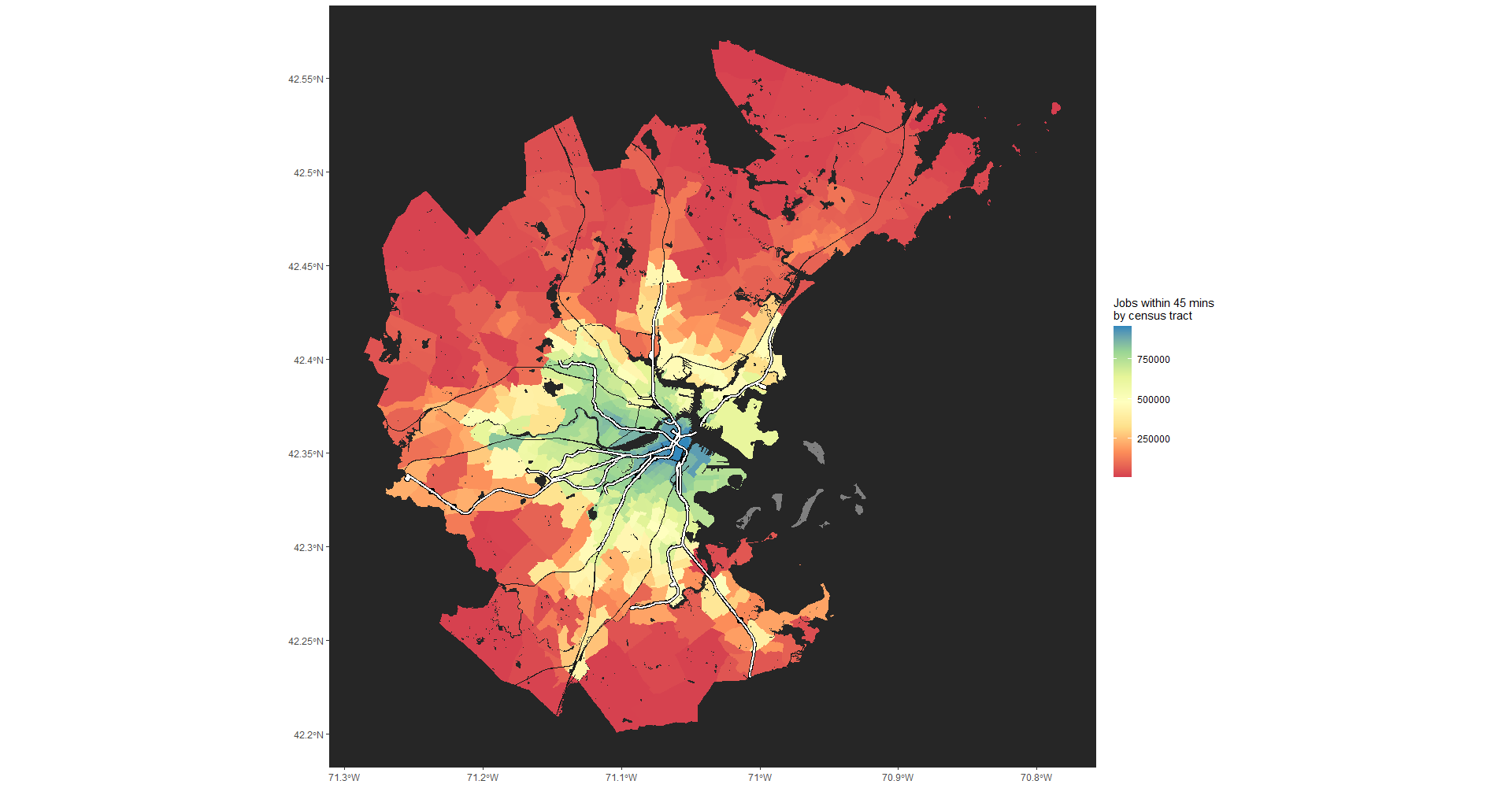
Commuter rail lines are in thin black lines, subway and light rail lines are in thick white lines. Buses are not shown but are included in people’s transportation modes. Departure time is treated as fixed – passengers have five randomly selected departure times in the period between 7:30 and 8:30, and access and waiting times are added to in-vehicle travel time. Better job access is in blue, grading through green and yellow into red where job access is the poorest.
Observe that the subway lines are surrounded by much greener census tracts than places farther out. In particular, the tracts around the Red Line, which heads from Downtown Boston to the south-southeast, and the tracts around the Orange Line, heading south-southwest, are a lot greener than areas in between the two lines. The point where the Red Lin appears to branch is an orange census tract, but that area has no station, and where the stations are, the tracts are a lot greener, underscoring the importance of the subway for job access. The Red Line then crosses into Cambridge, where the tracts are green-blue thanks to the concentration of jobs in that area, but again, the northwestern tail of the line is visibly green, while the northern end of the Orange Line is still yellow while farther-out regions are red.
Unfortunately, commuter rail mostly does not have the same effect, even at rush hour, when frequency is more reasonable than off-peak. There is some yellow around Readville, the rail junction station in the far south of the depicted area, where peak frequency is around 20-25 minutes, before dropping to worse than hourly midday, but by and large the commuter lines do not generate noticeably greener areas around their stations. The difference between the Red Line and the Fitchburg Line to the Northwest is the starkest, but it is not the only place. Where we do see more green around train stations, such as the tail of the Needham Line southwest of the end of the Orange Line, it’s often bus service connecting to the subway or express buses to Downtown Boston, rather than commuter rail service.
The Fairmount Line
The worst case seen on the map is that of the Fairmount Line, extending south of Downtown Boston between the Red and Orange Lines, terminating at Readville. It has poor service both peak and off-peak; when the MBTA recently announced that it would move to an all-day clockface schedule to improve off-peak headways, it gave the Fairmount Line 45-minute frequency all day, which is neither viable for urban trips nor clockface.
On the map, we can see how there is visible yellow and green on the Orange and Red Lines, but not so much along the Fairmount Line. Even at rush hour, job access there is not on a par with what the more frequent subway provides. Nor is the Fairmount Line good for providing access to the jobs most typical of the needs of the working-class neighborhoods it passes through:
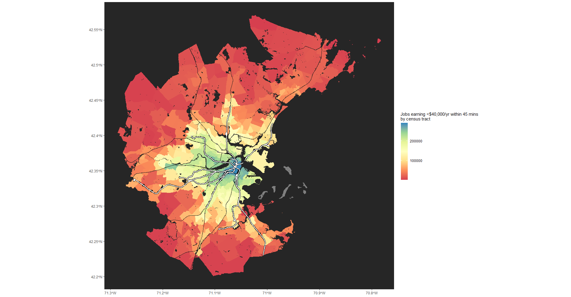
The color scheme is relative, so blue is better than red, but the absolute numbers differ. With this restriction, Cambridge is still green-blue – it is full of middle-class jobs but also working-class ones. And the Fairmount Line remains noticeably redder than both the Red and Orange Lines, because the frequency is so low that passengers wait too long for the trip to remain under the 45-minute line.
Captive riders are not captive to your line
American transit planners like to differentiate between choice riders, who can drive if public transportation isn’t good enough, and captive riders, who can’t. It’s a bad distinction and Jarrett Walker for example has been criticizing it for at least 11 years. Regardless, captive riders who have no alternative to public transportation do have an alternative to one specific line. If the Fairmount Line is bad, they will ride buses and have hour-long commutes, or walk long distances to the subway for same. As a result, the ridership of the Fairmount Line is very weak.
Between the idea of captive riders and the idea that commuter rail is only for the suburban middle class and isn’t really public transit, it’s not surprising why the people who manage the MBTA underserve the line. They hesitate to expand commuter rail beyond its suburban commuter niche, to the point of thinking 45-minute frequencies are good service. Nor do they think in terms of alternatives – captive riders are not supposed to have them, so the idea that they can just ride something else is not usually part of how American transit planners do business analysis.
With such hesitation, they rely on government-by-pilot-program to test new ideas. But all pilots are doomed to failure when the Orange Line runs every 6 minutes and the Red Line’s Ashmont branch every 9. Small increases in service do not lead to high ridership, because riders can still more easily ride a bus or the subway, and this will not change until Fairmount Line frequency is raised to near-urban levels, at worst every 20 minutes, more likely every 7.5 or every 10. Until this happens, commutes in Mattapan and the western parts of Dorchester will remain very long and job access will be poor.

As a corollary to this, if you look at population distribution of downtown workers, they tend to disproportionately work near subway not commuter lines in US Cities. It’s part of the reason why Loop Worker density is so much higher near the northern Blue and Red Line in Chicago than elsewhere, and why there are way more SF downtown workers in the East Bay than in Santa Clara County.
Caltrain doesn’t even get to Downtown SF… but even when a commuter line does – South Station actually beats Downtown Crossing and Park Street on jobs within 0.5 miles – its ridership lags.
Why even build a subway parallel to commuter rail line when it’s possible to electrify and double track the commuter rail line, add stations, and run the line at subway-level frequency?
Because you live in America, where mainline railroaders kill all good commuter rail projects.
Well put…
In SF, we could have electrified the Capitol Corridor rail line and had spur tunnel for trains to run into the bay instead of building BART.
In LA, we could have electrified San Bernardino Line instead of building the Gold Line Foothill/Claremont extensions.
Sigh…
@Ryland L.
“In SF, we could have electrified the Capitol Corridor rail line and had spur tunnel for trains to run into the bay instead of building BART.”
Correct, but I’d phrase it slightly differently. The creators of BART proposed exactly that, which would have involved electrifying the line and removing all the ground road crossings. But, as you say, Santa Clara county which happened to have a significant share of the peninsula Caltrain ROW and thus a veto vote, refused. Probably because it implied a funding contribution and inevitably tax increases or bond issues or all their voters exclusively drove cars etc. So BART had to build their sub-optimal system. But if it had gone ahead it wouldn’t have been instead of building BART, it would have become BART.
I’m talking about east Bay, not the peninsula
In Oakland and Berkeley the BART ROW is much more useful than Capital Corridor, and the Berkeley Hills branch is also worth something. Not to mention San Francisco and the Transbay tunnel which are probably the most expensive parts of the system. But yes substantial parts of the system, particularly in the South Bay, are superfluous.
The BART and Cap Corridor lines run awfully close together much of the way in Oakland.
Could have just a spur tunnel/elevated segment from DT Oakland to Richmond via DT Berkeley and Albany to construct.
Also the Cap Corridor alignment is in some ways, better on approach to San Jose (misses Milpitas, but captures Oracle/HP headquarters area).
Gotta think like the Japanese and Koreans here.
If the rail line doesn’t go the whole way, we can just have subway spurs feeding into/branching off it rather than construct a whole new subway!
The capital corridor line didn’t reach that many stops in Contra Costa County or Alameda County, so some new building was required.
No they didn’t.
Do you just enjoy typing meaningless words? What’s the point?
It should still be cheaper for local governments to buy existing rails for passenger operation than building new?
possible to see which mode provides good access and which doesn’t:
People who live closer to work have shorter commutes. Who woulda thunk?
possible to see which mode provides good access and which doesn’t:
I’m not in the mood to go ferret out a current American Community Survey. Last time I looked at Rockland County New York because foamer boyz were getting in a froth about sending trains from Suffern to Rye because so many Rocklanders work in Westchester…. they don’t. The great majority of people in Rockland County work in Rockland County. The ones who do commute out of the county don’t commute to Westchester much. I still want to know what is in Mount Kisco that is so compelling would leave Danbury for it, much less get the urge to use a train to do it.
Very likely the same kind of thing for the outer suburbs of anywhere. There are other ways to make a living besides manipulating symbols in a downtown office building. Many many suburban symbol manipulators do it in suburban offices. Imagine that. typing in an office somewhere where there aren’t any trains. And there are wide swaths of working people who don’t do much typing! ! ! ! I
What was the point of this comment? To say job sprawl is a thing? To point out people tend to live close to where they work? Alon’s post specifically focused on the Fairmont line which mostly runs in Boston, and at roughly the same distances as the Red and Orange Lines. The fact that commuter rail does a terrible job for a bunch of poor and working class people in that area seems like an important thing to quantify.
“I enjoy typing. Typing is fun.”
The title of the post is “American Commuter Rail and Job Access” not “The Fairmont line”.
The first sentence has “”….poking around frequency and job access in New York and Boston”. Rockland County is a suburb of New York City because the most popular place for Rockland County residents to commute to is New York County a.k.a. Manhattan. Which they have had rail access, lousy access but access, since the 1850s.
I’m not sure what his definition of working class is but I have a feeling most of the jobs don’t have a typing speed requirement. There aren’t a lot of them in tall office buildings downtown. Or even short office buildings.
adirondacker12800 only reads the first line confirmed.
There are tons of working class jobs in downtowns. If you ever look at say working class census tracts on the south or southwest sides of Chicago you find around 20% of them work downtown. I suspect it’s much the same in Queens or the Bronx.
And I don’t understand your fixation on Rockland County. There are many closer in places to US cities served by commuter rail with better alignments than it.
Because that’s what I remember from the last ACS I looked it. Feel free to go find a current one. It had other interesting things in like there are people who commute from Albany county New York to Oahu in Hawaii. And even more who commute to Los Angeles County, California.
Yes the rich people working in glittery office buildings expect there to be janitors and cashiers in Walgreens. And the pink collar jobs usually need a typing speed of 35 or 40 WPM. If 20 percent of them are going downtown that implies 80 percent of them aren’t. I bet a few of them run the cash register in the local Walgreens or Burger King or make appointment for the local dentist/doctor and needed to type 35 WPM to get the job.
I let my wheezy old computer and Libre Office churn through the ancient ACS .xlsx file I ferreted out of the Census Bureau’s website years ago. At the time the Census Bureau estimated that 232,832 Bronx residents worked in Bronx County. 193,345 of them worked in New York County a.k.a. Manhattan. It’s higher than 20 percent. I didn’t look at Queens or Brooklyn.
1. Srsly, their, not his.
2. LEHD’s income buckets are coarse so the best we have is $40,000/year as a cutoff.
3. Yes, the CBD concentration of jobs is weaker below the cutoff than above it, but it’s still there, hence the access map for such jobs.
4. The New York poking around didn’t go far into the suburbs, it was within the city. It’s not as stark as in Boston because the commuter lines mostly follow the same alignments as the subway, but you can see how much access craters past the ends of the subway, and how much better it is if you run the same code but pretend the commuter rail schedule is a frequent takt and not what the nice white flighters of Long Island think Queens deserves.
Whose? Yours? Yours and Uday’s? If there are more than two of you, all of you?
Not that English has any logic to it
but it’s, with an apostrophe because that is a contraction of “it is”, he:his, she:hers, it:its, without an apostrophe because his and hers don’t have have one. Neither does we/us:ours. I come up with theys. Or perhaps theyz. Yer gonna make third graders cry. We have, there, their and they’re. I could do that with a colon and semi-colons but decided not. They save what to do about the Jones family until fourth grade. I’m leaning towards ye:yiz. Yers is colloquial. Dastardly German type makers not giving us a thorn symbol gets mixed in with it all.
I worked with payroll for years. My typing skills were handy but being able to use a comptometer was more useful. This hadn’t occurred to me. 80 hours a week at straight time, which ever way the household wants to slice that, is below Massachusetts minimum wage if it’s below 40k. What’s the percentage of people in the workforce might be an interesting question too. And household size and family size etc.
….weird peculiar things can happen.
https://en.wikipedia.org/wiki/Dannemora_(village),_New_York#Demographics
Take your bigotry somewhere else, please.
Speak of which, one think about captive passengers being able to use alternative mode could be turned against passengers by transportation authorities
For example, if a city build an underperforming subway line, and then they discovered that many passengers who’d be riding the subway opt to use like express coach service for direct access into city center with similar travel time and saving a transfer via feeder bus, those cities could come up with excuses like “reduce congestion” or “increase subway ridership” to forcefully terminate those more convenient services, in order to force people use the underperforming subway line so that they look nice on policy chart but only make public transit more inconvenient and swing those who have the ability to choose to go back to using automobiles
This exact scenario has played out many times in the San Francisco California area.
In particular, the castastophic BART extensions from Daly City to Colma and eventually Millbrae essentially lead to the service bankruptcy of SamTrans, the San Mateo County transportation operating agency, the decimination of local buses, the progressive cut-backs in route length — first to hopelessly under-performing BART extension stations, then to zero — and route frequency of both local and regional bus lines.
Exactly as was predicted by anybody who wasn’t on take from the engineering consultancies and contractors who promoted and profited from it.
At a city local level, the disastrously bad SF Muni “light” rail line replacing buses on Third Street also haemorraghed riders as the bus it “replaced” was faster, more reliable, and more direct. The rail line, again, was purely about contractor profits. Muni is, in fact, planning to reinstate bus routes in the corridor, tacitly admitting that the $650 million wasted on the rail line was, well, wasted. “Mistakes were made (… and we’re going to make the same ones again, forever and ever.)”
SF Muni’s about-to-open catastrophically expensive and inutilte “New Central Subway” is coming complete with plenty of bus cutbacks, negative ridership, and worse service. A one-station rail extension, in effect, for a price tag well over $1/6 billion. All because a mile of mixed traffic traffic lanes “couldn’t” be converted to exclusive bus lanes.
It’s a beautiful planet we live on.
Rail generally out performs buses when it comes to ridership even if there are some exceptions. So investing in rail, which is also easier to use as a development base generally makes sense. Buses are thinks that technocrats and activists like that most users generally avoid. So generally the choice for transit users is rail over bus in most circumstances.
Thanks for sharing! Nobody ever thought of any of that before. I’ll have to carefully reconsider everything I’ve ever seen with my own eyes in light of these insights.
Rio de Janeiro built three light rail lines (with plans for more) to replace intra-city-centre buses in the 2010s and they’re extremely popular, to the point that the only people who ever complain about them are the sort of people who wish the city was frozen in amber around 1980. Conversely, three BRT lines were simultaneously built further out in the city to connect northern and western suburbs to a secondary city centre, and two of the BRT lines immediately got horribly overcrowded and unpopular and are avoided as much as possible.
(I killed a duplicate.)
“and two of the BRT lines immediately got horribly overcrowded and unpopular and are avoided as much as possible” – so nobody goes there any more because they are too crowed, eh?
“overcrowded and unpopular and are avoided as much as possible.”
Nobody goes there anymore, it’s too crowded 🙂
BTW Rio is not exactly a model for good transportation planning, or any sort of planning, really.
The comment here was the duplicate, I meant to put the above comment in the subthread below this one 😡
Rio’s BRT being overcrowded means that the quality of transport is terrible, and making people have to suffer in those conditions is morally bad. It also means that there’s a lot of *potential* passengers who are being lost because they just straight-up can’t fit onto existing transport corridors (even though they would with metro lines), which, yes, suppresses demand.
also I didn’t realize 😡 makes an angry face
I agree that long distance travel in Rio should ideally be done by metro or commuter rail, not bus. That said, the crowdedness of this BRT route indicates that it’s better than what previously came before it. Also, the downtown LRTs, while popular, only serve a tiny fraction of the region’s population and probably a disproportionately rich fraction. The best outcome would have been to take the BRT and LRT money and use it to build (non-tunneled) metro rather than BRT on a current BRT route.
Rich people in Rio don’t live in the city centre, they (usually) live in the South side or Greater Barra da Tijuca. The light rail itself is there not so much to serve the population of the city centre itself but to serve people who go *to* the city centre (e.g. people who take a train to Central can change onto the light rail to go to Candelária/Carioca/Cinelândia/etc.)
Buses also struggle to be time competitive with driving as they are almost always slower
That’s another issue but the main thing is that the bulk of transit users, outside some exceptions, prefer rail over buses for a variety of reasons even if there isn’t much benefit in terms of time.
It’s Original Insight Week here at Only the Very Most Pedestrian of all Possible Observations dot com.
I do not get the obsession with buses from wonks and activists when it is very clear that many do not like buses. Politicians literally need to punish people out of their cars in order to get most people to consider buses. Yet, we have people that consistently advocate for them no matter what even though rail is the best way to get people to use transit.
So here’s a great article I recently saw on buses vs LRT (this Alex Danco works in tech startups in Toronto). It shows how high-frequency bus lines in Toronto get ridership comparable to LRT, and are much more socially equitable, because they can be run everywhere for the same price that LRT can be built on one or two corridors inhabited by rich people.
Quote: “It turns out when people say they don’t like taking the bus, what they really don’t like isn’t the bus itself, but mostly bus schedules that are unreliable or infrequent. High frequency, prioritized bus service is actually quite popular when done right.”
Sure, LRT is more comfortable than bus and that leads to marginally more riders, but not in proportion to the investment needed.
Toronto’s buses work as subway feeders, it’s hardly a buses-work-as-well-as-rail case. In particular, that last drawing pooh-poohing rapid transit for only serving the rich is completely bunk: Toronto is not a single-mode city, and the rest of the piece even mentions transfers in between the bullshit anti-urban culture war rant.
The last drawing should have said “light rail” rather than “rapid transit”. Other than that, I don’t see a single wrong thing in the article.
The last drawing is wrong regardless of labels. The single-mode surface system is too slow to serve city center, and Toronto doesn’t work that way – it has a hierarchy of rail and buses in which buses are a feeder. The same notional drawing is also Berlin’s problem, except here the slow surface mode is trams and the fast mode the Greens and Linke think immoral is the subway.
More things that are wrong:
1. High wealth in near-center neighborhoods doesn’t live off of the subway (or light rail), but off of shorter commutes.
2. In the American cities the post compares Toronto positively with, transit commuters are a lot poorer than drivers – and in LA, rail riders are pretty poor as well, if not so much as bus riders. The problem with LA isn’t that light rail serves the rich (South Central isn’t rich), it’s that it is still bad so only poor people ride transit.
3. Also on the subject of LA, it matters that the average light rail line there, including lolfests like the Green Line, has higher ridership than every single Toronto bus.
4. By New York standards, Toronto’s bus ridership is unremarkable. New York’s busiest buses are (slightly) busier than Toronto’s, and the median frequency for a Brooklyn bus is 12 minutes, with a lot of 10-minute routes. Both cities heavily rely on bus-rail transfers – and nobody in their right mind in New York would treat buses as subway-equivalent. Ditto Vancouver and buses vs. SkyTrain, and in fact the top bus corridor in Vancouver is being replaced by a subway.
5. Building a strong white-collar downtown core off of a radial subway is if anything a good thing for socioeconomic equality, because it lessens the importance of directionality, which drives long commute times for the working class in cities with job sprawl.
6. Toronto had a proposal for light rail, which sucked in many ways, but “only serves the middle class” was not one of them.
@Eric2, preferring buses to rail transit because it is socially equitable is no way to get people out of their cars. Especially in developed democracies where the majority of the population lives above the poverty line. You can have transit as a general transportation service that everybody uses it or you can run at as a social service for the poor but you can’t do both. Running transit as a social service for the poor results in poor transit services that nobody uses as Alon points. It ends up being an after thought at best. Services for the poor tend to be poor.
0) “The single-mode surface system is too slow to serve city center, and Toronto doesn’t work that way” – true for Toronto, not true for most US cities where the alternatives are LRT or high frequency bus
1) Whenever a LRT line is built, there are comments about how many billions of dollars of development the route has induced. If development is happening on the LRT route more than elsewhere, that’s because there is more profit to be made, generally from a wealthier population, than elsewhere.
2) Rail riders are richer than bus riders in most US cities. LA is an outlier in many ways.
3) Those LA light rail lines have extensive grade separations (Green Line is fully grade separated) while Toronto buses have no grade separation. Also, LA light rail lines were super-expensive to build, and cover little of the metro area. The whole point of the article is that even though light rail is somewhat better than buses on a single route, you can have high quality buses on many routes and get better service overall.
4) NYC is more than twice as dense as Toronto (municipal boundaries in each case) – if ridership is only slightly higher, that’s a disappointment.
4a) To repeat myself, the article did not say buses are subway-equivalent, it said buses are (nearly) LRT-equivalent.
5) See 4a
6) Not sure what this is supposed to prove
0. Okay, but the “buses work in Toronto” point is specific to Toronto. Buses in Los Angeles for example do not work. In fact every North American example of transit share retention, even the American ones (Portland, Seattle), involve rail as a spine, and not a purely bus-based system.
1. That’s rhetoric; I’m talking about reality. Same way every developer tells you their new building is luxury.
2. Rail riders are richer than bus riders in LA too, but they’re poorer than drivers.
3. The Blue Line wasn’t particularly expensive. The Green Line is a sop to activists who sued over the Century Freeway.
4. New York has higher metropolitan transit modal split than Toronto, the “slightly higher” is ridership on the busiest bus, not overall bus ridership.
5. No they’re not and in Toronto-size cities with an intact CBD you see higher tramway ridership when that is available (hi, Berlin).
6. The idea that light rail only serves rich area is unrecognizable when you know which neighborhoods Transit City was going to serve.
Most of my planning professors (at an unnamed planning school in California) who talked about transit were of the opinion that “a well-patronized bus>> fancy light rail” yada yada yada. Always thought that view was a tad simplistic but it has the policy makers’ ear.
I think biggest issue is American light rail and regional rail projects tend to be so poorly planned (and overpriced) as to not be worth the cost from a short-term perspective
Are American bus projects well-planned and with low prices?
@RynardL, the issue is getting the bus to be well-patronized. So far it seems that to be really hard in the United States at least. Given the choice between driving and a bus, most Americans go for driving.
The problem is LRT construction gets federal funding but bus operations do not. So inefficient LRT lines get built because it’s someone else’s tax money after all.
No, but even when they fuck up
(a) the public is several BILLION dollars better off than with a guaranteed-fucked-up rail project; and
(b) insurmountable obstacles to useable future projects (undertaken by a race of superintelligent enlightened aliens, not anybody we know) aren’t permanently precluded.
I give you the San Francisco Transbay Terminal and Caltrain extension as a catastrophic example: if would be infinitely better for this $2 billion (with well over another $2 billion or more for the actual train extension and tunnels they “couldn’t afford”) pile of shit to never have been built, firstly because, you know, $2 billion dollars for nothing, and mostly because structural columns for the $2 billion edifice are placed exactly where the trains need to run and where and escalators for humans needed to go.
Meanwhile San Francisco is undertaking scores of bus priority projects. Some of them are OK! (None of them cost anything remotely reasonable, but we’re talking US “public” agencies and US “public” works here, and hey, we’re talking 10^5-10^6 dollar quanitities, not 10^9-10^10) Some of them — Van Ness Avenue bus lanes, most of $300 million pissed away on add-on pork, years late — are awful, but don’t make things worse.
It’s not just San Francisco. Almost without exception you’ll find anything Amtrak’s doing in North East Corridor is worse than doing nothing. Everything California High Speed Rail is doing is worse than nothing.
Even America’s Finest Transportation Planning Professionals just can’t fuck up that much with some lane dedication here, a bus-exclusive bridge there, etc. They just can’t, and God only knows they try. For catastrophic projects you’re going to have to look at choo-choo trains and highways. Urban and regional bus boondoggles aren’t even a rounding error.
Order of magnitude, people, order of magnitude. The number of trailing zeroes means something.
Almost without exception you’ll find anything Amtrak’s doing in North East Corridor is worse than doing nothing.
They haven’t had money to do much of anything except replace things that are falling apart in a long time. Replacing the parts that are falling apart has some value.
New tunnels for Baltimore, that are a lot faster, completing that before the old tunnel collapses, again, would be nice. They have final approvals for that but haven’t found the money.
The new bridge over the Hackensack River, that doesn’t open for river traffic, like the old one, will be good. It will speed things up by minutes once it’s paired with another bridge and new tunnels to Manhattan. Until then it still speeds things up but not by as much. They just got funding commitments for that a few months ago. It’s pricey but it works out to $9 a passenger.
The WPA got it’s money’s worth for the electrification they paid for in the 30s. It was very nice of the yokels in the hinterlands to turn down all that money back in 2009 and 2010. They rebuilt 20 percent of the route between New York City and Washington D.C. with that, along with some other things that aren’t in the headlines. It’s likely higher than 20 percent of the track distance because it’s in the four track section.
It’s just awful how NJTransit runs electric commuter trains at 100mph on it. To stations with level boarding and are otherwise ADA compliant. Terrible. With 1,000 or more seats. Truly awful. Pitiful that they miss out on diesel fumes, the festive grade crossing lights and bells and clambering up and down stairs from the platform to the car.
The bus service from my home to certain CBD take 25 minutes, with 3 minutes headway in peak hour, as it mostly travel through expressway. Usually little to no congestion even in the peak hour
The neighboring metro service have a headway of 1.5 minutes and need 30 minutes to reach the destination, and to use it I would need to take a feeder bus with 12 minutes journey time and a 40 second headway, in addition to an extra 10 minutes queue in rush hour at the feeder bus stop. It would also take an extra 5 minutes time combined to enter and exit the metro service platform at both ends and reach surface street.
What benefit could I gain if the transportation authority decided to cut the direct bus and instead favor connection tthrough metro rail?
In your case, it would be lose-lose not only for you or customer but also for the entire corridor given very high service level (bus in 3 minute headway and train in 1.5 minute headway) because by taking away bus service at such high frequency, it would make the congestion on the train (in 90 second frequency) significantly worse. It sounds like the city could have done something else (e.g. make an investment into higher-capacity transit system like subway) before increasing the bus service to such high frequency or to realign to the expressway, but they just built the subway as some sorts of afterthought.
What we need is ways to prevent “city [from] build an underperforming subway line” by hiring competent engineers, planners and decision-makers, make them review the work done by outside consultants thoroughly and properly before making decisions even if they ended up with hiring consultants (reviewing part appears to be hugely missing in North American transportation planning), and depoliticize the planning and decision-making process.
Not a fan of express buses as a transport mode, though. They are only useful for downtown commutes (or whatever the destination of the express is), and are usually very peak heavy, catering principally to 9-5ers rather than people with complex transport needs.
A feeder bus interchanging with a metro/commuter rail line (even a rail line with regular stops can be as fast as an express bus service that still has to negotiate traffic, cross-streets etc) serves a much wider variety of transport functions and can ween people off cars entirely. Express buses can get your to your office job every morning but little else.
I’d be interested in Alon’s thoughts. Express buses rarely seem to figure into transit proposals on this blog (and also aren’t much of a feature in good transit countries like Switzerland, Holland, Germany; although I have no idea what the situation is in Japan).
New York’s express buses are in might-as-well-not-exist category. They exist because people with a strong not-like-the-rest-of-the-city political identity ride them, at very high subsidy rates, and their resources should be redistributed to more (and faster) local buses and subways.
In general, modes of transit that live off fare disintegration are bad, regardless of whether those are premium express buses as in New York, or buses that are priced below the subway as in Washington.
The only good reason I can see for a premium fare on any mode is if the mode is at the highest capacity it can reasonably reach, is still overloaded (or would be without the fare premium) and there is an alternative mode which can carry the excess passengers.
If you’re running 40 second headways on a subway and the trains are limited by platform length, and are still leaving people behind because of overcrowding, and you’re running parallel buses that are not crowded because they take so long to get through road congestion, then pricing people off the subway and onto the bus may be necessary. It sucks that you have to do it, but at that point, your only other option is another subway line – and even assuming you have the ability to build one, it still takes years to build.
But this should be recognised as a temporary measure until you can get enough capacity for everyone. It’s not a road, it is possible to provide enough capacity even with induced demand, so you don’t need a permanent pricing scheme.
Pricing people out of using the subway reduces their freedom of movement, even if the subway is *that* overcrowded. Better solutions would be to implement dedicated bus lanes on the roads to have the buses move quicker, build separate cycle lanes, build good pedestrian infrastructure, etc.
How do you define a mode as live off fare disintegration? I think it make sense for a mode that have different cost base to charge passengers differently, for instance for an express bus to charge more than regular bus due to the fee of using expressway
Express buses can be a lifesaver in Rio de Janeiro, but they’re operating under some pretty ideal conditions: Spotty rail coverage, with a lot of that rail being run very badly, and a fare structure that often prices them the same as local buses while making it expensive to change modes.
Taipei has several suburbs (notably Sanxia and Linkou) that are almost entirely reliant on express buses for transit. Linkou now has rail, and Sanxia will in a few years, but they are both fairly slow metro lines that don’t offer the convenience of a bus that provides a one-seat ride into the city center. Rail could probably outcompete buses there if Taiwan could figure out regional rail, but we haven’t and so it couldn’t.
One difference is that Taiwan’s express buses are almost certainly not subsidized to the same degree. And are they really that much faster at rush hour? Sure you’ll be facing a lot of stops if you take the future Sanxia line to Taipei, but at least you don’t have to deal with congestion on the freeways.
Also the Airport Line does provide 1 seat access to a reasonable number of jobs- the Taipei Main area and Wugu both have a fair amount of employment. The main problem there is the horrible transfer at Taipei Main, and the government-encouraged diffusion of jobs to eastern edges of the Taipei Basin, far from where most of people live.
What’s tragic is that Taiwan’s lack of self respect leads it to learn from other countries, which we assume is good, but whereas Italy or South Korea seem to take the best lessons from Germany and Japan, Taiwan seems to take the worst lessons from Hong Kong and the US.
It depends on topology of your city. And what sort of infrastructure you have. If your district is separated from the city core by a mountain, and is connected directly by an expressway, there are nothing wrong to provide an express bus connection directly linking your district into the city core, and then further use interchange options to connect toward rest of the city. In some case even if you can build a rail along the way, due to things like alignment and time spent on stops, the bus will still have competitive advantage over the rail.
There’s an example of direct competition between express buses & rail in the Washington DC suburbs. Express bus in rush hour takes HOV lanes from northern Montgomery County to the inner-suburban Medical Center & Bethesda stations on the Red Line. Ridership is minuscule compared to local bus transfers to Red Line at its Shady Grove terminus. Bus use is almost exclusively to jobs at Medical Center & Bethesda.
If you’re going to Red Line stations in DC, taking the express bus & transferring to the train at Medical Center is both faster and cheaper than taking the local bus & transferring at Shady Grove. Yet my observation passing out leaflets at Medical Center is that almost no one transfers from the express bus to the train there.
Probably the express bus has low frequency and therefore can’t be relied upon?
I’d expect the area around the northern tail of the Orange line to get “greener” as redevelopment continues around Assembly, Sullivan, and to some extent Wellington.
RE: captive riders – 13 different MBTA bus routes that run between the Red & Orange lines in Boston also include a stop at a Fairmount line station in between them. This includes 4 of the 15 “Key Bus Routes” system-wide. Fairmount frequency improvements (along with the Red-Blue connector and a Sullivan-West Station light rail service) ought to be pitched as a concerted Program to relieve congestion, and the consequential station dwell times, on the Red and Orange lines downtown. Downtown congestion relief is a significant factor in federal funding calculus, iirc.
As an aside, I personally don’t understand why red to green is so common as a scale for visualizations, but maybe that’s because I can’t see it.
It’s red to green to blue. The rainbow. Probably the easiest spectrum to grasp with the highest number of intuitive midpoints.
It is bad for the colorblind though.
For the record, I am colorblind.
Red-green colorblindness is the most common form, and colorblindness is fairly common (1 in 8 men, 1 in 200 women). It’s pretty much table stakes for data visualization, since all you have to do is pick a different color, and there are entire websites dedicated to finding accessible palettes.
Yes, it was a bit late when I realized what you were getting at. I see a lot of visualizations online that are pretty bad for non-color-blind people, and wonder what could possess them to use such a bad spectrum. Perhaps the reason is that all the “good” spectrums are bad for the color-blind.
Transit agencies can differentiate between shades to help with this, e.g. dark red-lime green, or dark green-pink.
My impression also is that parallel lines (e.g. for routes that share the same track) is a lot more of a problem in this regard than intersecting lines, unless the intersection is counter-intuitive, i.e. if a line makes a sharp turn at the intersecting point.
^ You’ve changed the subject from data spectrum colors to route map colors (also interesting).
I think color-seeing humans (at least in Western cultures) can easily distinguish only about 11 colors: red, orange, yellow, green, teal, blue, purple, pink, brown, grey, black. Not coincidentally most systems limit themselves to these colors. NYC Subway has 20 or so lines, but lines that run together in Manhattan share a color, so there are only 11 colors overall (no teal; the 11th is light green for the G). London adds light green (Waterloo & City) for a total of 12 (including Overground). Hong Kong has two purple lines for some reason, but an expansion soon should fix that. To me Paris is the outlier with a horrible palette of obscure and overlapping colors. Partly that is because the good colors were reserved for the RER, partly due to I think unforced errors (for example, lines 8/9 could share a color, as could 1/A and 4/B, and all the colors seem more obscure then needed).
As for color-blind people, I imagine these 11 colors are far too many to distinguish (though do color-blind people get better at distinguishing the colors they can see, or else greyscales?) and maps need to include route numbers as well as colors for their benefit.
Getting back to data spectrum colors, here is an interesting academic paper which recommends against rainbows.
There was a subway map where each line had it’s own separate color.
https://www.nycurbanism.com/map-store/1972-vignelli-subway-map
I am not sure you want to share colours on 1/A and 4/B, as these are some of the lines it’s *most* important for users to distinguish between – they serve similar routes intra-muros but in very different ways. And you can milk the spectrum for far more colours than that, even if you don’t have easy names for them all (which is only required if there’s no letters/numbers/names to easily distinguish them otherwise).
Psych 101 is that humans can more or less keep seven (plus or minus two, depending on the person) in short term memory.
Most of the changes in clarity that New Yorkers positively associate with the more geographic map that replaced Vignelli I would imagine are actually the reduction from 20+ colors to about 9 colors, with only 5 colors for the big trunk routes. The MTA hasn’t totally abandoned the Vignelli though; it gets used (with the modern color scheme) for weekend service changes, and was spotted testing it in public last year: https://nypost.com/2020/07/29/mta-testing-subway-map-makeover-at-brooklyn-station/
As far as colorblindness in maps, mine isn’t that severe, and the problems are only really apparent when the problematic colors are next to each other. The IRT is pretty bad in this regard, with the red 2/3 often next to the green 4/5. but at least on the map there are never any janky intersections that would make it very confusing, and in the context of signage the other uniquely identifying feature, the number, is so large I can just use that.
@fjod
“these are some of the lines it’s *most* important for users to distinguish between” – I presume the map already distinguishes between RER and metro in a manner other than color. These route pairs run in parallel with each other sharing stops, similar to local and express lines in NYC. NYC puts local/express in the same color and I think it makes sense here too. The Paris metro is beyond confusing, and I think this would increase people’s understanding.
“you can milk the spectrum for far more colours than that” – At least for me, it helps a lot if I can easily assign a name to the color I am trying to follow.
@Henry
I think this is a different issue. You don’t actually need to keep track of many colors at once – just one color for the current trip and one for a possible transfer, I would think. Then, when imagining an alternate route, it’s a different two colors. But you do need to easily distinguish those colors from every single other color on the map which they cross.
@Eric2: The 72 Vignelli map had only two ways of identifying a route; the color, and the route letters below stops in very small font. Given that you can’t really read the letters in the printed form unless your face is pretty much against the map, color is the only other way to identify, at which point you’re trying to figure out which shade is which route. And this is before you get into the intricacies of printing, where color bleeding or being slightly off is not that uncommon of a problem.
The modern color scheme is very striking and fairly high contrast, so it’s easier to narrow things down quickly. The bullets with the letters along the route lines also help, since those are much bigger font than the station names in the modern map.
@jcranmer: personally I like schemes that go from white for 0 to the darkest tone of the chosen color for 100.
Maps can be deceiving. Look at a geographically accurate map of election results it lies. This one is better.
There are ones that are even more accurate and detailed. The distortion gets worse and since it has more detail
big blue blobs are separated by bands of purple with thin red lines in the middle.
Or give this one a whirl. Half the people in the U.S. live in the highlighted counties.
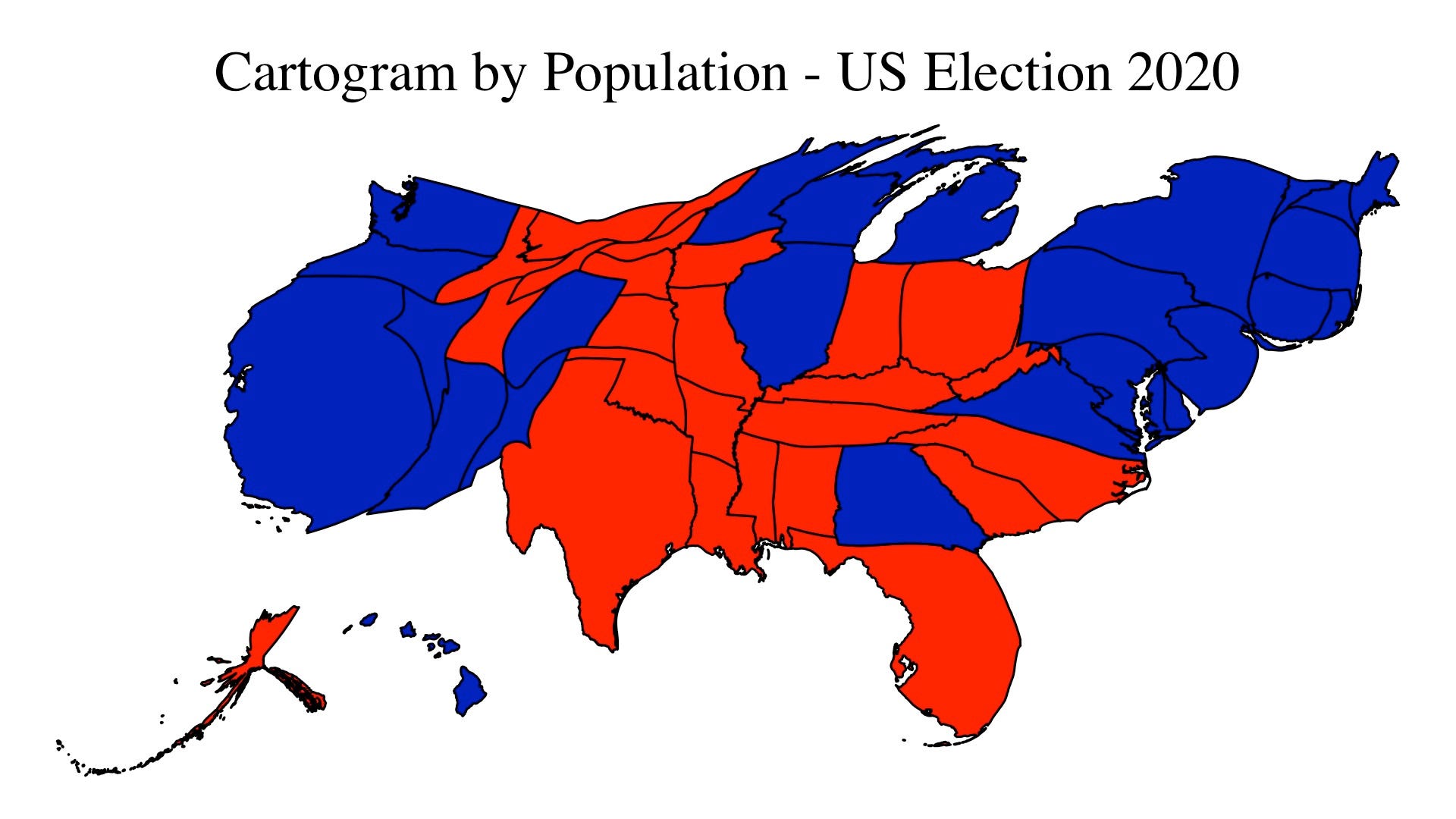
Ack pasted the same URL. Half of the us population
https://i.insider.com/5227a78e6bb3f70f68316148?width=700&format=jpeg&auto=webp
@Eric2 It might as well not (the one difference is in the symbol for the non-transferring stations) but the main problem is transfers: most of the time you *really* don’t want as a line 1 user to get on line A by mistake. Or as a line A user if going to Auber. And given that some of the transferring stations are amongst the most sprawling (e.g. Chatelet), I think it’s a good idea for RATP to disambiguate quickly and often for that kind of duos. Also, I’m pretty sure that’s not a question of the good colours being taken for the RER: the one colour the RER uses and the Métro doesn’t is red. The other four are shared…well, almost so for E’s fuschia.
I’ve commonly seen it mentioned in data science that the standard rainbow visualization is among the *worst* possible scheme to use. In addition to being next to useless for color-blind people, it has a strong tendency to leave visual artifacts, especially because many iterations of it don’t balance perceptive luminosity. (Print it out in grayscale, and it’s completely useless).
The reason why it’s most commonly used is probably because it was the default, so many people got used to it and ignored the issues. More modern visualization packages have generally switched away from rainbow scales as default to better color scales.
Alon’s scheme here doesn’t appear to be a traditional rainbow, but a diverging color scheme, with the median set to be a soft yellow and the low and high extremes a red and blue-green, respectively. On Color Brewer, this is roughly the Spectral diverging color scheme; I don’t think a diverging scheme is best here; I’d be somewhat more partial to a burgundy-based sequential line, but I’d have to tweak the color scheme to figure out which is the most aesthetically pleasing. I suspect the choice to use the diverging scheme may be to evoke a red-is-bad-green-is-good correlation, but I’m not sure that’s tenable if you can’t tie it to an absolute scale (e.g., 0%-to-100% code coverage).