How Tramway Networks Look
I’ve been thinking about trams today. The origin of this post is that yesterday’s post about modal versus other questions concerning public transport led to a conversation about how in some places, namely Vancouver, the light rail versus subway debate is big. And that got me thinking about how cities that do not have subways arrange their streetcar networks. These cities exist, mostly in Central and Eastern Europe, and often have very strong public transport – this is for example the Zurich model, based on a combination of streetcars and an S-Bahn system. Some such cities don’t even have an S-Bahn system. How do they arrange their tramway networks?
The top tram cities
I asked on Twitter what the busiest tramway network is in cities without a subway. Across all cities, including ones that have both streetcars and metro tunnels, the answer was Saint Petersburg at the beginning of the 21st century, and today is either still Saint Petersburg, where ridership has been in decline recently, or Budapest; Prague is the third. All have around 400 million annual riders, or somewhat less.
Among cities without subways, it’s harder to tell, because the information isn’t always out there; streetcars are not as well-studied as subways, a pattern of which I am guilty of contributing to with the focus of the Transit Costs Project (for now). Zurich, Brno, Zagreb, and Melbourne all have around 200 million annual passengers each, and Bratislava, Kraków, Łódź, an Belgrade are all plausible contenders except that I have not been able to find ridership figures for them.
Additional cities with strong ridership but not 200 million a year include the Upper Silesia complex with about 100 million, which is weak for its size with high car modal split for a Polish city, and smaller cities like Leipzig, Dresden, Linz, Basel, Geneva, Košice, Gothenburg and Lviv.
The pattern of tram cities
All of the high-ridership tram cities I’ve been able to find have historically maintained their systems. Cities that closed their streetcars in the postwar era and have since reopened them as modern light rail systems sometimes have very strong ridership, like Paris, but that’s in conjunction with a metro system; the Ile-de-France tram network is strikingly circumferential and barely penetrates city limits, where the Métro predominates. In the United States, the busiest modern light rail system is Los Angeles and the busiest without a subway is Portland, with 40 million annual trips, in a metro area of comparable size to Upper Silesia, which is much more auto-oriented than monocentric Polish city regions like those of Warsaw and Kraków.
Moreover, nearly all examples I know are in Central and Eastern Europe. Elsewhere, trams were shut down in the postwar era, or replaced with subway-surface Stadtbahn systems as in San Francisco and most West German cities. This is going to color the analysis, because just as there are American, Soviet, British, French, and German traditions of how to build rapid transit, there are national and areal traditions of how to build tramways, and with the exceptions of Melbourne and Gothenburg, all of the top systems in metro-free cities are in one or two macro-regions (Warsaw Pact and German), which means that shared features may be either the key to success or just a regional cultural feature.
The shape of strong tramway networks
I encourage readers to go to Alexander Rapp’s website with maps of rapid transit and tram networks around the world, and toggle the maps so that the top streetcar networks are visible.
For example, here is Zagreb:

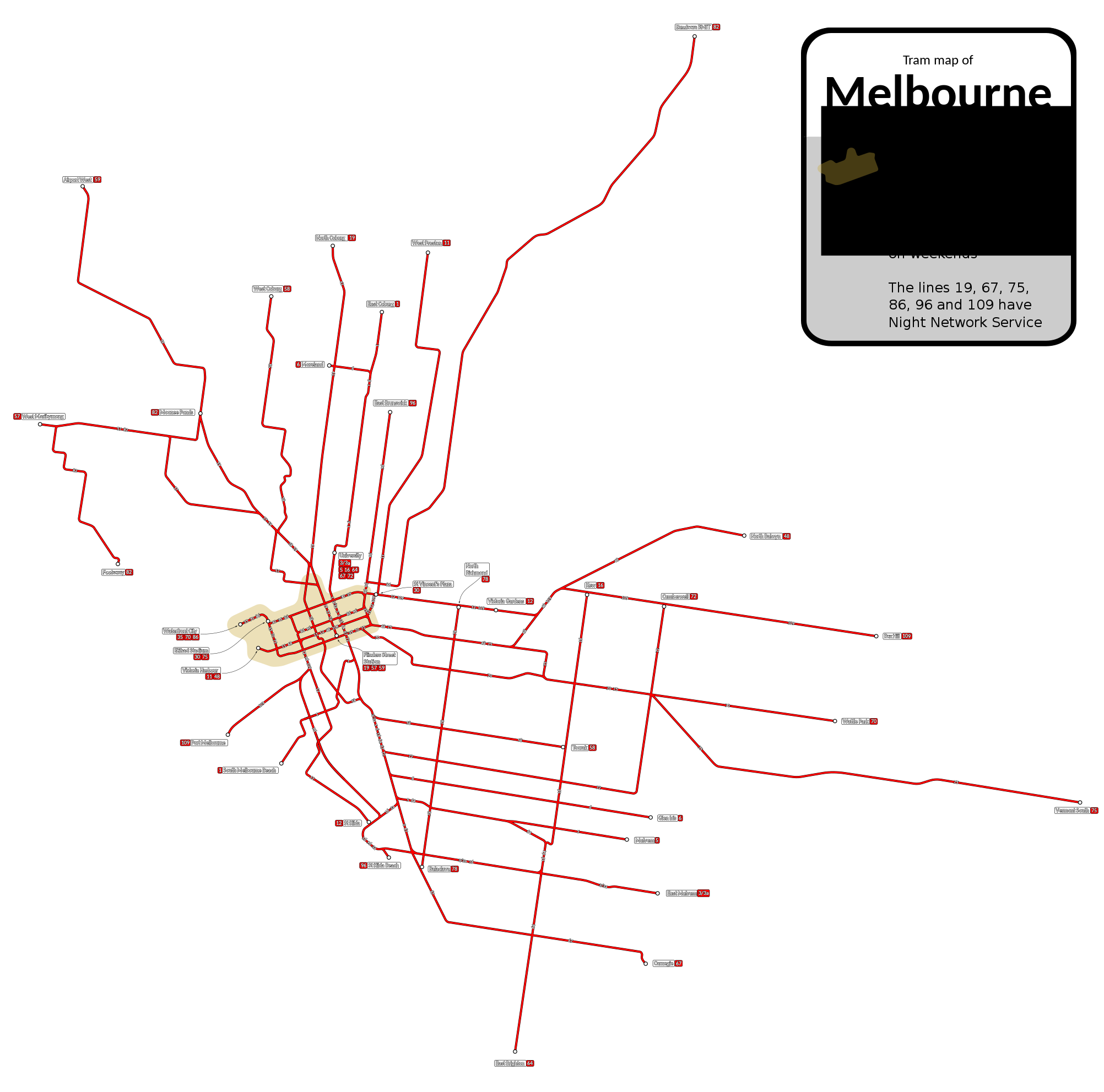
Here is Melbourne, which doesn’t yet have a metro but is building one at very high costs:
Here is Brno, which has around 200 million annual passengers in a metro area of 700,000:

The striking features of these networks and others without as good maps on Wikipedia (Gothenburg, Zurich), to me, are,
- The network design is radial – crosstown routes are rare and sporadic.
- The lines form something like a mesh in a small city center, perhaps the size of the historic premodern core, in which one can walk from one end to another; Melbourne, which does not have the history of a walled European city, shows convergent evolution with the same pattern.
- Owing to the long history of such systems, the ones I’ve used (Prague, Zurich, Basel, Leipzig, East Berlin) have basic stations with shelter and in Zurich’s case ticketing machines but no other facilities.
- There is extensive interlining and branching in all directions.
Moreover, as I should blog about soon in the future, Melbourne exhibits the same pattern even with a weak city center: the centralmost 100 km^2 of the city, which in Canada or Europe or the most centralized American cities should have 30-40% of metropolitan employment, only have 15%.

I’d suggest including Amsterdam in your list of tram cities.
The tram network there was dominant forever; it was so ubiquitous that the metro was originally called the “snelteam”, or “fast-tram”.
The city has heavily emphasized the metro in recent years. In 2019 metro ridership passed tram ridership for the first time (and then barely).
Regardless, the Amsterdam team network remains large, important, and vibrant. As well, the interplay between it and the metro more recently shows its best use (and limitations) – namely, the metro is used for longer trips and going from nearby suburbs into the city, or from one section (borough?) of the city to another. The tram is used for shorter trips in each borough, handling essentially all the city center mass transit, the last mile of many commutes, and intra-neighborhood transport in many neighborhoods.
Amsterdam’s tram network is also really quite circumferential (even pre-Noord-Zuid-lijn), even though the metro is half circumferential too.
Interesting post, would like to know more about trams/streetcars, was very much impressed by the street railways in Toronto when I visited in the early-2000s.
In general, OpenRailwayMap does have quite good information about the tram networks of the various cities.
With ridership data, even the annual reports often just state the ridership of the whole network (tram plus bus plus xxx). That’s why getting data is not that easy.
The Zürich tram network is indeed mainly radial, with a few tangential components (Hardbrücke line). There are two lines which may not or only partially be counted, because they are not VBZ, but part of the Glatttalbahn (lines 10 and 12, serving the airport). Line 12 is a tangential line, running just along the city limits, connecting several S-Bahn stations as well. The other tangential lines are (trolley)bus, where for one particular line the conversion to trolleybus is on its way. On some of these lines, high-capacity, double-articulated vehicles are used (whose capacity is comparable to the shorter trams). Also, the long-term planning (2040 and beyond) sees more tangential tram lines, which may be underground.
Why is Switzerland still a trolleybus country?
In most other places, they’ve disappeared after the cold war or seemed on their way out before the whole climate discussion…
@Herbert In Lausanne, one of the reasons was performance. Trolleybuses are good at accelerating out of stops on steep grades, which reduces the stopping penalty.
Pros and cons discussed here: https://en.wikipedia.org/wiki/Trolleybus#Advantages (I would add higher passenger comfort than combustion engines.) “Better hill climbing” than combustion buses and trams seems particularly relevant to Switzerland, as Paul also indicates.
The Swiss are not alone. As of 2012, “around 300 trolleybus systems are in operation, in cities and towns in 43 countries.”
Main reason is performance.
The ability to deal with steeper grades has been mentioned (very good example is Lausanne, although they say that some years ago, some people of the TL management suddenly drove around in S-Class Mercedes…, but they noticed that a much bigger number of vehicles would have been needed, requiring new garages etc.).
Another issue is that there are needs for capacity, and in a place where staff is expensive, the capacity of the vehicle has to be increased. And in this respect, trolleybuses have considerable advantages. It is, for example possible to have two driven axles (there were experiments with dual motor diesel buses, but they did not work out well). This gives better acceleration behavior (and of course better ability to climb grades). And the bi-articulated design would not be possible for Switzerland anyway (there are some diesel bi-articulateds in the Netherlands).
Another sign why capacity matters is that there are no standard size trolleybuses in operation in Switzerland. The last ones were retired about a year ago in Lausanne, and they were hauling trailers. And there are 6 cities which have bi-articulated vehicles.
Why Switzerland was a strong trolleybus country? Because Switzerland had a healthy bus industry, but also a rather strong electric equipment industry (MFO, BBC, SAAS, all eventually merged into ABB/Adtranz, and closed by Bombardier). There were quite a few suburban trolleybus lines, which did get replaced with diesel bused; the only remaining one is Vevey-Montreux-Chillon, which could expand their main line at minimal cost by using BTBs with IMC. There were also several cities which gave up (some for unexplainable political reasons, such as Basel or (on-going) Schaffhausen). For several of them, the newest developments simply came too late.
Interesting is La Chaux-de-Fonds, where the trolleybus operation stopped for almost a decade, because of big reconstruction in the town center. However, the wires were left hanging outside of that area. TransN (which now operates all bus lines in the Canton of Neuchâtel, recently ordered a considerable number of single-articulated BTBs with IMC, and the La Chaux-de-Fonds network gets back to electric.
For cities which already have a trolleybus network, BTBs with IMC are a very cost-efficient way to decarbonise. Comparing to BEB with overnight charging, the BTB with IMC can operate all day unrestricted (according to the chief of operation in St.Gallen, a BEB (particularly if articulated) can not perform a regular day’s work, which would mean that they would have needed additional vehicles.
The remaining Swiss trolleybus manufacturer is Hess.
Luzern–Kriens is another suburban trolleybus line.
In Germany, the Nahverkehrspläne (and their Anhänge) are usually providing a treasure trove of such data; if you’re willing to search dozens of PDF-pages. E. g. Leipzig 145,6 km line length and 120,4 mio. passengers in 2017-01-01, although that numbery already made it into Wikipedia.
Disappearances in Eastern Europa after the fall of the Iron Curtain might be a result of the general economic downfall at that time, the rise of the private automobile and indifferent or hostile attitude from politicians. (The last one seems to be a particular problem for Russian trolleybuses and trams.)
The Silesian network (where I had the opportunity to railfan some years ago) is so horribly run down in wide areas that you wonder how they manage without half the fleet being thrown out of the tracks when going faster than bicycle speed.
Base takt there is 20min on every route, with 15m cars or 30m trains; so the model split must be anemic, since they likely don’t have the capacity to get significantly more. Judging from the amount of buses (proper transit buses, not even marshrutki!), I assume that the buses eat the tramway’s lunch.
Two other characteristics of streetcar/tram networks and some trolley coach systems: 1) there may be a line or two that does not warrant the infrastructure on its own, but provides a deadhead route to the carbarn/depot for other lines and 2) there may be a line segment that is only served seasonally or for special events. The Portland Traction Company’s “Bridge Transfer” line was in the first category, partly retraced by the modern streetcar on Grand Avenue. In 2005 I rode a deadhead across town in Sczcecin on a line that doubled as a non-radial crosstown.
In the second category, Edmonton’s trolley coach Rte 3 had an extension to the Northlands Race Track for events that included a stub siding so that parked extras could stay connected to the overhead. This segment also was used for deadheads for the Highlands end of the trolley coach network. All of this replaced a similar streetcar layout. With the abandonment of the trolley coaches the low ridership segments, having lost their special functions, eventually lost their service.
This seems to be more common in streetcar systems than in heavy rail. In the latter it takes something like Berlin’s Olympic Stadium to warrant subway special provisions. I assume that the lower capital cost of the surface line makes the special infrastructure easier to justify and their lower capacity requires more special operations.
There has been discussion in Nuremberg for decades now as to whether the sole tram depot needs a second access route, because in case the one access is blocked, operations get difficult. For a time it was even discussed to make it a single track non-revenue line. The current plan seems to call for a double track revenue line.
Similarly the mothballed east-west link thru Pirckheimer Straße last saw revenue service in 2011 but is kept operational because it’s one of only two links between the eastern and the western half of the system…
One particular gimmick that seems to exist only in German-speaking areas (or went unnoticed if outside of the German-speaking area?) a track near the city’s theatre for the late night trains to wait for the end of the show.
Or the tramway came earlier and had to offer something, as nobody else was around.
Just because high-ridership trams have the features you describe (radial network, minimal stations, interlining) does not mean that these are good features. Like you say, these are very old networks where the city has been built around them for a century or more in many cases. So they may succeed in spite of some of their properties, not because of them.
Specifically:
1) Minimal stations do not seem to be an advantage in any way.
2) A radial tram network is worthwhile in the sense that radial lines generally have the highest traffic and should therefore be trams if there’s no metro. But the transit network as a whole must allow everywhere-to-everywhere travel, meaning these radial trams must be paired with circumferential or gridded buses. (In larger cities like Paris, heavy rail fills the radial role and trams fill the circumferential role.)
3) Interlining seems like it should be a disadvantage (as it is for metro), as each line is less frequent and headways are harder to standardize. Interlining on high-ridership trams seems so common that we should look for reasons why it is still used (besides “it’s always been done this way”). One possibility I can think of is that the networks in question are so complex (for historical reasons) that it’s hard to separate them into coherent lines.
1. Minimal stations save on station cost and allow for much more stations to be built with same amount of cost, hence will probably result in a better use of money by spending them on extending/maintaining the network itself rather than spending them on station facilities. it could be a tradeoff as no system face no financial constraints.
2. If the transit demand is less, and metro area is small, then transferring at center is not that much problematic, and could be preferred sometimes. Higher frequency without needing extra resources, and probably not much time lose due to the city being smaller, and also likely less circumferential demand as when a city is small it’s easier to keep everything near center.
3. I don’t see interlining as disadvantage. Metro and light rail service should be as frequent as that you don’t need to rush for a next train, aka even if you see the train is closing the door you should be comfortable knowing that you only need to wait 1 or 2 more minutes than you can comfortably walk into the other train coming up next. Hence no need to standardize headway. Although sometimes this could lead to traffic jam among light rail vehicles. As for each line being less frequent, those who want to could still make interchange.
1. With a reasonable station frequency, the cost of stations is minimal.
2. I think cities that small are unlikely to have trams to begin with, instead they will be bus-only.
3. I don’t understand what you are saying (among other things, 1-2 minute headways are rare for any mode)
The gap time after a train left before another train arrive is not headway, it didn’t take into account dwelling time
What else beyond shelter, information and a TVM does a stop need? Sure, big nodes do have additional amenities, but they are usually not on premises owned by the city.
Supportive tangentional bus lines do exist; they are apparently not in the scope of this article.
I can’t get what you mean in section 3. Keep in mind that 1 minute intervals are well feasible on tram lines, because trams operate “on sight”, and not signal-protected (except in tunnels, for example). So, overlaying lines on branches is not an issue, and in fact, welcome.
Shelter, information, TVM are sufficient. But in my experience often shelter is lacking or nonexistent.
Well run metros can do 1:30 intervals, yet interlining is considered bad practice with metros, even interlining just reverse branching 2 lines. Yet the tram systems pictured in this post interline as many as 7 lines (though some may be normal branches rather than reverse branches). I imagine that this is a recipe for irregular crowding, tram traffic jams, and very slow average travel times.
1:30 intervals, which means 40tph, aren’t THAT common. NY’s most frequent line only gets 30tph, and London’s most frequent gets 36. Paris only reaches 40tph on a few lines with highly modernized signaling systems. I think most subway lines max out somewhere between 24-30 tph. Meanwhile, 1 minute intervals would mean 60 tph, an increase of 50% over the most frequent metro lines. In addition, in order to achieve 40 tph, metros must not be interlined, as interlining on a metro leads to uneven headways. Streetcars still seem to be able to reach high tph with interlining.
New York City’s Flushing Line/7 runs local and express service in Queens. Supposedly more than 30 an hour.
40tph are more possible for trams that are driven on-sight (no signaling) than for subways etc. For a while Gothenburg had 40+ at Hagakyrkan during rush-hour. That said, being so close to the max does mean some delays, so while capacity is very high at 40tph, the travel time suffers. (Or at least that was the case in Gotheburg, and is still the case on some central stations where there lots of trams and also lots of busses.)
@Sean Cunneen
The point is that if you have a metro running every 2 minutes, interlining 2 lines, each line runs every 4 minutes. If you have a tram running every 1 minute, interlining 7 lines, each line runs every 7 minutes. That’s more than 4.
My data from 2019 says Amsterdam got 50 trams per hour onto its busiest stretch (admittedly only about 700m), which it achieved by having platforms that allowed two trams to stop simultaneously.
@fjod: Basel has a similar situation. However, they recently gave up on the double stops, and it seems to more or less still work.
I guess building a metro branch is very expensive, so that the cost of building it is much higher than operating costs, meaning that higher frequencies create better returns on investment. Meanwhile building a tram route is cheaper, which means that operating costs are a comparatively larger part of cost calculations, thus the profit-maximizing frequency is lower. Also, since trams generally have minimal stations, creating higher transfer penalties, and shorter trips, making transfer penalties a comparatively greater proportion of weighted travel time, reverse branching may be more desirable to provide people with one-seat rides.
Wheelchair boarding and an information sign is what a stop needs. A shelter and TVM might be considered “luxury”. The wheelchair boarding issue is very serious however and means you cannot have “minimal” stops of the sort used in the 1920s. By the time you’re rebuilding the sidewalk to get the wheelchair boarding working right, the added cost of a shelter looks small.
Wheelchair boarding is absolutely no big deal with low-floor/low-entry vehicles. All it needs is a curb, and the vehicle provides either a fold down or retractable step, or a motorised or manually operated fold out ramp. That’s all.
A shelter is very much not a luxury; it cuts perceived wait time by almost half, for approximately no cost. For wheelchair boarding, there are deployable gap fillers and, if you want to be fancy, Kassel curbs.
A grid is appropriate for a small town. As you get into a small modern city, sprawl means that to compete against affordable cars (and voters who will ensure the needed roads exist if transit is useless for them) you need to expect that the majority of your tram riders are going to transfer to a higher speed (more distant stops) transport mode – a metro or high speed rail to do the majority of their trip. As such a radial form where all lines converge on the transfers to a different mode is the way to go. People should ride on the tram, then transfer to the metro then transfer to a new tram to finish the trip (or maybe metro to high speed rail). The real goal is to feed the metro with the faster than walking speeds meaning metro stops can be farther apart and thus the metro can go faster in turn meaning your transit system can cover more of the city in a reasonable amount of time and thus better compete with cars that are directly door to door. Modern cities can be over 100km from the far edge of one distant suburb to the far edge of the another: the more of this you area you can cover in a reasonable amount of time the more useful transit it. (cars cannot cover this full distance in a reasonable amount of time)
Note that you can have many radial points. One tram that follows the metro but stops more often, one tram that moves over a block and then goes to the same next radial, around the circle until the tram goes to a different radial point… You don’t expect people to ride the tram the entire distance between radial points, but enough people will get on/off as to make the whole line have a use.
The above should be looked on as a thought experiment. If I had an unlimited budget to transform a car oriented city into a transit oriented city in 5 years that is what I would do. The reality is budgets are limited, cities have existing infrastructure that doesn’t play nice with the plan but isn’t worth tearing up, and several other major failings in the real world. As such every line will be a compromise of what is in place, and how long before the next step will be built. If you are building a metro and know that the next build near some area will be a tram then space your stations out even though the metro will be less useful until that tram is built (assuming you have political confidence the tram will happen, if not…). If you are building a tram reserve good places for the future metro stations.
Right now I think I would go for a metro first. I can’t see a tram network without faster transit to support it working well in any spread out city. The slow speed means takes too long to get anywhere in the city and so most people drive. Once you have a metro (even one line) a tram to extend the reach of the metro stations makes sense. If the city is large you should plan your metro to have regular and express service as well to get people father faster at the expense of more transfers.
What you describe sounds to me like what Paris is building across Ile de France. The metro is the inner grid, covering a tiny area with tight stops. The RER is radial, high speed, wider stops, extending deep into the suburbs. Both modes are increasingly fed by tramways or rapid bus in dedicated lanes. The Parisian tram lines are sometimes a radial extension of a metro line, sometimes a crosstown route linking up various radial rapid transit routes.
I’m not familiar with Paris, but I’m glad they are doing something like this – it validates the idea isn’t stupid for reasons I don’t know of.
Of course Paris isn’t starting from scratch and so they have to deal with what they already have and that will force changes.
Also a mega-city with a very dense core and inner suburbs, by western standards. The most unique thing about Paris (to my mind) is how compact the Metro proper is – few (any?) other cities have as dense a grid of rapid transit right in their core. So through running, regional services (the RER) have many transfer points to the ‘local’ metro network, which is a radial grid.
1) Minimal stations take up less space and are cheaper to build and maintain, so are more suitable to be built more densely. Since trams are slower than proper rapid transit, people are willing to walk/bike shorter distances to/from stations, requiring high station density.
2) Agreed. I think this makes the question of what a tramway network looks like kinda weird. If a city has trams as its highest speed/capacity tier of transit, then it should look like a rapid transit rail network. Just because average speeds tend to be worse than rapid transit rail doesn’t mean the optimal layout of your highest tier of transit changes. A bus only city is different because the highest tier and lowest tier of transit are basically the same.
3) Trams are usually operated on sight, move slowly, and stop fast, so tight headways are easier. 30-45TPH rapid transit rail is rare, and requires uncommon technology, especially with complicated service patterns (non-existent with complicated service patterns?). 30-45TPH tram trunks are comparatively common, and don’t need fancy modern signalling. This means interlining might still have bad effects on frequency due to demand, but not due to capacity constraints.
1) I think every station should have a shelter that actually shelters from the weather. Many don’t.
2) Exactly
Only a roofed station can actually shelters from the weather and admit it, many heavy rail stations aren’t roofed.
Given that trams do not operate on fixed block signals, there is less of a need to keep interactions caused by interlining on a precise schedule. In most cases, the schedule accommodates minor delays like “braking for the dog on the tracks” and can do the same if one interlining train has to wait for the other.
Of note, Nuremberg’s trams used to have a lot of interlining, got rid of it (almost) entirely during the shutdown phase and is now planning to reintroduce it. So there must be some benefit, otherwise the removal of interlining would’ve been permanent. Maybe those advantages do not outweigh the downsides, but they certainly exist…
Lack of fixed block signals doesn’t mean there are no capacity constraints: if you have a big intersection with a lot of automobile traffic, you might run into a limit of how many trams can be squeezed across in one signal cycle.
And the advantages of interlining are obvious: if you are already doing it this way, you have to change something to get rid of it; but not to keep it. And if you deïnterline, somebody (probably some poor granny) will complain about losing their beloved direct tram to somewhere.
For the disadvantages of interlining with reverse branching, you have to use the network to see them. Like changing to an infrequent route within 4min, where you walk 2min and have 2min to spare, unless the tram stops because of the dog on the tracks and misses its green at the next light and arrives 2min too late at the interchange and you miss your half-hourly train or bus or whatever and think things you couldn’t say out loud, even if no children are present.
Then you decide to take a tram 10min earlier and end up with 14min to change to the infrequent route, and you use that time to notice that this trip, which takes 30min by car and 40min by transit, has just increased to 50min. With one 5min interval instead of two 10min reverse branched intervals, you can fine-tune your transfer time into shorter intervals. And you get a 5min interval on the way back, instead of a 10min interval and another one that joins further down the line.
As an example, try to catch an S-Bahn from the City-Tunnel Leipzig when starting along routes 2 or 8: https://www.l.de/verkehrsbetriebe/netzplan/ (I’m sure Alon has a post about this topic, somewhere in the attic.)
Easier if you want to change between two such double-routes, then you just remember “A to X-road and then C to V-town, or B to Y-road and then D to Z-town (which is two stops before V-town)”. Or maybe A to Y-road and then D is also possible, but takes longer because A takes longer and you miss one train.
If the interlinded routes stay together until the transfer point, then this doesn’t apply.
Melbourne is not building a metro. They are calling it “Metro Tunnel 1” but it’s really an S-Bahn style tunnel for through-lining suburban trains. The suburban network is confusingly called “Melbourne Metro” but it does not have metro characteristics: it has low frequencies, mixed stopping patterns, track sharing with regional and freight trains, and a large number of level-crossings, even some single-tracked segments.
Something you don’t mention is that traditional radial tram networks have a sweet spot of utility, since they can provide a high mode share up to around 8-10km out from the city centre (depending on line speeds, stop spacing and the amount of mixed traffic running). Beyond that commutes are too slow to be useful and you need rapid transit. So it works well for compact mid-sized European cities that tend not to exceed that radius anyway. In Melbourne’s case, the network was good for the city’s size in the 1950s, but inadequate now. It needs to be integrated with rapid transit, but unfortunately many of the lines are built to compete with the railway lines rather than complement them (see the no. 19 on Sydney Rd, for instance).
That competition against railway lines is not necessarily bad; the tram line can act as a mid-level distributor between the stations, allowing the heavy rail to have fewer stations, and operate faster and more efficient.
Also note that with the radial lines, most of them are through-running; lines ending at the center only occur if there is a certain imbalance between the parts of the city. But that may change when new branches become operational.
That’s not how it works in Melbourne though, the lines were literally built to compete with each other (they were operated by different companies), and still function like that, even with integrated ticketing now. The result is the train (which makes frequent stops, every 600-800m) is lightly used and the overloaded trams get stuck in traffic (also an unfortunate feature of most of Melbourne’s tram network).
Apparently the Melbourne “metro” has 243 million riders per year which seems to be more than the tram. They are working on eliminating a lot of the level crossings. I imagine that low frequencies on branches are a result of congestion and interlining in the core? If so, “Metro Tunnel 1” should help with it.
It has more patronage because it covers the whole metropolitan area, whereas the tram network mostly only covers the mid-century inner core. Once you get to within about 5km of the CBD tram patronage mode share is much higher than rail, which significantly under-performs.
The situation will get a little better with level crossing removals (but only a small fraction are planned to be eliminated) and the new tunnel, but the city loop needs open-heart surgery to be fit for purpose and integrated planning has historically been lacking (most stations are poorly located with respect to town centres).
Incidentally, Melbourne is also building a “Suburban Rail Loop” which will be a kind of orbital metro, not too different to the IBX, but a lot more expensive because there is no pre-existing ROW. It will help to de-radialise the city.
I mean the Shinkansen doesn’t have mixed stopping patterns and is super successful. I wonder even with long distance rail they are bad.
There’s no reason that at your interchange points that you can’t have lots of staff to help passengers change trains.
https://en.wikipedia.org/wiki/Nozomi_(train)
https://en.wikipedia.org/wiki/Hikari_(train)
https://en.wikipedia.org/wiki/Kodama_(train)
True. But on the main bit of the line (Tokyo to osaka) they do have one stopping pattern – especially the nozomi trains.
The three service types define the stopping pattern with timed overtakes by the superior service.
Then why is the greater Nuremberg area building a 25 km line via Erlangen to Herzogenaurach?
Are they expecting all that many people to actually ride that line end-to-end? Or is it rather that there are a number of not-quite-as-long traffic relations that overlap in such a way that it is still operationally more advantageous to have *the vehicles* running through? (There’s also the impetus that connecting to the existing Nuremberg network means not having to provide a dedicated *maintenance* depot – stabling sidings might be required, though – and a separate set of spare vehicles.)
Bratislava is around 70 mil passengers/year pre-covid, with a big increase coming in 2024. The first line to the biggest district Petrzalka (150k pop) will be operational.
I know Petržalka is mostly panel type housing, but is it a mid, lower or high class area?
In this context, Hong Kong’s NWNT area Light Rail system seems a little bit different… (The area have a metro line now, but that’s mostly for traveling to other parts of Hong Kong, and in most case the light rail is still preferred when traveling within coverage of the network. Operator have tried to shift light rail inter-town passengers to heavy rail, even with free transfer making trip connecting via heavy rail will be cheaper than just traveling on light rail, but that wasn’t really successful.)
https://i.imgur.com/ZLgFZaz.png This is a map taken from urbanrail dot net, with purplish blue circles added by me to indicate central parts of towns in the network. Each of them are named Yuen Long, Tuen Mun, and Tin Shui Wai, as indicated by the name of heavy rail station in each respective circle.
The system do appears like radial at all three centers, but within their geographical limits both the tracks in Tin Shui Wai and Tuen Mun area formed multiple loops.
Due to the high density nature of new development in Tin Shui Wai and Tuen Mun, and the nature of old development along the main street in Yuen Long, they cannot be said as forming a mesh. But all the key commercial facilities and destinations are within short walk from each of the light rail stations
The light rail system was developed around 1980s, together with the town themselves. Although the main street of Yuen Long have older history.
https://www.td.gov.hk/mini_site/atd/2019/en/section5_2.html
As of year 2018, the system have 492k/day ridership, or 180 million/year. In the 10 years ending in year 2018, the ridership continually increased, and the increase have added up to ~25% over the past ten years. There were no new lines in the period of line but population and development in the area have been keep growing.
As of year 2016, the two districts encompassing the region have 1.1 million population. The figure also include people outside the system’s coverage.
However, different parties the Hong Kong government and the operator MTR seems to have been trying to sabotage the system, including proposals like single-tracking or eliminating the Yuen Long section of the system to free up more road space, or to reroute it through outer part of the area, and then as the government trying to develop two new zones neighboring this light rail system, they claim the current high floor light rail cannot provide sufficient capacity, and thus they recommend a low floor tram (or AGT or BRT) for transit in new development zones, which is expected to intersect the Light Rail system at Nai Wai station, forming a “X” shape cross between the two incompatible system
HK LRT is different because it is separated from road traffic for most of its length. LRT is, as its name suggests, a rail system instead of a tram system.
But there is one thing about HK that makes its experience inapplicable to most of the world — density. HK is super dense and any workable transport system will have huge ridership. Hong Kong Tramways had 4 million passengers per year per kilometer (higher than most systems mentioned here) even though it has no air-conditioning and is in direct competition with the metro.
Ideally at-grade tramways with 800-1000 meter stop spacing along the few arterials in urban agglomerations with some sort of density would be the most cost effective solution for most US cities. Minneapolis Green and Houston Red line are an example of what should be the norm. Even Phoenix following this principal has better ridership per mile than absolute disasters like Dallas and Denver despite having the most unfavorable environment for transit ridership
Phoenix with 1,800 btw has a similar ridership per mile per day as Manchester with 1,900. Generally the UK light rail boom has produced some absurdly low ridership systems (for European cities). French system seem to do better Grenoble has almost 9,000, Saint-Étienne 12,000, Besançon 2,600, Dijon 7,200, Brest 3,700, Orléans 4,300, Tours 7,100, Mulhouse 7,200, Reims 6,600, Strasburg 5,000 (there’s a huge discrepancy in daily and annual ridership which is weird), Valenciennes 800, Caen 3,800, Le Havre 6,200, Rouen 5,900, Bordeaux 5,900, Montpellier 4,800, Toulouse 3,300, Angers 3,700, Le Mans 4,400, Nantes 7,800, Aubagne 3,600, Nice 11,300
The UK systems are all pretty underwhelming – Nottingham 2,600, Croyden 4,400, Birmingham 1,600, Sheffield 1,900 (from its best year), Edinburgh 2,400, Manchester 1,900
The UK examples are mostly doing different things to the French ones – Birmingham and Manchester with their underwhelming figures are really light rail systems more along the lines of what you’d find in the US (and they have longer distances and mostly off-street alignments to boot). Nottingham has the best ridership per km/mile and its system is most like the French cities you cite in terms of its layout.
Part of it is the UK’s bad ticketing systems, which discourage through ticketing between bus, rail and tram. Part of it (I think perhaps more than people here might first assume) is about an urban form which outside of central cities is rather low-density – I may make a comment in more detail about that.
Are you sure you’re not comparing miles to kilometres though? I doubt you’d be finding French figures in riders/mile. That may explain at least some of the discrepancy in the figures.
No everything is per mile f.e. Nice – 193 000 voyageurs par jour – 27.5 km | 17.1 miles – 11,300 pax per mile.
About urban form – Dublin a city with an UKish urban form significantly performs better than Manchester or Birmingham with 4,400 pax per mile-
if the figures were ridership per km it would be even worse as 11,300 per km would be 18,200 pax per mile
Birmingham and Edinburgh are US style failures. Manchester is a perfectly serviceable tram-train system that’s in a city that’s too big for it. Nottingham is one pretty good line, half an okay line and nothing to connect to because the East Midlands have “strong communities” or something so they don’t need EMU’s*.
Croydon tram on the other hand is fine, its pretty similar to Parisian orbital trams. Its ridership problem is NIMBYS.
*The East Midlands is the most Conservative region outside Southern England, and next election will probably be the most Conservative. Its the Ohio of England.
Agreed on all points – but a tram-train system is always going to have lower passengers/mile because it’s a different thing to the sort of tramways you tend to find in France (same way that even a very successful HSR system will have far lower passengers/mile).
Was kinda about ridership per mile across Europe’s tram systems so here I gonna start with the Nordics
Göteborg – 141 million per year | 49.7 miles | 7,800 per mile (per day)
Lund – 43,895 last August | 3.4 miles | 416
Norrköping – 5.47 million | 11.6 miles | 1,300
Stockholm Sparväg City – 20,000 per day | 2.2 miles | 9,100
Stockholm Tvärbanan – 108,000 per day | 12.4 miles | 8,700
Stockholm Lidingöbanan – 14,300 per day | 5.7 miles | 2,500
Stockholm Nockebybanan – 11,800 per day | 3.5 miles | 3,400
Bergen 51,110 per day | 12,7 miles | 4,000
Oslo 53 million per year | 24.6 miles | 5,900
Trondheim 2,000 per day | 5.5 miles | 400
Helsinki 60.2 million per year | 23,6 miles | 7,000
Tampere 30,000 (weekday opening month) | 9.9 miles | 3,000 (forecast for 2023 5,100)
Aarhus 6,300 per day (Phase 1A) | 7.4 miles (1A) | 850
Low Countries
Kusstram – 16.5 million | 41.6 miles | 1,100
Ghent – found no data | 19.9 miles
Luxemburg 67.000 (October 2021) | 4.7 miles | 14,300
Amsterdam – 113.5 million | 59 miles | 5,300
The Hague – 87.2 million | 65.2 miles | 3,700
Rotterdam – 44 million | 46.6 miles | 2,600
Utrecht Uithoflijn 30,000 (February 2020) | 5.0 miles | 6,000
Utrechtse sneltram – 5.6 million | 12.9 miles | 1,200
Alps
Basel – 87.95 million | 49.1 miles | 4,900
Bern – 49,1 million | 24.6 miles | 5,500
Genève – 94.42 million | 22.4 miles | 11,500
Zürich – 202.6 million | 52.2 miles | 10,600
Gmunden – 1,660 (2018) / 2,260 (2019) | 1.4 miles (2018) / 11.1 miles (2019) | 1,200 / 200
Graz – 52 million | 43.8 miles | 3,300
Innsbruck – 11.5 million | 16.5 miles | 1,900
Linz – 65.4 million | 18.9 miles | 9,500
Vienna – 305.8 million | 109.9 miles | 7,600
Very interesting data!
Just to fix Helsinki it is actually about 48 km eg. 30 miles. For some reason the network owner / operator quotes 38 km, which is plainly incorrect. We asked the actual infrastructure manager to check and he came up with 99 km of single track on the active lines. Hopefully they can fix the website as well soon. Useful length depends on how you count loops etc. Robert Schwandl’s (urbanrail.net) interpretation is 48 km, so I’d go with that.
So Helsinki would be around 5500 as you seem to be using 365 days per year. I usually use 300 days to approximate weekdays (working days) from annual figures.
Add Yekaterinburg to the list. It has a short (9 station) metro but largely relies on trams with tram ridership around 200 million p.a. depending on the year.
Random question: I noticed the Frankfurt U-Bahn route A is a stadtbahn line with a 4km unbranched aboveground segment. Wouldn’t this segment reduce the lines capacity to that of a tram line? If it does, was it worthwhile to build a dedicated tunnel for this line in the first place?
The A-Line actually has the highest throughput with one train every 2.5 minutes per direction as well as highest ridership. Putting it underground would shelf some minutes but is not worth the investment/ busstitution of 140k riders per day. It’s popular demand locally but will never pass any cost/benefit analysis so no federal funding covering up to 80% of project cost. There’s some inbuilt provision to continue the tunnel further north but since the 1960s the funding situation significantly changed making “quality of life” projects without significant travel time savings, modal shift or ridership increases unfundable.
The above ground section of the A-Line (this designation is not used any more) is pretty much designed to heavy rail standards. There is strict segregation from traffic, the stations have high-level platforms, pedestrian crossings are via underground passageways and as far as I know there is absolute signalling priority. So they can still run very high frequencies with relatively long trains (up to four carriages).
Nowadays (also due to accessibility) considerations there are level pedestrian crossings at every station and some even in between. Except for two station pedestrian tunnels have been disused
From post:
“The network design is radial – crosstown routes are rare and sporadic”
Unless I have my terminology mixed up, this is definitely not true for Gothenburg. All lines go from one end of the city to another. And all lines pass the core. Until not-so-long-ago each and every line passed the next-to-each-other Centralstation & Brunnsparken. These days it is possible avid that using Ullevi Södra – Ullevi Norra, but only line 8 does that.
There are plans, in a loose sense, to enable bypass of those two stations both the north and south, but both would still pass through the core of the city.
Had intended to inlcude url to a map of gothenburg tram-system for reference:
https://sv.wikipedia.org/wiki/G%C3%B6teborgs_sp%C3%A5rv%C3%A4gs_linjen%C3%A4t#/media/Fil:G%C3%B6teborgs_sp%C3%A5rv%C3%A4gsn%C3%A4t.svg
It seems Alon was referring to the Manhattan definition of “crosstown”, i.e., from one river to the other, perpendicular to the downtown lines. In other cities that might be called circumferential. So you’re both in agreement.
So Paris should have the highest-ridership “network” by 2025. 2019 it had 340million passenger, with the T9 opening last year, T10, T12 and T13 opening the coming years and extensions of T1, T3b, T8, it will surpass 400milliion.
Starting 2025 the Grand Paris Express will open section by section and will reduce load on the current overloaded lines T1, T2, T3a, T3b. So by 2030 if the network doesn’t expand further, it might fall again. For now only further T1 and T11 extension are planned.
San Francisco’s cable car and antique trolley car systems count as “trams”? Also, Barcelona has very nice tram system.
SF isn’t an example of a good tram network though. SF has a few tourist trolleys and a single trunk stadtbahn.
It’s worse than that. SF’s Municipal Railway (SFMuni) is a chimera (polite) or a mutant, bastard hybrid. Yes, it has strong tram roots but the various grafts have mutated over the years. First, one has to break up the rail transit into four (4) parts : Heritage-CC, Heritage-PCC, Metro-Main (JKLMN routes), and Metro-Vanity (T-Third). The cable cars, Heritage-CC, are really two systems – California vs. Powell – that share a car barn and a power plant. The rolling museums, Heritage-PCC (PCC’s + other streetcars), are part tourist bait and part gap filler. Metro-Main is the second generation streetcar network with the downtown core in a tunnel. Metro-Vanity is a rather toxic gift from Willie Brown that will soon (?) have its own tunnel (Central Subway).
For comparison purposes one should limit oneself to Metro-Main. The other parts will distort your numbers in a hurry. Also, keep in mind that BART serves as line Z(oom) for rides between Balboa Park / Glen Park and the downtown (Civic Center). Geneva+Mission via Mission is around forty-five (45) minutes. Via Balboa Park it’s around fifteen to twenty (15-20) minutes.
P.S. I grew up in S.F., enjoy watching SFMuni’s antics, and pay for my rides with a Clipper card.
I don’t think the sparsity of crosstown routes is really a common feature, unless Alon refers to orbital/circumferential lines.
The paucity of lines terminating in the city centre is mostly explained by the lack of space. Older, short tram models, with doors exclusively on one or the other side of the vehicle, usually reversed using a turning loop, which is cheap and easy to build out in the suburbs but difficult to arrange in a city centre.
The lack of station amenities is similarly explained by the fact that most tram lines started out in the same modal niche as buses, but have gradually been promoted into a class above that with the adoption of larger, articulated rolling stock.
Branching is also somewhat easier with trams than trains, because dispatch doesn’t need to be as strict about maintaining train order.
I am referring to orbital lines when I’m saying crosstown, yeah. Sorry if it was unclear, you’re right that there are two meanings to the word crosstown or cross-city.
Cross Suburb? That might be confusing because the definition of “suburb” is very flexible. Non-central business district? Non-core? The central business district will look radial because that’s the nature of CBDs.
Looks very crosstown-y if the top of the map is West.

It doesn’t show individual lines very well. The Flushing/Second Ave trains skirt Midtown. Very radial form the point of view from South Ferry at the tip of Manhattan. Someday the Queens Blvd/Second Ave. trains will be skirting Midtown too. Most places don’t have a second central business district with enough demand.
.
Here’s a nice map of the Zurich tram network: https://upload.wikimedia.org/wikipedia/commons/a/ae/Tramnetz_Z%C3%BCrich_2022.png
From this Wikipedia article: https://de.wikipedia.org/wiki/Strassenbahn_Z%C3%BCrich
This is very nice, the public transportation system itself has only stylized maps, but those also show how the bus system provides the cross-connections between the radial tram lines: https://www.stadt-zuerich.ch/content/dam/stzh/vbz/Deutsch/Ueber%20das%20Departement/Publikationen%20und%20Broschueren/Fahrplan/liniennetzplaene/Stadt%20ZH.pdf
It is indeed a nice map.
I think you -and the referenced system maps- may have missed the extensive tram system of Vienna.
(It would also be helpful to have a scale bar at each map.)
That’s because Vienna has an U-Bahn system. The question was: if the trams are the *primary* urban rail service, what does the network look like?
As already mentioned, in a tramway city, tangential routes are mostly delegated to the rubber-tired folks.
In ye goode olden days, most tickets (if the conductor issued something at all instead of simply memorizing) were only valid for one trip without transfer; that doesn’t encourage a network based on transfers. Additionally, there was no competition from the private automobile, this didn’t arrive at European common people until after WW2. But there was often competition between different tramway companies.
(In the present, I personally abhor reverse branching when having to combine it with a transfer to or from another route—from bad real-life experience!)
What’s the history of competition in Eastern Europe, though?
You can see the “downtown mesh” (as well as interlining) in the past of Nuremberg’s tram system (then also extending to neighboring Fürth) https://commons.m.wikimedia.org/wiki/File:Strassenbahn_Nuernberg_Streckennetz_1939.svg and in plans for the future https://commons.m.wikimedia.org/wiki/File:Stra%C3%9Fenbahnnetz_N%C3%BCrnberg_Szenario_2030.png but no so much in the current state of affairs, which has of course suffered a load of metro related and war related and “just ‘coz” shutdowns… https://commons.m.wikimedia.org/wiki/File:Stra%C3%9Fenbahnnetz_N%C3%BCrnberg.png
> The network design is radial – crosstown routes are rare and sporadic.
> The lines form something like a mesh in a small city center, perhaps the size of the historic premodern core, in which one can walk from one end to another; Melbourne, which does not have the history of a walled European city, shows convergent evolution with the same pattern.
> Owing to the long history of such systems, the ones I’ve used (Prague, Zurich, Basel, Leipzig, East Berlin) have basic stations with shelter and in Zurich’s case ticketing machines but no other facilities.
This sounds a lot like a bus network in a similarly-sized city. The small city centre contains everything special in the city: the business district, the central market, the shopping street, the theatre, the concert hall, maybe even the hospital. Outlying districts are mostly similar, and cross-district travel is rare.
> There is extensive interlining and branching in all directions.
That’s because it’s relatively cheap to create two bus routes to North Foo and South Foo that run along parallel streets (you just need 2x bus shelters), but much more expensive to do this with tram lines.
What I would really like to see compared is the degree of grade separation successful tram networks have. I remember Zagreb’s being almost completely separated from car traffic outside the city centre.