Consolidating Stops with Irregular Spacing
There was an interesting discussion on Twitter a few hours ago about stop consolidation on the subway in New York. Hayden Clarkin, the founder of TransitCon, brings up the example of 21st Street on the G in Long Island City. The stop is lightly-used and very close to Court Square, which ordinarily makes it a good candidate for removal, a practice that has been done a handful of times in the city’s past. However, the spacing is irregular and in context this makes the stop’s removal a lower-value proposition; in all likelihood there should not be any change and trains should keep calling at the station as they do today.
What is 21st Street?
The G train, connecting Downtown Brooklyn with Long Island City directly, makes two stops in Queens today: Court Square, at the southern end of the Long Island City business district, and 21st Street, which lies farther south. Here is a map of the area:
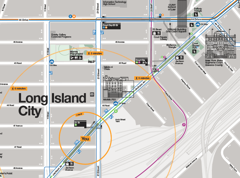
At closest approach, the platforms of 21st are 300 meters away from those of Court Square on the G; taking train length into account, this is around 400 meters (the G runs short trains occupying only half the platform). Moreover, Court Square is a more in-demand area than 21st Street: Long Island City by now near-ties Downtown Brooklyn as the largest job center in the region outside Manhattan, and employment clusters around Queens Plaza, which used to be one stop farther north on the G before the G was curtailed to Court Square in order to make more room for Manhattan-bound trains at Queens Plaza. Court Square is still close to jobs, but 21st Street is 400 meters farther away from them, with little on its side of the neighborhood.
Stop spacing optimization
Subways cannot continuously optimize their stop spacing the way buses can. Building a new bus stop costs a few thousand dollars, or a few ten thousand if you’re profligate. Building a new subway stop costs tens of millions, or a few hundred million if you’re profligate. This means that the question of subway stop optimization can only truly be dealt with during the original construction of a line. Subsequently, it may be prudent to build a new stop but only at great expense and usually only in special circumstances (for example, in the 1950s New York built an infill express station on the 4 and 5 trains at 59th, previously a local-only station, to transfer with the N, R, and W). But deleting a stop is free; New York has done it a few times, such as at 18th Street on the 6 trains or 91st on the 1. Is it advisable in the case of 21st?
The answer has to start with the formula for stop spacing. Here is my earliest post about it, in the context of bus stops. The formula is,

The factor of 4 in the formula depends on circumstances. If travel is purely isotropic along the line, then the optimum is at its minimum and the factor is 2. The less isotropic travel is, the higher the factor; the number 4 is when origins are purely isotropic, which reflects residential density in this part of New York, but destinations are purely anisotropic and can all be guaranteed to be at distinguished nodes, like business centers and transfer points. Because 21st Street is a residential area and Court Square is a commercial area and a transfer point, the factor of 4 is justified here.
Walk speed is around 1.33 m/s, the walk penalty is typically 2, the stop penalty on the subway is around 45 seconds, and the average unlinked trip on the subway is 6.21 km; the formula spits out an optimum of 863 m, which means that a stop that’s 400 meters from nearby stops should definitely be removed.
But there’s a snag.
The effect of irregular stop spacing
When the optimal interstation is 863 meters, the rationale for removing a stop that’s located 400 meters from adjacent stations is that the negative impact of removal is limited. Passengers at the stop to be removed have to walk 400 meters extra, and passengers halfway between the stop and either of the adjacent stops have no more walking to do because they can just walk to the other stop; the average extra walk is then 200 meters. The formula is based on minimizing overall travel time (with a walk penalty) assuming that removing a stop located x meters from adjacent stops incurs an extra walk of x/2 meters on average near the station. Moreover, only half of the population lives near deleted stops, so the average of x/2 meters is only across half the line.
However, this works only when stop spacing is regular. If the stop to be removed is 400 meters from an adjacent stop, but much farther from the adjacent stop on the other side, then the formula stops applying. In the case of 21st Street, the next stop to the south, Greenpoint Avenue, is 1.8 km away in Brooklyn, across an unwalkable bridge. Removing this stop does not increase the average walk by 200 meters but by almost 400, because anywhere from 21st south in Long Island City the extra walk is 400. Moreover, because this is the entire southern rim of Long Island City, this is more than just half the line in this area.
In the irregular case, we need to halve the factor in the formula, in this case from 4 to 2 (or from 2 to 1 if travel is isotropic). Then the optimum falls to 610; this already takes into account that 21st Street is a weaker-demand area than Court Square, or else the factor in the formula would drop by another factor of 2. At 610 meters, the impact of removing a stop 400 meters from an adjacent stop is not clearly positive. In the long run, it is likely counterproductive, since Long Island City is a growth area and demand is likely to grow in the future.
Does this generalize?
Yes!
In New York, this situation occurs at borough boundaries, and also at the state boundary if more service runs between the city and New Jersey. For example, in retrospect, it would have been better for the east-west subway lines in Manhattan to make a stop at 1st or 2nd Avenue, only 300-500 meters from the typical easternmost stop of Lexington. The L train does this, and if anything does not go far enough – there’s demand for opening a new entrance to the 1st Avenue stop (which is one of the busiest on the line) at Avenue A, and some demand for a likely-infeasible infill stop at Avenue C. These are all high-density areas, but they’re residential – most people from Queens are not going to 2nd Avenue but to Lex and points west, and yet, 2nd would shorten the walk for a large group of residential riders by around 400 meters, justifying its retrospective inclusion.

A couple of nits:
• The Pulaski Bridge is technically walkable (the walking and cycling paths are even physically separated), but the pedestrian environment on both ends is awful. Call it a walk penalty multiplier.
• Surprisingly enough, during the 14th Street Tunnel project the MTA did manage to add those Avenue A exits. Believe it!
If New York implements your subway deinterlining plan and removes the R from the QBL, they can return the G to Queens Plaza.
They could turn the G at Queens Plaza, if that were a necessity.
The G is infrequent. Operate the G to Queens Plaza on the Jamaica bound track (D2). Reverse direction, wrong rail back on D2 to Court Sq and then switch to the Bklyn bound track (E1) between Court Square and 21st St. The track between Court Sq to Queens Plaza would be an absolute block. The D2 track at Queens Plaza would be shared only with the R. There’s enough time between R trains to reverse direction.
There are 8 tracks of railroad west of Queens Plaza and 6 east of Queens Plaza. Something somewhere has to give an it’s the Crosstown train.
The relevant measure is how long individual tracks are occupied, not their number.
Pour 8 tracks of railroad into 6 six tracks of railroad something somewhere isn’t going to work out.
@Alex_Cat3 Not neccessarily. Deinterlining is designed to maximize the capacity of a line, in this case Queen’s Blvd to Manhattan, by minimizing the amount of switching. By reintroducing the G, you negate the entire idea behing deinterlining.
However, there may be a way to still extend the G to Queen’s Plaza. The Local to Express crossovers are placed after the platforms, in both directions, at that station. Therefore, trains wait at the platform before navigating the interlocking, approching it from a stand. If the 53rd St. tunnel trains all take the Queen’s Blvd local and the G accesses the pocket track, then every train approching these crossovers take the diverging path. An enforced stop, no switching, and no need to clear more than the block containing the diamond are all conditions that minimize the delay caused by a level crossing. The G, being of lower frequency and being in non-revenue service or at start of service, can also always wait for the higher priority Queen’s Blvd train to clear first.
This is the way I would set up the service (see my old blog linked to my handle) but it’s not compatible with Alon’s preference to send express trains through 53rd St, which has other merits.
Actually, if you ran express trains through 53rd street, the G and the E would be completely separate, as the E enters the station on the express tracks, while the G enters on the local tracks. The problems with making 53rd the express and 63rd the local are: unless you install express platforms at 36th street, which could be expensive, it would cut off the local Queens Blvd stations from Queensboro Plaza, and you would need to either add expensive bumper tracks to the E train’s WTC terminal to be able to run it frequently enough or make the E the 8th Ave express and have it continue out into Brooklyn. An alternative is running the F as express and the E as local, as I prefer (Alon left it undecided in their plan) and spending maybe $100-$200 million to install a new crossover to eliminate the conflict between the E and G. The Queens bound crossover is already in the right place, so you would just need to replace the Manhattan bound one, and there is an unused crossover going the opposite way (express to local rather than local to express) that would be a good location for it. The track map on which I based this post is linked below.

Yeah, I suspect deinterlining would make a 36th Street express conversion valuable, I just don’t know the cost. (New York mulled an express conversion for 59th on the 2/3 as well but never did that, unlike on the 4/5; I do not know why.)
In my personal opinion, deinterlining is fine without making 36th express if the E runs local, but if the F is the local train, converting 36th to an express would be almost a requirement. If the F is the express, the local stations only loose access to 21 St Queensbridge and Roosevelt Island, neither of which are very important, and Lexington Ave/63rd st. Otherwise you cut off the local stops from Long Island City unless they backtrack which would be a 15 minute trip from 36th to Queens Plaza assuming current speeds and an instantaneous transfer. They also get cut off from the transfer to the 6 train at 53rd street, making it awkward for them to get to jobs on the East Side– the best option for that I can see would be a 220 meter out of system transfer between Lexington/63rd and Lexington/59th.
Ooh, this is making me think that the current pattern is valuable as a decongestion policy – the better train to Manhattan, i.e. the express, runs separately from the train to LIC.
[Ooh, this is making me think that the current pattern is valuable as a decongestion policy – the better train to Manhattan, i.e. the express, runs separately from the train to LIC.]
Um, yeah. The downside is that trips to the most popular destinations are slowed, but that downside is irrelevant when pass-ups start occurring.
Run all of the Queens Blvd express trains through the 63rd St. tunnel there aren’t enough trains going through the 53rd street tunnel.
Run all the locals through 53rd, move the R to the Astoria Line.
Stuff all of the Queens Blvd expresses through 63rd they saturate the Sixth Ave Local tracks. All of the trains through 53rd are then on 8th Ave. There isn’t enough of them or there is no C train north of 50th Street. The Crosstown train is still terminating at Court Square.
Push one thing one place something else bulges far away.
Okay, so run all Sixth Avenue locals via 63rd and not 53rd, and then either kill the C and shore up the B or kill the A and shore up the D (the 53rd tracks can connect to either Eighth Local or Eighth Express).
The way to operate all tracks at a nominal 30 tph with balanced merges is as follows for uptown direction.
6th Ave Local – F & M each at 15 tph, merge before Bway-Lafayette and diverge after 50th St.
8th Ave Local – E & C operate each at 15 tph, merge at Canal and diverge after 42nd St
Bway Exp – Q & N each operate at 15 tph, merge after DeKalb and diverge before 63rd & Lex (Q to SAS)
Bway Local – R & W each operate at 15 tph, merge after Whitehall & City Hall and both operate to Astoria
63rd St Tunnel – F & N each operate at 15 tph, merge before 63rd & Lex, diverge at 36th St
60th St Tunnel – Q & N each operate at 15 tph, both operate to Astoria
53rd St Tunnel – E & M each operate at 15 tph, merge before 53rd & 5th Ave and diverge after Queens Plaza
Queens Blv Exp – E & F each operate at 15 tph, merge at 36th St
Queens Blv Local – M & N each operate at 15 tph, merge at 36th St
11th St Cut eliminated from regular passenger service
Additional terminal facilities required on Astoria Line – possible add switch before Astoria Blv to use center track
Forest Hills has adequate terminal facilities for relay if fumigation policy is changed or sufficient number of platform conductors are provided.
How does the Q to operate to Second Ave and Astoria or the N train to Forest Hills and Astoria?
My mistake.
60th St Tunnel should read: R & W each operate at 15 tph and operate to Astoriia
R & W are both on Bway Local Track. They opertate via 60th St Tunnel to Astoria.
Q & N are both on Bway Exp Track. Q opererates to SAS. N merges with F before 63rd & Lex and uses 63rd St Tunnel
At 36th St: F merges with E onto Queens Blv Exp track, N merges with M onto Queens Blv Loc track.
Killing off the A train isn’t a viable option.
Your analysis is ignoring the proximity of the #7 Hunters Point and Vernon-Jackson stations.
I agree, I do the out of system transfer most days from 21st to Hunters Point on the way to work. I also see people going from the Hunterspoint LIRR station to the G.
A completely imaginary reworking of the LIC subway map would probably include removing the 21st station but adding a G stop at Vernon with transfer to the 7. Vernon is a much better location for a G stop in-between Court Sq and Greenpoint Ave and having a transfer to the 7 there would make getting into Manhattan much easier for people instead of having to go all the way to Court Sq and navigating that awful station to get to the 7.
They don’t even need to remove the stop. The 21st Street station’s platforms extend all the way to 11th Street, where there is a closed entrance. All they’d need to do is build an underground connector along Jackson Avenue to get to the Vernon Blvd station.
Ooh, good point.
If they have an unlimited they can walk on the existing street to do the same thing.
Not everyone has an unlimited. And anyway it would mean going up and down extra stairs, and waiting for traffic lights in potentially bad weather, and worrying about getting lost if you’re not familiar with the route.
Then go one more stop where there is a concourse.
My analysis is entirely on the same line. People can use Vernon-Jackson, yes, but not to travel to Downtown Brooklyn.
What about in situation like Tokyo Metro Hibiya Line, where Hibiya station – Ginza station – Higashi Ginza station are each ~400 meters from each others, but all three stations offer connection to different lines?
The three stations have 145k, 182k, 91k daily ridership respectively as of FY2018 only counting data of Hibiya line. And all three stations are connected together.
1. It’s fine for stop spacing to be narrower in city center, because there the effect of walking longer distances is worse because more riders use these stations.
2. All continuous optimization about stop spacing should be thrown away in the name of discrete optimization and avoiding missed connections. Tokyo if anything errs by having too many misses (#2 of any system in the world, #1 being New York).
1) Also because city center stops have high passenger volume, so multiple stops reduces the dwell time at each of the stops, raising maximum possible frequency