How Washington Should Spend $10 Billion
The planned $10 billion expansion of Washington Union Station is a waste of money, but this does not mean that money appropriated for public transportation in the National Capital Region is a waste. The region has real transportation needs that should be addressed through urban rail expansion – just not through a rebuild of the intercity rail station. Those needs include local and regional travel, to be addressed through investment in both the Metro and the commuter rail networks. It is fortunate that when I probed on Twitter, there was broad if imperfect agreement among area advocates about what to do.
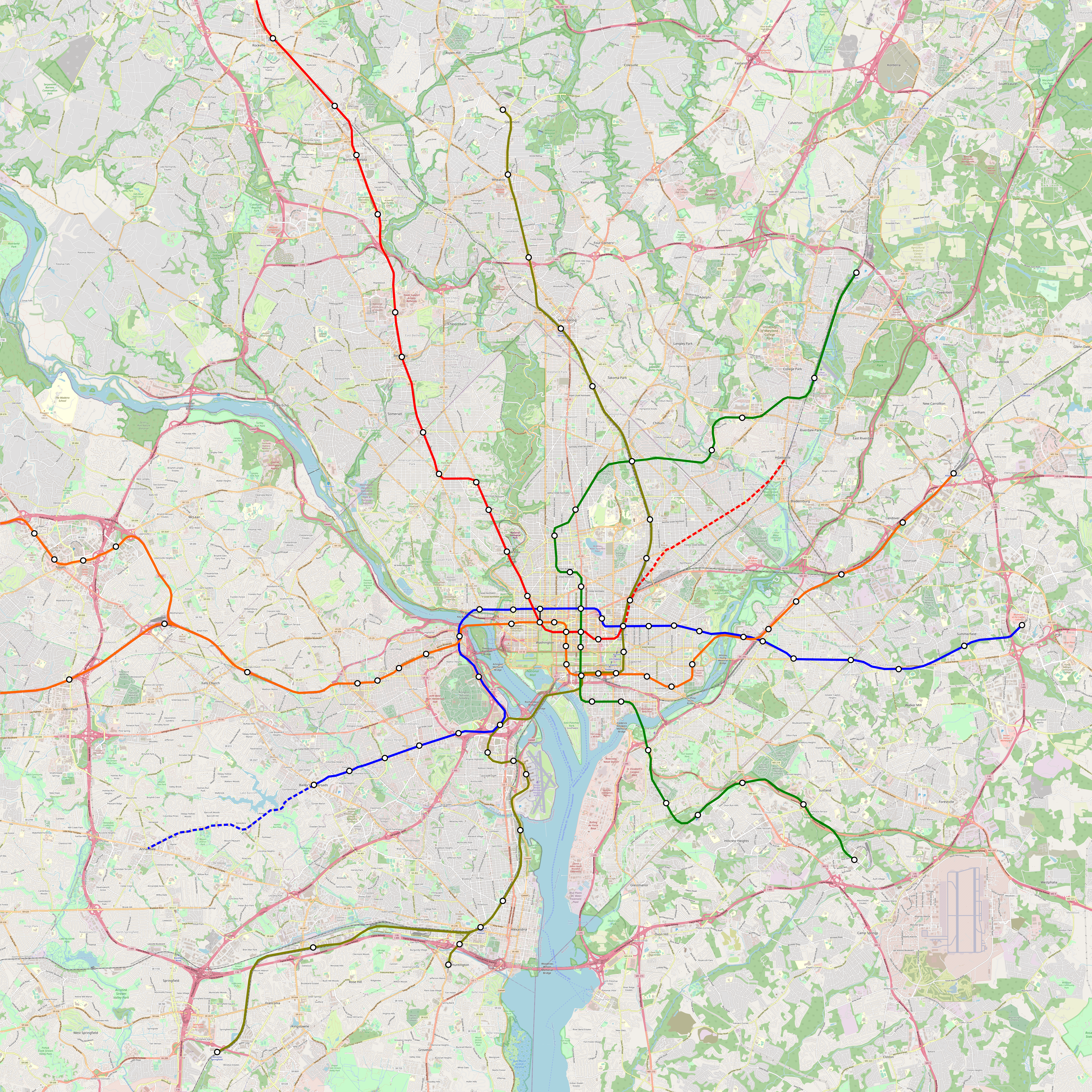
A $10 billion budget should be spent predominantly on new Metro Rail lines, carefully chosen to satisfy multiple goals at once: physical expansion of the reach of the system, additional core capacity, and deinterlining to improve reliability and increase the capacity of existing lines. For the purposes of the question I posed to area advocates, I set the expansion budget at $7.5 billion, good for 30 km at average global prices, leaving the rest for commuter rail improvements.
What to do about commuter rail
Washington does not have a large legacy commuter rail network, unlike New York, Chicago, Boston, or Philadelphia. It is not as old as those cities, and its conception as the southern end of an East Coast region stretching up to Boston is postwar, by which point investment in passenger rail was largely relegated to the past. Nonetheless, it does have some lines, three to the north as the MARC system and two to the south as the VRE system. They should be upgraded to better commuter rail standards.
Union Station already has the infrastructure for through-running. The junction between the through-tunnel and the terminal tracks is flat, and almost all intercity trains terminate and most will indefinitely no matter how much investment there is in high-speed rail to points south. This requires delicate scheduling, which is good up to about 18 trains per hour in each direction, either six through- and 12 terminating or the other way around. Running half-hourly all-day service on each of the lines, with some additional urban overlay in Virginia and extra service on the Penn Line to Baltimore, should not be too difficult.
Thus, the main spending items on the agenda are not new tracks, but electrification and high platforms. MARC runs diesel trains even under catenary on the Northeast Corridor, which problem requires no additional electrification to fix, but its other two lines are unelectrified, and VRE has no electrification infrastructure. Those lines total 327 route-km of required wiring, with extensive single-tracking reducing per-km cost; this should be around $600 million. But note that they all carry significant freight traffic, and additional accommodations may be necessary.
As far as platforms go, there are nearly 50 stations requiring high platforms (I think 49 but I may have miscounted). At Boston costs it should be $1 billion or a bit more, but that’s for long trains, and MARC trains are not so long, and a system based on shorter trains at higher frequency would be somewhat cheaper. Infill stations are probably unnecessary – there are Metro Rail lines along the inner sections of most of the lines providing the urban rail layer.
Metro Rail expansion
The most pressing problem WMATA’s trains have is poor reliability. Two changes in the late 2000s and 2010s made the system worse: the 2009 elimination of automatic (though not driverless) operations worsened ride quality and reducing capacity, and the 2014 opening of the Silver Line introduced too much interlining reducing both reliability and capacity. WMATA is aware of the first problem and is working to restore ATO; the Silver Line’s problems should be fixed through judicious use of deinterlining. Deinterlining by itself only requires a short extension of the Yellow Line to separate the lines, but it can be bundled with further expansion.
Consensus among area advocates is that there should be separate tunnels for the Yellow and Blue Lines and a new trunk line under Columbia Pike, which three lines total 21 km. Additional lines can consist of another trunk line going northeast from Union Station between the Brunswick and Camden Lines or an extension of the Columbia Pike line from Bailey’s Crossroads, the present outer limit of high density, to Annandale, which would require extension transit-oriented development along the line.
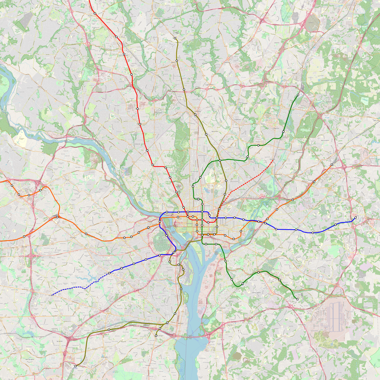
A full-size version can be found here; note that the lines at Union Station are moved around to get rid of the Red Line’s awkward U-shape. The northeast extension option is colored red but should be a Blue Line extension, but the Red Line taking over H Street and going to Largo.

DC Was founded in 1790, Chicago was founded in 1830. Not to mention that the two important colonial ports of Georgetown and Alexandria already existed when DC was founded and enveloped them.
Anyway, besides that lol, we desperately need a line down Columbia pike. It was actually one of the original routes discussed in the 60s, but it was never built, yet a stub was left off the pentagon metro station incase it was built in the future.
Sure, but when most railroads were built, in the second half of the 19th century and very early 20th century, Chicago was a lot bigger.
This requires delicate scheduling, which is good up to about 18 trains per hour in each direction, either six through- and 12 terminating or the other way around.
Amtrak and NJTransit manage 23 an hour in New York. Amtrak could ask Amtrak how they manage to do that. There is space for four tracks all the way to West Baltimore. And plenty of space in Ivy City to build a flyover/duckunder or two. In 2109 when they need the capacity.
The North River Tunnels don’t have a flat junction with a terminal station.
You whine perpetually about how the LIRR and NJTransit don’t run through.
Yes, and if they do, there will still be no such flat junction.
There is space for four tracks all the way to West Baltimore and they can do something with flyovers or duckunders to organize trains someplace other than at Union Station. In 2109 when they need the capacity.
NJT does run through from an operational if not a service perspective. For NJT Penn Station is the last stop but not a terminal station; trains run through the East River Tunnels and are stored or turned around in Sunnyside Yard in Queens rather than reversed at the platforms.
Some of them not all of them. There is that pesky pesky Long Island Railroad using the East River tunnels.
Maybe the tails of the Blue and Yellow lines should be switched south of Pentagon, so that there is a one-seat ride between Rosslyn and Alexandria?
I think this is preferable because:
1) Alexandria etc needs rail access to Tysons Corner etc more than Columbia Pike does, because Columbia Pike is already close to the Orange/Silver Line and a short bus trip to the Orange/Silver Line would be faster than a rail connection.
2) The current Yellow Line as you describe it duplicates VRE service along its whole length, which is wastefully redundant.
I concur. Two more reasons for this:
1. Politically it’s bad to rob Alexandria of its existing one-seat ride to Farragut. Alexandria is going to lose one-seat ride to Metro Center whether or not we switch Blue and Yellow, so do we have to enrage them further?
2. Population-wise, Alexandria deserves more than Columbia Pike to have a one-seat ride towards Rosslyn or Georgetown or Farragut.
Not a DC expert, though spent a good amount of time there, but what do think of instead turning the red line southeast, where there’s a bit of a rail desert? Go through Capitol Hill (with Stanton Park and Lincoln Park as cheap places to build stations, FTA rules about digging up parks notwithstanding), then a transfer at Potomac Ave and across the Anacostia with a stop at Minnesota and Naylor, and maybe one at Alabama and Naylor. More service to the NE of Union Station makes less sense in a world with more frequent MARC and VRE through-running .
DC citizen and regular Metro rider here.
I understand where you are coming from, but your proposal is not a very good idea given the actual geography and density of DC. Capitol Hill is all low-rise residential rowhouses that are protected in one of the largest historic districts in DC. The only commercial corridors in the area that really need Metro service are Pennsylvania Ave, which is already served by Metro, and H Street/Benning Road, which gains service in Alon’s plan. You are also underrating Union Station as a connecting hub. In particular, it is important to have service from Union Station to points east, which is lacking today and served by the overcrowded and unreliable X2 bus and a poorly-designed streetcar line with curbside lanes prone to obstruction.
Across the river, you correctly identify a service gap in neighborhoods like Fairlawn and Skyland that are between the Green Line to the south and the Blue Line to the north. This gap could potentially be served by branching the Orange Line after Potomac Avenue station and proceeding down Penn Ave to the border with Prince George’s County. However, this area is only moderate density and there is really no density at all once you leave DC. It would be low on the list of Metrorail expansion priorities. I think a more realistic option for this corridor is adding center-running bus lanes and signal priority to Penn Ave from Potomac Ave station all the way to the border with Maryland. In addition to the 30-series buses that already run on this avenue, you would need to add a dedicated and frequent bus terminating at Potomac Ave for the Metro transfer.
Density follows transit access. Assuming you haven’t done something silly with zoning/landmarking that prevents it from happening, then if you build fast transit capacity, the resulting convenience will spur a huge amount of development in the former rail desert. It’s shortsighted to build rail only to where people already live–you wind up greatly increasing the value of already-popular areas rather than creating more land that’s suitable for development.
But yeah, the H street trolley was a farcical waste.
Real estate prices are high enough that density will happen even without transit access, if zoning permits it. Proof: Houston, (despite its low real estate prices by US standards!)
Houston, the fourth largest US city by population, is ranked 150th in density.
Houston started out very low-density, but now it’s densifying pretty fast.
It’s less dense than suburban counties in the Northeast and Midwest.
https://en.wikipedia.org/wiki/County_statistics_of_the_United_States#Most_densely_populated
Houston is actually a prime example of how density isn’t even *possible* without transit. The Katy Freeway is a practically ideal example of induced demand–NYC MTA may be grossly incompetent, but they don’t generally spend $2 billion on a major expansion just to make commute times *worse* for 85% of their riders. And to support even its current density levels, Houston’s CBD requires as much parking as Manhattan’s.
You literally can’t build enough car infrastructure to support a dense city.
And it’s hard to make a case for Houston undergoing a recent major increase in density when around 80% of its tallest buildings (and all of the top 5!) predate the Obama administration.
Also driving on a road with more than ~4 lanes in each direction is super difficult in my experience – too difficult to change lanes for your exit unless you know the road well.
You literally can’t build enough car infrastructure to support a dense city.
29 lanes of I-10, Katy Freeway, isn’t very dense, is it? 29 in all directions, in a few places in Houston, according to Wikipedia. …..Make the building twice as tall you need twice the parking. Instead of towers in the park you have towers in a parking desert. Or towers between very expensive parking garages. That is across very wide boulevards to the other parking garages.
4 lanes in each direction is super difficult in my experience
It’s not just you, it’s everybody.
There are diminishing returns to adding lanes. Add a lane to a two lane highway you don’t get 50 percent more capacity. I’m not a traffic engineer. A professor of traffic engineering would be able to say where, generally if not in a specific case, it doesn’t help much and it should be separated into a dual- dual configuration. Local/Express, cars/trucks, Downtown/Midtown and through, something other than lanes and lanes of mayhem. Dual/dual has bigger interchanges.
Nobody works, shops or parks in an interchange. From the satellite images, not even in New York City, do people picnic in the grassy fields inside a cloverleaf ramp.
It’s nice to see that even the WMATA agrees that it can cost effective to dig a second Potomac crossing. No more whining about digging tunnels under a river. (https://www.wmata.com/initiatives/plans/BOS-Concepts.cfm)
And I wouldn’t give a priori preference to Annandale or Hyattsville. It’s better to see which neighborhood has potential for redevelopment and then try to recreate the boom of Columbia Heights.
As for the Yellow Line in DC, I would have it take the following route (next to VRE and then under the Mall) which avoids some awkward curves and saves the cost of building 3 tunneled stations in already served areas.
Do we know there are no secret tunnels there to be avoided?
Good question, though one could ask the same about Alon’s routing (which actually crosses the Senate people mover ROW).
Space is three dimensional. just like there are things above the people mover there can be things, other than dirt and rocks, below the people mover. It’s vaguely the main reason there are subways. There are other things in the way of putting the tracks on top of the dirt. Whether or not someone wants to do that is different question.
Assuming there is an equivalent to https://en.m.wikipedia.org/wiki/Metro-2 in DC the government might want the metro well away from that. Otherwise the mall would have been a good place for a metro line you know.
If they tell you to stay away from it, it’s no longer secret.
The Mall would be a terrible place to put a subway. It’s a long walk across it and there are never going to be skyscrapers around it. And a terrible place to put secret tunnels because it’s long walk across it to places that aren’t alternates for the place the purported tunnel would start.
Hi Alon,
I’ve long enjoyed reading your posts and tend to think your ideas are fundamentally correct. As a DC resident and daily Metro commuter, I do think you’ve misidentified a handful of investments. At risk of being obnoxious, I’m going to write an (annoyingly) long comment about what I think DC ought to do instead.
First off, you need to assess where Metro coverage and capacity falls short with more precision.
There are only two places in the DC area that see a capacity shortfall: from the Shady Grove branch of the Red Line into Downtown, and from Ballston into Downtown. There just aren’t capacity problems on Green/Yellow south of L’Enfant Plaza, and separating Yellow from Green isn’t worth prioritizing over new Metro Rail service on key corridors *within* the District of Columbia. I’m concerned that your H Street and Yellow/Green separation fall into the “crayoning” pitfalls you’ve identified in that they look nice on a map but don’t actually serve underlying demand particularly well. Undoing the reverse branch of Yellow/Blue is worthwhile, but that’s a separate issue. Sending 12 TPH towards Arlington and 12 TPH towards Anacostia is fine. Doubling that…just isn’t very important. Similarly, sending yellow east of L’Enfant Plaza is counterproductive. Gallery Place is already east of DC’s center of gravity. There are basically four destinations east of Gallery Place/L’Enfant Plaza: Union Station, the Senate Office Buildings, NoMa, and the House Office Buildings. Having people transfer to Union Station or Capitol South is not a problem–as all trains from the west have already dropped off most of their passengers. There is spare capacity towards the Hill, so capacity needed for that transfer is a “freebie.” The Hill does not need a north-south Metro line. Keep yellow and green as branches of the core north-south line. It’s not a problem.
Fixing Shady Grove and Ballston is an issue of those lines doing double duty. They serve core urban destinations (Woodley Park, Friendship Heights, Clarendon, Bethesda, Rosslyn) and serve as commuter rail to the far exurbs in ways other lines just don’t. Ashburn and Gaithersburg are *really* far from Downtown DC, and serving them with metro was a mistake. This is where regional rail comes into play. Selfishly, I would love that new blue line alignment. I commute from the West End to Union Station, and losing the Metro Center transfer would drop my commute from 15 minutes to 8 minutes. That would be nice. But objectively speaking, it’s a suboptimal alignment. Missing a Red Line transfer is unacceptable. The biggest benefit of that route would be a station at 14th Street–which is weirdly missing on your map.
Instead of separating out Blue from Orange/Silver, I would suggest using the opportunity of a second east-west tunnel through DC to separate out Metro style services from what should rightly be regional rail services. Terminate the Orange Line at Ballston. Divert trains from Vienna and Ashburn along an express alignment in the I-66 right of way (very cheap) to Rosslyn, then across Downtown to Union Station. They can take over Penn Line services to Baltimore. This wouldn’t cost more than the Blue Line diversion. It would cut trips to Fairfax and Loudon County by upwards of 10 minutes. 12TPH from Ballston on Orange and Alexandria on Blue would be sufficient.
If you want to be clever and serve Georgetown, you can build a new tunnel from Rosslyn to Farragut West via Georgetown and the West End. Send Orange/Blue through that and then onto the I Street tunnel to McPherson Square. Keep express trains in the existing tunnel to Foggy Bottom, then split onto a new H street tunnel east to Union Station at 21st. The engineering for this might be complicated.
To fix the Red Line, use the MARC Brunswick line. Terminate the Red Line at Twinbrook, moving service from Shady Grove and beyond onto RER-style service to Union Station. Through-run to Manassas and Fredericksburg. This can displace Blue Line service to Franconia-Springfield and allow all Metro trains to terminate at Huntington. This would
1. Create a north-south and east-west RER line
2. Decongest the two sections of Metro that are actually at capacity
3. Shorten journey times from Metro stations outside the Beltway to Downtown.
If this is done, you end up with this service pattern:
RER 1a: Ashburn/Dulles/Tysons to Baltimore via Rosslyn and Union Station
RER 1b: Vienna to Baltimore via Rosslyn and Union Station
RER 2a: Germantown/Shady Grove/Twinbrook to Manassas via Silver Spring, Union Station, Crystal City, and Alexandria
RER 2b: Germantown/Shady Grove/Twinbrook to Franconia/Woodbridge/Fredericksburg via Silver Spring, Union Station, Crystal City, and Alexandria
Red Line: Twinbrook to Glenmont
Orange Line: Ballston to Largo
Blue Line: Huntington to New Carrollton
Yellow Line: Pentagon (eventually Columbia Pike) to Greenbelt
Green Line: Branch Avenue to Greenbelt
Purple Line: Bethesda to New Carrollton
Once you’ve done this, the question becomes–what parts of the DMV Region don’t have enough Metro service. You’ve identified two–Columbia Pike and H Street. This is correct, but incomplete. Based on density and bus ridership, I would prioritize as such:
1. Georgia Avenue between Petworth and Silver Spring
2. The southwest-northeast Axis between the Golden Triangle and Columbia Heights, including in its study-area Farragut Square, Dupont Circle, Adams Morgan, U Street, and the 14th Street Corridor. This is of particular importance because of how awful the connections are between Farragut Square and the Yellow/Green corridor towards Greenbelt.
3. Columbia Pike
4. New Hampshire Avenue from Fort Totten to White Oak
5. H Steet Corridor
6. Key underserved points for infill stations: The Wharf, Eckington, Georgetown, etc.
(1/2)
Georgia Avenue is *so* important. The Red Line through Fort Totton is just useless for these places. It’s dense, densifying, and busses are slow. Generally speaking, the swath of land from Downtown DC to Silver Spring is the most “urban” area on the East Coast outside New York. Diverting southbound trains from Takoma into a new tunnel through Brightwood and Petworth would be incredibly useful. The question becomes what to do with Green/Yellow and Red. This is where priority #2 and priority #4 are relevant. At Fort Totten, send the Red Line northeast through Langley Park to White Oak. The RER will already serve Silver Spring-Union Station trips better. Continue the Georgia Avenue Line south through Park View and Howard University and tie it into Yellow/Green at Shaw. As for Yellow/Green, sever the segment along U Street. Send trains from Columbia Heights to Farragut Square. There are a number of possible alignments–New Hampshire, Florida, U, 19th, 18th, etc. A more detailed analysis is needed. But generally speaking, this would improve connections between the densest neighborhoods of DC and the actual core of the city–which is a corridor that literally has zero service today. Do this and you end up with:
RER 1a: Ashburn/Dulles/Tysons to Baltimore via Rosslyn and Union Station
RER 1b: Vienna to Baltimore via Rosslyn and Union Station
RER 2a: Germantown/Shady Grove/Twinbrook to Manassas via Silver Spring, Union Station, Crystal City, and Alexandria
RER 2b: Germantown/Shady Grove/Twinbrook to Franconia/Woodbridge/Fredericksburg via Silver Spring, Union Station, Crystal City, and Alexandria
Red Line: Twinbrook to White Oak
Orange Line: Ballston to Largo
Blue Line: Huntington to New Carrollton
Yellow Line: Pentagon (eventually Columbia Pike) to Glenmont
Green Line: Branch Avenue to Glenmont
NEW LINE: Farragut Square to Greenbelt
Purple Line: Bethesda to New Carrollton
This is probably exhaustive for a medium-term plan, but future projects could take the Farragut-Greenbelt line by the Kennedy Center to Pentagon and onwards to Alexandria. This would allow Rosslyn-Pentagon to finally become a shuttle and allow a full 24TPH to Ballston. Serving H street is awkward, especially considering the lack of need for more than 12 TPH to Largo or New Carrollton. My instinct is to say some branch of RER1 could send trains to H Street, Stadium-Armory, Historic Anacostia, Naylor Road, and Branch Avenue, then continuing to Charles County along the alignment presently proposed for light rail. You could then reroute Green from Naylor Road, perhaps to Fairfax Village and Forestville.
For some of these routes, (proper) tram service isn’t inappropriate. The DC Streetcar with dedicated lanes and a better Union Station transfer would be *fine* for H Street. The same goes for Wisconsin-M-Pennsylvania-K for service to Georgetown. A tram from Navy Yard-Capitol Hill-Union Market-U Street-Adams Morgan-Woodley Park *in dedicated lanes* would also have genuine positive transportation value along *the* definitive orbital route of DC’s inner residential areas.
(2/2)
Silver Spring is the most “urban” area on the East Coast outside New York.
No it’s not. The Census Bureau publishes population density numbers. Philadelphia’s was 11,379 in 2010 and D.C.’s was 9856. There are lot of suburbs with densities like that along the NEC. If you want to start picking neighborhoods the densest one is Friendship Village which in on the Northwest border of D.C. not the Northeast.
Re Yellow/Green: I think you are correct that moving the Yellow Line east would be unnecessary in terms of capacity, and probably of negative usefulness due to missing the core CBD. I suggest this as an alternative, built in the following stages:
1) The Yellow/Green share tracks as far north as Shaw-Howard, then the Yellow branches off to follow Georgia Ave to Silver Spring
2) The Yellow takes over the Red Line north of Silver Spring. The Red is redirected to a new White Oak extension. Takoma loses its Red Line station, but a MARC station is built there.
3) If someday the Yellow/Green shared tracks get too congested, then the Green can be redirected on the dotted path.
I certainly see the logic in that! I don’t know if it’s better to split at Shaw or Petworth, but it makes sense. I also think you could have the tunnel emerge around Montgomery College and follow the existing Red Line ROW through Silver Spring, rather than tunnelling that extra 1/2 mile and reconstructing Silver Spring Station. I don’t think, however, that I would support that hypothetical Green redirection to Metro Center considering the demand further west (Dupont, Farragut, etc.) Gallery Place and Metro Center are already just a 4 minute walk apart.
Re the redirected Green Line – it has to go to either Metro Center or Farragut in order to have a transfer with the Orange/Red lines. I am open to either, but if the transfer were at Farragut the Orange Line east transfer would be bad, a lot of backtracking would be required. Maybe the answer is for the Green Line to go north to Smithsonian, then head northwest to Farragut for a second Orange Line transfer. Or else it could stick with the Orange Line as far as Metro Center, then head northwest.
Note that while Columbia Road is very built up, it is also a circumferential. So maybe the best solution for it is a frequent bus connecting to the metro, rather than making a radial metro line do some circumferential curving. Maybe there should be an infill Red Line station at Connecticut&California to help with this.
“The Red is redirected to a new White Oak extension. Takoma loses its Red Line station”
A line from Silver Spring to White Oak is fine, but if re-directing the Red Line why would Takoma lose its station? Why not send the Red to White Oak *from* Silver Spring instead of from Fort Totten (is that what you meant?). White Oak to SS is 4.2 mi vs 6.6 mi down New Hampshire Av to the Red Line, plus I’m pretty sure people in White Oak would want to be able to take Metro to Silver Spring (which is a major urban destination in its own right) rather than say Adelphi.
If the goal is to serve N Hampshire/Langley Park, the correct move is to Branch the Green before Fort Totten and continue up N Hampshire.
The goal is not just to serve White Oak, but also the road leading to White Oak, whichever that is. It seems to me the New Hampshire ROW has more current and potential travel demand than the Colesville Rd ROW, and thus should probably be preferred even if it’s a bit longer. But I am flexible on this point.
New Hampshire inside DC to Langley Park has good current and potential demand, but you should look at a satellite view of Adelphi and Hillandale before making that assumption of the whole road. Note that branching from the Red to N. Hampshire leaves a metro gap of ~1.9 mi in the densest part of the road, the part inside the district past Petworth. Better to serve NH by branching from the Green, with a Manor Park station interchanging with the Red (with a possible Brightwood Park station in between, but half of the walkshed is cemetery).
Colesville Rd is not spectacular but it is shorter and if combined with NH people in White Oak and Langley Park could access not just downtown but also Silver Spring and 14th/U St corridors with a direct transfer, instead of going all the way into downtown on the Red to backtrack on the Yel/Green.
“Based on density and bus ridership, I would prioritize as such:
1. Georgia Avenue between Petworth and Silver Spring”
I was very surprised to see Georgia Av omitted in Alon’s post. Although Adirondacker is correct that it is not (and nowhere near) ‘the most “urban” area on the East Coast outside New York’ it is one of the most urban areas in the metropolitan region and certainly the most urban without continuous metro service. Before Covid, the six bus lines serving the corridor on 16th, 14th, and Georgia Av combined for 13% of all ridership across the entire WMATA system (with 269 routes serving DC, Maryland and Virginia). This year the lines make up just under 17% of total ridership, meaning the corridor is recovering faster.
Before Covid those six lines saw 38,000 riders over 7.4 miles from downtown DC to Silver Spring, or 5,135 riders/mi, just on busses. For comparison, MetroRail saw 6,980 riders per mile that year, and that bus corridor had higher ridership per mile than BART or MARTA.
Having the Yellow or the Green branch to go due north from Shaw should be a higher priority than a new line down Columbia Pike. Columbia Pike saw only 3% of WMATA bus riders among all variants of the 16 busses, and has dropped to 2.7% now. Riders per mile was only about 2,000-2,300 out to Bailey’s Crossroads. If there is enthusiasm in the Twittersphere for Columbia Pike it is probably because there was a proposal for a streetcar there a few years back that was killed by county politicians, so it is a bit of a cause celebre among transit followers in the region.
I picked Philadelphia because it got consolidated. Boston annexed this that and other thing but didn’t go in for consolidation on the scale of Philadelphia or New York. Boston’s population is almost the same as the District’s and Boston’s density is 12,792. The green leafy suburb I lived in for many years has a higher density. That isn’t in Maryland. I could go on. The Census Bureau publishes density number and they are almost trivial to find.
You’re looking at this on too granular of a level. I’m talking about larger swathes of land. The north-south corridor from K Street to Silver Spring, bounded on the west by Rock Creek and the east by the Soldiers’ Home area has about 280,000 people in 11 square miles. That’s 25,000 people per square mile over a continuous, linear swath of land. There are other places that are denser–but which cover a much smaller area (South Philly+Center City, etc.) I’m not aware of anywhere else on the East Coast outside New York that is continuously built to a density of over 25,000/square mile which covers that much land.
@spencepatrickj, where are your figures from, I do not think they are correct. 2021 estimates for all of Wards 1, 2 and 4 is only 270,000; but this includes many people outside the Georgia Av corridor (Ward 2 is all of downtown plus Georgetown, Ward 4 goes W of Rock Creek and E of Soldier’s Home).
Nor is the corridor particularly large. South Philly + Center City is larger at 17.4 sqmi, and dense urban fabric continues through Lower North Phila. before SFDs and hollow blocks begin (for that matter Georgia Av isn’t continuously dense, Takoma and Shepard Park are all detached housing).
Adirondacker is correct, there are east coast cities beyond NY with larger/denser neighborhoods. You don’t need to oversell Georgia/14th/16th for Metro, it stands deserving on its own.
Add in Silver Spring itself. Built-up South Philly+Center City is about 6.5 square miles. Most of that land is industrial.
Boston is not particularly granular and it has the same population as the District. If you don’t like Boston there’s Hudson County New Jersey that is denser than Boston. That isn’t accurate because there is a big swamp in the middle of the county where almost no one lives.
Onux, he also has to tell us what his definition of Silver Spring is because it’s not an incorporated municipality. It differs depending who you ask what it is. Even the Census Bureau changed it’s mind about that between 2000 and 2010.
@spencepatrickj
Adding Silver Spring still leaves your figure inaccurate. If Silver Spring means the downtown core, total census tracts in your definition (from https://mtgis-portal.geo.census.gov/arcgis/apps/MapSeries/index.html?appid=2566121a73de463995ed2b2fd7ff6eb7) gives a population of 209,165 in 12.755 sqmi for 16,399/sqmi, or 75% of your claimed population and 65% of claimed density. This number is probably high; census tract limitations include some people south of K St, some east of the RR line, and some far from downtown Silver Spring (because density drops off quickly, some tracts partially in the walkshed also stretch well north of it).
Philadelphia between Packer and Lehigh (excluding industrial land along the waterfront) is 16.1 sqmi, and a non-exhaustive search of census tracts shows all but a handful are denser than 16k/sqmi, so it is not only larger but denser. Plus see Adirondacker’s examples of Boston, and Hudson County.
Georgia Av is still an *excellent* candidate for a Metro line: a linear corridor, high density (yes, 16k is high), connecting the regional core to a satellite downtown, with high existing bus ridership. There is no need to oversell it as larger or denser than it is.
….There’s Staten Island which has a similar density as the Silver Spring CDP. Like Hudson County it had a big swamp that got partially filled with Mount Trashmore/NYC landfill which is a park. So is the remaining swamp. And almost half million people.
Out of the 20 densest counties other than those in the New York City area most of the rest are in the Washington DC area to be fair.
There are 5.2 million people in Cook County, Illinois and 6.2 in all of Maryland.
I think Columbia Pike (in Virginia – not the one that goes through White Oak!) gets attention from transit activists not because of the streetcar, but because it allows elegant deinterlining of the Blue/Yellow lines. Also it seems ripe for high density TOD like in Silver Spring or Rosslyn, which (probably unfortunately) is not practical within DC itself.
Something I think is worth building, but hasn’t been mentioned, is a Purple Line extension to Tysons Corner. It would give much better connectivity between the edge cities of the region, and eliminate some trips through the center.
The first few km would be built on the existing Capital Corridor ROW. The rest would have to be tunneled (except the river crossing which would be on a new bridge), but the tunnel would probably have few to no stations (as the Dolley Madison Blvd suburbs would probably refuse the upzoning needed to justify a stop, and the CIA might dislike transit access) which would make it cheap by tunnel standards.
A bit off topic, but this *finally* happened for what it’s worth (subscription required): https://www.washingtonpost.com/transportation/2022/06/23/metro-silver-line-dulles/
Not sure why you believe WMATA could spend $10 billion wisely. It is a bloated organization that pays inadequate attention to rail safety and has overly generous loading standards that it generally ignores to run even more underutilized trains.
The problem with WMATA isn’t that it runs too much service, it’s that it runs too little – urban rail at 12-minute frequency is not desirable.
Could you provide further elaboration on how this improves on your previous proposal for retrofitting the dc metro? (Link: https://pedestrianobservations.com/2017/12/29/what-washington-metro-should-build/)
Also, did you take into account other hypothetical DC metro proposals, such as the one made by Reddit user twoninehigh? (Link: https://www.reddit.com/r/TransitDiagrams/comments/hevzgm/comment/fvtu8b9/)
Finally, beyond this current expansion, what other expansions would you make to the DC metro, assuming price was no object?
My previous proposal is a lot more parsimonious; this is the equivalent of my Assume Normal Costs post but for Washington, the budget in effect acting as a counter to the (now more expensive) proposals to rebuild Union Station.
They want to turn Union Station D.C. and Penn. Station Baltimore into airport terminals. For billions of dollars. So they can use the spectacular early 20th Century passenger spaces for a mall.