Mixing Circumferential and Radial Transit in the Other Direction
Two years ago, I wrote a post criticizing subway lines that mix radial and circumferential elements. These lines, for examples Shanghai Metro Lines 3 and 6 and New York’s G train before 2001, contain long radial segments, going from an outlying neighborhood toward city center, but then switch to circumferential mode, avoiding city center and instead serving secondary nodes. Such lines do not get high ridership, because they fail at either radial or circumferential transit. Recently, I was challenged in comments about my support for a mixed line that goes in the other direction: circumferential on the outside, radial on the inside. I would like to talk more about such lines.
Consider the following diagram of a subway system:
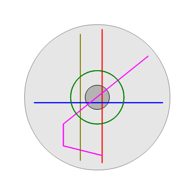
The city is shown in light gray, with its center in dark gray. There are five subway lines: the red and blue lines are straightforward radials, the green line is a straightforward circumferential, the yellow line mixes radial and circumferential as criticized in my previous post, the pink line mixes radial and circumferential in the other manner, which I will describe in this post.
The reason the yellow line is going to underperform in this system is that it fails as a radial: it does not go to city center, which has the largest concentration of destinations for transit users. People who have equal access to the red and yellow lines, north and south of city center, are much likelier to choose the red line, which takes them where they want to go. The green line fails as a radial too, but has the positive features of a circumferential: it only serves relatively nearby neighborhoods, which are likely to be denser and produce more riders per unit length; it connects to every line in the system; it allows people to connect between two radial lines without going through the congested city center; it has no dominant direction at the peak, so trains are unlikely to be full in the peak direction and empty in the reverse-peak direction. The yellow line has none of these features, unless one wants to connect between the western legs of the blue and pink lines.
The pink line still works as a radial. Its northeastern leg is a straightforward radial, but even its southwestern leg works as a radial for people who live west of the yellow line and wish to commute to city center. In this way, it is not truly a mixture of radial and circumferential elements the way the yellow line is, but is simply a radial with a circumferential element tacked on at the end.
Whether the pink line’s circumferential tail works must be evaluated against two alternatives: build nothing, and build a radial leg. This is because in an incrementally-built transit system, the radial parts of the line are typically built first, and the circumferential tail is tacked on as a later extension. In the no-build case, the pink line’s southwestern leg would simply be shorter than the other radial legs in this system. In the radial case, the pink line’s southwestern leg would look symmetric with the northeastern leg. This depends on the following factors:
- The strength of the radial alternative. If the radial alternative is strong, then this discourages building the circumferential extension, and vice versa. The radial alternative can be weak in several ways: the southwestern quadrant of the city depicted above may be already replete with radial transit and not need more; the population density in the neighborhoods that would be served by the radial option may be low; and the city’s layout may not be the above-depicted perfect circle, so that there is nowhere for the line to turn except sideways.
- The strength of the corridor that would be served by the circumferential leg. The leg can never be a complete circle, so it must be evaluated as a rapid transit line on an individual street or corridor. This far out of city center, transit demand on each route is unlikely to be high, but there may well be exceptions, for example if there is a linear secondary CBD. For example, while Seoul Metro Line 2 is fully circumferential, one of its segments follows a Tehran Avenue, a major street in Gangnam with high transit demand, which would justify a subway even if it weren’t part of a large circle.
- The strength of the circumferential transit demand from the end of the potential circumferential extension to the radial segment. In the depicted city, there may be strong demand for east-west transit south of the CBD, and the circumferential pink line is then better at serving it than connecting between the red and yellow lines via the blue line.
The original impetus for this post, as noted at the beginning, is a comment challenging me for my support of an extension of Second Avenue Subway Phase 2, going under 125th Street from the planned terminus at Lexington Avenue to Broadway, with stations at the intersection with each preexisting subway line. I contend that in this case, all three factors above point to a very strong circumferential extension. In order:
- The radial alternative is to extend Second Avenue Subway to the north, to the Bronx, presumably under Third Avenue, but according to some railfans also under University Avenue. This is problematic, for three reasons. First, the Bronx already has many north-south lines feeding into Manhattan trunk lines, with mediocre ridership. The Manhattan trunk lines are overloaded, but mostly with traffic coming from the Upper East and West Sides, Harlem, and Washington Heights. Second, Third Avenue is close to the Harlem Line, which could be used for local transit if fares and schedules are integrated with the subways and buses. And third, the plan for Second Avenue Subway is for the line to turn west at 125th toward Lexington, since 125th and Second is not as compelling a destination, and this makes it easier to extend the line to the west than to the north.
- 125th Street is a very busy street, and acts as the main street of Harlem. Transit demand is high: four bus routes use the street, with a total of 32,630 boardings per weekday on 125th Street, exclusive of other segments of those routes. This count misses people who board elsewhere and get off on 125th, but conversely assigns people who board on 125th and get off elsewhere to this street and not the other segment. But with this caveat in mind, this points to about 11,000 weekday riders per route-km, ahead of New York’s busiest bus per unit length (the M86, with about 7,000), and not far behind the subway average (15,000). This is despite the fact that, in my experience going between Columbia and the Metro-North station at Park Avenue, those buses are not faster than walking.
- East-west transit in Uptown Manhattan consists of Pokey-winning crosstown buses; the 125th Street buses are as slow on 125th. An underrated feature of Second Avenue Subway Phase 1 is that it will soon enable a two-seat subway ride from the Upper East Side to the Upper West Side, West Harlem, and Washington Heights. However, this option will require connecting at Times Square, and is useful mainly for people in the southern areas of the Upper East Side connecting to the 1/2/3 rather than to the A/B/C/D. A two-seat ride based on going up Second Avenue to 125th Street and thence connecting to the 2/3, A/B/C/D, or 1 would enable more connections, many without any backtracking. This could have a potential cascading effect on all Uptown east-west buses, and not just those using 125th Street.
Of course, a Second Avenue Subway extension on 125th Street cannot be exactly like the pink line in the diagram above, because a key feature of it is that the circumferential part is not in fact near the outer end of the city. It’s barely 5 km north of the northern edge of Midtown, not even halfway from Midtown to the northern ends of most preexisting north-south subway lines. This is how it can have such high residential and commercial density and strong transit demand. Much farther north, Fordham Road is a very strong bus corridor, with about 4,500 weekday riders per route-km on the Bx12, but this is at much higher speed than in Manhattan, about 13 km/h rather than 5 km/h. An extension of the A east toward the Bronx under Fordham would underperform, because Fordham just doesn’t have that much demand; but 125th does.
The result of this discrepancy is that in a small city, one whose subway system is only about as large as in the diagram, it’s unlikely that such circumferential extensions would work. A radial line built all the way out is going to have as its terminus either a relatively low-density area or an anchor point, such as a commercial center or big housing project, neither of which lends itself to a strong continuous circumferential corridor. A radial line built part of the way to the edge of the city could potentially find a Tehran Avenue or a 125th Street, but if the system is small, with many key outlying neighborhoods still unserved, then it is usually best to keep extending lines outward.
The factors that conspire to make a 125th Street subway extension work are in place precisely because New York already has a large, mature subway network, in which Second Avenue Subway is a relief line. Certainly the projected demand on Second Avenue is very high, but the East Side is already served by a north-south subway 500-600 meters to the west of this line; it’s being built because this subway is overcrowded, not because the East Side has no access. This means that there’s more leeway with choosing what to do with the line once it reaches Harlem – after all, the Bronx subways are not overcrowded, and do not need relief.
Whereas mixed lines like the above-depicted yellow line are always bad transit, mixed lines like the pink line, in which the circumferential part is farther out than the radial part, are potentially an option for large cities that already have many rapid transit lines. They are especially useful for providing connections between closely parallel radial lines when other crosstown transit options are slow, and should be considered as extensions for relief lines, provided the radial lines farther out do not need relief as well.
Update 2018/2/25: the Jubilee line extension in London is a good example of what I’m describing in this post. The Jubilee line is mostly a northwest-southeast radial line, but to the east of Canary Wharf it heads north to Stratford. The radial alternative would be strong (one of Crossrail’s branches is going to provide it, 20 years after the extension opened), but the circumferential option is even stronger: Canary Wharf is an office cluster and one of the Underground’s busiest stations, and needs rapid transit service from all directions, not just east-west as a pure radial would provide.

One interesting thing you could do with a 125th avenue subway is turn it northbound and connect it to the 8th Avenue Line. From there, C train service could run from 168th to 145th, then use the layup tracks between 145th and 125th to build a flying junction connection to a 125th line with stations at Lenox (2 3) and Park/Lex (4 5 6 and MNR) before continuing in to the SAS.
This would require about one mile of tunneling from Park/Lex, two stations, but would use an existing terminal and layup yard past 168th St. Without this, there would have to be a new such yard built somewhere on the West Side in the vicinity of 125th St, which wouldn’t be cheap. (Linking in to the Broadway Line is a non-starter both because it’s A-division and at a much higher grade at 125th St.) You lose a connection to the 1 train and the Broadway Line, but figuring out how to do that from a subway to the much-higher elevated at 125th would be tricky and expensive.
If all C service were rerouted to the east side, there would be a minor loss in connectivity where local riders on the C train from 163rd and 155th would have to transfer to a B train at 145th to access 135th or local stops along the park (although most are already transferring to an express train for the straight shot from 125th to 59th). Service to 50th St would only be possible by going down to 42nd and then back up on an E train. It might make more sense to run both C and B trains to both the east and west sides. They each currently run a 10 minute headway, so every other train could run local on the 8th Avenue Line and across to the SAS (movements through the six-track section at 135th St would be relatively simple with minimal interference with current express movements, although some trackwork might make things smoother; as usual, the IND’s overbuilding would be a benefit).
B and C trains would run down Central Park West on their current routings, Q and T trains would run from, say, 168th and Bedford Park Blvd, respectively, to the SAS. Below 63rd, these could be interlined on to the current Q (7th/Broadway BMT express) or distributed between the IND 6th Avenue Line and the BMT. Further south, in Brooklyn, if the Q and T were interlined it would double headways on the Q local service (I’m assuming that the SAS will require peak headways of 4-5 minutes) so one of the lines could be routed on to a different service, or even the currently-unused Culver Express tracks. (But this is getting in to the weeds.)
Anyway, back to Manhattan: this would allow connections between every subway except the Broadway Line north of 96th to the crosstown/east side service, all for one mile of tunnel without the need to build a new terminal station.
I think it’s worse than just continuing straight to Broadway, for the following reasons:
1. The biggest job center in Upper Manhattan is Columbia; Morningside Heights has 36,000 jobs in 1 km^2. The center is 116th and not 125th, but with the Columbia expansion, 125th and Broadway is likely to become a bigger attraction.
2. The IND already has far too much reverse branching. Complicating this by rerouting the C is only going to make the system even more complex, with implications about schedule adherence and capacity (a delay on one train would propagate to more lines).
3. A terminal station would just have two tracks and no layover yards: the Q has yard space at Coney Island already, and the plan for SAS Phase 1 involves no layover tracks.
Since the issue has been raised, I feel that I have to bring up our favorite variation on this proposed connection between the 125th St. SAS and the St. Nicholas Ave IND. That is, of course, the anti-auto conspiracy to take back some of the lower level of the GW Bridge and run an IND (&/or an SAS) line across to NJ and outbound perhaps to Paterson, NJ, (one might say a birthplace of the Industrial Revolution in the US). As Ari pointed out, ample trackage provision exists, in part because something along these lines was built into the IND plans. This would create a line with a lot of the characteristics of your hybrid pink lilne.
Aside from the formidible task of taking back some of the GW Bridge (and building the largely surface line in NJ), there would only need to be built the connecting tracks from the 174th St. yard to the bridge and the junction with the SAS at 125th St. Personally, I would go for spending the extra $1 billion for an SAS station crossing beneath the IND station at 125th and St. Nicholas and looping the connection to the IND west and north from the west end of that station to the six-track section of IND going north, thus also allowing for the 125th St. line to continue on west if still desired.
As to what trains would run on these tracks to NJ, it would seem logical that the A or C would be one brand, with the other going on to Inwood/207th and a new line, perhaps the J, doing the same Jersey route but taking the SAS south/east of 125th St. This allocation would maintain the current levels of service on the IND lines and use approximately one-half the capacity of the 125th St. trackage, leaving the other half for trains originating at St. Nicholas or west on 125th or later on, if the Bronx extensions are ever built, from SAS trains originating there.
As to continuing the SAS west on 125th St. to Broadway and connections with the 1 line and MNRR, there are some issues, perhaps, and/or some possible alternatives, but it seems to be reasonable enough if technically and economically feasible. First of all, the terrain is not exactly rectilinear, and 125th St. itself follows the bottom of the ‘valley’ that actually opens out to the Hudson at about 130th St, crossing Broadway at about 128th St. I don’t offhand know exactly where the new campus is supposed to be, or whether the 125th St. SAS station would be at 125th St. actual or 125th St. virtual/extended, but in any case the distance to the old campus would be about the same as it would be to a station at 125th and St. Nicholas. The question of the soil may be an issue, I suppose, as it is quite likely that the western end of 125th, if not the whole thing, was originally a streambed and/or tidal marshland – that is probably not a show stopper either, as a lot of the subway is built in places like that.
One mignt imagine a street-running light rail or trolley connecting the two campus locations, if the hill at the 125th St. valley is not too steep. It could conceivably even acquire cachet and or become a tourist success. It could continue south on Broadway at least while Broadway has its central median, using left side doors opening onto the median area. Such a streetcar could complete the journey to the SAS along 125th St. if the SAS were turned or terminated at St. Nicholas. The streetcar could do the 125th St. leg underground if desired, and terminate with a cross-platform transfer at 125th St./St. Nicholas station lower (SAS) level.
The 125th St. line could turn south on Amsterdam/10th, lined up to meet any forthcoming 10th Ave line coming up from say the L on 14th St. Again, depending on exactly where the new Columbia complex is, a station on 125th and Amsterdam might be close enough for the north end and another at 116th or so for the existing campus. Likewise, streetcars along this route might or might not be feasible. The 125th St. line could also be extended straight through to NJ, although some other destination other than Paterson might then be indicated; too bad, as Paterson is apparently (Wikipedia) the 2nd (to NYC) highest population density of US cities over 100k.
The Columbia campus expansion is between 129th and 133th, between Broadway and 12th. 125th Street – the diagonal by that name, not the only street level with East 125th, which is called LaSalle in Morningside Heights – is at the southern end of that area. 125th/Broadway is also closer to the current campus than 125th/St. Nicholas; people from Columbia almost exclusively use 116th and 110th on the 1, but go to 125th/Broadway for a few campus buildings in that area and for Fairway, and go to 125th/St. Nick if they want to take the A/B/C/D and not the 1.
Broadway is a really bad corridor for light rail. Bus ridership is pretty low: the M4 and M104 get a little more than 1,000 weekday riders per km each. The M104 got twice its present-day ridership in 2010, but has been in rapid decline since. Why would anyone take a bus on Broadway when there’s a very frequent subway with short stop spacing? People might want to take a bus heading uphill from 125th to 116th, on the M104/M4 overlap, but in practice, few people do that. The vast majority of transit users in that area are young and able-bodied and have no trouble walking uphill, even with heavy shopping bags from Fairway. Columbia runs bus shuttles between its campuses, with service to those buildings already near 125th, but pretty much nobody uses them; the frequency is terrible, maybe once every 40 minutes, because the vast majority of people who travel between campuses just take the 1.
The idea of leveraging 125th to create more capacity for an extension across the GWB is a lot more interesting. The problem with trying to weave the Q/T between 125th and 168th on the A/C is that, past 145th Street, the tunnel narrows to four tracks. This means that all options become bad in some way:
– Q trains run express and share tracks with the A, T trains run local and share tracks with the C, or vice versa. Local trains take the bridge because that’s where the bellmouth leads to, express trains go to Inwood. Problem: even more reverse-branching than the system already has, with one more place where a delay on one train propagates to other lines. For maximum unreliability, it also happens to involve the longest line in the system, near one of its ends.
– The A/C share the express tracks north of 145th (or even 125th), the Q/T get the local tracks and go to Jersey. Problem: 155th and 163rd lose their through-service to anything on the line north of 168th or south of 125th. Much local/express transferring.
– The A/C share the local tracks north of 145th and go to Jersey, the Q/T get the express tracks. Problem: this cuts the fastest route from Washington Heights to Midtown, namely the express tracks using 8th Avenue. Inwood already has one of the longest average commutes in the city, and this would make the problem even worse than it already is.
If not for the state boundary, I would suggest running west straight under the Hudson (with stops at each of the intersecting north-south subway lines). One stop at Edgewater, one in Ridgefield or Palisades Park, and you’d redistribute all that traffic from Bergen County.
But as long as New Jersey acts like New Jersey, this is just a fantasy.
The problem with this is that as soon as such a line crosses the Hudson, it becomes radial again, and then what’s most important is getting to the CBD as fast as possible. This is especially true given where a line continuing west from 125th would end up – other than Edgewater, these aren’t compelling destinations, so such a line would have to be fed by north-south lines (bus or commuter rail). If there’s money for such a tunnel, it should go to just sending those north-south commuter lines to Lower Manhattan via Pavonia (not Penn Station, since this is a lower priority than four-tracking the North River Tunnels).
An extension that uses the C, the GWB, and Route 4 doesn’t have the same problem, because a) Route 4 hits stronger destinations, like Fort Lee, Paramus, and Paterson, and b) from east of the GWB almost all the way to downtown Paterson, it could be elevated, cutting construction costs.
Psterson already has a train station and someday will have direct service to Midtown. So will all of the other people who would be using the train to get to a transfer station along Route 4.
Thank you, an unusually clean argument.
I agree that when outside the central area of a city, circumferential lines are generally less than optimal.
However, we also must acknowledge that some cities have central areas that are mind-bogglingly huge. I would consider Gangnam/Tehran Avenue to be part of central Seoul, just as I would consider the western half of the Yamanote line to be central Tokyo.
Within these huge central areas, it really doesn’t matter what shape lines take. In Tokyo, L, U, O, and S shaped lines abound and yet they all have high ridership. In fact the irregular shapes of the lines are somewhat beneficial because it allows basically every line to cross every other line at some point, making most trips possible with just a single transfer, even if the routing is not the most direct.
New York is somewhat of an exception among megacities for the geographical compactness and dominance of Manhattan, but even so, you would not be hard pressed to call 125th Avenue part of central New York – so therefore the traditional rules of radial being better than circumferential, and straight/direct routings being better than curved/indirect lines, don’t really apply here.
Just as a brief note: the gods of comment moderation hold the first comment everyone posts for moderation, even if it’s a long-time commenter who uses a new name or email.
125th Street is a pretty central artery, yes, but it is not part of the CBD. Not even close. The biggest job center in Upper Manhattan is Columbia, with about 36,000 jobs in 1 km^2 of Morningside Heights. In Midtown, the job density is 200,000/km^2.
In Tokyo, the dropoff in job density between Hibiya or Marunouchi and Shinjuku or Ikebukuro is much less steep, but it’s still there. There’s also a valley of lower-density neighborhoods in between Central Tokyo and Shinjuku/Ikebukuro/Shibuya; the Namboku Line should probably be added to my list of examples of underperforming lines that mix radial and circumferential elements the wrong way, in that it’s radial to the north and south but passes through less central districts in the center.
I would propose simplifying the principle to read simply that every line should go through at least one area of very high density. I could never be convinced that the Nanboku line is circumferential in any way – circumferential is just the wrong word for it. The term circumferential also carries with it the assumption that cities are monocentric, which many are not.
A secondary principle is that lines that take riders directly and quickly to those very dense areas are better than ones that take a tortured path, but you can get away with doglegs if congestion is bad enough and/or the area is dense enough.
Any argument regarding circumferential vs radial lines would therefore be just an application of the above principles.
Yeah, this typology breaks down in areas that have multiple centers. It’s not quite about polycentricity, because in Tokyo, Paris, etc., there’s still an identifiable single primary CBD. It’s more about the pattern of centers. Tokyo has two centers: a primary one around the Chiyoda/Minato/Chuo tripoint, and a secondary one stretching along the Yamanote Line. New York has two centers, too: Midtown, and Lower Manhattan. So perhaps it’s best to think in terms of lines that pass between these centers without serving either: Namboku in Tokyo, the L in New York. The L is overcrowded because of capacity limits imposed by the western terminal and because of peaky demand, but overall ridership isn’t high – it ranks 7th among the 9 colors in the city, ahead of only the G and the J/M/Z. And the L isn’t far ahead of the J/M/Z.
I dislike phrasing this as “at least one area of very high density,” because this area may be still clearly secondary. The G train in New York passes through Downtown Brooklyn and Long Island City, but as these are clearly secondary, the G is still conceptually circumferential, and has to be rated on the quality of its connections to the radials, which is very poor. The L passes through Union Square and goes under 14th Street, which is the biggest center in Manhattan outside Midtown and Lower Manhattan… but it’s, well, not Midtown or Lower Manhattan.
What’s going on here is that once you get a very substantial metropolis with a very large area of high density, with people going every which way between them, you start to really benefit from a *grid* of subways with as many connections as possible. This is going on in Manhattan. (But not the rest of NYC.) It’s also going on in the area inside the Circle Line in London, and arguably the area inside London Overground’s loop. Within the circle, the question of radial vs. circumferential becomes less relevant and you’re trying to make more of an even grid.
The Moscow subway map is perhaps clearest at showing this phenomenon. There is a circle route; outside it, there is a radial structure; inside it, the routes are criss-crossing as much as possible.