Stroads and Strails
In 2011, Chuck Marohn of Strong Towns coined the word stroad for a street that functions as a road. Chuck argues that there should be a separation between streets, which are destinations in and of themselves and are to be lined with walkable retail, and roads, which exist to move people between destinations. In contrast, auto-oriented arterials function as both: they are designed for high speed for through-traffic but also have extensive streetside destinations built at automobile scale, hence the portmanteau stroad.
In the last seven years this mentality has become quite popular within online urbanist circles. Unfortunately, it misses why major streets arise in the first place. Moreover, this is not just an issue for cars and car traffic – other modes of transportation want to funnel local and interregional traffic through the same corridors, creating a number of arteries that are in essence strails, like the Berlin S-Bahn. Good planning has to recognize that where people to go through and where people want to go to are often the same, and provide road and rail infrastructure of sufficient size to accommodate.
What is a street, anyway?
The main purpose of a city street is to connect destinations within the city. Major streets routinely form out of trails, post roads, and turnpikes connecting the city with villages that it swallows as it industrializes and grows. Broadway in New York started out as an Indian trail, the Strand grew as a road connecting London with Westminster and had previously been part of an intercity Roman road, Champs Elysees was built as a promenade into the periphery of Paris and gradually filled in with palaces, the Sveavägen/Götgatan axis goes back to the Early Modern era with connections from Stockholm to Roslag to the north and Götland in the south.
Not every street has this intercity or suburban history, but the important ones frequently do. The Manhattan grid was mapped as an entirely urban street network, but the wide north-south avenues were designed for easy access to the Lower Manhattan core from future residential areas. In ungridded cities, usually you can tell which streets are the oldest because they are longer, more continuous, and more commercially developed, and the exceptions come from heavyhanded state planning, like the shift from Rue Saint-Jacques to Boulevard Saint-Michel in Haussmannian Paris.
The importance of through-streets within cities continues even today, and even when cars are not too relevant. People who walk or take transit are likelier to do so on the main streets, and as a result, businesses prefer locating there. In Manhattan there’s even an expression for this: avenue rents versus street rents. In Vancouver, I could walk on any street, but crossing wasn’t any harder on the main streets than on the side streets, and there was more interesting stuff to look at on the main streets; even ignoring zoning, retail would prefer to locate on the main streets because that’s where all the other retail is. There’s a wealth of good restaurants I discovered just by walking next to them, to say nothing of the gaming store on 4th Avenue near MacDonald, which I saw from the bus to UBC.
All of this is magnified in cities that do not have consistent grids, like Paris, Berlin, and even Stockholm. In those cities, zoning does not micromanage use as much as in North America, and yet businesses locate on major streets where possible. Here is a map of the area I live in: the green dot is where I live, and the red dot is a government office I went to last week to register.
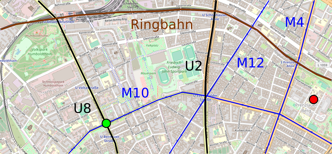
Walking east or west, I exclusively use Bernauer Strasse, the street the M10 tramway runs on; walking north or south, I use Brunnen Strasse, which hosts U8. Other streets can function as shortcuts, but with parks and small changes interrupting the grid, they’re less reliable for through-walking. And indeed, they are much quieter and largely residential, with retail mostly at street corners.
The invention of the stroad
The early American roads connected distinct cities, or linked cities with rural hinterlands. Within the cities, they fed preexisting arterial streets. For the most part these arterial streets were fairly wide – they were mapped in the 19th century based on 19th-century design standards, often 30 meters of width, rather than the narrow medieval streets London is famous for – but they still filled with cars fast. Two parking lanes and four moving lanes in a dense city with busy crossings aren’t much. American cities had traffic jams in the 1920s already.
My two go-to references about the history of American roadbuilding – Owen Gutfreund’s 20th-Century Sprawl, and Earl Swift’s The Big Roads – both explain what happened beginning in the 1920s: cities built bypasses. The idea was that the bypasses would segregate through-traffic from urban traffic, separating roads from streets properly.
This never happened. For the same reason preindustrial roads turned into busy streets, bypasses turned into busy auto-oriented streets. Retailers found that the best place to locate was where all the cars were. These bypasses became congested roads themselves, partly due to the induced auto-oriented development and partly due to general growth in car traffic volumes. This trend intensified after WW2, with the freeways leading another cycle of bypasses around congested urban roads becoming congested with urban traffic themselves. Wal-Mart and Carrefour invented the hypermarket in 1962-3, and in the 1960s office space began suburbanizing as well, since traffic conditions were better than in congested city centers.
This is not an obscure history, and Chuck is fully aware of it: among his complaints about stroads is that they reduce the tax base of the city by encouraging retail to decamp for the suburbs. He just fails to follow this through to the logical conclusion: the most intense demand for real estate is near the busiest through-routes. There is no real separation between the street and the road; the best you can do for walkability is run better public transit to the urban core and make sure the roads have street-facing retail rather than front parking lots.
Strails
The principle that the best place for local traffic is where long-distance traffic is is equally true of trains. An intermediate station on an intercity railway sited a convenient commute away from the city will soon fill with suburban travelers. The term commuter itself derives from the discounted commutation tickets American intercity railroads offered regular riders, starting in New York and Boston in the middle of the 19th century.
19th-century railways were not a complex system of branched lines dedicated to regional traffic. Such lines existed, for example the Ligne de Saint-Germain-en-Laye, now part of the RER A, but most of the lines continued onward to long-distance destinations, or had been built with the intention of continuing so. Look at this map of extant London-area railways by year of construction: there aren’t that many branches predating the Late Victorian era, and the branches that do exist tend to be reverse-branches in South London offering service to either a City station like Cannon Street or Blackfriars or a West End station like Victoria. The remainder are loop lines, built to offer four tracks’ worth of capacity on lines that had originally been built with only two, but then both routes filled with local traffic, making it harder to schedule express trains; for an example easily visible on the map, see the Lea Valley lines connecting to Cheshunt.
In contrast with the London loop lines, Prussian State Railways made sure to rebuild the Ringbahn and Stadtbahn to have adequate capacity, that is four tracks, two for local service and two for longer-distance service; the Ringbahn had initially been built with two tracks, but would be expanded to four in the 1880s and 90s. But even here, there are seams. German Wikipedia explains that the Stadtbahn had to take a less desirable route to avoid expensive takings on Leipziger Strasse, and has a winding route with S-curves between Alexanderplatz and Jannowitz Brücke. Moreover, some individual branches only have two tracks even if they are the best intercity routes: the S2 route is the most direct route to Dresden, but with two tracks, heavy local traffic, and only DC electrification, it cannot host intercity trains, and thus intercity trains to Dresden spend 20 minutes out of a 2-hour trip getting around this line.
Berlin at least has the good fortune that four tracks here are enough. Tokyo is so big and strongly-centered that it has ten tracks going south of Tokyo on the Tokaido Line and eight going north on the Tohoku Line, including four for local service, two for Shinkansen service, and two or four for medium-distance express regional trains. Widening railways to serve city centers is expensive, and only done when absolutely necessary, and yet JR East spent considerable money on widening the innermost Tohoku trunk from six to eight tracks.
Even high-speed rail can induce the same development effect as a freeway. It doesn’t have closely-spaced stations, but people might demand stations as a mitigation of construction impact and train noise. The Tohoku Shinkansen diverges from the Tohoku Main Line a few kilometers north of Tokyo, but the local communities demanded local service as well as a mitigation, and as a result Japan National Railways built a four-track line, with two Shinkansen tracks and two local tracks for the Saikyo Line.
Main streets want to be everything
Major streets are the best location for every destination and every mode of transportation. This extends beyond walking. Buses prefer wide streets optimized for higher traffic speed – and the few main streets that are not so optimized, such as the Manhattan crosstown streets (since traffic is optimized for north-south avenue throughput), have buses that win awards for how slow they are. Bicyclists prefer riding on major streets as well, which is why Copenhagen prioritizes bike infrastructure on major streets rather than on side streets – on side streets car traffic is so light and slow that mixed traffic is not so bad, but the desirable through-routes remain the major streets.
The problem is that every mode of transportation requires some piece of the street, whereas street width is finite. Brunnen Strasse is 40 meters wide, and hosts very wide sidewalks including a dedicated path for on-sidewalk cycling, a combination of parallel and angled parking, two moving lanes in each direction, and a generous road median. Even that width does not include dedicated public transit infrastructure: U8 runs underneath the street, leaving the street’s width for sidewalks and roadways.
The same situation occurs on railroads: all uses want the same piece of infrastructure, leading to the usual problems of mixing trains of different speed classes on the same tracks. Freight bypasses are possible, but passenger bypasses are rare – train passengers tend to want to go to the city rather than to some suburb, and unlike cars, trains have prescribed stop patterns. By rail as by road, bigger infrastructure is needed: four tracks for a mixed local and interregional railway, or about 36-40 meters or even more on a main street.
Wide enough streets don’t exist everywhere. New England streets are narrow. Midwestern streets are wider, but at least the one I’m most familiar with, Ann Arbor’s Washtenaw Avenue, is only around 25 meters wide – it only gets up to 40 if one includes setbacks. Road widening would be needed, which is exactly the opposite of what the Strong Towns approach prescribes. Cities this small could mix decent local and intercity rail service on two tracks with timed overtakes, but that would require them to run any passenger rail service to begin with, and to make sure to have enough development near the stations, both residential and commercial, that people would ride the trains.
But on a 30-meter wide street, something has to give. There simply is not enough room for everything. Give pedestrians their 4 or 5 meters of sidewalk in each direction, cyclists their 2 meters of bike lane, and cars their parking lane and two moving lanes, and you’re already at 30-32 meters. You can go with complete streets and reduce the extent of car infrastructure, for example by turning a moving lane per direction into a bus or tram lane, or by getting rid of street parking, but unless you’re in a city with high transit mode share, you’re driving away eyeballs from retailers. Paris can definitely do it, New York and Berlin can do it, even Boston can do it. Can a small American city where planners aspire to run a handful of buses every 15 minutes do it? Probably not.

One of the arguments tram advocates in Berlin often make is that Berlin has pretty wide roads for a German/European city. No doubt in part due to being barely a fishing village in the 1700s. Indeed some former tram ROWs in old west Berlin still exist as greenspace or extra wide medians. By the way, as you mention the Dresdner Bahn, they’re finally addressing it, in part to better access BER. They ran into problems with NIMBYs in Lichtenrade, one of whom was Klaus Wowereit…
Have you read up on the S-Bahn in the west during partition yet? It’s the turf war to end all turf wars and it explains some otherwise perplexing route choices of the U-Bahn…
The main objection I’ve heard to stroads is not the land use they accompany, it’s that the high vehicle speeds on them lead to an unacceptable rate of road deaths (particularly pedestrians).
Beyond a certain width streets become actively hostile to pedestrians, so there is a tradeoff between pedestrian and motorist eyeballs. In Brooklyn the stroads (4th ave, Flatbush, Atlantic east of Barclays) are not really where the destinations are — beyond a point, very wide streets with fast traffic are unpleasant to walk along (at least for many pedestrians). The best retail streets are 5 Av, Smith, Court, etc. — medium-sized streets that are busy enough to have commercial space but not highway-sized. In Manhattan I am skeptical that Houston is more desirable for retail than say Bleecker. In Cambridge and Somerville the desirable destinations are around squares rather than along the wide section of Mass Ave north of Harvard, or along Somerville Ave. In Champaign-Urbana, the campus town is on Green Street rather than along the arterial (University Ave) and the “walkable downtown” such as it is is not on the arterial either. The things that are on wide roads — gas stations, auto repair shops, KFCs, big box retail — are not exactly places that need to attract eyeballs.
Atlantic east of the LIRR station is less desirable than Fulton, but it’s because of rail service rather than width. New York never modernized its regional rail network, and lacking space for non-mainline urban rail on Atlantic, built an el and then a subway on Fulton.
Atlantic Avenue was the intercity route until the unbuild-able fjords of Connecticut were bridged. The subway replaced the Fulton El which attempted to funnel everything over the Brooklyn Bridge to change trains at Park Row.
Sure, but in between the completion of the NYNHR and the commercial development of Eastern Brooklyn there were like 70 years in which the LIRR tried to reorient itself as a regional railroad; Anonymouse tells me the it invented the commutation ticket in the 1840s.
I think the key difference between a principal avenue or boulevard like those discussed in the article, and a classic, American stroad is that the stroad HEAVILY incorporates highway elements: wide lanes, 60 MPH+ design speeds, clear zones, highway signage, on-site water retention ponds. Sometimes there’s even overpasses, grade separation, jersey barriers. It’s almost always horrendous for pedestrian crossings.
An American stroad is basically building a 6-8 lane highway, which is an enormous public investment, but then since there’s so many accesses & intersections, the average thru speeds are 25 MPH or less. So it functions terribly as a highway.
I’m anti-stroad. I think remedies are: turn them into proper highways & make drivers exit the highway to access commercial. Or turn them into proper boulevards, which means a tighter lane width, street trees, wider sidewalks, etc.
At least in the photo shown on Strong Towns, the arterial is not a freeway. It’s an important distinction because retail wants to be on the arterial but a little bit off of a freeway; the result is that arterials are excellent for transit service even if they’re not particularly walkable, whereas freeway medians are terrible. The average speeds aren’t very high – Washtenaw is 30 mph per Google, so maybe 50 km/h – but that’s net of intersections, which is fine, you don’t need to be averaging 100 going through a city.
I think a lot of the distinction between boulevards and arterials rests on a tourist understanding of European city centers. No shit, Champs-Elysees isn’t a very fast road, it’s literally the Paris CBD. By the same token, the Manhattan avenues aren’t particularly fast and as a result are pretty easy to cross, whereas if you replicate the same design anywhere outside Manhattan, traffic speeds go up and Streetsblog gets cranky. Even in Paris proper the Boulevards des Marechaux are wide and have a lot of space for through-traffic (by car or by tramway), and then there’s stuff like Valhallavägen in Stockholm (and honestly I wouldn’t cross Sveavägen on red even though it’s not as car-heavy as Valhalla).
The one in their banner photo? In terms of the road width, the signage (both from the DOT and the businesses), the setbacks, lack trees or street wall, thick pavement… I would guess that’s almost certainly a highway that’s been infiltrated over the decades with copious commercial accesses & signalized intersections. As you indicate, these things did naturally evolved in many places. Older suburbia, etc. I actually think that version is fairly innocuous.
One thing that started happening nationwide in 1980s is that small metros across continent as well as major city exurbs, starting going out & building these environments from scratch for explicit purpose of attracting Walmart, et. al. So there’s just a big, very expensive road, that doesn’t really connect to anything, that’s lined with box shopping & used car dealerships by design.
Here’s an example. It’s basically a highway, it doesn’t go between anything. It doesn’t even connect to the interstate. It’s was built through what were cornfields on the outskirts of a small metro, with really the only purpose being to circulate vehicles between discount shopping destinations. It’s basically a $100M public investment to facilitate an auto-oriented commercial area that obliterated local business within a 10 mile radius. And some places continue to build stuff like this…
https://www.google.com/maps/@41.706197,-86.1874552,3a,75y,178.95h,90.05t/data=!3m6!1e1!3m4!1sJng3xTJxlCIiCLFhR08Gjg!2e0!7i13312!8i6656
This feels less like an arterial and more like a highway that the municipality desperately wants to turn into an arterial. It’s reminiscent of various boulevards built by Belle Epoque autocrats hoping that if they planted some trees they’d get Champs-Elysees; the widest street in Jaffa, Jerusalem Boulevard, is one example, and more than a century later it’s still less commercially important than the older Yefet Street.
In contrast, in the same region you’ve linked to, look at US 20-Business. Its western half looks somewhat older (two-story buildings without setbacks) than the eastern half, but both are your basic arterials in a city where everyone who isn’t on food stamps is expected to own and use a car. The name of the road is suggestive of its origin as an intercity highway that filled in with auto-oriented retail. Ditto US 31-Business. The bypass that carries the current US 20 and 31 is less like this – it’s a full freeway, so no continuous retail.
The street was there before there were automobiles.
I’d consider US-20 & 31 to be a completely different beast than the other example. Both those routes probably hosted quality transit thru WW2, and since then have become auto-oriented arterials, lined with the auto-oriented stuff. At some point in the future, they *could* become transit oriented again, and be lined with transit-oriented stuff, because they still hold transportation value. They go into the downtown & airport, where there’s coach bus & train connections to Chicago, Cleveland & Detroit, etc. The other road – Grape Road – only really exists to support shopping. These things are everywhere.
My metro has a 50 mile(!) mega-stroad that goes all the way around it. Wis HYW-100. It starts about 15 miles south of Milwaukee & runs a huge circumference. It serves little-to-no actual transportation purpose, since it’s redundant of limited access interstates. The bedroom communities it passes through have little to no “mass” to them (and no interest in developing it…). The stroad serves to circulate cars between an enormous series of big box stores. But the state recently spent $1.7B on a mega-highway interchange that it was part of, the road itself is probably $15-20M/mile before interchanges, off-passes, traffic signals… It’s an enormous investment in discount shopping.
https://www.google.com/maps/@43.1776595,-88.0179907,3a,75y,294.08h,84.66t/data=!3m6!1e1!3m4!1sR8zrmaV2N1q6TQ4COefoKg!2e0!7i13312!8i6656
IMO – 1) we have to stop building these. When we don’t have the funds/political will to maintain what have, does getting that 6th superstore within a 15 minute drive do anything? 2) for the US-20s, we need to go back & overlay zoning that at least allows traditional building types, relax off-street parking requirements, etc & hopefully these evolve into viable transit & pedestrian oriented arterials again. 3) for the HYW-100s & grape roads, I’m not sure what they future will be… If there’s a way to get more transportation value out of them, I’d pursue it. I’d rather we close a couple commercial accesses on HYW-100 to speed it up, than spend a billion adding a 20 lane miles to the interstate, etc.
I think Chuck is referring pretty exclusively to the phenomenon of the American suburban stroad as opposed to an urban boulevard. People aren’t going from 60 + MPH to a dead stop in London boulevards, but they do so routinely on stroads in suburban New Jersey, Texas or California. This is a phenomenon where all of the retail in an area is along what is essentially a highway, with huge parking lots right up against that highway, usually with physical barriers in the middle of the highway to prevent pedestrian crossing at all but the few scattered intersections, which are sometimes hundreds of yards apart.
Outside of these stroads, there is no town. No main street. Just residential. That’s the majority of America’s suburban landscape.
That’s a completely different animal to your typical urban boulevard, which may be wide, have many forms of transportation along it, and may have pedestrian-oriented destinations. Sure, urban boulevards might be difficult to cross and are not as pleasant for pedestrians as your typical urban streets, but they are not even close to the same category as a stroad.
Well, yes, the arterial is the main street, you don’t need commercial development on side streets.
They did do 60mph to a dead stop on the A40/A4/A406 until they put average speed cameras on those roads.
That’s in London.
I do wonder if there are changes in technology that could affect the relative importance of through traffic and local traffic in location selection for retail. When your main form of advertising is being seen by someone passing by, it’s valuable to be located where lots of people are passing by. But we saw with taxis over the past decade that there are now more effective ways to match riders with taxis than to see each other while passing by – a GPS-enabled phone on each allows them to find each other even if the taxi is waiting on a side street and the passenger is just stepping out of a residence on a different side street. If the city imposes significant costs on any business that chooses to locate along a through-route (say, a large fee for any driveway access to highway frontage roads), and if customers and businesses can get better ways to find each other than mere eyeball visibility on the through-route, then perhaps it is possible to reach some sort of equilibrium where most businesses choose to locate on a local route and through-passengers are located on a parallel route (with sufficient information that they can get off at a local exit/stop if they hear about something on the main street that they want to visit).
Not that I know of any place where this has been achieved, or that I know how any of this translates to the through-route and local-route versions of transit and cycleways.
I don’t know that this is relevant to your rail point but I agree with Strong Towns that trying to accomodate vehicular through-traffic, parking and pedestrians in a single corridor leads to problems.
– if the road bit is bordered by parking, with sidewalks on the other side of the parking, it makes a lousy road for through traffic (since vehicles need to be going slowly enough to react to cars suddenly pulling in or out from the parking spots, which reduces road speed and capacity especially when most people want to travel)
– if the road bit is bordered by sidewalks, with parking on the other side of the sidewalks, it makes a lousy sidewalk (since pedestrians are separated by parking from their destinations, they are close to fast and noisy traffic and their route is cut by driveways which can function like highway on-ramps and off-ramps if through-traffic is moving fast enough).
An alternative is to think of the road and two sidewalks as separate things, and then lay them out that way. If you place some of the parking and destinations between the road and the “sidewalks” (or rather narrow shared streets), facing the streets rather than the roads, this wall of destinations separates pedestrians from vehicular through-traffic, improving vehicular speed and pedestrian comfort and safety. Local merchants could have signs on the road sides of their properties to attract driver or passenger eyes but the entrance would be on the street side.
So I agree that, for the reasons you give, you want to have through traffic and local traffic as close together as you can (and that might be directly adjacent for rail) but I think you need something to separate a road and a street for them to work optimally.
I agree with most of the others that Chuck is not talking about urban boulevards, especially not when they’re done as well as in Paris. The stroad is a mostly American suburban construct, though that hasn’t stopped overzealous DoT’s from trying to ram them through town centers either. This is a great example of one in what is likely a fairly dowdy little town that’s been pretty thoroughly reamed out: https://cdn.citylab.com/media/img/citylab/2014/01/07/screen_shot_2014_01_07_at_14622_pm/facebook.png?1494542495 and the associated video: https://www.youtube.com/watch?v=F6jFnOnjzrk
I think the most important thing is that the stroad is trying to be both a road/highway (moving a lot of motor vehicle traffic quickly and little else) and a street (which Chuck calls a platform for development, i.e. the organizing structure for developable land around it and a place where things other than just vehicles moving and parking happen like pedestrian and bike access, a route for utilities, mail delivery, parades and festivals, trees, water, etc.) and critically, that it does *neither of them well.* Roads/highways are for mobility and streets are for access, but again, the stroad does both poorly. They have 50+ mph design speeds, and they’re usually signed for 35 mph, so traffic speeds are routinely 40+ mph which is anathema to pedestrian activity. Nonetheless, with all the driveways and cross streets and signals, total speed is lousy so they’re bad at moving traffic as well.
The Champs-Élysées is more like a road with two streets flanking it. Granted it’s still something of a sub-standard road and a sub-standard street, at least when it comes to crossing it, but walking along it is great in comparison to the American 7-laner. It actually attracts development, whereas the stroad repels it, and I would argue that it is both a better road and a better street than the typical American stroad.
Does the stroad really repel development? The example in the image you link to looks very well-developed. The street looks around 35 meters wide and has zero-setback retail. The lanes are wider than I’d like but otherwise it’s not bad.
Champs-Elysees attracts development not because it’s somehow pleasant (it really isn’t) but because of the usual sequences of how CBDs migrate: wealthy residents attract high-end retail, which then attracts high-end offices. It’s the same with the West End of London, 5th Avenue in Manhattan, and more recently American edge cities that formed in or near the favored quarter, like Tysons, Stamford, White Plains, and Century City. Here, too, during the Cold War the historic CBD was in the East, so the West had to develop a new CBD and picked an already rich location in Kurfürstendamm. Good locations for such development, besides being already rich, are major arterial streets like 5th Avenue or Oxford Street, or notable road crossings like Tysons; I imagine Stamford and White Plains benefit from having already had nonstop trains to Manhattan.
The arterial is a compromise between access and through-speed, but that compromise is common in public transit as well. When you build a public transit line at any scale from local bus to high-speed rail, you have to choose the stop spacing, and the optimum will always be a compromise between speed and access time.
Yes, it really does. It may not lead to vacant lots, but it pushes the buildings away to hide behind parking lots since a door opening onto a narrow sidewalk with fast moving traffic sucks, and parking to the side is so uncouth. Even the use of concrete makes it louder. These buildings in the photo obviously predate the reconstruction of this street (it’s not even finished with construction), but the telephoto zoom makes it much harder to see all the empty space, and there’s a lot of it which is pointed out in the video.
I don’t think Stamford is a good example. Downtown Stamford was a slum in the 1960s; the office towers and mall there were built in a master-planned urban renewal project for which most of the old downtown was razed. Even today, the residential areas around downtown and the train station are working-class Hispanic neighborhoods; rich people live further north, along the waterfront, or in neighboring towns. Downtown Greenwich would have probably become the major edge city instead had Stamford urban renewal not scared nearby towns into hard-line anti-development attitudes (understandably so: the Stamford CBD is almost surreally hideous, and the few modernist office buildings around the Greenwich train station aren’t much better). Even today, judging from listings on Cityfeet, downtown Greenwich has considerably higher office rents than downtown Stamford: respectively about $70 per year per square foot for class A space and $45 for class B, versus $35 and $25.
A glance at Wikipedia and a few other old articles suggest that your chronology works for White Plains, though. I can’t speak to the other examples.
Ugh, this was meant to be a reply to Alon in the comment chain above.
In non Anglophone grid cities the intersections with the low numbers are usually pedestrianized and also the main center of business.
The German term “Fußgängerzone“ evokes a sense of main shopping area downtown and to some extent venue of political debate and protest in the average German. It is usually within walking range of the main train station and the historic old town our partially identical with the latter
Another example: the forum romanum was free of through traffic during ancient times and the center of commerce and politics. I think the center of Periclean Athens was the same
Can you do a post on the contradictory demands for the site of the main intercity bus station?
On the one hand, it is desirable that it is within easy reach from the highway. On the other hand it should be as close to downtown as possible and also easily reachable by public transit. And last but not least there should of possible be one interchange station for every city for connecting passengers.
It’s almost impossible to find a site that goes all requirements. Berlin ZOB certainly doesn’t…
Boston’s bus terminal manages to meet almost all of these requirements by being located above the South Station platforms and having easy access to both I-93 and I-90. The main issue it faces is having no direct connection to the routes that end at North Station and being limited in capacity because of its location. The final expansion to the current bus terminal is set to start as part of the building of the South Station Tower this spring which will double the number of berths for buses; however, after that the terminal will be out of space to expand. I find this bus station to be an interesting case study because it is in many ways a best case scenario outcome of the competing demands while only being possible because of the unique history Boston has as a result of building highways through the downtown.
Yeah, Gallieni in Paris doesn’t either – it’s very convenient to get to by highway, but it’s at the end of one Metro line with no RER connection in sight. In London I think they go the other way and have urban bus stations at places like Victoria and Aldgate, with great Tube connections and horrific highway connections.
What about central bus stations in Israel?