The Boundary Between the Transit City and Auto-Oriented Suburbia
Public transportation use is higher in cities than in suburbs. Cities with stronger transit networks have larger transit-rich, auto-hostile cores, and some have good transit in lower-density suburbs, but ultimately the transit city has a limited radius, beyond which automobiles dominate. Successful examples of suburban transit, like Zurich, just keep the city-suburb gradient shallower than in other transit cities.
The most fascinating aspect of this is the boundary between the transit-oriented city and the auto-oriented suburbs. Uniquely in the metro area, the boundary region has good access by car as well as by transit, making it ideal for uses that want to interface with both modes of transportation. This specifically includes bus stations, stadiums, and big box retail, as well as more sporadic meeting points between urban and suburban residents.
Where the boundary is
Because the boundary zone is defined by good transit as well as highway access, it may not be the literal boundary as defined by modal split, car ownership, or any other metric of transportation usage. It can be the outer end of some rail line extending into the suburbs, and in that case it may be a salient into auto-oriented territory. There are a number of examples in the United States, where the postwar rapid transit projects have not been accompanied by much transit-oriented development, and thus their outer stations are in low-density suburbs where transit service functions as expensive S-Bahns. BART and most of the Washington Metro are like this, as are the suburban lines of the Boston subway.
For example, here is Newton Centre, on the Green Line D branch:
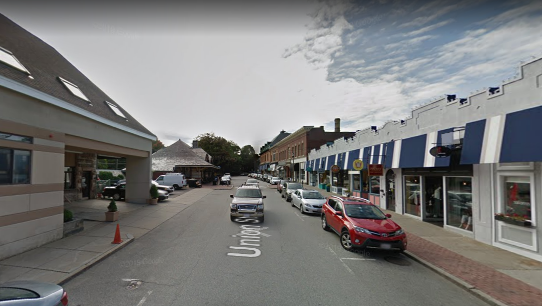
The light rail station is just to the left (south) of the street. This is a walkable suburban street with a train that comes pretty frequently all day, and yet the dominant mode of transportation here is clearly cars, as one can see in the parking lot to the left. Transit usage here is similar to the metro area’s average – Newton averages 11.9%, the Boston metro area 13.4% – but this says more about the rest of metro Boston than about Newton Centre. Nonetheless, such a location is convenient to access from the city if one lives near the Green Line, and is also reasonable convenient by car, as it is just 4 km from the freeway, and the majority of the distance is along the fast arterial that is Route 9.
The importance of highway access also works in reverse. In cities with strong transit networks and weak motorway network, there may be a freeway salient into the city, creating a zone that is car-friendlier than the rest. If it also has ample parking, which it usually does, then it will end up creating a boundary within an area that is on most metrics transit-oriented.
In London, the urban renewal zones around Stratford and Canary Wharf are examples – the city is unusually poor in freeway infrastructure, but two of the few radial motorways hit these two business districts. Here is Stratford:

The built-up density is high, and Stratford is one of the busiest Underground stations. But the roads are big for the city they’re in and there are large surface parking lots all over.
I’m deliberately including two examples with very different urban layouts and actual transit usage levels to hammer home the point that the boundary is defined merely by the existence of supportive infrastructure for both cars and public transit.
Can the entire city be friendly to both cars and public transit?
No.
There are several reasons for this. The first and most fundamental is that public transit is only successful if it can leverage scale. The adage frequency is freedom comes from this fact, but the same can be said about related issues of span, reach, and network effects. This is why frequency-ridership spirals are so dangerous – a small cut in service can lead to a much greater reduction in ridership.
The second reason is that drivers prefer a different urban layout from transit users, cyclists, and pedestrians. Cars are space-intensive on the road as well as on the parking lot, but can achieve high average speed if there’s no traffic, so they end up preferring spread-out development. Public and active transport are space-efficient but involve a lot of slow walking, so they prefer dense development at distinguished nodes with train stations, featuring strong commercial city centers with high job concentration. The boundary zone I speak of must be underlain by a strong enough transit network in the city core that people will fill the trains at all hours of day.
Concretely, neither the example of Newton nor that of Stratford can work citywide. Newton cannot work citywide because if every residential metro station is a parking lot, then nobody will ride the trains off-peak, and the city will de facto be exclusively auto-oriented as a result. Two years ago I compared the proportion of boardings at suburban stations that occur in the morning peak in New York (67% LIRR, 69% Metro-North) and Paris (46% on the SNCF network). Well, I would later find data for the Washington Metro, which has high off-peak frequency like the RER but low-density parking lot stations like the LIRR and Metro-North, and the proportion of riders in the morning peak is much closer to that of the LIRR than to that of the RER.
Likewise, Stratford can’t work citywide, because most of the city is not a reclaimed railyard with enormous space for all manners of new development. Building the expansive motorway network that would allow cars to rapidly reach every part of the city would normally require extensive neighborhood demolitions; American cities only managed to do so because to the road builders, destroying working-class (and often black) neighborhoods was a feature rather than a bug. Building a new city with ample road infrastructure is possible without this history, but then one gets Houston, hardly an example of good transit accessibility.
Land use at the boundary
The boundary zone’s unique accessibility by both cars and transit makes it ideally suited for land use that really wants both. Such land use has to have the following features:
- It needs to have a large regional draw, or else distinct neighborhood centers, some transit-oriented and some car-oriented, can do better.
- It needs to specifically benefit from good highway access, for example for deliveries, but also from good transit access.
- It is not so high-value that city center’s better transit access in multiple directions trumps access by transit in one direction and by cars in another.
Sporadic meetings satisfy all three criteria. For one personal example, in 2013 I visited New York and participated in a LARP taking place in a camp somewhere in Massachusetts, accessible only by car; I traveled with friends in the suburbs and we arranged that they would pick me up at Southeast, the northern end of the Metro-North Harlem Line’s electrification, so chosen because of its excellent multidirectional freeway access.
I bring up LARPing because it’s such a small community that it has to draw regionwide – in the case of the one I went to, participants came from all over Eastern New England and even beyond – and thus, anywhere with lower transit usage than New York, must appeal primarily to the driver, not the transit user. Nerdy conventions in general tend to either be enormous, like Comic-Con, or take place in cheap suburban edge city hotels, with meetings for carpools arranged at choice suburban train stations.
More common uses that like the boundary zones include major stadiums and big box retail. Stadiums appeal to a broad section of the population with little differentiation between city residents and suburbanites. They have to have good transit access even in auto-oriented American cities for reasons of capacity, but they also have to have good auto access for the use of drivers; stadiums are land-intensive enough that they can’t locate in city center at all, with its omnidirectional transit access, so instead they must be at the boundary zone. Thus Stratford hosts the London Stadium, the Stade de France is in Saint-Denis with good motorway as well as RER access, and Yankee Stadium is tucked at a corner of the Bronx with two subway lines and good expressway infrastructure.
Big box retail is more complicated – for one, its draw is so local that even a small city can support several Walmarts, Carrefours, and Aldis (Walmart is weak in big cities, but the big European retailers aren’t). Nonetheless, boundary zone stores exist: the big supermarket I’m most familiar with in Boston, Star Market at Porter, is on top of a subway station but also has a large parking lot, while the supermarket I shop at here in Berlin, Kaufland, is a two-story big box next to the Gesundbrunnen U- and S-Bahn station, with the ground floor devoted to parking.
I suspect the reason big box retail likes the boundary zone is that while it is local, there are extensive mixed areas rich in both drivers and non-drivers, where a big store must appeal to both in order to succeed. The Gesundbrunnen area is one of the city’s densest, but car ownership in Berlin is still higher than in Paris or New York. The same is true of the area around Porter Square in Cambridge and Somerville, albeit at lower density and with lower transit usage, so Star Market puts its parking on the surface rather than in a structure.
Bus station siting
The most interesting land use that prefers the boundary zone, and the origin of this post, is the intercity bus station. Here is Herbert in comments:
Can you do a post on the contradictory demands for the site of the main intercity bus station?
On the one hand, it is desirable that it is within easy reach from the highway. On the other hand it should be as close to downtown as possible and also easily reachable by public transit. And last but not least there should of possible be one interchange station for every city for connecting passengers.
It’s almost impossible to find a site that goes all requirements. Berlin ZOB certainly doesn’t…
Whereas train stations have obvious preferred sites – the central business district – bus stations have to balance centrality with highway access. In Paris, this is Gallieni. This station is just outside the city at the end of Metro Line 3, where the Boulevard Peripherique meets the A3 autoroute, which connects to further motorways with good access to the north, south, and east. Like Stade de France, Gallieni is a salient of the auto-oriented suburbs almost into city limits, in inner suburbs with high public transit usage.
In New York, there are a few sites that would work fine, but each points in a different direction, making interchange difficult. Port Authority is excellent for buses going to New Jersey and points west and south, and curbside buses tend to pick up in that general area as well, often near Hudson Yards; this is facilitated by a unique situation in which the Lincoln Tunnel has a dedicated inbound bus lane in the morning peak, which many area transit activists wish existed in both directions all day. Buses to Boston could depart from Yankee Stadium, which also benefits from being just beyond the outer end of subway express service, so that travel speeds to Manhattan are faster. However, in practice they depart from the same curbside location on the Far West Side as the buses to Philadelphia and Washington, frustrating riders who see their bus spend an hour in city traffic.
The situation of New York is unusual in that it is located next to two wide rivers with few crossings, and thus does not have a proper orbital motorway with a location like Gallieni. But New York is not unique in having difficult bus station siting choices. London has the same problem: for one, the M25 orbital is so far out of the city; and perhaps more importantly, British buses are priced cheaper than trains in order to control crowding levels on trains to London, and thus dumping bus passengers on a regional train to Central London would be strictly worse than just letting them ride the train the entire way for a reasonable fare.

The situation of New York is unusual in that it is located next to two wide rivers with few crossings, and thus does not have a proper orbital motorway with a location like Gallieni.
NYC has a beltway around the city, but I-287 simply doesn’t occupy the public’s mental references in the same way that the Beltway in DC or the M25 does in the UK. Conceptually, Gallieni seems closest to the GWB bus terminal, but everybody seems to hate that location because of the reputation of the neighbourhood, and the fact that it’s so far from Midtown.
Parenthetically, A10, Berlin’s “capital beltway” which was largely finished during partition (the Nazis had started building a bit but there route choice was different) is even longer than London’s orbital motorway and even farther out. I don’t think anybody would consider a bus station out there a good idea, even if there were a good intersection with the S-Bahn.
for one thing a bus that goes east-west through Berlin would have to detour a lot on a busy highway (all circular highways tend to be extra busy) if the station is in the south and the same would apply with a station in the east for a north-south bus. And it’s not desirable for riders to have to Nick about with multiple stations when changing buses.
I-287 is significantly further away from the center of NYC than the other example are from their cities. I-287 is 22-24 miles from Midtown for most of its length, and the junction with I-78 is more than 35 miles away. It swings so widely around the city that no one would reasonably drive its full length for a single trip – there are always shorter routes that still don’t go through the city.
By comparison, the DC Beltway is ~8-11 miles from the city center, the M25 is 12-25 miles from the London CBD, and the Périph’ is only ~3-4 miles from the center of Paris.
I agree that in practice NYC does have highways that meet the “beltway” demand for circumferential travel, but which road you would specifically use depends on which side of the city you’re on: the turnpike (I-95) or Garden State Parkway in Jersey, the Cross-Bronx Expressway (I-95) north of the city, I-678 or the Cross-Island Parkway in Queens/Long Island, and the Belt Parkway + I-278 in Brooklyn & Staten Island. That gives you a loop with a radius of ~7-13 miles, roughly comparable to DC.
Westminster council in London has been incredibly hostile to Victoria coach, due to all the smelly buses clogging up some rather high priced residential streets. They’ve long pushed for suburban park and ride coach stations, which could make for overall faster journey times yo Central London. The problem is that a large percentage of people are interchanging between coaches at Victoria, plus a lot of people have a lot of heavy luggage, changing onto nearly always crammed trains or tubes at extra cost in money, time and hassle will do nothing for the convenience for passengers. So the bus industry certainly does not want it.
The only hope in mooted mega redevelopment of Victoria station where over rafting could conclude a modern and better located coach station.
What I don’t get it, how much all these schemes cost and how much it would cost to add rail capacity by four-tracking various two-track narrows (like on the ECML?) and lengthening platforms. Or just building HS2, but somehow the budget for that keeps expanding from year to year for reasons I don’t really understand.
The East coast mainline main choke point is the two track viaduct above a deep valley hemmed in by suburban towns to the North of London. The are a variety of schemes to remove flat junctions and add more platforms at certain stations, But the Network Rails preferred scheme was a high speed bypass line costing several billion.
Hs2 would remove the express trains to Leeds and Edinburgh, thereby removing a need for this option for several decades.
The reports of escalating costs on Hs2 are often published by anti large infrastructure/public spending groups. Or even groups who don’t want anymore money spent near London. I’ve seen reports that load on additional road and local transport schemes that should be built to maximise the benefit of Hs2.
I really don’t believe any forced mode-change somewhere in the boondocks could possibly lead to faster journey times. Not to mention the cost as all transport in London is excessively expensive. I used coaches into Victoria from both the south (Brighton) and NW (Oxford) and they were surprisingly efficient. I suppose I mostly avoided peak-hours but it is surprising how smoothly those big coaches glide around inner-London. The station is a very good location, as well of course being part of Victoria mainline station and for the Victoria, District & Circle Underground lines. Also it is actually within walking distance to many places. While I found lots to complain about the LU and most things in London, this is a rare thing I thought was quite good. But not if I was dumped in the wilds of outer London, wait around for a train, pay another £5 to £10 for an interminable journey into London (Underground trips from the outer suburbs are always interminable)–especially if it was due to undue influence by a bunch of rich toffs in Kensington!
OTOH, I suppose if I lived in that ritzy area (QEII is practically a neighbour of the station; Julian Assange must be just down the road in his embassy lair, in Kensington) I might be selfish and complain too, though I wonder how much difference it makes in that extremely busy area. Everywhere in central London is overrun with local buses.
Having said all that, I suppose I am a prime hypocrite because, as a Paris resident, I was grateful the main intercity bus terminal in Paris is out at Gallieni, ie. out of central Paris. Indeed I object(ed) to those big tourist coaches that thunder around Paris delivering millions of Japanese tourists (well today I suppose it is a lot more mixed; back then there was a joke re Notre Dame, that if the towers fell down on the front pavé it would be a Japanese national disaster); there’s a coach carpark at the back of Notre Dame which shouldn’t be there. But a difference with Paris is that Gallieni is not far from central Paris and the Metro is both very efficient and cheap and flat-fare. Though I seem to recall the few times I caught the London-Paris bus that it arrived at Gare du Nord which is kind of the same situation as Victoria.
An interesting example is Schkeuditz west S-Bahn stop between Halle and Leipzig.
I guess its purpose is to serve workers at one of the airport adjacent businesses nearby (LEJ has the second highest cargo traffic in Germany after FRA) like Amazon or DHL. But it serves another purpose these days as it is minutes off two major highways and the last station within Saxony. The couple of ten thousand students that study in Dresden can travel on local trains throughout Saxony for free, so it’s the ideal dropoff point for shared rides.
Cars are space-intensive on the road as well as on the parking lot, but can achieve high average speed if there’s no traffic, so they end up preferring spread-out development.
That’s what happens when you have 2 acre zoning or even half acre zoning. Almost everybody has to drive the main road and even the people who wouldn’t have to drive to the main road, have to drive once they get there. They then all want to park right in front of the door of their destination. … from where I parked my car to the back of the big box store is a longer walk than through the center of the bigger trolley suburbs I’ve lived in. But that’s ‘too much walking”
Wow. Without mentioning Philadelphia by name and (I’m pretty sure) your having done a tour of our city-suburb boundary, you have described Philly exactly (except for the intercity bus station, which is downtown). Stadiums, shopping centers, big box stores are all located at boundary stations and transit centers.
Question: is there a situation where a suburbanish park-and-ride station makes more sense than one within a TOD satellite town with little parking? We have tons of the PnRs here; I don’t know how to think about this exactly.
correction: “your never having done…”
I honestly did not know this was true of Philadelphia specifically, even though I used to spend a fair amount of time around Jenkintown (SEPTA was the first commuter rail system I ever took)!
Park-and-rides make sense for specific boundary stations. I can’t give you good examples in Philadelphia because I don’t know it so well, but around New York, good examples include North White Plains, at the northern end of Harlem Line local service; Southeast, at the northern end of the Harlem Line save for a handful of daily diesels; and Jersey Avenue, at the southern end of NEC local service. Ronkonkoma, at the eastern end of the LIRR Main Line save for a few diesels, may also qualify, but I don’t know it well, I’ve literally never been to Long Island. The implication here is that park-and-rides are overused elsewhere – for example, I’d redevelop both Metropark and Princeton Junction, Metropark because it’s in the largest suburban job cluster in the region (possibly in the country, possibly in the world) and Princeton Junction because it is a railroad junction and so should get more rail-oriented development.
The common feature to North White Plains and Jersey Avenue is that both are right behind a major walkable town center with high ridership, so including them expands the reach of commuter rail without requiring too much strictly one-way peak service. Then Southeast is at the intersection of several freeways – like Ronkonkoma, it only got electrification in the 1980s, so the location was chosen deliberately to maximize access by car. North White Plains is close to I-287 as well, though Jersey Avenue isn’t really close to any highway – US 1 intersects the NEC 3 km to the south. Are there similar examples in Philadelphia?
Of note, there’s no equivalent of Jersey Avenue on the New Haven Line. I suspect this is the result of a peculiar socioeconomic pattern: the two municipalities behind Stamford, Darien on the main NEC and New Canaan on the branch, are the two wealthiest in the state, so they effectively hog the resource that is “auto-oriented station with express service to Manhattan.” There may also be a population density artifact: people in Fairfield County mostly live in the coastal municipalities, so they can just take the train at their local station, whereas Westchester and Central Jersey have less linear population distributions.
…I might expand this to a full post, actually.
In Berlin there’s a complaint that city boundary park and ride stations are overburdened because people who can wish to avoid paying ABC tickets instead of AB. The only way to fix that would be to charge more for parking…
The next stop further out on the NEC line, Hamilton, is more PnR than even Jersey Ave and also has easy car access to I-295. When I lived in South Jersey, I used this for occasional day trips to NYC. Checking the license plates of parked cars, one also see lots of Pennsylvanians from Bucks County. Humongous parking lot (both surface and multi-story), at $7 a pop, fills up nearly every day. One stop (Princeton Junction, another PnR) ride to Newark, then NY Penn. So, I’m guessing, this is the picture-perfect setting for a park’n’ride.
In Philly, I’m seeing possible park’n’rides for Upper Belmont Ave, just off I-76, being an extension to the otherwise nearly useless Cynwyd line and adding parking to Eastwick, convenient from the south on I-95. In both case, not suitable for TOD. But I’m sure there is more complex/rigorous analysis to do.
Eastwick is already effectively a park-n-ride if you feel comfortable crossing Bartram Ave; check out the gigantic parking lot across the street. I’m sure most people don’t use it because Bartram Ave is not pedestrian friendly, so a little crosswalk would go a long way.
When you say Upper Belmont Ave., do you mean historic Barmouth station or roughly Belmont & Jefferson Ave? The former is in a dense, transit-oriented location, that constrain parking space. The latter is a bit hard for cars to access, because it is high above the roadway (although in either case, the Cynwyd heritage trail is mostly removed, so maybe an access drive along the current route would suffice)
The latter. I’d build a ~5-story carpark where that Sunoco station is (between Belmont and Old Belmont). The station platform would be above and across the street, where the heritage trail is and connected to top floor of the carpark via a pedestrian bridge.
Barmouth is optional. They closed that historic station for a reason (located in a cemetery!), so I guess people weren’t dying to go there.
Elwyn! Immediately behind Media, a major walkable town center, and offering relatively good access to Rtes. 352 and 1. When it was built, Claymont probably counted. It is still adjacent to I-95, but Marcus Hook has decayed too much to be considered a major town center.
<a href="https://en.wikipedia.org/wiki/Fort_Washington_station" might count, because it follows Oreland and is is just down the road from an I-276 offramp. But the schedule pattern doesn’t really fit: between Center City and Lansdale, most trains either make all stops, or run express between Center City and Ft. Washington.
In fact, I think Ft. Washington suggests a more interesting phenomenon: when a park-n-ride “bridges” a gap between walkable town centers. For example, Ft. Washington follows Oreland, but it also precedes Ambler. Similarly Miquon “bridges” the gap between Manayunk and Conschohocken. Of course, Miquon has terrible road access, so it may make more sense to build TOD around it instead. (I’d like to cite Winfield on the UP/W line as another example, but Metra puts parking lots by most stations, so it’s hard to tell what’s park-n-ride.)
…I might expand this to a full post, actually.
Rummage around for the grumblings about all the parking. People in Ronkonkoma, West Windsor ( Princeton Junction ) and Hamilton are getting grumpy about the parking and the traffic it creates. As ckrueger99 pointed out Pennsylvanians drive to New Jersey so they can go to New York. The tracks pass through Pennsylvania, they could be getting on a train in Pennsylvania. People drive from much farther out in Suffolk County to get to Ronkonkoma. They could be driving to park-n-ride a bit farther east with dedicated ramps to the Long Island Expressway. They wouldn’t be clogging traffic in downtown Ronkonkoma such as it is. Someday the end of local service through New Brunswick will be one stop further out at a new station in North Brunswick. Jersey Ave can remain the park-n-ride for suburban New Brunswick which keeps those cars out of New Brunswick and North Brunswick. ….It’s okay if the suburban line has “downtown” stations and park-n-rides where the highway crosses the tracks.
….south of Matawan/east of Hazlet, should be thought about. Let them get on a train where the tracks cross the Garden State Parkway instead of Matawan or Metropark People in Matawan aren’t thrilled with the parking or traffic either.
There are other solutions besides parking. In anticipation of Midtown Direct the state offered to build garages. Summit decided to decline the offer and built their own garage, it can be offered to Summit residents first. Maplewood decided they didn’t want a garage and came up with a parking plan and jitney bus system. Other stations have jitneys now too.
Yes, nobody likes traffic. But there is certainly no station at Hamilton without it. This is a very successful station in terms of number of riders, so much so that Princeton area residents sometimes drive there instead for a better chance of getting a seat on the train. Don’t get me wrong; I hate that place (and the whole concept of park and rides).
To beat a dead horse one more time, if ARC was opening on schedule there could be more trains and they’d get a seat in Princeton Junction. Park-n-rides have the virtue of putting the parking and traffic outside of downtown. If Hamilton wasn’t there, they would be screaming to build garages in Trenton and West Windsor.
“British buses are priced cheaper than trains in order to control crowding levels on trains to London”
I thought that was because privatization allowed the train companies to set arbitrarily high prices?
The buses can set high fares too, no? But anyway, the trains could lower fares if they had more capacity, they just don’t have extra capacity as the network is currently built, and British construction costs don’t make it easy to add more.
Alon, I think you know the answer to that. The trains were privatised as a monopoly, ie. by route and region (eg. all of Southern) while buses became a free-for-all. It being relatively cheap to set up a bus service, it is true that the competition, at least at the beginning, was fierce and so prices were low. However it produced quite a mess, both on the roads (all those narrow roads in small towns that weren’t so small anymore: bus congestion) and commercially as they fought it out, with bankruptcies and mergers etc. Apparently it has just got worse and it is another industry on Corbyn’s re-nationalisation hit list. Like with trains he’s probably onto a winning policy.
Re capacity of Brit trains, was it on PedObs that some commentator claimed, despite their loading gauge, there were attempts underway to design a duplex train?
There were indeed attempts at duplex trains, but they were abandoned because the loading gauge was too small. They couldn’t even have two full decks, they had weird shit like making you insert your feet into a sunken bucket on the upper level that would then visibly protrude out of the lower level’s ceiling.
That said, German intercity trains are single-level and so are Swedish ones.
Germany, not to mention Stockholm, doesn’t have a city even half the size of London. Nor the tradition of so much long-distance train commuting into the capital. Of course they could run more trains to cope but Southern actually reduced their service frequency to cope better with whatever limitations those routes have (signalling? too much branching?).
The contempt the UK ruling class has for everyone else is something to behold. And the cost of all these things–long distance trains, the Underground, now apparently the buses … As Gary Younge wrote yesterday, Brexit is not the cause of political breakdown but merely the symptom. I’ve been saying it for 30 years. Though Corbyn is not the solution, this is the reason for why significant numbers back him. Alas, the same victims of that and other shit, are the same ones who blame it all on the EU and immigrants etc and support Brexit.
First fares and service levels on British Rail is highly regulated. The private train operators are just service contractors running contracted services, As passenger numbers have doubled since privatisation of Rail there is not much scope for additional services on top of the contracted ones.
Since privatisation, central government control of fares and service levels has increased. A lot of the problems experienced in recent years has been due to the service levels and (ahem) planning skills of the people at the DFT.
The new ICs are double decker. But they’re limited to 160 km/h and have been derided as “white painted regional trains”
When British rail fares are five times higher than in Europe, it’s difficult to understand how this could be due just to a lack of planning skills at the DfT.
I think that’s mostly about rail commuters, not intercity travelers? So then you get the intersection of,
– Lower British wages than in the functional parts of the Continent,
– A completely dysfunctional mainline rail network outside London, on a par with provincial France or even worse,
– High London fares, set at breakeven rates rather than the more globally typical subsidized rates, and
– Probably longer-range rail commuting in London than in peer cities, since the only European city of the same size class, Paris, is much denser.
I’m willing to believe the average British rail rider pays 13% of the average British salary, but the person earning the average British salary doesn’t ride trains unless they happen to live in a really poor part of South London (in other low-income London neighborhoods people ride the Tube).
I’m not sure of your real point. Privatisation a la Thatcher was never an intent to streamline train travel or improve its customer service delivery or whatever. She had a visceral hate of all public transport and for whatever deep psychological reasons, trains. She wouldn’t support the tunnel, Eurostar or the short bit from Dover to London (the 1987 Channel Tunnel Act made government funding for a Channel tunnel rail link unlawful–hence the huge delay in solving that problem), she killed off Ken Livingston’s Fair Fares policy for the London transit, she killed off (and sold off) BR’s tilt-train research and with it any home effort at HSR. Privatisation was to be the stake thru the heart of BR, and especially the unions, and it worked, while of course providing fat bankers and City types a free feed off its carcass, and the actual increase in government subsidy (yes, the irony).
I’m full of contempt for the way the Brits allow this to happen but I wouldn’t go so far as try to dump all this on the poor sods in government DfT or Network Rail etc who are supposed to run one of the world’s biggest rail systems on completely absurd budgets and rules. Except, of course, the political appointees who continue to pursue the Thatcherite dream:
and
Interesting background, thanks Michael.
So privatizing a natural monopoly lead to monopoly rents for a private company providing bad service. Who’d have thunk it.
And yet, politicians all over the world keep making that same mistake. Sometimes they call it privatization, sometimes they use the euphemism of public-private partnerships. (Not that all privatization is bad—only of natural monopolies.)
Not for the commuter fares or for the highest fully flexible fares, they’re regulated. However, the mainline services are expected to make a profit for both their operators and the state-owned network operator who leases them access, while paying a premium to run the services. The commuter services also gave the highest fare of recovery ratio in the EU.
OTOH, busses have all the usual advantages road vehicles have: lower safety standards, much lower proportional contributions to infrastructure maintenance, and so on.
In Zurich, the intercity bus station sits right next to the main station, smack in the center of town yet only 1.5 km away from the autobahn. Perfect in every way. Then there were discussions to replace it with a convention center. Luckily, it seems these plans have come to nothing.
A couple of notes from smaller metro areas:
In Portland, Oregon the intercity bus station was relocated to the block adjacent to Union Station. Finally. light rail and transit buses arrived. Then curbside bus activities led Greyhound to set up their own Bolt curbside service a few blocks away — but laying over their curbside buses in the station! Now developers are eyeing the intercity bus station site as being “underutilized” because it has light rail service.
In Denver the intercity bus station was moved to the edge of the CBD on streets with freeway access skirting traffic in the 1970’s. Subsequently much of the regional bus ridership was lost. (The old locations were walk distance to shopping and state capitol offices.) After four decades of decline, the State of Colorado has swung into action with a regional network that meets in the transit system’s Union Station bus concourse, connecting the buses with Amtrak, selected Greyhound trips, commuter rail lines and light rail lines. All of the modes appear to be benefiting by the connectivity, especially for airrail and airbus transfers.
Unlike the old stereotype of the 1970’s suburban sports venues, both cities have located major sports facilities in central areas with rail service. In Denver, the exception is soccer football, where control of parking revenues was more important than convenience (after sitting in traffic for an eternity I’ve never gone to any more of their games, but many accept that as inevitable and U.S. soccer appeals to a suburban audience). I have a couple of YouTube videos showing sports crowds on transit in a city that Federal experts once said was too low-density for rail transit.
https://www.youtube.com/user/rwrynerson/videos
A common characteristic shared by these cities is that Interstate highways were punched through the center of the metro area, adjacent to the CBD in the days when only a small number of people objected. (Minority groups in both cities were targeted.) I worked on the location of both of these intermodal terminal projects years after the interstates were fait accompli and in both cities the Union Station had inadvertently become the logical site for regional and intercity bus operations. In both cities the Downtown planners at first ignored this fact in favor of other uses (a convention center in Denver, condos in Portland). In both cities the state DOT’s and regional transit agencies and citizen transit and rail advocacy groups played roles in changing city plans.
Pajaritos station in Santiago Chile is an excellent example of a main interurban bus station in the boundary zone, with highway access.