The Importance of Radial Urban Rail
Most urban rail networks consist predominantly of radial lines, connecting city center with outlying areas. However, a fair minority attempt a different typology, reminiscent of a grid. This does not work so well in practice, and I want to bring it up in the context of both my current domicile and my previous one, which have non-radial metro systems, for different reasons. The problem with non-radial metro networks is that many trips require multiple transfers, and even single-transfer trips often place the connection far out of the way. The average effective speed in such cases is often lower than that of a slow bike.
Berlin
Berlin’s S-Bahn network is fully radial, consisting of two radial trunks and the Ringbahn. However, its U-Bahn network fails to be radial in three distinct ways. First, the two north-south trunks, U6 and U8, are parallel. Second, the east-west U5 only goes from Alexanderplatz eastward, although an under-construction extension will extend it slightly to the west and connect with U6. And third, the postwar lines were constructed in a Cold War context around a temporary city center.
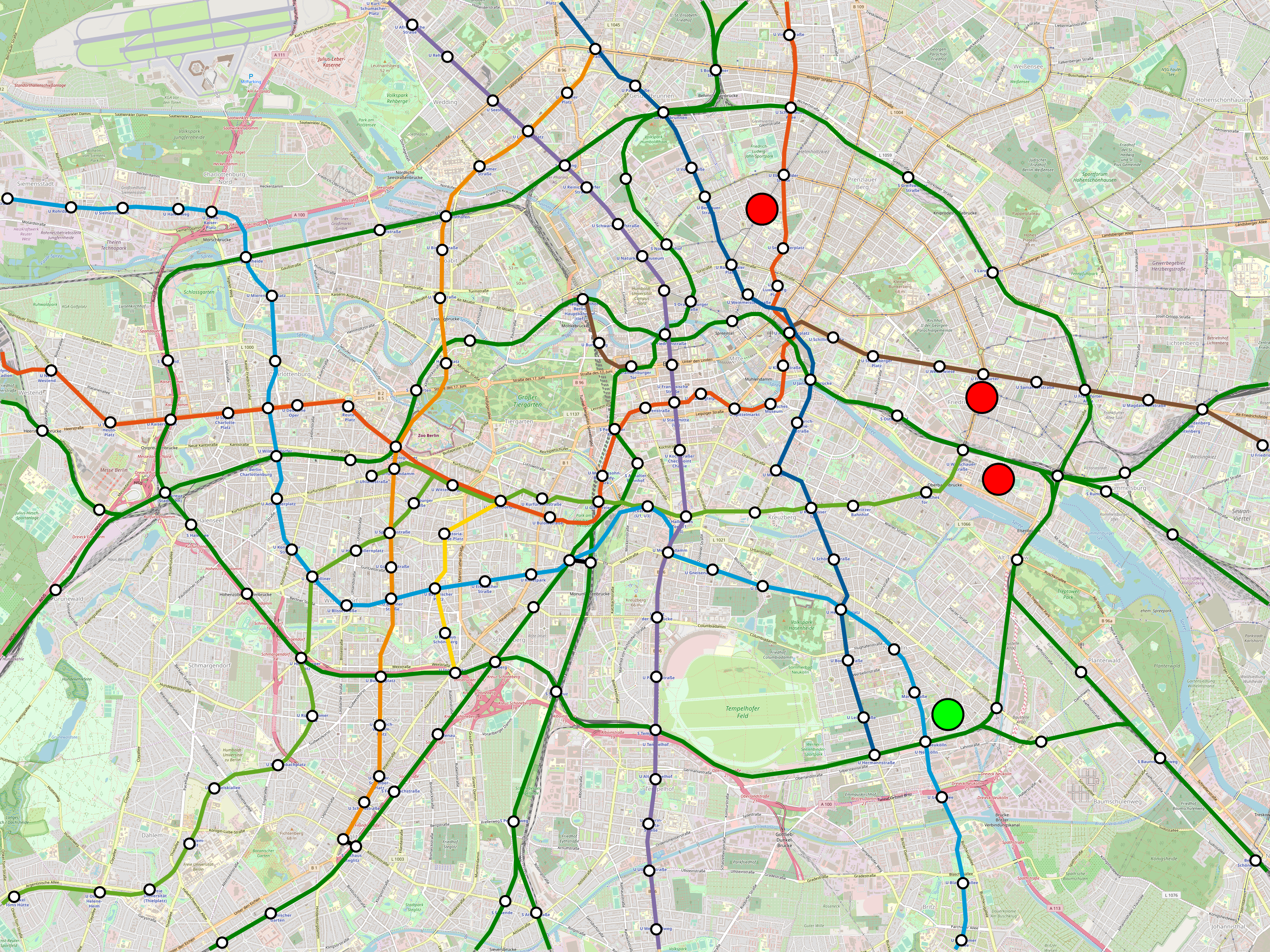
The problem can be summarized with the following map, in which the green dot is where I live and the three red dots are places I’ve gone to recently:
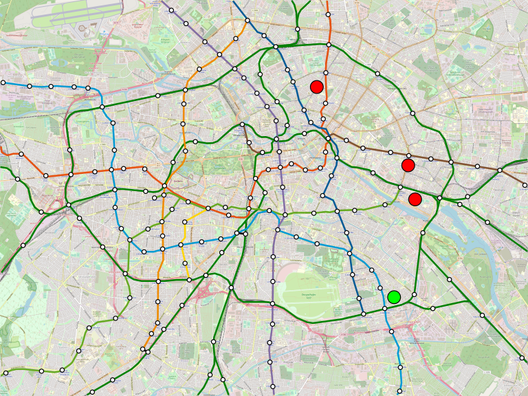
A larger 13 MB image can be seen here.
My trips to the two southern red dots, both gaming events, are not too onerous, using the Ringbahn. But my trip to the northern red dot isn’t so easy; besides being circuitous, the Ringbahn is currently shut down for maintenance for a segment in between. Now, there’s redundancy, I can still get there, but it requires a three-seat ride involving U7, U8, and U2, and what’s more, the U8/U2 transfer at Alexanderplatz is long.
The route U7 takes is a Cold War relic. During the division of Berlin, city center was in East Berlin, forcing West Berlin to build a new city center, currently called City West. East Berlin got the S-Bahn, which West Berliners eventually began to boycott even when it served the West, and West Berlin got nearly the entire U-Bahn, with the exception of just U5 and the eastern parts of U2. U6 and U8 served West Berlin going from the north to the south without stopping in the Walled center. To provide entirely Western routes, West Berlin built two new lines, U7 and U9.
The decisions made about U7 and U9 routing were then about the context of the Wall. U9 is a straight north-south trunk passing through City West, with connections to every West Berlin U-Bahn line with the exception of the low-ridership U4 stub. U7, originally part of the U6 mainline south of their junction, was extended northwest to become a new trunk line, and it too is designed to connect to the U-Bahn network of West Berlin alone rather than to the combined one. Thus, there is a reasonable U7-U1 connection at Möckernbrücke, but instead of continuing due west to connect with U2, U7 detours southwest and only connects with U2 at Bismarck Strasse, too far to the west to be of use for people connecting between the two lines’ eastern legs. In the Cold War, this worked, in the sense that the parts of U2 on the Western side of the Wall are either still convenient with the Bismarck Strasse transfer or very close to U1. In the context of reunification, this doesn’t work so well.
Here is a map of passenger rail traffic by interstation segment:

Note that U9 goes strong throughout its run; while the area it serves is no longer the CBD, it is still a strong high-end retail center, defined around Kurfürstendamm. However, U7’s traffic actually peaks in Neukölln and Kreuzberg and is lower west of the junction with U6 at Mehringdamm. Moreover, coming from Spandau at the other end, U7 loses traffic as it crosses the Ringbahn (as do many lines coming from the west) rather than gaining it. The shift in the center of the city has rendered U7 a mixed radial-circumferential line.
Paris
Like Berlin, Paris has a radial mainline rail network and a more complicated dedicated urban rail system.

The Metro defies easy categorization. It has the characteristics of a grid, with Lines 1, 3, 8, 9, and 10 running east-west, and Lines 4, 5, 7, 12, and 13 running north-south. It also has the characteristics of two overlain radial networks, one consisting of Lines 1, 4, 7, 11, and 14 around Chatelet, and one consisting of Lines 3, 7, 8, 9, 12, 13, and 14 around the Opera and Saint-Lazare. Some support for the latter view is that the weakest lines are M5 and M10, passing respectively too far east and south of city center.
Out of 14 Paris Metro lines, only two can connect to every other line in the network, M4 and M9, and the latter has an unadvertised connection from Saint-Augustin to Saint-Lazare, without which no transfer to M12 or M14 is possible.
This is not quite as dire as it may seem at first glance. So many stations are transfers, and stations are spaced so close together, that even though M1 runs parallel to M3 and M10, nearly all intra muros M1 stations still have two-seat rides to M3 and M10 via a different line.
Nevertheless, some parts of the city are poorly connected as a result. Eastern Paris’s connections to the Left Bank are not good. Some are more circuitous than they need to be, such as between a dorm I stayed at near Porte de Vincennes in 2010 for a conference and the site of the conference itself at Jussieu. Some are three-seat rides. Most involve changing trains at Chatelet, which adds 5-7 minutes to the trip in walking time alone.
In the case of Berlin, explaining how it got this way requires going into Cold War history. In that of Paris, a city with continuous development, this is just a matter of uncoordinated layers of planning. The plan from the 1890s produced M1-6, shaped as a hex symbol inside a circle; the lack of connection between M1 and M3 was not thought a problem then, and the remaining lack of connectivity if one originates in the suburbs was never a planning priority either.
There is another way
Paris may have Europe’s largest rail network, and Berlin may have the fourth largest, but they are in this sense atypical. London’s radial Underground network provides better connectivity, and the radial typology is increasingly dominant as Chinese metro networks follow the Soviet model, which is even more strictly radial than the British one.
The distance between my apartment and the northernmost red dot on the Berlin map is 8 kilometers. I looked at similar 8-kilometer trips within Inner London, picking two different starting points at Brixton and Bromley-by-Bow. Each 8-kilometer trip passing through or near Central London had a viable one- or two-seat ride, with the exception of Brixton-Canary Wharf, which is a three-seat ride with a cross-platform interchange at Stockwell.
There are a lot of defects in the London Underground network, and the two starting points I picked are somewhat cherrypicked to avoid them. Every pair of London Underground main lines intersects with a transfer, except the Metropolitan line and the Charing Cross branch of the Northern line, which have a missed connection at Euston and Euston Square; my two starting points are on neither of these two lines. Moreover, going northwest, there are some suburban missed connections between branches. This is on top of serious problems with capacity coming from the trains’ small size.
However, it’s notable that nobody is reproducing the small profile of the Tube networks. What cities around the world are reproducing is the radial network design, in which most trips within the urban core are reasonably direct. Going forward, Paris may even consider building connections between Metro lines to make its network more radial, for example extending M11 to the west. Berlin, likewise, should look to invest in radial S-Bahn trunks, following the busiest corridors connecting more areas to and beyond Mitte, where it’s already building extensive office space.

In the course of potential U7 extension to BER there is some debate as to how long an U-Bahn line can get before it gets too long. What do you think? Either in terms of length or in terms of travel time?
By the way, the 200 km plan was always officially written in a way that ignored partition. This might explain the lack of U-Bahn to Tegel; they planned the U5 for that…
I don’t mind the length so much as the coverage. U7 isn’t really great for Berliners flying out of BER. It’d be great for me, but everyone else would rather get an S-Bahn or RegionalBahn. For arriving passengers it’s almost completely useless – the high-end hotels are in Mitte and near the Zoo station, nowhere near U7. Generally you want to connect to international airports by mainline rail rather than the metro.
What about the people working at the airport?
Do they particularly cluster in Neukölln? If not, they can ride the regional trains and S-Bahn too.
I mean they certainly COULD cluster there if there were better access.
Plus Schönefeld really wants a subway stop
How much job security is there for airport workers in Germany? Because in the US working-class jobs tend not to have much security, so airport workers can’t orient their lives based on a single job site; people who work at LaGuardia really do live all over New York.
Hamburg’s U1 (Norderstedt Mitte – Großhansdorf) has a travel time of 84 minutes and thus much more than Berlin’s U7 with 56 minutes, but both lines run fine.
It would have been easy to open the western part of U5 to TXL as a branch of U7 from Jungfernheide instead, because at this stations the already prepared U5 platforms are in the same level as the U7 platforms in the same direction, respectively, so the partition can’t be the reason.
I don’t think that U7 is completely useless, as there are frequent buses between Rudow, so that the district Neukölln is in favor of the metro extension. The S-Bahn to BER runs very indirectly, coming from the eastern city center but approaching the terminal from the western side. There is another option which would be perhaps cheaper than the U7 extension would be a branch of S2 from Lichtenrade – see our proposal here: https://www.zukunft-mobilitaet.net/142969/urbane-mobilitaet/s-bahn-querverbindung-lichtenrade-verkehrsanbindung-flughafen-berlin-brandenburg-ber/
While for airports located far from the city should it may be sufficient to connect them by one mainline rail line, there is some geometrical reasoning that an airport close to the city should be connected by several mainline rail and/or metro lines, because otherwise the car can be faster on many connections, assuming that it can drive as the crow flies.
The S2 extension only works if you can cut off Blankenfelde. Otherwise you can’t really run the line frequently – there’s already S1 and S25 sharing the North-South Tunnel, so you’re stuck running trains every 20 minutes. You can split trains at Mahlow as the article proposes, but does that really work with current schedule precision? Tokyo splits trains all the time, but only really far out of the city, and on lines with Japanese punctuality rather than German punctuality.
Is there any public data on where people flying out of Berlin are going to within Berlin? In New York there’s such data for LGA for the various rail and bus connection studies, and it turns out that airport travelers are almost always going to Manhattan, so there’s no real need for everywhere-to-everywhere transit.
S2 is operated every 10 minutes to Lichtenrade and only every 20 minutes to Blankenfelde, so every other train could go from Lichtenrade to BER now (as long as Blankenfelde doesn’t get an S-Bahn service every 10 minutes in the future).
I’m not aware of any general public data. If you find something, let me know! Maybe there is some airport-specific survey?
Yeah, so the problem is that this way S2 serves the airport every 20 minutes, which is a large fraction of the one-way trip time. It’s especially bad for arriving passengers, since they arrive at essentially random times, so there’s no way for them to time themselves to just make the train, whereas people who walk to the train station to catch the train to the city can make sure to get to the train just in time.
Indeed, this might be a problem. Splitting airport S-Bahn trains is practiced in Hamburg and Munich, so it’s generally possible even with German punctuality, but the problem is that the current Berlin S-Bahn trains don’t allow it, if I remember correctly.
Splitting airport trains is undesirable as it confuses tourists
If you think the Alexanderplatz walking transfer is long, curious what you think of London transfers like Green Park, Holborn, or King’s Cross St Pancras 🙂
Personally I’d much rather a two-transfer trip via Hermannplatz than a one-transfer trip changing from Piccadilly to Victoria at Green Park. Conversely, I intentionally went via Green Park when commuting from Camden to Hammersmith (around 9km straight line), because Victoria line is much faster through Zone 1 (radial format, but also wide stop spacing), and the cross-platform transfer at Euston was much better than dealing with Leicester Square. (Then after a while I started taking Overground going around the houses via Willesden Junction then bikeshare from Olympia because tube crowding was impossible.)
Hermannplatz is fine, but Alexanderplatz really isn’t.
I know I’ve used Green Park, but I forget if I changed trains there. I don’t remember any transfer in London being as bad as Chatelet-Les Halles or any number of other complex Parisian stations (or for that matter Shanghai Railway Station).
I used Green Park a lot during my 20 years living in Europe, as I used the Victoria line. I seem to be a bit resilient to long transfers, so while I remember it, what I remember as an irritant was the long wait for trains. I am told that these things have improved a lot in London so perhaps it is different these days. As long as I am moving, whether walking or in a moving train, then I’m in a fair mood (which is why Chatelet never irritated me the way it does Alon!). But the two dominant memories of LU is the long wait for trains to arrive, and then sometimes (on some lines) the even more irritating wait on a stationary train. (Of course a third irritant was the expensive and nit-picking ticketing.)
I mean if you are using the Metro to get somewhere then you can easily avoid using Chatelet (unless you need to transfer to the RER but even then you can usually choose to change before Chatelet). Examples are M1, M4, M7 and M11 which have correspondances at the Chatelet end (versus les-Halles) with themselves. Also, in both Berlin & Paris you ignore the very real option of walking at beginning and/or end of the journey. One of your journeys in Berlin looked walkable all the way–at probably the same or less time and higher reliability. The distances are not so great–unlike London or NYC where they can be considerable (and the maps can be somewhat misleading). OK, there’s the weather issue …
Incidentally Paris-M7 connects to all Metro lines except M13 and RER-C & -E. M4 and M7 make so many connections because they describe a big S from north to south of Paris; they cross several lines–including each other–twice giving even more options. M4 is often considered the line to live next to, especially as it serves the hot-spots (Denfert-Rochereau, Montparnasse, Leftbank (St Sulpice->St Germain–St Michel), Cité, Rightbank, and four of the big transport interchanges of Gare Montparnasse, Chatelet (two stops), Gare de l’Est and Gare du Nord).
Anyway, in the broader context of your article, while Paris Metro is very functional, and one can draw some lessons from it, the thing is no one would build a system like it anymore. Inter-station spacing is too short and overall density is too high; exactly the things that make it so good if you live in central Paris, but a legacy of an older Paris. Indeed, as you know, M14–opened in 1998–shows how they would build the Paris Metro if they were to start afresh; for the reasons that it is much faster (traversing the city in much shorter times) and is being extended, at both ends, deep into the suburbs which is something the older Metro lines can’t do without suffering time and congestion penalties. But while the current M14 is radial, its future form is a mixture because it turns more circumferential in the southern section. So, given that the most connected lines are M4 & M7, and these two are the second and third most-used lines, perhaps the future should be S-shaped or maybe zig-zag-radial?
As long as the walks aren’t as long as in Istanbul.
My brother who’s lived in both Mexico City and Berlin says the walk between connections in DF is sometimes longer than the interstation in Berlin…
S-shaped and zig-zag means unnecessarily slow trips.
The only models that are worth considering for top-down design are radial and grid.
Of course, each city has many of its own peculiarities, so the ideal network for it is not *exactly* radial or grid.
Your first sentence contradicts your final sentence.
And Paris M4 & M7 also contradict whatever a theoretical analysis might predict. And a big part of their usefulness is the very fact that they serve more big destinations than other lines (except arguably M1) and they couldn’t possibly do that if they were not S- and zig-zag. Efficiency cannot be defined by some mindless algorithm that measures things in straight lines or transit times, though as usual I would argue it is simply that the model is defective as it is only considering a fraction of the relevant issues. For example it is arguable just how much would be saved; it would be negative for all those people trying to get to those big destinations that otherwise would have to use a 2-seat ride or worse.
M7 isn’t that busy, though… relative to its length its ridership is middle of the pack; ridership per km goes M1/4, M14, M2, M6, M11.
You’re right that some zigzags with multiple crossings are acceptable. However, London actually does that better than Paris. The best place for zigzags is if you have a subpart of the city with a strong identity, such that it’s really useful to have a coherent internal network. Examples include South London and the Left Bank. In that case, the role of the zigzag is to ensure that every reasonable trip within the subpart can be done internally. Paris does not actually provide this, though – there are Left Bank-to-Left Bank trips for which the best option involves connecting on the Right Bank. London does provide this, provided you define South London to exclude the Wimbledon branch of the District line (and my understanding of London sociology is that that area is way posher than the rest of South London).
“Your first sentence contradicts your final sentence.”
No, because the deviations from the ideal network are minor.
For example, Berlin’s U6 can be characterized as a north-south line. It is not exactly north-south, and not exactly a line. But the deviations are small enough that they do not noticeably affect ridership patterns.
Re Wimbledon: that is essentially true.

I don’t know if defining it by kilometre is especially useful. It is still the third most heavily used line with >120m per year. It’s the longest line because it extends deeply into the suburbs both north and south. FWIW it’s pax/km is ≈50% higher than London’s Northern Line (London’s busiest IIRC). It has pretty good traffic for not
passing thru any of the mainline stations or centres except Chatelet (oh ok, Opera, Grand Magasins & Gare de l’Est).
Perhaps what you say about London is correct though I haven’t quite grasped your meaning re South London since there is so little of the Underground there. And I definitely don’t get what you mean by: “there are Left Bank-to-Left Bank trips for which the best option involves connecting on the Right Bank.” One of M4’s eastward zigs covers all of the historic Left Bank, ie. St Sulpice, St Germain, Odeon, St Michel. I often used M10 because of coming from M7-south and changing at Jussieu; this line covers all of historic Left Bank (more really with Maubert-Mutualite, Cluny-Sorbonne), plus Sèvres-Babylone for Bon-Marché, then Duroc for Pasteur Institute. (And separately RER-C covers all of the left bank of the Seine.)
On the issue of zig-zags, of course M4 does a big westward one specifically to pass by Montparnasse (and connect it to Denfert-Rochereau), and further north another westward one that connects Gare de l’Est to Gare du Nord.
My (poor) understanding of London socio-geography is that Wimbledon does not call itself South London. Perhaps south-west London. Wimbledon is posh and adjoins Richmond which is even toff-ier (it’s where Sir Mick had/has his London base). Though the odd thing is that they get Heathrow flyover all the time.
Sarf London generally means Brixton, Clapham etc.
I didn’t quite understand the South London/Underground thing either, though perhaps Alon was referring to mainline rail (which makes many local stops there).
Wikipedia: Paris M7 has 120M riders on a 22km line. London Victoria Line has 200M riders on a 21km line.
Eric 2019/05/16 – 02:58
I was comparing it to the Northern Line (not Vic) which carries about 250m on 55km. The NL is multi-branched*. M7 is also branched, one of only a few Paris metro lines that are; IIRC the new M14 southern extension is going to eventually takeover the Villejuif branch to the suburbs, and the M14 northern extension, currently being built, is going to take over one of the M13 branches to simplify these lines. It seems like they still need to do something like this to the Northern Line.
*It is the branching that caused the problems that gave it the name Misery Line. Rob Bell’s tv doco on London Underground showed how horrendous it is. Eventually the switching mechanism was upgraded to something much more robust but he showed how it needs tending every night–not once a week or whatever, but every single night, and by a team of about a dozen engineers and others, and it pretty much takes them the whole period of closure to complete it. Ridiculous. It’s because it’s a 4-way junction, combined with its heavy use. The LU had too many of these kludges which were a legacy or result of combining old private lines into a single network. Bell showed how the Northern Line was cobbled together from 4 different-guage tunnels and pushed further into South London by using what was originally a turning loop; it was a tight curve never intended for pax-carrying trains but a new station was built on it and this is where the (in)famous “mind the gap” comes from, ie. the curvature left significant gaps between platform & train.
The Tube was not completely unplanned, though. Parliament had to approve the routes, and did require companies to coordinate, which is why Central London has interchange stations where you expect them and only one legacy missed connection. The real missed connection disaster in London is between branches that interweave without transfers, but that also exists on Transilien and the RER. Both cities keep planning on new missed connections for silly reasons.
Victoria Line is a better comparison, though, as it’s about the same length. Northern Line goes out to low-density suburbs which cuts the ridership per km.
urbanrail.net shows the M14 extensions intersecting M7 and M13 but not taking over their branches.
On that basis the Northern Line is the better comparison because M7 goes to lower-density suburbs, both north and south. That is why it is the longest line (about the same as M8 & M13, both of which also go deep into the suburbs).
Anyway for exactly these reasons, I don’t agree with Alon’s econocratic reduction of a line’s traffic to pax per km. The NL has the most pax but a low pax/km but that is meaningless, and it very clearly should do something about its branching which is overloading “the” line and simultaneously stressing the switching and therefore timely running. You know, the entire time I lived in Paris (and another 10 years of visiting) I cannot remember a single Metro stoppage (other than strikes). I’m sure it must have happened–and it apparently happened on RER-A due to its super-crowding. But I doubt there is anyone alive who hasn’t experienced stoppages or delays in London, all the time. Despite what Alon wrote, it clearly suffers from being a less coherent, cobbled-together system and one subject to continuous austerity (which is why these problems have never been properly fixed, just bodged).
Incidentally if we use Alon’s metric then Paris is more than twice as “busy” as LU. Paris-Metro has about 7m pax pa/km while London has 3.4m pax pa/km. But if you use Metro + RER (which is the sensible comparison) then they are almost the same with the Paris figure now being ≈3.8m pax pa/km. If planners actually used this metric then they would never have built the RER (or Crossrail) because they have a much lower pax per km, and so look horribly “inefficient” compared to metro.
It still looks a bit ambiguous to me.The urbanrail wording is “connected to one of the northern branches of ligne 13” and similar for the Villejuif branch of M7. Duplicating those approx. 5km subterranean sections seems extravagant especially when M14’s function is to explicitly relieve M13’s congestion; the current tunnel is being bored to Mairie-St-Ouen so it seems logical it would use the existing M13 for the final northerly approx. 5km bit to St-Denis. But then it would have been equally logical, and a lot cheaper, to have only bored to La Fourche and taken over M13 north-east branch from there (and completely removed the branching)? Likewise on the southern extension it would seem perfectly logical to takeover the Villejuif branch all the way from Maison-Blanche. M14 is destined to Orly and that is a straight line continuing on from Villejuif-Louis-Aragon. The official stuff talks about a 14km extension but only 4km (?) of new tunnel so …. But then it also talks of “a new, more westerly route as part of the Nouveau Grand Paris network” … . If they remain separate then it seems very extravagant duplication of lightly used suburban segments. The Villejuif segment was built in the 80s and has giant cavernous stations not unlike M14.But ok, the map (link below) shows the reason: a main interchange at Institute Gustav-Roussy (the biggest cancer hospital in Europe and my old workplace, maybe a 1.5km walk west from M7 Villejuif-Paul-Vaillant-Couturier) with M15; perhaps tied into this hospital and research centre (lots of CNRS, INSERM etc centres here). The French planners love these tech-poles (and they’re correct). It is also practically on top of the A6 autoroute so does look like a serious transport node.
https://prolongementligne14-orly.fr/#lignes/14SU
Berlin certainly has missed connections that require multiple-transfer trips, but they are not due to a grid layout (most seem to be due to changes in travel patterns due to the Cold War, as you describe). In an actual grid, you can get from anywhere to anywhere with at most one transfer. If anything, the high patronage of parallel routes such as U8/U9 indicates that the grid pattern is successful in Berlin (to the extent that it exists).
The point is that a rapid transit network will never be a complete grid, not even in Beijing, and as soon as you start missing some grid lines, you start requiring three-seat rides.
Or you use tramways to fill in the missing lines…
How does the grid of the Paris metro compare to the RER? It looks like all the RER lines are radial except for the cobbled togerther RER C.
Yeah, the RER is radial. But the RER-Metro interface isn’t that great – the transfers are long, and in some important cases are missing entirely (e.g. RER B to M3, M8, and M9, and RER A to M12 and M13). So for the most part these are two separate systems and you can take either within the city, even though in some cases you can use both.
I think you’re trolling, but ok:
By any measure the RER system is well interconnected to the Metro system and the other RER lines and mainline rail. If you are commuting in from the suburbs you would need only a 2-seat ride to get to almost anywhere in Paris.
Inside Paris the 5 RER lines have 35 stations and these have 65 Metro interchanges, 18 RER stations, 5 of the 6 mainline rail stations (only missing Montparnasse).
RER-A has 6 stations, all of which are interchange stations with 19 Metro stations (10 different lines), 4 RER stations (3 lines), one Tramway and one mainline rail (Lyon).
RER-B has 7 stations, 5 of which are interchange stations with 12 Metro stations (serving 9 different lines), 5 RER (all lines), one mainline rail (Nord) and one Tramway.
RER-C has 16 stations of which 14 are interchange stations, with 16 Metro stations (serving 11 different lines), one RER (B), one mainline rail (Austerlitz) and one Tramway.
RER-D has 3 stations all of which are interchange stations, with 10 Metro stations (serving 8 different lines), 5 RER (3 lines) and two mainline rail (Nord, Lyon).
RER-E has 3 stations all of which are interchange stations, with 8 Metro stations (8 different lines), 3 RER (3 lines), one mainline rail (St-Lazare) and one Tramway.
The number of interchange stations is less important than which orthogonal lines there is interchange with. The RER B interchanges with three lines that run east-west crossing it: M6 at Montparnasse, M10 at Saint-Michel (sort of), M1 at Les Halles. It misses M3, M8, and M9 entirely, and misses M2 unless you count La Chapelle as connected to Gare du Nord, which you really shouldn’t. The RER A interchanges with the M2/6 ring twice and with M4 and M7, but misses M5, M12, and M13. Contrast this with Berlin, where, if you allow for single-station backtracks, there is exactly one missed connection, namely between U1 and the North-South Tunnel.
Since Paris has so many passengers same direction would probably be more important. It would be nice if the RER trains were across the island platform from the Metro trains, wouldn’t it?
I think you are nitpicking–and applying theoretical rules that may be less important than you imagine in the reality. I don’t have enough experience of Berlin, but since so much is elevated it can build it more flexibly. I wouldn’t want that for Paris. Given this restriction (of being mostly underground and mostly following major boulevardes) it is remarkably effective and efficient. By my count (as per previous comment) the RER system gives you 170 transfer options to other transit (mostly Metro) within Paris.
Your complaints about RER are all superfluous when one can quite simply do a transfer if needed. Like so much in life, we tend to grumble about the imperfections but rapidly habituate to the reality, and I would argue that in Paris that reality is not at all a strain (in some other cities, eg. London, not so much–btw this is why CrossRail, their first RER, will be such a revelation to Londoners). Re your complaints about RER-B: no. It was the only RER line I used regularly (as Metro and less often to get to the airport). You can’t have it both ways (though I’d argue RER does almost manage it), ie. intersecting a lot with Metro inside Paris, and being a much faster service (getting out of Paris, or across Paris) which was its primary design purpose. In fact RER-B connects at extremely useful points, namely Denfert-Rochereau, StMichel-Notre-Dame, Chatelet and Gare du Nord. It has two connections to “my” M7. In fact, all the time I lived in Paris, at four different locations–in Cité Universitaire (14th), Ile St Louis (4th), 5th and 10th–it turns out I was always within easy walking distance of RER-B for those airport trips, ie. without a transfer.
Now, perhaps it is theoretically feasible to have built RER to more comprehensively connect to the Metro. I know you have your crayon scheme of repurposing the RER-C northern section, but given the incredibly tight urban fabric of Paris (and its astounding heritage status) I remain sceptical of how much better it would be. OTOH, why is Berlin better (and how much better)? Is it partly because they could (re)build more freely in a destroyed city, or they could build elevated? Or is it all just Germanic efficiency, Vorsprung durch Technik? And actually I happen to think that the decision to build the gigantic interchange station of Chatelet-les-Halles, with RER (3 lines) + Metro (5 lines), in the heart of Paris was an astoundingly good one—-and in the 1970s. With more than 40 years of retrospective wisdom, how much better could one design it?
To get to the northern red dot from Neukoelln, one could change once at Hermannplatz, get off at Rosenthaler Platz and walk 10 minutes. (There’s also a tram). Doesn’t seem significantly farther than from the other stations.
It’s a bit closer to Bernauer Strasse, but yes; when I lived at Bernauer Strasse, I’d walk, which is how I found these restaurants. There’s M10, but it’s not faster than walking net of wait time.
Can’t Trump fire everyone in Amtrak? Between this and $300 billion they want to spend on the nec, this is getting ridiculous. Why electrify MBTA, why not just do a fraction of it and use Battery EMU, like the Talent 3, for the rest?
Battery EMUs don’t have the juice. Lugging the entire power plant instead of receiving power via catenary adds a lot to weight and requires making serious compromises on performance.
And Trump only fires people on The Apprentice – in reality he’s a hesitant, indecisive leader in constant panic mode.