Assume Normal Costs: An Update
The maps below detail what New York could build if its construction costs were normal, rather than the highest in the world for reasons that the city and state could choose to change. I’ve been working on this for a while – we considered including these maps in our final report before removing them from scope to save time.
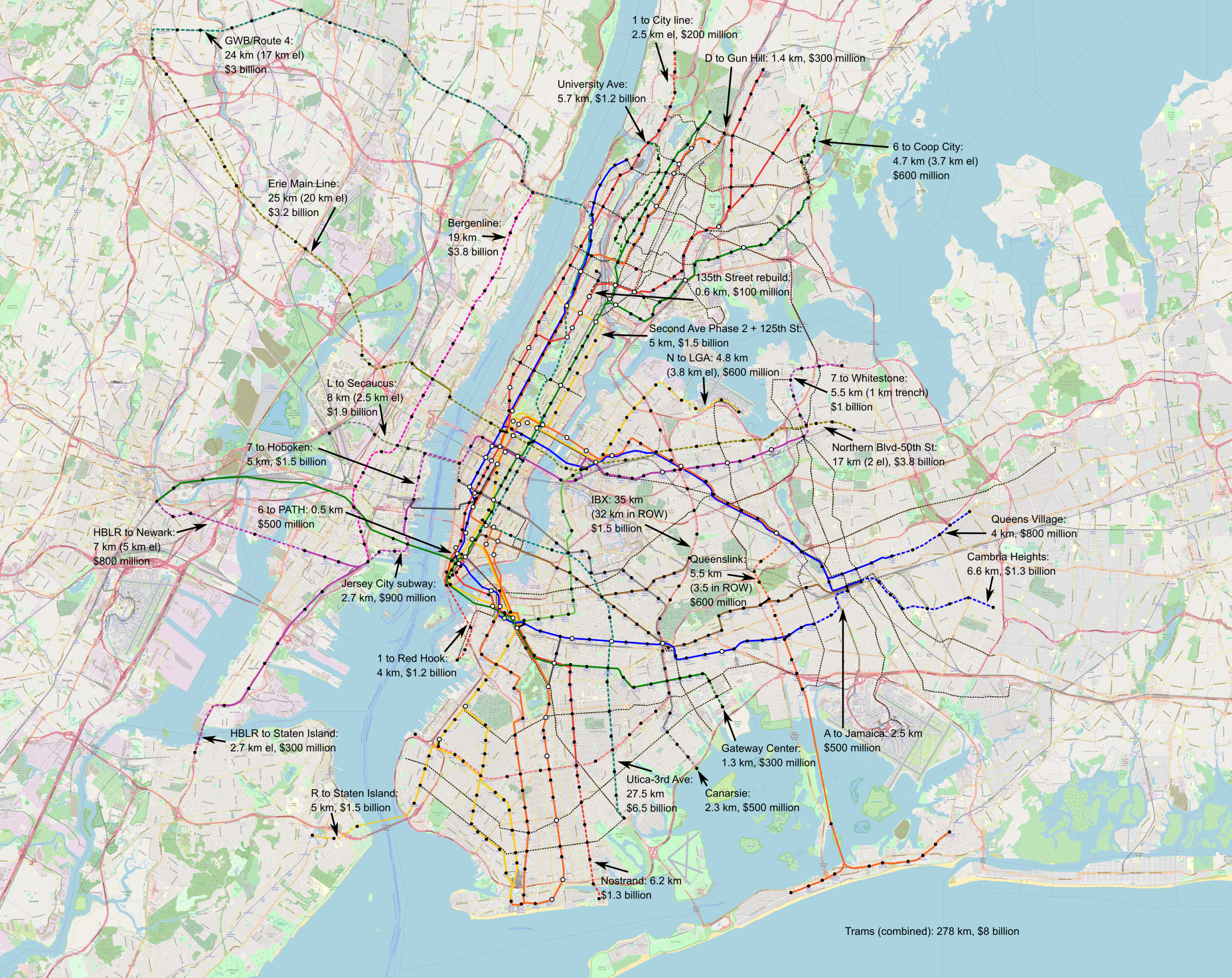
Higher-resolution images can be found here and here; they’re 53 MB each.
Didn’t you do this before?
Yes. I wrote a post to a similar effect four years ago. The maps here are updated to include slightly different lines – I think the new one reflects city transportation needs better – and to add light rail and not just subway and commuter rail tunnels. But more importantly, the new maps have much higher costs, reflecting a few years’ worth of inflation (this is 2022 dollars) and some large real cost increases in Scandinavia.
What’s included in the maps?
The maps include the following items:
- 278 km of new streetcars, which are envisioned to be in dedicated lanes; on the Brooklyn and Queensborough Bridges, they’d share the bridges’ grade separation from traffic into Manhattan, which in the case of the Brooklyn Bridge should be an elevated version of the branched subway-surface lines of Boston, Philadelphia, San Francisco, and most German cities. Those should cost $8 billion in total, based on Eno’s European numbers plus some recent urban German projects.
- 240 km of new subway lines, divided as 147.6 km in the city (97.1 km underground) and 92.4 km across the Hudson and in New Jersey (45.2 km underground). Of those 240 km, 147.5 km comprise four new trunk lines, including the already-planned IBX, and the rest are extensions of existing lines. Those should cost $25.2 billion for the city lines and $15.4 billion for the New Jersey lines.
- Rearrangement of existing lines to reduce branching (“deinterlining“) and improve capacity and schedule robustness; the PATH changes are especially radical, turning the system into extensions of the 6 and 7 trains plus a Hoboken-Herald Square shuttle.
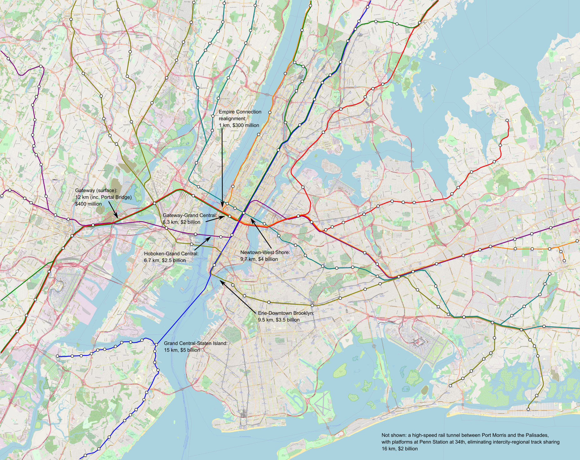
- 48.2 km of commuter rail tunnels, creating seven independent trunk lines across the region, all running across between suburbs through the Manhattan core. In addition to some surface improvements between New York and Newark, those should cost $17.7 billion, but some additional costs, totaling low single-digit billions, need to be incurred for further improvements to junctions, station platforms, and electrification.
The different mode of transportation are intended to work together. They’re split across two maps to avoid cluttering the core too much, but the transfers should be free and the fares should be the same within each zone (thus, all trains within the city must charge MetroCard/OMNY fare, including commuter rail and the JFK AirTrain). The best way to connect between two stations may involve changing modes – this is why there are three light rail lines terminating at or near JFK not connecting to one another except via the AirTrain.
What else is included?
There must be concurrent improvements in the quality of service and stations that are not visible on a map:
- Wheelchair accessibility at every station is a must, and must be built immediately; a judge with courage, an interest in improving the region, and an eye for enforcing civil rights and accessibility laws should impose a deadline in the early to mid 2030s for full compliance. A reasonable budget, based on Berlin, Madrid, and Milan, is about $10-15 million per remaining station, a total of around $4 billion.
- Platform edge doors at every station are a good investment as well. They facilitate air conditioning underground; they create more space on the platform because they make it easier to stand closer to the platform edge when the station is crowded; they eliminate deaths and injuries from accidental falls, suicides, and criminal pushes. The only data point I have is from Paris, where pro-rated to New York’s length it should be $10 million per station and $5 billion citywide.
- Signaling must be upgraded to the most modern standards; the L and 7 trains are mostly there already, with communications-based train control (CBTC). Based on automation costs in Nuremberg and Paris, this should be about $6 billion systemwide. The greater precision of computers has sped up Paris Métro lines by almost 20% and increased capacity. Together with the deinterlining program, a single subway track pair, currently capped at 24 trains an hour in most cases, could run about 40 trains per hour.
- Improvements in operations and maintenance efficiency don’t cost money, just political capital, but permit service to be more reliable while cutting New York’s operating expense, which are 1.5-2.5 time a high as the norm for large first-world subway systems.
The frequency on the subway and streetcar lines depicted on the map must conform to the Six-Minute Service campaign demand of Riders Alliance and allies. This means that streetcars and subway branches run very six minute all day, every day, and subway trunk lines like the 6, 7, and L get twice as much frequency.
What alternatives are there?
Some decisions on the map are set in stone: an extension of Second Avenue Subway into Harlem and thence west along 125th Street must be a top priority, done better than the present-day project with it extravagant costs. However, others have alternatives, not depicted.
One notable place where this could easily be done another way is the assignment of local and express trains feeding Eighth and Sixth Avenues. As depicted, in Queens, F trains run local to Sixth Avenue and E trains run express to Eighth; then, to keep the local and express patterns consistent, Washington Heights trains run local and Grand Concourse trains run express. But this could be flipped entirely, with the advantage of eliminating the awkward Jamaica-to-Manhattan-to-Jamaica service and replacing it with straighter lines. Or, service patterns could change, so that the E runs express in Queen and local in Manhattan as it does today.
Another is the commuter rail tunnel system in Lower Manhattan. There are many options for how to connect New Jersey, Lower Manhattan, and Brooklyn; I believe what I drew, via the Erie Railroad’s historic alignment to Pavonia/Newport, is the best option, but there are alternatives and all must be studied seriously. The location of the Lower Manhattan transfer station likewise requires a delicate engineering study, and the answer may be that additional stops are prudent, for example two stops at City Hall and South Ferry rather than the single depicted station at Fulton Street.
What are those costs?
I encourage people to read our costs report to look at what goes into the numbers. But, in brief, we’ve identified a recipe to cut New York subway construction costs by a factor of 9-10. On current numbers, this means New York can cut its subway construction costs to $200-250 million per kilometer – a bit less in the easiest places like Eastern Queens, somewhat more in Manhattan or across water. Commuter rail tunnel costs are higher, first because they tend to be built only in the most difficult areas – in easier ones, commuter rail uses legacy lines – and second because they involve bigger stations in more constrained areas. Those, too, follow what we’ve found in comparison cases in Southern Europe, the Nordic countries, Turkey, France, and Germany.
In total, the costs so projected on the map, $66.3 billion in total, are only slightly higher than the total cost of Grand Paris Express, which is $60 billion in 2022 dollars. But Paris is also building other Métro, RER, and tramway extensions at the same time; this means that even the program I’m proposing, implemented over 15 years, would still leave New York spending less money than Paris.
Is this possible?
Yes. The governance changes we outline are all doable at the state level; federal officials can nudge things and city politician can assist and support. There’s little confidence that current leadership even wants to build, let alone knows what to do, but it’s all doable, and our report linked in the lede provides the blueprint.

I wrote a post to a similar effect four years ago.
And they are still as hilarious as they were then. The cat wasn’t here this time, so she didn’t frightened from the laughing.
Why do you hate post on this blog? You always have pointed or even angry criticism, but then you’re still in the comment section everywhere.
I don’t think it’s hateposting. For context, someone once said that Adi and I argue like an old married couple… in 2010 or so, in comments on another blog.
The same reasons millions of other bitter people post on social media.
The Manhattan Rail Tunnel will be a critical piece of infrastructure. Alongside with a revamp in rail operation and fare structure, it can bring quality transit to millions of people.
So streetcars at “normal” costs are about $30m per km? That’s also how much they tend to be in the dinky little streetcar circulator projects in transit desert cities in the US.
Interesting that what you propose would give NY the biggest streetcar network in the world (surpassing Melbourne), but it would still only be an auxiliary network to the subway, much like the tramways in Paris. I like the revival of Brooklyn bridge terminus.
Do you have a formula for “normal” subway construction costs that would split out the tunnels and the stations? Something like, $100m per/km for just the tunnels, plus $200m per station. This would help with these kinds of proposals.
The plans are still very pharaonic. I’m guessing the priorities would be something like (in order):
1. Subway de-interlining and frequency improvements
2. Regional rail trunk lines and integration
3. Urgent subway extensions like 125th St, Nostrand, Utica, N to LGA, maybe 6 to Co-op City
All the other stuff is a pretty longterm horizon.
Just making PATH a regular part of the subway (integrated fares, depicted on maps, given their own line letters and colours) would be basically free and go a long way to making it more useful and unlocking chunks of NJ for development.
Piggybacking off the streetcar question: How much ‘should’ light rail cost? Seems that can’t be delivered for under $200 million/km in the US. But it’s just a streetcar, sometimes elevated? What would that cost internationally?
There are American streetcars delivered for not much more than the European costs; Eno found that the US premium is not large for such projects, and while I think Eno’s European database is a bit upward biased, this is only a bit. A $30 million/km budget is not outlandish; there are real problems with betterments and other such bullshit, but they’re resolvable.
“[trams] which are envisioned to be in dedicated lanes; on the Brooklyn and Queensborough Bridges”
Neither the Brooklyn nor Queensboro can support the tram loading. They never could. There were severe restrictions on spacing between trams and elevated trains, when there was rail service in these bridges.
The Brooklyn underwent a complete redesign in the early 1950’s. The middle longitudinal trusses were removed. The roadway’s wooden paving blocks were replaced by “light weight” concrete. This resulted in lowering the bridge’s live load. The roadway dips at the towers. The dip is the result of trolley car overloading incident that occurred within a year of their introduction.
The Queensboro was supposed to have a live load of 10,000 lbs/ft. The Quebec Bridge collapse in 1908 caused the Queensboro plans to be re-examined. It was discovered the load calculations did not account for either wind or snow loading. As a result two of the upper level’s four elevated tracks were eliminated. Also eliminated were the upper level’s planned cantilevered outer pedestrian paths. The pedestrian paths were relocated inboard, where the elevated tracks were removed.
The remaining elevated tracks were relocated to the north side in 1929 to permit an installation of an automobile roadway on the south side. A narrow pedestrian path was installed on the south side. A 1975 study noted that elevated train loading between 1929 and 1942 had caused the bridge to list 5 degrees to the north.
The bridge has been doing an architectural striptease ever since. The latest were removal of the 1929 pedestrian path and the lower inner roadway’s center lane during the 1980’s rehab.
If the political challenges of combining the PATH, HBLR, and the subway get in the way and they stay as 3 separate systems run by three different agencies could it make sense to build a new tunnel for the PATH and use renovated Uptown Hudson Tubes for NJ Transit? This would be swapped out for one of the proposed commuter rail tunnels.
A straight tunnel from Hoboken Terminal to Christopher Street would simply the PATH network and not having such sharp turns at the ends of the tunnel would speed up the trains through it.
For the existing tunnel NJ transit could come in at a gentler angle than the current PATH if after coming out of the Bergen Tunnels it went under 18th St in Jersey City.
PATH tunnels aren’t big enough for North American commuter trains. And why would anyone in their right mind want to do that? The commuter train goes express to 32nd and 7th and the PATH tunnel goes local to 32nd and 6th.
“PATH tunnels aren’t big enough for North American commuter trains.”
So it’s an issue of buying smaller slimmer rolling stock? Doing a ton of expansions as purposed here would require the purchase of additional rolling stock whether it is models currently used or otherwise.
“The commuter train goes express to 32nd and 7th and the PATH tunnel goes local to 32nd and 6th.”
The PATH would use the same ROW it currently does from Christopher street on. Regardless of whether commuter rail used a new tunnel or a renovated old tunnel to cross the river it would need a new ROW from there to either Grand Central or to FiDi.
“And why would anyone in their right mind want to do that?”
To in one move simplify the PATH’s de-interlined network while also bringing NJ transit closer to either Grand Central or to FiDi. To bring the lines that currently end in Hoboken into the city they can either do an East Side Access like deep cavern under the the current PATH station in Hoboken or instead go a little south and into Jersey City. If instead it’s over the border in Jersey City then the Uptown Hudson Tubes, which are in a bad location for the PATH’s network, would be in a spot that would work well for NJ Transit.
To in one move simplify the PATH’s interlined network*
Someone needs to sharpen your crayons.
There are people already using the PATH system. If you send suburban trains through the tunnels the existing trains can’t use them. The people using the existing trains will be very very upset. It needs more tunnel.
The trains going to the new tunnels can go express through Hudson County and people who want Hudson County can change trains to the one that make local stops.
Nobody is going to splatter two electrification systems all over New Jersey. Or moving platform edges.
“Someone needs to sharpen your crayons. There are people already using the PATH system. If you send suburban trains through the tunnels the existing trains can’t use them.”
Why don’t you read what other people write more closely before launching into personal attacks and calling them dumb?
From my first post:
“could it make sense to build a new tunnel for the PATH and use renovated Uptown Hudson Tubes for NJ Transit?”
No it doesn’t make sense to rebuild the PATH system so suburbanites can make multiple stops in Manhattan they don’t want to go to.
The slimmer rolling stock in question would have to be 8′ 9″ vs. 10′ 4″, so you’re losing close to half a meter of train width. You can do it, I guess? But it’s not going to be good on a mainline – at most, you can move some captive New Jersey Transit branches to PATH.
Take three deep breaths and think about that for a moment. You would have to replicate the PATH system for existing customers so suburbanites could use the existing tunnels. Instead build express tracks in Hudson County and people who want Hudson County can change trains in Newark or Secaucus. Not building stuff is cheaper than building stuff. And suburbanites get an express trip through Hudson County.
What makes the extra cost of tunneling(?) from Forest Hills to the Queenslink worth it over using the existing ROW from Rego Park?
This extends the Queens Boulevard local instead of creating another branch.
The ride to the Rockaways is extremely long already. Wouldn’t it be intolerably long if you used a local line to get to Manhattan?
Is suspect he wants them to change trains to an express on Queens Blvd. The people already using the express trains might take a dim view of that.
*they
It’s still faster to Midtown than to go the long way around.
Not by much, people want to go other places than Midtown and people are ALREADY using the Queens Blvd line.
“It’s still faster to Midtown than to go the long way around.”
The LIRR took 23 minutes to go from Howard Beach to Rego Park: (7:19 – 7:32)
https://new.mta.info/document/10976
The M takes 32 minutes to go from Forest Hills to 50th St. (8:01 – 8:33)
Therefore a reasonable estimate for the M from Howard Beach to Midtown would be around 55 minutes.
The A takes 53 minutes to go from Howard Beach to 42nd St (8:03 – 8:57)
Howard Beach-Rego Park is 8 km along the Rockaway Beach Branch (somewhat longer along my less direct crayon). When was it 23 minutes? Before the M1s? It’s a ridiculously low average speed – at average subway speed it would be 16 minutes.
They had LIRR service to Penn Station. The city even forced the LIRR to grade separate the Rockaways. There aren’t many people out there, there will never be many people out there because it’s a skinny peninsula and everybody should have decided that a shuttle bus to the end of the line on the mainland is good enough 75 years ago. But they didn’t.
…and there is the problem with there being people already using the Queens Blvd line…
So we’re talking equivalent or slower access to Midtown, and loss of direct access to Brooklyn and Lower Manhattan.
It does improve network connectivity a bit, but I’m not sure that alone is worth it.
The branch was closed, for lack of interest before the M1s. E train, when it’s running express, takes 24 or 25 minutes to get from 42nd/Port Authority to Forest Hills/71st Ave. And you have that pesky problem that it can’t use the LIRR ROW because the LIRR is using it and you can’t use the Queens Blvd line because the MTA is already using it.
Thank you for updating these maps! I so liked your first iteration of this with the Nordic costs that I actually printed out the maps and had them on my wall as posters for a while – an aspiration for New York’s ideal rail network.
I am curious what prompted some of the changes from your earlier version, especially the University Ave line in the the Bronx. If there is spare capacity for a new branch in the Bronx, don’t you think it would make more sense to restore service to Third Ave, which only lost it in 1973 and is both farther from existing lines than University Ave and would also serve anchors like Fordham and the zoo? Of course, University does give the Broadway line a useful connection to the East Side, but if the Second Ave subway is already extended to Manhattanville, that connection is taken care of.
Also, I see you have extended the Nostrand line across Sheepshead Bay to serve Kingsborough Community College. Were you thinking bridge or tunnel for that? And actually, were you thinking that Nostrand extension generally would be tunneled or elevated? Given the width of the avenue and water table, I feel like an el would make a lot of sense here if you could convince folks that they don’t have to be the ultra-noisy open steel frames that New Yorkers are used to.
Finally, since we are doing short extensions across water to serve useful destinations, what do you think of extending your Utica line over the Marine Parkway Bridge to Jacob Riis beach and Breezy Point?
Ooh, I’m glad you like this! I can make a version without the costs if you’d like. Re your questions:
1. Third vs. University was a mini-flamewar in crayonista forums even in the 2000s. Third is farther from existing lines but University is on a hill so the disutility of walking is larger than it looks in 2D, and the area is currently denser. I think Third is also an easier streetcar corridor?
2. KCC gets a tunnel. Not much is elevated in populated areas – no point in doing so when costs are low. In fact, one of the reasons our database can’t be used unmodified to figure out the subway vs. el premium is that more expensive places tend to build more els to defray costs (e.g. South Asia) whereas cheap places like Spain build subways even in undeveloped areas because why el when you subway at 50m€/km.
3. Hmmm, I wasn’t thinking of Utica beyond Kings Plaza. It would be a recreational extension, so I’m kind of doubtful? I retro-crayon a lot about what if Floyd Bennett had remained an airport, but unless there’s a redevelopment plan to turn that area into a huge recreational draw, I’m not seeing it. And then such a plan would be weird – why do it so far away and not on Governor’s Island, with a station on the 1 or regional rail or both?
Third Ave would serve more people. There is more space to build more condos. They could change for the 2/5 at 149th and 3rd and the 6 at 138th and 3rd. And vice versa. Probably a good thing because they wouldn’t be at 125th.
” When was it 23 minutes?”
I did include a link to the 1951 LIRR timetable because reality differed from today’s hype.
“Before the M1s? ”
The LIRR abandoned the branch in 1962. The M1’s didn’t arrive until 1968.
“Howard Beach-Rego Park is 8 km along the Rockaway Beach Branch”
With 5 intermediate stops: Aqueduct, Ozone Park, Woodhaven Jct, Brooklyn Manor and Parkside.
I noticed your incarnation has 8 intermediate stops. You also included Aqueduct Racetrack (NB only), a stop at Myrtle Ave and another at the junction with the Montauk Line, as well as relocating the Parkside station at Metropolitan Ave.
Yeah, it’s a stop spacing of 1 km (I think it’s 9 km with the dogleg), which is wider than average for the subway, which averages a little less than 30 km/h and has a ton of slow zones; a new metro system built to that stop spacing would be mid-30s.
A few questions, love the map and thoughts though (and the revisiting in general)…
What do you think about the viability of using the same general plans as Queenslink, but instead running it north through Jackson Heights along Junction Boulevard (elevated?) to Laguardia, serving as a LaGuardia to JFK subway connection + connector of underserved Queens communities to existing subway lines in a mostly existing right of way. I see you marked it as a streetcar line, in the northern potential section, curious if you think there isn’t enough service to justify more than that.
Similar question about running *either* the G up through Astoria (21st Street), connecting it to queens plaza and queensbridge stops explicitly. Or alternatively creating a flushing to 86th street train (11?) that travels along astoria boulevard, then crosses the east river at 86th Street (and potentially onward to Union City) as a crosstown service. This could very well be redundant with a crosstown Q at 125th, and better Astoria service could probably come for cheaper from better yard access…
I’ve seen some folks propose cutting the G/F interlining by running the G on the Franklin Avenue shuttle tracks instead of along side the F. Would allow more frequent F and G trains potentially. The connection would be at Bedford/Nostrand (and very hazy but could also have two southern G branches to cover the stations before Bedford/Nostrand).
And final one, curious about running a largely elevated subway line from Jamaica through central queens/northern brooklyn (Metropolitan av -> Central av -> Myrtle av -> Maria Hernandez park -> Southern williamsburg), then connecting that to SAS as the express service on the southern part, then using *that* as the Northern boulevard line you already have.
I don’t like Queenslink-LGA. The problem is that both ends really want Manhattan service – LGA travelers go almost entirely to or from Manhattan and I presume that so do JFK ones, and Queenslink is a radial line for Howard Beach and Rockaway commuters. In general, these mixed radial-circumferential lines aren’t great; the G is a good example of this, since originally it ran as Queens Boulevard local, but it was unpopular and riders switched to the express as soon as they could, and eventually NYCT replaced the G with the R and M.
As for Jamaica-Williamsburg: it’s just not a strong enough corridor. Metropolitan Avenue is not that strong a bus route, and for service to Midtown, the E/F will always be faster from Jamaica.
Quick question for you — doesn’t the 125th st extension of the Q turn it into a tangential line? Or is the need for a transverse line in upper Manhattan so strong that it obviates the issues with tangential lines? Better yet, why not then use the lower costs to tunnel across the Hudson from 125th, which would allow for a rail yard in NJ and TOD?
This is the other way of mixing circumferential and radial lines, and it is fine, due to the strength of 125th as a corridor.
Also, on a different topic, curious about your thoughts on funding transit similar to how Hudson Yards was funded. I could imagine, for instance, similar strategy for the 1 extension to Red Hook, and (though obviously this is not realistic for NIMBY reasons) I could imagine largely funding your described Utica/Nostrand/Carnasie/Northern Boulevard/6 onto PATH plans with developer money.
Do you think using non-Federal money would reduce cost overruns? I think the answer is “no”, given 7 to Hudson Yards featured heavily in the transit costs project writeup… but part of me feels like having private money willing to say no if costs are too high would force greater economy of planning.
The Hudson Yards strategy was,
1. Promise windfall profits from property taxes on new development.
2. Descope the 10th Avenue/41st Street station on the grounds that the area is already developed.
3. Give tax breaks to developers because they don’t want to build there at full price.
4. See ridership disappoint compared with expectations of a top-10 station.
Private money won’t help you; developers don’t know anything about transit, and in fact opposed Second Avenue Subway on the same “already developed” grounds. Creative financing like that of Hudson Yards or the MTR just means less oversight over how money is spent.
Got it, that makes a lot of sense. Thanks for answering!
They haven’t built the other half yet.
Given the amount of rebuilding at the waterfront termini, is there any reason to keep them near the water and difficult to tunnel out of, Hoboken in particular?
Where are you tunneling to, from Hoboken, and why? Build Son of East Side Access somewhere in the general vicinity of Wall Street, the suburban trains don’t have to stop in Jersey City or Hoboken.
I can imagine reasons (job and population density, connections between lines, etc…) to stop, but not necessarily at the waterfront. Any reasons you care to profer?
Because the major reason to do it would be to get suburbanites off of PATH. And building stations that duplicate PATH service would cost a lot of money. They know how to change trains, they do it today. They can get a one seat ride to Downtown Manhattan and Downtown Brooklyn and if you want to go to Newport, change trains. Like they do today.
A few comments/questions:
1) Your first post about this was assume “Nodic” costs, which you identified as the cheapest in the world. Now your title is assume “Normal” costs. Did you adjust your cost basis to be “normal” for the world (median, average, mode?) or are you still using Nordic costs. Although NYC can certainly build for MUCH, MUCH cheaper than it is, assuming it gets its costs to be as low as the lowest in the world probably isn’t reasonable. After all plenty of great transit countries (France, Japan, etc.) don’t build at that low a cost.
2) I second what Whelan and Adi are saying about 3rd Ave vs University.
3) The Staten Is. to Grand Central line seems extreme. It is 8+ km of the most expensive possible kind of construction (underwater tunnel/tube) to reach just 475k people. By comparison the eastern Queens neighborhoods that are a hole in your map (excepting Cambria and Queens Village) total ~515k, and they are closer to midtown at their farthest (23km) than the outer parts of SI are to downtown (~30km). Plus, the two SI shore lines are not near the highest population density, which tends to cluster inland. Why put so much into such a long tunnel when you could extend the R across the narrows and push a line across to Grasmere station then Clove-Victory Blvd-College of SI?
4) The colors make it unclear how lines are connected in Jersey City. Does HBLR run to Hoboken and meet the 7 there? Or does the 7 run south to meet the HBLR and the Bergenline at Liberty State Park.
5) Why run the HBLR to Newark. What speed/capacity are you gaining that that area does not already have from PATH (converted to the 6)?
6) Isn’t running a Hoboken-Herald Square shuttle a huge waste of a Hudson crossing? If you are building a Jersey City Subway, why not make it a true subway, ditch the Hoboken reverse, and run it through the northern PATH tubes to Herald Sq, while converting the southern part of HBLR to subway as well? Connect it to the 1 al a the 6 to the southern tubes even?
7) Why a streetcar on Fordham/Pelham Pkwy, why not extend the A across to Co-Op city, providing a rapid transit circumferential that connects every other subway line in the Bronx? It would be a circumferential to radial so not bad design like the G, and would be about the same distance from midtown (13-14km) as IBX in Brooklyn, so provide the same benefit.
8) The streetcar on Union Turnpike is 12.5+km from Kew Gardens, which is long for a streetcar. Why not extend the M on Metropolitan to Union Tpk to the Cross Island Parkway or wherever it makes sense to stop and fill a big hole in rapid transit coverage?
Fordham Road/3rd Ave is the Metro North Station and Fordham University. Fordham Rd and University Ave. is a check cashing joint, pawn shop, bodega and a park. Going to Fordham Univ. might be more useful for more people.
Difficult to do because it would be a very tight turn, send Third Ave trains across Fordham/Pelham Parkway to Co-Op city would get people to the hospitals. A few blocks of tunnel the B train/Concourse local could go there too. Which is probably more useful than sending them to Gun Hill Road.
There are people already using the Fourth Ave. Subway. Even if you send the D or the N to Staten Island it’s not that much faster than using the ferry. Though the R trains sucks enough that the Triboro or whatever they’ve decided to call it this week could go there too. And it seems every railfan comes with “change trains”. The Staten Island trains are subway trains. Just send the R or D or the N to Tottenville.
The B&O was gonna make gobs of money sending trains to St. George where everyone and everything could get on a ferry. That doesn’t mean using the what’s left of the North Shore line is a good idea. People live on Victory Blvd, not in the harbor.
Liberty State Park looks quite lovely from what I can see from the Turnpike. Not a lot of people live there and not a lot of people work there. And never will because it’s a park. Double the population of Bayonne it’s still not a lot of people and the HBLR will be adequate forever. Instead of having people change trains to get to Fort Lee just send the 7 trains to Fort Lee. Railfans will be deeply offended because the squiggle offends their aesthetic. That’s too bad it will make more trips for more people faster.
1. Nordic costs have risen so much in the last 10 years they’re now normal.
3. Because said underwater tunnel at least has no stations, reducing the most difficult element. An R extension could be useful, but it would be a very long trip to Manhattan and it wouldn’t hit St. George, the most redevelopable part of the borough.
4. Yeah, I should have includeed HBLR, the AirTrains, and Newark Light Rail to be clearer. I’m assuming HBLR runs from Port Imperial to either Hoboken or Liberty State Park; the Jersey City waterfront is a new tunnel (hence the dashed line) but the branches south of Liberty State Park are takeovers.
5. Because once the 7 takes over, you might as well go further.
6. The location of the Uptown Tubes is so awkward for any kind of long line – Hoboken is not on the way to Jersey City or vice versa, so something has to give. It could be done another way, for example cutting off Hoboken (served just by regional trains) and going to Newport instead.
7. Because Fordham is not a strong enough route for a subway, I don’t think. IBX wouldn’t be rapid transit if the right-of-way for it didn’t already exist.
8. Hmmm, maybe? But I don’t think that route is strong enough for rapid transit at $200m/km, only maybe a Spanish $70m/km.
If you aren’t including HBLR what is in the new tunnel across Newark Bay?
Why are regional trains stopping in Jersey City or Hoboken at all? If you want to go to Jersey City or Hoboken, from the suburbs, change to PATH in Newark or Secaucus.
(I killed the duplicate comment.)
The new bridge across Newark Bay extends an HBLR branch converted to subway operations, same as the line from Bayonne to Staten Island.
Liberty State Park looks quite lovely from the Turnpike. Not a whole of people want to go there. And never will, it’s a park.
Why, when I get off the bus at Penn Station Newark, would I take a train that is going to take longer to get to Exchange Place, to get to Exchange Place? The way to discourage people from using PATH is to give them an alternative that is faster, not one that is slower.
You definitely forgot to Add the 8 Thrid Avenue Elevated line map. The reason why the 8 Thrid Avenue Elevated line definitely needs to come back because sometimes during the weekends the 2 5 trains may not be running fully between Wakefield and Flatbush and BoulingGreen because of track maintenance schedule maintenance and electrical improvements to help out the BX 15 BX 41 buses are slow. People need transportation besides the buses. You did mentioned about the 6 Pelham line being extended to co op city mall . And the 7 Flushing line to Bayterrence and 20 college point and the 11 trains to 20 college point whitestone and the 7 could stay in Bayside Terrence . You also mentioned about the D trains being extended to Gun hill road. Leave the D trains to 205 street and just Bring the 8 Thrid Avenue Elevated line line between Gun hill road Clearmount Webster Boston road Bronx south Bronx to Queens plaza connecting to the 7 N W 11 trains. Extended the 3 trains to the Bronx ninth Ave Elevated line to Burnside Jerome Ave 4 line. Extended the N W trains to LaGuardia airport. Leave the light Rail between Brooklyn and Queens connecting to 17 subway lines. Let the 1/9 trains be extended to Redhook Brooklyn
You also mentioned about extended the Q T trains across west side 125 street and then 137 street connecting to the 1/9 trains 🚂. I know you are making enough room for the 8 Thrid Avenue Elevated will run between Gun hill road Clearmount Webster Boston road Bronx and 149 street connecting to the 2 5 trains and then 138 steet connecting to the 6 Pelham line. Right after 138 street let the 8 trains run under ground to Queens plaza. The 7/11 trains could definitely be extended to 14 street Hudson yards and then the 11 trains could definitely run to 20th college point whitestone Queens while the 7 Flushing line run to Bayterrence Queens. Don’t forget to put in the 8 Thrid Avenue Elevated line map that’s what you forgot to do. The light rail is definitely not needed for the Bronx. What’s really needed in the Bronx is the Thrid Avenue Elevated line back in the Bronx Clearmount Webster Boston road Bronx and it would definitely be a big blessings from the Grace of God. Millions and millions of people are definitely missing the 8 Thrid Avenue Elevated line. They are definitely still processing about it non stop. Please bring the 8 Thrid Avenue Elevated map in there. Lee cornwell .
Definitely the 8 Thrid Avenue Elevated line because there is still enough space to rebuild the Thrid Avenue Elevated line between Gun hill road Clearmount Webster Boston road Bronx to 125 street underground running on fourth Ave Manhattan through Queens plaza connecting to the 7 N W 11 trains. People are used riding the 8 Thrid Avenue Elevated line in the south Bronx Clearmount Webster Boston road Bronx to help out the 2 5 trains and the 4 5 6 Q T trains . South Bronx Clearmount Webster Ave Bronx and through 149 south Bronx is spritally dead with out the 8 Thrid Avenue Elevated line. They Definitely need to focus on bringing the Thrid Avenue Elevated line because it’s definitely needed right now. This definitely needs to be on channel 12 news 📰. Millions and millions of people definitely need to sign a competition to bring this Thrid Avenue Elevated line back I’m telling you if they bring the 8 Thrid Avenue Elevated line back it would be a blessing to the whole entire community . Bring the Thrid Avenue Elevated line back sence they were protesting about the second Ave subway line back. How about rebuilding the Thrid Avenue Elevated line back?. I have a serious question. What was the sense of rebuilding the second Ave subway line back and not even mentioning about rebuilding the Thrid Avenue Elevated line back?.
Definitely the 8 Thrid Avenue Elevated line because there is still enough space to rebuild the Thrid Avenue Elevated line between Gun hill road Clearmount Webster Boston road Bronx to 125 street underground running on fourth Ave Manhattan through Queens plaza connecting to the 7 N W 11 trains.
You definitely did a good job doing the subway maps . Don’t forget to do the iRT 8 Thrid Avenue Elevated line map the next time you decide to do the subway maps of you want me to send you the old map of the old 8 Third Ave Elevated line. Hears my number 347 371 0277 Lee Cornwell of you could definitely text me and I will send it to you.
Third Avenue is right next to Park Avenue with its commuter rail service, which the regional rail map heavily modernizes with high frequency, through-service beyond Grand Central, and subway-compatible fares.
there is that problem with people already using it. Sometimes you have to build more tracks. I’m very confused. University Ave has the Hudson Line a few blocks away and the Jerome Ave subway a few blocks away. They can’t walk far but people in Morrisania can. I’m confused.
Metro-North is not at capacity, though – the trains have way lower passenger density than the subway at rush hour, and so it’s fine if there are some additional standees for the 15 innermost minutes of the trip.
Then it’s okay if Hudson Line trains have a few more people too. There’s too much capacity some places and not enough others. Your maps have to get in touch with Planet Earth.
Third and Park are very close along mostly flat streets; the Hudson Line and University are close along streets at 45 degrees to the horizontal.
They probably figured that out when they went to see the apartment, before they signed a lease.
There is not a problem rebuilding the Thrid Avenue Elevated line right next to Batenical Gardens like they did before when the 8 trains were pulling in and out of Gun hill road making a surp curve going into Batenical Gardens. Right at fordam road plaza they had four tracks for the train yard right where the fordam road college school is by new York central. They could definitely make three tracks for a layup like they did before I saw the R12s R 1 low V cars over the weekends . When the brand new R262/As comes for CBTCS on the 8 Thrid Avenue Elevated line they could definitely do the same exact thing. It’s is definitely not a problem rebuilding the Thrid Avenue Elevated line back between Gun hill road Clearmount Webster Boston road Bronx and making three tracks again and stronger than ever. Don’t forget to add the 8 Thrid Avenue Elevated line map. The B D trains doesn’t need to go to Gun hill road because they go to 205 street and Coney island stillwell. The B trains Goes to Bedford Park lemon college and Brighton Beach ⛱️. Let the 8 trains run at Gun Hill Rd like they did before they they torn it down for nothing. I totally disagree with the lower riderships on the 8 Thrid Avenue Elevated line and ninth Ave Elevated line. The real reason why they have torn down the extra iRT elevated and the BMT and the IND elevated lines down is was because of the old Governor LaGuardia and the old president Robert mosses had fusted the TA workers to tair down all the extra elevated lines down because both of those two selfish evil bastards could not stand for no extra elevated lines to be the way it is today. So let’s bring back the Thrid and ninth Ave Elevated lines back and the cuvler Avenue Elevated line also wich was really really ridicules tairing down all these God dam extra elevated lines down for what. That was a terrible thing to do. Having these people to drive there cars to work and back home. This definitely needs to bring this up on the all over the news 📰 and channel 12 news seriesley for real. Lee cornwell.
Cost in NYC after government and union cookie jar
1,000,000,000,000 (+++)
Leave the light Rail for Brooklyn and Queens to connect to seventeen subways . Let the 8 Thrid Avenue Elevated line come back to it’s mainline between Gun hill road Clearmount Webster Boston road Bronx to 149 street free transfers to the 2 5 trains and 138 street and connect to the 6 Pelham line. Some day the 8 Thrid Avenue Elevated line could definitely be extended to Queens plaza connecting to the 7 N W 11 trains. Extended the N W trains to LaGuardia airport. Extended the 6 to co op city mall. Extended the 7 Flushing line to Bayterrence Queens and the 11 trains to 20 college point whitestone Queens elevated to 14 street Hudson yards connecting to the A C E L trains 🚃. Let the 1/9 trains be extended to Redhook Brooklyn and 163 street Broadway. The B D trains definitely needs to stay the way it is because good enough the D trains stops at 205 street and Coney island stillwell Brooklyn. The B trains on the weekdays stops at Harlem 145 And Morning and evening rush hours Bedford Park and Brighton Beach 🏖️ Brooklyn. The Bronx does not need a light Rail because the Bronx is mad busy I’m telling you. Three things definitely needs to happen in the Bronx is the Thrid Avenue Elevated line 8 trains and the 6 Pelham line to co op city because they are definitely gonna have the metro North railroad Connecticut trains returning back to Pennsylvania station Manhattan Hunts point moriss parkchester and co op city. The 1 9 trains could definitely be extended to 163 street Broadway and Redhook Brooklyn. The 3 trains could definitely run on the old ninth Ave Elevated line connect to the 4 Jerome Ave 167 street or Burnside Jerome Ave Bronx. Just leave the B D trains alone. Be obedient to bring the 8 Thrid Avenue Elevated line back. The holly bible saids obedient is better than secraface. Be a blessing to south Bronx and bring the 8 Thrid Avenue Elevated line back it would definitely help out every body and the BX 15 BX 41 19 buses and the 2/5 trains would not be so over Crowding.