The Failure of Bus Grids at the Scale of Los Angeles
Bus grids in North American cities are easy for planners and riders to understand, and help avoid excessive detours. Nearly all American and Canadian cities have gridded streets, often stretching over the entire city and even its suburbs, which makes it easy to run buses this way. Because some large cities, like Chicago and Toronto, have such extensive bus grids, some planners and activists believe that the bus grid itself works well at this scale, and try to apply it elsewhere, like Los Angeles. But in fact, the scale of buses is rather short, and in a Los Angeles-size city they are hopeless, no matter how much priority they have. Bus-rail connections are good and Chicago and Toronto rely on them, but the rail must come first; the buses cannot be viewed as the primary backbone that the rail builds up on, but can only exist as rail feeders.
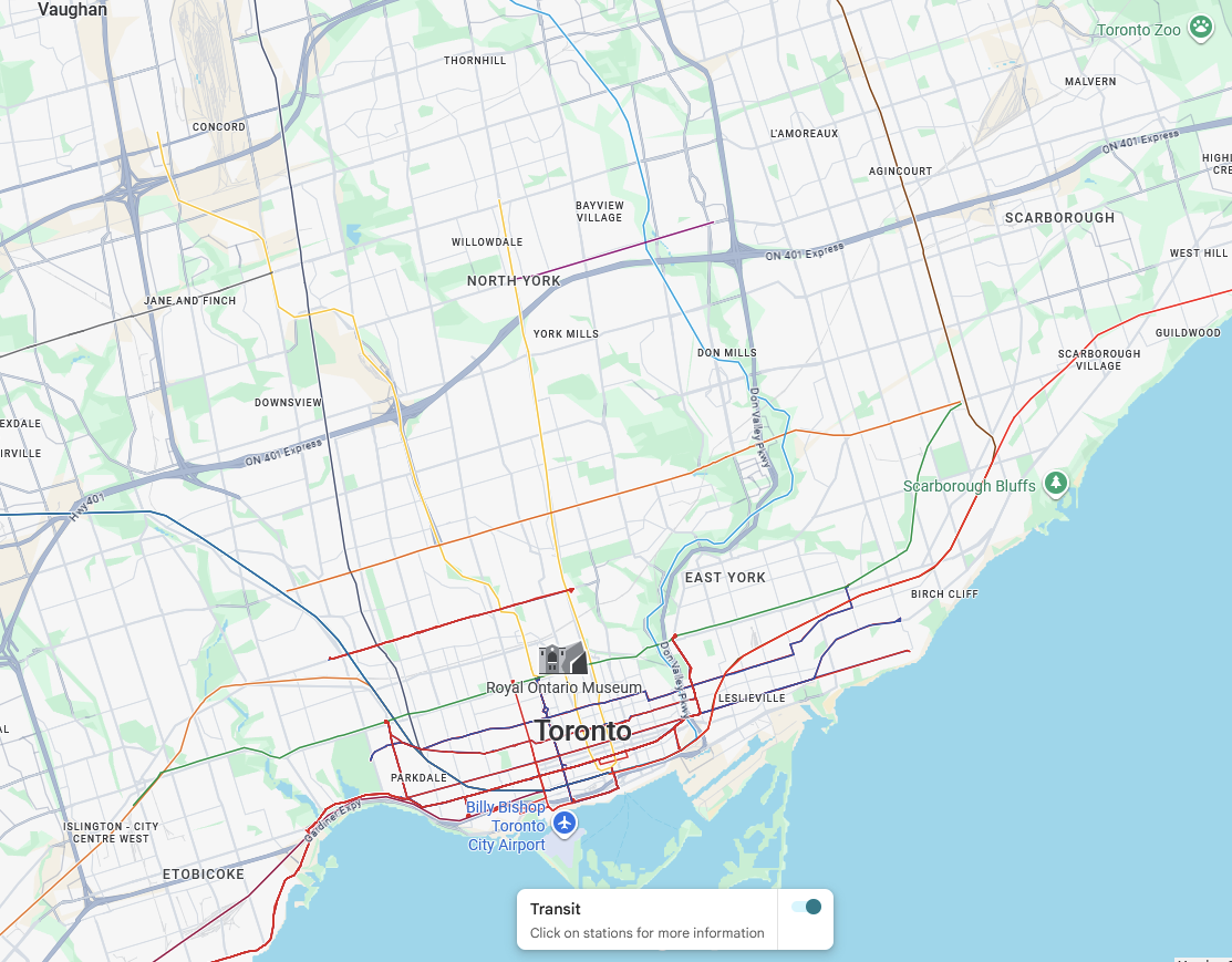
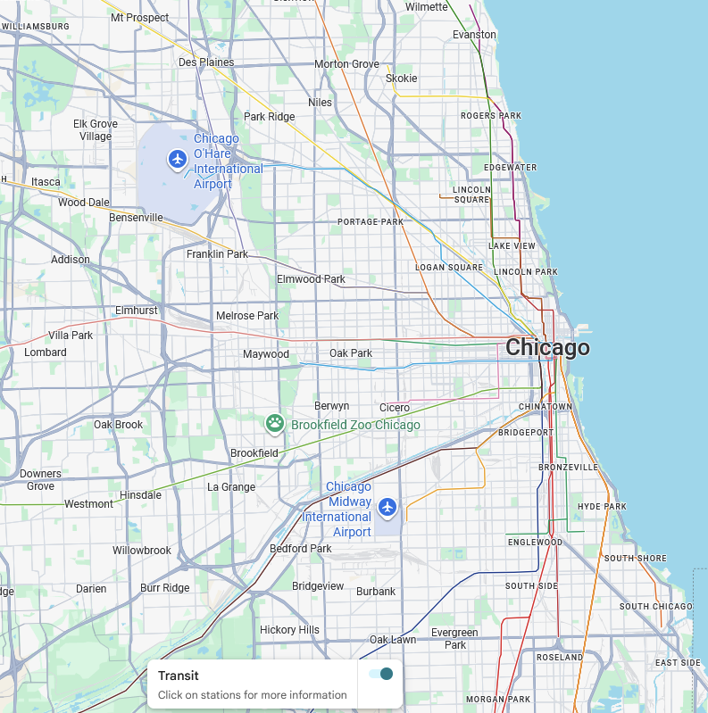
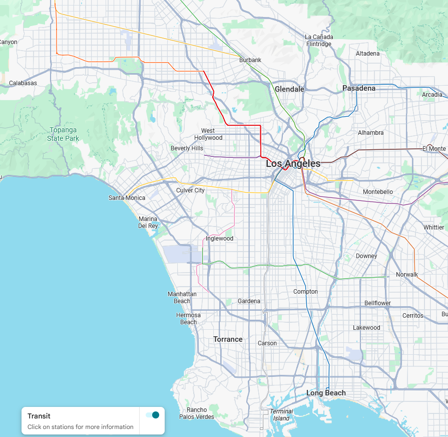
The maps are not all the same scale, but they should make it clear that Chicago and Toronto both have larger and denser rail networks. This does not mean they have rail-dominant ridership: CTA ridership in 2025 was 200 million bus trips and 138 million L trips, and TTC ridership was 193 million bus, 186 million subway, and 35 million streetcar trips. However, the bus networks extensively feed the trains to city center, where mass transit commutes usually are headed to.
In that sense, the bus network in Chicago or Toronto is more similar to that of Boston than to that of Los Angeles. The MBTA bus network is configured almost entirely to feed the subway, since Boston barely has long enough wide streets for continuous bus routes; this is the square system the MBTA inherited from its private predecessors. As a result, subway ridership per metro area capita in Boston is not much less than in Toronto, even though the Boston metro area’s transit modal split for work trips is only 13.4% whereas Toronto’s is 24.7%, both figures pre-corona, there is that little independent bus ridership in Boston.
And yet, the average bus trip in Chicago is virtually identical in length to the average bus trip in Boston: in 2024 the average CTA bus trip was 2.47 miles (3.98 km), whereas that on the MBTA was 2.51 miles (4.04 km); LACMTA had considerably longer average bus trips, 3.44 miles (5.53 km). In effect, the use of CTA buses is to use them to get to the nearest L station, or maybe to the next L line if one is traveling diagonally rather than to the Loop or if the next L line is better for a particular destination. They are operationally lines on a grid for the most part, but from the perspective of passengers, they’re short connector routes that run through. The long north-south routes, the 8 Halsted, 9 Ashland, and 49 Western, are not long from the perspective of their users, and those streets are therefore important cross streets for multiple L lines but are not intended for long-range travel.
In contrast, where the street is intended for long-range travel, people do not do it by bus. They don’t even do it by car. They go on a parallel freeway, because the time cost of driving to the onramp and from the offramp is swamped by the time saving of free-flowing traffic. The main route by car between Downtown Los Angeles and Santa Monica is not Wilshire, but the I-10. Checking on Google right now, at 17:30 local time, gives me an estimated time of 33 minutes from the US Bank Tower to Tongva Park, and 1:13 the other way. Buses on a surface road have no way of competing. Rapid transit can – the E Line, formerly the Expo Line, does it in 59 minutes including walk time at both ends, actually competitive with driving at rush hour in one direction.
What this means is that in a city like Los Angeles, development has no real need to follow the arterial roads the buses run on. If there’s high density at the intersection of main bus routes like Wilshire/Western and Wilshire/Vermont, it’s about preexisting density or about the subway, not about buses. On the freeways, buses can run as well, and quite fast, but the development will never be at pedestrian scale, and the stations are likely to be hostile as well. Even light rail in a freeway median tends to underperform: the C Line, formerly the Green Line, runs largely in the median of the 105, and has 22,000 weekday riders on a 29 km route, which is 28% the ridership per km of the B Line, formerly the Red Line, and around 7.5% of the average ridership per km of the New York City Subway.
In contrast, development can absolutely follow arterial roads if they have subways or if they have buses that connect to subways quickly. Toronto has high-rises on Yonge and single-family houses the next block over due to corridor zoning, but the reason this corridor zoning produces such high density on these arterials (and not just Yonge) is that they’re important to the city’s metropolitan-scale transportation network.
The upshot is that it is never correct to view gridded cities as bus-primary (Jarrett Walker calls subways on such grids, like Yonge, “grid accelerators”). The buses are never primary. They are feeders of a radial rail network, using the grid for efficient planning at the back end, and yet to the passengers the main use is to take the bus a few kilometers to the nearest subway station. The slow speed of buses in large, dense cities, even with extensive prioritization and off-board fare collections, means they’re never competitive with an even vaguely modern road network. Rapid transit can compete, and buses can feed rapid transit to complement the network, but that the street network is a grid doesn’t change the need substantially from dendritic networks in the style of Boston’s square system.


Alon, will you be talking about topography? I believe that a bus grid could work fine for each of the relatively flat valleys + coast of Los Angeles, but the topography is very poor across the metro even if we ignore the issues with no one wanting to take two one+ hour bus rides. I see the maps you posted of Toronto and Chicago and they do not have nearly the same topography issues.
Chicago and Toronto are flat, yeah, but Los Angeles south of the Santa Monica Mountains is flat too; the auto-oriented character of the region didn’t originate in the difficulties of crossing from the main of the Los Angeles Basin to the San Fernando Valley.
First things first: on a metro scale, I would consider ~20% transit mode share to still be auto oriented, unless the micromobility+walk share is sky high (which it is not for these cities). Boston is in the next tier up from Chicago and Toronto, Los Angeles is a tier down.
I roughly measure the following:
Chicago at 30x80km,
Toronto at 50x30km,
Los Angeles coastal plain at 60x30km,
Los Angeles San Fernando Valley at 25x15km,
Los Angeles Pasadena to Ontario at 50x15km
I think a bus grid (or even a BRT grid) makes sense for each of these areas, though obviously proper heavy rail and densification at metro stops is also needed for the reason I stated in my initial post (few people want to commute multiple hours one way, I have known such people on all modes except for walking but they are exceptions).
Boston and Chicago have the same metro transit modal split on pre-corona numbers, about half that of Toronto.
I was looking at the 2024 numbers I could find easily, metro Toronto at 23% / city of Chicago at 21% / Los Angeles 11% / Boston 25.3%, and considering that Boston is in the top 10 for the US while metro Toronto would fall just outside of it. To make it a bit less apples and oranges the 22-23 city of Toronto mode share seems to be 19% probably due to corona.
In terms of boundaries, city of Los Angeles includes far more sprawl than Chicago or Boston, and would probably be close to the overall metro Los Angeles figures.
Metro Boston was 13% pre-corona. Boston has atypically tight boundaries – compare the size of Boston proper with that of Philadelphia proper and then compare their metro areas.
The U.S. Census Bureau gathers all sorts of information. And then …..publishes it!! !! !!
No need to speculate.
The population of the municipality of the City of Los Angeles, according to Wipedia was 3,898,747 at the 2020 census. The population of the County of Los Angeles which in includes many separate municipalities, many which were real estate schemes supported by a trolley car line, and lots of places that aren’t in an incorporated municipality, was 10,014,009. It’s the center of a Metropolitan Statistical Area with a population that was 12,844,441. The Metropolitan Statistical Area is part of a Combined Statistical Area with a population that was 18,316,743. It includes San Bernandino County, the largest county in the country, which stretches allll the way to Nevada border. With lots and lots of uninhabited desert. Much of it parkland that will never have significant population.
Also LA is much bigger physically than these other cities right?
Is it the biggest city physically in the developed world?
In terms of urbanized area, New York is bigger and so is Tokyo.
Maybe this is a better comment for Marco Chitti, but it’s worth noting that most americans have never seen good bus priority. You can have a dedicated lane and have a really slow bus. You can have no dedicated lane and still a decent trip time. It would be good to have some ballpark numbers for what is most time and cost-effective. Obviously there are physical limitations from street transit being at grade, plus heavy cross traffic, but the ways that (for example) light rail lines get bungled by slow sections that are completely avoidable if they were better designed shows a real lack of expertise, and while it may be true that rapid transit will always be faster, it is also true that the relative benefit of overspending on rapid transit is higher with slow buses.
Just to add to my comment, “priority” is really about reducing delay. For a street level alignment, there is an upper bound to speed, call it 50km/h (?), but there is really no lower bound since delays can compound and worsen over time with development or car traffic. Cities that invested heavily in grade separation of one part of a route can completely undo that somewhere else on the route. Cities that invest in aggressive transit priority may only have medium-speed transit, but service and ridership are not lost to blatant inefficiency. It’s still a very worthy investment which expands the usefulness of transit more than a poorly conceived rapid transit line (stations served, operations, or connections)
I think the problem with truly high quality BRT is that the induced demand causes BRT to be insufficient quickly, and by that time you have users expecting the advantages of BRT (branching off of the trunk, already built). E.g. Istanbul Metrobus. Of course, this problem does not apply if the induced demand cannot rise to such a level — that is, if land use prevents it.
In a typical city, most service hours on a bus network are not BRT, they are on local buses. Cities that do transit priority well do it by analyzing opportunity areas on a network level. You get more bang for your buck that way, and yes it is for places that have a slower growing density – but that is a lot of places.
I don’t have high hopes for priority. Generally places where congestion is a problem are places where there is enough demand that you should run a full metro on the same route anyway (or possibly a nearby route?). Where there is not congestion priority can’t really give you much.
Not necessarily. Congestion tied to a given activiry center (school, mall, stadium, employment) often surges for just a few hours or in a specific location, enough to make transit priority useful without huge all-day demand. It makes routes much more reliable regardless of traffic (even random/uncommon events). Also, vehicle patterns can be quite different than main transit routes and transit priority can be an improvement for people whose trip fits the transit network without overserving any particular route. You could also imagine a situation where development is set back from a main road which fills up with traffic but where walking distance land use wouldn’t support a metro. Finally transit competes with cross traffic or turning traffic for light time, generally not same direction traffic (the main exceptions are pull in/pull out conflicts,and parking/delivery). Or from a marginal perspective, saving 3 minutes on a particular route might be the difference that saves a bus for a given frequency, which can be reinvested into the service (there or elsewhere). Rinse and repeat, there are a lot of little delays that add up and metros are expensive.
They’ve done transit priority in London for 20 years.
https://content.tfl.gov.uk/svd-brochure.pdf
And they are still doing it:
https://www.saferhighways.co.uk/post/tfl-to-retime-1-500-traffic-lights-in-bid-to-speed-up-london-buses
You make this all about rail vs not rail. But in theory separated bus lanes could achieve comparable performance; while rail with mixed traffic, close stops, many intersections, and/or sharp curves (any combination of these really) has poor performance.
The Bakerloo line with 50 year old trains is still managing to do Paddington to Waterloo in 14 minutes which is much faster than the 148 bus that does a similar route in 31 minutes or 28 minutes by car on a Sunday afternoon. And the Bakerloo has 9 stops and tight curves over a fairly indirect route over a journey that can be covered in 3.5 miles by foot.
The Bakerloo is grade separated, the buses are not.
No, they actually can’t; on-street separated lanes don’t go at the speed of rapid transit, and the counterexamples you’re thinking about right now are either freeways or things that might as well be freeways.
But you talk about “rail” generally, and your picture of Los Angeles includes rail lines that are not grade separated, and some have slow street-running segments even in the core.
Rail scales up better than a bus. A bus because it can run reuse existing roads (that you are using for like delivering furniture and thus need even in the ideal transit world) scales down much better. Thus rail vs not-rail is really about scale plans. Last mile for anyone who doesn’t live in dense areas is best done on a bus: there is no congestion to worry about and you need frequent stops so you won’t get going very fast anyway. If the bus is getting full run it more often (or if the area is becoming dense replace with rail). In dense areas you need something grade separated to handle the volume (attempts to cheat this need happen all over and fail everybody since they take away already limited space for cars while slowing down transit users) and rail is going to scale better while not costing more.
You can run rail in mixed traffic, but that means you are building and maintaining rails in addition to the road surface, why not just run a bus if this works? You can also run buses on a fully grade separated system, but this is no cheaper than building rails and if the system becomes popular a busway cannot transport as many humans as a track.
The answer to that is in “open bus ways”, or subway/trams – systems that operate in mixed traffic in places, and grade separated elsewhere. They work well in places, but I think they are overused (useful tools, but not my first choice for most transit problems). Make your transfers easy, and then extent your fast frequent grade separated lines as far as possible. The typical system operated this way assumes everybody is going downtown. However there is a lot more to your city – friends who live in a different aware of town for example, and these systems by not prioritizing easy transfers make those other trips really hard – so people end up with a car anyway and once you have a car the marginal cost of additional trips is cheap so you start using it.
I think Paris heavily uses tram-trains now, mixing slower sections with frequent stops and some street running combined with completely grade separated alignment running at 100km/h. This probably suits Paris’ geography better as they have areas of higher density separated by forest/farmland and the transition between suburban and rural is very abrupt. Usually these lines aren’t very long, and in the cases they are, most of the riders only stay on for a short distance to the closest interchange to heavy rail or metro.
It looks like this is what places like Seattle attempted but they failed because the lines are simply too long and not suitable as the main trunk of their system. You need more frequency than what is deemed acceptable for car drivers to endure in the street running section.
In American neighbourhoods where the density is lower as a baseline but is more homogenous this approach probably does not work as well as you end up missing most of the people in a walkable radius but at the same time have to operate at low average speeds. It’s the land use, stupid!
Additionally rail has lower operating costs when you’re running a high frequency, so it is desirable especially in capital-rich countries where operating costs are high but capital costs are lower comparatively (most first-world countries). Therefore it makes more sense to build grade separated rail instead of a frequent grade-separated busway/BRT.
For short sections switching modes is fine. However I quickly become against it because it is robbing time from people who don’t want that other mode. Every person who doesn’t get on/off at a stop/station just got robbed of the time the train needs to slow/accelerate, plus the time lost sitting there waiting for people to get on/off. Thus a transit system needs to focus on getting people where they want to be quick, and this is a compromise with service patterns. If your service pattern is long distances between stops then people will accept a few stops “on the way” but they need to be well spread apart. If your service pattern changes to lots of stops people will get annoyed if they have to lose time at all those places few people are.
Seattle needs to have the high speed commuter lines go to few stations far apart – anyone who wants to go someplace else can get off and transfer to a different slower speed mode where the stops won’t annoy the majority. Traditionally those stations are downtown, but in the US I think it makes sense to have more stations than just that. Those stations should have good transfers to not just local service, but also a faster circumferential line. (it should go without saying that these stations become major centers in their own right since so much traffic points there.)
Henry, has anyone modeled or implemented this express/local tradeoff well? Can you provide examples? I’m new to this space and mostly schooled in communication and information networks and applications of all kind and trying to apply my analog to digital transformation models and frameworks (with a focus on marginal costs and demand elasticity) to transit systems. Much of what you are saying here and elsewhere holds true across the board for any network.
@infostack I’m just a layperson with interest in the subject. It isn’t hard to see the local service always runs slower than express services along routes that have both service patterns, often significantly. It isn’t hard to calculate all the time it takes for a vehicle to stop – deceleration/acceleration time, plus the time with the doors open (in the US the ADA places minimum requirements here, other countries have similar laws), and thus see the real costs.
However I’m not aware of any formal study/model on this. I’m reasonably sure that various people have formally looked at this over the years. I just have no idea who or how to find what they have published. Alon is an academic in the area of transit and they have a much better idea of what has been done over the years.
@Infostack, London and its suburban network would be worth a look, as would Tokyo/Kansai although the top speeds are pretty slow.
In cities like LA, running the buses on the grid means every trip requires a transfer. But when your intersections have 8 lanes, the transfer penalty is quite high. Can take 5 minutes to get from a bus stop on one corner to the one on the diagonal corner thanks to all the dedicated turning movements. And when the bus comes every 20 minutes, you could be looking at a 24 minute wait (assuming no bunching).
Total ridership on LACMTA has fallen continuously since the Blue Line, now the A Line opened in 1990; from 411 million boardings in 1989 to 306 million in 2025. How does one reconcile this hard fact with the statement, “but the rail must come first.”
Ridership out of poverty in the 1980s was still ridership. Other places built better rail networks and ended up with decent modal splits even in some fast-growing regions like Vancouver.