Category: Regional Rail
What Happened to the RPA?
Last month, New York’s Regional Plan Association published a report, Overlooked Boroughs, proposing various transit improvements in New York outside the Manhattan core to complement the existing Manhattan-centric subway network. I’ve been thinking for a while what to say about the report. I don’t want to mock too much, since the RPA clearly tries to improve things. But the report falls short in every way, and plays into fads about buses. The one point of light is a brief mention of subways under Utica and Nostrand Avenues, but it is vague and doesn’t even make any of the maps the RPA is producing for additional rail and bus service. Even the RPA’s positive past contribution to the region’s transit proposals, Triboro RX, is replaced by the inferior Crossboro system. All this is on top of wooden analysis of preexisting transportation options.
The Analysis
The technical report talks about low transit usage for travel within the Outer Boroughs, which for the study’s purposes include Upper Manhattan. Figure 3 on page 7 breaks down mode choice as transit versus other modes. This works in Queens, but in Upper Manhattan and the South Bronx, car ownership rates are so low that local transit is competing with walking (and biking). In the Bronx in general, the mode share for borough-internal commutes is 40% transit and 36% car; in Brooklyn, the corresponding numbers are 42% and 32%. Eyeballing figure 3, Upper Manhattan’s transit share looks like 35%, but the car share is almost certainly much lower, given very low car ownership. This means there’s a huge volume of non-mechanized transportation in those regions.
The study does mention expanding bike infrastructure, on pp. 50-51, with an emphasis on bike share. However, its conclusion is directly at odds with the fact that non-mechanized transportation is quite popular in Upper Manhattan, the Bronx, and Brooklyn. It calls for incremental enlargement of the current system’s coverage, which consists of Manhattan south of 59th Street and the innermost parts of Brooklyn. It specifically warns against rapid expansion, “so as not to spread the program too thin,” and says the next areas for coverage should be the bridge landings in Brooklyn and Queens and the Upper East and West Sides. Inexplicably, low-income Bedford-Stuyvesant, which is adjacent to the current coverage area, is explicitly listed as a future phase and not a current priority.
A better proposal would call for rapid expansion of bike share and bike lanes; this costs money, but so does transit. Moreover, since the neighborhoods that would gain the most are low-income, the city should give some thought to how to make its bike share system easier to use for low-income residents. The current system requires a debit or credit card and puts a $101 security hold per pass. A city-subsidized system allowing qualified low-income residents to ride without a security hold is required; for example, the city could allow EBT cards to be used in lieu of a security hold, even if their holders then need to put in cash or a MetroCard to pay, in case the federal government disallows using the cards for biking and not just food stamps.
Then, a few pages after the analysis of intra-borough commutes, the report makes another mistake: on table 2, it lists mode shares for commutes between city boroughs and suburban counties, as well as likely transit options. Where commuter rail exists, it lists it as an option: thus, the Manhattan, Queens, or Brooklyn to Essex County rows list “subway to New Jersey Transit” as an option, despite the fact that New Jersey Transit is expensive and infrequent in the reverse-peak direction. Most likely, transit commuters from New York to Essex County work in or near Downtown Newark and take PATH, or at the airport and take a bus.
Now, the report does talk about commuter rail’s deficiency in attracting urban riders, both in the discussion surrounding tables 2 and 3 and in the proposal to improve commuter rail on pp. 49-50. But it says little about frequency for reverse commuting. Even when it does acknowledge the LIRR’s one-way peak service, it pulls its punches and only says it “recommends this project” (three-tracking the LIRR Main Line); proposing to instead do away with peak express service in order to permit reverse-peak service on the other track – as is practiced on the two-track segments of the Chuo Line – is beyond its scope. The punch-pulling is significant; as we will see over and over, the report repeatedly lets itself be defined by current practices and low-level current proposals.
Finally, the analysis of buses leaves something to be desired. The report talks at length about issues regarding span, frequency, and speed, on the list of nine characteristics that determine the attractiveness of transit. There’s no attempt to look systematically at what the busiest bus corridors in the city are. At some places, the corridors proposed match those of busy bus routes, for example the main crosstown routes in Brooklyn, the B35 and B6. At others, they neglect them entirely: as Alexander Rapp noted in comments recently, Grand Concourse, hosting the Bx1/2, is one of the busiest bus corridors in the city, even though it parallels the subway – it’s busier than Nostrand, which is now a Select Bus Service (SBS) route. The third busiest Bronx route, the Bx19, running on Southern to 145th in Manhattan, is also neglected.
We Just Call It “The Bus”
I think it’s Zoltána who said that what Americans call bus rapid transit, Londoners call “the bus.” As she noted in the past, three-door buses with all-door boarding are ubiquitous in Italy. German-speaking cities tend toward all-door boarding as well, as does Paris, but the buses usually have just two doors. All of this is years-old discussion, here and on related blogs such as Human Transit.
The significance of this is that it throws a wrench in any and all attempts to plan surface transit in New York around SBS, which is a bundle of features: enforced off-board fare payment, longer stop spacing, dedicated (but not physically separated) bus lanes. Vancouver engages in similar bundling with the B-Lines, but at least gets it right by not enforcing off-board fare payment: there are no machines printing tickets at any B-Line bus stop, but instead passengers can pay the driver at the front, or board from any door if they have a monthly pass or a transfer slip, which most do. But even Vancouver makes a mistake by requiring everyone to board from the front and pay the driver on all but a handful of bus lines. Vancouver, at least, establishes B-Line routes to mark where it considers building SkyTrain extensions in the future. In New York, it’s not about subway extensions; the planners really do think these features are special, and should be combined.
The RPA could have pushed for citywide off-board fare collection. Instead, it chose to smother any such push:
Set up off-vehicle fare payment using a proof of payment system. Passengers will not only board faster, but they will also be able to board using either front or back doors. However, the high cost of this option makes it impractical for system-wide implementation. Alternatively, the MTA should shift to touch or vicinity passes, the successor to the MetroCard, which is fast becoming obsolete.
First, the invocation of high cost in any plan that includes subway extensions, as this report does, is laughable. One-word replies to this point include any city where all buses already use proof of payment (POP), such as Paris, Berlin, Zurich, or Singapore. This is especially true now that the front end of smartcard technology is so cheap that there are top-up consumer items sold for $30. The cost of putting a card reader at every bus stop and at every bus door is, in 2015, trivial; what is not trivial is the cost of paying drivers to idle while bus riders are dipping their MetroCards at the front one by one.
If we accept citywide POP and bus stop consolidation – again looking at practices in Europe (and in Singapore), bus stops here are spaced every 400 meters and not 200-250 as in the US – then the rationale for SBS breaks down completely. All that’s left is corridors that require bus lanes, and those do not need to be continuous, as a bus can run partly on dedicated lanes and partly in mixed traffic.
Planning for the best corridors for specially upgraded surface transit requires thinking in terms of key bus corridors; the report does this because it assumes SBS is special, and the discussion with Alexander Rapp about Grand Concourse was about light rail. But if this is really just about bus lanes, then planning should be in terms of street segments. Bus lanes are required whenever there are busy buses on congested streets, and feasible when the streets are wide enough to permit car lanes and parking lanes in addition to the bus lanes. The importance of congestion means that a citywide bus lane map would be much more Manhattan-centric: potentially all Manhattan avenues and most two-way streets should have bus lanes since Manhattan traffic is so slow, even if there are key corridors elsewhere in the city with higher ridership.
At this point it’s useful to step back and think about relative advantages of surface transit (in this case buses) and rapid transit. Surface transit will always be slower, more expensive to operate, and far cheaper to deploy than rapid transit. This is why bus maps look like dense grids or meshes in every major city whereas subway maps only do in a small number of megacities.
The upshot is that there’s less need to force buses into a few key corridors. If New York were to build a subway or even light rail on a corridor, it would have to choose the routing in a way that would replace multiple parallel buses. For example, light rail on Tremont would replace both the Bx40/42 and the Bx36, which run on or parallel to Tremont in different parts of the Bronx. There’s no need to do that with bus-based transit: the Bx40/42 and the Bx36 can stay where they are. Route consolidation is only beneficial insofar as it boosts frequency, which means it’s required on minor routes but optional on major ones – this is why there’s a bus on every Manhattan avenue except Park, with no consolidation of the various one-way avenue pairs. The Bx40/42 runs every 10 minutes in the midday off-peak, and the Bx36 runs every 7-8 minutes, so there’s no need for a combined corridor.
Another key difference, ignored in the report, is that surface transit needs to run on straight, continuous streets whenever possible. Turns slow the bus down much more than they slow the subway (although they do increase the subway’s construction costs, since the subway would need to go under private property). This is partly because the bus is already slower, so the extra travel distance is more onerous, and partly because turning from one street to another requires red-light cycles that may not be easily eliminated via signal priority.
One upshot of this is that the report’s proposed bus map has some routes that are completely insane. Figure 14, on page 40, has two proposed new SBS routes in the Bronx: one paralleling the Bx36 and Bx40/42 in a circuitous manner, and going north-south in the East Bronx with several jogs and turns larger than 180 degrees. Nobody needs such circuitous routes.
Another upshot is the situation in Brooklyn. Brooklyn has five of the city’s top ten routes: the crosstown B35 and B6, and the radial B41 (Flatbush), B44 (Nostrand), and B46 (Utica). The latter three follow their streets nearly the entire way. The first two do not, as Brooklyn does not have continuously important crosstown arterial streets the way it has Flatbush, Nostrand, and Utica. Now, to be fair, the B6 is as fast as the three radials, all averaging 11 km/h on local buses and 12-13 on limited ones, but the B35 is much slower, 8 km/h local and 9 km/h limited; all average speeds are computed departing eastbound or northbound at noon. Between this and the B6’s somewhat zigzaggy route, the circumferentials are slowed more than the radials, which means rapid transit becomes more useful.
Enter Triboro RX, which appears in modified form (see below) in the report. Although it doesn’t closely parallel the B35 or B6, it provides a similar kind of service, and could poach significant ridership from both. This means that the introduction of rapid transit service there would make it less important to upgrade the B35 and B6 beyond the upgrades all other buses receive; conversely, such service would get much more ridership than we see today on buses, since it would offer such a large speed benefit. Of course the same is true of subway extension on Nostrand and Utica, but the rail bias over the existing 12-13 km/h options is a bit less than over a 9 km/h option; it’s only the easy tie-in to the 2, 3, 4, and 5 trains and the very high ridership of three closely parallel bus routes that make two subway lines pencil out.
Unfortunately, there’s no attempt at combined planning in the report. There’s no attempt to tie upgraded bus routes in Brooklyn and Queens to new transfer points created by Triboro. At the city’s other end, in the Bronx, Second Avenue Subway Phase 2 would make an East 125th Street terminus desirable for some Bronx buses; this is again not shown. Figure 14 on page 40 doesn’t show subway extensions, and figure 15 on page 44 doesn’t show SBS routes.
Finally, one notable inclusion is that of North Shore Branch SBS. Everything I could say about this I said three and a half years ago; it’s a terrible plan, and the fact that the RPA is going through with it instead of explaining why a second Staten Island Railway line would be better speaks volumes to how little the RPA is willing to come up with its own ideas instead of following whatever fads the city and MTA engage in.
Rail: Even When It’s Right, It’s Wrong
The report’s proposals for subway and commuter rail expansion have good kernels, but manage to make big mistakes on top of them, producing projects of limited transportation value. Here the RPA’s mistake is less overrelying on bad government planning (there is none as far as rail is concerned) and more overrelying on its own hype and that of similar organizations.
The plan for Second Avenue Subway is still in place. However, one key proposal regarding phasing worries me:
There is a strong argument to move quickly to build the north segment first as far as 116th Street, which would be relatively inexpensive since much of the tunnel is in place from earlier work, leaving the more expensive last piece to 125th Street for later. This report supports this argument.
Although in East Harlem, 116th Street is the key throughfare, a connection to 125th Street is crucial, for the transfer to Metro-North and the 4, 5, and 6 trains. It’s not even too much more expensive than a Phase 1.5 to 116th Street, since the 106th and 116th Street stations would still need to be dug, and the stations are the dominant part of Second Avenue Subway’s cost, three quarters of Phase 1 if I remember correctly.
Moreover, the report suggests various tie-ins, all on page 43: going west across 125th, going north into the Bronx, going south to Brooklyn via a new tunnel and taking over the Atlantic Branch of the LIRR. The first one would be golden, but isn’t even depicted on the associated map, figure 15 on page 44. As with the Nostrand and Utica subways discussed on the same page, the best ideas in the report are presented as afterthoughts and not depicted on any map. The Bronx extensions are harmless, but the routes shown on figure 15 are at times circuitous. The Atlantic Branch plan, fortunately not shown either, is the worst: the Atlantic Branch should be part of a modernized commuter rail plan. Despite the fact that the report does talk about commuter rail upgrades, it still considers cannibalizing a key route for a Second Avenue Subway extension.
The second key piece of rail infrastructure proposed, Triboro RX, is the RPA’s key contribution, dating back to 1996. Michael Frumin worked on this project and, together with Jeff Zupan, one of this report’s two authors, estimated its ridership at 76,000 commuters, each taking a roundtrip per weekday, for about 150,000 weekday boardings. Unfortunately, this report scraps many of the useful features of Triboro, replacing the line with Penn Design’s inferior Crossboro, which runs alongside the Northeast Corridor in the Bronx instead of completing the semicircle around Manhattan.
Moreover, for reasons I do not understand, the report widens the interstations on Triboro. The original plan called for a station every 800 meters, excluding the Hell Gate Bridge; including it, there would be about a station every kilometer. The current version of the route has a station every 1.8 km; even excluding the Bronx and Hell Gate portions, this is a station every 1.6 km. Broadway Junction, a key transfer point with connections to the A, C, and J, is deleted; trains run nonstop from New Utrecht to the Brooklyn Army Terminal; successive spokes in Brooklyn get no stations between them, even when the distance between the radial lines is such that most subway networks would put in a station in the middle.
Finally, commuter rail modernization falls flat. The RPA correctly calls for lower fares and higher off-peak frequencies – but then fails to follow through with demanding reductions in marginal operating costs. A discussion of high off-peak frequency and subway-competitive fares is a waste of time if each train is staffed with five conductors. A more reasonable number of conductors, zero, is required for this to financially pencil out.
But even if we ignore the costs, the plan does not look like a plan with modernized commuter rail. There are no infill stations proposed. High frequencies and mode-neutral fares would make Astoria a desirable commuter rail stop; but the stations mentioned on pp. 49-50 for Penn Station Access service are only the ones currently proposed in the Bronx, omitting Astoria. Similarly, despite wild plans, not depicted on maps, to construct a commuter rail branch on Utica, there’s no mention of simply adding a Utica stop to Atlantic Branch trains. Nobody is going to use Utica or Astoria for today’s fares or on today’s schedules, but frequent, cheap commuter rail service to these areas would be very popular.
All of the ideas proposed for rail are good, in principle. I’m glad that Second Avenue Subway is receiving priority, that Triboro is on this map, and that there’s talk of commuter rail modernization. But every when the RPA gets it right, it wrecks things with bad details about phasing, station placement, and lack of consideration of what commuter rail modernization would do to demand patterns.
Where are the Forward-Thinking Proposals?
The report simply cobbles together various proposals by organizations and politicians, without trying to turn them into a coherent whole: some bus upgrades here, some subway and commuter rail expansions there, no real attempt to even make the various modes work together. Even within each tranche, the report often rehashes current city plans, no matter how inappropriate.
Is the RPA thinking forward here? I don’t see any evidence of forward thought in the report. Where Paris is beginning construction on 200 kilometers of driverless rapid transit, mostly underground, the RPA is proposing 10 km of subway in future Second Avenue Subway phases and 40 km of rapid transit on existing right-of-way in Triboro RX. If New York could build subways at Paris’s prices, about $250 million per kilometer, Ile-de-France’s budget for Grand Paris Express, about $35 billion, would build the entirety of Second Avenue Subway eleven times over. There would be money for multiple radial and crosstown subway extensions and commuter rail tunnels (at Parisian costs, my commuter rail through-running tunnels would together be $20 billion or somewhat less); bus upgrades, done right, would show as a rounding error in streetscaping, and actually save money since higher speeds would reduce operating costs.
The Third Regional Plan did talk about things that other people were not proposing at the time. It had more Second Avenue Subway tie-ins, for one. Here all the RPA is doing is slapping its logo on a bad bus upgrade plan and reminding people that there’s a Second Avenue Subway project waiting to be finished. What happened to the RPA?
The Wrong Kind of Branching
Transit lines branch. Core routes have more demand than outlying ones, so naturally trains and buses run on trunk lines in the core and then branch farther out, to match frequency to demand. I gave an overview of this years ago. This is both normal across nearly all significant transit systems, and good practice. In this post, I’d like to focus on the opposite kind of branching, which I am going to call reverse branching, when one outlying line splits into two core routes. This is much less common, but exists in multiple cities, and leads to problems including restrictions on capacity and disappointing ridership. Cities should avoid building new lines that reverse branch, and in one famous existing case, London’s Northern line, the city is working on changing the situation by building a new outlying branch.
London’s Northern line, as can be seen on the Underground map, has three branches to the north and two in the center, but just one to the south. The highest ridership demand is in the center, but because both branches feed into just one southern branch, there is less than full capacity on the central branches, about 20 trains per hour each, compared with 30 tph on the southern branch and 33 tph on the Victoria and Jubilee lines. As a result, Transport for London has made recurrent plans to split the line for good: one central branch (through the City of London) using the existing southern branch and two of the northern ones, and one (through Charing Cross) using one northern branch and terminating at Kennington, the junction with the southern branch. An under-construction extension of the line from Kennington to Battersea can then be tied to the Charing Cross branch. There is some NIMBY opposition from a member of Parliament representing a constituency on one of the northern branches, who would like her constituents to have one-seat rides to both branches, but most likely, Transport for London’s need for capacity will make the split inevitable once the Battersea extension opens, ending the reverse branching practice.
In New York, routes branch and recombine, and thus it is common to have trains of different colors (which only denote Manhattan trunks) running together on a branch in Brooklyn, Queens, or the Bronx. The single busiest entry point into the Manhattan core is via 53rd Street Tunnel (connecting to Queens Boulevard), technically a branch since it runs trains connecting to both the Eighth and Sixth Avenue Lines. This, again, causes capacity problems. It’s not so bad on the numbered lines, where four trunk tracks (the Manhattan express trunks, carrying the 2/3 and 4/5) recombine in a different way to four tracks in Brooklyn (pairing the 2/5), but the lettered lines’ reverse branching in Uptown Manhattan and Queens initially forced eight trunk tracks (the Sixth and Eighth Avenue services, the B/D/F and A/C/E) to converge to six branch tracks (the two Queens Boulevard express tracks via 53rd, and the four Central Park West tracks). New subway connections have replaced this situation with twelve trunk tracks (including the Broadway Line’s N/Q/R) splitting to ten, spreading the problem around but not dealing with the fundamental restriction on capacity. The under-construction Second Avenue Subway will connect to the Broadway Line and run Q trains, raising the number of lettered tracks Uptown and in Queens to twelve, but this will not be enough to disentangle the tracks and provide full capacity on each core track; see below for proposed examples.
In Delhi, the Green Line splits into short branches, to provide transfers to two different Metro trunk lines. As seen on the system map, the Green Line does not enter central Delhi, and the current setup allows passengers to travel to central Delhi via two different routes. However, the Phase 4 extension plan extends the one branch to go out of the city in a V-shaped direction (the light green Kirti Nagar-Dwarka Section 28 line on this map), and has an extension that may connect to the other branch (Inderlok-Indraprastha, colored ocher on the map) to connect it to central Delhi, which may cause a serious mismatch in demand on the outlying common segment.
Finally, in Tokyo, subway lines reverse branch in two locations. The Namboku and Mita Lines share their southernmost three stations and the tracks in between. Although most Tokyo subway lines, including Namboku and Mita, run through to commuter lines, which provide the normal kind of branching, the Mita and Namboku Lines only do so either to the north or via the shared segment, as seen on this map, constraining capacity. They run only 12 peak tph each, and have low ridership by Tokyo subway standards. The Fukutoshin and Yurakucho Lines are in a similar situation, but the Fukutoshin Line does run through to a commuter line, the Tobu Tojo Line, without going through the shared segment (it is not depicted on the map, which is a few years out of date). The Fukutoshin Line has low ridership (see last page here), but the Yurakucho Line does not.
In all examples I’ve listed so far, the two core branches serve very central areas (as in London, New York, and Tokyo), or neither of them does (as in Delhi). Tokyo is somewhat of an exception, since the Yurakucho and Mita Lines serve Central Tokyo and the Fukutoshin and Namboku Lines serve secondary centers, but those secondary centers are very dense themselves; the Mita and Namboku Lines in particular are quite close in ridership. I am more wary of proposals to split an outlying line in the core that have one branch serving the CBD and one branch avoiding it, as in Delhi, assuming I understand the proposal correctly.
Also of note, all the examples I’ve listed involve subways. This is because conventional branching, with a core trunk splitting into multiple outlying branches, is more limited on urban rail than on both buses and regional rail. Most subway lines do not have more than two branches feeding into a trunk. In New York, not counting the split in the A, which is inherited from the LIRR, there is exactly one place where three subway routes share tracks: the N, Q, and R from Manhattan to Queens. In Stockholm, with its highly branched subway network, only one line, in one direction, splits into three. This is because even a split into three branches requires limiting off-peak frequency on the branches to less than a train every ten minutes, which is undesirable in large subway systems. The result is that reverse branching can easily create a situation in which there are more tracks in the core than in the outlying areas, as it does in all four cities surveyed above, restricting capacity on each core track.
In contrast, regional rail tends to operate at lower frequency on the branches, and this permits conventional branching with more than two branches per trunk. In addition, there are often turnback facilities at through-stations, and substantial four-track segments on otherwise two-track lines. The result is that reverse branching is possible without any constraint on core track capacity. The Berlin S-Bahn is highly branched in both the conventional and reverse senses. The RER E is being extended to the west, including a takeover of an RER A branch. And the Tokyo commuter rail network has extensive reverse branching, coming from through-service between commuter lines and subway lines but also from the Shonan-Shinjuku Line’s split from the Tokaido and Tohoku commuter lines. In none of these cases is there a significant restriction on core capacity, simply because there’s enough slack in the branches that they can’t fill to track capacity unless the core has filled as well.
In the US, I am familiar with three proposals for new subway lines that involve reverse splits, in Boston, Washington, and New York.
In Boston, the proposal actually involves commuter rail rather than the subway: the Worcester Line would use the Grand Junction Railroad to go through Cambridge to reach North Station, bypassing South Station. See map on page 38 of the statewide transportation capital budget proposal. This would not reduce capacity, since the Worcester Line is nowhere near exhausting the capacity of a two-track railroad, and moreover, the Grand Junction line would terminate at West Station within Boston proper, where there’s a railyard. However, this is still bad transit, for other reasons. West Station serves a residential neighborhood, without enough density to justify a fork toward both North Station and South Station. On top of that, since North Station lies outside the Boston CBD, the proposal is essentially a mixture of a radial and a circumferential line, with all the problems that would bring – and despite running as a circumferential line through Cambridge, there is no transfer planned with the Red Line, although the Grand Junction passes close to the Kendall/MIT station.
It would be better to bag all plans to use the Grand Junction until such time that the state builds the North-South Rail Link, connecting North Station with South Station. Then, the Grand Junction would make an almost perfect alignment for a circular line, with its eastern leg connecting North and South Stations and its western end going through Cambridge, making several stops, including a transfer to Kendall/MIT. This would require high investment – besides being a single-track at-grade line, the Grand Junction would require a new junction to connect to the Worcester Line to go east toward South Station, whereas today it only connects to the west, toward Allston and Brighton – but still a fraction of the cost of the North-South Rail Link, which is getting some serious political support, including from former governors Michael Dukakis and William Weld.
In Washington, there already is some reverse branching: the Yellow and Blue Lines share tracks in Virginia, but run on two different trunk lines in Washington proper, each shared with other lines, so four central tracks become four tracks in Virginia. But now with the opening of the Silver Line, raising the number of Virginia tracks to six, WMATA would like to separate the Blue Line from the Orange Line, which it shares tracks with in Washington, in order to provide six tracks across the District as well. This can only lead to awkward service patterns and wasted core capacity, as Matt Johnson demonstrates on Greater Greater Washington: because the Orange and Silver Line will keep interlining under any plan, reckoned from their split east there are only four tracks in Virginia and not six. Moreover, the Yellow Line interlines with the Green Line in the District, which means that even if it’s separated from the Blue Line, it could not run at full capacity.
Washington built itself into a corner with its Metro route decisions. There’s no corridor in the city that really needs a subway line; unlike New York, Los Angeles, and San Francisco, Washington has no corridor with so much bus ridership that it should be a subway line. A fourth subway line would be useful for service to Georgetown, but that’s about it. So decisions about a fourth line in the District should be based on the capacity needs of the branches, not those of the core. On a list of possible changes that WMATA looked at, Greater Greater Washington included a separated Silver Line, including separation up to the junction with the Orange Line so that they share no tracks. I’ll add that if WMATA wants to go down that route, then it should give the Orange Line its own route through the District and keep the Silver and Blue Lines together; this is because the Orange Line is the busiest of the three, so that it should be the least branched, in this case not branched at all whereas the other two do branch.
Finally, New York. Second Avenue Subway is going to change the nature of the reverse branching used by the lettered lines, for the better. Because the plan for Phases 1 and 2 is to run only the Q train, the city will finally have matching numbers of lettered tracks in and north and east of the Manhattan core: twelve tracks in the core, and twelve in Uptown Manhattan and Queens. Unfortunately, it is impossible to match service, because that would sever too many connections. Second Avenue Subway only connects to the Broadway express line, so to match service there couldn’t be any other service using the Broadway express.
Recall the London NIMBYism mentioned at the beginning of this post: that was about a service change that would give commuters a cross-platform (see comment with diagram) transfer between their branch of the Northern Line and the central segment of the other branch. In New York, the transfers in western Queens involve a lot of walking between platforms, if they even exist. Then all the Broadway locals (the N/R) would go to Queens through 60th Street Tunnel, and thence to the Astoria Line, severing the connection to the Queens Boulevard Line. The Queens Boulevard Line has two ways into Manhattan: 53rd Street, which connects to both Eighth and Sixth Avenues, and 63rd Street, which connects only to Sixth Avenue. Moreover, either all F trains (through 63rd) have to run express in Queens and all E trains local, or the reverse; mixing and matching would produce at-grade conflict at the junction, as seen on the Queens 1 track map on nycsubway.org. The transfer between the E and F would be located at 74th Street in Queens, several kilometers east of the split, which is located just to the east of the westernmost express/local station, Queens Plaza. Neither the E nor the F would have a transfer to the N/R near their respective intersection points. The Q would not have a transfer to the E (it would have one to the F, though). This puts many commuters in an impossible situation and the capacity gains from it are frankly not enough to be worth it.
Instead, the capacity gains would be limited to running some more express trains on the Broadway Line. Before the service cuts in 2010, the N ran express on the Broadway Line, the Q terminated at 57th Street at the north end of Midtown, and a fourth Broadway route, the W, ran local and served the Astoria Line. Once the Q is extended up Second Avenue, the restored W could beef up Broadway Line service. Second Avenue would only get a branch despite its high ridership, but it’s still only a segment of a line.
Then there are Phases 3 and 4 of Second Avenue Subway, serving Midtown and the Lower East Side, where the Q runs on Broadway. The official plan introduces another reverse branching: a new route, the T, is planned to run the entire length of Second Avenue: see map here. When both phases are complete, there will be fourteen lettered tracks in Midtown but only twelve Uptown and in Queens.
To resolve this, the MTA should activate a connection that is included in the Second Avenue Subway plan as a non-revenue connection: a connection from Second Avenue south of the Q/T split at 63rd Street to 63rd Street Tunnel; currently, 63rd Street is the least used connection from Manhattan to Queens, since the reverse branching limits capacity and 63rd Street is the least useful connection since it enters Manhattan north of Midtown. This implies there should be a Queens Boulevard-Second Avenue service, which I will call the U, one letter next to the T. The Queens Boulevard express tracks are filled to capacity and the local ones are not, so the T should run local, cutting the frequencies on the existing local R and M trains a bit to make room. It would still leave New York with twelve Uptown and Queens tracks diverging to fourteen Midtown tracks, but it would distribute the load better, in the same way the present system distributes the load better than the 1930s-era reverse branching from six to eight tracks did.
New York is in a somewhat special case, in that its subway system is based on heavy branching and reverse branching, and moreover it’s historically based on three different systems, with poor transfers between them. Fully untangling the lines after Second Avenue Subway’s Phases 1 and 2 are built is not possible because there are no transfers between the lines that would result, and the station placement is such that any new transfers would involve long walks between platforms.
Other cities, especially cities planning new systems from scratch, should not emulate this feature, and should instead design all lines to either not branch at all or only branch conventionally. A system designed from the ground up could have cross-platform transfers between lines, and even make sure they’re timed, reducing the cost to passengers of having to transfer in lieu of using a reverse branch. It could be coherent, in the sense of making it easy for an unfamiliar passenger to understand how to get from each station to each other station. And it could be built for maximum capacity in the most crowded segments, where it matters the most.
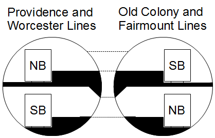
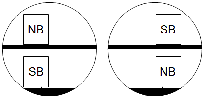
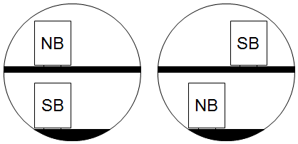
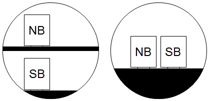
North-South Rail Link Diagram
In my post about large-diameter TBMs, I proposed using them to bore Boston’s North-South Rail Link. Like the official plan, this calls for two pairs of tracks, one feeding Back Bay and thence the Providence and Worcester Line and the other feeding the Fairmount and Old Colony Lines. Since there are three sites for stations – South Station, Aquarium (for the Blue Line connection and the north end of the downtown office cluster), and North Station – this calls for a design in which the middle station has right-way cross-platform transfers, and the two end stations have wrong-way cross-platform transfers. Here’s a diagram, consisting of half this arrangement. Top end denotes either North Station or South Station, bottom end denotes Aquarium.

The assumed bore diameter is 12 meters, which corresponds to 1 meter = 16 pixels. The dashed lines are galleries punched at regular intervals into the two bores, connecting the platforms at stations. The assumed operating speed is 90 km/h; this requires a curve radius somewhat higher than 300 meters, about the lowest that can be achieved beneath the Central Artery, assuming no underground surprises.
Moving one track aside, as done between the second and third image and between the fifth and the sixth, requires 3.4 meters of lateral displacement, which at this speed is almost all curve spiral rather than full curve, encouraging using a higher curve radius and shorter spirals. Near the lower limit of the curve radius that permits 90 km/h, the spirals would be longer than the curve itself. With a 1,000-meter curve the track would do the transition in 118 meters. Switching the heights of the tracks, as done between the third and fifth images, requires 5.5 meters of vertical displacement (possibly a bit more, depending on catenary clearances, but certainly not more than 6 meters); I can’t find information about vertical curve radius at low speed, but if the same vertical acceleration as at high speed works, then using Swedish standards, 1,300 meters works, in which case, with EMU-friendly 4% grades, the transition requires 190 meters. 118+190+118 = 426, less than the distance between each pair of stations, if not by the most comfortable of margins.
The advantage of this configuration is that people making diagonal trips, such as between Framingham and Braintree, could transfer cross-platform at South Station. With two stations, as is the case in Singapore for the transfers between the North-South Line and East-West Line, passengers on one of the wrong-way pairs would need to travel one station farther than they have to on each line; with three, passengers between two points on lines north of Boston feeding two different tubes, for example Salem and Waltham, could transfer cross-platform at North Station.
Finally, the reason for two tubes rather than one is that it makes the portals simpler, especially at the southern end. I discussed above the transitions between different configurations of tracks inside the tube, but the transitions from an at-grade two-track line to a two-track tube with one track above the other require more vertical displacement, and this favors two separate portals to the south, one pointing at Back Bay and one pointing due south toward Fairmount and the Old Colony Lines. Merging the two bores underground is possible, but the cost differential with just doing two bores all the way may not be enough to justify the reduction in capacity.
Who Rides Commuter Rail?
I’ve had an argument in comments with the author of Purple City about who commuter rail should serve. He’s argued before that cities should make sure outer suburbanites can get to the center via express commuter rail, and I will add that American cities do do that, and orient commuter rail too much around the needs of peak-hour outer suburbanites. Insofar as I think cities should have commuter rail there’s no disagreement, but what I think they do wrong is focusing too much on the peak. The two practices in contention are the low off-peak frequency (for example, Metra’s Union Pacific-North Line, which has no freight to speak of, has worse than hourly off-peak service), and the stop distribution, which has trains making few or no stops in the city proper.
The common thread of these two practices is that they optimize one variable: peak travel time for a suburban commuter to the CBD. This neglects other sources of ridership on commuter rail, which are suppressed in the US but significant in countries with more modern operating practices. I will contrast the peak-focused approach with a rapid transit approach, using examples that I believe will show that the latter is bound to get far more ridership, even in the suburbs.
First, let us imagine a contrasting system, one in which North American commuter rail looks more like an RER, an S-Bahn, or a Japanese commuter rail network. Such a system will have the following features:
1. Relatively consistent stopping pattern. The busier lines may have local and express trains, but the express trains will stop at the same major stops. Local trains will make all local stops over a fairly wide stretch.
2. Low ratio of peak to off-peak frequency, in the vicinity of 2:1 or even less. In a major city like Chicago or New York, a line that can’t support half-hourly service all day, at a bare minimum, will likely have no service at all; the only exceptions I can think of are services at range so long they’re practically intercity, like New York-Hamptons or New York-Allentown.
3. An urban stopping pattern that’s not too express. If there’s a parallel subway then it’s okay to have a somewhat wider stop spacing than in the inner suburbs beyond the subway’s range, but still closer to the 2-3 km range than the 4-5 km range of Metra.
If it’s possible to do so technologically, then the commuter line may be interlined with a subway line, even. This is usually hypothetical, since subways and commuter trains, where both exist, are almost always technologically incompatible; Tokyo and Seoul are the two major exceptions, with London a borderline case. However, it’s useful to consider such hypothetical cases, to examine what would happen to train service. I will consider two such cases: having Vancouver’s Evergreen Line take over West Coast Express (the original argument), and having Boston’s Red Line take over Old Colony Lines. Neither situation is technologically possible, even ignoring FRA and Transport Canada regulations, as both Boston and Vancouver build subway tunnels for much smaller trains than run on the mainline, but this discussion may be useful in cases where a takeover is feasible, such as when the commuter line is an isolated branch. I prefer to discuss the hypotheticals since the two examples in question are purer examples of priorities: outer-suburban peak service, or rapid transit-style service.
Vancouver
Vancouver’s rail service consists of the SkyTrain network, which gets about 400,000 weekday riders, and the West Coast Express, a peak-only commuter rail network running 5 trains per day per direction, with 11,000 weekday riders. SkyTrain’s under-construction Evergreen Line will intersect the West Coast Express at Port Moody and Coquitlam, and then serve more stations in Coquitlam off the mainline, while the WCE continues much farther to the east, into the Vancouver exurbs. The WCE connects Port Moody to Waterfront in 25 minutes and Coquitlam in 30 minutes; the Evergreen Line is projected to take 33 and 38 minutes respectively, with a transfer at Broadway/Commercial. Despite the slower service, the much higher frequency, all-day service, and connections to more of the Vancouver metro area win: the projected ridership for the Evergreen Line is about 23 million a year (see Table 2 on PDF-p. 4 here), which corresponds to about 75,000 per weekday.
Now, what’s in contention is whether it would be wise to have the same treatment at WCE stations farther east. The potential ridership at those stations is lower since they’re in less built-up areas, so it is likely cost-ineffective to build an Evergreen Line branch along the Canadian Pacific mainline and have it replace the WCE, but if such a line were built, it would most likely have the same effect on travel times: people would have to transfer at Broadway/Commercial, and not including the transfer time take 8 minutes more to get to Waterfront. The eastern end of the line, Mission, has 75-minute service now, and this would change to 83-minute service plus a transfer.
I claim that Mission residents would still take the train more often if it were 8 minutes lower. The reason is simple: as a proportion of overall travel time, the 8 minutes are more important to a 25-minute Port Moody commuter than to a 75-minute Mission commuter. Mission commuters live farther out, so they’re somewhat less likely to care about service to various neighborhoods along the way, but they’re even less likely to care about 8 minutes. They also are less likely to care about very high frequency, since their trips are longer, but they do care about service availability all day, even if they’d be okay with half-hourly service. Moreover, the Evergreen Line will connect to secondary nodes like Metrotown better than the WCE does, and eventually have direct service to Central Broadway and UBC, both of which draw commuters from the entire region.
In the present, the WCE works as a placeholder – it’s possible to reduce staffing and improve turnaround times to allow off-peak service, but there’s too little population east of Coquitlam to justify a SkyTrain extension, and so far population growth is fastest in inner-suburban Port Moody and Surrey (see here and here) and not east of Coquitlam. In the future, if those areas grow then it will make sense to replace the WCE with SkyTrain. WCE upgrades are unlikely – adding infill stations is practically impossible, as the line hugs an active port, with no good station sites. While SkyTrain’s driverless configuration keeps operating expenses down, it makes it impossible to extend branches to the suburbs cheaply by running them at-grade and in mixed traffic with freight.
Boston
Several of Boston’s subway branches are parallel to extant or closed commuter lines. The Orange Line runs alongside the Northeast Corridor to Forest Hills, the Blue Line took over parts of the narrow-gauge Boston, Revere Beach and Lynn Railroad, the Green Line D Branch took over a commuter rail loop used by the Boston and Albany, and the Red Line took over a New Haven Railroad branch line to Ashmont and runs alongside the Old Colony Lines to Braintree. At the time the Braintree extension opened the Old Colony Lines were closed for passenger service, but they have been since reopened, running from Braintree to South Station with just one stop in between, either JFK-UMass or Quincy Center (never both, except on trains that skip Braintree); off-peak frequency is about every two hours on each of two lines, and with some off-peak trains skipping Braintree, service to Braintree is worse than hourly. The Red Line takes 26-27 minutes to go from Braintree to South Station, the Old Colony Lines take 19-21 minutes.
As is projected in Vancouver, ridership on the Red Line is much higher: according to the 2014 Blue Book, on PDF-pp. 14 and 74, the busiest MBTA commuter rail station, Providence, gets 2,325 riders per weekday and the busiest Old Colony station, Bridgewater, gets only 1,036, while the Braintree extension’s five stops get 6,975, 4,624, 8,655 (Quincy Center), 4,785, and 5,122 (Braintree). Those five stops get 30,000 riders between them, meaning 60,000 since it’s unlikely people ride internally on the extension; this is nearly half the entire MBTA commuter rail ridership, and three times the ridership on the Old Colony Lines (counting Greenbush, which diverges at Quincy, as a third line).
As in Vancouver, I claim that a Red Line extension taking over the Old Colony Lines would have much higher ridership. Of course the frequency per line, already middling since the Braintree extension is a branch, would not be very good; but at the range of the suburbs served by these lines, half the current frequency of the Red Line, giving about 20 minutes at the peak and 30 off-peak, is enough, and is a massive improvement over multi-hour headways. The extra 5-8 minutes of travel times matter less as one moves farther out, again; travel time to South Station from the first Old Colony stations past Braintree, South Weymouth and Holbrook/Randolph, is 28 minutes, about the same as from Braintree on the Red Line, and those two stations have a bit more than 500 weekday riders each.
Moreover, the Red Line has something the commuter trains don’t: service to multiple centers within the inner Boston region. Downtown Crossing is closer to most jobs than South Station, saving people the walk. Cambridge is a major job center in its own right (it has more jobs than any New England city except Boston, ahead of Providence, Worcester, and Hartford). Back Bay is a bit more accessible via the Orange Line at Downtown Crossing or the Green Line at Park Street than via commuter rail at South Station.
Like SkyTrain, the Red Line can’t run on mainline rail tracks, and there is not enough population to justify an extension, nor enough population growth in New England for such an extension to ever pencil out. However, it’s possible to modernize commuter rail, as I have written before. This would not provide direct service to Downtown Crossing or Cambridge, but could provide cross-platform transfers to Back Bay, decent frequency all day, and, since regional EMUs can have very good performance characteristics, much higher average speeds than with today’s slow diesel locomotives even if trains make more stops.
General Remarks
The examples of Boston and Vancouver’s ridership patterns suggest that it’s okay to sacrifice speed to provide coherent service. It’s worth noting here that the bulk of present-day ridership on North American commuter rail would not benefit too much from such sacrifice. North American commuter rail provides awful service in the off-peak or to non-CBD destinations: even the Newark CBD, relatively well-served by New Jersey Transit, has a 26% mode share as a job center as of 2000, as per an Alan Voorhees Transportation Center report called Informed Intuition (PDF-p. 13). There’s a huge amount of latent ridership on North American commuter rail, which is why rapid transit gets so much more ridership than peak-focused commuter rail.
This doesn’t change much at different ranges of distance from the center. The few minutes saved by expressing through the city to the CBD matter a great deal to the suburbs right beyond city limits, but those innermost suburbs are precisely the ones that could make the most use of service to multiple city nodes. Farther out, where commuters to the city tend to be more likely to be working at the CBD, since it is more specialized than most secondary nodes, frequency and service to everywhere matter less, but the extra few minutes matter even less.
However, since present-day riders are precisely the narrow slice of potential users who are okay with the current setup, they have the potential to engage in NIMBY protests against any attempt at modernization. Why change what works for them? This is why Long Island representatives oppose such modernization attempts as letting Metro-North access Penn Station; it’s entirely a turf war. Even reforms that do not degrade trip times to the CBD are unlikely in this political situation, for example mode-neutral fares: the people paying premium fare to ride the LIRR or (to some extent) Metra are the ones who are okay with paying this fare, and who may object to increased train crowding coming from lower fares.
Judging by the ridership multiple between the Evergreen Line and WCE, there are likely to be a few million weekday rides coming out of Eastern Queens and Long Island if the LIRR is modernized, but those are not the Manhattan-bound commuters who dominate the discussion today. Instead, they are people who have gotten used to unusable commuter rail, and drive to work, or take long bus-subway commutes to avoid paying higher fares. They do not seem like a significant source of regional rail ridership because they are not current riders (or they ride local transit instead), but they are precisely what makes the difference between the low ridership of every North American commuter rail system and the higher ridership of many European systems.
New York Regional Rail: the Central Segments
I’ve written a lot of articles over the years about what should be done with regional rail in the New York area, focusing either on the overall shape of the system (as on The Transport Politic) or on specific aspects of the central links (as in past posts here). I’d like to synthesize these ideas into one coherent proposal. Unlike my posts on The Transport Politic, I’m going to pay relatively little attention to how to match branches for ridership, but more attention to what to do in a central region consisting of the city proper, New Jersey as far as Newark, and New Rochelle. I will also indicate things that can be done to keep construction costs under control for a plan that includes 30 kilometers of urban and underwater tunnel, about six times as much as the planned tunnels across the Hudson.
The Principles, Restated
The most important principle for infrastructure planning in developed countries is organization before electronics before concrete. In New York, it’s possible to squeeze some extra capacity out of the first two: notably, the LIRR and Amtrak together only run about 40 trains per hour into Penn Station from the east on four tracks, whereas the maximum capacity is about 50, and this is before trains are diverted to the East Side Access tunnels to Grand Central. The LIRR’s bottleneck is not the East River Tunnels, but the platforms at Penn Station, and this means it’s possible to use improved operations, including through-running, to squeeze extra capacity even before East Side Access opens.
However, the biggest bottleneck in the region is from the west, across the Hudson, and there, present traffic peaks at 24-25 trains per hour on just two tracks. I know of limiting cases in which mainline operations achieve about 30, using moving-block signaling on captive tracks (e.g. the RER A, which shares tracks with nothing else in its central segment), with one example that uses fixed blocks (the shared RER B and D tunnel achieves 32). Here, concrete is unavoidable, so new tunnels are required. In addition, providing service to more points than Penn Station, or Grand Central for commuter lines connected to it, requires new tunnels as well.
However, this new infrastructure should be built economically. The posts I linked to in the initial paragraph of this post provide some ideas, including the use of large-diameter tunnel boring machines to reduce station construction costs, and the use of the existing station cavern at Penn Station. This should be paired with seamless fare and schedule integration, including through-routing, and a fleet replacement plan to get rid of locomotive-hauled trains and replace them with EMUs (electrifying unelectrified branches as needed).
Subject to the requirement for new infrastructure, New York should remember that it’s a major city, and as such, it’s capable of supporting multiple independent commuter lines. Paris has five RER lines, of which only the B and D share tracks, and only between one pair of stations, on top of several major commuter lines disconnected from the RER network. It’s better to keep the map relatively coherent, so that one central trunk will split into several outer branches, but nearly all outer branches will feed into consistent central trunks. (As an example, the London Underground’s deep-level lines’ branching is coherent, while the New York subway’s mostly isn’t, with the E, F, M, and R trains running on what’s technically a branch and then diverging to three different Manhattan trunks.) This simplifies the junctions that need to be built just outside the city core, and also makes the network easier to remember.
The Tunnels
There should be a new pair of tunnels between New Jersey and Penn Station, parallel to and south of the existing tunnels. Those tunnels should then continue to Grand Central. This is the core of ARC Alternative G, which was removed from consideration in the original ARC project for reasons that were never explained adequately (Stephen Smith has been making freedom of information requests for years). However, unlike Alt G, it should not include new railyards in Manhattan, as those belong in areas where land is cheaper, nor should it include a loop for trains from the Erie lines to get to Penn Station.
The lynchpin of the plan is not the tunnels to Penn Station, which are already on the political radar in the form of the Gateway Project, albeit at a large multiple of an acceptable cost, due to such frills as new Penn Station tracks. Rather, it’s a new set of tunnels, meeting at Lower Manhattan in the vicinity of Fulton Street, going in four directions: north to Grand Central, south to Staten Island under Lower New York Bay, northwest to New Jersey via the Erie Railroad’s old Pavonia terminal, and southeast to Brooklyn to the Flatbush Avenue LIRR station. Using a double-O-tube large-diameter TBM, the Fulton Street station should feature cross-platform transfers, large banks of escalators to the street, and, to reduce costs, no station structures outside the tunneled station, putting timetables and ticket-vending machines on the street. All connections should be to Grand Central’s existing station and not the new East Side Access cavern, as the cavern leads only to the LIRR, which is already connected with both Penn Station and Flatbush Avenue. The existing tracks connect to Metro-North, which is not.
A possible additional tunnel in the far future would connect Hoboken with Grand Central’s new cavern, via Union Square. This is only in case the existing lines become congested. Current commute patterns make such congestion very unlikely, but things could change if, as a result of the new capacity, more people choose to live in suburban North Jersey and work in Manhattan.
The Network
There should be five lines running through Manhattan, without any track-sharing between them, and one using East Side Access and terminating in Manhattan. I am going to try using consistent numbering, different from the order I used in my posts on The Transport Politic, in order to group the lines using Penn Station and the lines to Lower Manhattan separately.
Line 1 is the existing mainline. Its inner route goes from Secaucus Junction to Sunnyside Junction, via the existing tunnels to Penn Station. Intercity trains use it (and should continue doing so), but most traffic will always be on commuter rail. Beyond Secaucus, trains can go to either the Northeast Corridor or the Morris and Essex Lines; to simplify junctions, most trains should use the Northeast Corridor (including the Raritan Valley Line, which splits past Newark). Beyond Sunnyside, they can go to the LIRR or the Northeast Corridor; to ensure adequate capacity for intercity trains while still providing service to the eastern Bronx, trains should use a mixture; in the long run, four-tracking everything north of Hell Gate Bridge will be necessary. It may be best to dedicate Port Washington trains to this line. At Penn Station, it uses middle-numbered tracks.
Line 2 uses the new tunnels to Penn Station and Grand Central. Its inner route goes from Secaucus to Penn Station, Grand Central, and Harlem-125th Street, splitting into branches thereafter. Most trains should go to the New Haven Line, since Line 1 could never provide adequate traffic for it; the rest should go to the Hudson Line – see below for Line 3. At the New Jersey end, it should run to a mixture of Northeast Corridor trains (including to the North Jersey Shore and Raritan Valley) and Morris and Essex trains, as required by demand. At Penn Station, it uses low-numbered tracks, potentially just 1-4. I expect it to be the most crowded, because of the service to both primary Midtown Manhattan stations.
Line 3 uses the Empire Connection, realigned tunnels to Penn Station, and the northern pair of the East River Tunnels to reach the LIRR. Its inner route goes from Yonkers to Penn Station and thence to Sunnyside. Intercity trains to Upstate New York use this line, but there are fewer of them than on the Northeast Corridor. Beyond Yonkers it can only go on the Hudson Line, so most Hudson Line trains should use it rather than Line 2. At the LIRR end it should run alongside trains to the East Side Access tunnel; as the splits are far to the east of Sunnyside, it may be prudent to have each branch serve both it and East Side Access, but in either case, timed East Side Access/Line 1 transfers at Sunnyside are necessary. At Penn Station, it uses high-numbered tracks. I expect it to be the least crowded, since to the west it only reaches one commuter line, one whose present traffic is moderate.
Line 4 is the main north-south line, from Staten Island (both the existing Staten Island Railway and the North Shore Branch) through the underwater tunnel to Fulton Street, Grand Central, and Metro-North. North of Harlem-125th Street, it can connect to any line, but I think the Harlem Line is the most coherent, as the only Metro-North line that is not needed for lines that don’t go to Grand Central. I expect it to be very crowded with inner-suburban and outer-urban traffic, as it serves Staten Island and underserved neighborhoods of the Bronx and the suburbs to its immediate north.
Line 5 is the combination of the Erie Lines, and possibly also the Northern Branch and the West Shore Line, and the LIRR’s Atlantic Branch, via Pavonia and Flatbush. For interlocking simplicity, all trains should go to one or two lines beyond Jamaica, ideally the Atlantic and Montauk Lines (the existing turnouts already favor trains from the Brooklyn Atlantic Branch continuing along the branch to Far Rockaway and Long Beach), leaving the Main Line to Line 3 and East Side Access. As there are five possible branches in New Jersey – the Northern Branch, the West Shore Line, the Pascack Valley Line, the Bergen County Line, and the Erie Main Line – frequency would be limited if all were used, so it may be best to choose just three.
Here is an unlabeled map of the five lines, with only inner branches shown; the decision of what station to terminate branches at has nothing to do with the desired service pattern, and is purely illustrative.
A potential Line 6 would take in all Morris and Essex lines, go to Hoboken, cross into Manhattan via a new tunnel with an extra stop at Union Square and then go to Grand Central and East Side Access; as discussed above, it’s omitted due to its very long-term nature.
Penn Station
I have discussed what to do with the Fulton Street Station. Penn Station is more complicated. The easiest thing to do is nothing, beyond new tunnels. There would be many platform tracks, two per access track for Line 2 and more than two for Lines 1 and 3; Line 3 would involve difficult switching moves and slow speeds through the station. Line 1 is the most important priority for allowing intercity trains to serve the stations with few (ideally no) diverging moves at turnouts, to maintain speeds.
To avoid platform congestion, especially on Line 2, more staircases and escalators should be installed. This, however, clutters the narrow platforms.
The second possibility is to pave over tracks to widen the platforms. I vacillate between preferring paving over pairs of tracks to create very wide platforms, and paving over every other track to create wider platforms at which trains can open doors on both sides. Right now I lean toward the former, as it would allow reusing preexisting escalators: the platforms currently have single-direction escalators as they’re too narrow for an adjacent pair of escalators, one per direction, and merging two platforms would be the easiest way to allow wider escalator banks.
Unfortunately, on the line with the biggest platform crunch, Line 2, this would imply a single platform with two tracks serving two tunnel tracks, so that dwell times would limit capacity somewhat. This limit is not too sharp – 24 trains per hour are achieved at through-stations in many cities without additional tracks, with some limiting cases of 30 (such as the moving block signal-equipped RER A) – but it’s still a limit, and requires good timetable adherence departing the station. These are only commuter trains, which run shorter routes than intercity trains, but Line 2 is likely to involve some long-range commuter runs, as far as Trenton or Dover or New Haven. (Since Line 1 is the only one serving local Northeast Corridor stations in the Bronx, it should only get the local trains, while longer-range trains to New Haven should use Line 2.)
The most expansive solution is to rebuild the station’s track level. There is an RPA study Penn Design study in that direction. For optimal passenger usage, the two concourse levels would be replaced by one, and the station’s 21 tracks would be reduced to 12, facing six 15-meter-wide platforms; the platforms’ eastern ends would be shaved slightly, to allow longer curve radii heading from the Lines 2 and 3 tunnels with simple turnouts, each tunnel track turning into two station tracks facing the same platform. In principle, it can be sequenced to shut down parts of the station in succession: first the southern tracks (New Jersey trains would be immediately interlined with Northeast Corridor and LIRR trains for a combination of Lines 1 and 2), then the northern tracks (the LIRR would have East Side Access by then), and finally the remainder of the central tracks. The bulk of the work on the central track could be done in conjunction, first removing the platform between the existing tracks 11 and 12 and then realigning tracks from the center outward.
I want to clarify that I do not support the most expansive solution, as it is likely to cost billions of dollars. It would create a nice Penn Station for train travelers. Those 15-meter platforms could have 6 escalators side by side with not too much obstruction, and 4 with practically none (the widest escalator is 1.6 meters wide outer end to outer end, with 1 meter used for the moving stairs). Reducing the two concourses to one would allow taller ceilings throughout, and redesigns of passageways for maximum passenger throughput. The only problem: it would be extremely expensive.
I bring this up only because the Municipal Arts Society and the RPA have teamed to propose a multi-billion dollar remake of Penn Station above track level, with high aesthetic value and zero transportation value. In addition, Amtrak wants to move its passenger facilities one block west, in the wrong direction, which has negative transportation value. If there has to be a redo of the station, it might as well be one that improves it at track level as well, rather than just making it pretty from the outside.
Phasing and Costs
The ideal phasing is “as soon as money becomes available.” There is a tendency in the US to be overly cautious about everything and chop projects into little pieces, in the name of prudence. It’s always easy to show one’s moderation by chopping a fixed amount of money from every proposal (quintessential moderate Senator Olympia Snowe was famous for this) and by funding many projects by small amounts. These small projects then fail because of reduced network effects or sometimes higher costs due to smaller orders.
The tunnels I proposed in this post sum to about 30 kilometers. These 30 kilometers are objectively difficult to build. The tunnels for Lines 4 and 5 of this proposal go under wide rivers and a bay, and once they reach Manhattan land they have to go under the entire Lower Manhattan subway network. Half a billion dollars per kilometer would be a good deal: Crossrail is more than a billion dollars per double-track tunnel kilometer, assuming there is nothing to build except tunnels (which is far from true), while Crossrail 2’s cost range is $600-850 million per km (see also my first comment in the link). London is a high-construction cost city, but New York is even higher-cost; building a line for London’s costs would be a major achievement for New York.
Bear in mind that Amtrak thinks the Gateway Project alone would be $16 billion. When I propose to build an entire regional rail network for perhaps $20 billion (in 2010 dollars, not year-of-expenditure dollars), based on what it would cost in other cities, I am not taking into account the bloat that leads to high costs in New York. At the per-km costs Amtrak thinks are appropriate for what would be one of the simpler tunneling projects for this system, this is plain unaffordable.
Still, precisely because of the network effects, and because this plan neatly separates branches of the existing commuter rail system, it should be proposed all at once. If it’s expensive then it will also be delayed; it’s better to have six mainline rail tracks under the lower Hudson by midcentury, than to have four and then realize there’s a capacity crunch and six tracks are required after all. Of course it’s best if everything is in place by the late 2020s, on the schedule of the Grand Paris Express. But the point is that longer project latency encourages bigger rather than smaller plans. The Line 2 tunnel, by whatever name, is still the most important priority, but the phasing then becomes “whenever it can be designed and built.”
The lower-end cost I’m proposing is for a project without any frills. It includes a bare minimum touch for Penn Station – simpler interlockings at places and some extra access points, but no more. It includes no Sunnyside decking or other redevelopment, which should be funded separately in any case. (When people build highways, do their projected cost figures ever include the construction of the suburban subdivisions they’d sprout?) It doesn’t include electrification of branches, although that is cheap enough as to be well within the uncertainty in even a first-order estimate. It doesn’t even include rolling stock, although the large preexisting fleet of decent EMUs means there’s no need for immediate fleet replacement as on the MBTA and other diesel-hauled railroads.
The only thing this project does include is more paths for more commuter trains to serve Manhattan and other regional job centers.
What is the MTA Reinventing, Anyway?
In the last few years New York’s MTA has gone through multiple cycles in which a new head talks of far-reaching reform, while only small incremental steps are taken. The latest is the MTA Transportation Reinvention Commission, which has just released a report detailing all the way the MTA could move forward. Capital New York has covered it and hosts the report in three parts. Despite the florid rhetoric of reinvention, the proposals contained in the report are small-scale, such as reducing waste heat in the tunnels and at the stations on PDF-pp. 43-44 of the first part. At first glance they seem interesting; they are also very far from the reinvention the MTA both needs and claims to be engaging in.
Construction costs are not addressed in the report. On PDF-p. 53 of the first part, it talks about the far-reaching suburban Grand Paris Express project for providing suburb-to-suburb rapid transit. It says nothing of the fact that this 200-km project is scheduled to cost about 27 billion euros in what appears to be today’s money, which is not much more than $150 million per km, about a tenth as much as New York’s subway construction. (Grand Paris Express is either mostly or fully underground, I am not sure.) The worst problem for transit in the New York area is that its construction costs are an order of magnitude too high, but this is not addressed in the report.
Instead of tackling this question, the report prefers to dwell on how to raise money. As is increasingly common in American cities, it proposes creative funding streams, on the last page of the first part and the first six pages of the second part: congestion pricing, cap-and-trade, parking fees, a development fund, value capture. With the exception of congestion pricing, an externality tax for which it makes sense for revenues to go to mitigation of congestion via alternative transportation, all of these suffer from the same problem: they are opaque and narrowly targeted, which turns them into slush funds for power brokers. It’s the same problem as the use of cap-and-trade in California.
One of the most fundamental inventions of modern government is the broad-based tax, on income or consumption. Premodern governments funded themselves out of tariffs and dedicated taxes on specific activities (as do third-world governments today), and this created a lot of economic distortion, since not all activities were equally taxed, and politically powerful actors could influence the system to not tax them. The transparent broad-based tax, deeded to general revenue through a democratic process, has to be spent efficiently, because there are many government departments that are looking for more money and have to argue why they should get it. Moreover, the tax affects nearly all voters, so that cutting the tax is another option the spending programs must compete with. The dedicated fund does neither. If the broad-based tax is the equivalent of market competition, a system of dedicated funds for various government programs is the equivalent of a cartel that divides the market into zones, with each cartel member enjoying a local monopoly. In this way there’s a difference between the hodgepodge of taxes the MTA levies and wants to levy and Ile-de-France’s dedicated 1.4-2.6% payroll tax: the payroll tax directly affects all Francilien workers and employers, and were it wasted, a right-wing liberal politician could win accolades by proposing to cut it, the way New York Republicans are attacking the smaller payroll tax used to fund the MTA.
The proposals of where to spend the money to be raised so opaquely are problematic as well. There is a set of reforms, based on best practices in Continental Europe and Japan, that every urban transit system in the first world should pursue, including in their original countries, where often only some of those aspects happen. These include proof-of-payment fare collection on buses, commuter trains, and all but the busiest subway systems; all-door boarding on buses; mode-neutral fares with free transfers; signal priority and bus lanes on all major bus routes, with physically separated lanes in the most congested parts; a coherent frequent bus network, and high off-peak frequency on all trains; and through-service on commuter rail lines that can be joined to create a coherent S-Bahn or RER system. As far as I can tell, the report ignores all of these, with the exception of the vague sentence, “outfitting local bus routes with SBS features,” which features are unspecified. Instead, new buzzwords like resiliency and redundancy appear throughout the report. Redundancy in particular is a substitute for reliability: the world’s busiest train lines are generally not redundant: if they have parallel alternatives those are relief lines or slower options, and a shutdown would result in a major disruption. Amtrak, too, looks for redundancy, even as the busiest intercity rail line in the world, the Tokaido Shinkansen, has no redundancy, and is only about to get some in the next few decades as JR Central builds the Chuo Shinkansen for relief and for higher speeds.
The only foreigners on the Commission are British, Canadian, and Colombian, which may have something to do with the indifference to best industry practices. Bogota is famous for its BRT system, leveraging its wide roads and low labor costs, and Canada and to a lesser extent the UK have the same problems as the US in terms of best industry practices. Swiss, French, German, Japanese, Spanish, and Korean members might have known better, and might also have been useful in understanding where exactly the cost problems of the US in general and New York in particular come from.
The final major problem with the report, in addition to the indifference to cost, the proposal for reactionary funding sources, and the ignorance of best industry practices, is the continued emphasis on a state of good repair. While a logical goal in the 1980s and 90s, when the MTA was coming off of decades of deferred maintenance, the continued pursuit of the maintenance backlog today raises questions of whether maintenance has been deferred more recently, and whether it is still deferred. More oversight of the MTA is needed, for which the best idea I can think of is changing the cycles of maintenance capital funding from five years, like the rest of the capital plan, to one year. Long-term investment should still be funded over the long term, but maintenance should be funded more regularly, and the backlog should be clarified each year, so that the public can see how each year the backlog is steadily filled while normal replacement continues. This makes it more difficult for MTA chiefs to propose a bold program, fund it by skimping on maintenance, and leave for their next job before the ruse is discovered.
I tag this post under both good categories (“good transit” and “good/interesting studies”) and bad ones (“incompetence” and “shoddy studies”) because there are a lot of good ideas in the report. But none of them rises to the level of reinvention, and even collectively, they represent incremental improvement, of the sort I’d expect of a city with a vigorous capital investment program and industry practices near the world’s cutting edge. New York has neither, and right now it needs to imitate the best performers first.
Toward a Tel Aviv S-Bahn
I have been thinking of alternatives to the current plan for a Tel Aviv Subway for several years now; last year I expounded on some principles for a better plan. As I mentioned last year, Tel Aviv’s subway system should be shaped roughly like the letter E, with a single north-south spine paralleling the rail mainline and three east-west lines intersecting the mainline at the city’s three main train stations. Today I would like to give more details about this system, with special focus on commuter rail. While thinking of how to create an optimal system serving the region’s secondary centers, I came upon an important principle used on the Paris RER and the Zurich S-Bahn, which past posts (including my own) on the subject downplayed in favor of city-center tunnels: namely, it is often correct to deviate from legacy alignments for a few kilometers in order to better serve a secondary center, even if it requires some greenfield tunneling.
Before I go on, I will note that this plan is intended to be politically neutral, in the sense of serving the dense primary and secondary urban centers of Gush Dan regardless of ethnicity, and with only weak regard for income. In my view, if there are anti-government riots in response to police shooting of a young minority, this is not a reason to deny service to the area; on the contrary, denial of social services is what creates the social alienation that contributes to rioting. But more than this, this plan assumes everyone travels to the same destinations, a reasonable approximation in a country with the level of social integration of the US or a monolingual European country, but a problematic one in Israel.
About 18% of Israel’s population is Arab, and another 12% is ultra-Orthodox; both groups are highly segregated, and have their own job centers. On 972Mag’s Hebrew-language sister site, Noam Sheizaf reports that MK Hanin Zoabi (the Knesset’s sole Arab woman), best-known for her incendiary rhetoric against the IDF, criticized the state’s emphasis on developing fast transportation to Tel Aviv on the grounds that Arabs, especially Arab women, typically work close to home. Incomes are much lower than those of mainline Jews as well: I have no ultra-Orthodox data, but making mild assumptions on income distribution within each decile from Central Bureau of Statistics data, per capita income from work is about $6,000 per year for Arabs, a bit higher than Romania excluding Bucharest, and $16,500 for Jews, a bit higher than Greece or Southern Italy. The best American analogy I can think of is the development of dedicated buses for Chinese immigrants in New York City proper and ultra-Orthodox Jews in the New York area, as both groups are very poor and have different centers bypassing Midtown and Lower Manhattan.
With this deliberate decision to ignore ethnic composition in mind, my plan is to build an E-shaped subway system, with the E’s southern leg turning north at its western end to provide a second north-south line in Central Tel Aviv. Here is a link to the map I currently think works the best. The brown lines are an electrified commuter rail system running at very high frequency between Tel Aviv HaHagana and Exhibition Center (currently called Tel Aviv University, though the station is quite far from the center of campus). Observe that the lines deviate from the current network in a few places:
* The circumferential service running along the Eastern Line loops to serve Elad better.
* There is a new branch into Kafr Qassem, passing much closer to Rosh HaAyin’s built-up area than the current Rosh HaAyin North station does.
* The Kfar Saba branch is completely redone. There are plans to connect it to the Coastal Railway concurrently with building a freeway along the same alignment, going due west from its current terminus alongside Route 531. The freeway should be scrapped – Israel is building too many of them, and insists of bundling every transit project with a freeway (even the currently proposed Red Line is planned to come together with a freeway tunnel through an alignment near Jaffa Road in South Tel Aviv, forcing the line to go deeper and raising its costs). Moreover, the connection west of Kfar Saba should be more direct. Conversely, east of Kfar Saba there is a right-of-way that can be used to send trains up to Tira, and perhaps farther into the Triangle, into Tayibe or Qalansawe.
* There is a new branch to Glilot and Herzliya Pituah, an edge city located a bit too far from the Herzliya train station to be a comfortable walk, especially along the wide, pedestrian-hostile access road.
* The line enters Netanya along a new alignment, with a short tunnel; the current Netanya station is at the edge of the built-up area.
* There is a reactivated branch serving Tsrifin.
* The route through Rishon LeZion avoids the current plans to connect Rishonim Station (Kiryat Simha on my map, to avoid confusing with Ramat HaSharon Rishonim) to the Ashdod Branch via Route 431, avoiding the Rishon LeZion built-up area. Rishon is a sprawling suburb, but has more than 200,000 people, and secondary centers; it is better to spend a bit more money, tunneling under the center of the city and going above-ground to its west to serve the College of Management Academic Studies, Israel’s largest independent (i.e. non-university) college.
These short tunnels are in line with construction in European cities: the Paris RER’s centerpiece is the connecting tunnels in central Paris, but as seen on this map, which includes chronology, the Charles-de-Gaulle branch opened in 1976, shortly before the RER B it connects to, and the Disneyland branch opened in 1977, concurrently with the RER A. The Zurich S-Bahn includes short greenfield tunnels to access the airport from both directions. The Stockholm commuter rail system includes a tunneled loop serving Arlanda, which was built for the Arlanda Express and then extended and used by the regular commuter trains. Usually these new tunnels serve airports or other new centers such as Disneyland, since the old secondary centers already have legacy lines, but in Israel, most towns’ train stations are located at the edge of the built-up area rather than in the center, and in the larger secondary cities, this justifies some additional tunneling.
On the same principle, the Jabotinsky subway line, which is otherwise elevated outside the Tel Aviv core, tunnels to reach central Petah Tikva, in lieu of the current plan to skirt the center of the city and go in tram mode to Petah Tikva Central Bus Station.
I expect most ridership, and by far most of the cost, to come from the subway lines, colored red, green, blue, and yellow; I call them subways, but out of the system’s 60 km, 27 are above ground and only 33 are underground, mainly in Tel Aviv proper and in the parts of Ramat Gan and Givatayim that do not have wide roads for a right-of-way. I chose names for political reasons: the north-south line is called the Jaffa Line since it passes through Jaffa, a low-income left-wing Arab area; the northern leg of the E is called the Jabotinsky Line since it runs largely along streets named after Zeev Jabotinsky, founder of Revisionist (right-wing) Zionism; the central leg of the E is called HaShalom Line since it intersects the mainline at HaShalom train station, and the peace process (shalom in Hebrew) is a cornerstone of the Zionist left; and the southern leg of the E is called HaTikva Line since it passes through HaTikva, a low-income right-wing Mizrahi neighborhood. I tried to steer clear of politics in the route choice: only the choice of names, constrained by the need to refer to features of the lines, is political.
In the remainder of the post, I will deal with possible objections to the proposal, and with various doubts and drawbacks.
1. Probably the biggest objection I expect is that the system skirts the proposed Tel Aviv CBD, which is District 6 on this map. Unlike the current plan, there are no tunnels under Namir Road, but rather the tunnels are farther west, in the city’s traditional center. This is deliberate. I do not have bus traffic data, but I do have frequency data for the most frequent buses, expressed in daily departures in both directions. It is in Hebrew on the Israeli Bike-to-Bus Rider blog; the key is that a gold medal denotes at least 4 buses per hour, a bronze one denotes at least 3, a silver one denotes at least 3 and at least 4 at and on the shoulders of the peak, and a V on the left column denotes at least 6 at rush hour. The bus route numbers are on the second column from the right. See also this frequent bus map to match route numbers to streets.
While I criticized the use of bus corridors for subway planning last year, noting that buses serve the wider Jerusalem Boulevard through Jaffa and not the narrower but more centrally-located Yefet Street, the map provides a rough guide to which regions and which directions of travel have the most demand. North-south travel along Ben Yehuda, Dizengoff, and Ibn Gabirol Streets and Namir Road is very popular. Ben Yehuda’s routes 4, 104, and 204, which HaTikva Line roughly parallels, have 642 buses per day. Dizengoff’s routes 5, 39, 72, 129, 172, and 239 have 1,071. Route 9, which runs along Ben Yehuda and Dizengoff in a one-way pair, has 162. Ibn Gabirol’s routes 24, 25, 125, 126, 189, and 289 have 986. And Namir Road’s routes 1, 40, 42, 51, 60, 71, 160, 171, 240, and 271 have 1,726. Despite the large number of buses on Namir, these buses closely parallel mainline rail, and moreover, there are 65% more buses on Ibn Gabirol and points west.
2. My plan ignores many active plans made by the state. This is on purpose: until such projects as combined freeway-rail lines are built, they should be opposed, since the road construction will ensure connectivity by road will be faster than by rail, frustrating any attempt to maintain a high public transit mode share. To my understanding, the most expensive portions of the planned subway, namely the underground parts, have not been built, and on the contrary there are constant schedule and budget slips; the current timetable calls for the completion of the Red Line in 2023, and the budget has slipped from 10.7 to 14 to 17 billion shekels; this is $200 million/km, accounting for PPP but not future inflation (if Israel holds to 2% inflation, it will be about $180 million/km), for a line that’s only 43% underground.
3. Four-tracking the mainline rail route through Tel Aviv is going to be expensive, since it requires building over or rerouting the Ayalon River. In the long run, rail growth makes such construction necessary: Israel’s economic geography forces all travel between the north and the south to go through or right next to Tel Aviv, which means potential travel demand is higher than through Stockholm, which is currently four-tracking its main route through T-Centralen to provide for both additional commuter rail and intercity rail service.
In the short run, there are two ways to cut initial costs. First, it may be the case that there is room for four tracks along the Ayalon right-of-way, as long as only two are served by station platforms. If that is true, then HaShalom should be reconfigured as a local station, with two nonstop tracks, while all trains should continue to stop at Tel Aviv Center and HaHagana, both of which already have more than 4 tracks. While HaShalom is Israel’s second busiest train station (see file here, shared by a forum member back in 2008: the leftmost column is total daily entries and exits), high-frequency local commuter rail service connecting it with Tel Aviv Center and HaHagana is an acceptable substitute if it saves a lot of money.
And second, Israel Railways runs very inefficiently, partly because of single-tracking and partly because of the use of slow-accelerating diesel locomotives. Peak traffic on the two-track mainline, excluding the third track (which is run as a captive single-track commuter line), is still in the single digits of trains per hour. While my plan calls for 10-minute peak frequencies on each of 5 branches, I believe that for a long while, several branches could make do with 20 minutes; with high-capacity signaling, and the use of the third track for emergencies if a train is late, 30 trains per hour are possible, permitting space for commuter trains as well as the four hourly intercity trains to Haifa, two to Beer Sheva, and future trains to Jerusalem.
4. Too much service to the north. The way the map is presented, without extra proposed extensions, the best-served part is District 6, which has almost no residential population: counting transfer stations twice and jurisdiction-boundary stations as belonging half to each jurisdiction, it has 1.5 stations for 4,600 residents, or 1 per 3,000. But the second best is District 3, the Old North, and even Herzliya is better-served than District 8, South Tel Aviv. It’s an unfortunate fact that Herzliya’s train station is located on a pedestrian-hostile road, between the two centers of Herzliya and Herzliya Pituah and beyond walking distance to both, requiring considerable additional construction; but it’s also possible to either eliminate the Herzliya Pituah commuter rail branch or cut the Jaffa Line to KKL Junction. The Old North needs this much service, because of the high demand for bus service along both Dizengoff/Ben Yehuda and Ibn Gabirol, as well as the presence of several major retail and entertainment centers, such as the Port, the Marina and waterfront hotels, and Dizengoff Center, making the neighborhood more than just residential.
5. Not enough service to the south, especially Holon. The official plan calls for building a second line going north-south from Tel Aviv University to Holon and Rishon LeZion, giving two north-south branches to the south (including the initial one to Bat Yam) versus one in my plan. I admit that the indirect service to Holon is problematic, but counter that the city is substantially less dense than Bat Yam, and moreover the east-west orientation of the Jaffa Line connects the two cities while giving Holon a transfer to a direct mainline rail connection to Tel Aviv. Rishon LeZion is completely cut from my subway plan, but gains a centrally-located commuter rail station.
South Tel Aviv has relatively little service, too, since the Jaffa Line and HaTikva Line have stops just outside it. The alternative I proposed within the map file, in which HaShalom Line is extended two more stops to Old Jaffa while the Jaffa Line is rerouted along the more southeasterly Shalma Road alignment, provides several more South Tel Aviv stations and makes Central Bus Station the Jaffa/HaTikva transfer point, at the cost of a detour that lengthens end-to-end trips as well as about 3 km of additional tunneling. In either case, the center of South Tel Aviv today is close enough to Central Bus Station to be serviceable, even if it’s only by one line rather than two.
6. Tight timed transfers. Unlike the simply-connected lines branching to the north, the lines to the south have multiple mergers, to be dealt with using timed transfers at Lod and Lod Junction. The plan is, using a 20-minute clockface schedule, to have Airport Branch trains leave 4 minutes before mainline Lod trains, be slowed down by the airport detour and the extra stops, and have a timed transfer with the Eastern Line at Lod Junction, which then has a timed transfer at Lod. This corresponds to a 4-minute slowdown as planned, but requires two successive transfers. I do not know to what extent this is robust, although given relatively low frequency per branch, I do not think it’s a trouble on a railroad with reliable trains and level boarding. Israel’s current diesel rolling stock is unreliable, but this can be fixed with EMUs, and there’s already level boarding.
7. Station locations. I tried keeping station spacing to one per kilometer, but ended up finding more good locations, so station spacing is slightly narrower. More fundamentally, at several spots, mainly east of Ayalon, I chose station locations based on destinations rather than street intersections. The tradeoff is that the destinations can provide better waiting spots than an intersection of two wide roads built for high car speeds, and by definition have something within walking distance, but street intersections make it easier to run connecting buses.
8. Quibbles on termini. These I am happy to be convinced about, including the eastern termini of HaTikva Line (on Twitter, Moshe Schorr proposes avoiding Kiryat Ono, and instead swerving southeast to serve Or Yehuda and Yehud), the southern terminus in Ashdod (it is possible for trains to enter the city on viaducts and serve it more centrally), and extensions or cutbacks to lines already mentioned.
9. Quibbles on routes. As with the termini, I am happy to make changes. These include the route through Ramat Aviv (the current map provides a stop on the south side of the Tel Aviv University campus, but it’s possible to instead take two sharp turns and serve Ramat Aviv Mall), and the routes of HaShalom and HaTikva lines through Ramat Gan and Givatayim, which could both be moved south. There are no compelling destinations west of the eastern anchors at Bar Ilan and the Bakum/Kiryat Ono and east of the neighborhoods abutting Ayalon such as HaTikva, which makes the routes more flexible.
The first two objections are the most fundamental, and the ones I feel the most strongly I am right again. The others are smaller changes, in descending order of importance, and do not conflict with the concept of an E-shaped rapid transit system supporting a single frequent S-Bahn spine.
Pedestrian Observations from Central Stockholm
I like Stockholm. There’s something reassuringly familiar about it, despite the language barrier, which I think comes from the fact that the Central Stockholm housing stock is of similar vintage as the residential parts of Manhattan. It even avoids New York’s most annoying (to me) architectural tic, the exposed brick. The buildings here are similar in style to the ones in New York (and more generally northern Europe), but most have smooth exterior, with enough variation of colors between buildings to make it interesting.
The streets here vary a lot in width, but outside the older sections of the city, they are never very narrow. In Gamla Stan (“the old town”), the medieval core of the city that is now a tourist ghetto, complete with stores selling Swedish flags or English-language books, there are some pedestrianized streets with single-digit building-to-building width. But in my part of the city – Roslagstull, near the outer end of what’s considered Central Stockholm – the street width ranges are almost identical to those of Manhattan. My street, Birger Jarlsgatan, is about 30 meters wide, while less important parallel streets are about 15 or 20. Like the rest of city center, it’s lined with almost uniformly mid-rise buildings, six to seven stories tall. See photos here, from Södermalm, and here, from Regeringsgatan, a street that for a portion of its length is elevated over intersecting streets.
A feature of Stockholm streets that I have not seen in other cities is that on-sidewalk bike lanes. While the overall sidewalk width on Birger Jarlsgatan is generous, the sidewalk is broken by the bike lane. The inner side of the bike lane is interrupted by trees, and the outer side by sidewalk cafes, and as a result, sometimes walking in the bike lane is unavoidable if one wishes to avoid walking in zigzags. In any case, cyclist traffic does not seem to be heavy; there is much more pedestrian traffic.
Crossing the street is rarely difficult. There are beg buttons at intersections, but the pedestrian light will turn green even without pressing them. The stoplight phasing is simple: most of Central Stockholm is on one of several grids, and even at intersections of two-way streets (one-way streets are uncommon, at least around Roslagstull), there are only two phases per stoplight cycle. Without grade-separated freeways in the city core, the worst streets for the pedestrians are the occasional freeway-like structure, or one of several excessively wide roads. I walk to work on one of those roads, Valhallavägen, and during the daytime, the cars’ noise and air pollution are uncomfortable unless I walk through the parking lots behind the street or the bus bay in its median.
The transit system is useful, though I almost never take it. This is a combination of very high fares (with my pay-per-ride smartcard, I pay 25 kronor per ride, about PPP$2.70) and a city core that’s small enough and pedestrian-friendly enough that I can get around most of it on foot. The pedestrian orientation of the streets matters: my apartment is 2.3 km from the CBD mall and 1.7 km from Stockholm University; but I will walk to the mall, whereas to get to and from a conference at SU, I didn’t walk on Roslagsvägen (which is almost a full freeway) but instead took the subway from my university, KTH, which is more centrally located within the city.
Of course, most people in the region don’t live in Central Stockholm, and for them the T-bana is a lifeline. Subway ridership here, excluding commuter rail, is about 900,000 per day (not weekday), not much lower than on the U-Bahns of much larger Berlin and Munich. As a curiosity, there are many light rail lines that connect outlying suburbs to a T-bana station, requiring a transfer to get to the CBD; the busiest, Roslagsbanan, is a narrow-gauge commuter rail system terminating next to KTH, with one T-bana branch, the T14, running parallel to it for a few stops before terminating. This is in addition to a mainline commuter rail system, with 267,000 daily passengers; this ratio of about one commuter rail rider to three subway riders is higher than anything most (see first two comments) in North America, but is much lower than in major European transit cities like Paris and London, where commuter rail and the metro have roughly equal ridership levels. Among the transit projects under construction in Stockholm is a new rail tunnel, which will increase the capacity of commuter rail.
Dispersing Expensive Centers: Edge City Version
This is somewhat of an addendum to my post before about dispersal of urban networks toward cheaper cities. I addressed the question of dispersal from rich, expensive metro areas, especially San Francisco, to cheaper ones, as a way of dealing with high housing prices. But more common is dispersal within metro areas: gentrification spilling from a rebounding neighborhood to adjacent neighborhoods that remain cheaper, and office space spilling from the primary CBD to the edge cities. I am going to address the latter issue in this post.
CBDs are expensive. They have intense demand for office space, as well as high-end retail and hotels. In many cities, there’s demand for office space even at the construction costs of supertall skyscrapers, going up to about $5,000-6,000 per square meter in privately-built New York towers. Zoning regimes resist the height required to accommodate everyone, and this is worse in Europe than in North America and high-income East Asia. Paris proper has many towers just above the 100 meter mark, but only three above 120. On a list of the tallest buildings in Sweden, not a single one above 100 meters is in central Stockholm, and the tallest within the zone are not in the CBD but in Södermalm; compare this with Vancouver, a metro area of similar size. But in the US, too, expanding CBDs is difficult in the face of neighborhood opposition, even in Manhattan.
The solution many cities have adopted is to put the skyscrapers in edge cities. Paris famously built La Defense, which has far more skyscrapers than the city proper does; Stockholm is building skyscrapers in Kista; London built Canary Wharf; Washington, the major US city with the tightest CBD height limits, sprouted skyscraper clusters in several suburbs in Maryland and Virginia. Ryan Avent proposed this as one solution to NIMBYism: in new-build areas, there are few residents who could oppose the new development. In contrast, near zoning-constrained CBDs, not only are there many residents, but also the land is so desirable that they are typically high-income, which means they have the most political power to oppose new development.
The problem with this solution is that those secondary CBDs are not public transit hubs. In Paris, this has created an east-west disparity, in which people from (typically wealthy) western suburbs can easily reach La Defense, whereas people from poorer ones need to take long RER trips and often make multiple transfers. In every transit city, the CBD is unique in that it can be reached from anywhere. To give similar accessibility to a secondary center, massive investment is required; Paris is spending tens of billions of euros on circumferential regional rail lines to improve suburb-to-suburb connectivity, expand access in the eastern suburbs, and ameliorate the east-west imbalance (see for example isochrones on PDF-pp. 20-21 of the links here). Those lines are going to be well-patronized: the estimate is 2 million daily passengers. And yet, the east-west imbalance, if nothing else, would be a lesser problem if instead of building La Defense, Paris had built up Les Halles.
The situation in other cities is similar. Kista is on one branch of one subway line, two stops away from its outer terminus. Living in Central Stockholm, my coworkers and I can get to KTH on foot or by bike, but a coworker who teaches at KTH’s satellite campus in Kista has a long commute involving circumferential buses (taking the subway and changing at T-Central would be even longer because of the detour). While many individual sub-neighborhoods of Central Stockholm are quite dense, the overall density in the center is not particularly high, certainly not by the standards of Paris or New York. A similar problem happens in Washington, where the biggest edge city cluster, Tysons Corner, is traditionally auto-oriented and was only just connected to Metro, on a branch. This always affects poorer people the worst, as they can’t afford to live in the CBD, where there is easy access to all secondary destination, and often are pushed to suburbs with long commutes.
There is a political economy problem here, as is usually the case with zoning. (Although in the largest cities skyscraper heights are pushing beyond the point of constant marginal costs, purchase prices at least in New York are much higher than construction costs.) The people living near CBDs, as noted before, are usually rich. The displacement of office space to the suburbs affects them the least, for three reasons. First, if they desire work within walking distance or short subway distance, they can have it, since their firms typically make enough money to afford CBD office rents. Second, since they live in the transit hub, they can access suburban jobs in any direction. And third, if the transit options are lacking, they can afford cars, although of course traffic and parking remain problematic. Against their lack of incentive to support CBD office space, they have reasons to support the status quo: the high rents keep it exclusive and push poor people away, and often the traditional mid-rise buildings are genuinely more aesthetic than skyscrapers, especially ones built in modernist style.
These concerns are somewhat muted in the US, where rich people decamped for the suburbs throughout the 20th century, and have supported zoning that mandates single-family housing in the suburbs, instead of staying in the city and supporting zoning that keeps the city mid-rise. This may have a lot to do with the formation of high-rise downtowns in American cities of such size that in Europe they’d be essentially skyscraper-free.
However, what’s worse in the US is the possibility of short car-free commutes to the edge cities. Where La Defense is flanked by suburbs with high residential density, and Kista’s office blocks are adjacent to medium-density housing projects for working- and middle-class people, American edge cities are usually surrounded by low-density sprawl, where they are easily accessible by car but not by any other mode of transportation. This is because the American edge cities were usually not planned to be this way, but instead arose from intersections of freeways, and developed only after the residential suburbs did. As those edge cities are usually in rich areas, the residents again successfully resist new development; this is the point made in Edgeless Cities, which notes that, in major US metro areas, growth has been less in recognizable edge cities and more in lower-density edgeless cities.
As with the possibility of dispersing innovation clusters from rich, expensive metro areas to poorer and cheaper ones, the already-occurring dispersal from city centers to edge and subsequently edgeless cities has negative effects. It lengthens transit commutes. Although in Tokyo, long commutes first arose as a problem of a monocentric CBD, and the city developed secondary CBDs as a solution, the situation in European cities an order of magnitude smaller is very different. It worsens housing segregation: the development of an edge city tends to be in the direction of the favored quarter, since that’s where the senior managers live, and conversely, higher-income workers can choose to move nearby for the short commute. Although nearly all metro areas have favored quarters, decentralization of jobs thus tends to lengthen the commutes of poor people more than those of rich people.
This is not quite the same as what happens when entire metro areas are forced to disperse due to housing cost. The agglomerations generally stay intact, since an entire industry can move in the same direction: smaller cities have just one major favored quarter with edge cities, and larger ones still only have a few, so that industries can specialize, for example in New York, biotech and health care cluster in the Edison-Woodbridge-New Brunswick edge city. Moreover, the specialized workers are usually high-income enough that they can stay in the central city or migrate to the favored quarter. San Francisco’s programmers are not forced to move individually to faraway poor neighborhoods; they move in larger numbers to ones near already gentrifying ones, spurring a new wave of gentrification in the process; were they to move alone, they’d lose the access to the tech shuttles. The negative effects are predominantly not on richer people, but on poorer people.
The problem is that even among the poor, there is little short-term benefit from supporting upzoning. If Paris, London, and Stockholm liberalize housing and office construction, the first towers built of both kinds will be luxury, because of the large backlogs of people who would like to move in and are willing to pay far in excess of construction costs. I am going to develop this point further in two posts, on what is best called NITBYism – Not In Their Backyard – but this means that the incentive for poor and peripheral populations is not to care too much about development in rich centers. The marginal additional building in a rich city center is going to go to the upper middle class; sufficient construction would trickle to the middle class; only extensive construction would serve the working class, and then not all of it.
In the US, the marginal additional building may actually displace poor people, if no new construction is allowed, simply by removing low-income apartments. It may even create local demand for high-income housing, for example by signaling that the neighborhood has improved. In San Francisco, this is compounded by the tech shuttles, as a critical mass of Silicon Valley-bound residents can justify running shuttles, creating demand for more high-income housing.
The amount of construction required to benefit the bottom half of the national income distribution is likely to be massive. This is especially true in France and the UK, which have sharp income differences between the capital and the rest of the country; their backlogs of people who would like to move to the capital are likely in the millions, possibly the high millions. Such massive construction is beyond the pale of political reality: the current high-income resident population is simply not going to allow it – when forced to share a building with the working class, it pushes for poor doors, so why would it want zoning that would reduce the market-rate rent to what the working class would afford? The only political possibility in the short run is partial plans, but these are not going to be of partial use to the working class, but of no use to it, benefiting the middle class instead. As a result, there is no push by the working class and its social democratic political organs to liberalize construction, nor by the small-is-beautiful green movement.
Ultimately, the attempt to bypass restrictions on urban CBD formation by building edge cities, like every other kludge, is doomed to failure. The fundamental problem of rich people making it illegal to build housing nearby is not solved, and is often made even worse. The commutes get worse, and the inequality in commutes between the rich and the poor grows. Office space gets built, where otherwise it would spread along a larger share of the medium-rise CBD, but for most workers, this is not an improvement, and the environmental effects of more driving have negative consequences globally. And once city center is abandoned to the rich, there is no significant political force that can rectify the situation. What seems like a workaround and an acceptable compromise only makes the situation worse.
Coordinated Planning and High-Speed Rail
High-speed rail and rapid transit both change economic geography, in that they compress distances along the lines built, emphasizing connections along the lines at the expense of ones perpendicular to them. I’ve written about this before, giving the example of the division of Uptown Manhattan into East and West Sides. In contrast to the similar implications for economic geography, we see different political treatment of transportation planning: rapid transit is usually planned centrally within a city, together with lower-capacity perpendicular forms of public transit, but there is less centralized planning of high-speed rail and connecting legacy lines.
It’s against this background that I’ve read two recent posts on Itinerant Urbanist, one advocating Northeast-wide intercity rail planning, and one expressing skepticism of plans to run trains from New York to Pittsfield along the Housatonic Railroad, whose southern end hosts the Danbury Branch. In the second post, Sandy shows how, even today, it is faster to get from New York to Pittsfield via Albany, along existing Amtrak routes, than it could be via the curvy Housatonic. The trains from New York to Albany are not HSR, but are some of the fastest in the US outside the Northeast Corridor, and that’s enough to obviate the need for some adjacent lines. But we can extend this analysis further, looking at potential HSR routes and identifying the effect on other regional and intercity lines mentioned in Sandy’s first post.
For our main example, consider Providence-Worcester. There is a direct line, the Providence and Worcester mainline, which hosts no passenger trains. I have previously called for running passenger service on the southern 25 km of the line, from Providence to Woonsocket, and integrating the schedules with MBTA trains to Boston and future HSR; in 2009, the Providence Foundation made a similar proposal, finding that it was possible to slot a reasonable frequency of in-state regional trains between the Providence and Worcester freight trains. Superficially, one might think that trains should not turn at Woonsocket, but go all the way to Worcester, a distance of 69 km, providing a key crosstown link in a New England-wide rail network.
The problem is that the presence of HSR makes the line completely useless for end-to-end traffic. HSR averages between 180 and 260 km/h, whereas regional trains average between 50 and 90, with a few trains overlapping with intercity rail going up to 120. This makes it worthwhile to go two to three times as long as the most direct route, if this can be done on high-speed lines.
It’s 70 km from Providence to Boston; from Boston to Worcester, it’s 71 along the present Worcester Line, while an HSR line following I-90 would be about 65, serving Worcester at an outlying station at the intersection with Route 122 (and the Providence and Worcester line), 6 km outside the legacy station. My attempt to work out a schedule for Providence-Boston gives about 20.5 minutes for nonstop HSR; Boston-Worcester is probably similar, giving 41 minutes plus a short transfer time. (Trains with intermediate stops would stop at Back Bay, and if the transfer can happen there, then it saves about 3 minutes total.) Let’s say the transfers at Boston are not optimized, and the total travel time is 50 minutes.
It is not easy to achieve this travel time on the legacy Providence and Worcester line: 69 km in 50 minutes is 83 km/h, and 63 km (from Providence to I-90 and Route 122) is 76. The latter speed is very ambitious, and the former even more so. While there are regional lines in New England that could approach 100, this is not one of them. The line hosts some freight traffic, so it requires additional sidings if passenger trains go at intercity rail speeds and not at regional rail speeds, which are similar to freight speeds. There is a significant commuter market at the Providence end, requiring more stops in Providence and its inner suburbs: the end-to-end travel time in the schedule I constructed for Providence-Woonsocket is 26 minutes, an average speed of 59 km/h. To get to I-90 in 50 minutes, trains would need to average 94 km/h north of Woonsocket; achieving this makes it almost impossible to stop anywhere in Massachusetts except Worcester, which defeats the purpose of the line. Worcester-Woonsocket is not important enough a travel market to reopen a passenger rail line for. For the same reason, there is no hope of achieving sufficient speed by including a mix of local and express trains: there’s not enough demand to support multiple service patterns.
The Providence-Worcester example is somewhat unfair in that it’s unlikely such a line could be activated without interstate cooperation in intercity rail planning. The same cooperation that could restore service on the Providence and Worcester line would first push for faster intercity trains on the Northeast Corridor, which would be the first step in obviating this direct line. I bring this up because it’s a very clean example of how the presence of HSR allows for circuitous routings on some city pairs, and how this should be reflected in rail planning. There are less clean examples, pitting a unified system with HSR as a trunk and branches feeding the trunk against potential in-state projects and priorities:
1. Unless HSR fares are designed to discourage this, the fastest way to get to New York from suburbs far out along the New Haven Line, and to a lesser extent the Northeast Corridor Line in New Jersey, would be to take commuter rail to New Haven or Trenton and then backtrack on HSR. This changes the optimal service patterns, away from express trains to New York and toward local trains in the outer service area, and this in turn influences planning for capacity improvement. For example, fitting HSR and commuter trains on existing tracks in New Jersey probably requires giving up express service south of Rahway, but at the outer end of the line, around Princeton Junction, going out to Trenton and backtracking on HSR would make this not as onerous as commuters may initially think. On the level of station design, the presence of backtracking means that stations may need to be reconfigured to have more access points from northbound to southbound platforms, to make transfers easier.
2. New Jersey Transit has plans from last decade to reactivate passenger rail service along the West Trenton Line. The presence of HSR makes West Trenton a less useful commuter rail station, to either Philadelphia or New York. In Philadelphia it remains useful if one wants to go to destinations on the Reading side of SEPTA, such as Temple University, or even Market East, but in New York, the nearest job center to West Trenton is Newark, which is on the Northeast Corridor. This means that better transit service from West Trenton to Trenton becomes a greater priority than direct rail service from West Trenton to New York.
3. There is a secondary rail line from New London to Norwich, passing next to Mohegan Sun. It is not very useful if intercity trains remain as they are, but the presence of HSR makes it a good feeder, and also allows trains to beat express buses for trips from New York to the casino.
4. It is vanishingly unlikely Pennsylvania will try to build in-state rail service to Erie. However, if it does, Erie-Pittsburgh service would be similar to Providence-Worcester service, with Cleveland fulfilling the same function as Boston in New England.
