The Politics of QueensLink
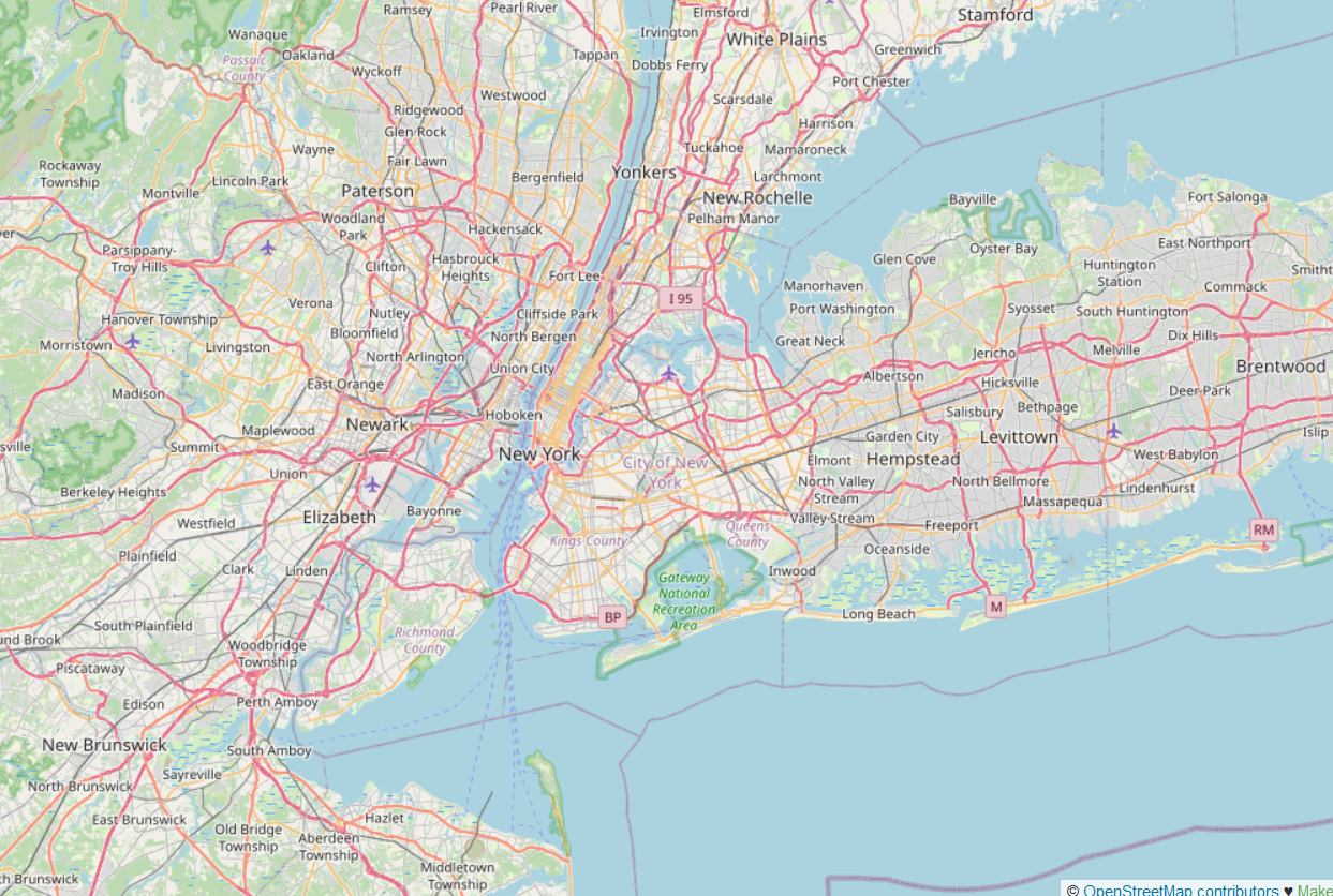
The abandoned right-of-way of the Rockaway Cutoff, or Rockaway Beach Branch, is an attractive target for reuse by some groups. Area railfans have wanted to do something with it for years, and I was mostly negative about these plans, but more recently, QueensLink has emerged as a serious plan to extend the subway along the Rockaway Cutoff, to connect neighborhoods in southwestern Queens to one another and to Manhattan, where current connections do not exist (in the middle) or only serve Midtown Manhattan indirectly and slowly (in the south, via the A train). The right-of-way is wide enough that most of it can also accommodate additional infrastructure, in the case of this plan a bike trail.
The problem is that this more serious plan is still not getting much political play. This is not because of the typical reasons people may think of, such as high costs or NIMBYism. Rather, a competing plan for the same corridor, Queensway, wants to turn it into pure parkland, and is backed by a power broker with opinions and connections. The QueensLink advocates have asked for and been so far refused planning money for an environmental impact statement, which step is in better infrastructure environments apolitical; instead, Mayor Eric Adams is connected with a Queensway backer and thus favors Queensway.
The QueensLink project
QueensLink is a subway extension, with a short tunnel to get from the Queens Boulevard Line’s local tracks to the Rockaway Cutoff. Where there is room, a bike trail is included on the same corridor.

As this is a former rail mainline, the connections to the crossing subway lines are not great – the subway placed stations at major street intersections, leading to long walks at the Jamaica and Liberty Avenue transfers. In contrast, the connection to the LIRR is good: there is no station there today, but there used to be one, and it could be reopened, especially now that the Atlantic Branch is retooling to be more useful for urban service, with more stops, higher frequency, and perhaps integrated fares.
The subway connection makes this proposal viable. I previously criticized a proposal to run commuter rail service on the Cutoff, since it would crowd out the busy LIRR Main Line. In contrast, QueensLink has the new branch using the Queens Boulevard local tracks, which are undersubscribed even at rush hour, to the point that it may even be possible to run three rush hour services on the same tracks and not just two like today. The G doesn’t run to Forest Hills, for good reason, but the new service would vacate space at the Forest Hills terminal of the local tracks to the point that it could potentially be viable.
At the Transportation and Land Use program at Marron, we’re building tools to estimate not just costs for public transit construction but also ridership, and it’s likely that QueensLink will be next on our agenda right after the Interborough Express. I can’t give more than first-order estimates now, but it’s notable that the closest parallel bus corridor, Woodhaven, has high ridership: it carries four local or SBS routes and four express routes, with 31,000 weekday boardings among them. Then there’s the possibility of faster service to JFK Airport via QueensLink. It’s not going to be the Second Avenue Subway of Queens by ridership, but because only a short tunnel is needed, it’s not going to come close to Second Avenue Subway in costs either.
QueensLink and Queensway
The alternative to QueensLink isn’t doing nothing, as is usually the case. Some political players have eyed the corridor for a trail project called Queensway. The idea of Queensway is to create more parkland in the area, including a hiking and bike trail; as the map above shows, there is no shortage of parkland there. There’s an obsession of urbanists in the United States with linear parks, in imitation of the High Line; one attempt at imitation even wanted to build a park underground in a former streetcar terminal and called it the Lowline.
I want to dwell on the politics of Queensway, because I know I have a lot of readers in the general neoliberal and rationalist communities, including specifically in New York, and the political support for it is not what their first instinct might be.
Often, it’s the case that public transit projects are supported by broadly developmentalist interest groups, who are also fairly YIMBY, and tend to be rooted in professionals and office workers commuting to city center, and opposed by NIMBYs, who tend to be rooted in longstanding neighborhood residents and small business owners. Neighborhood NIMBYs often like parks, because they’re local improvements; when we studied the Green Line Extension in Boston, we saw some local interest groups demand money for a trail as a precondition to supporting the light rail line.
And this is not at all what is happening with the Rockaway Cutoff. Local interest groups are not consistently anti-QueensLink and pro-Queensway. Some are, but in at least one case, a local advocate came to argue on NIMBY grounds against Queensway, which would bring pedestrians to their backyard, and for QueensLink, since the passing train would not cause unwanted impact and would serve the area. On net, YIMBYer groups are more pro-QueensLink – for example much of the community at the northern end of the corridor, in Community Board 6, which due to its location on the subway has a more pro-transit and pro-development orientation. But it doesn’t boil down to these class interests pitting professional workers against small business owners, at all. Rather, it’s rather random, boiling down to individual power brokers for Queensway.
What autocrats want
I highlight the randomness of the interest groups for Queensway, because it relates to the broadly autocratic style of some leaders, who the de facto system of government in New York empowers too much. In the 2010s, Andrew Cuomo liked the idea of Queensway, and if he wanted something, anyone who wanted to stay in the good grace of the local power system had to support it. The backward air train to LaGuardia, hated by transit activists in the city from the start, is such an example – while Cuomo was in power opposition was restricted to people outside city and state politics, like the technical advocacy community or Alexandria Ocasio-Cortez. Then Cuomo left office and because nobody really wanted it, this project died. Queensway survives, I think partly because it’s not a multi-billion dollar investment, and partly because some power brokers do like it and have attached themselves to Mayor Eric Adams, such as political operative and lobbyist Travis Terry.
The point of this is not that Adams wants Queensway and therefore it will happen. Rather, it’s that, in a system with a democratic deficit like New York, professional decisions often boil down to which random advocate happens to have the ear of the autocrat. I keep contrasting this with the situation in Berlin, in which bike lanes and pedestrianization have been put on hold and even been reversed under Mayor Kai Wegner (CDU) – but Wegner ran on this agenda in the election and CDU came first, and the pivotal party, SPD, chose to enter a coalition with him and not with more left-wing parties under a known-quantity (and disgraced) leader in Franziska Giffey, whose conservative-for-SPD politics and poor relationship with the left was well-known. I dislike this outcome, but voters knew what they were getting. In contrast, in New York, Adams did not run on any explicit agenda of not building public transit, or even on support for interest groups that oppose transit (again, the Queensway support is more individualized than neighborhood-scale NIMBYs). He just makes abrupt decisions, often sniping the judgment of the city’s own civil service, based on what one favorite asks.
The way forward
In healthy infrastructure construction systems and also in Germany, the planning is not politicized; the yes/no decision on what to build must be made by politicians, but the menu of options with their costs and benefits is prepared by the civil service. In contrast, in the United States, even the choice of which projects get an environmental impact study is politicized; QueensLink advocates are asking for money for an EIS, which in the United States is where planning is done, but even that is stalled politically.
The problem is that the message this behavior by the city and state sends is that New York is too messed up to invest in. Private actors who make investment decisions need some amount of political stability and predictability. A political culture of caprice, in which everyone must constantly follow political gossip to have any idea what the autocratic mayor or governor (or in some countries president or prime minister) will do, or else be swamped by otherwise inexplicable investment decisions, screams “go elsewhere, we don’t want you.” Even turning an EIS into a big political ask screams the same thing: “we can’t do, so merely studying is an achievement by itself and you must pay fealty.”
New York’s current system deters investment, not through taxes or union empowerment, but through opacity and unpredictability. I don’t want to turn the question of one right-of-way in Queens into an existential issue that it is not, but on the margin, stonewalling on QueensLink because some politically connected actor personally wants Queensway reinforces this system that repels investment, whereas treating the EIS as an apolitical step and then based on the results of further planning building it or not based on broad interest agreement signals that New York can and wants to build things. It’s the city’s choice.


 , and
, and  ; my post just looks at specific high-speed rail connections rather than trying to abstract it out, but the point is that in the presence of an initial network, even weaker-looking extensions can be worth it because of the connections to more nodes. Finally, this builds on what I said five days ago about