At an event run by ReThinkNYC, Andy Byford spoke for five minutes in support of through-running at Penn Station. They put out the press release, so I feel it’s fine to reprint it in full here with some comments.
The timing works well for what I’m involved in. The Transportation and Land Use program at Marron is about to release a playable 3D model of a reimagined Penn Station designed around through-running and around maximally efficient passenger egress, with above-ground structures like Madison Square Garden removed; I was hoping for the model to come out in June in time for the debate about whether to extend the Garden’s operating permit, but that debate seems to be going the right way regardless, and the Garden itself is open to moving, for a price. Then, the Effective Transit Alliance is about to release a long report explaining the issue of through-running, why it’s good for New York, and how to implement it.
The bulk of what we’re about to do on this side of the TLU program for the next year is figure out timetable coordination for regional and intercity rail, so showing how everything would fit together should take some time, but the question of feasibility has already been answered; the work is about how to optimize questions like “where do high-speed bypasses go?” or “which curves is it worthwhile to fix?” or “which junctions should be grade-separated?”.
First of all I am honored to be in a conversation with people that I regard as absolutely luminaries in the transit space, people like Prof. [Robert] Paaswell, people like Dr. [Vukan] Vuchic. These are luminaries to me in the field of, not only transport planning, but in the particular area we’re talking about today, namely through-running.
I was very encouraged to hear Assemblymember [Tony] Simone talk about the benefit of avoiding demolishing a beautiful part of New York City, which although I live in D.C. now, is a city that is so dear to my heart. I feel I’m an adopted New Yorker, I love that place and it would break my heart to see beautiful buildings torn down on Eighth and Seventh Aves. when they don’t need to be.
I should say at the get-go, that I’m not speaking on behalf of Amtrak. I’m speaking as a railway professional. I’ve worked in transit now for 34 years. But I just feel this is a golden opportunity — and the assembly member mentioned that — and one of the other speakers also mentioned the benefits of through-running and made reference to what happened in London. London learned that lesson. There are two effectively two cross London railroads.
There’s the Elizabeth Line, which I had the pleasure of opening with Her Majesty the Queen back in 2022, and that’s has been transformative in that where people used to have to jump on the Central Line, had to get off at Paddington and then go down to the Central Line and or down to Lancaster Gate and go through Central London to go to East London to Liverpool St. and then go out the other side, now they don’t have to.
The Central Line has been immediately relieved of pressure and you’ve got a state of the art, very high speed actually, through-service state of the art railway, under the wires. Beautiful stations, air conditioned, which at a stroke has been a game changer for London, connecting not only the key parts of Central London, but also Heathrow Airport, Paddington, Liverpool St., Canary Wharf and the City of London. It is a game changer. People in Frankfurt, people in Amsterdam, people in Paris and dare I say, New York, are probably gnashing their teeth because that was a game changer for London.
Well, I live in the States now, I’m going to be an American hopefully in a few years time and I want to do my bit for the States. So it seems to me that this is a golden opportunity for the U.S. and for New York City to have something similar to the Elizabeth Line, to have something that has that economic regenerative impact in New York.
And the other corridor of course, was Thameslink, that preceded Crossrail, but that’s the north/south corridor. There again, once upon a time you used to rock up in South London and have to get on the Tube you’ll be getting on the Vic Line or you’re getting on the Northern and have to go up to Euston or Kings Cross to go north.
Now, you don’t have to do that and what London has seen is the benefit of that cross-London traffic and that through-running because you’ve got not only the economic benefits of the City but the knock-on effect of north, south, east and west of businesses popping up, of housing being developed and of relief to the existing transport lines.
So I don’t know how this is going to pan out, but what I would say, Sam [Turvey]: is good for you for at least calling the question. This is a golden opportunity. It’s not just about building something that’s more aesthetically pleasing — important as though that is, Penn Station is kind of an embarrassment — but you can’t fix it by just putting in a few light boxes, by just heightening the ceilings, by just widening a few corridors.
If we’re going to do all of that, why not take the opportunity to fix the damn thing once and for all, which is, I’m going to say: get rid of the pillars, which means move MSG, but at the very least, do something with the track configuration to enable through-running.
So that’s it, that’s my pitch. I do stress that’s my personal opinion. I’m not speaking on behalf of Amtrak. I don’t know all the facts. If it was the case that someone asked me to have a look at this, I’ll be honored to do that, but I’m just speaking as a private person who cares about New York City, who cares about the States and who’s seen what good looks like along with people far smarter than me like Prof. Paaswell and Dr. Vuchic. So thank you so much.
In talking to both activists and government officials, I’ve encountered some assumptions that are clearly incompatible with any sort of viable public transportation provision. In some cases, when I don’t feel obliged to be polite, I immediately react, “Then you will not have public transit” or “you will not have trains.” These include both operations and construction. None of the political constraints mentioned in those conversations appears hard; it’s more a mental block on behalf of the people making this statement, who are uncomfortable with certain good practices. But there really is no alternative; social scientific results like various ridership elasticities can no more be broken than economic laws. Moreover, in some of these cases, half-measures are worse than nothing, leading reform among certain groups of activists to be worse than if those activists had done literally anything else with their spare time than advocacy.
The practices: operations
There’s a lot of resistance among American transit activists to the sort of bus operations that passengers who are not very poor are willing to rely on.
Frequency
American advocacy regarding frequency comes extremely compromised. The sort of frequencies that permit passengers to transfer between buses without timing the connection are single-digit headways, and the digit should probably not be a 9 or even an 8. Nova Xarxa successfully streamlined Barcelona’s bus network as a frequent grid, with buses coming every 3-8 minutes depending on the route. Vancouver and Toronto’s frequent grids are both in the 5-8 minute range.
However, American transit agencies think it’s unrealistic to provide a grid of routes running so frequently. Therefore, they compromise themselves down to a bus every 15 minutes. At 15 minutes, the wait time is too onerous; remember that these are buses that don’t run on a fixed schedule, so a transferring passenger is spending 15 minutes waiting in the average case and 30 minutes in the worst case. These are all city buses, with an in-vehicle trip time in the 15-30 minutes range. A bus system that requires 30 minutes of worst-case wait might as well not exist. If this replaces buses that run every 20 or 30 minutes on a fixed schedule, then this makes things worse.
Bus reliability
Buses naturally tend to bunch. The only lasting solution is active control, i.e. better dispatching. I’ve heard managers treat the prospects of hiring a few more dispatchers as a preposterous extravagance. This is not because of some political diktat; hiring freezes are stupid, but those managers don’t push back and don’t hire more dispatchers even when there’s no hiring freeze.
There’s a bit more interest in technological solutions, but when I was trying to explain conditional signal priority to some managers, they didn’t really get it. This is not quite the same issue – this is not a compromise due to perceived (almost never actual) political constraints, but rather lack of technical chops and disinterest in acquiring it. But lacking such chops, the marginally labor-intensive solution is the only one, and yet it’s not done.
Bus-rail integration
American managers love to slice the market; this includes transit managers, in a situation where the issue of frequency makes any makret segmentation a net negative to all riders. In the suburbs, this results in a segmentation of buses for the poor and trains for the rich; once the buses have average incomes that are only around half the area average, both managers and activists treat them as a kind of soup kitchen, and resist any attempt at integration.
This is less bad in the main cities – bus-subway integration in the American cities that have subways is good, except for Washington. But in Washington on Metro, and everywhere on commuter rail, there’s resistance to fare integration; New York makes incremental changes to reduce the commuter rail fare premium, but until fares are equalized and transfers made free, this is just a subsidy to the rich segment of the market, rather than a breaking down of the segmentation.
The practices: construction and governance
I bundle governance and construction because, in practice, all the examples I’ve seen of people compromising their own ability to do cost reform involve governance.
Learning from others
At a meeting with some government officials to discuss our costs report, one of the people involved asked us if there are any good examples from the United States, saying that as a matter of politics, it’s hard to get Americans to adapt foreign governance schemes. I don’t know how important this person was; long-time readers know that I don’t know Washington Bureaucratese or its Brussels, Albany, Sacramento, etc. equivalents, and in particular I can’t tell from a title, CV, or social cues whether I’m talking to a decider or a flunky. I certainly did not say “Okay, then you won’t have cost-effective construction, and over time, Americans will learn that the government can’t do anything”; I tried explaining why no, it’s really important to learn from foreigners, especially nonnative Anglophones, and I don’t think it got through.
Building up state capacity
Something about Americans makes them hostile to the idea that the government overtly governs. This is not because they’re inherently ungovernable, but because some of them like to pretend to be. This has led to workarounds, which Bring Back the Bureaucrats by John DiIulio (this is DIIULIO in all caps, not DILULIO) calls the leviathan by proxy model, in which the state is outsourced to consultants. Thus, dismantling the state and instead calling in consultants is supposedly the only way to get Americans to accept government spending. This was said to us, at the same meeting as in the above section, by a different person.
This is, like most political claims that justify inaction, bunk. Consultants are not a popular group in the broad public. “This all goes to consultants” is a standard line justifying misturst of government, regardless of politics, to the point that generic anti-everything populists like to make consultants public enemy #1. In New York, even the unions make this one of their rallying cries in opposition to various kinds of outsourcing; there’s no excuse there to keep hiring consultants to do design and then not knowing how to manage them, where what the MTA should do is replace its leadership with people who know better and staff up to the tune of a four-figure planning and engineering department. It costs money. It costs less money than the New York premium for construction, the difference amounting to around a full order of magnitude.
Saying no to surplus extraction
The United States abounds with examples of infrastructure projects that got outside funding, which could be federal, or even just state if the scale is small enough, that local departments took as opportunities for getting other people’s money.
The solution there is simple: just say no. This requires overruling local regulators, but I routinely see states do it when they care to – Long Island’s entire group of interests, including the LIRR, local officials, and state electeds, opposed Metro-North’s Penn Station Access due to turf battles over train slots into Penn Station that were not even in shortage, until Andrew Cuomo fired LIRR head Helena Williams and all of those supposedly intractable voices were silenced. The ability of California High-Speed Rail to defeat rich NIMBYs in Silicon Valley is also notable; the project is moribund, but not because of NIMBYs.
And somehow, when a municipal fire department or parks department makes demand, the immediate reaction in the same country that did the above is to give in. Federal officials who I’m fairly certain are important deciders told me stories about how “in our system of government” (exact words) there is expectation of municipal autonomy and it breaks some unwritten covenant to interfere when a fire department refuses to certify light rail construction that meets fire code, as in suburban Seattle, because the department wants it to go beyond the code. The state that does not take responsibility and respond appropriately – which in this case ranges from disestablishing the fire department in question to disestablishing the entire suburb – is the state that will not really be able to expand its urban rail network, which is really sad since Seattle’s last extension was good and its high rate of housing growth makes it a good place to invest.
Benchmarking to an external world
Activists and managers may tell themselves that they’re just following some kind of necessary political logic. But at the end of the day, neither the passengers nor the contractors care. If the political logic dictates that the bus system be bad, then passengers will just not use it, and instead get cars and drive and vote against any further increases in transit funding due to memory of its low quality. Likewise, if the political logic dictates that capital construction be run by incompetents with no successful (i.e. non-Anglosphere) experience who can’t say no to requests for other people’s money and who mismanage the consultants, then the region will just not be able to build, even if, like Seattle, it clearly wants to. There’s an external world out there and not just the machinations of political insiders.
Deutsche Bahn released a study three days ago proposing to build a Europe-wide network of high-speed trains. There aren’t too many details – the fully study PDF is corrupted (update: this direct link works) – but we can already learn a lot from the proposed map, which is available. I’m glad that proposals like this are out, but this one reminds me of the recent proposal for a massive expansion of the Berlin U-Bahn, which leaves a lot to be desired, comprising both necessary priorities and questionable lines; this time, there are some priorities that should be included but aren’t.
The map is clearly intended as a Europe-wide network. For reasons I don’t quite get, Britain and its under-construction High Speed 2 system is not included – it’s not an EU or Schengen member but neither are Serbia and North Macedonia, and meanwhile, Northern Ireland is included.
In some places, the proposed lines are taken straight out of current proposals. This is the case in Spain, Portugal, Italy, and France: on the French map, lines that are in active planning like Bordeaux-Dax and Toulouse-Montpellier/Perpignan are visible and so are lines that are stalled like Marseille-Nice or the Paris-Orléans-Lyon relief line.
There’s little to comment on in these places, save that some of the international connections are underbuilt under current plans. It’s frustrating that the current plans include a connection from Bordeaux to Basque Country and thence Madrid, and a more direct connection from Madrid to Pamplona, but not the short connection from Pamplona to the French border for faster Paris-Madrid service; French and Spanish trains are fast and these two cities, the two largest single-core regions in the EU, should be no more than 4.5 hours apart via the most direct routing. Italy is also, equally frustratingly, missing a fast connection from Milan into Switzerland, hooking into the new tunnels across the Alps with additional under-construction fast lines on the Swiss side; this way, the route from Zurich to Milan has an orphaned-looking fast section in the middle.
In Eastern Europe and Scandinavia, the map looks taken from existing proposals as well. Finland’s system is based on existing proposals. Their benefit-cost ratios were assessed to be underwater earlier this year (using atypically low estimates of the travel time elasticity – Helsinki-Tampere looks like they’re estimating -0.17, which is ridiculous; try -2), but this doesn’t mean they won’t happen. Sweden recently decided against a domestic high-speed rail system, but this again may be revived. Czechia is planning its own system, with international connections. But farther east, the lines get more fanciful – the Romanian and Hungarian networks look pretty overbuilt relative to the sizes of the cities in those countries, which aren’t growing.
And then there’s the German core. The domestic and international lines here mostly look like a very extensive proposal. Practically every city is on the map, to the point that there’s a 300 km/h line from Leipzig to Chemnitz. Some of those yellow lines on the map are already in planning, like Augsburg-Ulm, Hanover-Hamm, and Erfurt-Fulda.
But then there are the missing ones. Fulda-Hanau, currently on the planning board, is for some reason omitted. Berlin is getting two new high-speed rail lines to the south, one to Dresden and a separate one to Görlitz (district population 248,000), but nothing to Halle and Leipzig, even though that would also speed up the trains to Munich. This can’t be about the false belief that a four-hour trip time is good enough and there’s no point in speeding it up further, because then why would they include a spur to Chemnitz? It’s a three-hour trip today with a 40-minute transfer at Leipzig; the time saved from speeding up Leipzig-Chemnitz is less than what could be saved just by timing the connection better, let alone by doing that and also speeding up Berlin-Leipzig.
The international connections are pretty good. There’s finally a fast line to Zurich, plus two to Prague, plus an all-fast connection from Munich south across the Alps. Paris-Frankfurt is on the map, via Mannheim. The slow section to the Belgian border is fixed; the Netherlands gets four distinct connections, of which two I do not get (the three southern ones can be consolidated to one without taking a huge hit to trip times).
But then those international connections mostly just feed existing or planned lines. Thus, the fast line from Munich to the Austrian border is not accompanied by speeding up the Westbahn; Salzburg, per DB, should get fast trains to Munich and the rest of Germany, and Linz should get fast trains via two different lines, but then Vienna should stay connected by a medium-speed link.
And yet, at least in and around Germany, it looks like DB is proposing too much, not too little: cities like Szczecin, Bremerhaven, Kiel, Rostock, Chemnitz, and Görlitz are too small to be worth building a dedicated line to. Either send an ICE at lower speed from the nearest large node or run slow trains and try to time some connections. It’s proposing a 6,000 km network for Germany; I did a fair amount of crayoning in 2021, and got to somewhat more than 4,000, including international connections. The current network, including lines that shouldn’t be changed like Berlin-Hamburg or that are under construction like Karlsruhe-Basel, is around 1,700. So as with the Berlin U-Bahn map, it’s best to think of the current proposal as about half good lines, and half things that most likely shouldn’t see the light of day (Chemnitz, again).
I suspect the reason small cities like Kiel are included is that high-speed rail plans in Germany face constant criticism by technical railfans who think that small cities generate more traffic than they actually do. Part of it is that railfans and Green voters take the train at far higher modal split than does the general public, and thus use the train to get to places where everyone else not only drives but will keep driving even with better frequencies and connections. The same group also doesn’t mind sitting two hours longer on a train than at TGV speeds. Thus, rail advocacy in Germany kneecaps itself by insisting on the least cost-effective treatments. DB may be responding to such advocacy by proposing high-speed lines even to cities that are far too small to justify such connections, to preempt any criticism that cities like Görlitz are left out.
And this is sad, because most of the cross-border connections on the map out of or near Germany are really solid, and unfortunately underrated in current planning. I hope DB takes them seriously enough to commit to partnering with the other-country railway (SNCF, ÖBB, etc.) and building them, rather than shoving them below the priority level of a high-speed line from Berlin to Rostock.
Two days ago, the federal government announced that it was funding the HudsonTunnelProject, adding two new tunneled tracks between New Jersey and New York Penn Station. The total grant is $6.88 billion, representing slightly less than half of the projected cost, which is officially still $16 billion in year-of-expenditure dollars but may rise to $17 billion; nearly all of the rest of the budget is already matched in state grants from New York and New Jersey, and so for all intents and purposes, the project should be considered fully funded. Frustratingly, it’s an extremely expensive project, and yet its benefits are high that it may still pass a benefit-cost analysis – and the more operational improvements there are down the line, the higher the benefits.
The grant only covers the bare tunnels and a $2 billion project to do long-term repairs to the existing tunnels after damage suffered in Hurricane Sandy. The $14 billion new tunnels are the centerpiece of the wider $40 billion Gateway Program, which includes other items that are said to be necessary for an increase in capacity. But most of those items by cost are duds, such as the completely useless $7 billion Penn Station Expansion program to condemn an entire city block to add tracks, or the useful but not at this price $6 billion Penn Station Reconstruction program to improve pedestrian circulation at the existing station. There still remain necessary improvements on the surface to go along the Hudson Tunnel Project, but they are small – a junction fix here, some double-tracking of a single-track branch there, some high-platform projects to improve reliability yonder.
The reporting on the project says that it will be overseen by the Federal Transit Administration (FTA), not the mainline-specific Federal Railroad Administration (FRA). It looks like this is coming from the general bucket of money for mass transit in the Bipartisan Infrastructure Law, rather than from the $30 billion dedicated to the Northeast Corridor; thus, the budget for other Northeast Corridor improvements should remain $30 billion, rather than $23.12 billion.
The issue of costs
The Hudson Tunnel Project is about five kilometers in length, from the portal on the western slope of the Palisades to the existing Penn Station:
The alignment, as can be seen in the picture, is not closely parallel to the existing tunnels. On the Manhattan side, the alignment is fixed in place, due to the construction of the Hudson Yards project since the project was first mooted in the early 2000s, when it was called Access to the Region’s Core (ARC); the only available alignment between building foundations is as depicted. Under the Hudson and in New Jersey, there are no such constraints.
What is far more suspicious is that 5 km of double-track tunnel, even partly underwater, even partly in Manhattan between skyscraper foundations, are said to cost $14 billion in total. This is not just the usual problem of high New York costs. Second Avenue Subway’s hard costs were 77% stations and station finishes and only 23% tunnels and systems; excluding the stations, and pro-rating the soft costs, the costs in 2022 dollars were only about $500 million per km. There is an underwater premium, but it doesn’t turn $500 million per km into nearly $3 billion per km, nor is the expected inflation rate over the project’s 2023-35 lifetime high enough to make a difference.
What’s more, the underwater premium is highest where the costs are already the lowest. The New York cost premium for civil infrastructure is rather small, only about a factor of around 3 over comparable European projects. Systems and finishes have a considerably higher premium, due to lack of standardization; stations have an even higher premium, due to overbuilding (the Second Avenue Subway stations were 2-3 times as big as necessary, and the two smaller ones were also deep-mined at an additional cost). The installation of systems like electrification and cables should not cost more underwater than underground – the construction of the tunnel and its lining is where the premium is. Whatever we think the underwater construction premium is – a factor of 2 is consistent with some Stockholm numbers and also with the original BART construction in the 1960s and early 70s – it should be lower in New York.
Some of it must come from ever worse project management and soft costs. The destruction of state capacity in the English-speaking world, and increasingly in nonnative English-speaking countries influenced by the UK like the Netherlands, is not a completed process; it is still ongoing. Soft costs keep rising, and the response to every failure is to add yet another layer of consultants or another layer of review. Second Avenue Subway phase 2 manages slightly higher per-km costs than phase 1, despite having less overbuilding, and from my encounters with the people in charge of capital construction at the MTA, it’s not hard to see why.
And yet, even relative to the highest costs of phase 2, Gateway is overpriced. The level of experience the people running this project have with capital construction at this scale is less than that of the MTA, and this should matter. And yet, even that doesn’t explain the large jump in costs.
Is it possible to do better?
Well, once the almost $16 billion for the project is there, it will be spent. The main reason one might oppose overpriced projects like Second Avenue Subway phase 2 even if their benefit-cost ratio is okay (which, for both phase 2 and the Hudson Tunnel Project, is iffy, though not obviously bad), is that pressure to reduce costs before approval can result in efficiencies. But once a budget is approved, nobody will make a serious effort to go significantly below it.
That said, the only smoking gun I have for how to make this project cheaper pertains to the $2 billion for fixing the existing tunnels. Currently, the timetables for both Amtrak and New Jersey Transit trains across the tunnels are written so that on weekends, only one of the two single-track tubes is in operation. Thus, maintenance work can be done on the other tunnel for an uninterrupted 55-hour period. However, Amtrak rarely takes advantage of this. In fact, reporting in the New York Daily News has found that over the last few years, only about once every three months – 13 times in a four-year period from mid-2017 to mid-2021 – has there been a full weekend repair job in one of the tunnels. Accelerated repairs would be able to reduce the costs of the fixes through greater efficiency, and, since American government budgeting is done in nominal dollars, a lower price level than in the mid-2030s.
It’s likely that such egregious examples also exist for the main project, the $14 billion new tunnels. I don’t know of any such example, and I don’t think it’s worthwhile stopping the project over this; but it’s important to remain vigilant and remember that while the tunnels are fully funded for all intents and purposes, a small gap remains and should be fillable without new money.
The benefits of the tunnels
The costs are very high. But what are the benefits?
In isolation, the benefits are that capacity across the Hudson would double. This would enable doubling commuter rail traffic. Before corona, the trains were very crowded, to the point of suppressing demand; ridership is lower now than it was then, but east of the Hudson, Metro-North is at 78% of pre-corona ridership and rising fast. Moreover, the prospects of future growth in commuting in New Jersey are better than those in suburban New York and Connecticut, since New Jersey permits housing at an almost healthy rate, 4 annual housing units per 1,000 people, whereas Long Island permits about 1, Westchester 2-3, and Fairfield County 1.5-2.5. There’s enough pressure in New Jersey even in the short term that a ridership flop like that of East Side Access is very unlikely.
That said, New Jersey Transit only had about 310,000 weekday riders in 2019, double-counting transfers (of which there aren’t many, unlike on the LIRR). Not many more than half those trips even originated or ended at Penn Station – one of the adaptations to overcrowding on New Jersey Transit is to send about half the trains from the Morris and Essex Lines to Hoboken, from which passengers take PATH into the city, and another is for passengers to get off at Newark and transfer to PATH there. Penn Station’s ridership in 2019 was 94,000 boardings, or 188,000 trips; that is the number that could potentially be doubled. So, $14 billion for 188,000 trips; this is $74,000 per rider, which is too high, and if that is the only benefit, then the project should be canceled.
However, the Hudson Tunnel Project interacts positively with every operational improvement in commuter rail. If off-peak frequencies are increased so that passengers can use the trains not just for rush hour commuting, then ridership will rise. Of course, peak frequency is not really relevant to off-peak ridership – but there are advantages from the new tunnels to off-peak service, such as more cleanly separating Northeast Corridor service from Morris and Essex service, improving reliability for both.
And then there are all the necessary small improvements, such as electrification. For example, right now, the Raritan Valley Line today is unelectrified, and passengers have to transfer at Newark to either PATH or a Northeast Corridor or North Jersey Coast Line train to Manhattan; only a handful of trains run to Manhattan using dual-mode locomotives, none at rush hour. The current service plan with the new tunnels is to run ever more trains with dual-mode locomotives, which are exceptionally expensive, heavy, and unreliable. However, the new tunnels interact positively with electrifying the Raritan Valley Line, currently the busiest diesel line in New Jersey, and with wiring short unelectrified tails on the North Jersey Coast and Morris and Essex Lines. These would raise both peak and off-peak ridership – and the extra capacity provided by the new tunnels improves the business case for them, even if the business case is healthy even purely on off-peak travel.
The same is true of platforms. The low platforms at most stations impede efficient boardings. They take too long at rush hour, and they’re inaccessible unless a conductor manually operates a wheelchair lift; conductors are not really cost-effective on commuter trains even at the wages of the 2020s, let alone those of the future. As with electrification, the case for converting all stations to high platforms for level boarding is strong even on off-peak ridership; the benefits are high and the costs are low (New Jersey Transit appears capable of raising platforms for $25 million per station). However, commuter rail managers and suburban politicians are squeamish and ignorant of best practices and only really get peak ridership; thus, the higher peak ridership expected from the new tunnels not only improves the already-strong business case for high platforms, but also makes this business case easier to explain to people who think that off-peak, everyone must drive.
With such improvements to speed and reliability – modern rolling stock (which none of the region’s agencies is interested in acquiring), electrification, high platforms, some junction fixes, and better timetabling (which the region will have to adopt for greater peak throughput) combine to a speed increase of a factor of about 1.5, with all the benefits that this entails.
Necessary efficiencies
Much of the benefit of the Hudson Tunnel Project comprises necessary improvements on the surface, some of which I expect to happen as ancillaries. But then there is also the issue of necessary efficiencies in New York.
The issue is that the current operating paradigm involves very long turns at Penn Station. LIRR trains terminate from the east and New Jersey Transit trains terminate from the west, and neither railroad turns trains especially quickly. The turn times are on the order of 20 minutes; mainline trains in the United States can reverse direction in service in 10 minutes when they need to (for example, if they’ve arrived late), and even eight minutes look possible, and outside the United States, constrained terminals like Tokyo Station on the Chuo Line or Catalunya on FGC do it much faster.
The relevance is that agency officials keep saying, falsely, that Penn Station Expansion is necessary for the full increase in capacity coming from the new tunnels. But they are not going to get the money for the expansion; it competes with so many other priorities for a pool of money, $30 billion for the entire Northeast Corridor, that is large compared to normal-world costs but small compared to American ones. This means that they’re going to have to make necessary efficiencies.
Through-running is one such efficiency. But there are others – chiefly, turning faster at terminals, since the new tunnels would mainly feed stub-end tracks. This, in turn, means better service in general, with lower operating costs and (if there’s through-running) better service for passengers.
On just a raw estimate of extra peak capacity, there just isn’t enough ridership to justify $14-16 billion in funding for new tunnels. But once all the necessary improvements and efficiencies come in, the benefit-cost analysis looks much healthier. It doesn’t mean anyone should be happy about the budget – agencies and area advocates should do what they can to make sure money is saved and the same budget can build more things (like all these necessary improvements) – but it could be more like the extremely high-cost and yet high-benefit Second Avenue Suwbay phase 1 and not like the failure that is East Side Access.
East Side Access opened in February, about four months ago, connecting the LIRR to Grand Central; previously, trains only went to Penn Station. The opening was not at all smooth – commuters mostly wanted to keep going to Penn Station, contrary to early-2000s projections, and stories of confused riders were common in local media. I held judgment at the time because big changes take time to show their benefits, but in the months since, ridership has not done well. On current statistics, it appears that the opening of the new tunnel to Grand Central has had no benefit at all, making this project not just the world leader in tunneling cost per kilometer (about $4 billion) but also one with no apparent transportation value.
What is East Side Access?
Traditionally, of New York’s two main train stations, Penn Station only served Amtrak, New Jersey Transit, and the LIRR, whereas Grand Central only served Metro-North. East Side Access is a tunnel from the LIRR Main Line to Grand Central, permitting trains to serve either of the two stations; an under-construction project called Penn Station Access likewise will permit one Metro-North line to serve Penn Station.
The tunnel across the East River was built in the 1970s and 80s together with the tunnel that now carries the F train; East Side Access was the project to build the connection from this tunnel to Grand Central as well as to the LIRR Main Line in Queens. The Grand Central connection does not lead to the preexisting Metro-North terminal with its tens of tracks, but to a deep cavern:
What was East Side Access supposed to serve?
Penn Station’s location is at the southwestern margin of the job concetration of Midtown Manhattan. Grand Central’s location is better; the studies done for the project 20 years ago found that for the majority of LIRR commuters, Grand Central was closer to their job than Penn Station. In 2019, there were 589,770 jobs within 1 km of Penn Station’s northeast corner at 7th and 33rd, of whom 48,460 lived on Long Island; within 1 km of Grand Central’s southern entrance at Park and 42nd, the corresponding numbers are 680,586 and 57,457.
Based on such analysis, the plan was to send as many trains as possible to Grand Central, at the expense of trains that used not to enter Manhattan at all but instead diverted to Downtown Brooklyn (within 1 km of Atlantic and Flatbush there were 41,360 jobs in 2019, of which 3,895 were held by Long Islanders). The central transfer point at Jamaica was reconfigured to no longer permit cross-platform transfers between Brooklyn- and Penn Station-bound trains in order to facilitate more direct trains to Grand Central.
The state promised large increases in both capacity and ridership; in 2022, joint Metro-North and LIRR head Catherine Rinaldi said they were increasing service by 40%. Unfortunately, ridership has flopped.
Ridership is a flop
The most recent publication about New York commuter rail ridership is from a week ago. LIRR ridership in May was about 5.6 million, with a peak of 229,000 passengers per weekday; ridership before corona was 316,000 per weekday. Metro-North, with no opening comparable to that of East Side Access, had 5.43 million riders in May with a peak of 215,000 passengers – but pre-corona ridership was 276,000. Metro-North has held up better the LIRR and recovered faster: May 2023 was 28% above May 2022, whereas for the LIRR, it was only 23%.
The same publication speaks of East Side Access positively – as it must, as an official report. It says the share of LIRR ridership is transitioning toward 65% Penn Station, 35% Grand Central. But this by itself already raises questions. The easier access to Grand Central and the extra capacity should have raised ridership; in the report, no surge is apparent since February of this year. Judging by the example of Metro-North, it appears that no net ridership has appeared as a result of the new project.
What’s going on here?
I’ve spent many years criticizing reverse-branching, in which a trunk line outside city center splits into branches in the core, in this case some trains serving Penn Station and others serving Grand Central. For East Side Access, my recommendation was to have one specific track pair, such as the express Main Line tracks, only carry trains to Grand Central, and the rest, such as the local tracks and Port Washington Branch tracks, only carry trains to Penn Station. The disappointing ridership of East Side Access has led some area transit advocates to criticize the MTA on the grounds that the problem is one of reverse-branching.
The media stories in late winter and early spring of confused commuters are certainly consistent with my criticism of reverse-branching. Everything that’s happened is consistent with that criticism, and yet I’m not certain that this is what’s going on. After all, East Side Access also adds new service and new capacity. Potentially, it’s about the loss of Jamaica transfers, but then which trains would people even want to transfer from?
The main mechanisms by which reverse-branching hurts ridership are that it makes schedule planning too complex and thereby reduces reliability, and that the frequency on each reverse-branch is reduced. LIRR scheduling is already extremely complex, with one-off express patterns and trains weaving around one another at rush hour; in 2015, I looked at some rush hour schedules and compared them with the rolling stock’s technical capabilities and found that even relative to the derated capabilities of the trains, the timetables are padded by 32% on the Main Line. (Metro-North seems comparably padded.) East Side Access would hardly make this much worse. The second mechanism is frequency – but at rush hour, frequency at each suburban station is decent, if not great.
But then, I can’t think of anything else that fits. The issue could not be some permanent decrease in commuting, or some permanent decrease in commuting to Grand Central specifically, since Metro-North ridership has recovered better and all trains there go to Grand Central. It could potentially be some force of habit inducing LIRR commuters to stay on the trains they’re familiar with, but then we should see gradual increase in ridership since opening and we’re not seeing that at any higher rate than at Metro-North.
Climate apartheid is a term due to Desmond Tutu, about how rich places that are vulnerable to climate change, like New York and London, can use their wealth to avoid the worst of its effects through retreat to higher grounds or even flood walls, while poor places cannot. Already 15 years ago, he argued that “Adaptation is becoming a euphemism for social injustice on a global scale” and “the only solution to climate change is urgent mitigation.”
And now people using the language of social justice and environmentalism push for such apartheid through attempts to make it harder for people to live in rich cities where people’s environmental footprints are much lower than in rich suburbs and rural areas. The exact grounds vary depending on the NIMBY. What I’ve seen most recently is a call for urban rewilding, leaving patches of city undeveloped on the theory that they could be used to reduce environmental footprint and increase biodiversity. Naturally, the exact opposite would follow, and the cities would become more exclusive, causing more people to instead live car-heavy, high-emission lifestyles while the denizens of city centers look down on them for living a longer distance to work than is comfortable to bike.
The impact of urban NIMBYism
NIMBYism in cities comprises advocacy, almost always at an intensely local level, to reduce the quantity of residential and commercial development. To that effect, NIMBYs employ a variety of strategies, some of which explicitly use environmental language and others of which do not:
They argue that open space that is to be redeveloped is a valuable neighborhood park. In Berlin, this is the Tempelhofer Feld saga, where a treeless parade within the Ring, much of which is paved as former airport runways, is held as a park and even a wildlife habitat (there are actual wooded parks nearby). In Tel Aviv, Kikar HaMedina was built with redevelopment in mind, but this stalled until recently, as the people living nearby liked it as open space, much larger than a neighborhood of that size would normally have.
They moralize about urban design. This is where NIMBYs in the Western world tell people that skyscrapers are inhuman and associate them with East Asia or Dubai, places that they have little trouble portraying as inferior, for racist reasons. Ironically, while the NIMBYs use Singapore and Hong Kong as bywords for the evils of tall buildings, Singapore gets high marks on international rankings for rewilding, on the strength of its preservation of a large tract of tropical rainforest while the rest of the city’s area is redeveloped at high intensity.
They moralize about the people who would move into the city. This is most common among people who identify their NIMBYism as anti-gentrification: they complain that apartment dwellers (or, in places that already have apartments, dwellers of high-rises) have inferior values, do not socialize in the neighborhood enough to their (the NIMBYs’) taste, do not care about the things the NIMBYs care about the most (such as those treeless parades). In the United States this often includes the assertion that gentrifying cities are growing whiter, which they are not even there, let alone in Europe, where every new building that local NIMBYs accuse of bringing gentrifiers has a larger share of non-European names on the mailboxes than is average for Berlin.
They call for less centralized cities, thus rejecting commercialization of city center and near-center neighborhoods. European city centers are remarkably low-rise for their size and wealth; American ones have single-family zoning within a short distance of city center. In either case, NIMBYs explicitly justify it by moralizing against office jobs and the concept of the commute.
Whatever the justification, the outcome is to reduce the quantity of housing built as well as the amount of commercial development in the center. The less housing is built, the higher the rents are. The marginal residents who are so affected are usually not the ones who socialize in-neighborhood, and so the ones who do go ahead and assume that just because nobody they know got a lower rent through new construction, nobody else did either.
But the issue of apartheid is not exactly about prices. It’s about city size and environmental footprint. At the end of the day, Berlin’s per capita CO2 emissions are, per a shoddy (and since retracted) report complaining that it should stop building subways, 5.38 t/year, where the German average is 9.15. A larger Berlin fulfills German climate goals, by putting more people on top of a large public transportation system none of whose components is anywhere near capacity (the S-Bahn trunks run 18 trains per hour and the U-Bahn ones run 12-15; capacity is 24-30 on an S-Bahn system and more than that on a separate subway). The same calculation works for New York, London, or Paris. Thus, even construction that uses traditional techniques with heavy concrete and its high emissions is still on net an emissions reduction if it’s in a city with high mass transit usage.
Rewilding as adaptation
I can’t find the original article I saw about rewilding that claimed it was necessary for climate adaptation in large cities (no word about mitigation). But I’ve found others, by larger organizations. For example, here is Citizen Zoo, which claims that its mission is for people to live near wildlife:
Rewilding people is just as important as rewilding places.
Across the world, we have lost our connection to nature. Humans are the primary drivers behind the sixth mass extinction and climate catastrophe we are seeing before our eyes. The only way to solve these issues is through a positive connection between people and nature. This can inform behavioural changes and a co-existence of humans and wildlife that benefit biodiversity.
The biggest drivers of climate change are people who live far from other people, who drive long distances, and whose detached houses have high winter heating needs. One of the justifications used by people who actively prefer such lifestyle, rather than merely not being able to afford a city like New York or London, is proximity to nature. The line about losing the connection to nature was historically used by British and American patricians to argue for dispersion of city residents in the late 19th century, creating modern suburbia as we know it. It was then used again by NIMBYs in the 1960s and 70s arguing that tall buildings were inhuman (apparently, the residents of Singapore, Taipei, and other cities where high-rises are normal don’t count).
And here again, environmental pastoralist organizations invoke the climate catastrophe as an argument to engage in policy that makes this catastrophe worse.
YIMBYism and biodiversity
Climate change is by far the biggest environmental problem in the world right now. But it’s not the only one; there are real issues of biodiversity that aren’t quite about climate but instead are about habitat loss. The radical environmentalist Chris Clarke (who I still owe a post to about YIMBYism and environmentalism) long fought against development of utility-scale solar power in the Mojave Desert in a sensitive area with endangered turtles; Chris would point out that global environmental activism about habitat loss centers forest biomes and tends to denigrate deserts as lifeless and thus does not pay attention to their own biodiversity hotspots.
The YIMBY take on this is that larger and denser cities come at the expense of suburban sprawl, which encroaches on ecologically sensitive areas. Not for nothing, developers who only build single-family housing like zoning rules that make it harder to redevelop in cities. In Oregon, many of them opposed the statewide YIMBY bill permitting more infill housing, on the accelerationist ground that infill housing would reduce rents and reduce the political pressure to expand the state’s urban growth boundaries and release new fringe land for new housing.
But this means throwing away all pretense of adaptation, or rewilding, or bringing people closer to what someone who thinks travel by bus or subway is less moral than travel by bike thinks nature is. I don’t know if tall buildings make rich cities more resilient to climate change or less (I suspect it’s neither), and frankly, I don’t care. India and Bangladesh should think about how to be more resilient; the US and Germany should think about how to reduce their emissions. What I do know is that tall buildings are a substitute for low-density suburbs where people drive everywhere, which, when built, are likely to be replacing either wildlands or farmland, depending on the region.
It’s an empirical observation that rail riders who are faced with a transfer are much more likely to make the trip if it’s near their home than near their destination. Reinhard Clever’s since-linkrotted work gives an example from Toronto, and American commuter rail rider behavior in general; I was discussing it from the earliest days of this blog. He points out that American and Canadian commuter rail riders drive long distances just to get to a cheaper or faster park-and-ride stations, but are reluctant to take the train if they have any transfer at the city center end.
This pattern is especially relevant as, due to continued job sprawl, American rail reformers keep looking for new markets for commuter rail to serve and set their eyes on commutes to the suburbs. Garrett Wollman is giving an example, in the context of the Agricultural Branch, a low-usage freight line linking to the Boston-Worcester commuter line that could be used for local passenger rail service. Garrett talks about the potential ridership of the line, counting people living near it and people working near it. And inadvertently, his post makes it clear why the pattern Clever saw in Toronto is as it is.
Residential and job sprawl
The issue at hand is that residential sprawl and job sprawl both require riders to spend some time connecting to the train. The more typical example of residential sprawl involves isotropic single-family density in a suburban region, with commuters driving to the train station to get on a train to city center; they could be parking there or being dropped off by family, but in either case, the interface to the train for them is in their own car.
Job sprawl is different. Garrett points out that there are 79,000 jobs within two miles of a potential station on the Ag Branch, within the range of corporate shuttles. With current development pattern, rail service on the branch could follow the best practices there are and I doubt it would get 5% of those workers as riders, for all of the following reasons:
The corporate shuttle is a bus, with all the discomfort that implies; it usually is also restricted in hours even more than traditional North American commuter rail – the frequency on the LIRR or even Caltrain is low off-peak but the trains do run all day, whereas corporate shuttles have a tendency to only run at peak. There is no own-car interface involved.
The traditional car-commuter train interface is to jobs in areas with traffic congestion and difficult parking. The jobs in the suburbs face neither constraint. Of note, Long Islanders working in Manhattan do transfer to the subway, because driving to the East Side to avoid the transfer from Penn Station is not a realistic option.
The traditional car-commuter train interface is to jobs in a city center served from all directions by commuter rail. In contrast, the jobs in the suburbs are only served by commuter rail along a single axis. There is a fair amount of reverse-peak ridership from San Francisco to Silicon Valley jobs or from New York to White Plains and Stamford jobs, even if at far lower rates than the traditional peak direction – but most people working at a suburban job center live in another suburb, own a car, and either commute in a different direction from that of the train or don’t live and work close enough to a station that the car-train-shuttle trip is faster than an all-car trip.
Those features are immutable without further changes in urban design. Then there are other features that interact with the current timetables and fares. North American commuter rail has so many features designed to appeal to the type of person who drives everywhere and uses the train as a shuttle extending their car-oriented lifestyle into the city – premium fares, heavy marketing as different from normal public transit, poor integration with said normal public transit – that interface with one’s own car is especially valuable, and interface with public transit is especially unvalued.
And yet, it’s clearly possible to make it work. How?
How Europe makes it work
Commuter trains in Europe (nobody calls them regional rail here – that term is reserved for hourly long-range trains) get a lot of off-peak ridership and are not at all used exclusively by 9-to-5 commuters who drive for all other purposes. Some of this is to suburban job centers. How does this work, besides timetables and other operating practices that American reformers recognize as superior to what’s available in the US and Canada?
The primary answer is near-center jobs. Paris and La Défense have, between them, about 37% of the total jobs of Ile-de-France. Within the same land area, 100 km^2, both New York and Boston have a similar proportion of the jobs in their respective metro areas, about 35% each, as does San Francisco within the smaller definition of the metro area, excluding Silicon Valley. Ile-de-France’s work trip modal split is about 43%, metro New York’s is 33%, metro San Francisco’s is 17%, metro Boston’s is 12%.
So where Boston specifically fails is not so much office park jobs, such as those on Route 128, but near-center jobs. Its urban and suburban transit networks do a poor job of getting people to job centers like Longwood, the airport, Cambridge, and the Seaport. The same is true of San Francisco. New York’s network does a better but still mediocre job at connecting to Long Island City and Downtown Brooklyn, and a rather bad job at connecting to inner-suburban New Jersey jobs, but so many of those 35% jobs in the central 100 km^2 are in fact in the central 23 km^2 of the Manhattan core, and nearly half are in the central 4 km^2 comprising Midtown, that the poor service to the other 77 km^2 can be overlooked.
As far as commuter rail is concerned, the main difference in ridership between the main European networks – the Paris RER, the Berlin S-Bahn, and so on – and the American ones is how useful they are for plain urban service. Nearly all Berlin S-Bahn traffic is within the city, not the suburbs; the RER’s workhorse stations are mostly in dense inner suburbs that in most other countries would have been amalgamated into the city already.
To the extent that this relates to American commuter rail reforms, it’s about coverage within the city: multiple city stations, good (free, frequent) connections to local urban rail, high frequency all day to encourage urban travel (a train within the city that runs every half an hour might as well not run).
Suburban ridership is better here as well, but this piggybacks on very strong urban service, giving strong service from the suburbs to the city. Suburb-to-suburb commutes are done largely by car – Ile-de-France’s modal split is 43%, not 80%; there are fewer of them than in most of the US, but not fewer than in New York, Boston, or San Francisco.
But, well, Paris’s modal split is noticeably higher than the job share within the city – a job share that does include drivers. What gives?
Suburban transit-oriented development
TOD in the suburbs can create a pleasant enough rail commute that the modal split is respectable, if nothing like what is seen for jobs in Paris or Manhattan. However, for this to work, planners must eliminate the expression “corporate shuttle” from their lexicon.
Instead, suburban job sites must be placed right on top of the train station, or within walking distance along streets that are decently walkable. I can’t think of good Berlin examples – Berlin maintains high modal split through a strong center – but I can think of several Parisian ones: Marne-la-Vallée (including Disneyland), Noisy, Evry, Cergy. Those were often built simultaneously with greenfield suburban lines that were then connected to the RER, rather than on top of preexisting commuter lines.
They look nothing like American job sprawl. Here, for example, is Cergy:
There are parking garages visible near the train stations, but also a massing of mid-rise residential and commercial buildings.
But speaking of residential, the issue is that employers looking for sites to locate to have no real reason to build offices on top of most suburban train stations – the likeliest highest and best usage is residential. In the case of American TOD, even the secondary-urban centers, like Worcester, probably have much more demand for residential than commercial TOD within walking distance of the train station – employers who are willing to pay near-train station premium rent might as well pay the higher premium of locating within the primary city, where the commuter shed is much larger.
In effect, the suburban TOD model does not counter the traditional monocentric urban layout. It instead extends it to a much larger scale. In this schema, the entirety of the city, and not just its central few square kilometers, is the monocenter, served by different lines with many stations on them. Berlin is ahead of the curve by virtue of its having multiple close-by centers as a Cold War legacy, but Paris is similar (its highest-intensity commercial TOD is in La Défense and in in-city sites like Bercy, on top of former railyards attached to Gare de Lyon).
At no point does this model include destination-end transfers in the suburbs. In the city, it does: a single line cannot cover all urban job sites; but the transfer is within the rapid transit system. But in the suburbs, the jobs that are serviceable by public transportation are within walking distance of the station. Shuttles may exist, but are secondary, and job sites that require them are and will always be auto-centric.
European high-speed rail networks end at national borders. There’s a good TGV network internal to France, and a good ICE network internal to Germany, but crossing borders is always onerous. Thalys trains between France and Belgium are atypically expensive, and the other cross-border lines always have slow zones such that average speeds are never high. For example, Paris-Frankfurt, the topic of this post, is fast on the French side but not on the German side, so that trains take 3:49 on most connections to do 584 kilometers. Against the poor service offered across borders in Europe, the Green advocate Jon Worth has called for improvements in service on existing lines, favoring regional and interregional connections. But now there’s a petition circulating around the EU calling for a Union-wide high-speed rail program connecting all capitals (I presume excluding island ones like Valletta). The petition is atypical for EU-level policy, in that it is written in plain language and talks about the benefits of high-speed rail rather than about obscure EU institutions that nobody outsides the Brussels bubble knows or cares about; I urge EU citizens to sign, to force the EU to take this infrastructure issue more seriously.
Infrastructure problems and operating problems
Not a single cross-border connection in Europe has both infrastructure and service that are as good as what is provided on the strongest domestic networks. I wrote about how the TGV provides good domestic service, overperforming models trained on foreign networks like the Shinkansen (as does, to a lesser extent, Germany). Most provincial cities are connected to Paris at an average speed higher than 200 km/h – Bordeaux is 2:06 and 538 km from Paris, averaging 256 km/h, and the trains run mostly hourly, with one 1.5-hour midday gap.
German trains never run this fast. The fastest connections between major cities are Berlin-Hamburg, currently 289 km in 1:43, and Cologne-Frankfurt, 177 km that is currently 1:17 but that I have seen done in about 1:05. But the frequency is hourly with additional slightly slower trains in between, and the connections to regional lines are much better than anything offered in France. German high-speed rail infrastructure is far behind what France has and advocates refuse to learn from France’s success, but operations here are better.
And then between countries, nothing is as good as what’s available domestically in either country. The only pair of major European cities connected at high speed across borders is Paris-Brussels, 314 km in 1:22 or 230 km/h, with trains having two 1.5-hour gaps but otherwise running a mix of hourly and twice hourly. But the fares are considerably higher: looking at trains on the 12th of July, I’m seeing mostly 82-109€ fares with a few 70€ tickets and one 57€ itinerary, while the longer Paris-Lyon connection offers many tickets in the 60s and several, run by Trenitalia rather than SNCF, for 35-39€. Where the TGV averages about 0.10€/passenger-km in fare receipts, Thalys averages 0.21€ if 2019 turnover and 2017 p-km can be compared.
Elsewhere, average speeds are nowhere near what Thalys achieves. Paris-Frankfurt, as mentioned in the lede, is 3:49 over about 585 km, for an average of 153 km/h; it’s a respectable speed for an ICE train, but ICEs run hourly whereas Paris-Frankfurt runs every two hours with a four-hour gap. Moreover, Paris-Frankfurt as far as I can tell has the best operations of any cross-border line in Western Europe, in the sense that the headway between trains is (other than the one four-hour gap) much less than the one-way trip time, and the fares look mostly the same as those of domestic TGVs and ICEs over the same length.
It is imperative to build a system of cross-border trains in Europe with both good operations – frequent, reliable, well-connected to other lines, and charging 0.10€/km for the privilege and not twice that. So why is Paris-Frankfurt the best way to do it?
The issue of SNCF
To rail watchers outside France, and even sometimes within it, SNCF is public enemy #1. My above-linked previous post goes over some of the ways SNCF degrades service just to spite any possible competitor (though, of note, Paris-Lyon has Trenitalia service). It gets to the point that Jon and other people interested in EU-wide policy keep talking about operations and about how it’s possible, usually through private competition, to coerce SNCF to be more accommodating.
The problem with this mentality is that SNCF’s service, fundamentally, works where it needs to. Domestic rail ridership is no longer the highest in Europe, DB having overtaken it in the 2010s, but remains about on a par with Germany per capita and higher than other large countries. Passenger-km performance, of more relevance to intercity rail, is very good: on pre-corona numbers, France is about on a par per capita with Austria and better than any other EU state except possibly the Netherlands, which doesn’t report those numbers. From SNCF’s perspective, privatizing eurocrats are trying to mess with its perfectly working system. No wonder they’re resistant. With the EU run by people who mostly think in terms of obscure EU institutions and don’t really know the technical details of trains well, any coercion sufficiently strong to get past SNCF resistance is likely to destroy the system rather than reform it to provide better service.
Now, people in France are aware that French economic performance is not great. France is nowhere near having the cultural cringe toward Northern Europe that Italy and Spain have. But on the ground and in politics, people are aware of Northern Europe’s superior economic performance in the last 15 years. However, so long as the TGV is the premier rail system in Europe, there is no pressure to change anything: France, unlike Spain, is sufficiently proud of itself that it is aware of its strengths, and therefore has little interest in Germanizing on matters where Germany is not clearly well ahead.
Ironically, this means that the best way to get SNCF to behave better is to improve German and perhaps British trains to the point that French people can look up to them rather than denigrate their insufficient speed. A domestic German train network that offers present-day or better levels of connectivity but also French or near-French speeds would get a large boost to ridership, eclipsing ridership on the TGV with its difficulties with expanding beyond its core Paris-province market, and showcasing good service to French travelers that they’d agitate for better. Even on the matter of improving SNCF operations, the best way forward is to improve the quality of physical infrastructure for high-speed rail in Germany and show that Germany can build things too rather than take decades to do anything.
Why Paris-Frankfurt
The Shinkansen began with Tokyo-Osaka, and the TGV with Paris-Lyon. Even less flashy programs began with strong lines – the Zurich S-Bahn began with fast commuter rail service on the Goldcoast, a rich region where suburbanization out of Zurich began early, creating much demand for regional service. The first line showcasing a program cannot be a small pilot; pilot programs are replete in the visionless United States, and there people have learned, correctly, to mistrust anything politicians and agency heads say about bringing the future.
Thalys and Eurostar, in a way, created a strong initial system, for the benefit of rich travelers. Paris, Brussels, and London are connected by fast trains, with the connections to London in practice slower due to the extra time required for security theater, passport checks, and airline-style boarding. The business traveler for whom spending 80€ for a 1.5-hour trip is no big deal loves taking the train between Paris and Brussels; Diego Beghin has mentioned how coworkers take the train to Paris but drive or fly to Germany, since Belgium-Germany trains are too slow to bother with (Brussels-Aachen is 175 km in 1:12). With enough of a volume of high-end travelers, SNCF, which owns the majority of Thalys, sees little reason to change its way for a social mission beyond French borders; thus, the first line showcasing cross-border rail for the entire population must be elsewhere.
This is where Paris-Frankfurt comes in. The connection is 584 km today, 379 km from Paris to Saarbrüucken (322 fast, 57 slow) in 1:50 and another 205 on the German side in about two hours. An entirely high-speed connection would be a few kilometers shorter if it went via Mannheim as trains do today; if it skipped Mannheim to avoid overloading the Frankfurt-Mannheim link, and went via Mainz instead, it would be around 170 km instead. Cutting about 15 minutes from the French side and then cutting the German side to a one-way trip of 45 minutes should be viable, with some tunneling but less than most German lines; this would create a one-way trip time of around 2:20 between the two cities.
The cost should be around 6 billion €. This is for about 160 km on the German side (the other 10 km are legacy approaches to Frankfurt and Saarbrücken) plus 40 km on the French side; German high-speed rail costs are generally considered to be 30 million € per kilometer with average German levels of tunneling.
The population served would be large. German metro area definitions are always iffy, but Frankfurt’s region, Hesse-Darmstadt, has 4 million people. Then, the former region of Rheinhessen-Pfalz, home to both Mainz and Kaiserslautern as well as some smaller cities with decent regional connections to them, has another 2.1 million people, of whom some must be assigned to the Rhine-Neckar Region but the rest can be deemed to be in the Mainz or Kaiserslautern sheds. The state of Saarland has a million people, and the binational functional urban area straddling it and France has 800,000. Moreover, the business and general connections between Paris and Frankfurt are healthy for an international connection; the size of the cities connected potentially makes this an even stronger link than Paris-Brussels if both infrastructure and operations are good.
The usual Shinkansen-trained model I use for predicting high-speed rail ridership has the combination of Paris-Frankfurt, Paris-Rheinhessen-Pfalz, and Paris-Saarbrücken at 12.8 million passengers a year, which should fill two trains per hour; if ridership overperforms as domestic TGVs do, multiply that by 1.5. The current offer is a train every two hours, but Paris-Frankfurt really is weakened by the mediocre trip time. The elasticity of ridership with respect to trip time is about -2, which means going from 3:49 to 2:20 is a factor of 2.7 increase in ridership. This, in turn, should permit running more frequency, which shouldn’t have much impact on end-to-end traffic (it’s already incorporated into the model) but should strongly buoy the intermediate points; today, the Paris-Saarbrücken frequency is a brutal four trains per day, since some trains run express to Frankfurt. In addition to 12.8 million international passengers, the model predicts a good deal of intra-German traffic, depending on how fast the other German connections are – Frankfurt-Saarbrücken is not by itself strong, but it would speed up connections from Saarbrücken to Cologne, the entire Ruhr, Stuttgart, Munich, and eventually Berlin.
A strong first line, like Paris-Lyon or Tokyo-Osaka, is likely to stimulate popular demand for more. It would not be a niche – broad sections of society in France and Germany would be familiar and only lament that the same quality of service, offered domestically and on this line, is not available on links like Paris-Amsterdam, Amsterdam-Cologne, or Brussels-Cologne, and eventually on other cross-border European links, covering the entire Union through accretion of more city pairs.
I’ve found some TGV ridership data with which I can check the model I use for high-speed rail ridership projection. The model is trained on Japanese data and has flaws in Japan too, but I’ve wanted to see how well it ports to Europe, where I don’t have as complete a dataset of ridership between pairs of metropolitan areas. Thankfully, I have just found a short Omnil report from 2015 about intercity rail ridership at the Parisian terminals, from which we can extract some information. The TGV overperforms the model substantially; this can be explained with fudge factors, but those fudge factors only work if we assume that the aspects of the TGV that seasoned rail advocates hate don’t matter much.
The model
As a reminder, the model posits that the annual ridership in millions between two metropolitan areas with populations and in millions, of distance d kilometers, is,
The model is very accurate for ridership between Tokyo and other cities on Honshu; it overpredicts inter-island ridership, but becomes correct if we replace the Japanese air/rail modal splits with European ones, where taking the train over five hours is more normal than in Japan. I would expect that in isolation, European ridership should overperform it, because fares here are much lower, about 0.10-0.11€/kilometer compared with about $0.23/kilometer on the Shinkansen. French ridership significantly overperforms, beyond what the fares alone can explain, as we will see.
We will need to modify the model as written above for the French case anyway. TGV ridership relies on direct through-service from Paris to every city in France, including many that are not on the network of dedicated high-speed lines (called LGVs); trains serve those by diverting from the LGVs to classical lines, on which they travel more slowly. Therefore, while we can apply the model as above for connections that entirely use LGVs, like Paris-Lyon or Paris-Marseille, we need to consider the slower speeds for connections that use classical lines. For those, we assume that trains average 220-225 km/h; this is the rough average speed of the express Shinkansen trains as well as that of the TGVs to Lyon and Marseille. Thus, the model, at travel time t, is,
The floor of 500 km, or in this case a trip time of hours, is empirical in Japan. But then it is clear, from Italian data, that speeding up the trip has a roughly square-law effect on ridership, even within the limit – the growth in ridership on Bologna-Florence is consistent with an even higher elasticity of ridership with respect to average speed. The best way to reconcile these two observations is that in the presence of high-speed rail, the effect of distance cancels out the effect of better competition with the car up to about 500 km, but if the trains are slower, the car is more competitive and this is seen as a square law at all speeds. This is not too relevant to France, but is useful context for medium-distance, medium-speed lines in Germany.
TGV ridership
I have never been able to find city-to-city or station-to-station ridership figures in France. The Omnil report is no exception: it reports ridership at the Paris stations and breaks down where people are going by region of France in the geography of 2015, before the merger of some regions.
The total ridership at the Paris stations, including TGVs, low-speed intercity trains, and other regions’ regional trains (TERs) but not Paris-area regional trains (Transilien), is 443,000/day; of those, the TGVs comprise 239,000 and the slow trains 204,000. The four Parisian terminals with TGVs – Gare de Lyon, Gare du Nord, Gare Montparnasse, Gare de l’Est – have 92% of the TGV ridership in the region, while the other 8% are at suburban stations on bypasses around the city, like CDG Airport. Ridership is asymmetric: two-thirds of those 443,000 daily riders don’t live in Ile-de-France, which is what we should expect of a commuter-heavy ridership profile. Within Ile-de-France, 63% of passengers originate or are destined to Paris itself and another 21% for the Petite Couronne suburbs, showcasing destination centralization – Paris is only 17% of regional population and about 33% of regional employment, but 63% of those interregional and intercity trips go there and not to the suburbs.
There is also a breakdown of where passengers are connecting, by region of France or country. Picardie is increasingly an exurb of Paris, to the point that as France was debating the merger of regions in the early 2010s, one proposal was to detach its southernmost department, Oise, and attach it to Ile-de-France; 19% of the non-Francilien passengers originate there and 10% of Franciliens go there, for a ratio of nearly 4:1. More relevantly to high-speed rail, Rhône-Alpes is 9% of both non-Francilien and Francilien ridership, for a ratio of about 2:1, and a total of about 40,000/day, or around 13 million/year. PACA is 5% of non-Francilien and 7% of Francilien ridership, for a ratio of about 1.4:1 and a total of 25,000/day or around 8 million/year.
So we need to evaluate our model against an observed ridership of 13 million between Paris and Rhône-Alpes, and 8 million between Paris and PACA. Both sets of numbers involve multiple city pairs, with fairly long tails: France is a country of small metro areas, the median person living in a metro area of 330,000, whereas half of Japan lives in the metro areas of Tokyo (37 million), Osaka (18 million), and Nagoya (9 million).
French metro areas and the model
France recently changed its definition of metro areas. The old one, the aire urbaine, was similar in definition to the American metropolitan statistical area; the new one, the EU-wide functional area, generally spits out slightly larger numbers, though it still seems tighter than the Japanese definition. The functional area of Paris, comprising Ile-de-France, about half of Oise, and surrounding communes, has 13.2 million people. The new definition splits Nice and Cannes apart, which is good, since both have TGV service to France.
Metro city
Population
Trip time
Prediction
Lyon
2.29
1:58
4.586
Grenoble
0.72
3:01
0.999
Saint-Etienne
0.5
2:58
0.771
Geneva (French part)*
0.44
3:13
0.485
Annecy
0.3
3:45
0.321
Chambéry
0.26
2:52
0.49
Valence
0.26
2:12
0.805
Bourg-en-Bresse
0.14
1:50
0.49
Marseille
1.88
3:07
2.02
Nice
0.62
5:48
0.24
Toulon
0.58
4:02
0.47
Cannes
0.39
5:18
0.199
Avignon
0.34
2:40
0.701
Geneva is deemed to have 1.2 million people, and the 0.44 million in the French part are imputed proportionally, rather than counted as a separate metro area, since there is no direct connection to Pari except via Geneva.
The Rhône-Alpes metro regions combine to a predicted ridership of 8.95 million; actual ridership is higher by about 50%. The PACA metro regions combine to a prediction of 3.63 million; actual ridership is higher by a factor of maybe 2.2.
Note that the prediction is already based on some optimistic assumptions. The trip time is the best that can be sustained multiple times a day; the issue of frequency is ignored, so the effective trip time on connections from Paris to cities like Annecy with a train every three hours gets no malus, even though the Japanese city pairs that the model is trained on get multiple express trains per hour. This is relevant, because as we examine fudge factors below to rescue the model, we need to keep ignoring or at best minimizing the malus due to poor frequency and lack of trip spontaneity in the ticketing system.
Fudge factors explaining the overperformance
We need to explain why Rhône-Alpes overperforms by 50%, and PACA by more than 100%.
Fares
The average JR East Shinkansen fare revenue in 2020-1 was ¥23.8/passenger-km (source, PDF-p. 50), and has risen little in the last 10 years. The average TGV fare revenue in 2019 was 0.10€/passenger-km (source, pp. 16 and 20) and has likewise little changed in nominal terms. These differ by a factor of 1.6. The elasticity of high-speed ridership with respect to price varies widely by study; the Italian study linked above says -0.37, one Spanish study says -0.59, and Börjesson’s lit review says -0.59 for non-business trips and -0.72 for business trips. A value of -0.5 explains a factor of 1.27 overperformance by itself; a value of -0.6 explains a factor of 1.33.
In fact, Germany, charging similar average intercity rail fares to France, seems to overperform the Shinkansen model too. I have little data here, only line-wide Berlin-Hamburg and Berlin-Munich, both of which look like they overperform by about 20%. This can result from a 30% overperformance mitigated by the issue of lower speed: the modeled prediction is based on trip times, but when trips are shorter than about 2:15, the model stops seeing the impact of slowdowns – Berlin-Hamburg is 1:44 and Berlin-Leipzig is 1:13, where at Shinkansen or TGV speeds they’d be 1:17 and 0:45 respectively.
Metro area size
French metro area definitions, even with the new functional areas, are somewhat tighter than Japanese ones. The functional area of Berlin has 5 million people, but reckoned the Japanese way (1.5% of the age 15+ population commuting to the central city), practically all of Brandenburg would count, a population of 5.7 million in total. This is likely more significant in PACA, where the above-listed metro area are 80% of the total population, than in Rhône-Alpes, where they are 90%. It’s possible even Paris is a bit bigger than 13.2 million – but only a bit, since Ile-de-France and Oise together only have 13.1 million. This factor can scrounge some extra ridership, but probably no more than 10%, maybe a bit more in PACA.
Leisure travel
Provence is renowned for its tourism, which generates extra trips out of Paris beyond what we should expect from population alone. This should disproportionately affect Nice and Cannes; for what it’s worth, I’m seeing seven weekday trains from those cities and Toulon to Paris, I believe all skipping Marseille, and 14 trains from Marseille; if we take ridership as proportional to the offer, this does show some Riviera overperformance relative to Marseille, though not by much.
Of course, the majority of Paris-PACA ridership comprises Provençals, not Franciliens. But perhaps the 1.4:1 ratio of Provençals to Franciliens is atypically low, and the 2:1 ratio in Rhône-Alpes is more normal of capital-province relations; I have no Japanese numbers on this, and would overall expect to see similar asymmetries in both countries, given their similar level of economic capital-centricity. If 2:1 is typical, then the extra leisure ridership from the capital to make it 1.4:1 adds a total of 14%, which is far less than PACA’s overperformance relative to Rhône-Alpes.
Metro area coverage
The PACA cities have multiple stops. The population distribution in the Riviera is linear, and multiple cities with extensive leisure (like Saint-Tropez) are served by the TGV. Marseille likwise has a second stop at Aix-en-Provence, close by car to its northern suburbs to the point that I’ve heard it called Marseille-bis. If we split metro Marseille’s population 2:1 between Marseille and Aix, then the 0.8 exponent in the model produces a 14% increase in ridership. 14% and another 14% from leisure combine to 31%, which explains the majority of the PACA overperformance relative to Rhône-Alpes.
Competition with air in small cities
The TGV competes with cars and planes; domestic buses are almost a non-factor, and were entirely a non-factor in 2015 (they’re called Macron buses because it was Macron, as minister of economics in 2014-6, who passed the reform that allowed them). In Rhône-Alpes, competition is entirely with the car: Lyon is just close enough to Paris that air travel can’t compete; in PACA, competition is mostly with the plane, especially beyond Marseille.
The population distribution in both Rhône-Alpes and PACA may favor the train. The issue is that the secondary cities of Rhône-Alpes are around three hours from Paris, at which point the train is strongly favored but planes normally still exist, as in Marseille. However, those cities are scattered all over the region, and so there is no single airport that could serve them, except Lyon – and if the choice is to take the train for three hour or to drive an hour to Lyon-Saint-Exupéry, then the train can just demolish air competition.
In PACA, the same is true for the secondary cities. Nice has a strong airport with many flights to Paris, buoyed by the leisure market, but Toulon and Avignon don’t; on the eve of corona, Toulon-Hyères had 500,000 passengers a year, most not bound for Paris.
I believe this effect on air-rail competition is more significant in Rhône-Alpes than PACA. However, air competition is overall more significant in PACA than in Rhône-Alpes, and thus it likely effects a similar boost to TGV ridership in both regions, or perhaps is more significant in PACA, explaining the remainder of its overperformance.
Some conclusions
I don’t think the TGV’s overperformance of the model invalidates the model. Most of the overperformance in Rhône-Alpes can be explained by fares alone, and I think the rest can be explained by the modal split versus air being more favorable than in Japan given the small size of Annecy, Saint-Etienne, and so on. Most of the overperformance in PACA relative to Rhône-Alpes can then be explained by leisure travel and the good metro area coverage of the TGV thanks to Aix and the linear population distribution of the Riviera. However, these fudge factors have implications for rail planning in France, Europe, and beyond.
Connections to smaller cities
The modeled prediction is that Lyon and Marseille comprise little more than half the ridership to Paris from their respective regions. Moreover, the overperformance of TGV riderhip relative to the hinkanssen model likely comes disproportionately from smaller cities, due to their lack of good air connections. This underscores the importance of good service not just to million-plus metro areas but also to the tail of metro areas of half a million, give or take. Those metro areas are less important in rich Asia or the US, but are important throughout Europe.
This service to smaller cities can take the characteritic of TGV-style direct connections to Paris on classical lines. In Switzerland, the Netherlands, Austria, and increasingly Germany, service to smaller cities is provided through timed connections at carefully-chosen nodes; the Swiss network particularly excels at this. But the French system’s ridership is such that it not obviously inferior, and is unlikely to be inferior to the German system at all. Thus, a country like Poland or Britain can safely choose between the French and German system, or even mix them.
The issue of frequency
The low frequency of TGV services to smaller cities – trains run every two to three hours, often timed to just miss regional trains – should be visible as a serious malus to ridership. But it isn’t. Perhaps it exists and countermands the effect of lack of air competition to cities the size and distance class of Grenoble – but Grenoble is not Nice, and air competition there even under more favorable scenarios to planes would be second-order.
At the same time, there are markets where the TGV is visibly much weaker. The TGV’s modal split between provincial regions is not good. Because trains from Paris to Marseille don’t stop at Lyon, and trains from Paris to Lyon don’t continue onward to Marseille, the Lyon-Marseille city pair cannot piggyback on strong connections to the capital the way same-side pairs of provincial Japanese cities can. The dedicated Marseille-Lyon trains have an inexplicable six-hour gap, with frequent service on both sides of it, and the Toulon-Lyon trains are even worse. The modal split is evidently weaker – in 2009, nearly everyone drove betwen Lyon and Toulon (the 2023 number in the link are speculation for what if an LGV is built to Nice), even over a rail-friendly distance of about 390 km, averaging around 130-150 km/h.
So while the system that centers direct trains to Paris is not suspect, the lack of frequency on shorter connections between secondary cities is. This could be resolved with buying rolling stock that makes boarding and alighting faster, with two door pairs per car rather than just one; TGV connections not including Paris run local, and since the trains are not optimized for many stops, those connections have low average speed, which in turn discourages SNCF from providing more frequent local connections.
Liberalization
The EU is increasingly forcing national railways to allow on-rail competition. This is an idea imported from the UK, where John Major’s privatization of British Rail split up operations and infratructure, the latter eventually renationlized; in Japan, privatization broke up JNR into regional JR companies, each responsible for both infrastructure and operations as in the pre-nationalization era of rail, and in the US, the breakup of Conrail likewise restored the pre-nationalization status quo. SNCF resists the mandate for competition in increaingly spiteful ways: it makes up excuses why RENFE can’t operate on its network, and where it does operate, it won’t even let its crew use break rooms at French stations. Eurocrats, even more progressive ones, treat SNCF as public enemy #1.
And SNCF’s anti-competitive monopoly on domestic rail travel generates high rail ridership. Italy and Spain have both seen sharp increases in ridership from the competition mandate. But Madrid-Barcelona, offering worse frequency and a more broken market than the domstic TGVs (domestic TGVs are split just between lower-price OuiGo and higher-price InOui brands; Spanish high-speed trains have more classes of train on thinner markets), don’t perform nearly so well. Madrid-Barcelona riderhip in 2019 was 4.4 million; the modeled prediction is 4.1 million for this city pair alone, and 6 million including intermediate trip to Zaragoza. Riderhip ha risen since the introduction of competition in 2020, and mediacoveragehasbeenlaudatory, and at times depreating of France for failing to liberalize – but the 50% growth in ridership cited in most articles still leave the line barely overperforming the high-fare Shinkansen and strongly unerperforming the TGV.
European media should be less credulous of promises of private-sector efficieny and recognize that the TGV’s model of public-sector monopoly, with integration between infraatructure and service (even if this means shoving direct trains to Paris on trunk line rather than building a Swiss integrated timed transfer system), produces better outcomes than competition. Germany has the same model too and, relative to how slow its trains are, has good outcomes too; Switzerland, the undisputed leader of European rail ridership, resists privatization entirely. Private competition did not invent high-speed rail, and where it has been introduced it has so far failed to produce outcomes on a par with what the TGV has with entirely public operations.
The Regional Connector just opened in Los Angeles. This is a short, expensive tunnel permitting through-running for the city’s main light rail lines, linking the A Line (formerly Blue) with the half of L (formerly Gold) to Pasadena and Azusa and the E (formerly Expo) with the half of the L to East Los Angeles. It’s a welcome development and I only regret that this line cost, in 2022 dollars, $660 million per km. The broader question about the line, though, is that of line pairing and network coherence.
Network coherence is a nebulous concept. I can best define it as “it looks reasonable on a map,” but then the number of railfan crayons that violate coherence principles is so large that it has to be defined more precisely. Usually I talk about it in two concrete ways: a rapid transit network should avoid reverse-branching and tangential lines.
But there are some more concerns, which are less obvious than those two, and also appropriate to violate in some cases. My previous post on New York alludes to the principle of consistency of local and express trains, which is good to aspire to but may conflict with other priorities. In fact, the current pattern in Los Angeles is coherent: trains go north-south on the new A Line or east-west on the new E Line; the question, posed to me by a supporter (thank you!), is whether it should be. I think this is right, but it’s not obvious (in fact it wasn’t to the reader who posed this question).
The issue is that simple coherence – lines from the south should go north and not east, express trains on one side should go through city center and then be express on the other side, and so on – is a good starting point. But there may be other concerns at play. When SEPTA opened the Center City Commuter Connection in the 1980s, it relabeled its commuter rail lines R1 through R8, skipping R4, pairing each branch on the former Pennsylvania Railroad side with one on the Reading side; the resulting map, for which this was an early plan, was not at all coherent and featured self-intersecting lines, but it matched the lines based on expected ridership and railyard locations.
The New York City Subway, likewise, has some pairings that only make sense in light of railyards. The R train shares local tracks in Manhattan with the W train, but in Queens it goes to the Queens Boulevard Line whereas the N shares tracks with the W to Astoria, because the Queens Boulevard Line has a yard at the end and the Astoria Line does not, and the N has a yard at the Brooklyn end of Coney Island whereas the R does not at Bay Ridge; the R is the longest all-local line in the system and railfans periodically propose to switch it with the N in Queens, but the railyard issue makes it problematic in the current situation.
Matching branches by ridership, though, runs into the problem of inconsistent headways on the trunk. A light rail line running every eight minutes can share a tunnel with another light rail line running every eight, but if one of them runs every six minutes, they will run into each other on the shared section. This problem is magnified if both the shared section and the branches are long, which is usually the case in New York; thankfully, in Los Angeles the shared section is short enough that optimizing on it is less important. At most, it’s possibly to match branches by ridership if the train lengths can be made different.
The final concern that may lead to violations of coherence is origin-and-destination ridership patterns; I think this is what my reader had in mind when querying it. Such patterns may be ethnic – there’s a notable bump in ridership between Anacostia and Columbia Heights on the Washington Metro, and it’s likely that such patterns also exist elsewhere in cities that just don’t track O&D pairings, like New York with its internal Chinatown buses. They may even be classed, in the sense that wealthier Americans are likelier to be working in city center, but on the whole, rich and poor people are mostly traveling to the same places. They may be sporadic – a university may be driving ridership enough that there could be connections to either places students want to go or (for commuter universities like UBC) where students live.
O&D pairings like this should, as a rule, never drive infrastructure decisions. These patterns are too fleeting – for example, Columbia Heights’ gentrification is so rapid that the links with Anacostia are unlikely to last for more than a generation. However, it’s not always bad to look at them when making decisions on service for a given infrastructure network.
The issue, though, is that there’s no real compulsion to connect Long Beach with East Los Angeles or Santa Monica with Pasadena and Azusa. The commute data doesn’t suggest special links (which, to be fair, it also doesn’t in Washington). I am not aware of any other big pattern that would create such ridership. So it’s something that I think Metro should have looked at (and probably did), but ultimately made the right decision on.

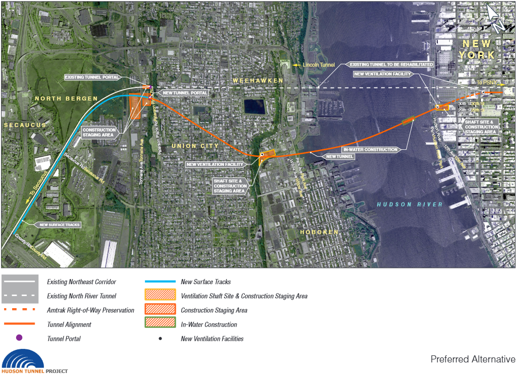


 and
and  in millions, of distance d kilometers, is,

 hours, is empirical in Japan. But then it is clear, from
