This is a close second option in a poll I conducted among my Patreon backers. Thanks to everyone who participated. The winning option, about branching and transfers, I covered last week.
Modernizing commuter rail to run it like rapid transit means a lot of things. It means high all-day frequency, fare integration, good transfers to local transit (which requires fare integration), and ideally through-running in order to hit multiple business districts. In North America, these are absent, resulting in low ridership. So let’s posit that these problems are already being solved: commuter rail is being run frequently, the lines are electrified, the fares are the same as on local transit with free transfers. What should the stop pattern look like? This is not a purely hypothetical discussion, because in Toronto the under-construction RER system includes high off-peak frequency, electrification, and through-running, with fare integration under consideration.
So let’s imagine a city with modernized regional rail, maybe in the early 2020s. Trains run every 15 minutes off-peak, charge the same fare as local transit, and run fast EMUs, on track that’s good for 130 km/h outside station throats. The stop pattern, expressed in kilometers out of city center, is any of the following:
| Line |
Stop #1 |
Stop #2 |
Stop #3 |
Stop #4 |
Stop #5 |
Stop #6 |
| Chicago Metra Electric |
1.3 |
2.3 |
3.6 |
4.3 |
5.2 |
9.5 |
| Chicago UP-North |
4.5 |
10.5 |
15.1 |
17.7 |
19.3 |
21.4 |
| GO Transit Lakeshore West |
3.2 |
10.8 |
15.4 |
20.6 |
26.9 |
34.4 |
| GO Transit Lakeshore East |
8.4 |
13.8 |
17.1 |
20.3 |
26.6 |
33.6 |
| SEPTA Paoli/Thorndale Line (PRR Main Line) |
8.7 |
9.7 |
10.9 |
11.9 |
13.7 |
13.7 |
| Metrolink Antelope Valley Line |
9.3 |
17.5 |
24.9 |
35.4 |
48.3 |
55.1 |
| Metrolink Orange County Line |
14.4 |
27.1 |
35.2 |
41.3 |
50.2 |
53.5 |
(Metrolink data comes from measuring on Google Earth, the rest comes from Wikipedia.)
Two patterns emerge:
- Metrolink and GO Transit have very wide stop spacing. GO has straight track it owns outright on the Lakeshore lines, and Metrolink is straight with few curves on the Orange County Line (but freight owns much of the route) and straight until stop #4 on the Antelope Valley Line, Sylmar. EMUs could average 90 km/h on these lines, counting schedule padding.
- SEPTA and Metra have wide stop spacing in the core but very narrow spacing in the suburbs; I discussed this issue for Metra in an old post comparing its stop distribution through stop #12 with that of the RER. Metra Electric has a few inner stops, e.g. for the convention center (stop #4), but then there’s a 4-km gap from stop #5 to stop #6 (Kenwood).
Both patterns are compatible with modernized rail operations. But both have problems with dealing with passenger demand. Consider what happens to a transit user in Burbank (stop #2 on Antelope Valley), or Ravenswood on the North Side of Chicago (stop #2 on UP-North), or Danforth and Main (stop #1 on Lakeshore East). Such a passenger would get an incredibly fast train to the CBD, running either nonstop or with one stop. Demand would boom. But is this really the most efficient way of running transit? Not really. This is for the following reasons:
- The downstream locations would still be very attractive infill train stations, with potential for high ridership. After all, they’d get fast service, too.
- If you get a 1-stop, 10-minute train ride to work, then adding four more stops to turn it into a 15-minute ride sounds like an imposition (it raises trip times by 50%), but it really isn’t, because most likely your actual commute is 30 minutes, with 10 minutes of walking at each end.
- With fare integration, buses should really be feeding the major train stations. Making every bus feed a small number of stations with fast commuter rail service compromises the rest of the network, whereas siting train stations at the intersections with the major grid buses in cities like Toronto, Chicago, and Los Angeles facilitates transfers better.
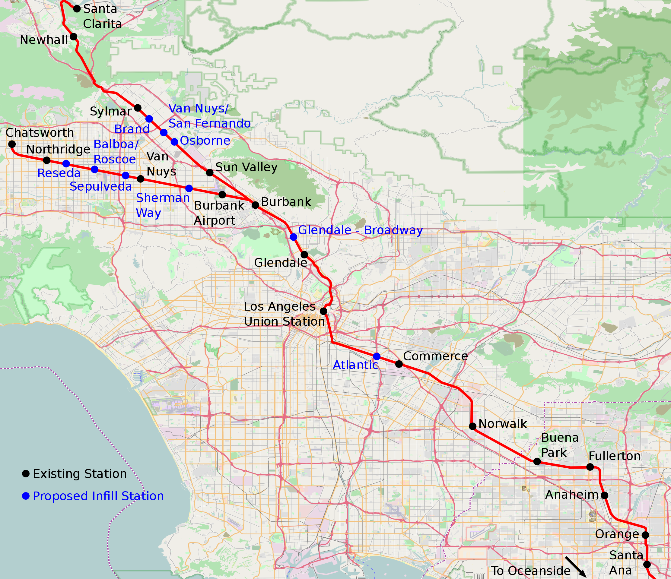
As a result of these principles, my proposal for Electrolink in Los Angeles, built out of the Antelope Valley and Orange County Line, involves extensive infill stops. See map below:

I drew even more extensive (and somewhat fanciful) maps for Los Angeles and Chicago, with more infill, but I want to focus on my Electrolink map, because it showcases some caveats.
Of note, there is much more infill on the Antelope Valley and Ventura County Lines than on the Orange County Line. This is because there is less residential density near the Orange County Line, and much more industrial land use. Los Angeles has a strong manufacturing sector, using the railroad for freight access, so residential upzoning near potential infill station locations is speculative. In the San Fernando Valley the land use near the railroads is not great, but there is a decent amount of residential density beyond the near-railroad industrial uses, there are strong bus corridors intersecting the railroads (and potential for light rail); the corridors also have less freight, so it’s easier to kick out industrial uses from station sites and do residential and commercial upzoning.
In New York and Boston, there are other caveats, explaining why my various regional rail proposals for these cities call only for mild infill. The biggest caveat is that there exist parallel subway lines. Boston’s Old Colony trunk passes through relatively dense areas in Dorchester and Quincy, with just three stops: JFK/UMass at km-point 3.7, Quincy at km-point 12.7, Braintree at km-point 17.6. But the Red Line runs parallel to the trunk making more stops, enabling commuter rail to work as an express overlay. Thus, only the busiest locations deserve a commuter rail stop, and those are precisely the three existing stops. In Somerville, the Green Line Extension plays a similar role, providing local service that commuter rail would otherwise have to provide under any modernization scheme. As a result, my proposal for how to run the Old Colony Lines and the Lowell Line through Somerville is more intercity rail than local commuter rail.
In contrast, the Worcester Line has no parallel subway except on the innermost few km, so it’s already getting two infill stops (Boston Landing and West Station) and I’ve called for several more. The same is true of the Fairmount Line, which is expanding from five stops including the endpoints to nine.
There is an analog for this in Paris, on the RER. Within the city and La Defense, the RER A mostly runs as an express overlay for Metro Line 1, stopping at the major stations, omitting just Bastille, which is too close to Gare de Lyon. But the RER B really has two separate stop regimes. North of Chatelet, parallel to Line 4, it expresses to Gare du Nord, and then doesn’t stop again until reaching the suburbs. But south of Chatelet, all trains make 5 stops in 5 km to Cite-Universitaire, even ones that run express in the suburbs; this is the older part of the line, much of which predates the Metro, so Line 4 was built along a different alignment via Gare Montparnasse.
In New York, the commuter trunks going north and east are closely parallel to the subway, which is often four-tracked. Since the subway already provides relatively fast service, with stops every 2-3 km, commuter rail should be even faster, with sparser stops. The principles here are,
- Infill stops are more justified at intersections with major orthogonal bus or rail corridors or in dense, transit-deprived areas. Areas with little residential development are to be categorized based on redevelopment potential.
- Infill stops are less justified parallel to a subway line. The faster the subway is, the faster commuter rail should be.
- Infill stops are more justified on a shorter line than on a longer line. Here, “shorter” and “longer” do not mean the length of the line to the endpoint, but the length to the endpoint of local service, if the infill stops would not be served by express trains.
Metro-North is parallel to the four-track Lexington Avenue Line, which has four tracks. Between 125th Street and Grand Central, the 4 and 5 trains make just two intermediate stops, at 86th and 59th Streets. Metro-North runs nonstop between 125th and Grand Central, and because the 4 and 5 exist, it has no reason to make more stops, even at 59th for additional service to Midtown
In the Bronx the trunk line isn’t so close to the subway, but already makes multiple stops. There may be plausible infill in Morrisania between Melrose and Tremont. But even that is marginal – for one, Melrose, Tremont, and Fordham are all located at the intersections with high-ridership east-west bus routes, whereas nothing in between is. This distinction between an inner and outer part of the same line also holds for the Atlantic Branch: west of Broadway Junction it parallels the four-track A/C, so no infill is needed, but farther east it parallels the slower J/Z and isn’t even that close to the subway, so infill is useful.
Going east, the LIRR Main Line is parallel to the Queens Boulevard Line, like the Lex a four-track line. There is no real point in infill, except at Sunnyside Junction, where the line meets the Northeast Corridor. The Port Washington Branch is a shorter line than anything on the Main Line, even the Hempstead Branch (but not by much), and isn’t as close to the 7 as the Main Line is to the Queens Boulevard Line; the 7 is also slower. This means an infill stop or two may be justified – my map has three (at Queens Boulevard, Broadway, and Junction), but that may be too much.
It’s the west direction that is the most speculative, toward New Jersey. I have called for new Hudson tunnels to feature a station at Bergenline (building a station in the existing tunnels would disrupt current service and slow down express trains) based on the above principles. Additional infill is possible, but only subject to transit-oriented development plans alongside the line. The land use from just west of Bergen Hill, including Bergenline, to just east of Newark, is a combination of industrial warehouses and wetland preserves. The warehouses should be redeveloped, but until there is rezoning, it is pointless to add more stops. Moreover, Secaucus Junction is already in the middle of the warehouse area, so rezoning should start from there, and if the newly-built residential neighborhood grows big enough so as to justify a second station, a second station can be added later.
The upshot is that even though New York has very wide stop spacing on commuter rail near the core, it does not need as much infill as Los Angeles or Chicago. What about Toronto, the original impetus for the post? There, Metrolinx is already considering minor infill. But if the principles emerging from how I think about infill in the US and on the RER are correct, Toronto needs far more infill. The Lakeshore lines are not really close to the subway: they run east-west, as does the Bloor-Danforth Line, but Lakeshore West is about 2 km from Bloor, and Lakeshore East is mostly 1 km from Danforth, with just a short segment within walking distance. The inner areas of Lakeshore West are very dense, with some blocks at 30,000 people per km^2, and only served by buses and slow mixed-traffic streetcars; even some areas along Lakeshore East are fairly dense, more than 10,000/km^2. Toronto’s bus and streetcar grid hits or can be extended to hit several potential station locations, offering better connections than riding to the Bloor-Danforth Line and then changing to Yonge to reach the CBD.
The one drawback in Toronto: the commuter lines are very long. Not all trains have to make all stops, but if there’s one stopping pattern making 3 stops in 15 km and another making 12, then it isn’t really possible to mix them on the same tracks at high frequency. The core lines have four tracks, but Lakeshore needs to eventually mix four classes of trains: local commuter rail, longer-range commuter rail, intercity rail, freight. There are ways around four-way mixture (for example, there is little freight on Lakeshore in Toronto proper, where the local trains would run), and intercity trains can probably share tracks with long-range commuter trains. It’s solvable, just like the three-way track-sharing between local, express, and eventual high-speed trains around New York, but it isn’t trivial.
In general, North American commuter trains make too few stops in the urban core. Tellingly, while I can come up with many examples of lines that require infill, I can’t name five good examples of anti-infill, where a station served by commuter trains full-time should be closed. But not all commuter lines are equally good candidates for infill stops, and there are large networks, such as Metro-North, where the current stop spacing is fine, just as there are ones, such as GO Transit and some Metra lines, where some inner segments could plausible see the number of stops quadruple.


