Difficult Urban Geography Part 2: Hilly Topography
This is the second and last part of a series about difficult urban geography for public transit, following a Patreon poll. Part 1 covers narrow streets.
A few years ago, Sandy Johnston remarked that Jerusalem had the least gridded street network he ever saw, and this complicates any surface transit planning there. At the time he was familiar with New England already, but Jerusalem seemed different.
Here are street maps of West Jerusalem and Boston, at the same scale:

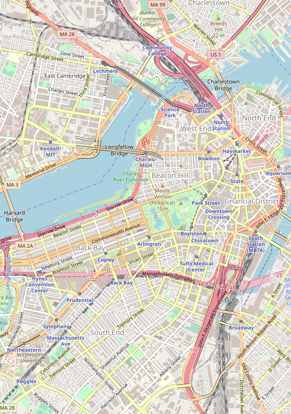
Boston has some gridded sub-areas, like Back Bay, but Downtown Boston is as messy as Jerusalem, and on the level of arterial streets, even the rest of the city isn’t too different. The real issue affecting Jerusalem is the hilly topography. Once one gets out of the core of West Jerusalem, the city turns into a mess of hills with internal street networks and poor connectivity between them. Boston maintains a coherent structure of arterial streets that host buses and tramways, with a cobweb structure that feeds the subway efficiently; in Jerusalem, there is little chance of that.
Surface vs. rapid transit
Rapid transit is mostly insensitive to hills. A subway can be built across hills, partly underground, partly elevated. This is the case in Upper Manhattan, where the 1 train runs in a mix of cut-and-cover subway, elevated structures, and mined deep-level tunnel.
Even if the hills slope down into the natural arterial, this is not such a problem. Train stations can incorporate escalator access and have exits at different elevations. New York manages this in the same neighborhood where the 1 runs, in Washington Heights, on the A train. Monaco, on a sloping hill, manages the same at its train station, which is located underground, using elevator access from multiple neighborhoods at different altitudes.
The deep mining required for such construction doesn’t even raise costs that much. If it’s possible to secure horizontal access to the station site, construction becomes easier. Moreover, running elevated through the valleys, as the 1 does in Manhattan Valley and Inwood, cuts costs rather than increasing them.
Evidently, the hilliness of Rome has not prevented the city from building a subway. Line C’s construction costs were very high, but not because of topography but because of millennia-old archeology, which is not really a question of the street network.
Since rapid transit is not affected as much by hills as surface transit, a city with hilly topography should be biased toward rapid transit and against surface transit. This does not mean every flat city should be content with surface transit and every steep city should build subways and els, but it does mean that the population and density thresholds for rapid transit are smaller in hillier cities.
Pod development
Some cities are very hilly, but this does not affect their street networks. San Francisco is famous for this: north of Market, in neighborhoods like Telegraph Hill and Russian Hill, the street grid continues mostly uninterrupted, and the result is famously steep streets. In these cities, transit network planning need not pay much attention to the topography: the only concession that need be made is that agencies should preferentially electrify and run trolleybuses, which have better hill-climbing performance than diesel buses – as San Francisco Muni in fact has, retaining trolleybuses rather than replacing them with diesels as nearly all other American cities have.
The more interesting and difficult case is when the street network respects the hills. It can naturally turn the city’s street layout into that of multiple distinct pods, each surrounding a different hill. This is popular in Jerusalem, especially the settlements within East Jerusalem, but also in some of the newer parts of West Jerusalem. There is not much connectivity between these different pods: there may be a single arterial road with the rest of the city, as is the case for the settlements of Pisgat Ze’ev, Ramot, and Ramat Shlomo.
This kind of pod development is popular in a lot of auto-oriented suburbia. The cul-de-sac is a defining feature of many an American suburb. However, in Jerusalem we see it happen even in the context of a dense city: Jerusalem proper has a density of 7,200 people per square kilometer, and all the settlements in question are within the jurisdiction of the city. It comes out of a combination of modernist central planning (Israeli neighborhoods and cities are designed top-down, rather than expanding piecemeal as in North America or France) and the hilly terrain.
Transit planning for such a city is a chore. In theory, choke points are good for transit, because they have high intensity of travel, where dedicated lanes can make buses very efficient. In practice, choke points work for transit only when there are coherent corridors on both sides for the buses to feed. For example, on a wide river spanned by few bridges, buses can run on the bridges, and then continue on the arterials feeding them on either side. Pod development, in contrast, has no coherent arterials within each pod, just collector roads feeding the main drag. Buses can still run on these streets, but there is no structure to the density that encourages them to serve particular locations and not others.
One solution is a type of transit that is overused in flatter cities: the direct express bus, or open BRT. This bus runs local within each pod and then continues on the arterial, making few stops; it could run as open BRT if the arterial has enough development to justify such service, or as a nonstop express service if it is a full freeway. This form of transit developed for both low-density American suburbia and Israeli pod development towns (where this is buttressed by the tendency of the ultra-Orthodox to travel in large families, in which case transfer penalties are much higher, encouraging low-frequency direct service).
Another solution is to go in the air. Gondola lifts are seeing increasing use in extremely hilly cities, where surface transit must wend its way through switchbacks. Medellin’s Metrocable has a vertical rise of 400 meters. Even in cities that are less steep, gondolas could be a solution if arterial roads are simply not available. In the Arab neighborhoods of East Jerusalem, arterials are rarely available, and gondolas bridging ravines could be of use. Gondolas could also be useful for neighborhoods that are only connected by arterial in a radial rather than circumferential direction – they could again bridge ravines to connect peripheral neighborhoods to one another rather than just to the center.

Your concept of “pod development” in Jerusalem reminds me of the gated communities of SoCal, and of fractals, where paths feed off main trucks. The idea of bus service feeding into dedicated bus lanes on the main arterial roads is a great idea. However, I’m not sure how useful connecting different pods directly by gondola would be; in fractal cities, services cluster on the main branches, and residents rarely have a need to go into other residential pods except for the occasional social visit.
Mi Teleférico in the La Paz/El Alto area (pop. over 1.5M) is a very new and still expanding gondola system that seems vastly more extensive than anywhere else. The two main cities are separated vertically by 400-500 m, and much of the road network looks terrible for surface transit due to topography. Their website doesn’t seem to list fares, but allegedly it is integrated with the bus network so meant for locals and not just tourists. Probably too early, but if anyone has some good numbers from this I’d be interested.
The map of West Jerusalem does not look too hopeless as the enclaves are pretty small, and as there are clear major roads that could be the basis for transit. As long as you accept that most people will have a 5-800 meter walk to the nearest main transit stop, running frequent buses on bus lanes or light rail on those streets should be able to provide acceptable transit, as an alternative to car ownership. Once such a robust network is in frame, commercial development will naturally orient itself around those corridors and transit stops (as long as planning is somewhat flexible), something Jerusalem seems to currently completely lack. Buses also deal with hills pretty well.
I dont have to much knowledge about West Jerusalem (and I have only visited during Shabbat…) but I assume that density also is decent, and large groups don’t use cars. In general, the problem seems mainly to be that development has been car-oriented for too long (due to elite preferences I assume), but as density seems reasonable, the situation is probably solvable unlike less dense (both FAR-wise, and inhabitant/dwelling) US-sprawl.
Hong Kong Island is very very hilly, and until very recently the western part of the Island that is both very dense (and has the most curvy road grid), managed completely by bus, with virtually zero car-ownership. In general, hilly areas have always been served very poorly by transit in Hong Kong. The solution is that high demand makes many things are accessible very nearby and that people walk quite a bit
I read that HK has a plan to install hundreds of outdoor escalators and elevators to improve access to those areas which are all over the territory. Inspired by the Central-Mid-levels escalator that climbs 135m up the Peak, often claimed as the longest escalator in the world but not really, in that it is a series of escalators as you’d want, so as to serve all the apartment buildings en route.
Back in 2011 you translated an article on the Jerusalem light rail written by Shalom Boguslavsky. You wrote at the time “I translated it because it’s important to showcase the politics of transit and there’s a dearth of good English-language analysis of Israeli transportation,” but that the views were Boguslavsky’s and not necessarily yours.
In any case, Boguslavsky’s complaint was that the light rail line, after reaching Jaffa Street from the west, continued north along Sderot Bar-Lev, rather than looping around the southern part of the city back to near its starting point. I disagree with Boguslavsky and think, rather, that a more or less straight, not too steep, wide road leading right up to the gates of the Old City was a godsend for people planning a light rail line through Jerusalem – which has the problems you describe here – and that building a city’s first rail transit line as a loop would generally be a bad idea. Do you have any thoughts on the topic?
here is a map of projected future lines. The blue line will do about what he suggests. There is no reason these need to be a single line.
You say that rapid transit is a good way of dealing with hills, but I think that is limited.
If you have a large flat area with a single hill in the middle, you can run rapid transit in a tunnel through the hill, with a stop under the hill accessed by elevators. In fact you don’t need rapid transit for this; you can put a single tunnel in an otherwise surface-running light rail line; Portland did this in Washington Park, and Jerusalem is planning it for its Blue Line light rail line (though this may secretly be due to desire to avoid ultra-Orthodox demonstrators blocking the route, more than actual difficulty of the terrain in that area). This can still provide inferior service to a surface line in a flat area (if the area is hilly enough that raching the elevator portal is a chore), and it relies on the elevators being maintained reliably, but all in all it works reasonably well.
However, if you have to serve two large areas at different altitudes, things are more complicated. Trains cannot easily climb steep grades. Naples’ Metro Line 1 seems to use an underground spiral to climb the altitude difference more gradually. Many cities have funicular railways which easily deal with grades, but which require you to transfer from the regular train. One transfer is OK, but if you have to do transit-funicular-transit then the transfers are a major chore which deters ridership (i.e. Haifa’s Carmelit funicular).
One system that does solve the problem very elegantly is Lyon’s Metro Line C. It’s a regular metro, but for the one very steep part a rack railway system has been installed so it can go up/down at an incline of 17 degrees. I have wondered how many other locations this would be a good and affordable solution for. La Paz/El Alto and Haifa come to mind. Without a rack, the steepest metro I have found is Lausanne M2, which manages 12 degree inclines on regular rubber tires.
I’m not sure “Pod” layout is inherently so bad. Take away the altitude differences, and it gives a “radial sector” city layout like Stockholm’s, where there are radial development corridors extending from the city center, each one centered on a transit line, with parkland in between them. What altitude differences do is reduce the practical walkshed from a transit stop. This decreases the effectiveness of any form of transit by a similar amount. The one counter-measure I can think of is to run main routes along the central corridor of the pod, along with minibus feeder routes providing transfers to the main routes. Healthy active people can walk to the main route and save themselves the transfer, while less active people (or anyone when it’s raining) will wait for the feeder bus – so you get the best of both worlds, to a limited extent.
Actually, the line in Lausanne started as a funicular, then got converted into a cog railroad (LO, Lausanne – Ouchy). The lower part of the M2 métro is using the LO right of way; the upper part is completely new.
The situation with the Lyon line C is kind of similar; it started out as a funicular which got converted and expanded as a cog railroad. Later on, adhesion only stretches got added.
Another urban cog railroad is the Dolderbahn in Zürich, which also started as a funicular, and got converted (and extended a little bit) in the 1970s
The point is, funiculars cannot cover a long distance with flat or up-and-down segments, and passengers tend not to tolerate transfers to/from short funicular lines. So Lausanne and Lyon tore out their funiculars and replaced them with technologies that could handle both hills and long distances. Other hilly cities should consider using Lyon’s or Lausanne’s technologies from the beginning.
If there is a part 3, it might be interesting to look at Stuttgart, which is a very hilly city. Over the last 40 years or so, they converted the extensive streetcar network to a “Stadtbahn” network. Many people still miss the very scenic street running section up to the Fernsehturm, which got replaced with a tunnel. Stuttgart also has an urban cog railroad (which came to my mind only after posting my comment to Eric, above). This line originated as cog railroad (opposed to other similar lines starting as funiculars).
Stuttgart has rather dirty air due to being down in a circular-ish valley.
And it is way ttoo car oriented… I mean they have the Mercedes star on the main station…
Seattle is similar to San Fransisco (steep hills has lead to a lot of wire powered buses). Of course, relatively cheap (and clean) electricity also played a part. I would say there are a couple other related challenges for Seattle. First is that a lot of the streets were laid out to follow the prevailing hills, which were basically north-south. Some of the east-west streets are not only steep, but narrow, as they are considered relatively minor. If you look at a transit map of Seattle (https://seattletransitmap.com/app/) you can see that Ballard (in northwest Seattle) has a pretty good grid (as good as anywhere in the city). But there is a pretty big gap between east-west bus service. It would make sense to run a bus on 65th NW, connecting reasonably densely populated neighborhoods. Except that would be very difficult, given the narrowness of the street. I think it will likely wait until self powered transit vans become common (which hopefully will be fairly soon).
Another issue is man-made barriers. Your mention of a gondola reminded me of a proposal to connect South Lake Union with Capitol Hill. This is an area separated by both a steep hill and I-5. This would make a gondola (or a subway) more appealing than it would otherwise. Any time you make transit operate differently than surface travel you are bound to attract more riders.
Cincinnati’s inclines lifted streetcars with the passengers still in them. No transfer for the rider. Applicable anywhere today? I have no idea.
Wouldn’t digging in a city like Jerusalem be all kinds of messy what with everything being holy ground?
They’re already digging up the holy grounds! Lots of archeological digs by various religious groups, mostly trying to prove that the city really belongs to them. Nobody coordinates anything. The area culture has engineering achievements like the Maccabiah Bridge and the Pal-Kal method. If a holy site collapses into the ground, it may well be overzealous digging rather than terrorism, not that the adherents of the faith in question won’t use it as an excuse to start WW3.