Intercity Rail Routes into Boston
People I respect are asking me about alternative routes for intercity trains into Boston. So let me explain why everything going into the city from points south should run to South Station via Providence and not via alternative inland routes such as Worcester or a new carved-up route via Woonsocket.
As an explanation, here is a map of the region’s commuter rail network; additional stations we’re proposing for regional rail are in turquoise, and new line segments are dashed.
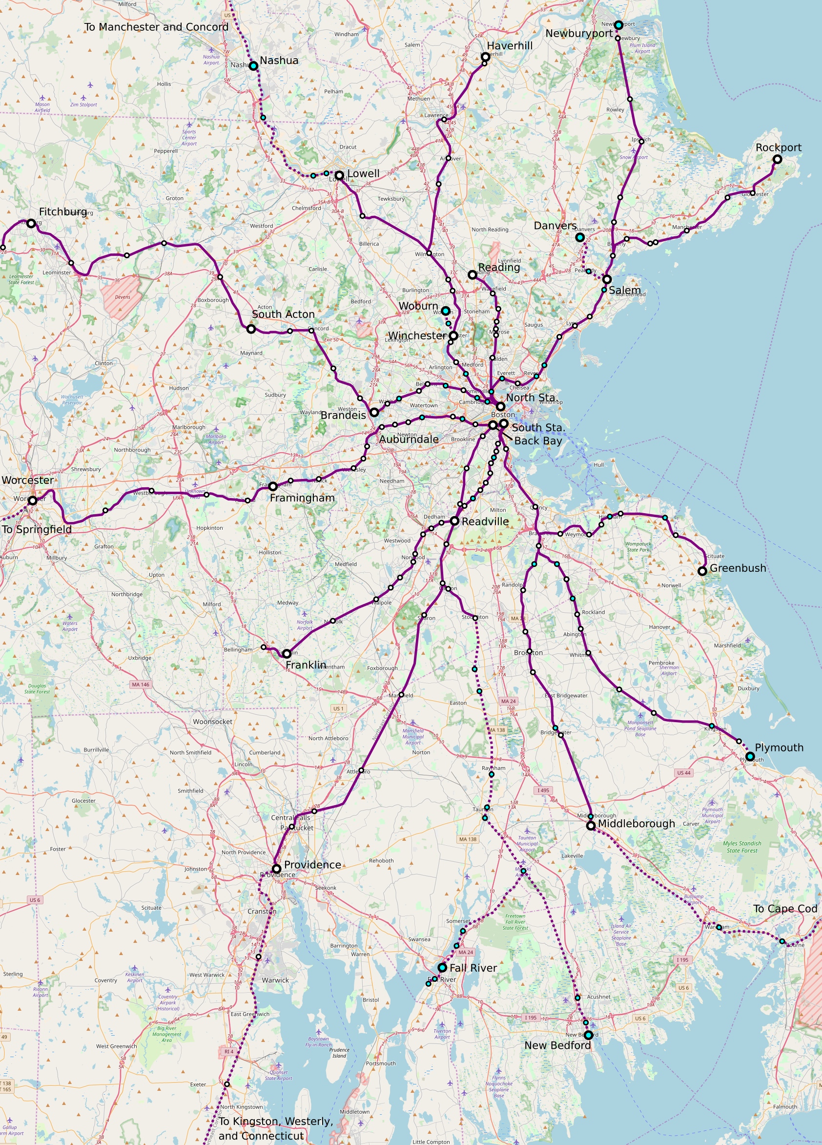
Observe that the Providence Line, the route currently used by all intercity trains except the daily Lake Shore Limited, is pretty straight – most of it is good for 300+ km/h as far as track geometry goes. The Canton Viaduct near that Canton Junction station is a 1,746 meter radius curve, good for 237 km/h with active suspension or 216 km/h with the best non-tilting European practice. This straightness continues into Rhode Island, separated by a handful of curves that are to some extent fixable through Pawtucket. The fastest segment of the Acela train today is there, in Massachusetts and Rhode Island.
The Worcester Line is visibly a lot curvier. Only two segments allow 160 km/h running in our regional rail schedules, around Westborough and immediately west of Grafton. This is why, ignoring intercity rail, our timetables have Boston-Providence trains taking 47 minutes where Boston-Worcester express trains take 45 minutes with 4 fewer stops or 57 minutes with 5 more, over the same route length. And the higher the necessary top speed, the larger the trip time mismatch is due to curves.
Going around the curves of the Worcester Line is possible, if high-speed rail gets a bypass next to I-90. However, this introduces three problems:
- More construction is needed, on the order of 210 km between Auburndale and New Haven compared with only 120 between Kingston and New Haven.
- Bypass tracks can’t serve the built-up area of Worcester, since I-90 passes well to its south. A peripheral station is possible but requires an extension of the commuter rail network to work well. Springfield and Hartford are both easy to serve at city center, but if only those two centers are servable, this throws away the advantage of the inland route over Providence in connecting to more medium-size intermediate cities.
- The two-track section through Newton remains the stuff of nightmares. There is no room to widen the right-of-way, and yet it is a buys section of the line, where it is barely possible to fit express regional rail alongside local trains, let alone intercity trains. Fast intercity trains would require a long tunnel, or demolition of two freeway lanes.
There’s the occasional plan to run intercity rail via the Worcester Line anyway. This is usually justified on grounds of resiliency (i.e. building too much infrastructure and running it unreliably), or price discrimination (charging less for lower-speed, higher-cost trains), or sheer crayoning (a stop in Springfield, without any integration with the rest of the system). All of these justifications are excuses; regional trains connecting Boston with Springfield and Springfield with New Haven are great, but the intercity corridor should, at all levels of investment, remain the Northeast Corridor, via Providence.
The issue is that, even without high-speed rail, the capacity and high track quality are on Providence. Then, as investment levels increase, it’s always easier to upgrade that route. The 120 km of high-speed bypass between New Haven and Kingston cost around $3-3.5 billion at latter-day European costs, save around 25 minutes relative to best practice, and open the door to more frequent regional service between New Haven and Kingston on the legacy Shore Line alongside high-speed intercity rail on the bypass. This is organizationally easy spending – not much coordination is required with other railroads, unlike the situation between New Haven and Wilmington with continuous track sharing with commuter lines.
If more capacity is required, adding strategic bypasses to the Providence Line is organizationally on the easy side for intercity-commuter rail track sharing (the Boston network is a simple diagram without too much weird branching). There’s a bypass at Attleboro today; without further bypasses, intercity trains can do Boston-Attleboro in 11 fewer minutes than regional trains if both classes run every 15 minutes, which work out to 25 minutes per our schedule and around 32 between Boston and Providence. To run intercity trains faster, in around 22 minutes, a second bypass is needed, in the Route 128-Readville area, but that is constructible at limited cost. If trains are desired more than very 15 minutes, then a) further four-tracking is feasible, and b) an intercity railroad that fills a full-length train every 15 minutes prints money and can afford to invest more.
This system of investment doesn’t work via the inland route. It’s too curvy, and the bypasses required to make it work are longer and more complex to build due to the hilly terrain. Then there’s the world-of-pain segment through Newton; in contrast, the New Haven-Kingston bypass can be built zero-tunnel. But that’s fine! The Northeast Corridor’s plenty upgradable, the inland route is bad for long-distance traffic (again, regional traffic is fine) but thankfully unnecessary.

One historical question if known: Why is there no connection between South Station and North Station? Seems that lines that serve one do not serve the other except Brandeis and Auburndale which seem to be very close. Very curious. Are there any plans in the works to connect the two terminals or is there no good reason, infeasible, etc?
There is a plan – it’s called the North-South Rail Link and is very good, it’s just that our Regional Rail plan is for what to do in advance of it.
N-S rail link is way too expensive to ever be built. And Amtrak doesn’t have enough trains to justify
There used be a historical freight rail link between North Station and South Station. It shut down (presumably) because during the 20th century trucking freight became more common.
Multiple rail terminals in a city is common, and through running passenger trains in the city center didn’t really become popular until the mid/late 20th century and after widespread electrification. By the mid/late-20th century the US was no longer rail powerhouse, and even today MBTA Commuter Rail is not electrified.
Except when people, back in the 19th Century, determined that having multiple railroad stations was silly and smooshed them all together.
https://en.wikipedia.org/wiki/Union_Station
Except union stations are the reason why Boston has North Station and South Station, instead of many more.
According to Wikipedia Amtrak runs through Union Station Springfield and through Union Station Worcester. And through Union Station Little Rock Arkansas and Union Station Texarkana Texas or Arkansas and ….
Again, according to WIkipedia North Station was the consolidation of railroad terminals, opening in 1894. South Station 1899. Both 19th century years. Feel free to go through the list on Wikipedia and find the last one. Very likely sometime around 100 years ago which would be “early” 20th Century.
> According to Wikipedia Amtrak runs through Union Station Springfield and through Union Station Worcester. And through Union Station Little Rock Arkansas and Union Station Texarkana Texas or Arkansas and ….
Which matters why? Are you arguing on the technicality that the trains go through? The stations those union stations replaced weren’t terminals anyways, since those cities were stops along a line that connected two more important cities, that probably had primarily terminal stations, possibly union stations, similar to Boston North Station and Boston South Station.
NSRL more resembles an S-Bahn tunnel than any typical 19th century project, which wouldn’t become popular until the mid/late 20th century. The idea of South Station passenger trains running through to/past North Station wasn’t even implemented, even when there were freight tracks linking the two, since the idea at the time was you took the train to one of Boston’s terminals, then took the streetcar/etc. to your final destination.
> Again, according to WIkipedia North Station was the consolidation of railroad terminals, opening in 1894. South Station 1899. Both 19th century years. Feel free to go through the list on Wikipedia and find the last one. Very likely sometime around 100 years ago which would be “early” 20th Century.
i.e., union stations are literally why Boston has North Station and South Station, instead of many more.
> Except when people, back in the 19th Century, determined that having multiple railroad stations was silly and smooshed them all together.
So…when did the people of New York City collectively do this? There’s still 3 separate commuter terminals (Penn, GCT, Hoboken), and Metro-North isn’t going to grace Penn on one side only till decade’s end at the earliest. Until the end-1950’s there were SEVEN such terminals lining the Hudson fragmenting all manner of travel by RR company…a half-century longer than it took Boston to tame their glut down to 2. Until 1969 run-thru practically didn’t exist at Penn because nearly all intercity trains were a forced transfer between PRR and NYNH&H trains. There wasn’t even a unified Amtrak intercity ticket office anywhere in the region until the Empire Connection opened to Penn in 1991. There still isn’t any Major Investment Study conducted by any pan-NYC governing bodies on real run-thru commuter rail to/from Jersey or Long Island. Say what you will about the funding chances of Boston’s NSRL, it’s at least been officially and immaculately studied and ops-modeled over the last 25+ years and is fully conceptually fleshed-out.
What a garbage cite. Union stations were anything-but-‘figured out’ in purely olden times. Wake me when the second largest city in the Western Hemisphere has got theirs more than halfway sorted.
Another poster child for fragmented stations is Chicago, which has 5 separate downtown passenger stations (although 2 of them are on the same line), and is actively working on a project to shift trains out of Union Station into LaSalle St. Station. And unlike NYC or Boston, there’s a pretty decent chance you’re going to be riding over or under one of the approaches to another station.
There is life outside of Boston, Manhattan and Chicago. Which is why there is an extensive list of places called “Union Station”.
The list of major industrialized cities of the 19th to early 20th century world is not that extensive though, and in those there’s a pretty obvious trend of terminal stations, often multiple, at least until the mid/late 20th century. Of those cities (the ones which Boston is more comparable to, than Texarkana), there are plenty of cities like London and Paris with multiple rail terminals that remain terminal today, and plenty of cities like Philadelphia which linked up and through ran its multiple rail terminals in the mid/late 20th century.
Move the goalposts.
Baltimore and Philadelphia had steam through service. We are still using the tunnel from 1873 in Baltimore. The B&O was going to out compete the PRR and gave Baltimore and Philadelphia a second through service route.
Before the union stations were built, there were 4 competing railroads on the northside (Boston & Maine, Boston & Lowell, Fitchburg RR, Eastern RR) and 4 on the southside (Boston & Providence, Boston & Albany, New York & New England RR, Old Colony RR) who each had their own separate depots. Too much cat-herding amongst RR barons to fashion any thru connections; most of their political and business capital got expended just in getting the North Union Station and South Union Station compacts set up over the last decades of the 19th c. There was a single-track freight line that ran street-running on Atlantic Ave. between the union stations that was intact until about 1960 strictly for serving local businesses, but it was a somewhat harrowing journey through mixed street traffic so was only used at night for local deliveries with all thru freight interchanging in the suburbs instead. And from 1901-1938 there was the Atlantic Ave. El rapid transit line (appendage to the present-day Orange Line) providing a passenger shuttle between terminals. But the El drew most of its initial ridership from the ferry wharves not the railroads, so once the cross-Harbor ferries were largely displaced by automobiles there wasn’t enough shuttle ridership left to sustain it through the Depression.
Northside got all-unified under Boston & Maine ownership through aggressive consolidation by about 1900, so North Station was conveniently all under one management. And indeed, there was some early conceptual planning for a proto- North-South Rail Link done in the 1910’s and 1920’s when the RR’s were at their pre-Depression peak. Southside, however, remained somewhat ownership-fragmented with New York, New Haven & Hartford (consolidated B&P, NYNE + Old Colony) and New York Central (B&A) managing South Station through a somewhat weak-scope holding trust all the way until 1969. Their business partnership was never strong enough to do much coordinated planning, so that’s where most of the 20th Century slipped past.
It then took the state until 1976 to consolidate ownership of both halves of the system, so pretty much all serious NSRL planning and conceptualization has been in the modern era post-1980 when it was pitched as a component of the Big Dig.
I don’t know but have ALWAYS wondered why this very thing! Especially for someone elderly, disabled, or with limited English, getting across the city is very difficult. Daunting. For example, I live North of Boston, can get to North Station, but if my destination is Providence, Worcester, Springfield– all of which I may have reasons to go to, and NOT drive– I have to get to South Station. Prior to my knee replacement, I was pretty disabled, had to use a cane, not walk far, stairs were extremely challenging- so got a taste of these difficulties during that time.
Purposed branch to Woburn doesn’t appear to have existing ROW.
Is the branch planned to be built underground, at grade or elevated?
There is existing ROW, there was a branch to Woburn back in the 1800s and its route is sorta kinda mostly intact. I don’t know if this plan has advanced past the transit nerd fever dream stage, however.
The ROW in Woburn is mostly intact but there are parts that are either in use by other businesses and if they were to make it not a dead end spur it would need a way to get past 95. I dont think theres a tunnel or anything else to connect the two halves of the ROW.
It’s not. The MBTA sold the property back to the towns of Winchester and Woburn some decades ago (one of the only such cases where the state didn’t landbank the property for a former hold), and the towns reverted the property lines back to local abutters. You can see on Google Maps map view by zooming in that in Winchester the property lines are a total crazy quilt, while Woburn still has some choppy intact sections of unknown affinity. There’s a couple instances of outright physical obstruction now, but mainly it’s the utter legal nightmare of trying to stitch contiguous property back together that kills the re-use potential.
The line was also a grade crossing nightmare back when it was still in operation (pre-1981), particularly where it S-curves through dead-center Downtown Woburn with close-spaced, very bad-angled crossings. Any service restoration done as RR or light rail addendum off the Green Line Extension would probably have to stub-out several blocks south of City Hall to trim a few of the worst crossings, limiting its utility a little. And it wouldn’t exactly be a fast jaunt on the rest given quantity of crossings.
Downtown Woburn is easy enough to incorporate on transit if you added a Lowell Line infill at the ex-Boston & Maine “Montvale” stop (https://goo.gl/maps/mgYFWeXvQ3PFTVQg9). Then pulse up the bus frequencies from Montvale on MBTA Route 354 and from Winchester Center on MBTA Route 134 and all of Woburn’s density ends up well-covered. The Montvale infill’s been proposed many times before, just never advanced to any sort of formal planning. Adding it should be made an ironclad requirement of Regional Rail-ification.
FWIW…the proposed branch to Danvers (the portion past the Peabody Square intermediate stop) is also a nonstarter. Town of Danvers has already signed the rail trail lease for the MBTA ROW that turns north of the active tracks at Peabody Square and runs to Danversport, so that’ll all be a paved hiking path within about 3 years. There’s another landbanked ROW available straight west out of Peabody Sq. to Route 128 @ North Shore Mall that can be used instead, and a study 15 years ago benchmarked it out to roughly equal cost and ridership to the Danversport option (to the point where a third “do both” option ended up getting a rundown in the study). City of Peabody currently owns that landbanked ROW as a power line trunk for its municipal electric utility, but is on the record saying they’d willingly sell it to the state for rail reactivation (while rejecting any/all rail trail proposals next to their muni power lines). So adjust that portion of the map accordingly, as it’s 99.9% likely to be taking the North Shore Mall ROW out of the Square rather than the Danversport ROW.
Working-class Peabody has always been staunchly pro-rail and badly wants this extension, while tonier Danvers still has NIMBY pockets and wanted its hiking trail instead. They’ll still have good enough transit access if pulsed-up bus frequencies out of Danvers meet up with Regional Rail @ Peabody Sq. and/or the mainline @ Salem, but they long ago made up their minds to reject ever hosting it themselves.
Hey Alon, enjoy your commentary. Don’t forget grade crossings, there are a material number along the Worcester line that would need to be addressed if true HSR were to be implemented.
It’s not that many. Springfield-Boston has only 4 public crossings total, and a small handful of least-concern private/limited-liability crossings. The two prominent ones in Framingham are a car (but not train) traffic clog and might not be eliminable without a Chinese-wall three-pronged viaduct that City of Framingham residents will surely reject. But so long as they get weapons-grade crossing protection (quadrant gates, lane barriers, security fencing) that pair is not impactful to train schedules, since every train on every schedule of the whole service layer cake is making a station stop at adjoining Framingham Station. They’re no more impactful to train schedules than the two uneliminable ferry dock crossings in New London on the NEC that are both on Coast Guard evacuation routes for trucking out vessels pulled from the water.
The other two public crossings in Ashland are a fairly easy elimination with a rail overpass of Main St. and a half-over/dip-under of Cherry St., a setup Town of Ashland long ago threw its support behind. The only concession there is you wouldn’t be able to reanimate the historic downtown Ashland Depot as the preferred town commuter rail stop over the presently inefficient parking sink located west of Downtown because the downtown depot location would be mid-incline (not exactly a make-or-break consideration since the parking sink stop has lots of room for improvement). For private crossings the work is limited to a 3-for-1 combining of 3 consecutive driveways in Wilbraham with very minor frontage work…then weighing whether a road-over-rail overpass is truly necessary on the last one (I doubt it is unless you’re envisioning something way denser than regional schedules out here). The only others are one extreme seldom-used power line service driveway in Grafton (can probably be blocked off entirely), a single private home driveway in Palmer, and a single farm tractor crossing between two fields in Palmer…stuff where speeds are not impacted at all because all safety liability is shouldered by the private abutters.
Springfield-Albany has scattered public crossings…very widely scattered in MA, somewhat more clustered west of the NY state line. But those don’t matter unless you first figure out the more manifold challenges of doing 125+ MPH through the Berkshire grades and curves. They won’t rate as concerns until you’ve tackled the prerequisite geological challenges. Hartford-Springfield-Boston Inland Route can be fully sealed excepting the Framingham pair, and it’s a realistic enough reach to shoot for even for mid-speed regional service. Most of the crossing remainders on that corridor are on the Springfield Line in CT, not the B&A in MA.
If the train is going to make it to Albany in hour it can’t be stopping at every commuter station. If it is going to not-stop there it doesn’t have to not-stop between the platforms.
Framingham has always been an intercity stop, because Boston’s MetroWest region is too big a draw to ever outright skip and Framingham carves out its de facto most accessible midpoint. Framingham is a stop on the Lake Shore Limited, it was a stop on the prior incarnation of the Inland Route Northeast Regionals until 2004, and it’s proposed to be a stop again on the Inland in all studied service permutations in both the East-West and NNEIRI studies. No one has ever called for taking a nonstop flying leap from South Station to Worcester Union Station, just as no one has ever made a drunken bar bet that “Albany in an hour” is somehow the be-all/end-all wagging the dog for this corridor. Please stop polluting the comments with these non-sequiturs.
There can be trains that make lots of stops and trains that don’t.
New Haven is roughly as far from Boston as Albany is. I haven’t suggested Albany in an hour. Other people have. If it doesn’t make it to Albany in about an hour it can’t make to Toronto or Montreal fast enough to make those destinations attractive. Just like if the train doesn’t make it to New Haven in around an hour it can’t make it to Baltimore or D.C. fast enough.
…..There is the Amtrak iteration of HSR for Boston that manages to miss everything except Hartford.
There are five destinations from Boston. Portland, Montreal and beyond. Albany and beyond. Hartford. New Haven and beyond. Two make sense. Albany and New Haven.
There’s enough demand between New England and the places with lots of people to have two routes out of Boston.
Montreal is pretty bullshit, the direct route is mountainous as fuck and has nothing in between; the actually buildable Boston-Montreal route goes via Albany and where you live. Then there’s Portland, which is nice and also smol.
Now, Boston-Albany via HSR is nice and all but it’s a) way down the priority list from the NEC, and b) still not going to get Boston-New Haven to be faster via Shin-Worcester and Springfield than via Providence.
Silly me. RouteS got me confused. Seems to five of them to me. If you wanted to focus on the route with the highest demand, be bold and title the post differently.
The easier and therefore cheaper route from Boston to New York and beyond is through Providence. According to old railroad timetables via Hartford, Springfield and Worcester is slightly shorter. It wasn’t faster. The shortest route misses everything except New Haven.
That doesn’t change that there appears to be five destinations from Boston. Or that two of them make sense when the real world intrudes. Someday far far in the future, someone starting out in metro Worcester can wend their way to Shin Worcester out on the Turnpike and take a train through Springfield and Hartford to get to New Haven and beyond. Or to Albany and beyond.
…. If you are starting out in East Boston, flying to Cleveland looks good. If you are starting out …… anyplace else… a high speed train might be faster. When I looked at destinations a few years ago there were two very expensive non-stops, weekdays. from Hartford/Bradley to Cleveland and none from Providence. Boston to Cleveland is roughly the same distance as Kansas City to Denver. The tunnels and viaducts from Boston to Utica are going to be very expensive. The only thing between Kansas City and Denver is Topeka. Which has a smaller MSA than Worcester, Hartford, Albany, Syracuse, Rochester or Buffalo. Or Erie Pennsylvania. Or Utica.
Worcester, Springfield, Albany, Utica, Syracuse, Rochester, Buffalo makes more sense than almost anything foamers can come up with other than the NEC. Powerfully expensive but serves a lot more people than Denver to Salt Lake City ever will. Or Louisville to Atlanta. Or… There are a lot of people in New England. There can be two routes. Partly because the primary demand across the Northeast, Midwest, Southeast and half of Canda’s population is for New York City and the tracks west or north of Albany will be there anyway. Much more sense to spend lots of money in the Northeast than fantasize about high speed rail from Portland Oregon to Sacramento California.
I’ve think their argument here was whether or not to focus on the Providence line or the Worcester line for highest-speed, highest-frequency rail. Other posts from Alon on rail in the northeast have included a high-speed line out of Boston towards Albany (and then Buffalo, Cleveland, Chicago, etc.), but this is rail at ~200kmh to Worcester, not built to potentially ~350kmh standards, with less frequent service–most significantly, implying a less-straight route west out of Boston is acceptable, at least until west of Worcester, where it’s too curvy for high speeds and would require more extensive tunneling.
Worcester and Springfield combined have more people than Providence. Now, Providence is a bigger *urban center* than either, but the sheer population is still relevant. No argument that the existing NEC should be the first priority for any *HSR* investment, but it’s not clear why there should be *no* investment in Worcester-New Haven-NEC service that, while slower, provides a one seat ride, which is more important at intercity scale, when you have an anchor as strong as New York.
The lack of a bypass doesn’t seem all that relevant with respect to running standard speed rail; the scheduling is more complex with three service patterns, but this is possible on other two track lines, no?
Lower-speed intercity services exist everywhere and do well, so I don’t see a great justification for the “HSR or nothing” mindset.
There absolutely should be such investment. But.
1. Through-riders from New Haven to Boston will ride on the faster Shore Line, so this is really about intermediate city pairs, esp. Hartford-Boston.
2. Timetabling three different service classes on one track pair through Newton is hard at high frequency. In general, it’s the most frequent service that sets the limit, so as soon as it’s established that Newton gets 4 tph, everything else has to fit in pretty narrow slots.
The upshot of both of these issues is that timetabling the New Haven-Springfield-Boston trains should be centered on less express patterns – the benefit of high speed (where high speed means “like Boston-Hyannis RR,” not actual HSR) is reduced since the typical trip is shorter, and the cost of high speed is increased because Newton is that painful.
That’s why I keep thinking in terms of timetables that treat Boston-Springfield as just an ordinary Boston-Worcester RR train that goes further. It’s possible to maybe do a third option, but I’m skeptical about its benefit-cost ratio.
Depends on how fast the train gets to New Haven or Springfield. Hartford is closer to Springfield than it is to New Haven. And Springfield is closet to Boston than New Haven is. If New England wants to piggyback on all the all the tracks in New York that are there for New York to Montreal and New York to Toronto it makes sense to spend a lot of money to make Boston-Albany reallllllly fast.
Is there merit for united frequency on different lines? Like the trains to New York from Boston through shore line will depart on ’15 and ’45 while the trains to New York from Boston through Hartford depart on ’00 and ’30, so that anyone travelling between Boston and New York can get 15 minutes headway and the earlier train can still arrive earlier than the later train despite might be a few minutes slower, while also capturing all the demands in-between
Unless someone wants to build a tunnel from Springfield to New Haven the Inland Route is going to be somewhat slower.
How much slower? 10min slower could give a 10min—20min interval at one end and a 20min—10min interval at the other end.
Assuming very high speed between Boston and Albany using an improved line through Hartford would add 20 around minutes between New Haven and Boston.
It will be okay if there are trains that only stop in Baltimore, Philadelphia, Jamaica, New Haven and Providence before arriving in Boston. And the one after that making more stops. And the one after that making all intercity stops. There’s enough demand to do that. And it’s okay if the train that goes from Boston to Philadelphia stops in Bridgeport, Stamford, New Rochelle, New York, Newark, Bound Brook , Landsdale, Wayne Junction, Jefferson, Suburban and terminates at 30th Street.
It’s not BART.
My big question: where would folks slot this type of regional rail / inter-city upgrades in terms of transit priorities for the Boston area? Looking at the T, it looks both super-radial and poorly connected in the central city (e.g. Blue Line doesn’t connect to Red in the downtown core). Also, close in neighbourhoods like Revere, Malden, Everett in the north, and South End, Roxbury and Matterpan south of the city look underserviced by rapid transit. Better regional rail would help some of this, but T extensions or new lines would also hit some of these underserved areas. Is there a need for more radial rapid transit (don’t know what mode would work) to service cross town trips? If we had better costs controls and bigger budget, we could do lots at once, but what’s the biggest need?
This gets at a bigger question critical to North America in general: should we focus on Regional services (that hit mostly suburbs) or close the holes closer in, where this is more demand?? For my money, North America is overly focused on suburban services.
I don’t know the Boston – Providence – Worcester region well enough to comment on this proposal’s technical / connectivity merits. Keep up the good work, though.
Boston needs to walk and chew gum at the same time. It needs BOTH a robust Regional Railification and a breakneck buildout of the rapid transit system. Red-Blue Connector, the Urban Ring radial, conversion of the Seaport Silver Line BRT tunnel into a thru-running Green Line LRT appendage from Downtown, and the Blue Line extension to Lynn are all general-consensus big urgencies right alongside Regional Rail and NSRL.
In the specific case of BLX-Lynn that’s true even with a partial service overlap with Regional Rail through Lynn. Because the North Shore’s travel orientation tilts much more strongly to the Blue Line via the densest parts of Revere and East Boston rather than the Eastern Route’s jaunt through a lot of empty swamp to Chelsea and Everett, the entire local bus network doesn’t work right unless it’s direct-hubbed with rapid transit. Right now that entails buses duplicating themselves en masse from Lynn to Wonderland for the Blue connection, wasting equipment cycles in the withering traffic on that leg, and creating a gradually worsening frequency anemia to the last-mile points of the North Shore because of all that very inefficient equipment cycling structurally starving the return in outlying frequencies. Regional Rail to Lynn/Salem by its lonesome doesn’t divert enough of that bus loading the way the destination pie is divided for that region, so the whole North Shore really needs both rapid transit and good solid Regional Rail hubbing with buses at a Lynn megaterminal in order to fully realize the region’s enormous potential transit shares. Doing Regional Rail as an implicit cop-out for not doing BLX would be an incredible disservice to that region’s long-term needs, and it always dismays me to see the occasional transit advocate buy into that fallacious reasoning. If anything both projects COMPEL each other in a big way.
There’s that, and the traffic-reshaping effects of the North-South Rail Link are so vast and unpredictable as to how they’d change the loading of the current subways that it’s almost ironclad that you MUST have better radial distribution on rapid transit to keep the whole works from choking on its own growth. For every Orange Line where NSRL run-thru Regional Rail might lighten the overall load a little bit there’s a Red Line where already bad overcrowding might get an order-of-magnitude even worse from the new suburban ridership sources complete Regional Railification would entail. So the NSRL megaproject doesn’t live in its own modal vacuum, either…there will be many rapid transit dependencies exploited which will need their own major investments pronto. In the case Alon referred to of converting the Needham Line to rapid transit (Orange Line to West Roxbury, Green Line spur Newton Highlands-Needham Junction), Regional Rail wholly creates the rapid transit dependency because expunging the Needham Line from the innermost NEC is the only practical way to enable the expanded Providence/Stoughton Regional Rail frequencies on that congested stretch of NEC.
Very much an “AND”, not “EITHER/OR” set of questions re: across-board build priorities.
Any political support and/ or cash set aside for any of these projects? Sounds like an enormous need for more transit – everywhere.
Subway extensions: no, except maybe thee Red-Blue Connector, which is very short.
Boston-Springfield rail: yes, it’s called East-West and is backed by Western Mass interests; our assumption is that it will be funded together with Regional Rail to spread money across the entire state, which can be done right (with electrification, integrated takt timetabling, refusal to take shit from CSX on exactions, etc.) or wrong (2 diesel roundtrips per day, genuflection before CSX demands).
Would a route to Springfield be an extension of the Framingham / Worcester service? Or something different?
So from ‘F-Line to Dudley’s’ post, some priorities:
* Blue Line north to Lynn – seems really useful.
* Red-Blue connector – low hanging fruit.
* Urban ring circumferential – ambitious, but likely very valuable. Do most folks see it as a full ring on the eastern (harbour / airport) side? OR is there consensus among the advocate community beyond the concept? (Personally it seems more valuable to the west, but again, I’m looking at this from my desktop!!)
* Green line eastward taking over some portions of the Silver Line BRT – how might this interact with the ring route discussion above?
* Regional Rail – electricify, extend, upgrade the existing commuter rail with much more frequent service all across Boston/ Worcester/ Providence (e.g. something more like the RER in Paris)
*N/S Rail Link – allow through running between the two stations. Seems like low hanging fruit.
* Green Line into Summerville is underway, closing a hole close to the core.
To my eye, that sill leaves some holes, especially closer in to the city, that might be filled by a more ‘urban’ approach than Regional Rail. Curious what people think of these:
* Everett/ Chelsea – seems like a big urban gap. Someone pitched a Blue Line branch here, seems valuable.
* South Boston – would a radial subway ring help plug this into the rapid transit network? Could a Green Line extension from Downtown into this neighbourhood make sense (a reverse branch I guess, or breaking the Green Line into two or more lines?)
* South End/ Nubian Square/ Mattapan – is an upgraded Regional Rail approach on the Fairmount and Franklin lines going to fill in this gap? Or would there be value in a T extension or new line as well?
* Watertown/ Nonatum/ Waltham/ Brandeis U – similar question as above – will upgrading to Regional Rail on Fitchburg and Farmingham / Worchester lines service this gap, or is there value in rapid transit in addition to Regional Rail?
* Arlington – enough people/ density to justify extending the Red Line?
* Rosalindale / Belevue Hill – same question, would it justify a T extension?
A lot of the above question depends on info I don’t easily have (densities, travel patterns, local transit) and bigger picture thinking on line spacing.
Cheers – Sean
RE: seangillis78. .
The Urban Ring wouldn’t be a full uni-lined circumferential. The north half has all readily available rail ROW and a couple of ready-made hook-in points to make it a part of a transformed Green Line LRT system…one that can fling patterns on the ‘ring arcs’ straight from Downtown and also arc-to-arc as purer radial. But the southern half of the Ring is entirely on city streets and likely has to be BRT in its first incarnation since the only reasonable way to rail it would be mega-intensive/mega-expensive tunneling (and for mega-expensive tunneling it’s a very distant #2 priority to NSRL). Airport-South Boston also can’t be made a contiguous arc of the Ring because there’s no dedicated transit tunnel across the Harbor, only the route of the current Silver Line SL1 via mixed traffic through the I-90 tunnel, and it’s hard to maintain headways through all that dispatching uncertainty (SL3 to Chelsea via I-90 is a schedule crapshoot at the best of times). But the Urban Ring was never meant to be ridden as a complete or even half circuit, as it simply strings together a bunch of megaterminal transfer points where the ridership takes giant dumps at regular compass intervals. The reason for building it is that it links together some humongous bus terminals and shortcuts a lot of line transfers that currently have to take place in a gravitational singularity of 4 centermost-Downtown subway stations. Thus, it should provide enormous load relief for those Downtown transfers by siphoning sizeable numbers out to the fringes. The Ring halves would join at Kenmore Station upstairs/downstairs behind fare control, and each Ring quadrant would feature varied service patterns. There are also 2 spur routes–BU-Harvard Square on the Northwest quadrant and Melnea Cass-JFK/UMass on the Southeast quadrant–to further vary up the service blender.
Green Line taking over the Seaport is simply completing the missing link between the current BRT Silver Line Transitway and Downtown that was canceled 10 years ago because of projected cost blowouts in trying to build it at BRT dimensions under very narrow streets that caused the project to lose its recommended Fed funding rating. Silver Line was never designed to permanently terminate at South Station, and the overload it puts on the Red Line is slowly choking overall throughput as the Seaport explodes in growth. Completing the thru link to Downtown happens via a design re-route to easier-construction South End streets and changing the tunnel dimensions from BRT to LRT direct-address the blowouts that lost it the FTA rec rating the first time around. Higher-capacity LRV’s can then serve the bulk of the intra-Seaport travel much better than the very limited-capacity buses do today, doing much good to tame the platform dwell problems on the current Silver Line and the transfer swells Downtown on the Red and Orange Lines. The current Transitway tunnel was originally designed for compatibility with both buses and light rail, so can serve dual use after rails are laid in the pavement. SL1 buses for the Airport would then continue using the tunnel and looping at South Station as they do today while LRT trains would run thru from the disused outer tracks of Boylston Station on one end and take over the SL2 route loop in the Seaport on the other end. Though it’s designed for a separate purpose than the Urban Ring, there can indeed be some useful tangiental hook-ins to the the Ring. For example, the Ring Southeast-quadrant BRT from Nubian Sq. to South Boston can easily take up residence in the dual-mode Transitway as a South Station-looping BRT pattern, and one of the main LRT patterns can be a Seaport-originating train that runs Boylston-Lechmere on the Green Line thru Downtown before branching off to Chelsea/Airport on the Ring’s Northeast quadrant (meaning that from the South Station platform you could either/or a bus or trolley either direction for hitting Logan).
NSRL is not exactly “low-hanging fruit”. It’s going to cost billions to do, it has to exist on a very set trajectory deep below ground to swerve away from densely-packed other tunneled infrastructure, and the design requires station caverns that are 100+ feet below-ground meaning transfers upstairs/downstairs to/from rapid transit are not exactly going to be quick affairs. It’s not unlike East Side Access in overall complexity, and also mismanagement potential if they don’t do it right. But the payoffs are so stratospheric it’s without question worth every penny. Thru running “between stations” is such a drop-in-bucket compared to what it will overall transform in travel patterns across all of Eastern MA.
For the specific locations you ID’d. . .
— Everett/Chelsea — Urban Ring LRT is huge here for pooling transfer crowds. If you have alternating patterns switch off between running thru to Downtown via Lechmere and radially through Cambridge to Kendall Sq. and the universities you open up huge opportunities for these two working-class cities. The Downtowns of those two are not easy targets for linear subway extensions (a half-assed Orange Line reverse branch has kinda-sorta been studied for Everett, but is charitably eons from being buildable), so making their transfer lives easiest with robust radial/filet service at their doorstep is the priority first reach.
— Southie — They get their subway access if the Green Line is plugged directly into the existing Transitway tunnel via Boylston and Downtown. In addition to LRT’ing the SL2 loop route, an immediate target of Transitway Green Line service could be a full branch schedule pumped to City Point on a short amount of street-running track via Summer St. Bridge, helping load-relieve a couple very weighed-down local bus routes. As mentioned above, the south-half Urban Ring is easiest to mount as a BRT proposition because finding the wherewithal to rail-tunnel all of it under dense city streets is too far-future an ask…but the LRT and BRT service patterns that do run-thru to the souped-up Transitway can incorporate some radial as well as Downtown patterns to sweeten the pot.
— Nubian Sq. really needs an LRT branch to replace the Washington St. Silver Line. Incumbent BRT frequencies are pretty decent, but per-vehicle capacity is far too low for an outlying terminal as big as Nubian and the service doesn’t run behind prepayment to all of the big Downtown transfers. If you strengthen the spine to Nubian with thru-running Green Line, strengthen the radial network with Kenmore Nubian Southie Urban Ring BRT, then strengthen the Nubian Terminal outlying routes with more Key Route BRT (like they’re doing now with bus-only lanes on the 28) you strengthen the net greatly out here. Including where those to-be-improved outlying routes interface at the Fairmount Line Regional Rail stations. “Strengthen the net” is the buzzword out here more than any singular project.
— Newton/Watertown + Belmont/Waltham — Yes, you get enough of a generational boost with clock-facing 15-minute Regional Rail frequencies here to satiate most near-term growth. Rapid transit is going to be desirable someday, but the available expansion trajectories out here are much much further future so Regional Rail + a lot of bus network revamping are going to do a lot of heavy-lifting for the next 2 decades of growth.
— Arlington — Yes, they ultimately need the Red Line. It was never designed to stub out permanently at Alewife, and the northwesterly bus map is laid out all kinds of screwy because the canceled Arlington Center and Arlington Heights Red Line stops were to each be significant bus terminals. Arlington has recently shown much contrition for their past NIMBY’ism and now generally supports a Red extension (Lexington still not so, so Arlington Heights not Route 128 would be the terminus). I would say that this is not as five-alarm urgent as acute load-relieving stuff like the Urban Ring and Green-Seaport which explicitly keep the Core 4 Downtown transfer stops + Red Line-South Station from choking on their own 25-year growth…but RLX is a contender if Arlington’s newfound warmth to the idea percolates into louder activism the likes of which Somerville practiced with the Green Line Extension.
— Roslindale/West Roxbury — In the official TransitMatters Regional Rail manifesto, they advocate for rapid transit conversion of the Needham Line primarily for the sake of easier NEC dispatching of Providence/Stoughton trains. The Southwest Corridor tunnel/cut is unexpandable, so making the current 3 NEC tracks work for all future users at future frequencies means moving the Needham Line to another mode for sake of simplifying the NEC dispatching layer cake. Having an Orange Line stop at Roslindale would also do wonders for decongesting overloaded Forest Hills Terminal, where the bus network is oversaturated with route duplication to Rozzie Sq. and bus transfer swells frequently overwhelm the Orange Line platform. This one–consisting of an Orange Line extension to West Roxbury/VFW Parkway and a Green Line spur off the D Line at Newton Highlands to Needham Junction–is a relative cheapie since it would be outright displacing active Commuter Rail at the same stations on the same ROW. It may not carry the same *absolute* priority of an Urban Ring, Green-Seaport, or NSRL…but it has much short-term attractiveness for its price point and for the way it so nicely shotguns with Regional Rail-ification of the NEC.
Thanks – Good luck with the advocacy!
All the commuter rail lines need a connector line, a beltway train
This would not be a really heavy lift. There is existing track and stations Providence-Worcester-Ayer-Lowell-Lawrence, although the state controls very little of the track and I understand the Pan-Am territory track would need to essentially be completely replaced due to poor maintenance.
Infill stations in places like Woonsocket, RI and Clinton, MA could be added as future funding became available and advocacy picked up.
Going east of Providence to Taunton, Middleboro, even Wareham and Hyannis could be possible, but would require finding slots on the already congested NEC from Providence to Attleboro and its doubtful demand would warrant service east of Providence.
The section from the 2nd largest New England city (Worcester) to the 3rd largest (Providence) would probably draw the most demand and be the easiest part to justify.
Do they? Such a line would have low demand and thus low frequency (more people want to go suburb-downtown than suburb-suburb). Better to just have people transfer between lines downtown. Suburb-to-suburb connections can be handled with buses.
That was a reply to Norm
Massachusetts has a decent collection of suburban Regional Transit Authorities hubbing at the gateway city Commuter Rail stops (Worcester, Lowell, Lawrence, Brockton, Fitchburg, etc.), as well as a few key MBTA bus hubs inside the largely intra-Route 128 spanning MBTA bus district. Even Cape Cod has a fairly decent-for-its-density local bus system, so there’s basic coverage to tap even on Regional Rail lines without any heavily urbanized outlying areas. The RTA’s are all predictably skeletal in terms of frequencies outside of the absolute core urbanmost areas and a lot of the more rural adjoining towns have opted out of their nearest respective districts so there’s some territorial holes to plug with infills and route lengthenings past currently non-participating town borders. I wouldn’t exactly call it all useful everyday transit. But you can indeed–in “technically correct is best kind of correct” fashion–live car-free in a large swath of suburban/exurban MA today if you’re willing to contort your lifestyle a bit vs. the anemic source frequencies; it’s physically possible there where in a lot of other states (New Hampshire, for instance) it’s outright impossible because the service-providing entities don’t presently exist. So because the seeds and basic-most route structure are pre-existing it wouldn’t be an enormous undertaking to scale up the whole works on the RTA service side commensurate with the Regional Rail frequencies at the hubs to make it all truly useful transit. A whole lot of service- and fleet-side burnishing is required on the incumbent routes (some RTA’s more than others), but not a lot of facilities or intra-organizational buildup because most of that structure is pre-existing statewide.
Regional Railification needs to come attached with a “Marshall Plan” of sorts of suburban bus investment across the map to enable those crucial linked trips at frequencies that’ll truly drive transit shares. I wish those multimodal coattails were talked up more by the RER advocacies here, because developing those last-mile connections is such a very important component of the overall plan and nobody today is really giving that component all that much attention. It needs its own breakout conceptual development within the core RER ‘manifesto’ to get properly on people’s radar screens.
It would require some new bridges over the Charles & I-95 and some tunnel work to connect to the main line at Landsdowne, but looks much less painful than attempting to add a track through Newton.
Could Upgrading the D-Line to mixed-service heavy rail serve as a bypass to the 2 track pain in Newton? Both lines essentially meet at Landsdowne and Riverside and the alignment is double tracked (although to trolley (sub?)standards)
(I killed a duplicate comment.)
This is a great map, thank you!