Public Transportation in the Southeastern Margin of Brooklyn
Geographic Long Island’s north and south shores consist of series of coves, creeks, peninsulas, and barrier islands. Brooklyn and Queens, lying on the same island, are the same, and owing to the density of New York, those peninsulas are fully urbanized. In Southeastern Brooklyn, moreover, those peninsulas are residential and commercial rather than industrial, with extensive mid-20th century development. Going northeast along the water, those are the neighborhoods of Manhattan Beach, Gerritsen Beach, Mill Basin, Bergen Beach, Canarsie, Starrett City, and Spring Creek. The connections between them are weak, with no bridges over the creeks, and this affects their urbanism. What kind of public transportation solution is appropriate?
The current situation
The neighborhoods in the southeastern margin of Brooklyn and the southern margin of Queens (like Howard Beach) are disconnected from one another by creeks and bays; transportation arteries, all of which are currently streets rather than subway lines, go north and northwest toward city center. At the outermost margin, those neighborhoods are connected by car along the Shore Parkway, but there is no access by any other mode of transportation, and retrofitting such access would be difficult as the land use near the parkway is parkland and some auto-oriented malls with little to no opportunity for sprawl repair. The outermost street that connects these neighborhoods to one another is Flatlands, hosting the B6 and B82 buses, and if a connection onward to Howard Beach is desired, then one must go one major street farther from the water to Linden, hosting the B15.
For the purposes of this post, the study area will be in Brooklyn, bounded by Linden, the Triboro/IBX corridor, and Utica:
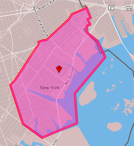
This is on net a bedroom community. In 2019, it had 85,427 employed residents and 39,382 jobs. Very few people both live and work in this area – only 4,005. This is an even smaller proportion than is typical in the city, where 8% of employed city residents work in the same community board they live in – the study zone is slightly smaller than Brooklyn Community Board 18, but CB 18 writ large also has a lower than average share of in-board workers.
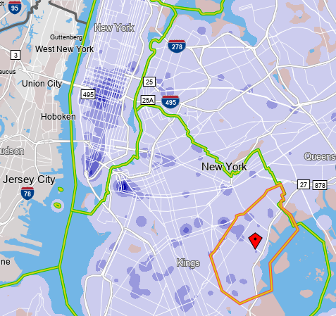
In contrast with the limited extent of in-zone work travel, nearly all employed zone residents, 76,534, work in the city as opposed to its suburbs (and 31,685 of the zone’s 39,382 jobs are held by city residents). Where they work looks like where city workers work in general, since the transportation system other than the Shore Parkway is so radial:
Within the zone, the southwestern areas, that is Mill Basin and Bergen Beach, are vaguely near Utica Avenue, hosting the B46 and hopefully in the future a subway line, first as an extension of the 4 train and later as an independent trunk line.
To the northeast, Canarsie, Starrett City, and Spring Creek are all far from the subway, and connect to it by dedicated buses to an outer subway station – see more details on the borough’s bus map. Canarsie is connected to the L subway station named after it by the B42, a short but high-productivity bus route, and to the 3 and 4 trains at Utica by the B17, also a high-productivity route. Starrett City does not have such strong dedicated buses: it is the outer terminus of the circumferential B82 (which is very strong), but its dedicated radial route, the B83 to Broadway Junction, is meandering and has slightly below-average ridership for its length. Spring Creek is the worst: it is a commercial rather than residential area, anchored by the Gateway Center mall, but the mall is served by buses entering it from the south and not the north, including the B83, the B84 to New Lots on the 3 (a half-hourly bus with practically no ridership), the rather weak B13 to Crescent Street and Ridgewood, and the Q8 to Jamaica.
The implications for bus design
The paucity of east-west throughfares in this area deeply impacts how bus redesign in Brooklyn ought to be done, and this proved important when Eric and I wrote our bus redesign proposal.
First, there are so few crossings between Brooklyn and Queens that the routes crossing between the two boroughs are constrained and can be handled separately. This means that it’s plausible to design separate bus networks for Brooklyn and Queens. In 2018 it was unclear whether they’d be designed separately or together; the MTA has since done them separately, which is the correct decision. The difficulty of crossings argues in favor of separation, and so does the difference in density pattern between the two boroughs: Brooklyn has fairly isotropic density thanks to high-density construction in Coney Island, which argues in favor of high uniform frequency borough-wide, whereas Queens grades to lower density toward the east, which argues in favor of more and less frequent routes depending on neighborhood details.
Second, the situation in Starrett City is unacceptable. This is an extremely poor, transit-dependent neighborhood, and right now its bus connections to the rest of the world are lacking. The B82 is a strong bus route but many rush hour buses only run from the L train west; at Starrett City, the frequency is a local bus every 10-12 minutes and another SBS bus every 10-12 minutes, never overlying to produce high base frequency. The B83 meanders and has low ridership accordingly; it should be combined with the B20 to produce a straight bus route going direct on Pennsylvania Avenue between Starrett City and Broadway Junction, offering neighborhood residents a more convenient connection to the subway.
Third, the situation in Spring Creek is unacceptable as well. Gateway Center is a recent development, dating only to 2002, long after the last major revision of Brooklyn buses. The bus network grew haphazardly to serve it, and does so from the wrong direction, forcing riders into a circuitous route. Only residents of Starrett City have any direct route to the mall, but whereas Starrett City has 5,724 employed residents (south of Flatlands), and Spring Creek has 4,980 workers, only 26 people commute from Starrett City to Spring Creek. It’s far more important to connect Spring Creek with the rest of the city, which means buses entering it from the north, not the south. Our bus redesign proposal does that with two routes: a B6/B82 extension making this and not Starrett City the eastern anchor, and a completely redone B13 going directly north from the mall to New Lots and thence hitting Euclid Avenue on the A/C and Crescent Street on the J/Z.
What about rail expansion?
New York should be looking at subway expansion, and not just Second Avenue Subway. Is subway expansion a good solution for the travel needs of this study zone?
For our purposes, we should start with the map of the existing subway system; the colors indicate deinterlining, but otherwise the system is exactly as it is today, save for a one-stop extension of the Eastern Parkway Line from New Lots to the existing railyard.

Starrett City does not lie on or near any obvious subway expansion; any rail there has to be a tram. But Canarsie is where any L extension would go – in fact, the Canarsie Line used to go there until it was curtailed to its current terminus in 1917, as the trains ran at-grade and grade-separating them in order to run third rail was considered impractically expensive. Likewise, extending the Eastern Parkway Line through the yard to Gateway Center is a natural expansion, running on Elton Street.
Both potential extensions should be considered on a cost per rider basis. In both cases, a big question is whether they can be built elevated – neither Rockaway Parkway nor Elton is an especially wide street most of the way, about 24 or 27 meters wide with 20-meter narrows. The Gateway extension would be around 1.3 km and the Canarsie one 1.8 km to Seaview Avenue or 2.3 km to the waterfront. These should cost around $250 million and $500 million respectively underground, and somewhat less elevated – I’m tempted to say elevated extensions are half as expensive, but this far out of city center, the underground premium should be lower, especially if cut-and-cover construction is viable, which it should be; let’s call it two-thirds as expensive above-ground.
Is there enough ridership to justify such expansion?
Let’s start with Canarsie, which has 28,515 employed residents between Flatlands and the water. Those workers mostly don’t work along the L, which manages to miss all of the city’s main job centers, but the L does have good connections to lines connecting to Downtown Brooklyn (A/C), Lower Manhattan (A/C again), and Midtown (4/5/6, N/Q/R/W, F/M, A/C/E). Moreover, the density within the neighborhood is uniform, and so many of the 28,515 are not really near where the subway would go – Rockaway/Flatlands, Rockaway/Avenue L, Rockaway/Seaview, and perhaps Belt Parkway for the waterfront. Within 500 meters of Rockaway/L and Rockaway/Seaview there are only 9,602 employed residents, but then it can be expected that nearly all would use the subway.
The B42 an B17 provide a lower limit to the potential ridership of a subway extension. The subway would literally replace the B42 and its roughly 4,000 weekday riders; nearly all of the 10,000 riders of the B17 would likely switch as well. What’s more, those buses were seeing decreases in ridership even before corona due to traffic and higher wages inducing people to switch away from buses – and in 2011, despite high unemployment, those two routes combined to 18,000 weekday riders.
If that’s the market, then $500 million/18,000 weekday riders is great and should be built.
Let’s look at Gateway now. Spring Creek has 4,980 workers, but first of all, only 3,513 live in the city. Their incomes are very low – of the 3,513, only 1,030, or 29%, earned as much as $40,000/year in 2019 – which makes even circuitous mass transit more competitive with cars. There’s a notable concentration of Spring Creek workers among people living vaguely near the 3/4 trains in Brooklyn, which may be explained by the bus connections; fortunately, there’s also a concentration among people living near the proposed IBX route in both Brooklyn and Queens.
The area is the opposite of a bedroom community, unlike the other areas within the study zone – only 1,114 employed people live in it. Going one block north of Flatlands boosts this to 1,923, but a block north of Flatlands it’s plausible to walk to a station at Linden at the existing railyard. 51% of the 1,114 and 54% of the 1,923 earn at least $40,000 a year. Beyond that, it’s hard to see where neighborhood residents work – nearly 40% work in the public sector and OnTheMap’s limitations are such that many of those are deemed to be working at Brooklyn Borough Hall regardless of their actual commute destination.
There’s non-work travel to such a big shopping center, but there are grounds to discount it. It’s grown around the Shore Parkway, and it’s likely that every shopper in the area who can afford a car drives in; in Germany, with generally good off-peak frequency and colocation of retail at train stations, the modal split for public transit is lower for shopping trips than for commutes to work or school. Such trips can boost a Gateway Center subway extension but they’re likely secondary, at least in the medium run.
The work travel to the mall is thankfully on the margin of good enough to justify a subway at $50,000/daily trip, itself a marginal cost. Much depends on IBX, which would help deliver passengers to nearby subway nodes, permitting such radial extensions to get more ridership.

I’m so glad someone is finally paying attention to this awfully neglected part of NYC. My parents live in Starrett City. It takes them a whole hour for them to visit my brother in Woodhaven, thanks to the meandering and often delayed B83, plus a transfer to the B42 on Atlantic. And that’s just over the border in Queens. Getting to Manhattan is a bus then a train, whether it’s the L, 3, A or J. Pennsylvania Avenue is a pedestrian nightmare, and could use some light rail, raised cross-walks, and protected bike lanes. As lovely and livable as Starrett was designed it be, it’s really built for cars, not people, and certainly not New Yorkers. I love all these suggestions here for the area!
Starrett City is the one where it’s hard to come up with a good subway expansion. But light rail should pencil out there if New York can get its construction costs even mildly under control…
Could an L branch off of the New Lots Ave station not make some sense? You’d have to do some taking to make the turn onto Linden, but Linden and Pennsylvania are such overbuilt, wide avenues that an elevated guideway would seem doable.
Hmmm, maybe?
Hmm, in fantasy land, you might have a 2nd Avenue-Utica Avenue line running down Utica Avenue, and have a branch of the IRT go on Remsen all the way down and turn east on Seaview Avenue. It would go east and over Fresh Creek, and hook north on Pennsylvania Avenue. I wouldn’t know the details of what parts would be underground/aboveground.
Or have the IRT branch off at Kings Highway after Sutter Avenue-Rutland Road station, and head south on Rockaway Parkway down to Seaview and east to Starrett City. No new portal would have to be built. The southbound track would split-off at grade while the northbound (Manhattan) track could use the unused middle track provision on the New Lots line to cross over the southbound tracks.
No, you can’t because there are people already using the L train.
The L has short enough headways that I think splitting service wouldn’t be very detrimental to the East 105th Street and Rockaway Parkway stations. There are already a number of trains that get short turned further north that could also potentially continue south with more rolling stock and a more efficient second southern terminal available.
Putting more people on the train east of Myrtle Ave doesn’t stop people from wanting to get on the train west of Myrtle Avenue.
Even an express bus that stops at Starrett, the 3 line, the A and J station, and maybe key transfer points (like Linden and Atlantic) would be amazing. It takes so damn long to get anywhere from Starrett. The B83 is awful. For the seniors in the area who need to go elsewhere for doctor’s visits it a lot. I know first hand from accompanying my parents on their trips. They don’t have a car and depend on the bus or taxi.
The B83 is just so circuitous and I have no idea why. Pennsylvania is right there…
More people live along Van Siclen Ave?
“I’m tempted to say elevated extensions are half as expensive, but this far out of city center, the underground premium should be lower”
I suspect the underground premium will be as high or higher, because these are low-lying area near the sea, where the water table is presumably high.
Is this an example showing that spreading out jobs cannot reduce commuting time?
As for transit and transpprtation on separated pockets of flat land along ocean or mountain…. Is there any general rules on this?
I’ve been doing some back-of-the-envelope thinking that suggests spreading out jobs actually worsens commuting time. (I should write this up somewhere…)
In an idealized model: consider a job center as the center of a circle. The radius of the circle is the amount of land reachable in a reasonable commute time. People are assigned to job centers at random, in proportion to the relative size of this job center; in reality many jobs will be correlated, but we can assume they’re independent for the sake of the model. In any case, the amount of housing available to the worker depends on the speed of transit (to make the radius bigger) and the density of the housing in the reachable area; and more job centers ought to mean accommodating more people without requiring increased density around any particular central hub.
All well and good. BUT most people do not live in single-person households… and when there are two employed persons, you actually get *two* circles, one centered around each of their respective job locations. The acceptable living area becomes restricted to the *overlap* of those two circles. The further apart their job centers are, the smaller the area where they can acceptably live; in the worst case, if their jobs are in opposite directions, they may have only a small lens-shaped slice. One or both may be forced to accept much longer commute times in order to still have any available housing locations at all.
Spreading out the employment centers creates a double whammy here. The more diffuse the jobs are, the higher the chance of two randomly chosen employers being geographically far apart. *But* overall, since the residents as a whole aren’t going to the same places or coming from the same places, there’s less ability to respond by increasing housing/services density and building faster forms of transit. The only option left is increasing sprawl as workers accept longer commutes–but that in turn requires more sprawl infrastructure (the diffuse jobs of people working in local shopping malls, local commercial centers, secondary employment districts for people who want to minimize the commuting time) and things just keep getting more spread out.
When there are lots of job people weed out the ones that are a long commute.
This is correct; in addition to its vicious cycle with housing and infrastructure patterns, job dispersion also reduces the efficiency of the labor market.
Those pesky employees bring their stomachs bladders and bowels with them. I suspect just ventilating and cooling the enormous office tower would be the immediate problem. Water supply and waste removal next. They all eventually starve to death because there wouldn’t be any farmers.
Only for relatively low skilled jobs. Higher skill works which need specific set of skills from workers are usually centered around a specific part of a metro area, like for example finance and consultation jobs are usually around a single largest CBD in a region. airport and ports related jobs, as well as relevant logistic facilities and related positions, are usually only available near runways and harbours. If your expertise is in handling ships but your home and other members of your family work or study in part of city that are far from coast line, then you either have to accept long commute to where you can find jobs to match your expertise, or to give up your expertise and restart your career all over again.
Maybe in your version of SimCity 1955. It’s not 1955 anymore.
How? Port staffs can now telework to control the port in remote?
Do you realize the days of longshoremen wrestling cargo nets of goods on and off ships passed long ago?
And they are replaced by more technical roles to control and maintain the machines that replaced them.
No they weren’t, containerization brought extraordinary productivity gains. The support staff can easily move their skills to another industry.
It should be pointed out that Starrett City is not actually “an extremely poor neighborhood”; it is not public housing. It is a middle-income housing cooperative similar to Co-op City in the Bronx. However, Starrett City has evolved into a NORC as its baby-boomer residents who moved in when it was built in the 1970s have retired and aged in place. The residential sections of Spring Creek/Gateway, on the other hand, are affordable housing constructed in the past two decades, after the shopping mall was constructed. Residents of Spring Creek/Gateway are much more likely to be working-age or children. As a result, even though Spring Creek and Starrett City have somewhat similar numbers of employed residents, Starrett City has a significantly larger population, since it has a larger population of older residents. Spring Creek/Gateway also has a psychiatric hospital that should also be taken in account for bus planning.
that many of those are deemed to be working at Brooklyn Borough Hall regardless of their actual commute destination.
It works that way for private employers, it’s just that it’s more difficult to see. The address on the records is the address where the mail goes, not the place people actually work.
The difference is that for public employees (I believe teachers?) this is an extreme trend – employment is dispersed but LEHD thinks it’s all in one place.
It happens with private employers too, it just that it’s not as obvious because there is a gazillion of them. For instance I register with a temp agency in Manhattan and they send me to Long Island City the address the computers have is in Manhattan. Or I’m a consultant. Temp agency work for people with fancy job titles. Whatever database they are looking at has those kinds of problems. Unless you want to geo-tag every employee it’s going to be there.
If you did geo-tag everyone you’d find out that repair people and sales people work all over the place. Delivery people.
The issues here are several. 1. There are no existing bridges, even light pedestrian bridges that could accommodate bikes, across these creeks & peninsulas like the paedegat or mill basin etc. If there were there would at least be some opportunity to crossover from area to area without going around the edges of boundaries. In addition I’m not sure why extension of subway lines are any favorable answers, unless elevators are installed it won’t be easily accessible to seniors, disabled, folks with strollers etc. The answers seem clear, build bridges over these waterways, use shuttle bus service where needed
All new subway stations are accessible even in New York.
Some pedestrian bridges would be cheap and a good idea.
An easier lift to start with would be building a station to the Pitken yard (extending the C train) and extending the 3 train to the Livonia yard. Each of these extensions would be inexpensive and would both serve area in need of transit and would allow for more development.
“nearly 40% work in the public sector and OnTheMap’s limitations are such that many of those are deemed to be working at Brooklyn Borough Hall regardless of their actual commute destination.”
There’s a caveat when working with data derived from the Longitudinal Employer-Household Dynamics (LEHD) census data. The employer location is frequently a headquarters address and not the actual work site. One such example is the Brooklyn Borough Hall area because much of NYC’s payroll operations are centralized there. It’s the address of record for income tax withholding, unemployment insurance, workers compensation, etc. filings. These filings are the basis for the LEHD’s employer location.
…. it’s where the mail goes, not the place people actually work….
I agree with you on the problem but not on the solution. I have been studying and making bus reroute proposals for Brooklyn for 50 years since my Columbia Masters Thesis on the subject I wrote in 1972. I was also head of the MTA’s Brooklyn Bus Redesign Program in 1981 and 1982. For one thing the B83 meanders like it does because the MTA refused in 1975 to operate a needed new north south route in East New York Andy the community reluctantly settled on the meandering as a compromise. That route is still needed today.
Regarding the Belt Parkway, much of it has been reconstructed with shoulders. I proposed several new bus routes to operate along the shoulders to be immune from traffic to and from JFK and also between Sheepshead Bay and the Rockaway cutting a 90+ minute trip to a 30 minute trip, but the MTA has shown no interest in such service improvements because they do not want to spend additional funds.
I won’t beat around the bush. Your proposals for Brooklyn would be disastrous. Here are my carefully thought out proposals based on fifty years of experience. The routes are in Appendix 2. https://onedrive.live.com/?authkey=%21AMuE4L4GieYCDX0&cid=27B4793AC6019868&id=27B4793AC6019868%21192&parId=27B4793AC6019868%21105&o=OneUp
Would you be willing to summarize the points where you differ (particularly those you regard as potentially disastrous) for those of us at home who won’t have a chance to read both lengthy whitepapers?
First of all, the proposal is not thought out. Routes end where there is way they can turn around. For example, the B68 cannot turn around anywhere near Brighton Beach Ave and Coney Island Ave. it must either go to Ocean Parkway or Corbin Place and count this with non-revenue miles is wasteful.
More important, no regard is paid to existing travel patterns with many trips now requiring one bus will now require three or four buses and multiple fares. For example anyone now using the B1 or B49 for Kingsborough College, will now require three buses.
The proposal also eliminates one way streets which will wreak havoc on traffic. All routes are shown as operating two ways on each street. There was a very good reason why 13th Avenue was paired with 14th Avenue. You can’t make believe Existing travel patterns do not exist and draw a system from scratch on a blank slate. It just doesn’t work.
In any good proposal more are helped than are hurt.
Why can’t the buses turn around somewhere different?
They would have to terminate a quarter or half mile from the shown terminus. This is also true for many other routes. This also greatly adds to the cost of operations Especially if it is non-revenue service.
The actual calculations for resource requirements do take loops into account even if not shown on the map, because they come from current bus trip times with speedups applied based on the observed impact of bus lanes, stop consolidation, and POP.
draw a system from scratch on a blank slate.
The transit geeks are good at scrawling their crayons in peculiar places. That doesn’t mean the poor widdle cars can’t be rearranged.
i like the proposals… also canarsie/flatbush residents have no easy way of getting to gateway mall by public transportion… it is practically in the same neighborhood…. how about extending the b103 bus route to go directly to the mall?…or at least further down flatlands to Elton Street…
Alon, but you are only considering bus speeds and bus travel times. You are ignoring increased travel times due to increased walking and increased transferring which increased bus frequencies do not compensate for. Therefore you are making travel more difficult, not easier.