High-Speed Rail Doesn’t Depend on Megaregions
On my Discord channel, I was reminded of the late-2000s work by some institutional American urbanists about the concept of megaregions. Wikipedia has a good summary of the late-2000s discourse on the subject. In short, there are linear ties across the East Coast from Boston to Washington (“BosWash”), with more or less continuous suburban development in between, and some urbanists tried to generalize this concept to other agglomerations of metropolitan areas, not usually successfully. The American work on this carved most of the country’s population into 10 or 11 megaregions, sometimes annexing portions of Canada, as in the Regional Plan Association’s America 2050 program:
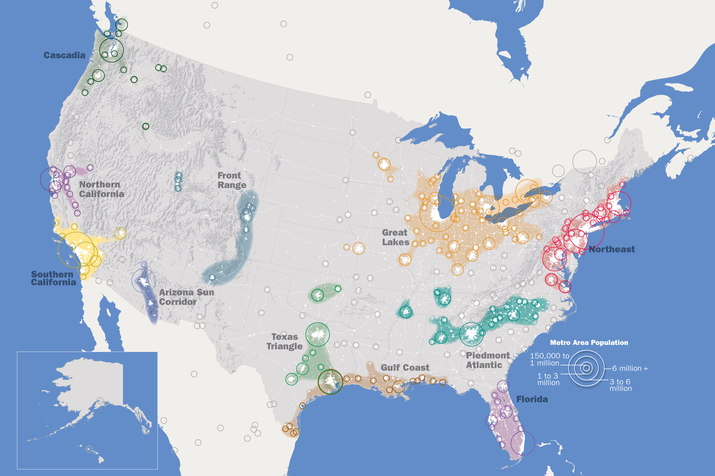
There is a lot to critique about this map. Canada has a strong self-conception as a distinct entity from the United States; while there’s a case for lumping Vancouver with Seattle and Portland as the Pacific Northwest, lumping Toronto with the Midwest is irresponsible. The Hampton Roads region is not meaningfully a periphery of the Northeast, but is rather Southern (for example, it is heavily militarized, and the South has consistently higher enlistment rates than the Northeast). The Rio Grande Valley is not especially connected with New Orleans.
But the core of the program is to propose this as the basis of high-speed rail investment, and that’s where it fails the most visibly. When one of my Discord channel participants posted the map in the channel about high-speed rail, I started talking about my gravity model, and pointed out some patterns that emerge.
For this, consult a table of ridership between any pair of American or Canadian cities in the main connected component of my proposed map:

The table omits Texas, California, and the Pacific Northwest. But it includes lines that I initially considered and rejected, going to Kansas City and Birmingham; the reason is that when I calculated it by hand I omitted very weak long-range connections such as between Boston and the Midwest, whereas the table can automatically calculate them and add them in, producing an estimate of 5 million annual riders between Boston and the entire Midwest region. These extra connections make weak lines like those to Birmingham and Kansas City appear stronger, so those lines are included; it’s plausible they could even justify a connection to Texas via both New Orleans and and Tulsa, but those are not included (and would at any case not impact the analysis below).
The following table includes some connections between two adjacent cities in the table, with their total projected passenger counts. Those are very high numbers, higher than you’d expect; this is because they lump in a great many city pairs – for example, New York-Philadelphia includes all connections from New York, Boston, and Albany to Philadelphia and points south and west, and those sum to a much higher number than just the internal trips on the Northeast Corridor, let alone just trips originating in New York and ending in Philadelphia or the reverse. Also, as a note of caution, there may be small inaccuracies if I mistakenly tabulated very weak markets like Chicago-Charlotte as going via the wrong path; they do not change the main conclusion.
| City pair | Ridership |
| Boston-New York | 39,299,133 |
| Boston-Springfield | 25,482,364 |
| New York-Philadelphia/Harrisburg | 139,860,707 |
| Philadelphia-Washington | 110,010,205 |
| Washington-Richmond | 64,145,050 |
| Richmond-Raleigh | 50,425,578 |
| Raleigh-Greensboro | 42,654,519 |
| New York-Albany | 57,773,629 |
| Philadelphia-Harrisburg | 65,639,871 |
| Harrisburg-Pittsburgh | 61,110,782 |
| Pittsburgh-Cleveland | 62,352,156 |
| Cleveland-Toledo | 56,482,182 |
| Cleveland-Columbus | 46,046,790 |
| Buffalo-Cleveland | 41,584,062 |
Some observations jump from this (partial) table:
- New York-Boston is much weaker than a lot of segments that are by themselves far weaker than the Northeast Corridor. The reason for this is that a full 31.1 million annual riders on New York-Boston are internal to the Northeast Corridor, whereas the other city pairs require large swaths of the network to be built to have such high traffic.
- From Philadelphia to points west, traffic density is fairly consistent. There’s no separation between a Northeastern and Midwestern megaregion evident in the data: Cleveland has about the same traffic density going east and west, as does Pittsburgh. Rather, it’s the connections between the East Coast and the Midwest, chiefly Philadelphia-Pittsburgh-Cleveland but also the Empire corridor between Albany and Cleveland, that create high ridership.
- Washington-Atlanta is a tail gradually weakening with distance from the Northeast Corridor, rather than an independent corridor.
Outside the US, the same observation about the irrelevance of megaregions to high-speed rail is true. The European attempt to describe a megaregion, the so-called Blue Banana, was constructed explicitly to exclude France – but the highest-traffic density intercity rail link in Europe is between Paris and the bifurcation splitting toward Lyon and Dijon. Frankfurt-Mannheim is a close second, but French intercity trains average around 220 km/h and German ones around 130 km/h depending on the line, and the actually existing high-speed rail network gets higher peak traffic density than the medium-speed one.
Ultimately, high-speed rail as a mode of transportation is a means of connecting metropolitan areas. Whether they fall into megaregions or not is immaterial – some strong links connect distinct regions, like Northeast-Midwest, with higher demand for traffic than some of the internal connections.

Reblogged this on Utopia, you are standing in it!.
The most valuable part of the megaregion classification, in my opinion, is to stop making people think “US have 300m people spreading all over the country thus HSR is impossible”, and instead give people a clear guidance pointing out where and how each regional centers can connect outward to different parts of the country, showing how the HSR can really realistically benefit residents around each megaregions which can end up covering most US residents, without falling for traps like advocating coast to coast line and claiming failure to do so would mean failure to the concept of HSR in the US.
Coast to coast at 100mph or so would still be a lot better than driving it.
But a lot worse than flying it, which is what people do.
HSR won’t work tomorrow where we don’t have sustainable passenger rail today.
Honestly I suspect half the reason HS2 isn’t great for the Thames valley is because people who live in the Thames valley and travel to the north drive whereas people who live in London currently catch the train (although to be fair Old Oak Common does help).
Same with the Low Countries/Britain to Spain/Italy express services I assert would get traffic. Well someone’s got to do them first and see what happens.
Alternatively, the megaregions map is a good first step at diverting attention from the dumb map towards Alon’s map.
“Classification” might be the wrong word, but yes, stop making people think there is an even distribution of people. *Most* of the people live in pretty areas. Even though most of Texas is sprawl, the vertices of that “triangle” are still pretty dense.
But to Mr Levy’s point, yeah, not much of a passenger train planning map.
The other thing that this helps people (who are willing to learn) understand is that there are not a lot of people in those non-mega-regions and that they have waaaaay to much power in Congress. 🙂
I’ve had the 2050 Mega Map (not MAGA Map) as my desktop image since I got my initial Macbook in ’12 … still my desktop image (because Time Machine is a thing when you get new hardware).
> *Most* of the people live in pretty areas.
“pretty colored areas on the map” Oy.
Related stat: population-weighted density. If you look at the density at which each country’s people actually live, the US is substantially denser than France or Germany. https://hub.worldpop.org/geodata/summary?id=50573 It varies by region, (lowest in the South & New England, highest in the Mid-Atlantic, Lakes, and West Coast) but mostly it is really very dense.
”
If you look at the density at which each country’s people actually live, the US is substantially denser than France or Germany.
”
Any perception that this is the case is purely a mistake on your part. Germany’s smaller than Iowa + Wisconsin put together. It has nearly 10 times as many people; 84 million vs 9 million.
The Netherlands is around the size of VT + NH but has 17 million people instead of 2 million. Most of Italy’s 60 million residents live in a 100 mile corridor that would in the US stretch from CA’s wine country to Tijuana. California only has 40 million residents.
I think the easiest way to motivate MAGA Republicans to build something like this would either be
a) say the military needs it
b) say something like “We have to prove that we are better than China and China already has an HSR network”
MAGA people are way too populist to have consistent opinions about technical issues and vote based on them. In 2009-10, Gingrich was making a populist pitch for a maglev network, which he said would be faster than the conventional HSR the Obama administration was looking at; then in 2010-1, thanks to some Tea Party governor oneupmanship, this turned into scorched earth opposition to rail investment.
Indeed Virginia republican nimbys are concerned that in southern Virginia specifically Virginia beach and Chesapeake that if it does densify then its game over for the governor’s mansion that’s how Yonkin won here.
Please don’t underestimate the MAGA pathology – Brightline is a private entity trying to revolutionize passenger train service in Florida (admittedly, with some use of public bonding authority that I don’t pretend to understand) and Florida Man has fought them in court at every step along the way. *Every* step.
Aren’t those simply NIMBYism
– Military do not really need HSR. China build HSR into Tibet with military use in mind but that’s with very specific target of sending personnel and equipment into Tibet to fight India when war begin, Nowhere inside the US have similar need, not to mention the extensive freight railway across the US which is actually better for military logistic purpose.
– US will only follow and suppress others when one thing is clearly better than what US have been doing, the benefit of HSR over alternative methods of transportation isn’t clear enough to many American decision makers yet.
No, you need to convince people living in big city suburbs (ie Montgomery County PA, MD) or small cities where HSR will stop (ie Toledo, Harrisburg) that HSR is worth the cost.
> , I started talking about my gravity model, and pointed out some patterns that emerge. For this, consult a table of ridership between any pair of American or Canadian cities in the main connected component of my proposed map:
When previously attempting to verify the model through Shinkansen ridership, wasn’t it shown that the model overestimated traffic from smaller cities to destination that aren’t the nearmost big cities?
Yeah, the model overestimates ridership through Tokyo, but not ridership from Tokyo to other cities within reasonable HSR range.
Weren’t traffic through Fukuoka or Osaka from like Kumamoto or Shizuoka also overestimated, according to my memory?
Then wouldn’t model also overestimate ridership going through New York (ie Philly to Albany)?
It could be a Japanese thing that domestic flights are particularly convenient?
Or that the train is particularly expensive for longer trips?
Also the Japanese train fares scale entirely with distance. Whereas in the UK they get cheaper. So for example London-York off peak return is £125 vs £165 for London-Edinburgh.
Whereas Nagoya to Tokyo is ¥11,000 one way vs ¥20200 one way from Sendai to Nagoya.
Flights in Japan aren’t particularly convenient. Many airports are 30-60 minutes outside urban center, although they do allow relatively short waiting time before boarding.
@Matthew Japanese trains also get cheaper for longer distance. Like trip up to 500km cost about 8000 Yen while trips up to 1000km cost about 12500 Yen (base fare, not including express surcharge and seat charge and such)
Flights ARE relatively convenient (and pleasant) in Japan, without the TSA security theater, lost luggage fiascos, and rude/aggro passenger episodes disrupting flights elsewhere. The major metro airports that matter, Tokyo Haneda, Osaka Itami, and Fukuoka are close to the city center, and Nagoya Centrair is more focused on international than widebody domestic flights (anyway, Shinkansen…). And yes, Sapporo Chitose is far from the city center, but that is negated by frequent rail services (departures every 12 min. from Sapporo Station during daylight hours) and a good backup highway bus service. Other *regional* airports often have that remote location as geography dictates it, but really, the traffic is not there.
The US desperately needs statewide regional rail service outside of metro areas that need it like upstate new york,Most of California and All of the northeast.
Those mega regions look like places that should have frequent higher speed rail connections. People drive those on the freeway all the time, beat the car and have good connection to local transit is a winner. Then between them (in some cases within, larger regions should have more than one station, though widely spaced) high speed rail. All 3 can complement each other well.
I will never be built, but it would make getting around convient without having to drive.
I don’t think 300 km/h top speed, 240 km/h average speed Philadelphia-Pittsburgh HSR is viable if the connections at the Philadelphia end are what Americans call higher-speed rail, i.e. Amtrak status quo. The push toward Cleveland, same thing. You need the entire system to be HSR and this means ignoring various people who have made up a nice-sounding name for what people in Germany and other low-speed rail countries just call “the train.”
The existing train will never be faster than driving. 240 km average speed between Pittsburgh and Philadelphia and today’s Amtrak between Philadelphia and New York makes it three hour-ish to New York. There would still be airplanes going to JFK because people in Pittsburgh want to make the twice weekly flight to Nowhereistan but it would kill off flying to Philadelphia or New York. Make it 35 minutes from North Philadelphia to New York and 90 minutes from New York to Boston, Pittsburgh-Boston looks very attractive.
Regional rail as I specified it above should be built to 300km/h standards, but it will stop more often than the HSR network you propose. I’m thinking stops every 25km, though geography will often bring it down to as little as 15km (most HSR trains can’t even get to 300km and stop in the distance). Maybe even combine it with a swiss “as fast as needed” to meet with local transit (but never more than 1 minute dwell times, and don’t go too slow)
There is no reason you can’t 4-track the Philadelphia-Pittsburgh line, (or run regional service on the same tracks between the main trains – depending on frequency this may or may not be possible). Though this is a bad example at it looks to me like the map has Pittsburgh in a different mega region (midwest – Chicago ) from Philadelphia (East coast), , probably because the mountains mean there is nothing in between. Many of the city pairs on Alon’s proposal are in a mega region where you can find other smaller citys that you wouldn’t waste HSR time stopping at, but additional service (either on the same track or parallel tracks) would pick up enough passengers as to be worth.
It looks to me like Terre Haute, IN is included in a mega-region (without labels I have to guess what I’m seeing – I can’t find the map you link which someone at RPA should take as a sign as to how bad their website is). At ~100k people there is no way you would put it on your HSR plan. If you build something out that way though, you need to stop at all the small towns along the way just to build more riders. As you get into Indianapolis this becomes how people get to work. So this city wouldn’t get HSR, but a higher speed regional service might work out.
Now obviously Terre Haute is a marginal city. However if we have built great local transit in all the small towns and big cities in the area, connections between those small towns and cities becomes valuable. (plus if you do get an I35W bridge level disaster on the main HSR line you have a backup even if it isn’t a great option). There are a lot of cities across the midwest that could use higher speed rail. For that matter the big cities are so spread out that from one suburb to one on the other side isn’t a reasonable drive, but higher speed regional rail could make it works.
Again, the above assumes great local transit everywhere. In that case the existence of good transport to other cities can be thee deciding factor of own a car or not.
Note, I didn’t do any number analysis. I assumed (probably incorrectly) that the RPA has done some analysis on population, potential riders, construction costs, and all the other issues: then made a reasonable conclusion that there are viable routes including the cities they highlight. I’m not sure if they did that, or just (like so many amateurs) looked at a map and draw some lines.
Though when talking about mega regions like this, cities like Terre Haute will be late in getting any high speed routes. So we can probably assume the US has actually gotten good at construction and can actually teach Spain a thing about building HSR but the time we get far enough down the list to build to such cities. I don’t know how much that assumption will change the analysis.
There is no reason you can’t 4-track the Philadelphia-Pittsburgh line
There’s a whole lot of nothing between Harrisburg and Pittsburgh and whole lot of nothing between Pittsburgh and the flatter parts of Ohio. Two tracks west of where SEPTA service, to and from Philadelphia, ends would be more than enough.
Henry, I totally approve your idea of a 250-300 km/h fast suburban train stopping approx every 25 km:
Four interesting branches:
Connecticut: From the Bronx subway to Hartford via New Haven in under an hour
Long Island: From the Brooklyn subway to Hamptons via Queens and Hempstead in under an hour
New Jersey: From Newark Airport to Atlantic City via Brick in under an hour
Pennsylvania-Delawere: From Hoboken to Wilmington via Princeton & Philadelphia in 75 minutes
“higher speed rail” have a much more limited appeal than high speed rail, especially in.term of ability to attract your general American citizens into using it like how they are being attracted to use airplanes.
The Hampton Roads region is not meaningfully a periphery of the Northeast
Those silly Virginians didn’t ask you and have service on Northeast Regionals.
There’s also service to Buffalo and yet the RPA categorizes Buffalo within the Midwest megaregion and not the Northeast.
I don’t know what Buffalo has to do with Virginians. They didn’t ask you for your opinion of their social and business interactions, then go and have some, using trains that are branded as Northeast Regional.
For this, consult a table of ridership
Reorganize it so the city names are alphabetical.
If I reorganize it it’s going to be with code and with an actual UI.
Trying to be helpful: none of these locations (“Texas” aside) are indicated on your map.
(Also: Just “Corridor” for Detroit(?)—Toronto—Montréal? Looks like some sort of graphical truncation.)
“Corridor” is what Via calls Windsor – Quebec. Alon doesn’t include the easternmost (Montreal – Quebec) leg.
It’s how Canada calls the Windsor-Quebec City corridor – it’s just called the Corridor.
Honestly, looking at this map and assuming a scenario around 2050 where some of these networks are already up and running, it would be the case to even consider connecting Los Angeles with Phoenix, Phoenix with Tulsa (with a branch in Oklahoma City to Dallas), Tulsa to St Louis, St. Louis to Chicago and from there to New York. With an average speed around 200mph (reachable in 30 years) it would be possible to leave New York at around 8PM and be in Los Angeles at 9AM, offering an intercontinental sleeper train. I really don’t see any reason to opt for a six-and-a-half-hour flight over being able to sleep comfortably on a train and be refreshed by arriving in Los Angeles or New York early in the morning and then returning later in the day. It would be possible in principle to offer a service departing New York at 8PM, stopping in Chicago around midnight, stopping in Phoenix at 7AM and arriving in Los Angeles at 10AM. I think there would be a market for that.
Step one is doing it in Europe and proving it’s popular.
If you get to the point that you have 6 sleeper trains leaving London every 30 minutes in the evening then I think it might be worth a try cross country in America.
There wouldn’t be a market for it because it would cost too much.
Assuming green hydrogen doesn’t happen and/or isn’t cheap.
Then market is people who care about climate change who want to travel
Renting six seats worth of space to have a tiny sleeping compartment, for 24 hours, costs a lot of money,
The electrolysis cell doesn’t care where the electricity comes from. Physics is a cruel cruel mistress, hydrogen from electrolysis is never going to be cheaper than using the electricity directly. Airplanes fly on substitutes for fossil Jet-A today, there are lots of options that don’t involve replacing the airplanes to run on hydrogen.
There’s no evidence any fossil fuel replacement will be as cheap as fossil fuels. And while you might be able to island hop which is useful there’s no way a battery has the energy density to fly a plane any real distance.
It doesn’t have to cheaper than fossil fuel. It needs to be cheaper than renting six seats of train for day. Or five days of ocean liner.
As per https://pedestrianobservations.com/2018/02/19/what-the-spinetta-axe-reveals-about-cost-control/ both HSR and a budget airline can run for €0.04-0.05/km, so a high speed sleeper would probably cost €0.10/km.
While €0.10/km is more expensive than a flight. It’s still almost certainly cheaper than green hydrogen/fossil fuels or a traditional flight with a frequent flyer levy.
You need six seats worth to be able to unfold the seats and lay down.
As per https://www.seat61.com/reference/trainseatplans/CNL_seat_map.pdf?dl=0 a couchette carriage has 40 beds in 4 bed rooms vs 76 in a standard class Eurostar carriage – https://www.seat61.com/reference/trainseatplans/Eurostar-e320-seat-plan.pdf?dl=0.
Plus I suspect with double decker carriages with fewer doors you could get even more people in a sleeper train.
Double-decker carriages with fewer doors are an egress nightmare. Even as a coach, not a sleeper, it takes a while for a TGV Duplex to unload in Paris – I think last time I took one it was 10 minutes. At very busy stations, egress capacity is a tighter limit than on-train capacity, which is why Japan barely uses bilevels even though (unlike the UK) it has the loading gauge to do so.
Double deckers are a though experiment because synthetic fuels exist. That can be used in existing airplanes.
https://en.wikipedia.org/wiki/Aviation_biofuel#Production
I’m not sure the egress is as important for sleeper trains.
I mean if you do a high speed sleeper from London to Spain the stops are going to be like London St Pancras – 8:45pm departure, Paris Gare Du Nord – 12 midnight arrival, Barcelona – 6am arrival and Madrid – 8:45am arrival.
I really don’t think you want to stop more than that as sleeper trains are terrible if people sharing a cabin, and ideally a whole carriage, don’t have the same origin/destination pairing.
@adirondacker12800, I agree that technically it appears to be possible to make clean aviation fuel.
The question is one of cost – and there’s no evidence it will be cheap enough.
A high speed couchette would be like €0.10/km and a high speed full single bed would be €0.13/km with the nightjet layouts – can synthetic fossil fuels beat those sorts of prices?
Synthetic fuel isn’t speculative. They make it now. They know how much it costs for small scale production.
https://en.wikipedia.org/wiki/Aviation_biofuel#Economics
Prices peaked this year at $125 a barrel for petroleum. $200 barrel for the higher end of synthetic isn’t going to stop flying.
There’s no way biofuel is going to work. It needs too much land.
You’ve got to use (excess) wind power or solar to create synthetic fossil fuels from water and CO2.
10 percent of the automobile fuel in the U.S. is bioethanol, mostly from corn/maize. Electric cars don’t need ethanol.
I did some research on Wikipedia and surprisingly the Chinese high speed sleeper trains have about 75% of the capacity of a daytime train – https://en.m.wikipedia.org/wiki/Fuxing_(train) – presumably because they are double decker and have fewer doors.
Surprised it’s that good to be honest. But means a high speed sleeper could cost 7-8 euro cents a kilometre to run.
The latest Chinese high speed “soft” sleeper train (the CRH2E-2463~ variant, 16 carriage 250km/h max operating speed) appears to get its relatively high capacity of 880 pax from its interior arrangement of longitudinal berths (like the old Pullman open berth) nestled into each other akin to the Budd Slumbercoach pattern. That way they can get 30 berths per side with a central corridor (total 60 berths), as opposed to the previous side corridor pattern with total 40 transverse berths/carriage similar to the European couchette sleepers or the old JNR B shindai pattern.
Florida has not brought Brightline to court every step of the way. The state has _never_ done that.
Some local communities with legit safety concerns have presented their case to the courts. Those issues have been resolved. Brightline’s about to open.
Seeing your otherwise very convincing plan for HSR in the US, Alon, I’m reminded again of your argument for omitting New Orleans, which I found (and still find) not only a bit circular in logic but surprisingly unimaginative. Although in no way a center of some megaregion nor a high-population city in itself, the city still remains among the most popular destinations for both leisure and business travel in the country (tied for 6th place with Denver and DC for convention business according to Statista). It’s location roughly midway between Houston in your Texas network and both Atlanta and Jacksonville in your Southeast network (with numerous 100k+ population centers between) would seemingly make it an optimum end destination for each of those systems while forming a useful connector between them.
Yes, the population has been declining for decades — even before the merciless desolation left by Katrina — but New Orleans faces a variety of intrinsic geographical challenges which impede its development into a large economic center like many other southern cities have become. However, much like Venice, Italy, which also suffers from similar constraints and long-term population decline, New Orleans’ primary strength is not its economic might but its enormous cultural value and the unique experience it offers, which are precisely the reasons why it is so disproportionately sought out in consideration of its relatively modest population. Just as the population of New Orleans grew to its maximum at the high point of passenger rail in the US and then declined again as rail decreased again in popularity, might it also not be that the city could undergo a similar resurgence if given a role in the resurgence in passenger rail that you envision for the US with HSR?
New Orleans is definitely an interesting case. New Orleans is about 317 mi(510 km) away from Houston. New Orleans’ metro is 1.27 million, Houston’s is 7.12 million. The actual distance by rail will be longer, and lead to a journey time of likely about 2.5 hours. This is within theoretical optimal range of high speed rail, but there are simply no other major connections to be made other than the primary cities. The route could pass through Baton Rouge(~870k), Beaumont(~405k), Lake Charles(~210k), and Lafayette(~480k). Due to population and Houston being the main origin/destination, Baton Rouge is likely the only one that would add significant ridership to this route. This means the primary city pairs would be Houston-Baton Rouge and Houston-New Orleans. The gravity model does underestimate the nuances of New Orleans as a destination. However I still find it difficult to believe that there would be sufficient demand originating in Houston to justify the route. Dallas is too far to add any sort of significant ridership boost for this route. Although the likely route is very flat, due to the low-lying, flood-prone nature of the region, the route could be very geotechnically challenging and expensive to build.
Atlanta and Jacksonville are even farther, at 430 mi(690 km) and 505 mi(815 km). Jacksonville can almost be immediately dismissed; the likely route is probably around 530 mi(850km), way too far for any sort of pairing between two metros under 2 million to be viable. Houston’s distance from Jacksonville also means it is completely incapable of adding any significant ridership. There are some small metro areas along the route, such as Gulfport-Biloxi(420k), Mobile(661k), Pensacola(510k), Tallahassee(385k), and Crestview-Ft Walton Beach(290k). However once again, the size of the cities makes this sort of distance completely unfeasible.
Atlanta is the more interesting case. The distance suggests travel time just under three hours from New Orleans. Atlanta when paired with Houston is likely too far at likely over 1200km for the pairing to be particularly strong. Any major cities beyond Atlanta are also too far to generate much ridership on this route. With Atlanta, you have a much larger metro of 6.14 million which generates much more traffic. In addition, you likely pass through Gulfport-Biloxi(420k), Mobile(661k) that were also along the most likely route to Jacksonville. In addition, you get Montgomery(390k) and Columbus-Auburn(480k). This likely would generate noticeably less traffic than Houston-New Orleans, as the cities along are smaller and the distance is longer.
Overall I agree with Alon; New Orleans is an interesting case to study, but not a strong candidate. Houston-New Orleans is possible as an expansion of a Texas high speed rail network, but is definitely not a priority. Atlanta is also possible, but at less viable than Houston-New Orleans is also not a priority. Jacksonville is completely unfeasible. Overall, New Orleans simply does not have any 1 million+ metros between it and these three pairings, which make it very difficult to justify the investment.
I know this is not the focus of your post, but I do think an analysis beyond current value of city pairs is worthwhile. I live in the Seattle area, and while I recognize that the value of a line from Vancouver to Portland is marginal (which is why you didn’t contemplate it in your map), there are additional considerations that make it a good idea.
Within the last week, the Seattle Times ran an article about the need for a new airport as big or bigger than Seatac. The problem is that the only sites available would be greenfield developments that would destroy natural areas, draw traffic into currently rural areas, and double-down on carbon emissions exactly at the time we need to be winding them down. On the other hand, if we could build high-speed rail connections, we could obviate the need for flights between the region’s cities, focus on serving flights that connect to other high-speed rail hubs, and manage air travel demand by increasing capacity at existing airports like Paine Field in Everett and Boeing Field south of downtown rather than by building a new airport.
Connecting the Pacific Northwest cities to other high-speed rail networks is less viable given the lack of big cities outside the top three within the typical city-pair distance. But it might help to distribute the air travel load by connecting to nearby cities that are smaller but have airports that could be made larger to accommodate demand for air/rail combination travel. So you could probably justify lines to Eugene and Spokane that way. You could possibly even put a new airport between Seattle and Spokane in, say, Moses Lake and add an intermediate high-speed rail stop there. The point being, in combination with air travel and other infrastructure, high-speed rail might prove viable in places that wouldn’t make sense otherwise. You could maybe even piece together a line through small cities like the Tri-Cities, Boise, and Salt Lake City, though the differences and the mountain terrain might make that difficult. Actually connecting to Denver or any other cities that might somehow tie the region in with the rest of the country seems hard even under this sort of rationale. It’s a long way from, say, Eugene to Sacramento. But a simple model that only considers ridership demand is too limiting, I think.
There are two issues with the airport capacity argument.
1. There isn’t that much traffic internally to the Vancouver-Portland corridor, at least measured by passengers (I think the planes are a lot smaller, though). It’s a pretty short drive from Seattle to either Vancouver or Portland, and even buses are competitive, even with the pointless border theater between Seattle and Vancouver.
2. Clearing the smaller regional jets so that people can fly to longer-distance destinations in bigger jets increases GHG emissions rather than reducing them. Bigger jets have lower per-passenger-km emissions than smaller jets and long-haul flights have lower per-passenger-km emissions than short-haul flights, but if you’re inducing more air travel demand you’re increasing overall emissions.
2. But there is social value in being able to travel to more places. Putting a hard limit on long distance flight capacity via airport capacity is just degrowthism. The appropriate policy is to discourage flight via Pigovian carbon taxes, and rely on ground based carbon capture to offset the emissions from flight. HSR to discourage both short flights and driving is a good complement to this.
Sure, but it does mean trying to squeeze non-financial benefits to build more marginal lines out of both the “more airport capacity” and the “GHG emissions reductions” lines doesn’t work.
Tax the fossil fuel too much people will switch electricity where they can. Tax the fossil fuel too much people will switch to untaxed synthetic where they can’t switch to electricity.
serving flights that connect to other high-speed rail hubs
There are no other places within high speed rail range of the Portland OR-Vancouver BC corridor.
I realize I’m coming back to this a couple weeks late, but I wanted to clarify my point. The point is that because you can’t feasibly connect a PNW HSR network to a national one because of the region’s isolation, instead you could connect via airports to high-speed rail hubs *in other regions*. So all the cities served by a PNW HSR line (Vancouver, Seattle, Portland, plus smaller destinations along the way and arguably a couple of smaller end points like Eugene and Spokane) also have airports so you could travel between these Northwest cities by train, and then fly to a city in another region with high-speed rail, where you could get to secondary destinations by train. Depending on the trip and tolerance for and ease of connections, that could provide a lot more travel flexibility and reduce overall air travel demand, especially in big air hubs like Seatac.
In railfans fevered dreams. Rational people are not going to take a train from Seattle to get to the Portland airport so they can fly to Sacramento to take a train to San Francisco, They’ll just fly to San Francisco.
I’m surprised by 5 million annual riders between Boston and the Midwest. According to Wikipedia, the Boston MSA has a population of only 5 million. Are there as many midwesterners who visit Boston each year as there are people who live in Boston? Or does the average Bostonian visit the midwest once per year?
It’ll include foreigners who do some sort of North American tour and visit both Boston and the mid west.
Boston is an ideal transfer point for trips from Europe to anywhere in the US. It’s the closest big city in the US to Europe, already “on the way” for trips to the US east or midwest. It’s big enough to have flights to numerous places in Europe, small enough to be cheaper than JFK.
JFK is cheaper than BOS due to more competition, to the point that if I fly to Boston and not New York it’s usually cheaper to fly into JFK and take Amtrak up to Boston.
That wasn’t my experience when I last had to fly cross-atlantic.
There’s a time penalty for that to be fair.
Depends where you are going and whether the flight to JFK is convenient.
I have no idea what the real numbers are, but it passes the smell test. Most families get vacation time and visit someone out of state at least once per year. I know some people who never go anywhere, but also others who are visiting out of state every month, so it seems like it balances out. Boston has some interesting historic sites, so a good amount of tourism will go there. Plus of course business uses. All spread over the course of a year, it seems reasonable to get as manage visitors as population.
It passes the smell test. Assuming of course the network is good enough. If you can’t reach it via HSR, then of course you won’t. If you can reach it, but the trip is too convoluted with transfers, or too expensive you also won’t. Visitors can arrive by airplane or private car now, the better HSR is, the more people will use that mode instead. As the network gets better people who are borderline will start switching as well.
(It’s CSA, not MSA, but that shouldn’t change the big picture.)
If you look at the US Census Bureau’s map of combined statistical areas, you’ll actually find a lot more areas that can be connected with HSR. I am generally surprised that few people if any actually take the time to use the data represented in these maps when drawing fantasy maps or suggesting concepts on potential regional rail and HSR routes.
Link to map: https://www2.census.gov/geo/maps/metroarea/us_wall/Mar2020/CSA_WallMap_Mar2020.pdf
The map of CSAs you link to is not good for finding areas to connect with HSR for a number of reasons:
-Like all MSA/CSA designations by the Census Bureau it foolishly uses county boundaries, resulting in absurdities like Goffs, California (population 23 and 190 mi from LA Union Station) being considered part of “Los Angeles” but Beaumont/Port Arthur (almost half a million, ~75 mi away, and a major part of the Gulf Coast energy complex) isn’t part of Houston. Muncie and Kokomo are both 50 mi from Indianaplis, but Muncie is in the Indy MSA while Kokomo is its own (Rushville, 39 mi away from Indy, is in neither).
-This is mainly a map of CSAs only, which means independent MSAs get a subdued color. Thus Jonesboro-Paragould, Arkansas (pop 180k and on no possible HSR route) gets greater visual weight than San Diego (3.3M), Richmond (1.3M), or Springfield (700k) – all on obvious and strong HSR routes.
-This map shows MSAs by area, without any consideration of population. A few examples are above, but trying to draw routes by linking green areas is useless/actively harmful because it might lead you to put a line Atlanta-Chattanoga-Knoxville (the green areas touch) before LA-Phoenix, even though the much larger population in the later makes it much stronger.
-The map also does not show terrain. Charlotte-Ashville-Knoxville looks promising on this map – if you didn’t know the Blue Ridge Mountains were in the way and would make any HSR line far more expensive than ridership would justify.
The proper data set/list to use is Primary Statistical Areas (PSAs) which is CSAs AND independent MSAs listed by population. You can quickly draw up a good list of HSR routes by starting with the largest 15 PSAs and linking to any other PSAs in the top 60 within about ~300 mi via Interstate. You’ll catch some other smaller areas along the way, but the networks draw themselves pretty clearly. (Despite the theme of this post, the routes also pretty clearly cluster into megaregions: Northeast Corridor/Bos-Wash, Southeast/Crescent/Atlanta, Florida, Midwest/Chicago, Texas, California, Cascadia/Northwest).
Even better is to use Urban Areas, which unlike MSAs/CSAs are defined not by counties but by continuous census tracts above a certain density. This much more clearly defines what people think of as “the city” or “the region” particularly from a transportation perspective. There are some anomalies (San Francisco is split from San Jose even though the urban fabric is continuous on both sides of the Bay, while Concord/Walnut Creek is split from SF because a belt of regional parks means the urban area is not continuous even though by all measures they are the same area) but it is much better than the coarse county level resolution of MSA/CSA.
The Census Bureau desperately needs to begin defining MSAs by census block as they do Urban Areas, or adopt the proposal to begin defining Urban Agglomerations as groups of related Urban Areas (thus formally putting SF/San Jose/Concord together, for example). Either would give a better data set for this sort of planning. For instance, Monroe County, Pennsylvania makes it into the NY CSA, I suppose because enough people commute on I-80 to New Jersey – but are those small towns in the Poconos really relevant to HSR ridership from Manhattan?
Precisely
It’s crude but it’s numbers everyone can agree on without processing Census Bureau databases. It gives a rough approximation of what would be probable.
My ideal concept of regional rail based on the way these CSA’s have been aligned, is to form a a designated regional transit zone based on the areas covered by CSA’s. As for bordering cross-state CSA agglomerations, regional transit zones can be developed by using the cross-state CSA agglomerated areas and consolidating them as if they were a larger unified megaregion, thus creating a template for desginated regional transit zones in cross-state regions.
The passenger railway lines can be divided into two categories:
Regional
National
Regional rail would serve all stations within the boundaries of the newly designated regional transit zones (I’ll abbreviate it as RTZ for short). The trains within these zones could even serve up to one or two stations beyond their designated RTZ boundaries, eventually interconnecting with National Intercity trains at key stops and bordering stations, we have a system like this here at the border between the Stockholm and Uppsala region where, UL trains can cross into Arlanda C and Märsta and which are within the boundaries of Region Stockholm, and are primarily served by SL, likewise the SL trains can cross into Uppsala region and terminate at Uppsala Central.
Cross-border RTZ are complicated to fully conceptualize since not all states are dedicated to create an agency to operate as the MTA does throughout New York and Connecticut. Let me know if your thoughts on this.
Raleigh, Charlotte are more mid-Atlantic than Southern. More like Virginia than Alabama or Georgia. The Northern VA, Tidewater, Richmond regions and the NC Piedmont cities are their own entity, not part of Northeast or South but connected to both. Charlotte to Raleigh to Richmond to Washington makes the most sense. NC is the only using public money to build intercity rail including investing in the Raleigh to Richmond realignment.
With Canada likely to announce high speed rail between Toronto and Quebec City soon, https://www.cbc.ca/news/politics/high-speed-rail-canada-1.7365835, how would Quebec City (~840 000 in the metro area) add to the benefits of connecting Toronto and Montreal via Ottawa?
Also, is Hamilton included in your definition of Toronto? If so then can I assume the Burlington in your list is the one in Vermont and not the one between Hamilton and Toronto.