Stop Imitating the High Line
I streamed a longer version of this on Twitch on Tuesday, but the recording cut out, so instead of uploading to YouTube as a vlog, I’m summarizing it here
Manhattan has an attractive, amply-used park in the Meatpacking District, called the High Line. Here it is, just west of 10th Avenue:

It was originally a freight rail branch of the New York Central, running down the West Side of Manhattan to complement the railroad’s main line to Grand Central, currently the Harlem Line of Metro-North. As such, it was a narrow el with little direct interface with the neighborhood, unlike the rapid transit els like that on Ninth Avenue. The freight line was not useful for long: the twin inventions of trucking and electrification led to the deurbanization of manufacturing to land-intensive, single-story big box-style structures. Thus, for decades, it lay unused. As late as 2007, railfans were dreaming about reactivating it for passenger rail use, but it was already being converted to a park, opening in 2009. The High Line park is a successful addition to the neighborhood, and has spawned poor attempt at imitation, like the Low Line (an underground rapid transit terminal since bypassed by the subway), the Queensway (a similar disused line in Central Queens), and some plans in Jersey City. So what makes the High Line so good?
- The neighborhood, as can be seen above in the picture, has little park space. The tower-in-a-park housing visible to the east of the High Line, Chelsea-Elliott Houses, has some greenery but it’s not useful as a neighborhood park. The little greenery to the west is on the wrong side of 12th Avenue, a remnant of the West Side Highway that is not safe for pedestrians to cross, car traffic is so fast and heavy. Thus, it provides a service that the neighborhood previously did not have.
- The area has very high density, both residential and commercial. Chelsea is a dense residential neighborhood, but at both ends of the line there is extensive commercial development. Off-screen just to the south, bounded by Eighth, Ninth, 15th, and 16th, is Google’s building in New York, with more floor area than the Empire State Building and almost as much as One World Trade Center. Off-screen just to the north is the Hudson Yards development, which was conceived simultaneously with the High Line. This guarantees extensive foot traffic through the park.
- The linear park is embedded in a transit-rich street grid. Getting on at one end and off at the other is not much of a detour to the pedestrian tourist, or to anyone with access to the subway near both ends, making it a convenient urban trail.
These three conditions are not common, and trying to replicate the same linear park in their absence is unlikely to produce good results. For example, consider the Rockaway Cutoff, or Rockaway Beach Branch:
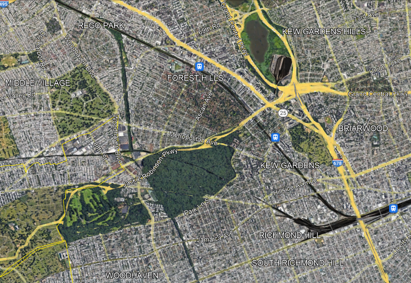
The Cutoff has two competing proposals for what to do with this disused LIRR branch: the Queenslink, aiming to convert it to a rapid transit branch (connecting to the subway, not the LIRR), and the Queensway, aiming to convert it to a linear park. The Queenslink proposal is somewhat awkward (which doesn’t mean it’s bad), but the Queensway one is completely drunk. Look at the satellite photo above and compare to that of the High Line:
- The area is full of greenery and recreation already, easily accessible from adjoining areas. Moreover, many residents live in houses with backyards.
- The density is moderate at the ends (Forest Hills and Woodhaven) and fairly low in between, with all these parks, cemeteries, and neighborhoods of single-family houses and missing middle density. Thus, local usage is unlikely to be high. Nor is this area anyone’s destination – there are some jobs at the northern margin of the area along Queens Boulevard (the wide road signed as Route 25 just north of the LIRR) but even then the main job concentrations in Queens are elsewhere.
- There is no real reason someone should use this as a hiking trail unless they want to hike it twice, one way and then back. The nearest viable parallel transit route, Woodhaven, is a bus rather than a subway.
The idea of a park is always enticing to local neighborhood NIMBYs. It’s land use that only they get to have, designed to be useless to outsiders; it is also at most marginally useful to neighborhood residents, but neighborhood politics is petty and centers exclusion of others rather than the actual benefits to residents, most of whom either don’t know their self-appointed neighborhood advocates or quietly loathe them and think of them as Karens and Beckies. Moreover, the neighborhood residents don’t pay for this – it’s a city project, a great opportunity to hog at the trough of other people’s money. Not for nothing, the Queensway website talks about how this is a community-supported solution, a good indication that it is a total waste of money.
But in reality, this is not going to be a useful park. The first park in a neighborhood is nice. The second can be, too. The fifth is just fallow land that should be used for something more productive, which can be housing, retail, or in this case a transportation artery for other people (since there aren’t enough people within walking distance of a trail to justify purely local use). The city should push back against neighborhood boosters who think that what worked in the Manhattan core will work in their explicitly anti-Manhattan areas, and preserve the right-of-way for future subway or commuter rail expansion.

What about freeway caps in dense urban areas? Do you think linear parks could be useful in this context, or should housing be built on top? I’m thinking of the Hollywood freeway cap proposal on the 101 in LA. I don’t know if it would be feasible to convert that freeway to a boulevard as has been done in other cities like the Rochester Inner Loop.
Freeway caps have a lot of problems of their own:
1. They’re freeway tunnels, so they’re expensive – the fact that they’re not literally dug in doesn’t change ventilation and escape requirements.
2. Linear parks on top of freeways are rarely nice to walk around, unless there’s soundproofing and a lot of cityscape around rather than freeway exits. The park on top of the Big Dig sort of qualifies; I can’t think of other American examples.
3. Overbuilding is difficult – it’s pretty much always better to build on firma.
Demolishing a freeway and having an at-grade road in its stead can work but that’s a reduction in car capacity, not some kind of magical solution that works for both cars and not-cars.
Another American, and somewhat nice, freeway cap park is in downtown Seattle: https://www.seattle.gov/parks/find/parks/freeway-park
Expensive and over promoted. Astori is divided by the Grand Central Triboro approach. In fact an entire commercial district was removed. Yet the neighborhood continued to thrive.
So much for the idea that freeways destroy neighborhoods
I think this is a good framework for judging whether a linear park makes sense. The same criteria can be used for boulevard medians, which often seem to go unused, even if there’s medium/high density, but plenty of other parks. The promenade plantée in Paris is a positive example, given the surrounding density, the lack of parks (at the Bastille end) and the good transit access (I used it when I had to catch a train at Gare de Lyon).
Those lesser used linear parks are still fine as bike paths, but that doesn’t really preclude building rail. Especially on a relatively wide alignment like the Queenslink. There are lots of examples of well used bike paths next to railways in urban/suburban settings the Netherlands.
It was originally a freight rail branch of the New York Central
It predates the New York Central and Grand Central. Commodore Vanderbilt didn’t get the urge to merge until after the trains were running, down the middle of the street, to St. John’s Terminal. Robert Moses had the grand idea to put the mess up on an el or under the park in the 1920s. That’s when they gave up running passenger trains on it. You can still see where the tracks went through the Bell Labs building on the Washington Street side, between Bank and Bethune Streets. Forever and ever because the buildings have been declared a Historic Landmark. The glittery condos along West Street, south of there, are there because nobody wanted to put the icky stuff between the elevated highway and the elevated freight tracks into the Greenwich Village Historic District. They could build glittery condos.
The newer overlapping historic districts were up in arms when Google wanted to convert former National Biscuit Company buildings to office space. They were aghast that people might be working in former factory buildings where people, worked, making Nabisco products.
a remnant of the West Side Highway that is not safe for pedestrians to cross, car traffic is so fast and heavy.
West Street predates the Commissioner’s Plan of 1811. People were escaping the crowded city to the bucolic suburbs up on what is now called Christopher Street. It’s why the street grid around there is so screwy. One farm got subdivided on one grid and the other one a different one. The city then carved Seventh Ave. South through for the IRT. Then built the West Side Highway and the High Line.
New Yorkers didn’t ask your opinion about West Street and use the park anyway.
https://en.wikipedia.org/wiki/2017_New_York_City_truck_attack
They like it so much they scared up a quarter of billion dollars to put more park in the river.
https://en.wikipedia.org/wiki/Little_Island_at_Pier_55
…..it does have something to do with city sending sewage to a treatment plant instead of dumping it, untreated, into the harbor in the 1980s.
The Queenslink proposal is somewhat awkward (which doesn’t mean it’s bad),
It’s bad. Compared to other things they could spend the money on. For the same reasons it won’t make a good park. There aren’t a lot of people out there and probably never will be, comparatively speaking. And it’s bad because people are already using the Queens Blvd. lines and people who can juggle two things at time would come up with things that discourage using the Queens Blvd. lines not encourage them. Remote from Woodhaven. That might even improve things for Woodhaven. That don’t involve having the LIRR stop every 20 blocks in Brooklyn and Queens.
Right on the mark.
Could someone explain to me why American elevated lines are so rickety/ugly/not-very good compared to Victorian British ones (let alone modern concrete ones)?
We probably spent more money on ours.
I think it’s pure steel construction versus either masonry or a combination of steel and masonry. The early-1900s els here and in Paris are pretty noisy by more modern standards but much less than their New York counterparts and emit less noise than the cars do at street level.
So its probably a function that in 1850 Steel isn’t the “cheap” option. Or maybe its that at the time UK economy had abundance of thermal energy and skilled artisanal labourers which meant masonry was cheap enough. Or maybe its just what was mandated.
New York built a ton of masonry at the same time it built steel els – just look at all the buildings. I don’t know why it didn’t use that for the els.
I’m less familiar with NYC and London, but comparing Chicago and Tokyo, I think the difference is in the routes elevated lines take.
Elevated lines from that era in the US were commonly built directly over streets as a second level along the same corridor. That is easier to do with steel than masonry, and probably set the standard for even when the viaduct doesn’t run over a street.
Masonry elevated rail viaducts in Tokyo generally run in their own corridor, elevated for grade separation at intersections, not for running along and over a street. The streets that run with the rail corridor don’t go under, but rather along side the rails. The space directly under the rail corridor is used for shops or storage.
I will say, in Berlin the separate ROW els (i.e. the Stadtbahn) are quieter than the street median els (i.e. U1, U2). But even the latter are quieter than New York els.
Looking at Google Street View a bit – Paris’s el has steel bridges and concrete (?) pillars, one el in Berlin is all steel, another has steel bridges and masonry pillars – it’s not clear why any of these should be much quieter than NYC’s els. I would guess that London differs from all these cities in that London’s els aren’t over streets, so they could be built on embankments supported by masonry, there was no need for continuous steel bridges in order to preserve street space for other vehicles.
What about imitating Catherijnesingel? https://www.theguardian.com/world/2020/sep/14/utrecht-restores-historic-canal-made-into-motorway-in-1970s
Utrecht may be relatively unique in turning a canal turned highway back into a canal, but there are advocates in other cities who point to Utrecht when they propose similar plans.
For example A73 in Germany sits to a relatively large extent on the bed of the former Ludwig Donau Main Kanal. Where the canal is still extant it is very popular with hikers, cyclists and the like – A73 and the area immediately around it very much isn’t.
The current proposal by the city of Nuremberg is to expand A73 get rid of the last few intersections not yet built to Autobahn standards and ultimately have the whole thing disappear underground. The city of Erlangen likewise would like to see A73 disappear in a tunnel – but this is only possible if it is expanded. “Just shut the thing down” is not currently something anyone of note in Erlangen city politics advocates.
https://nfsk.de/ here is the (German language) website of the group advocating for the canal…
How much of this is right-wing Bavarian politics? (But I guess the Erlangen mayor is SPD? So is it more like the petty localism of soi-disant left-wing American cities?)
What do you mean?
American central cities are pretty much all run by Democrats who use left-populist language; New York’s was endorsed by a member of Congress who claimed he was more left-wing than Alexandria Ocasio-Cortez and had read “both volumes of Capital” in college. Then they govern based on the preferences of local notables and don’t do anything that recalls any actual political agenda, like access to health care or raising teacher salaries or effecting a green transition.
One of the major policy actions of the early de Blasio was signing a new contract with the teachers union, after the teachers worked without a contract because they couldn’t come to terms with Bloomberg (primarily because right-of-NYC-center Bloomberg didn’t want to give the teachers as much money as de Blasio did, based upon the generic right-wing coverage). So no, pointing to not raising teacher salaries is not a valid criticism of de Blasio. Odd that was the example you went for, when “just pay teachers more” is very in vouge for Democrats.
https://www.nyc.gov/office-of-the-mayor/news/195-14/mayor-de-blasio-uft-reach-preliminary-agreement-9-year-contract-ushering-key-new-reforms-and#/0
https://nypost.com/2014/05/04/de-blasio-gives-away-the-store-in-teachers-contract/
Health care is a national issue that gets administered by the individual states, the school board is independent and cities don’t do things like regulate automobiles or utilities. So you want the mayor to do something !! !! !! the city doesn’t have any control over. Okay.
In New York the schools are run by the mayor. And in all US cities, the municipal government can do road diets but chooses not to.
Silly silly me, I thought the word “cities” was plural. And “Democrats”. There are other places in the U.S. outside of New York. Lots and lots and lots of them.
New York City is very very odd in that the mayor has some control over the school board. Even then they do what they do. You can’t change the sign from “No parking” to “No stopping or standing” without approval of the state DOT. It can take years to have a stop sign put in. Even in New York CIty ConEd and National Grid are regulated by the state. You are imagining that Superman will solve all your ills. ….your authoritarian streak is showing. Again.
The other place I was thinking of is San Francisco, which technically has a school board but really the municipal government runs nearly everything, to the point that the school board is just a feeder for Board of Supervisors candidates (and thus “this person would vote for the YIMBY/NIMBY agenda” is somehow an argument actual voters have for preferring one candidate to another for the school board).
That’s the way this pesky pesky democracy works most of the time. You run for a local office and win and then you run for a more important local office and win and perhaps run for a state office or even maybe a House seat. It’s a great pity they didn’t delegate it all to you.
Right, except you’re missing what I’m pointing out to you, which is that the city government in both cities controls the schools de facto and can raise funds for them, except that somehow nobody runs on raising teacher salaries. Then there’s the issue of streets and road diets, which the municipal government does do once in a blue moon when it suits it. The deeper issue is that the sort of people who run city government in the US (and often also the ones who get elected to Congress) think that the role of government is to provide makework jobs, and social change comes from NGOs and maybe unions, so it’s the job of the teachers’ union to agitate for better standards and the city government must always be adversarial to it.
and the populations of San Francisco and New York City combined are not quite ten million. There are more than 300 million other people and many many many places to live in the rest of the country. Including quite a lot of school districts that include many municipalities. Your authoritarian view across Ninth Ave is showing.
Yes, the part where the US system is “if you care about schools you should segregate and suburbanize” is part of the problem. Over here instead the election of a left-wing state government does lead to higher salaries for teachers serving working-class students (Grundschule and Haupt-/Real-/Gesamtschule, as opposed to Gymnasium); there are still racists who white-flee diverse cities, but it’s less prevalent than in the US and the people who replace them are just as middle-class.
Like they did in Minneapolis where there weren’t many non-white people to flee?
Surprisingly Federal government mortgage insurance is regulated by the Federal government, not cities or states. They bought houses in the suburbs because they could get one of those revolutionary 30 year self amortizing mortgages and get running hot water and central heat in the deal. Instead of killing off grandma so they could get her apartment.
Wow….
an honest perspective despite violating all the virtue signals of the NIMBYs and anti-automobile fanatics.
The best and cheapest option for this line with the anticipated opening of Grand Central Madison would be LIRR reactivation. The MTA’s price tag of $8 billion however is ridiculous. We’re talking about clearing trees, inspecting through spans with possible replacement of some, building a low elevated structure over the Crescent apartment building parking lot and Union Turnpike and building a handful of ADA accessible stations. The proposed stations would be at Fleet St./66Ave, Metropolitan Ave. (Parkside), Union Turnpike, Victory Field (Myrtle Ave), Park Lane South, Jamaica Ave (Brooklyn Manor), Atlantic Avenue (Woodhaven Jct), 101 Avenue (Ozone Park), Plattwood Avenue and an elevated station adjacent to the NYC Transit Aqueduct Racetrack Station. All stations would be outside platforms except Park Lane South (island platform) Plattwood Avenue, similar to Kings Highway on the NYC Transit Brighton Beach line with the subway berthing on the outside tracks and the LIRR on the center tracks for easy cross platform transfers and the Aqueduct Station which would be a terminal with 4 tracks and two island platforms. I grew up with this line as my playground in Woodhaven. It should either be reactivated for rail use or left in its natural state.
This piece illustrates how blind these activists really are to reality. So:
1. Well over 100k residents don’t need this space for walking AND biking because a few hundred people have private back yards in the vicinity? That’s NOT green space for the community.
2. Those same people with yards prefer a loud train burrowing through their back yards? LOL
3. The cost for a much lesser used piece of transport will cost many billions more than what would be a major bike transit throughway.
None of this resembles the High Line at all. And I’m just getting started. Typical misinformation propaganda by ‘social justice interest groups.
The Queensway would be a major win for residents, not just the handful at the far end of the railway.
Walk and bike on streets or in the existing park space in the neighborhood.
They had it until 1962. They didn’t use it.
The Shinkansen is only 70dB when it’s running at full tilt, so trains can be pretty quiet.
Most trains are quiet when they are cruising at full speed. They are louder when they are accelerating or braking, especially when entering or leaving a station.
Also the NYC subway leaves a loud impression because of those rickety steel girder els.
This thing in Jersey City seems to check the boxes? https://goo.gl/maps/utBzKE1w3LkFUnaDA
You are making a ridiculous comparison. I sted of comparing it to the High Line why not compare to city rail trails. Think Minuteman Trail. This piece is nearly devoid of truth.
I could talk about how the Somerville Community Path is dark and the buildings don’t face it and the women I know in the area tell me they’re sexually harassed there more than on the street.
So you found one trail in America that may have poor lighting (that NYC could easily avoid) and that is a valid argument? I am not familiar with the Somerville path, but the Yelp reviews are very positive and include several female reviewers. I could name numerous beloved city rail trails. Build it and they will come.
No, I found one trail that I used as a pedestrian shortcut, and it was desolate, as if its sole purpose is occasional recreation in an area that’s not dense enough to support it. Build it and it will be desolate.
Most paths in Westchester, NY are parks which close at dusk. Even in daylight, the stretches where you can’t get off can feel isolating and scary. The High Line and Manhattan Greenway work bc they are crowded. Less crowded ones in less dense areas not as much.
I also liked Cap’n Transit’s idea of using it to extend the subway.
Perhaps the introduction of the spotted lanternfly into the ecosystem of lower Manhattan is the greatest thing about the high line, not.
Your general point is good, but I will say the neighborhood doesn’t have as much parkland as it seems from the satelite view– of the 6 large green areas in the photo 3 are cemeteries (not a place people really want to hang out and relax) and 1 is a golf course. The one with the lake is technically a park but barely qualifies– it’s a swamp with one unpaved path across it. Only Forest Park is an actual park.