Edge Cities With and Without Historic Cores
An edge city is a dense, auto-oriented job center arising from nearby suburban areas, usually without top-down planning. The office parks of Silicon Valley are one such example: the area had a surplus of land and gradually became the core of the American tech industry. In American urbanism, Tysons in Virginia is a common archetype: the area was a minor crossroads until the Capital Beltway made it unusually accessible by car, providing extensive auto-oriented density with little historic core.
But there’s a peculiarity, I think mainly in the suburbs of New York. Unlike archetypal edge cities like Silicon Valley, Tysons, Century City in Los Angeles, or Route 128 north of Boston, some of the edge cities of New York are based on historic cores. Those include White Plains and Stamford, which have had booms in high-end jobs in the last 50 years due to job sprawl, but also Mineola, Tarrytown, and even New Brunswick and Morristown.
The upshot is that it’s much easier to connect these edge cities to public transportation than is typical. In Boston, I’ve spent a lot of time trying to figure out good last mile connections from commuter rail stations. Getting buses to connect outlying residential areas and shopping centers to town center stations is not too hard, but then Route 128 is completely unviable without some major redesign of its road network: the office parks front the freeway in a way that makes it impossible to run buses except dedicated shuttles from one office park to the station, which could never be frequent enough for all-day service. Tysons is investing enormous effort in sprawl repair, which only works because the Washington Metro could be extended there with multiple stations. Far and away, these edge cities are the most difficult case for transit revival for major employment centers.
And in New York, because so much edge city activity is close to historic cores, this is far easier. Stamford and White Plains already have nontrivial if very small transit usage among their workers, usually reverse-commuters who live in New York and take Metro-North. Mineola could too if the LIRR ran reverse-peak service, but it’s about to start doing so. Tarrytown and Sleepy Hollow could be transit-accessible. The New Jersey edge cities are harder – Edison and Woodbridge have lower job density than Downtown Stamford and Downtown White Plains – but there are some office parks that could be made walkable from the train stations.
I don’t know what the history of this peculiar feature is. White Plains and Mineola are both county seats and accreted jobs based on their status as early urban centers in regions that boomed with suburban sprawl in the middle of the 20th century. Tarrytown happened to be the landfall of the Tappan Zee Bridge. Perhaps this is what let them develop into edge cities even while having a much older urban history than Tysons (a decidedly non-urban crossroads until the Beltway was built), Route 128, or Silicon Valley (where San Jose was a latecomer to the tech industry).
What’s true is that all of these edge cities, while fairly close to train stations, are auto-oriented. They’re transit-adjacent but not transit-oriented, in the following ways:
- The high-rise office buildings are within walking distance to the train station, but not with a neat density gradient in which the highest development intensity is nearest the station.
- The land use at the stations is parking garages for the use of commuters who drive to the station and use the train as a shuttle from a parking lot to Manhattan, rather than as public transportation the way subway riders do.
- The streets are fairly hostile to pedestrians, featuring fast car traffic and difficult crossing, without any of the walkability features that city centers have developed in the last 50 years.
The street changes required are fairly subtle. Let us compare White Plains with Metrotown, both image grabs taken from the same altitude:
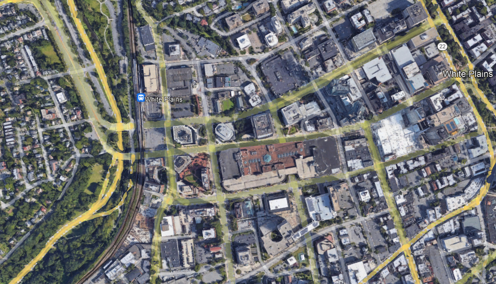

These are both edge cities featuring a train station, big buildings, and wide roads. But in Metrotown, the big buildings are next to the train station, and the flat-looking building to its north is the third-largest shopping mall in Canada. The parking goes behind the buildings, with some lots adjoining Kingsway, which has a frequent trolleybus (line 19) but is secondary as a transportation artery to SkyTrain. Farther away, the residential density remains high, with many high-rises in the typical thin-and-tall style of Vancouver. In contrast, in White Plains, one side of the station is a freeway with low-density residential development behind it, and the other is parking garages with office buildings behind them instead of the reverse.
The work required to fix this situation is not extensive. Parking must be removed and replaced with tall buildings, which can be commercial or residential depending on demand. This can be done as part of a transit-first strategy at the municipal level, but can also be compelled top-down if the city objects, since the MTA (and other Northeastern state agencies) has preemption power over local zoning on land it owns, including parking lots and garages.
On the transit side, the usual reforms for improvements in suburban trains and buses would automatically make this viable: high local frequency, integrated bus-rail timetables (to replace the lost parking), integrated fares, etc. The primary target for such reforms is completely different – it’s urban and inner-suburban rail riders – but the beauty of the S-Bahn or RER concept is that it scales well for extending the same high quality of service to the suburbs.

Very interesting post 🙂
Considering the scale such a would have it’s completely hypothetical project, what about the possibility of simply deconstructing and downgrading 128 from a fully grade-separated highway to a boulevard integrated with the local street networks? I’m not sure how the FHWA would feel about that sort of project, considering that 128 is also I95, but if the MBTA would get their act together with commuter rail modernization, it seems like infill and densification could happen around the currently-existent auto-oriented sprawl that’s grown around commuter stations, until enough demand existed to redevelop the sprawl itself into something more transit-oriented.
After all, I could be way off, but wouldn’t that also tend to deflect some development pressure back to follow the commuter rail lines? If businesses are disincentivized to build offices around Boston and so instead build either closer in to it or around and oriented to the local stations, themselves? Additionally, most of the suburbs around those stations are old enough that they wouldn’t need to be completely car-dependent. For the most part, these aren’t the ridiculous 1/2-acre lot size McMansions around culs-de-sac; a lot of last-mile travel is conceivable on a bike in these areas, even if people would initially complain about winter cold and summer humidity.
It seems like if the enormous interchanges were gotten rid of, a lot of space could be redesigned so as to abet non-car travel on a local level. Inter-suburban travel could still be difficult to serve with transit until these towns densified some more, but it doesn’t seem like it’d be completely infeasible. Especially as a lot of the Sun Belt cities that have been absorbing U.S. population growth become more or less uninhabitable with climate change, it’ll be important to have the more climate-resilient parts of the country, like the northeast and the midwest, reworked so as to accomodate more people efficiently.
The main question for this is, why? The scale of development near Route 128 isn’t anything like that near an arterial road, even an auto-oriented one; the office parks don’t front the road and are often well behind it, because when the main transportation artery is a motorway, you want to be five minutes from it and not on it.
Redevelopment is also less viable than you portray it. The biggest demand for office space is in Downtown Boston and Kendall Square. Moderna is headquartered in Cambridge and has lab space in Norwood. In the four quadrant typology, Boston writ large is an old city with a strong core and also strong demand, but Route 128 is the opposite, with neither a core nor exceptionally strong demand. Nor is it that great of an idea to induce such demand: a boulevardized Route 128 will still have a much weaker transit modal split than Kendall, let alone Downtown Boston, so if the state has money for redevelopment, it should build more office towers in the core and do sprawl repair at the Seaport.
The why is primarily Greater Boston’s own self-interest. Institutions like Harvard, MIT, Mass General, etc., have chronic gravity, but nothing lasts forever. It’s entirely foreseeable that institutions in areas more willing and able to allow more population growth (either via redevelopment or sprawl) will come to prominence, and the region as a whole could face stagnation or decline. Knowing how NIMBY most of New England is, I phrased such a massive redevelopment as a hypothetical specifically because it would require a sea-change in how the region views itself, and is certainly not going to be seen in my lifetime.
Ecologically speaking, the northeast can sustain a lot more people than e.g., Phoenix or the Central Valley, yet a lot of people leave because housing is so expensive (among other reasons, of course). In my view, climate-resilient areas have a responsibility to house proportionately more people, and of course, it seems redundant to say that it’s in the self-interest of those regions to grow, in any case. A lot of the towns on 128 were bedroom communities for downtown before the ubiquity of cars brought office buildings out into suburban office parks.
Assuming that Boston did see a “reshoring” of jobs into its core, it’s still a better use of space to have denser residential developments in those bedroom communities than in downtown, if development pressure in the downtown were to necessitate choosing either-or. I’d argue that housing costs in the areas around 128 suggests there is, in fact, plenty of demand for redevelopment, and according to that four quadrant typology, that means that the right thing to do is make sure it’s TOD. I suppose you wouldn’t need to demote 128, but having grade-separated highway infrastructure is a great way to make TOD seem less important than it should be.
I think upzoning Cambridge is more productive than upzoning Route 128.
Oh, I agree. Likewise Somerville, Rivere, Brookline, Newton….There are tons of towns closer in that should be first, but part of making the entire metro areas more functional and less car-dependent is attending to their further-flung suburbs. Once the “lower” hanging fruit of densifying the core is down, the job should be to move outward and do the same, at least in proportion to demand for it. Again, I think housing prices and the current stature of Boston’s economy justifies at least preparing for that.
Is it clear that the Northeast is more ecologically sustainable than Phoenix or the Central Valley? The Northeast has better water resources for sure. But in terms of energy use for climate control, I think Phoenix and the Central Valley have a greater number of days a year when you can just open the windows for climate control, and the days when people want to use their heat pumps are usually days when they’ll be pumping a 20 degree F gradient from the outdoors, or at most 40 degrees at the peak of summer or winter, while in the Northeast you trade those 40 degree gradient summer days for 60 degree gradient winter days. My understanding is that energy use is a bigger concern for ecological sustainability than water use, though it’s possible that’s wrong.
Making water, if you need to, which seems increasingly likely for most of the American west, is incredibly energy intensive.
Wait, how much water is needed for personal consumption, as opposed to ornamental lawns?
Shipping water they do have, isn’t cheap either.
Energy use includes things like driving. And a lot depends on where your electricity comes from and how much driving you do.
https://en.wikipedia.org/wiki/List_of_U.S._states_and_territories_by_carbon_dioxide_emissions
New York’s per capita emission are lower than California’s. Washington D.C.’s are very low. But that is partly because they import electricity from other places. Like coal burning plants in West Virginia. New York’s are lower because there are less vehicles, per capita.
https://en.wikipedia.org/wiki/List_of_U.S._states_by_vehicles_per_capita
@alon the actual water issues in the American west are driven by agricultural and ranching consumption not by either lawns or industry. Currently the legal system privileges these claims and often allows them to draw water at insanely low costs, but eventually if the option is cut them or cut people’s personal consumption democracy will side with personal consumption not alfalfa and cotton farmers.
@Nilo and Alon Hence why it’s so important to get as many people as possible to let go of suburban delusions such as the importance of ornamental lawns, even those who live in places more distant from metropolitan cores. It’s been gross enough to have feedstock converted into ethanol for cars for all these years; let’s not perpetuate that propensity for misuse by letting people think grass is also more important than food.
If it is for personal consumption, then the output of a modern sewage treatment plant is drinkable water, they can feed it right back to the water system. It doesn’t cover water needs for lawns or evaporative cooling systems, but it is plenty for drinking water. The idea grosses people out so instead they send the water elsewhere (generally to a river), but it need not be that way.
Metrotown is an interesting choice for an edge city – it’s a third as far from the central business district as White Plains
Yeah, it’s not really an edge city at all. It’s an infill development between the historic centres of Vancouver & New Westminster. For an example of an edge city in Vancouver, you’d need to go out to Surrey or Lougheed/Coquitlam.
New developments in Hong Kong increasingly sound like contents described in this post, is probably a reason behind exponential growth of private car usage in the city. Already exceeded 700k cars in the city for the roughly 2.5 million families living in it, compared to 300k at the turn of century.
How much of that is just people getting richer and buying a car for the occasional weekend vacation or whatnot, not the daily commute? If the road capacity hasn’t increased, the amount of actual driving probably hasn’t increased much either.
Road capacity is in fact increasing. The issue in both Singapore and Hong Kong is that their traffic suppression systems are entirely money-based. Singapore famously has congestion pricing and less famously and more importantly has very high taxes on car purchases, so the result is that if you’re rich enough to afford a car (roughly top 30% of the population), you will get one and drive it everywhere, and if you’re not, you will crave being able to afford a car rather than having better alternative transport.
This leads to a lot of middle-class populist pressure to make the city car-friendlier, for example by building new freeways, which both cities do. Hong Kong’s pre-2019 social contract heavily centered middle-class consumer convenience (as does Singapore’s but Singapore’s centers so much foreign vacationing that the government does what it wants on local transport). It’s so ingrained that Carrie Lam tried bribing the democracy protesters with more housing construction and didn’t get why the response was “five demands, not one less” (nor did the protesters get why the regime didn’t just collapse).
Roads are also becoming more congested. Most notably, ten years ago all three tunnels that connect Hong Kong Island with Kowloon only have one of them that are frequently congested, nowadays the second one is also congested almost throughout the whole day and the third one which charge like 10USD per crossing and thus see minimal traffic ten years ago is now also reaching capacity.
Also extensive motorway construction and total inattention to livability, right? Singapore has shades of the latter but has a way less politically empowered consumer middle class.
New motorways in Hong Kong in 21st century, aka Route 6, 8, new section of Route 4, are mainly designed for truck traffic to bypass urban area. They do have the effect of alleviating congestion of roads and also make driving to different destination easier, but due to congestion, travel time by road probably isn’t better now than before for most origin-destination pairs.
As for “livability” that depends on how you define it I guess. Some of the new development do feel like they’re simply American suburbs except packing 50 layers of them onto each others. And then the government is even trying to, in the name of increase housing supply, reduce the amount of available parks and public facilities by converting them into more housing in the middle of other housing on what’s planned to be public use land.
Wait, something is weird about this – Hong Kong’s housing production, 4 units/1,000 people per year, is not good by European standards (Berlin: 5), let alone rich Asian ones (23 Special Wards: 11).
4 units per 1000 people appears to be outdated number from 1990s. After the Asian financial crisis the number of units completed each year have dropped to below 10k/year, which mean ~1.5units/k-ppl with population of HK. It have been improved a bit in recent years due to improved markets and such but it still only arrive at about 15-20k units completed /year, which mean about 2 to 3 units per thousand people each years.
A factor behind this could be all new town development have been freezed since 1997 Asian financial crisis and new projects that are restarting is not expected to see result by 2030, and old buildings are difficult to take down and renew as new building because many of the old building in Hong Kong even if built half a century ago have already reached legal maximum FAR ratio thus limiting potential profitability of reconstruction action to provide new housing by taking down old ones, and in the rural area then there are also political problem against using rural lands that are controlled by aboriginal residents of Hong Kong which for historical reason have been keep at density of detached housing and open industrial land.
Where should new housing in HK should be built in the first place?
HK is already very dense place and there aren’t a lot of low hanging fruits left.
Current proposals by Hong Kong government and other stakeholders include:
– Abandoned farmland and fish ponds
– Brownfield industrial lands
– Villages that are inhabited by non-aboriginal residents
– Former forbiddened area next to Hong Kong’s border with Mainland China
– Land reclamation
– Green field land next to country parks that are currently barred from redevelopment due to various regulations
– Relocate infrastructure facilities into rock cavern to free up urban spaces for other developments
– The empty land next to Disneyland, the military airfield in Kam Tin, the golf course in Northern District
– Borrow land from Mainland China, for example Guishan Island of Zhuhai
– Relocating some of the Hong Kong population to settlements in Mainland China, for example to Nansha Guangzhou
So mostly new development in the New Territories, what about in Hong Kong Island and Kowloon?
In Hong Kong Island and Kowloon they are mostly redevelopment of old buildings, but the pace is slow, even government imitative to redevelop old buildings are still very slow because the urban renewal authority are tasked to sustain their own cash flow as well as have to earn profit for the government, while also having to compensate property owners at market average price of semi-new properties nearby, hence they are moving at the pace of a few street blocks each year.
Hong Kong government try to improve the condition by lowering the barrier for private property developers to redeveloping old properties to force a deal to go through with only ~60-70% property owners agreeing the deal, but this is controversial because many older mixed use building have the ground floor commercial unit count as larger share of the whole building, hence property developers only need agreement of a few residents to force the deal to go through.
Another problem is, even for old buildings, they are still in demand and are traded expensively. Like the properties in Mei Foo and Taikoo despite being properties developed from 1960s-1970s, they’re still trading at US$2,000+ per square feet and is virtually on par with new built then buildings that are even older like before and right after World War II are still in active use by subdividing into smaller units for lower income population which actually charge above market average price per area compared to regular properties due to lack of alternative supply, hence making it difficult for private developers to expect a notable profit after paying and acquire such buildings for redevelopment.
There are also some small old villages and disused facilities in the area pending redevelopment.
There are also programs to convert factory buildings into residential buildings but factory building units are in short supply either.
Stamford was one of the old “streetcar suburbs” although going back even further it was always a port city halfway between New York and New Haven.
It also is trying to develop the land around the train station (Stamford Transportation Center). https://www.stcmasterplan.com/
Doesn’t Silicon Valley have historic cores with TOD and/r TAD along the Caltrain alignment, due to some of cities being old railroad towns?
Yes, but the jobs aren’t anywhere near these cores. There’s some commercial redevelopment in San Jose near Diridon, but it’s recent.
OK. I thought a few of the stations like Palo Alto had a decent amount of activity around them, but they must be small relative to the big office parks and intergalactic headquarters for most of the tech companies?
Yeah, downtown Palo Alto is fine for a suburban main drag, but pales next to the local tech campuses. One side of the train station fronts onto a major arterial road (El Camino Real–not a highway, but three traffic lanes in each direction, long blocks, at 35 MPH). Without crossing the arterial you get restaurants and retail/low-density commercial. Cross the arterial and there’s Stanford Shopping Center, or about a mile to Stanford Hospital; that’s not nothing, but it’s nowhere near the jobs density of a real hub–certainly nothing like the major tech office parks (which are generally several miles, and across a major freeway, from the closest CalTrain stop).
Silicon Valley didn’t really stop being dominated by agriculture until well into the postwar tech boom–at which point auto-oriented development was king–so it never had a historic core comparable to the East Coast cities (or even San Francisco).
Reblogged this on Calculus of Decay .
Interesting post, Alon. The scale view of White Plains near the station led me to wonder: were the large blocks the result of urban renewal/negro removal? It turns out that checking a map from the 1930s shows that WP always had those big blocks, as opposed to the smaller housing plats in Metrotown.
https://collections.westchestergov.com/digital/collection/1930atlas/id/91/rec/4
There’s a large, dying mall about 5 minutes from the WP station. Jane Jacobs would cut a few more streets through the area, build some interesting buildings to end the blight of dullness, and try to restore street life to the area. Your suggestions would do a lot to add more people to downtown, where even the NIMBYs cannot object. It’s an eyesore, especially the Galleria mall (the white plains mall is even worse), and turning it into a mid rise district would help. Contrast the stretch from the WP train station with still-lively Mamaroneck Avenue for a sense of what could be.
Dead mall. They went and built a fancy mall a few blocks away and then a smaller mixed use-y New Urbanist chain store haven a block away. It’s closing in March for redevelopment. With solar panels!
Indeed, the Galleria is the biggest walkability inhibitor. It’s only half a mile, 10 mins by foot from the center to the train station. There are proper sidewalks. But the mall makes it drab along with the huge parking lots. Some street-facing shops would go a long way to make it more pleasant.