Category: Regional Rail
Don’t Run Bilevels
For years, the RER A’s pride was that it was running 30 trains per hour through its central segment in the peak direction (and 24 in the reverse-peak direction). With two branches to the east and three to the west, it would run westbound trains every 2 minutes between 8 and 9 in the morning on the seven-station shared trunk line. Moreover, those trains are massive, unlike the trains that run on the Metro: 224 meters long, and bilevel. To allow fast boarding and alighting at the central stations, those trains were uniquely made with three very wide doors per side, and two bilevel segments per car; usually there are two doors near the ends of the car and a long bilevel segment in between. But now the RER A can no longer run this schedule, and recently announced a cut to 24 peak trains per hour. The failure of the RER A’s bilevel rolling stock, called the MI 2N or MI 09, should make it clear to every transit agency mulling high-throughput urban rail, including RER A-style regional rail, that all trains should be single-level.
On most of the high-traffic regional rail lines of the world, the trains are single-level and not bilevel. The reasoning is that the most important thing is fast egress in the CBD at rush hour. For the same reason, the highest-traffic regional rail lines tend to have multiple CBD stops, to spread the load among several stations. The Chuo Rapid Line squeezes 14 trains in the peak half-hour into Tokyo Station, its only proper CBD station, discharging single-deck trains with four pairs of doors per 20-meter-long car onto a wide island platform with excellent vertical circulation. Bilevels are almost unheard of in Japan, except on Green Cars, first-class cars that are designed to give everyone a seat at a higher price point; on these cars, there aren’t so many passengers, so they can disembark onto the platform with just two doors, one per end of the car.
Outside Japan (and Korea, where the distinction between the subway and regional rail is even fuzzier), the busiest regional rail system is the RER. The RER A runs bilevels, but the most crowded line while the RER A was running 30 tph was the RER B, which runs 20 tph, through a tunnel shared with the RER D, which runs 12 bilevel tph. Outside Paris, the busiest European regional rail systems are in London (where bilevels are impossible because of restricted clearances), and in Berlin, Madrid, and Munich, all of which run single-level trains. Berlin and Munich moreover have three door pairs per 17-to-18-meter car. Munich squeezes 30 tph through its central tunnel, with seven distinct branches. Other than the RER A, it’s the less busy regional services that use bilevels: the RER C, D, and E; the commuter trains in Stockholm; the Zurich S-Bahn and other Swiss trains; Dutch regional trains; and many low-performance French provincial TERs, such as the quarter-hourly trains in the Riviera.
Uniquely among bilevels, the RER A’s MI 2N (and later MI 09) was designed as a compromise between in-vehicle capacity and fast egress. There are three triple-width door pairs per car, allowing three people to enter or exit at once: one to the lower level, one to the upper level, one to the intermediate vestibule. The total number of door pairs per unit of train length is almost as high as on the RER B (30 in 224 meters vs. 32 in 208), and the total width of these doors is much more than on the RER B, whose doors are only double-wide.
Unfortunately, even with the extra doors, the MI 09 has ultimately not offered comparable egress times to single-level trains. Present-day peak dwell times on both the RER A and B are about 50-60 seconds at Les Halles; here, the RER B, with its prominent Gare du Nord-to-Les Halles peak in the morning, is in a more difficult urban geography than the RER A, with four stations that could plausibly lay claim to the CBD (Les Halles, Auber, Etoile, La Defense). The RER B has long had problems with maintaining the schedules, due to the 32 tph segment shared with the RER D, using traditional fixed-block signaling; the RER A in contrast has a moving-block system called SACEM. But now the RER A has problems with schedule reliability too, hence the cut in peak frequency.
The problem is that it’s not just the number of doors that determines how fast people can get in and out. It’s also how quickly passengers can get from the rest of the train’s interior to the doors. Metro systems optimize for this by having longitudinal seats, with their backs to the sides of the train, creating a large, relatively unobstructed interior compartment for people to move in; Japanese regional trains do the same. European regional trains still have transverse seating, facing forward and backward, and sometimes the corridors are so narrow that queues form on the way to the vestibules, where the doors are. The RER A actually has less obstructed corridors than the RER B. The problem is that it’s still a bilevel.
Bilevel design inherently constrains capacity on the way to the door, because the stairs from the two decks to the intermediate level, where the door is, are choke points. They are by definition only half a train wide. They are also slow, especially on the way down, for safety reasons. When the train is very crowded, people can’t just push on the way up or down the way they can on a flat train floor. If passengers get off their seats in the upper and lower levels well in advance and make their way to the intermediate-level vestibules then they can alight more quickly, but on a train as crowded as the RER A, the vestibule is already full, and people resort to sitting on the stairs at rush hour, obstructing passageways even further.
As a result, RATP is now talking about extending peak dwells at the central stations to 105 seconds, to stabilize the schedules. Relative to 60-second dwells, this is 45 seconds of padding per station; with about 3 minutes between successive stations in the central segment, this is around 25% pad (on top of the already-existing pad!), a level worthy of American commuter trains rather than of Europe’s busiest commuter rail line.
What’s more, this unique design cost the region a lot of money: Wikipedia says the MI 09’s base order was €3.06 million per 22.5-meter car, and the option went up to €4.81 million per car. In contrast, German operators have purchased the high-performance single-level Coradia Continental and Talent 2 for €1.25-1.5 million euros per 18-meter car (see orders in 2014, 2016, and 2017); these trains have a top speed of 160 km/h and the power-to-weight ratio of a high-speed train, necessary for fast acceleration on regional lines with many stops. Even vanilla bilevel trains, with two end-car door pairs, are often more expensive: at the low end the Regio 2N is €7.06 million per 94-meter trainset, at the higher end the high-performance KISS is around €3 million per 25-meter car (about 2.7 in Sweden, 3-3.5 in Azerbaijan), and the Siemens Desiro Double Deck produced for the Zurich S-Bahn in 2003 was around €3 million per 25-meter car as well.
High-traffic regional railroads that wish to improve capacity can buy bilevel trains if they’d like, but need to understand the real tradeoffs. Average bilevel trains, with a serious decrease in capacity coming from having long upper- and lower-level corridors far from the doors, can cost 50-100% more than single-level trains. They offer much more capacity within each train (the KISS offers about 30% more seats per meter of train length, with a small first-class section, than the FLIRT), but the reduction in capacity measured in trains per hour cancels most of the benefits, except in cases where peak dwells don’t matter as much, as in Zurich with its two platform tracks per approach track. In terms of capacity per unit cost, they remain deficient.
The MI 09 was supposed to offer slightly less seated capacity per unit of train length and equivalent egress capacity to single-level trains, but in practice it offers much less egress capacity, at much higher cost, around 2.5-3 times as high as single-level trains. If RATP had bought single-level trains instead of the MI 09, optimized for fast egress via less obstructed passageways, it would have had about €2.5 billion more. Since the cost of extending the RER E from Saint-Lazare to La Defense and beyond is about that high, the region would have had money to obtain far more capacity for east-west regional travel already.
The American or Canadian reader may think that this analysis is less relevant to the United States and Canada, where the entire commuter rail ridership in all cities combined is about the same as that of just the RER A and B. Moreover, with higher US construction costs, the idea of saving money on trains and then diverting it to tunnels is less applicable than in Paris. However, two important American factors make the need to stop running bilevels even more pertinent than in Europe: CBD layout, and station construction costs.
North American CBDs are higher-rise than European ones – even monocentric cities like Stockholm have few city center skyscrapers. The job density in Paris’s job-densest arrondissement (the 2nd) is about 50,000/km^2, and it’s higher in its western end but still only about comparable to Philadelphia’s job density around Suburban Station. Philadelphia has three central stations in the SEPTA commuter rail tunnel, but only Suburban is really in the middle of peak job density; Market East is just outside the highest-intensity zone, and 30th Street Station is well outside it. In Boston, only two proper CBD stations are feasible in the North-South Rail Link, South Station and Aquarium. In New York, Penn Station isn’t even in the CBD (forcing everyone to get off and connect to the subway), and only 1-2 Midtown stations are feasible in regional rail proposals, Penn and Grand Central. Some of these stations, especially Penn and Grand Central, benefit from multiple platform tracks per approach track in any plan, but in Boston this is not feasible.
The other issue is station construction costs. High construction costs in the US mean that spending more money on trains to avoid spending money on infrastructure is more economic, but conversely they also make it harder to build anything as station-rich as the RER A, the Munich S-Bahn tunnel, or Crossrail. They also make stations with multiple platform tracks harder to excavate; this is impossible to do in a large-diameter TBM. This makes getting egress capacity right even more important than in Europe.
New York and Philadelphia meandered into the correct rolling stock, because of clearance restrictions in New York and the lack of a domestic manufacturing base for bilevel EMUs. Unfortunately, they still try to get it wrong: New Jersey Transit is buying bilevel EMUs (the first FRA-compliant ones). Railroads that aren’t electrified instead got used to bilevel unpowered coaches, and get bilevel EMUs: Caltrain is getting premium-price KISSes (about the only place where this is justifiable, since there are sharp capacity limits on the line, coming from mixing local and express trains on two tracks), and the Toronto RER (with only one CBD station at Union Station) is also planning to buy bilevel EMUs once electrification is complete.
Paris’s MI 09 mistake is not deadly. The RER E extension to the west will open in a few years and relieve the RER A either way. Being large and rich can paper over a lot of problems. North American cities are much poorer than Paris when wages are deflated to tunnel construction costs, and this means that one mistake in choice of alignment or rolling stock can have long-lasting consequences for service quality. Learning from the most forward-thinking and successful public transit operators means not just imitating their successes but identifying and avoiding their failures.
RPA Fourth Regional Plan: the Third Avenue Trunk Line
Based on a Patreon poll, the top two priorities for this blog for critiquing the RPA Fourth Regional Plan are its mess of the LGA connection and the Astoria Line, and the proposed commuter rail trunk line on Third Avenue. The third priority is multi-tracking existing lines and timetable-infrastructure integration.
New York’s existing regional rail network suggests a north-south trunk line, starting from the Harlem Line in the north and continuing south to Lower Manhattan and beyond. Such a line would run parallel to the Lexington Avenue Line, providing additional express service, running fast not just between 125th Street and City Hall but also farther north and south. Going back to 2009, I have proposed such a line, controversially continuing on to Staten Island:
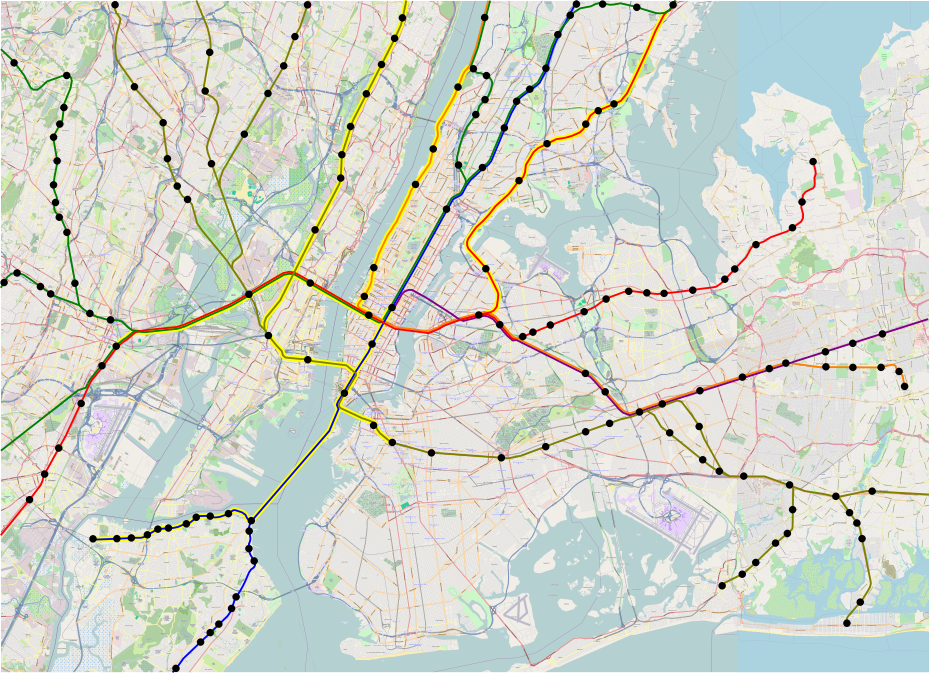
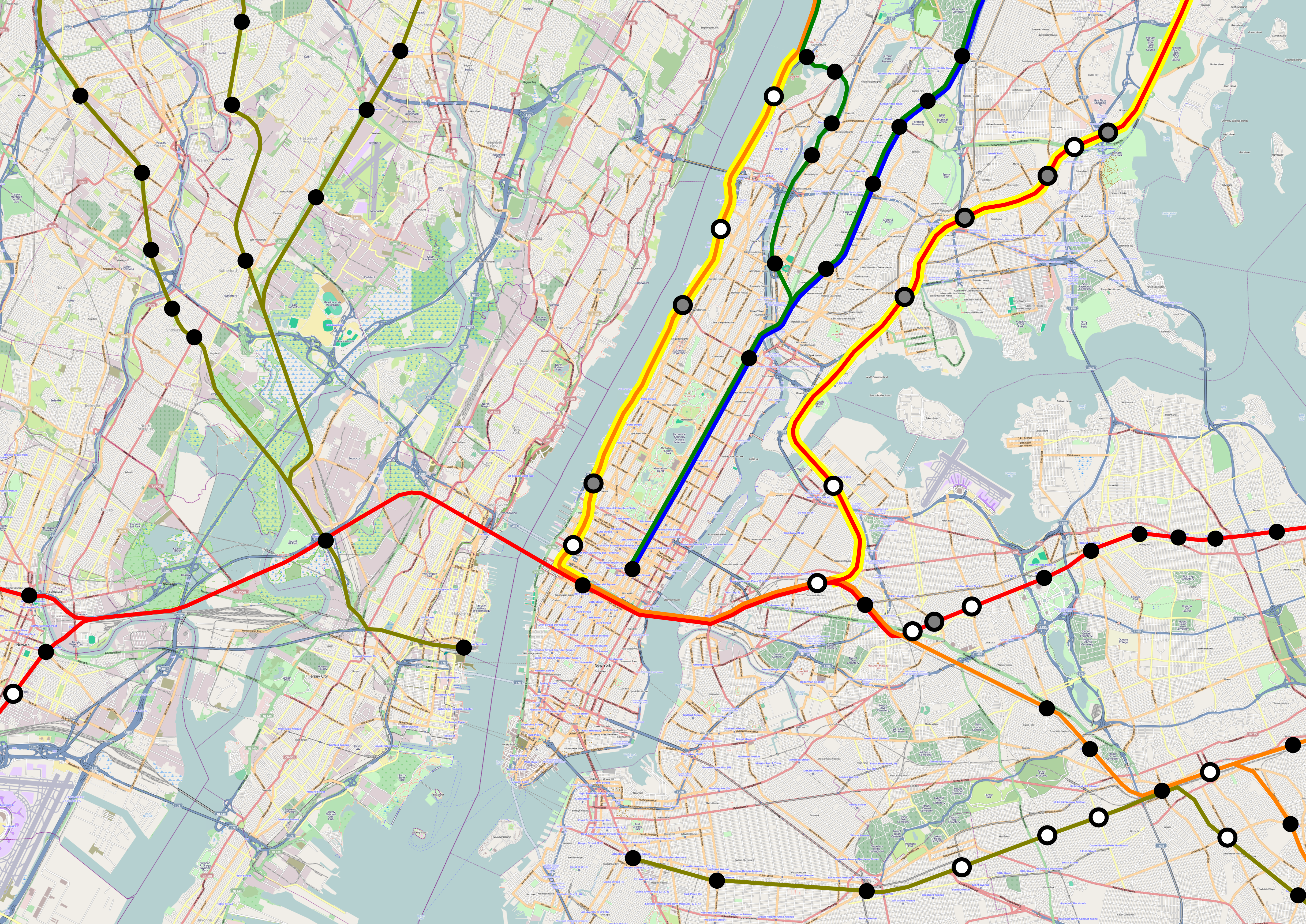
Of note, the depicted regional rail network makes use of the entirety of Grand Central’s approach tracks. There are four tracks, two used by Line 2 to Penn Station (the green line) and two by Line 4 (the blue line), the north-south trunk under discussion. In contrast, here is the RPA version:
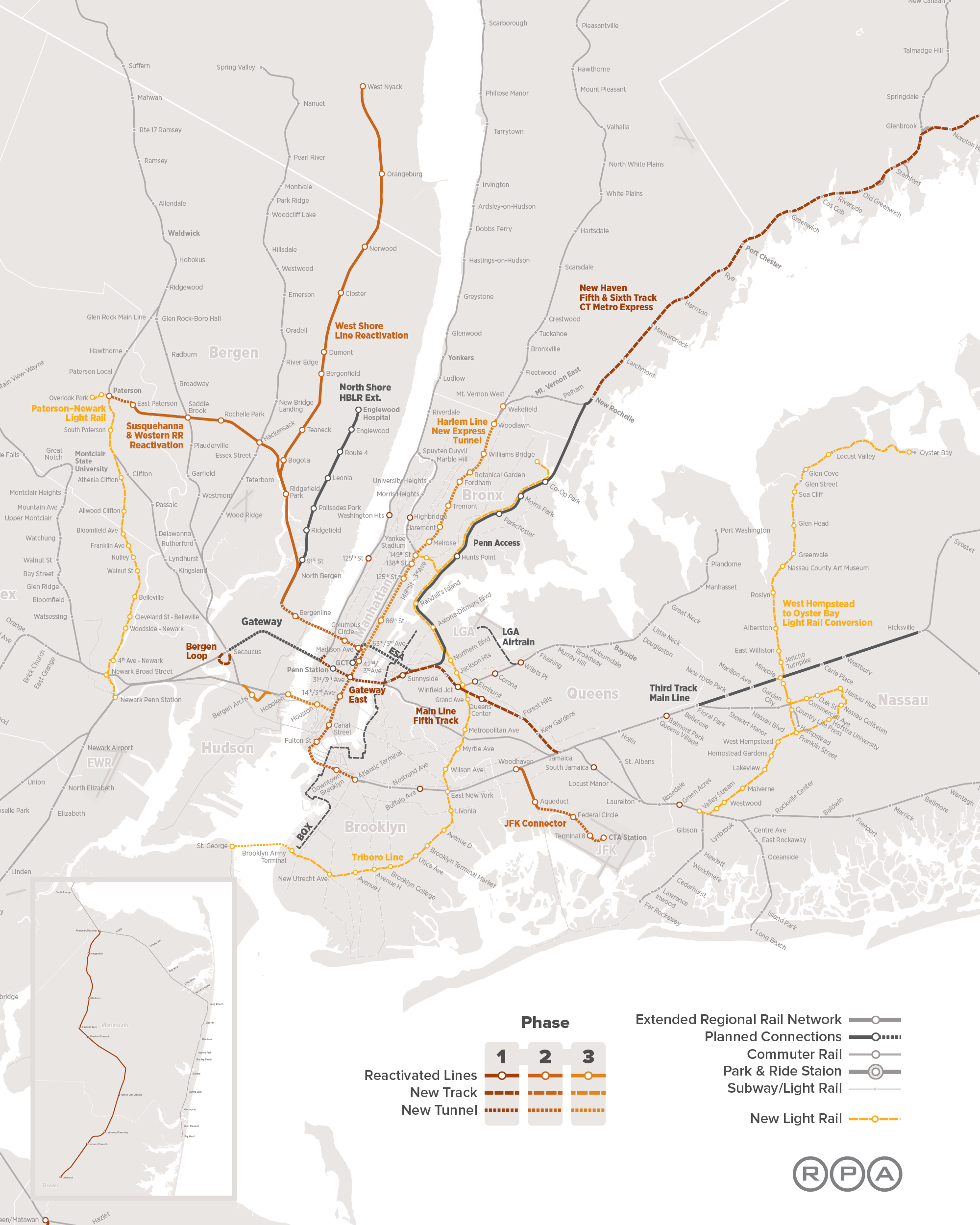
There is a lot more going on in the RPA version – more tunnels, some light rail lines – but the important thing to focus on in this post is the north-south trunk. The RPA is proposing the following items:
- A north-south trunk line under Third Avenue, with an onward connection to Brooklyn.
- Stops at 125th, 86th, 42nd, 31st, 14th, Canal, and Fulton Street.
- Two tunnels to New Jersey (in addition to Gateway), at 57th and Houston Streets, using Third Avenue to connect between them.
- A tunnel directly under the Harlem Line in the Bronx, called an express tunnel but making more stops, with infill at 138th and 149th Street, to intersect the 6 and 2/5 trains respectively.
I contend that all three elements are problematic, and should not be built without major changes.
1. Third Avenue
The RPA plan bypasses the existing tracks to Grand Central entirely. This simplifies scheduling, in the sense that all trains using Third Avenue are captive to the reorganized system from the start. It also serves the Upper East Side and East Harlem slightly better: there is more population density east of Third Avenue than west of it, so it materially benefits riders to have a commuter rail station on Third rather than on Park, where the current line goes.
Unfortunately, these advantages are swamped by the fact that this means the Fourth Regional Plan is proposing about 8 kilometers of tunnel, from 138th Street to 42nd, redundant with the existing Grand Central approach. At the cost I think is appropriate for urban tunnels, this is around $2 billion. At what New York seems to actually spend, start from $13 billion and go up.
Because this trunk line would have to be built from scratch, it also has necessarily limited capacity. The Grand Central approach has four tracks; Third Avenue is as far as I can tell based on the plan just two. Many trains on the Hudson and New Haven Lines would need to keep terminating at the existing Grand Central station, with no through-service; any transfer to the Third Avenue trunk would involve walking a long block between Park and Third Avenues, 310 meters apart.
The capacity limitation, in turn, forces some reverse-branching onto Metro-North, on top of that coming from future Penn Station Access lines (the connections from the New Haven and Hudson Lines to Penn Station, depicted on both the RPA map and my map). It is possible to avoid this by connecting just one of Metro-North’s line to the new trunk, probably the Harlem Line, and then make passengers from the other two lines go to the existing Grand Central. But at least as depicted in the map, this service pattern seems unlikely: the High Bridge infill stop suggests some Hudson Line trains would go to the trunk, too. Unfortunately, even without reverse-branching, service would not be great, since connections between the old and new system (especially with the Hudson Line) would require a long walk at 125th Street or Grand Central.
The long walk is also a problem for the trunk line from Grand Central south. According to OnTheMap, the center of gravity of Midtown jobs seems to be between Fifth and Sixth Avenues, with few jobs east of Third. While this trunk line is good for scooping Upper East Side passengers, it isn’t good for delivering them to their exact destination.
2. Stop Spacing
The RPA stop spacing is too local. The 4 and 5 trains stop at 125th, 86th, 59th, Grand Central, Union Square, City Hall, and Fulton Street. It’s for this reason that my map’s Line 4 is so express, stopping only at 125th Street, Grand Central, Union Square, and Fulton Street: the line parallels the Lexington Avenue Line so closely that it should offer a different stopping pattern. For the same reason, observe that I do not include any infill on the LIRR Main Line west of Jamaica, where is it closely parallel to the Queens Boulevard Line with its E and F express trains; on lines not so close to express subways, I have extensive infill instead.
In contrast, the RPA wants trains to make the same number of stops between Harlem and Lower Manhattan as the 4 and 5 subway lines, just at slightly different locations: 31st instead of 59th, Canal instead of City Hall.
The Canal Street location is understandable. Chinatown is a major destination, overshadowed by Midtown and Lower Manhattan but important in its own right; the Canal Street complex on the 6, N/Q/R/W, and J/Z is the 18th busiest subway station in New York on weekdays and the 11th busiest on weekends. It’s also an intersection point between the north-south trunk line and the N/Q trains (in addition to Union Square) and the J/Z trains (in addition to Fulton Street). I think it’s overall not a good idea to include this location, because the 4/5/6 exist, and the connections to the N/Q and J/Z also exist elsewhere, but I think the alternatives analysis for this project should include this station as an option.
In contrast, 31st Street is inexcusable. On the surface, the rationale for it is clear: provide a transfer point with the east-west tunnels feeding Penn Station. In practice, it is weak. The area is just frustratingly out of walking range from Midtown jobs for train riders. The transfer is good in theory, but in practice requires a new tunnel from Penn Station to Long Island, one that the RPA included because Long Island’s turf warriors wanted it despite complete lack of technical merit; the cost of this tunnel, according to RPA head Tom Wright, would be $7 billion. The only reason to include this connection in the first place is that RPA decided against a connection between Grand Central and Penn Station.
3. The New Jersey Tunnels
In New Jersey, the RPA believes in making no little plans, proposing three two-track Hudson crossings: Gateway, and two new tunnels, one connecting Bergen and Passaic Counties with 57th Street, and one from Hoboken to Houston Street. Tunnels in the general vicinity of these are good ideas. But in this plan, there’s one especially bad element: those tunnels link into the same Third Avenue trunk line.
The RPA has a tendency, going back to at least the Third Regional Plan, to hang many elements on one central piece of infrastructure. The Third Plan proposed Second Avenue Subway as a four-track line, with many branches hitting all the other priorities: regional rail, an express rail connection to JFK, more lines in Brooklyn and the Bronx – see schematic on PDF-p. 13 of the executive summary and more detail on PDF-pp. 204-207 of the full plan. Most of these elements were good on their own, but the connection to Second Avenue Subway made them more awkward, with extensive conventional- and reverse-branching, and a JFK connection that would miss all Midtown hotels.
On this plan, the need to link the new elements to the Third Avenue trunk leads to incoherent lines. High-frequency east-west trunks would make a lot of sense, complementing the north-south trunk, but instead of connecting Hoboken with Brooklyn and 57th Street with Long Island, both end up hooking to the north-south trunk and loop back to connect to each other. The proposed tunnels are already there, in the form of Gateway East and the trunk connection to Brooklyn, they just don’t align. Instead, the only east-west alignment that fully goes through is Gateway, with just one stop in Manhattan at Penn Station, except in the tunnel that also has an additional stop at off-Midtown 31st and 3rd.
4. Harlem Line Tunnel
Between Grand Central and Wakefield, the Harlem Line has four tracks. In the South Bronx, the Hudson Line splits off, but the rest of the Harlem Line still has four tracks. Thus, the Bronx effectively has six tracks feeding four in Manhattan. It is this configuration that probably led the RPA to believe, in error, that two additional regional rail tracks in Manhattan were required. In this situation, it is unlikely there will ever be capacity problems on the Harlem Line in the Bronx – the bottleneck is further south. So why is the RPA proposing to add two more tracks to the Harlem Line, in a tunnel?
In section 1 of this post, I defined the Third Avenue trunk’s unnecessary part as running from Grand Central to 138th Street, a total of 8 km. This tunnel, from 138th to the depicted northern end at Woodlawn, where the Harlem and New Haven Lines split, is 11 km. In a city with reasonable cost control, this should be around $2.5 billion. In New York, it would be much more – I can’t tell how much, since it is likely to be cheaper than the recent subway projects (Second Avenue Subway Phase 1, and the 7 extension), both of which were in Manhattan, but I would guess about $10 billion is in line with existing New York costs. Is there any valid reason to spend so much money on this tunnel?
When I interviewed Tom Wright and Foster Nichols for my above-linked Streetsblog piece, I only saw the plans around Gateway, and was aware of the Third Avenue trunk idea but not of any of the details, so I never got a chance to ask about the Harlem Line express tunnel. So I can only guess at why the RPA would propose such a line: it got some pushback from the suburbs about wanting more express trains. The RPA could try to explain to suburbanites that the new system would not be so slow in the Grand Central throat: Metro-North does the 6.6 km from 125th to Grand Central in 10 minutes; the trains are capable of doing it in 5-6 minutes, but the last 15 blocks are excruciatingly slow, which slowness would be eliminated with any through-running, via the existing tunnels or via Third Avenue. Instead, for the same reason the organization caved to Long Island pressure to include Gateway East, it caved to Westchester pressure to include more express tracks.
In reality, this tunnel has no merit at all. The way the existing suburban lines are laid out points to a clear service pattern: the Harlem Line on the local tracks, the New Haven Line on the express tracks (regardless if those trains run local or express on the New Haven Line farther out). Wakefield has four tracks and two platforms, but the Harlem and New Haven Lines split just short of it; perhaps new local platforms on the New Haven Line could connect to it, or perhaps the junction could be rebuild north of Wakefield, to enable transfers. With much of the New Haven Line capacity occupied by the reverse-branch to Penn Station Access, there wouldn’t be much of a capacity crunch on the express tracks; in a counterfactual in which reverse-branching is not a problem, some Harlem Line trains could even be routed onto the spare capacity on the express tracks.
Build a Network, Not One Line With Branches
In the short run, the biggest thing the RPA is proposing for regional rail in New York is Gateway plus tie-ins. But this doesn’t really distinguish it from what the politicians want. The real centerpiece of the Fourth Plan, as far as regional rail goes, is the Third Avenue trunk line – even taking over some functionality of Second Avenue Subway, which the RPA proposes to not build south of 63rd Street.
Unfortunately, this trunk line, while almost good, doesn’t quite work. It has 19 km of superfluous tunneling, from Grand Central to Woodlawn, adding no new service to the system, nor new connections to existing service, nor more capacity on lines that really need it. And it insists on linking new east-west tunnels beyond Gateway to the same trunk, ensuring that they couldn’t really work as east-west trunks from New Jersey to Brooklyn, Queens, and Long Island. In centering the trunk, the RPA is in effect ruining the possibility for additional trunks creating a bigger system.
Building a north-south trunk leveraging the Harlem Line is a no-brainer. When I sent Yonah Freemark my first regional rail proposal in 2009, he responded with some draft he’d been working on, I think as an RPA intern, proposing a through-running network using the Harlem Line, with an extension to the south with an onward connection to Brooklyn much like the RPA’s current Third Avenue trunk south of 42nd Street. It’s something that different people with an interest in improving New York’s transit system could come up with independently. What matters is the details, and here, the Fourth Regional Plan falls short.
Agency Turf Battles and Construction Costs
This is a touched-up version of an article I tried publishing earlier this year, changed to be more relevant to regular blog readers, who know e.g. what Gateway is.
I’ve talked a lot about high rail construction costs in the US, especially in New York: see here for a master list of posts giving cost figures, and here and here for posts about things that I do not think are major reasons. In this post, I’d like to talk about one thing that I do think is relevant, but not for every project: agency turf battles.
The German/Swiss planning slogan, organization before electronics before concrete, means that transit agencies should first make sure all modes of public transit are coordinated to work together (organization) before engaging in expensive capital construction. In the US, most urban transit agencies do this reasonably well, with integrated planning between buses and trains (light rail or subway); there’s a lot of room for improvement, but basics like “don’t run buses that duplicate a subway line” and “let people take both buses and subways on one ticket” are for the most part done. Readers from the San Francisco Bay Area will object to this characterization, but you guys are the exception; New York in contrast is pretty good; Chicago, Boston, and Philadelphia are decent; and newer cities run the gamut, with Seattle’s bus reorganization for its light rail being especially good.
But then there’s mainline rail, with too many conflicting agencies and traditions. There is no place in the US that has commuter rail and successfully avoids agency turf battles, even regions where the integration of all other modes is quite good, such as New York and Boston. I have complained about this in Philadelphia, and more recently criticized the RPA’s Fourth Regional Plan for letting Long Island claim the East River Tunnels as its own fief.
But all of this pales compared with what is actually going on with the Gateway tunnel. The New York region’s political leaders have demanded funding for a $25 billion rail tunnel between New York Penn Station and New Jersey. When Donald Trump had just won the election, Schumer proposed Gateway as a project on which he could cooperate with the new president; Booker got some federal money earlier, in the Obama administration.
The circumstances leading to the Gateway announcement are themselves steeped in inter-agency intrigue. Gateway is the successor to an older scheme to build a rail tunnel under the Hudson, called ARC. In 2010, Chris Christie acquired some notoriety for canceling it as construction started.
Earlier, in 2003, Port Authority studied three ARC alternatives. Alt P would just serve Penn Station with a new cavern adding more terminal tracks; Alt G would serve Penn Station and build a new tunnel connecting to Grand Central; Alt S would serve Penn Station and build a new tunnel to Long Island, at Sunnyside. The three options each cost about $3 billion, but Alt G had the highest projected ridership. Alt G had the opportunity to unite New Jersey Transit’s operations with those of Metro-North. Instead, Alt P was chosen, and the cavern was involved in the cost escalations that led Christie to cancel the project, saying the then-current budget of $9 billion would run over to $12.5 billion.
It is hard to say why Port Authority originally chose Alt P over Alt G. Stephen Smith spent years sending freedom of information requests to the relevant agencies, but never received the full study. Agency turf battles between New Jersey Transit and Metro-North are not certain, but likely to be the reason.
I talked to Foster Nichols a few months ago, while researching my Streetsblog piece criticizing the RPA plan for kowtowing to Long Island’s political demands too much. Nichols oversaw the reconstruction of Penn Station’s LIRR turf in the 1990s, which added corridors for passenger circulation and access points to the tracks used by the LIRR; he subsequently consulted on the RPA plan for Penn Station. Nichols himself supports the current Gateway plan, which includes the $7 billion Penn Station South complex, but he admitted to me that it is not necessary, just useful for simplifying planning. The Pennsylvania Railroad designed Penn Station with provisions for a third tunnel going east under 31st Street, which Alts S and G would leverage; Alts S and G are still possible. The one caveat is that the construction of Sixth Avenue Subway, decades after Penn Station opened, may constrain the tunnel profile – the ARC documents assumed locomotive-friendly 2% grades, but with EMU-friendly 4% grades it’s certainly possible.
With this background, I believe Alt G was certainly feasible in the mid-2000s, and is still feasible today. This is why I keep pushing it in all of my plans. It’s also why I suspect that the reason Port Authority decided not to build Alt G was political: the hard numbers in the study, and the background that I got from Nichols, portray Alt G as superior to Alt P. The one complaint Nichols had, track capacity, misses the mark in one crucial way: the limiting factor is dwell times at Penn Station’s narrow platforms, and having two Midtown stations (Penn Station and Grand Central) would allow trains to dwell much less time, so if anything capacity should be higher than under any alternative in which trains only serve one of the two.
The upshot is that Christie had legitimate criticism of ARC; he just chose to cancel it instead of managing it better, which Aaron Renn called the Chainsaw Al school of government. After Christie canceled ARC, Amtrak stepped in, creating today’s Gateway project. Even without the cavern, Gateway’s estimate, $13.5 billion in 2011, was already higher than when Christie canceled ARC; it has since risen, and the highest estimate I’ve seen (by Metro, so caveat emptor) is $29 billion. This includes superfluous scope like Penn South, which at one point was supposed to cost $6 billion, but more recently Nichols told me it would be $7 billion.
While bare tunnels would provide the additional capacity required at lower cost, they would require interagency cooperation. Amtrak, New Jersey Transit, and the LIRR would need to integrate schedules and operations. Some trains from New Jersey Transit might run through to the east as LIRR trains and vice versa. This would make it easier to fit traffic within the existing station, and only add bare tunnels; the Penn Station-Grand Central section, at the southern end of the station, would keep dwell times down by having two Midtown stations, and the section connecting New Jersey Transit with Long Island (probably just Penn Station Access and one LIRR branch, probably the Port Washington Branch) would have 8 station tracks to play with, making dwell times less relevant. Unfortunately, this solution requires agencies to share turf, which they won’t – even the Penn Station concourses today are divided between Amtrak, New Jersey Transit, and LIRR zones.
Gateway is not the only rail project suffering from cost blowouts; it is merely the largest. The LIRR is building East Side Access (ESA), to connect to Grand Central; right now, it only serves Penn Station. ESA uses an underwater tunnel built in the 1960s and 70s to get to Manhattan, and is now boring a 2 km tunnel to Grand Central, at a cost of $10 billion, by far the most expensive rail tunnel in the world per unit length. But the tunnel itself is not the biggest cost driver. Instead of having the LIRR and Metro-North share tracks, ESA includes a deep cavern underneath Grand Central for the LIRR’s sole use, similar to the one in ARC that Christie canceled. About $2 billion of the cost of ESA is attributed to the cavern alone.
Agency turf wars are not unique to New York. In California, the same problem is driving up the costs of California HSR. In inflation-adjusted dollars, the project’s cost has risen from $33 billion in 2008 to $53 billion today. Most of the overrun is because the project includes more tunnels and viaducts today than it did in 2008. Much of that, in turn, is due to conflicts between different agencies, especially in the San Francisco Bay Area. The worst example is San Jose Diridon Station.
Diridon Station is named after still-living former California HSR Authority board member Rod Diridon, previously responsible for the disaster that is VTA Light Rail, setting nationwide records for low ridership and poor cost recovery. The station’s main user today is Caltrain. California HSR is planned to serve it on its way between Los Angeles and San Francisco, while Caltrain and smaller users plan to grow, each using its own turf at the station. The planned expansion of track capacity and new viaducts for high-speed rail is estimated to cost about a billion dollars. Clem Tillier calls it “Diridon Pan-galactic” and notes ways this billion-dollar cost could be eliminated, if the users of the stations shared turfs. Clem identifies $2.7 billion in potential savings in the Bay Area through better cooperation between high-speed rail, Caltrain, and other transit systems.
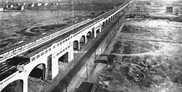
It is not a coincidence that the worst offenders – Gateway, East Side Access, and California High-Speed Rail – involve mainline rail. American and Canadian passenger railroads tend to be technologically and managerially conservative. Most still involve conductors punching commuter tickets as they did in the 1930s; for my NYU presentation, I found this picture from 1934.
I suspect that this comes from a Make Railroading Great Again attitude. Old-time railroaders intimately understand the decline of mainline rail in the United States in the middle third of the 20th century, turning giants like the Pennsylvania Railroad into bankrupt firms in need of federal bailouts. This means that they think that what needs to be done is in line with what the railroads wanted in the 1920s, 30s, 40s, and 50s. Back then, people lived in the suburbs and commuted downtown at rush hour, so there was no need for intra-suburban service, for in-city stops (those were for working- and middle-class city residents, not rich suburbanites in Westchester), or for high off-peak frequency. There was no need for cooperation between different railroads then, since commuters would rarely need to make an onward connection, which led to a culture encouraging competition over cooperation.
Among all the explanations for high construction costs, turf battles is the single most optimistic. But Americans should be optimistic about building cost-effective passenger rail. If this is the main culprit – and it is in the Bay Area, and one of several big culprits in New York – then all it takes to fix the cost problem is bringing organizational practices to the 21st century, which is cheap. It is too late for East Side Access, but it is possible to drastically reduce the cost of Gateway by removing unnecessary items such as Penn Station South. This can be repeated for smaller projects in the San Francisco Bay Area and everywhere in the US where two separate transit agencies fight over station space.
Am I optimistic that Americans will actually do this? I am not. Even outfits that should know better (again, the RPA) seem too conservative and too politically constrained; the RPA is proposing systemwide integration in its Fourth Plan, but in a way that incorporates each player’s wishlist rather than in a way that uses integration to reduce capital investment needs. In California, the HSR Authority seems to be responding to demands for value engineering by procrastinating difficult decisions, and it comes down to whether in the moment of truth it will have politicians in the state and federal governments who are willing to pay billions of dollars of extra money.
However, I do think that a few places might be interested in running public transit better. Americans are not incorrigible, and can learn to adapt best industry practices from other countries, given enough pressure. From time to time, there is enough pressure, it’s just not consistent enough to ensure the entire country (or at least the most important transit cities, led by New York) modernizes.
The RPA’s Fourth Regional Plan
The RPA has just put up its Fourth Regional Plan, recommending many new subway and commuter rail lines in New York, ranging from good (125th Street subway, Brooklyn-Lower Manhattan regional rail) to terrible (Astoria Line extension to the west rather than to LaGuardia, which gets a people mover heading away from Manhattan). I have a poll for Patreon supporters for which aspects I should blog about; I expect to also pitch some other aspects – almost certainly not what I said in my poll – to media outlets. If you support me now you can participate in the poll (and if you give $5 or more you can see some good writings that ended up not getting published). If you want to be sneaky you can wait a day and then you’ll only be charged in January. But you shouldn’t be sneaky and you should pledge today and get charged tomorrow, in December.
It’s hard to really analyze the plan in one piece. It’s a long plan with many components, and the problems with it don’t really tell a coherent story. One coherent story is that the RPA seems to love incorporating existing political priorities into its plan, even if those priorities are bad: thus, it has the AirTrain LaGuardia, favored by Cuomo, and the Brooklyn-Queens Connector (BQX), favored by de Blasio, and even has tie-ins to these plans that don’t make sense otherwise. Some of the regional rail money wasters, such as Penn Station South and the new East River tunnels from Penn Station to the LIRR, come from this story (the LIRR is opposed to any Metro-North trains going to Penn Station under the belief that all slots from points east to Penn Station belong to Long Island by right). However, there remain so many big question marks in the plan that are not about this particular story that it’s hard to make one criticism. I could probably write 20,000 words about my reaction to the plan, which is about 15 published articles, and there are, charitably, 5 editors who will buy it, and I’m unlikely to write 10 posts.
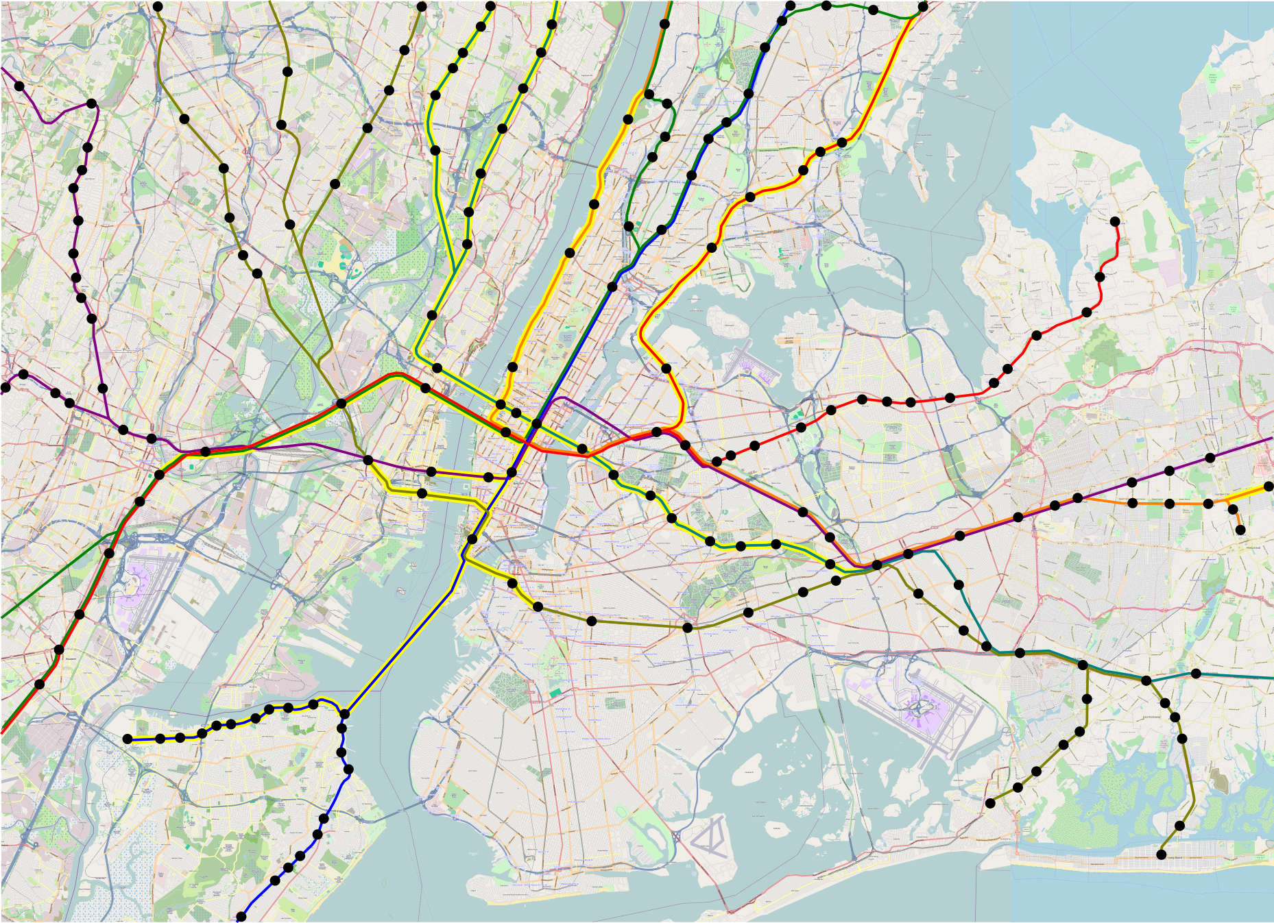
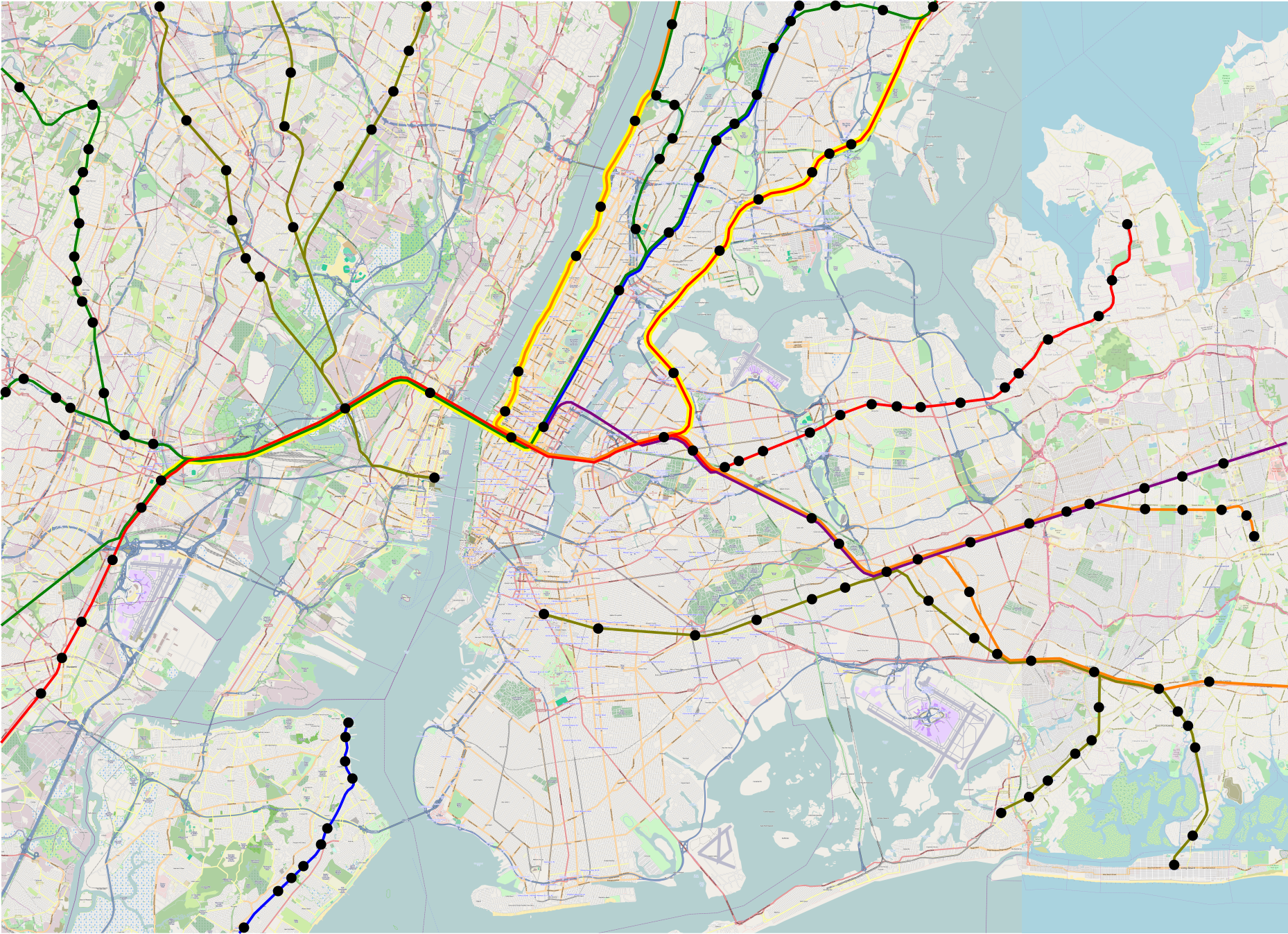
I’ll wait to see how the poll on Patreon goes, and what editors may be interested in. There are interesting things to say about the plan – not all negative – in areas including rail extensions, transit-oriented development, and livable streets. But for now, I just want to zoom in on the crayon aspects. I previously put up my 5-line map (4 MB version, 44 MB version). The RPA proposal includes more tunnels, for future-proofing, and is perhaps comparable to a 7-line map I’ve been working on (4 MB version, 44 MB version):
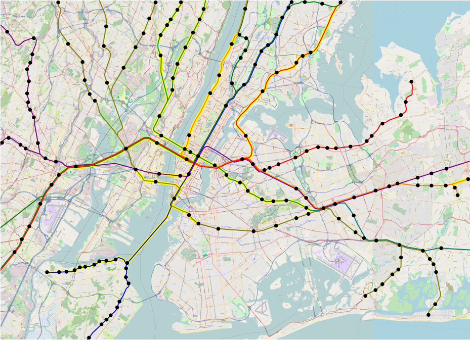
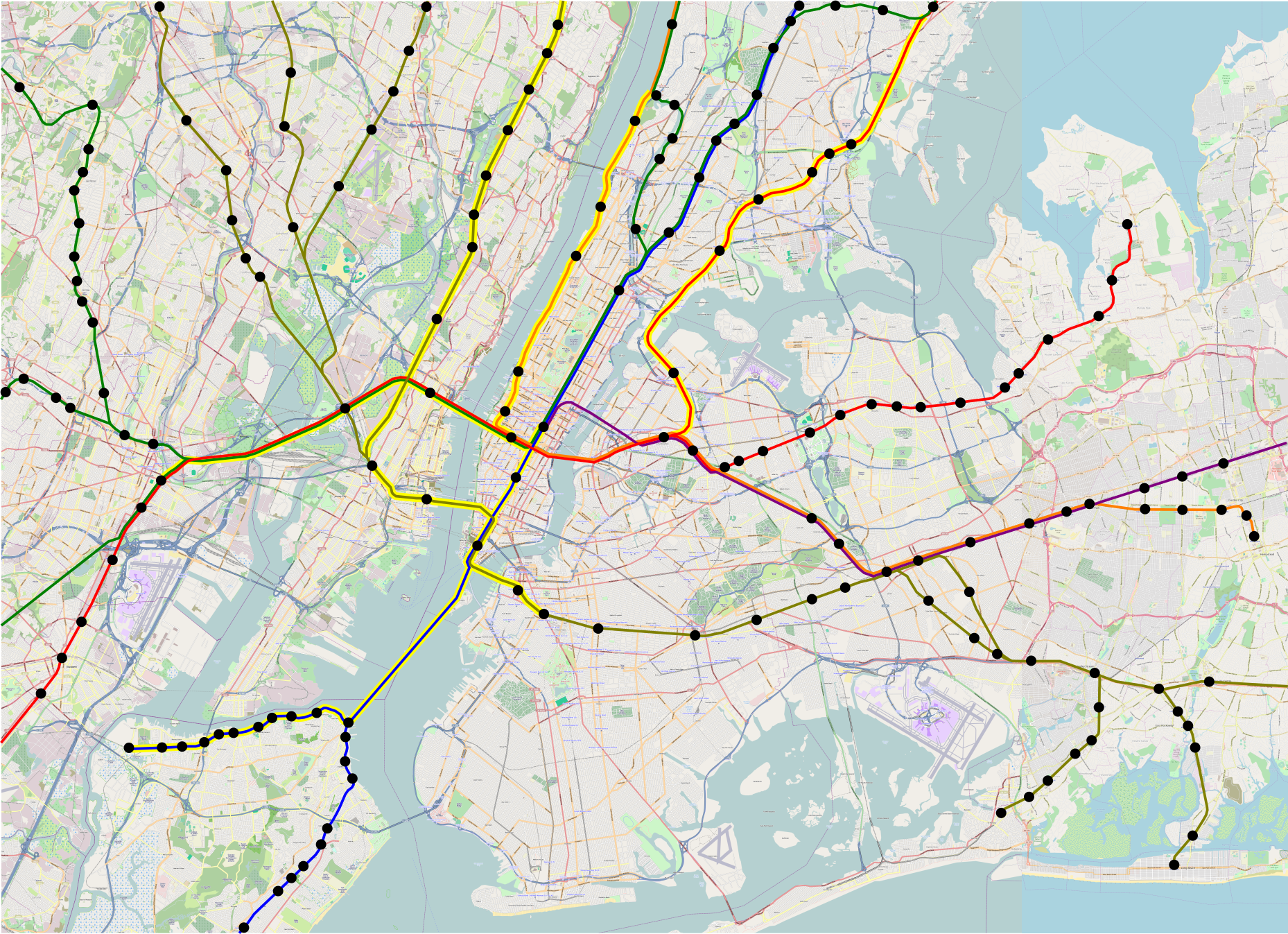
I was mildly embarrassed by how much crayon I was proposing, which is why what I put in my NYU presentation 3 weeks ago was the 5-line system, where Line 1 (red) is the Northeast Corridor and the Port Washington Branch, Line 2 (green) is much the same but through the new Hudson tunnels, Line 3 (orange) is the Empire Connection and the Hempstead Branch, Line 4 (blue) connects the Harlem Line and Staten Island, Line 5 (dark yellow) connects the Erie Lines with the Atlantic Branch and Babylon Branch, and Line 6 (purple) is just East Side Access. In the 7-line system, Line 6 gets extended to Hoboken and takes over the Morris and Essex Lines, and Line 7 (turquoise) connects the Montauk Line with the Northern Branch and West Shore Line via 43rd Street, to prune some of the Line 5 branches.
With all this extra tunneling, the map has 46 new double-track-km of tunnel. With just Lines 1-5, it has 30; these figures include Gateway and the other tunnels highlighted in yellow (but not the highlighted at-grade lines, like Lower Montauk), but exclude East Side Access. In contrast, here’s what the RPA is proposing:
Counting the Triboro-Staten Island tunnel and Gateway starting from the portal (not at Secaucus as the map portrays), this is 58 route-km, and about 62 double-track-km of tunnel (the Third Avenue trunk line needs four tracks between 57th and Houston at a minimum), for substantially the same capacity. The difference is that the RPA thinks Metro-North needs two more tracks’ worth of capacity between Grand Central and 125th, plus another two-track tunnel in the Bronx; from Grand Central to Woodlawn, the Fourth Regional Plan has 19 km, slightly more than 100% of the difference between its tunnel length and mine. My plan has more underwater tunnel, courtesy of the tunnel to Staten Island, but conversely less complex junctions in Manhattan, and much more austere stations (i.e. no Penn Station South).
As I said, I don’t want to go into too much detail about what the RPA is doing, because that’s going to be a series of blog posts, most likely a series of Streetsblog posts, and possibly some pieces elsewhere. But I do want to draw a contrast between what the RPA wants for regional rail and what I want, because there are a lot of similarities (e.g. look at the infill on the Port Washington Branch in both plans), but some subtle differences.
What I look for when I think of regional rail map is an express subway. I’ve been involved in a volunteer effort to produce a regional rail plan for Boston, with TransitMatters, in which we start by saying that our plan could be a second subway for Boston. In New York, what’s needed is the same, just scaled up for the city’s greater size and complexity. This means that it’s critical to ensure that the decision of which lines go where is, for lack of a better word, coherent. There should be a north-south line, such as the Third Avenue trunk in the Fourth Regional Plan or my Line 4; there should be an east-west line, such as the lines inherited from the legacy Northeast Corridor and LIRR; and so on.
The one big incoherence in my plan is the lack of a transfer station between Line 4/6 and Line 1/3 at Madison and 33rd. This is on purpose. Line 2 connects Penn Station and Grand Central, Madison/33rd is well to the south of Midtown’s peak job density, and Lines 4 and 6 shouldn’t be making more stops than the 4 and 5 subway lines, which go nonstop between Grand Central and Union Square.
The other weirdness is that in the 7-line system, unlike the 5-line system, there is no way to get between the Northern Branch or the West Shore Line and the rest of New Jersey without going through Manhattan. In the first map of this system that I made on my computer, Line 7 has an awkward dip to serve the same Bergenline Avenue station as Line 2. But I think what I posted here, with two separate stations, is correct: Lines 6 and 7 are lower priorities than a subway under Bergenline Avenue, which would make intra-state connections much easier. It’s difficult to depict rail extensions at different scales on one geographically accurate map, and doing a schematic map like the London Underground isn’t useful for depicting new lines, which should make it clear to readers where they go. But the 7-line system must be accompanied by subway extensions, some covered by the RPA (Utica, Nostrand) and some not (Bergenline, again).
I recently had to give a short description of my program for good transit, and explained it as, all aspects of planning should be integrated: operations and capital planning, buses and light rail and subways and regional rail, infrastructure and rolling stock and scheduling, transit provision and development. When I make proposals for regional rail, they may look out there, but the assumption is always that there’s a single list of priorities; the reason I depict a 7-line map, or even a 9-line map (in progress!), is to be able to plan lines 1-3 optimally. Everything should work together, and if agencies refuse to do so, the best investment is to make sure those agencies make peace and cooperate. The RPA plan sometimes does that (it does propose some regional rail integration), but sometimes it’s a smörgåsbord of different politically-supported proposals, not all of which work together well.
Suburban Transit-Oriented Development
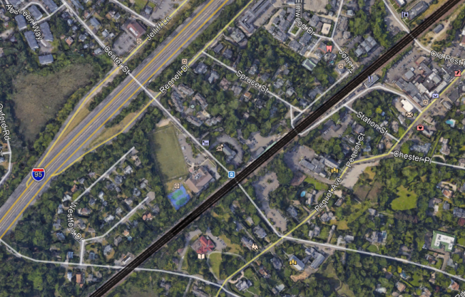
Here’s a Google Maps image of Southport, a section of Fairfield, Connecticut with its own Metro-North commuter rail station:
Here’s an image at the same scale of Bourg-la-Reine, an inner suburb of Paris on the RER B, at the junction between the line’s two southern branches:
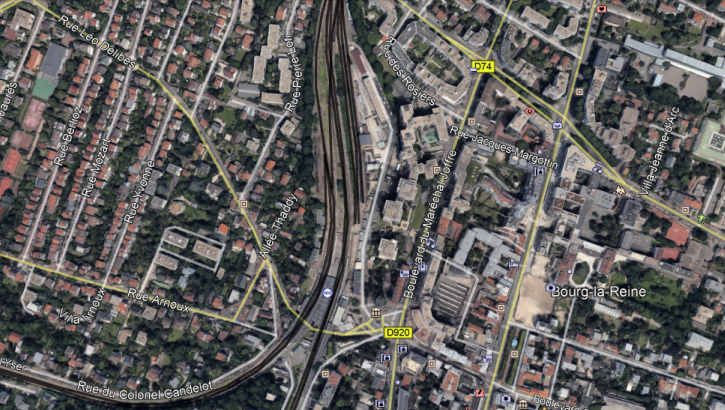
At Bourg-la-Reine, the buildings just east of the station are high-rise. There are local community amenities, including walkable schools, supermarkets, and pharmacies, and people can comfortably live in this suburb without a car. This generates significant RER traffic at all hours of day: outbound trains are often standing-room only until they reach this station even in midday, outside rush hour.
At Southport, there are a few townhouses near the station. But the roads are wide and hostile to pedestrians, and the nearest supermarket closes at 6 pm, too late for commuters returning from the city. Car ownership approaches 100%, and nobody rides the trains except to get to office jobs at the traditional peak hour in Manhattan (or perhaps Stamford).
The difference between the two places is so stark that they can barely be compared. Southport has 317 inbound boardings per weekday. Of those, 263, or 83%, are in the morning rush hour; the Metro-North-wide average is 63%, and the average on the SNCF-operated parts of the RER and Transilien is about 46%. Bourg-la-Reine has 4.5 million annual riders, about 16,000 on an ordinary working day.
A huge part of the difference is about service provision – Bourg-la-Reine has a train every five minutes midday, Southport a train every hour. But it’s not just about service. The RER has stations farther out, with somewhat less intense service, such as a train every 15 minutes, with comparable ridership. And the LIRR and Metro-North have little off-peak ridership even at stations with more frequent service, such as Mineola and Hicksville. Transit-oriented development (TOD) is as important as good service in such cases.
I bring up Southport because the RPA just dropped a study about suburban TOD that grades every New York commuter rail station between 0 and 3, and gives Southport the highest mark, 3. The RPA study looks at zoning within 800 meters of each station and considers whether there’s a parcel of land that permits multifamily housing with a floor are ratio higher than 1.25. Southport has such lots, supporting some townhouses, so according to the RPA it gets full marks, even though, by RER standards, it is like every other American car-oriented suburb.
Based on this methodology, the RPA identifies a number of good suburbs, and even comes to policy conclusions. It proposes more TOD in the mold of existing exurban New York examples, such as Patchogue. The model for the program is the real reason the RPA study is so weak: rather than calling into attention the big differences between land use at suburban stations in New York versus in Paris (or any number of big European cities with suburban rapid transit), it overfocuses on small differences within auto-oriented suburbia.
Some of the ultimate conclusions are not terrible. For example, the RPA is proposing linking federal infrastructure development to permitting more multifamily housing. This would improve things. However, the problem with this is twofold. First, it is unrealistic – the federal government gave up decades ago on enforcing fair housing laws, and has no interest in attempting to make exclusionary suburbs behave. Were I to propose this, hordes of American commenters would yell at me for not understanding American politics. And second, it misunderstands the nature of the problem, and ends up proposing something that, while unrealistic, is still low-impact.
The best way to understand the problem with the study is what author Moses Gates told me on Twitter when I started attacking it. He said that the RPA was looking at zoning rather than actual development. Since there is zoning permitting multifamily development within the prescribed radius at Southport, it gets full marks. With my understanding of what good TOD looks like, I would be able to say that this is clearly so bad the methodology must be changed; on Twitter I suggested looking at zoning within 300 meters of the station rather than 800, since the highest-intensity development should be right next to the station. I also suggested looking at supportive nonresidential uses, especially supermarkets. A development that isn’t walkable to retail at reasonable hours is not TOD.
The RPA does not think in this language. It thinks in terms of internal differences within the US. Occasionally it deigns to learn from London, but London’s suburban development is auto-oriented by European standards (transit mode share in the London commuter belt is at best in the teens, often in the single digits). Learning from anywhere else in the world, especially places that don’t speak English, is too difficult. This means that the RPA could not reach the correct conclusion, namely, that there is no such thing as an American suburb with TOD. The only exception I can come up with in the United States involves Arlington, on the Washington Metro, and Arlington is no longer considered a suburb, but really a full-fledged city in a different state, like Jersey City.
The other thing the RPA missed is that it drew too large a radius. TOD at a train station should include townhouses 800 meters out – but it’s more important to include high-rise residential construction next to the train station and mid-rise apartment buildings 500 meters out. Giving American suburbs latitude to place TOD so far from the station means they will act like Southport and allow small amounts of multifamily housing out of the way, while surrounding the station itself with parking, a tennis court, and large single-family houses with private swimming pools. This is not hypothetical: suburbs in New Jersey have reacted to court rulings mandating affordable housing by permitting apartments at the edge of town, far from supporting retail and jobs, and keeping the town core single-family.
Because the RPA missed the vast differences in outcomes between the US and France, it missed some useful lessons:
- States should centralize land use decisionmaking rather than give every small suburb full autonomy.
- TOD doesn’t need to be fully mixed-use, but there should be some local retail right next to housing.
- Housing should be high-density right next to the station. A floor area ratio of 1.25 is not enough.
- Publicly-funded social housing should be next to train stations, in the city as well as in the suburbs, and this is especially important in expensive suburbs, which aren’t building enough affordable housing.
Without suburban TOD, any regional rail system is incomplete. I wish I could have covered it at my talk, but I didn’t have time. Good service needs to run to dense suburbs, or at least suburbs with dense development within walking distance of the station. It needs to extend the transit city deep into suburbia, rather than using peak-only commuter rail to extend the auto-oriented suburbs into the city.
I Gave a Talk About Regional Rail
I expect there will be writeups about the talk (e.g. on Streetsblog). But meanwhile, here are my slides (warning: 17 MB, because of pictures). These are identical to what was shown at the talk, with two differences: I fixed one small mistake (Fordham Road vs. Pelham Parkway), and I consolidated the pauses, so each slide is a page, rather than a few pages, each page adding a line.
There were light fantasy maps in the talk. Because of size, I’m not embedding them in the post. But there are links:
- Infill stops without new tunnels: low-res/3.5 MB, high-res/20 MB
- The 3-line system (Gateway and realigned Empire Connection): low-res/4 MB, high-res/44 MB
- The 5-line system (the Lower Manhattan lines): low-res/4 MB, high-res/44 MB
Yellow highlights around a line indicate it’s new; Gateway is highlighted in one direction since it’s an existing two-track line to be four-tracked. On the infill map, solid circles are existing stations, gray circles are planned stations, white circles are my suggestions for additional infill.
Little Things That Matter: Vertical Circulation
Chatelet-Les Halles has a problem with passenger circulation. It has exceedingly wide platforms – the main platforms, used by the RER A and B, are 17 meters wide – but getting between the platform level and the rest of the station runs into a bottleneck. There are not enough stairs and escalators between the platform and the mezzanine, and as a result, queues develop after every train arrival at rush hour. Similar queues are observed at the Gare du Nord RER platforms. The situation at Les Halles is especially frustrating, since it’s not a constrained station. The platforms are so wide they could very easily have four or even six escalators per access point flanking a wide staircase; instead, there are only two escalators, an acceptable situation at most stations but not at a station as important as Les Halles.
This is generally an underrated concern in the largest cities. In smaller cities, the minimum number of access points required for coverage (e.g. one per short subway platform, two per long platform) is enough even at rush hour. But once daily ridership at a station goes into the high five figures or the six figures, a crunch is unavoidable.
There are two degrees of crunch. The first, and worse, is when the capacity of the escalators and stairs is not enough to clear all passengers until the next train arrives. In practice, this forces trains to come less often, or to spread across more platforms than otherwise necessary; Penn Station’s New Jersey Transit platforms are that bad. The situation at Les Halles and Gare du Nord is a second, less bad degree of crunch: passengers clear the platform well before the next train arrives, but there’s nonetheless a significant queue at the bottom of the escalator pits. This adds 30-60 seconds to passenger trip times, a nontrivial proportion of total trip time (it’s a few percent for passengers within the city and inner suburbs). Avoiding even the less bad crunch thus has noticeable benefits to passengers.
The capacity of a horizontal walkway is 81 passengers per minute per meter of width (link, p. 7-10). This is for bidirectional travel. Unidirectional capacity is a little higher, multidirectional capacity a little lower. Subway platforms and passages are typically around 5 meters wide, so they can move 400 passengers per minute – maybe a little more since the big crunch is passengers heading out, so it’s unidirectional with a few salmons (passengers arrive at the station uniformly but leave in clumps when the train arrives). Busier stations often have exits at opposite ends of the platform, so it’s really 400*2 = 800. Queues are unlikely to form, since trains at best arrive 2 minutes apart, and it’s uncommon for a train to both be full and unload all passengers at one station.
An escalator step can be 60 cm, 80 cm, or 1 meter wide, with another 60 cm of handrail and gear space on both sides. On public transit, only the widest option is used, giving 1.6 meters of width. The theoretical capacity is 9,000 passengers per hour, but the practical capacity is 6,000-7,000 (link, p. 13), or 100-120 per minute. This is more than pedestrian walking capacity per unit of step width, but less per unit of escalator pit width. So a pedestrian walkway ending in a battery of escalators will have a queue, unless the width of the escalator bank is more than that of the walkway leading to it.
Moreover, escalators aren’t just at the end of the station. The busiest train stations have multiple access points per platform, to spread the alighting passengers across different sections of the platform. But mid-platform access points have inherently lower capacity, since they compete for scarce platform width with horizontal circulation. It appears that leaving around 2 meters on each side, and dedicating the rest to vertical circulation, is enough to guarantee convenient passenger access to the entire platform; in a crunch, most passengers take the first access point up, especially if there’s a mezzanine (which there is at Les Halles).
Should New York invest in better commuter rail operations, it will face a bigger risk of queues than Paris has. This is for two reasons. First, New York has much higher job density in Midtown than Paris has anywhere, about 200,000/km^2 vs. perhaps 100,000 around La Defense and the Opera (my figures for both areas in Paris have huge fudge factors; my figure for New York comes from OnTheMap and is exact). And second, Manhattan’s north-south orientation makes it difficult to spread demand across multiple CBD stations on many commuter rail lines. One of the underrated features of a Penn Station-Grand Central connection is that through-trains would have passengers spread across two CBD stops, but other through-running regional rail lines would not have even that – at best they’d serve multiple CBDs, with one Midtown stop (e.g. my line 4 here).
When I computed the needs for vertical circulation at a Fulton Street regional rail station in this post, I was just trying to avoid the worse kind of crunch, coming up with a way to include 16 platform-end escalators (12 up, 4 down in the morning peak) and 16 mid-platform escalators (8 up, 8 down) on a 300-meter long two-level station. It’s likely that the escalator requirement should be higher, to avoid delaying passengers by 1-1.5 minutes at a time. With four tracks (two on a Grand Central-Staten Island line, two on a Pavonia-Brooklyn line) and 12-car trains arriving every 2 minutes, in theory the station could see 240,000 incoming passengers per hour, or 4,000 per minute. In reality, splitting passengers between Grand Central and the Financial District on what I call line 4 means that a sizable majority of riders wouldn’t be getting off in Lower Manhattan. When I tried to compute capacity needs I used a limit passenger volume of 120,000 per hour, and given Midtown’s prominence over Lower Manhattan, even 90,000 is defensible.
90,000 per hour is still 1,500 per minute, or 3,000-4,000 if we are to avoid minute-long queues. A single up escalator is limited to about 100-120 people per minute, which means that twenty up escalators is too little; thirty or even forty are needed. This requires a wider platform, not for horizontal passenger circulation or for safety, but purely for escalator space, the limiting factor. I proposed an 8-meter platform, with space for four escalators per end (two ends per platform, two platforms on two different levels), but this suggests the tube diameter should be bigger, to allow 10-meter platforms and six escalators per end, giving four up escalators per end. This is 16 up escalators. Another 16-20 up escalators can be provided mid-platform: the plan for eight up escalators involved eight access points interspersed along the platform, and 10-meter platforms are wide enough width to include three escalators (two up, one down) per bank and on the border of allowing four (three up, one down).
The situation at the Midtown stations in New York is less constrained. Expected volumes are higher, but Grand Central and Penn Station both spread passengers among multiple platforms. In the near term, Penn Station needs to add more vertical circulation at the New Jersey Transit platforms. The LIRR remodeled its section of the station to add more access points in the 1990s (e.g. West End Concourse), but New Jersey Transit is only doing so now, as part of phase 1 of Moynihan Station, and it’s still not adding as many, since its platforms are shorter and don’t extend as far to the west.
Nonetheless, given the number of proposals out there for improving Penn Station, including ReThinkNYC and Penn Design’s plan, it’s important to think of longer-term plans for better vertical circulation. When I proposed eliminating Penn Station’s above-ground infrastructure, I came up with a design for six approach tracks (including a new Hudson tunnel connecting to Grand Central), each splitting into two platform tracks facing the same platform; the six platforms would each be 15 meters wide, but unlike Les Halles, each of six access points would have six escalators, four up and two down in the morning peak, or alternatively four escalators and a wide staircase (the climb is 13 meters, equivalent to a five-floor walkup). There would be ample capacity for anything; emptying a full 12-car train would take forty seconds, and it’s unlikely an entire 12-car train would empty.
Fare Integration
I said something on my Patreon page about fare integration between buses and trains, in the context of an article I wrote for the DC Policy Center about improving bus service, and got pushback of the most annoying kind, that is, the kind that requires me to revise my assumptions and think more carefully about the subject. The controversy is over whether fare integration is the correct policy. I still think it is, but there’s a serious drawback, which the positive features have to counterbalance.
First, some background: fare integration means that all modes of public transit charge the same fare within the same zone, or between the same pair of stations. Moreover, it means transfers are free, even between modes. Fare integration between city buses and urban rail seems nearly universal; big exceptions include Washington (the original case study) and London, and to a lesser extent Chicago. Fare integration between urban rail and regional rail is ubiquitous in Europe – London doesn’t quite have it, but it’s actually closer than fare integration between buses and the Underground – but does not exist in North America. In Singapore there is fare integration. In Tokyo, there are about twelve different rail operators, with discounted-but-not-free transfers between two (Tokyo Metro and Toei) and full-fare transfers between any other pair.
The reason North American commuter rail has no fare integration with other forms of transit is pure tradition: railroaders think of themselves as special, standing apart from mere urban transit. We can dispense with the idea that it is a seriously thought-out fare system. However, lack of integration between buses and trains in general does have some thought behind it. In London, the stated reason is that the Underground is at capacity, so its fares are jacked up to avoid overcrowding, while the buses remain cheap. In Washington, it’s that Metro is a better product than the buses, so it should cost more, in the same way first-class seats cost more than second-class seats on trains. Cap’n Transit made a similar point about this in the context of express buses.
There are really three different questions about fare integration: demand, supply, and network effects. The first one, as noted by Patreon supporters, favors disintegrated fares. The other two favor fare integration, for different reasons.
Demand just means charging more for a product that has higher demand. This is about revenue maximization, assuming fixed service provision: people will pay more for the higher speed of rapid transit, so it’s better to charge each mode of transportation the maximum it can bear before people stop taking trips altogether, or choose to drive instead. It’s related to yield management, which maximizes revenue by using a fare bucket system, using time of booking as a form of price discrimination; SNCF uses it on the TGV, and in its writeups for American high-speed rail from 2009, it said it boosted revenue by 4%. In either case, you extract from each passenger the maximum they can pay by making features like “don’t get stuck in traffic” cost extra.
Supply means giving riders incentives to ride the mode of transportation that’s cheaper to provide. In other words, here we don’t assume fixed (or relatively fixed) service provision, but variable service provision and relatively fixed ridership. Trains nearly universally have lower marginal operating costs than buses per passenger-km; in Washington the buses cost 40% more per vehicle-km, and perhaps 2.5 times as much per unit of capacity (Washington Metro cars are long). Using the fare system to incentivize passengers to take the train rather than the bus allows the transit agency to shift resources away from expensive buses, or perhaps to redeploy these resources to serve more areas. If anything, the bus should cost more. There are shades of this line in incentives some transit agencies give for passengers to switch from older fare media to smart cards: the smart card is more convenient and thus in higher demand, but it also involves lower transaction costs, and thus the agency incentivizes its use by charging less.
The network effect means avoiding segmenting the market in any way, to let passengers use all available options. The fastest way to get between two points may be a bus in some cases and a train in others, or a combined trip. This fastest way is often also the most direct, which both minimizes provision cost to the agency and maximizes passenger utility. This point argues in favor of free transfers especially, more so than fare integration. Tokyo fares are integrated in the sense that the different railroads charge approximately the same for the same distance; but transfers are not free, and monthly passes are station to station, with no flexibility for passengers who live between two parallel (usually competing) lines.
The dominant reason to offer integrated fares is network effects, more so than supply. Evidently, I am not aware of transit agencies that charge more for buses than for trains, only in the other direction. That fare integration allows transit agencies to reduce operating costs mitigates the loss of revenue coming from ending price discrimination; it is not the primary reason to integrate fares.
The issue at hand is partly frequency, and partly granularity. A typical transit corridor, supporting a reasonably frequent bus or a medium-size subway station, doesn’t really have the travel demand for multiple competing lines, even if it’s a parallel bus and a rail line. Fare disintegration ends up reducing the frequency on each option, sometimes beyond the point where it starts hurting ridership.
In Washington it’s especially bad, because of reverse-branching. The street network makes it hard for the same bus to serve multiple downtown destinations (or offer transfers to other buses for downtown service). Normally, riders would be able to just take a bus to the subway station and get to their destination, but Washington plans buses and trains separately, so two of the trunk routes, running on 14th an 16th Streets, reverse-branch. The hit to frequency (16-18 minutes per destination off-peak) is so great that even without fare integration it’s worthwhile to prune the branches. But such situations are not unique to Washington, and can occur anywhere.
The required ingredients are a city center that is large enough, or oriented around a long axis, with a street network that isn’t a strict grid and isn’t oriented around the axis of city center. New York is such a city: if it didn’t have fare integration, buses would need to reverse-branch from the north to serve the East Side and West Side, and from anywhere to serve Midtown and Lower Manhattan.
The granularity issue is that there isn’t actually a large menu of options for riders with different abilities to pay. This is especially a problem in American suburbs, with nothing between commuter rail (expensive, infrequent off- and reverse-peak, assumes car ownership) and the bus (in the suburbs, a last-ditch option for people below the poverty line). I wrote about this for Streetsblog in the context of Long Island; there’s also a supply angle – different classes of riders travel in opposite directions, so it’s more efficient to put them on one vehicle going back and forth – but this is fundamentally a problem of excessive market segmentation.
This also explains how Tokyo manages without fare integration between different rail operators. Its commuter rail lines are not the typical transit corridor. With more than a million riders per day (not weekday) on many lines, there is enough demand for very high frequency even with disintegrated fares. A passenger between two competing lines can only get a monthly pass on one, but it’s fine because the one line is frequent and the trains run on time.
The rest of the world is not Tokyo. Branches in Outer London and the Paris suburbs aren’t terribly frequent, and only hit one of the city centers, necessitating free transfers to distribute passengers throughout the city. They also need to collect all possible traffic, without breaking demand between different modes. If RER fares were higher than Metro fares, some areas would need to have a Metro line (or bus line) paralleling the RER, just to collect low-income riders, and the frequency on either line would be weaker.
The demand issue is still real. Fare integration is a service, and it costs money, in terms of lost revenue. But it’s a service with real value for passengers, independently of the fact that it also reduces operating costs. The 99.5% of the world that does not live in Tokyo needs this for flexible, frequent transit choices.
Future Los Angeles Metro Investments
I just put up an article on Urbanize complaining about Los Angeles’s uniquely high operating costs on the subway and light rail. In the article, I offered a few explanations, but also said that none of them seems satisfying: high wages (wages are as high in Chicago), low frequency (frequency is as low in Atlanta), low train operator efficiency (the gap with London is too small), few lines with two different technologies (Atlanta has just two lines and Miami one).
Long-time readers may be used to my sneering at American transit operations for being primitive compared with European ones, but here, the best American system (Chicago) outperforms the four Western European systems for which I have data, and one more (Philadelphia) is within those four European systems’ range. Per car-km, Chicago spends $5 in operating costs, London/Paris/Berlin $6, Philadelphia and Madrid $7, New York $9-10, and Los Angeles $12.
So Los Angeles is special. Lisa Schweitzer suggests my discounting the frequency and system size explanations is in error, and when I brought up Atlanta on social media, she noted that Atlanta’s labor costs are lower than Los Angeles’s. Assuming this is correct (Southern California uniquely combines high nominal wages with a tiny subway network), Los Angeles should expect subway operating costs to come down as it builds its urban rail network. Some lines, like the Regional Connector, the Wilshire subway, and the Crenshaw light rail line, are already under construction. But as the system grows (especially the subway system, which is technologically incompatible with the light rail lines, even the fully grade-separated Green Line), average operating costs will fall, which suggests that marginal operating costs are low. If Los Angeles has not figured this into its calculation, this means that the finances of future subway lines are better than projected.
I drew this map of what rapid transit Los Angeles should build. The map isn’t new, but I want to use it to explain how I think cities should be building subways.
1. Every line is rapid transit, even lines built out of light rail lines today, like the Blue Line and the Expo Line. Unprotected grade crossings and street running, even in dedicated tracks, limit capacity and reliability elsewhere down the line, even though they do not reduce speed on other segments of the line. The Orange Line is replaced by a subway, not light rail.
2. Branching is rare. Only three subway lines branch. Two tunnel through Sepulveda Pass (where Let’s Go LA suggests four branches on each side of the tunnel), with each line branching into two in the north, in the Valley, where demand on each corridor is lower. The third is on Vermont, with a branch west to Torrance.
3. Many lines run elevated, in less dense areas with very wide streets. South Vermont is this south of Gage. This also includes the four north-south lines in the San Fernando Valley heading from the Sepulveda tunnel.
4. There are three distinct regional rail lines, all electrified, with two through-running; the branch to the airport is elevated. One branches, the others don’t. Local and express trains could happen, but the acceleration and reliability boosts from electrification are so great that speeds in the 70-80 km/h range are possible even with all the infill stops. The line to LAX could also host some intercity trains, provided it has four tracks. The dark blue line, labeled the I-5 line, should have four tracks at the very least on the shared segment, and likely longer, for planned high-speed rail; some of the work is already being done, but there is still going to be track sharing with freight trains.
5. The system is really a hybrid of a typical radial rail system and a grid, like the Mexico City Metro. There are fifteen lines, including commuter rail; eight, including the commuter lines, serve the CBD. Some (the Pink, Orange, and Atlantic Lines, and the southern half of the Green Line) are fully circumferential, the others (Harbor/Azure, Red, Crenshaw/Brown) serve secondary CBDs and try to avoid being too much like bad combinations of radial and circumferential transit. The reason for this structure is that Los Angeles has very strong secondary centers, including Century City, Burbank, El Segundo, Santa Monica, and Koreatown.
6. Much of the system assumes reasonable upzoning, for example the northern extension of the West Santa Ana/Lime Line to La Crescenta and Sun Valley. This includes replacing single-family zoning with multifamily zoning everywhere, and building up CBDs at major connection points such as Vermont/Wilshire and El Segundo.
7. There is a lot of service in LA County, but not much in the other counties except lines to the CBD. It’s possible to build up a fuller system in Orange County, extending the Purple Line east and also adding some grid routes, assuming extensive residential upzoning everywhere and commercial upzoning in Santa Ana, Anaheim, and the beach cities.
8. At LA construction costs (about $400-500 million per km underground), the entire map should be doable for maybe $90 billion; at reasonable costs, make it $40 billion. LA is spending comparable amounts of money on transportation out of the recent ballot measures, it just spends a lot of it on operational waste, on BRT (the current plans for Vermont are BRT, even though the corridor is busy enough to deserve a subway), or on roads.
Infrastructure for Mature Cities
A post by Aaron Renn just made me remember something I said in the Straphangers Campaign forum ten years ago. I complained that New York was building too little subway infrastructure – where were Second Avenue Subway, Utica, Nostrand, various outer extensions in Queens and the Bronx that we crayonistas liked? Shanghai, I told people in the forum, was building a lot of subway lines at once, so why couldn’t New York? The answer is not about construction costs. Ten years ago, China’s construction costs relative to local incomes were about the same as those of New York; even today, the difference is small. Rather, it is that China is a fast-growing economy that’s spending a lot of its resources on managing this growth, whereas the US is a mature economy without infrastructure problems as urgent as those of developing countries.
Aaron posits that American cities are too conservative, in the sense of being timid rather than in the sense of being on the political right. He gives examples of forward-looking infrastructure projects that New York engaged in from the early 19th century to the middle of the 20th century: the Manhattan grid, the Erie Canal, the Croton Aqueduct, the subway, the Robert Moses-era highways and parks. Today, nothing of the sort happens. Aaron of course recognizes that “New, rapidly growing cities need lots of new infrastructure and plans. Mature cities need less new infrastructure.” The difference is that for me, this is where this line of questioning ends. New York is a mature city, and doesn’t need grand plans; it needs to invest in infrastructure based on the assumption that it will never again grow quickly.
If not grand plans like building the Manhattan grid far beyond the city’s then-built up area, then what should a mature city do? Aaron talks about dreaming big, and there is something to that, but it would take a profoundly different approach from what New York did when its population grew by 50% every decade. I stress that, as with my last post critiquing another blog post, I agree with a substantial part of what Aaron says and imagine that Aaron will treat many of the solutions I posit here as positive examples of thinking big.
Rationalization of Government
Mature societies have accumulated a great deal of kludge at all levels, coming from social structures and government programs that served the needs of previous generations, often with political compromises that are hard to understand today. Welfare programs are usually a kludge of different social security programs (for the disabled, for retirees, for various classes of unemployed people, sometimes even for students), housing benefits, reduced tax rates for staple goods like food, child credit, and in the US food stamps. A good deal of the impetus for basic income is specifically about consolidating the kludge into a single cash benefit with a consistent effective marginal tax rate.
In transportation, bus networks have often evolved incrementally, with each change making sense in local context. When a new housing development opened, the nearest bus would be extended to serve it. In Israel, which grew late enough to grow around buses and not rail, this was also true of dedicated industrial zones. In cities that used to have streetcar networks, some buses just follow the old streetcar routes; the Washington bus system even today distinguishes between former streetcars (which have numbers) and routes that were never streetcars (which use letters). Jarrett Walker‘s bus network redesigns are partly about reorganizing such systems around modern needs, based on modern understanding of the principles behind transit ridership.
Governance often needs to be rationalized as well. In the early 20th century, it was important to connect outlying neighborhoods to city center, and connections between lines were less important. This led to excessively radial surface transit (rapid transit is always radial), but also to rail lines that don’t always connect to one another well. Sometimes due to historical contingency the lines are run by separate agencies and have uncoordinated schedules and different fare systems charging extra for transfers. Occasionally even the same agency charges for bus-rail transfers, often because of a history of separate private operators before the public takeover. In the US and Canada, the special status of commuter rail, with different unions, fares, schedules, and management is of particular concern, because several cities could use commuter rail to supplement the rest of the transit network.
In New York, this points toward the following agenda:
- Modernization of commuter rail, with full fare integration with the subway and buses, proof-of-payment fare collection to reduce operating costs, high off-peak frequency on the local lines, and through-running where there is infrastructure for it (i.e. Penn Station).
- Some bus service reorganization. New York already has extensive frequent buses, but some of its network is still questionable, for example some branches of the Third/Lexington and Madison/Fifth one-way pairs in Harlem.
- Subway reorganization. The subway branches too much, and at several places it could have higher capacity if it reduced the extent of reverse-branching; see discussion here and in comments here. Some elevated lines could also see their stops change to support better transfers, including the J/M/Z at Broadway and Manhattan to transfer to the G, and maybe even the 7 at 108th Street to enable a transfer to a straightened Q23 bus.
- Fare integration with PATH, and demolition of the false walls between the PATH and the F/M trains on Sixth Avenue, to enable cross-platform transfers.
Serve, Don’t Shape
There are two models for building new infrastructure: serve, and shape. Serve means focusing on present-day economic and demographic patterns. Shape means expecting the project to change these patterns, the “build it and they will come” approach. When New York built the 7 train to Flushing, Flushing already existed as a town center but much of the area between Long Island City and Flushing was open farmland. I’ve argued before that third-world cities should use the shape model. In contrast, mature cities, including the entire developed world except a few American Sunbelt cities and analogs in Canada and Australia, should use the serve model.
The serve model flies in the face of the belief that public transit can induce profound changes in urban layout. In reality, some local transit-oriented development is possible, but the main center of New York will remain Midtown; so far Hudson Yards seems like a flop. In the suburbs, more extensive redevelopment is possible, with apartment buildings and mixed uses near train stations. But these suburbs, built after WW2, are less mature than the city proper. In fast-growing cities in North America outside the traditional manufacturing belt the shape model still has validity – Vancouver, still a relatively new city region in the 1980s, got to shape itself using SkyTrain. But in New York, there is no chance.
This also has some ethnic implications. Jarrett likes to plan routes without much regard for social circumstances, except perhaps to give more bus service to a lower-income area with lower car ownership. But in reality, it is possible to see ethnic ties in origin-and-destination transit trips. This is why there are internal Chinatown buses connecting Chinatown, Flushing, and Sunset Park, and a bus connecting two different ultra-Orthodox neighborhoods in Brooklyn. In Washington, there is origin and destination data, and there are noticeable ties between black neighborhoods, such as Anacostia and Columbia Heights.
In a mature city with stable ethnic boundaries (Harlem has been black for ninety years), it is possible to plan infrastructure around ethnic travel patterns. This means that as New York disentangles subway lines to reduce branching, it should try choosing one-seat rides that facilitate known social ties, such as between Harlem and Bedford-Stuyvesant. While New York’s ethnic groups are generally integrated, this has special significance in areas with a mixture of linguistic or religious groups with very little intermarriage, such as Israel, which has two large unassimilated minorities (Arabs, and ultra-Orthodox Jews); Israeli transportation planning should whenever possible take into account special ultra-Orthodox travel needs (e.g. large families) and intra-ethnic connections such as between Bnei Brak and Jerusalem or between Jaffa and Nazareth.
Integrated Planning
A few years ago, I wrote a post I can no longer find talking about building the minimum rail infrastructure required for a given service plan. In comments, Keep Houston Houston replied that no, this makes it really difficult to add future capacity if demand grows. For example, a single-track line with meets optimized for half-hourly service requires total redesign if demand grows to justify 20-minute frequency. In a growing city, this means infrastructure should be planned for future-proofing, with double track everywhere, no reliance on timed overtakes, and so on. In a mature city, this isn’t a problem – growth is usually predictable.
It is relatively easy to integrate infrastructure planning and scheduling based on today’s travel patterns, and impossible to integrate them based on the future travel patterns of a fast-growing city such as Lagos or Nairobi. But in a slow-growing city like New York, future integration isn’t much harder than present-day integration. Alone among North American cities, New York has high transit mode share, making such integration even easier – transit usage could double with Herculean effort, but there is no chance that a real transit revival would quadruple it or more, unlike in cities that are relatively clean slates like Los Angeles.
Since the mature city does not need too much new infrastructure, it is useful to build infrastructure to primarily use existing infrastructure more efficiently. One example of this is S-Bahn tunnels connecting two stub-end lines; these are also useful in growing cities (Berlin built the Stadtbahn in the 1880s), but in mature cities their relative usefulness is higher, because they use preexisting infrastructure. This is not restricted to commuter rail: there is a perennial plan in New York to build a short tunnel between PATH at World Trade Center and the 6 train at City Hall and run through-service, using the fact that PATH’s loading gauge is similar to that of the numbered subway lines.
In New York, this suggests the following transit priorities:
- Open commuter rail lines and stations based on the quality of transfers to the subway and the key bus routes. For example, Penn Station Access for Metro-North should include a stop at Pelham Parkway for easy transfer to the Bx12 bus, and a stop at Astoria for easy transfer to the subway.
- Investigate whether a PATH-6 connection is feasible; it would require no new stations, but there would be construction difficulties since the existing World Trade Center PATH station platforms are in a loop.
- Change subway construction priorities to emphasize lines that reduce rather than add branching. In particular, Nostrand may be a higher priority than Utica, and both may be higher priorities than phases 3 and 4 of Second Avenue Subway. A subway line under Northern Boulevard in Queens may not be feasible without an entirely new Manhattan trunk line.
- Build commuter rail tunnels for through-running. The Gateway project should include a connection to Grand Central rather than Penn Station South, and should already bake in a choice of which commuter lines on each side match to which commuter lines on the other side. Plan for commuter rail lines through Lower Manhattan, connecting the LIRR in Brooklyn with New Jersey Transit’s Erie Lines, and, accordingly, do not connect any of the lines planned for this system to Penn Station (such as with the circuitous Secaucus Loop in the Gateway project).
Conclusion
New York still needs infrastructure investment, like every other city. Such investment requires thinking outside the box, and may look radical if it forces different agencies to cooperate or even amalgamate. But in reality the amount of construction required is not extensive. More deeply, New York will not look radically different in the future from how it looks today. Technological fantasies of driverless flying cars aside, New York’s future growth is necessarily slow and predictable, and cities in that situation need to invest in infrastructure accordingly.
In my post about third-world transit, I posited an epistemological principle that if the presence of a certain trait makes a certain solution more useful, then the absence of the trait should make the solution less useful. The shape vs. serve argument comes from this principle. The same is true of the emphasis on consolidating the kludge into a coherent whole and then building strategically to support this consolidation. A fast-growing city has no time to consolidate, and who’s to say that today’s consolidation won’t be a kludge in thirty years? A mature city has time, and has little to worry about rapid change obsoleting present-day methods.
But at the same time, the same epistemology means that these changes are less critical in a mature city. In the third world, everything is terrible; in the first world, most things are fine. New York’s transportation problems are painful for commuters, but ultimately, they will not paralyze the city. It will do well even if it doesn’t build a single kilometer of subway in the future. Nothing is indispensable; this means that, in the face of high costs, often the correct alternative may be No Build. This illustrates the importance of improving cost-effectiveness (equally important in the third world, but there the problem is the opposite – too many things are indispensable and there isn’t enough money for all of them).
I emphasize that this does not mean transportation is unimportant. That New York will not be destroyed if it stops building new infrastructure does not mean that new infrastructure is of no use for the city. The city needs to be able to facilitate future economic and demographic growth and solve lingering social problems, and better infrastructure, done right, can play a role in that. New York will most likely look similar in 2067 to how it looks in 2017, but it can still use better infrastructure to be a better and more developed city by then.