Category: Urban Transit
When are Express Trains Warranted? Part 2: Subways
Last week, I wrote about which regional rail lines should run local and express trains and which should only run locals. I gave various guidelines, specific to that mode of transportation. The same question makes a lot of sense for subways (or elevated lines), and is especially important for large cities building new metro networks, typically in developing countries. The key difference is that subway trains almost always run so frequently that the only way to have local and express services is to build four-track mainlines, like in New York. So really, this is a question about when it’s useful to build four-track subways instead of two-track subways.
Costs
The cost of a four-track subway is higher than that of a two-track subway. However, the difference depends on the method of construction. Cut-and-cover four-track subways do not appear to be much more expensive than two-track subways; in the 1900s, New York had little to no cost premium over London or Paris. The First Subway’s underground segments, slightly less than half of which are four-track, cost $39 million per km in today’s money, compared with about $29 million per km in Paris in the same era (see sources in this post). The Metropolitan line in London cost about the same: £1.3 million for 6 km in the early 1860s, or about $30 million per km.
In contrast, boring four tracks appears to cost twice as much as boring two. It’s hard to find examples, since four-track bores are extremely rare; the examples I do know, such as the East River Tunnels and the tunnel carrying the Lexington Avenue Line under the Harlem River, are short. There are bound to be efficiencies in engineering and sitework reducing the cost of boring, just as there are with cut-and-cover, but the majority of the cost of tunneling is the boring and the systems. The majority of the rest is stations, and the local stations can be built for not much of a premium over stations on a two-track line, but the express stations require considerably more excavation.
What this means is that cities that build cut-and-cover should probably aim to build four tracks rather than two. In retrospect, Paris should have built Metro Line 1 with four tracks: the narrowest street segment, Rue de Rivoli, runs for 3 km and is about 20-23 meters wide, which can take four tracks if there are only local platforms, and everything else is at least 30 meters and could take four tracks and express platforms. The only express station under Rivoli would probably be Chatelet, where there is a wide square where the station footprint could expand.
The question of whether to use cut-and-cover today is a separate issue. It’s easier for the first few lines than for subsequent lines, which have to cross under the old lines. Nonetheless, it’s still in use, for example in China; the lack of express tracks on Chinese subways has led to criticism on some railfan forums, particularly by Japanese railfans, who are used to the fast express trains of the JRs through urban areas. But in India, the longest underground segment in Delhi, on the Yellow Line, appears to be bored, running deep under Old Delhi. The one potential pitfall is that bored tunnels, while generally more expensive to construct than cut-and-cover tunnels if wide streets are available, are nimbler, making it easier to build lines to high standards, with wide curves.
Benefits
The two obvious benefits of express subways are speed and capacity. New York averages a decent speed, just under 30 km/h, buoyed by express trains that average about 36 km/h. When frequency on both the local and express tracks is adequate, which it regrettably isn’t most of the time in New York, it’s possible to use cross-platform local/express transfers to improve trip times even for people on the local stations.
The capacity benefits are sometimes compromised by transfers. In New York, the express tracks are consistently more crowded than the local tracks on the main lines, and the Upper West Side in particular sees the city’s most overcrowded trains on the express tracks run alongside the second least crowded on the local tracks. However, on the East Side, the local and express trains under Lexington are both quite full. The number of passengers they carry would overwhelm any two-track line: to carry the same number of passengers on just two tracks at the current peak frequency, each train would need about 2,100 passengers, more per unit of train floor area than the most crowded Tokyo Metro lines.
There are also indirect effect of four-tracking. The most distant stations are presumably express-only, or, if not, passengers will transfer to an express train at the first opportunity. This means that adding local stops does not increase trip times for passengers far out, which in turn argues in favor of tighter stop spacing on local trains, to provide more coverage. Evidently, New York has one of the smallest interstations (on local trains) of any major metro network in the world, surpassed only by Paris, which built the Metro without regard for the suburbs. Second Avenue Subway, built with just two tracks, has wider stop spacing than other Manhattan north-south mainlines, missing 79th Street, with the planned phase 2 stopping at 106th instead of 103rd and 110th.
Network effects
I have hammered repeatedly that metro systems need to avoid three pitfalls of network planning:
- Tangential lines, starting as radial farther out but becoming circumferential closer in rather than staying radial and serving city center.
- Reverse-branching: a common trunk in an outlying area splitting into branches in city center, the opposite of the more normal branching arrangement.
- Missed connections, in which two lines intersect without a transfer.
It is easier to miss connections when the stop spacing is wider, because city centers are so small that line 1 can easily miss the road that line 6 will later run under. The Paris Metro has just one missed connection (M5/M14), and the city made a failed effort in the 1900s to bring Line 5 to what would be the transfer station, Gare de Lyon. New York has only two missed connections among the lines built from 1900 to the 1920s (Junius/Livonia on the 3/L, Bowling Green/Whitehall on the 4-5/RW), both of which are easy to fix; the city’s tens of misses come from a deliberate decision to avoid transfers in the lines built in the 1930s. Systems with wider stop spacing have more opportunities for missed connections, such as Tokyo, Shanghai, and Moscow.
Four-track mainlines short-circuit this problem doubly. First, fewer lines are required to provide the same coverage and capacity. On the eve of the Great Depression, New York had six subway mainlines, three with four tracks and three with two, and 2 billion annual riders. Even if a city insists that all transfer stations be express (which is the case in New York among lines built before the 1930s, though at one station express platforms were only retrofitted decades later), there are fewer potential intersections; at city center, even the express lines are unlikely to have very wide stop spacing.
Moreover, it’s fine to miss transfers on express lines. The reason missed connections are so bad is that the alternative option typically requires a three-seat ride. For example, the 1 passes between Columbus Circle-59th Street and 50th Street without a connection to the E train, leaving connecting passengers with one of two options: ride to Times Square and transfer there, which is both a detour and a very long walk between the platforms, or change to the B or D at 59th and then again to the E at 53rd; the latter option is the faster one, saving about 5 minutes of in-vehicle time and 3 minutes of transfer time.
But if one of the transfers is cross-platform, then a three-seat ride is less onerous. This is especially true if this transfer is local/express on a long shared trunk line, where the transfer stations usually don’t get as crowded as between two separate trunks. This means that it’s possible, if there is no better option, to have local-only transfers. Two of the top stations in New York, 53rd/Lex and Columbus Circle, are local-only transfers.
Scale
Small cities don’t need to think about express trains very much. Transit cities with about 2 million people in their metro areas, such as Vienna, Stockholm, Prague, Budapest, and Hamburg, make do with a handful of metro lines, sometimes supplemented by regional rail. But as they grow, the number of urban rail lines they need grows to the point that a coherent two-track network is too difficult, not to mention too slow. Paris manages to make do with the RER acting as the express layer, but outside India and Pakistan, cities that are just beginning to build their metro networks don’t have large legacy commuter rail networks to leverage for express service. In Africa between the Sahara and South Africa, nearly everything has to be built from scratch, and the same is true of Bangladesh and much of Southeast Asia and Latin America.
Moreover, in developing countries, a large number of cities either are megacities or can expect to grow to that size class soon. This is less true in Latin America, nearly all of which has at- or below-replacement birth rates, already high urbanization rates, and negative net migration (thus, the main case for four-track subways in Bogota hinges on the fact that the city has absurdly wide roads for cut-and-cover, not on future scale). However, in poor countries with high birth rates and low urbanization rates, cities can expect to increase their population many times over in the next few decades. Lagos and Dhaka are already huge, and midsize cities such as Nairobi, Kampala, Dar es Salaam, Addis Ababa, Khartoum, Accra, Abidjan, Douala, and Sanaa can expect to grow to that size class within a generation, as can midsize cities in countries with lower birth rates, such as Chittagong, Hanoi, and Ho Chi Minh City. In such cities, transportation planning should presume much greater scale than may seem warranted today.
A smaller-scale version of this principle can be found in cities that are growing rapidly due to immigration, especially Singapore but also Sydney, Melbourne, Toronto, Vancouver, and Stockholm. Such cities might want to consider infrastructure investments based not on their present-day population levels, but on those that they can expect after 30 more years of high migration rates. Vancouver and Stockholm are too small for express subways no matter what, and Toronto has already built its central spines with two tracks (and is upgrading its regional rail network to act as an express layer), but Singapore, Sydney, and Melbourne should all think about how to plan for the possibility that they will have 10 million people within 50 years.
The MTA’s Bus Redesign Plan
Two weeks ago I wrote about the Brooklyn bus redesign I’m working on with Eric Goldwyn. The MTA, which is aware of our efforts, came up with its own plan. So far details are scant; there is a presentation available online, which talks about goals (“network redesign,” “higher frequency”) but no specifics (“a more gridded network,” “6-minute off-peak frequency on the main routes”).
At least so far, the goals seem solid. The MTA has the following list of improvements:
- Redesign the network from top to bottom based on customer input, demographic changes, and travel demand analysis. Provide better connectivity and more direct service in every neighborhood
- Optimize the existing network with community consultation by removing closely-spaced and underutilized stops and making street design changes on select corridors in coordination with NYC DOT
- Expand off-peak service on strategic routes using a toolbox of service strategies including increased frequency and demand based service adjustments
- Expand Traffic Signal Priority (TSP) to allow an approaching bus to hold a green light or shorten a red light
- Seek exclusive busways on priority corridors to give buses full access in major congested areas
- Identify opportunities for new bus lanes and queue jumps in 2018
- Advocate for strengthened NYPD enforcement of bus lanes to keep bus stops and travel lanes clear throughout the system
- Recommend dedicated transit-priority traffic teams to focus enforcement in key areas to ensure buses move quickly through trouble spots
- Use Bus Lane Enforcement Cameras mounted on buses to automatically identify violations and issue tickets. Advocate for legislation to expand beyond the existing 16 authorized routes
- Install tap readers to speed up the boarding process so buses spend less time waiting at stops
- Introduce all-door boarding to allow riders to get on through any door of the bus
- Explore options for a future cashless system to maximize reductions in boarding time
- Expand fare enforcement on regular bus service to reduce evasion and restore fare revenue
The main problems only appear toward the end, with the implementation of off-board fare collection and all-door boarding. The insistence on “fare enforcement,” which could mean regular proof of payment (POP) inspections but could also mean worse, such as armed cops (not practiced in New York on SBS but practiced on some other US systems, like BART) or holding the bus during inspection (which New York does practice, unlike Berlin and other German-speaking cities). Overall I’m relatively sanguine about Andy Byford specifically – he’s not American and is not used to American levels of police militarization.
However, another aspect of the POP proposal is troubling: the connection with tap readers. The plan’s full text (which is barely more detailed than what I quote above) mentions that POP should come with the so-called New Fare Payment System, or NFPS, which New York is currently planning to roll out starting in 2019, continuing until 2023. The NFPS is based on worst industry practices cobbled from American and British ideas. Here is my second post ever, discussing the plans for smartcards in New York in 2011. New York ignored (and keeps ignoring) the smartcard implementations in a number of East Asian cities in its zeal to make people treat their credit card as a transit fare card, ensuring the agency can surveil all passengers; perhaps Americans lack the values of freedom and individual privacy of Japan and Singapore.
New York also ignored (and keeps ignoring) the POP implementations in cities with paper tickets, such as most of Central Europe. Smartcards are not required for POP: the German-speaking world has POP with paper tickets, as did Vancouver on SkyTrain and some bus lines even before the Compass Card debacle. In Singapore I saw a ticket inspection on a bus even before EZ-Link; I had a magnetic farecard at the time. Given the enormous waste coming from making passengers line up and pay the driver, it’s imperative to move toward POP as soon as possible, even if it means equipping inspectors with MetroCard readers rather than smartcard readers. MetroCard may only last for five years if the NFPS schedule doesn’t keep slipping, but handheld magnetic card readers are a cheap technology whereas making buses idle while passengers dip cards one at a time is not so cheap.
The zeal to go cash-free is the final troubling aspect of New York’s ideas about fare payment, especially when bundled with the idea that the bank card is the fare card. Not everyone has a local bank account. Tourists don’t (and even cards that are supposed to work abroad don’t always). Low-income city residents don’t, either: 11.7% of New York households have no bank account, and they disproportionately appear to be in poverty, judging by which neighborhoods they are most concentrated in. The MTA has always treated anonymous smartcards as an afterthought, and going cash-free means there is no recourse for the unbanked or even for many tourists.
Nor is cash-free operation even necessary. An on-board farebox is compatible with POP. In this system, riders can board from any door, and the driver will begin moving as soon as all passengers have boarded, even if not all passengers have paid yet. Riders with valid transfers or season passes need not do anything. Riders with a pay-per-ride smartcard and no transfer should tap their card at a validator at any bus door or bus stop (validators are cheap that blanketing the system with them is practically free). The remaining passengers should walk to the farebox and pay there; perhaps some busy stations should get fareboxes, as all SBS stops do in New York today, but if the MTA only expects a few smartcard-free, non-transfer passengers at a stop, then having them pay on board a moving bus should not be a problem.
I’d like to stress that other than the ongoing hiccups of the English-speaking world with fare payment systems (hiccups that it seems to export to Paris), the plan appears good, from what few details the MTA has released. There are plans for increasing the average distance between bus stops, adding more bus lanes, getting serious about signal preemption, raising off-peak frequency, and letting passengers board from all doors. The MTA really is noticing that its bus system is collapsing and really is making serious plans to avert a death spiral.
Buses in Brooklyn: Frequency is Freedom, but 15 Minutes isn’t Frequency
I’ve recently started working part-time on a project for the Marron Institute at NYU about bus restructuring in Brooklyn; at the end of this summer, I expect to release a proposal for service upgrades and a new map. I’m working on this with Marron scholar Eric Goldwyn, who is funded by the TWU, which is worried that ridership collapse may lead to service cuts and job losses, but I’m funded directly by Marron and not by the union.
Some of what’s likely to appear in the final report should be familiar to regular readers of this blog, or of Human Transit, or of the work TransitCenter has been doing. As I wrote in Curbed earlier this year, bus operating costs in New York are unusually high because the buses are slow, as the main operating costs of buses scale with service-hours and not service-km. Thus, it’s important to speed up the buses, which allows either providing higher frequency at the same cost or the same frequency at lower cost. A bus speedup should include systemwide off-board fare collection and all-door boarding (common in the German-speaking world but also in San Francisco), wider stop spacing, dedicated lanes wherever there is room, and signal priority at intersections; the TWU is an enthusiastic proponent of off-board fare collection, for reasons of driver safety rather than bus speed.
While bus speedups are critical, their impact is not as Earth-shattering as it might appear on paper. New York’s SBS routes have all of the above features except signal priority, and do save considerable time, but are still slow city buses at the end of the day. Brooklyn has two SBS routes: the B44 on Nostrand, averaging 15 km/h (local B44: 11.3), and the B46 on Utica, averaging 13.7 (local B46 on the shared stretch: 10.8). Their speed premiums over the local routes are toward the high end citywide, but are still 30%, not the 200% speed premium the subway enjoys. Moreover, the speed premium over non-SBS limited routes is 15-20%; put another way, between a third and a half of the speed premium comes purely from skipping some stops.
I mentioned in my last post that I met Carlos Daganzo at Berkeley. Daganzo was responsible for the Barcelona bus redesign, Nova Xarxa; you can read some details on Human Transit and follow links to the papers from there. The guiding principles, based on my conversation with Daganzo and on reading his papers on the subject, are,
- Barcelona has high, relatively uniform density of people and jobs, so there’s no need for buses to hit one CBD. Brooklyn has about the same average residential density as Barcelona, but has a prominent CBD at one corner, but as this CBD is amply served by the subway, it’s fine for buses to form a mesh within the subway’s gaps.
- Nova Xarxa involved widening the stop spacing in Barcelona from less than 200 meters to three stops per km, or a stop every 300-350 meters; Daganzo recommends even wider stop spacing.
- While Barcelona’s street network is strictly gridded, the buses don’t run straight along the grid, but rather detour to serve key destinations such as metro stops. This is an important consideration for Brooklyn, where there are several distinct grids, and where subway stops don’t always serve the same cross street, unlike in Manhattan, where crosstown routes on most two-way streets are assured to intersect every north-south subway line.
- The percentage of transfers skyrocketed after the network was implemented, standing at 26% at the end of 2015, with the model predicting eventual growth to 44%, up from 11% before the redesign.
- The network was simplified to have 28 trunk routes, the least frequent running every 8 minutes off-peak.
The high off-peak frequency in Barcelona is a notable departure from Jarrett Walker’s American network redesigns; the evidence in Houston appears mixed – ridership is about flat, compared with declines elsewhere in the country – but the percentage of transfers does not seem to have risen. Jarrett says in his book that having a bus come every 10 minutes means “almost show-up-and-go frequency” with no need to look at schedules, but his work in Houston and more recently in San Jose involves routes running every 15 minutes.
Moreover, unreliable traffic in these car-dominated cities, in which giving buses dedicated lanes is politically too difficult, means that the buses can’t reliably run on a schedule, so the buses do not run on a clockface schedule, instead aiming to maintain relatively even headways. (In contrast, in Vancouver, a less congested street network, with priority for all traffic on the east-west main streets on the West Side, ensures that the buses on Broadway and 4th Avenue do run on a fixed schedule, and the 4th Avenue buses have a 12-minute takt that I still remember four years after having left the city.)
I’ve talked about the importance of radial networks in my posts about scale-variant transit. I specifically mentioned the problem with the 15-minute standard as too loose; given a choice between an untimed 15-minute network and a timed 30-minute network, the latter may well be more flexible. However, if the buses come every 5 minutes, the situation changes profoundly. Daganzo’s ridership models have no transfer penalty or waiting penalty, since the buses come so frequently. The models the MTA uses in New York have a linear penalty, with passengers perceiving waiting or transferring time on the subway as equivalent to 1.75 times in-motion time; bus waiting is likely to be worse, since bus stops are exposed to the elements, but if the average wait time is 2.5 minutes then even with a hefty penalty it’s secondary to in-vehicle travel time (about 18 minutes on the average unlinked bus trip in New York).
Unfortunately, that high frequently does not exist on even a single bus line in Brooklyn. Here is a table I created from NYCT ridership figures and timetables, listing peak, reverse-peak, and midday frequencies. Five routes have better than 10-minute midday frequency: the B12, the B6 and B35 limited buses, and the B44 and B46 SBSes, running every 7, 7.5, 8, 8, and 6 minutes respectively. In addition, the B41 limited and B103 have a bus every 9 and 7.5 minutes respectively on their trunks, but the B41 branches on its outer end with 18-minute frequencies per branch and the B103 short-turns half the buses. Another 14 routes run every 10 minutes off-peak, counting locals and limiteds separately.
The problem comes from the split into local and limited runs on the busiest buses. The mixture of stopping patterns makes it impossible to have even headways; at the limited stops, the expected headway in the worst case is that of the more frequent of the two routes, often about 10 minutes. The average ridership-weighted speed of Brooklyn buses is 10.75 km/h. An able-bodied passenger walking at 6 km/h with a 10-minute head start over a bus can walk 2.25 km before being overtaken, which can easily grow to 3 km taking into account walking time to and from bus stops. To prevent such situations, it’s important to run buses much more frequently than every 10 minutes, with consistent stopping patterns.
This does not mean that NYCT should stop running limited buses. On the contrary: it should stop running locals. The SBS stop spacing, every 800 meters on the B44 and B46, is too wide, missing some crossing buses such as the B100 (see map). However, the spacing on the B35 limited is every 400 meters, enough to hit crossing buses even when they run on one-way pairs on widely-spaced avenues. The question of how much time is saved by skipping a stop is difficult – not only do different Brooklyn buses give different answers, all lower than in Manhattan, but also the B35 gives different answers in different directions. A time cost of 30 seconds per stop appears like a good placeholder, but is at the higher end for Brooklyn.
The question of how many stops to add to SBS on the B44 and B46 has several potential answers, at the tight end going down to 400 meters between stops. At 400 meters between stops, the B44 would average 13 km/h and the B46 12 km/h. At the wide end, the B44 and B46 would gain stops at major intersections: on the B44 this means Avenue Z, R, J, Beverly, Eastern Parkway, Dean, Halsey, and Myrtle, for an average interstation of 570 meters and an average speed of 14 km/h, and on the B46 this means Avenue U, Fillmore, St. John’s, and Dean, for an average interstation of 610 meters an average speed of 13 km/h. Consolidating all buses into the same stopping pattern permits about a bus every 2.5 minutes peak and every 4 minutes off-peak on both routes.
On the other routes, consolidating local and limited routes required tradeoffs and cannibalizing some peak frequency to serve the off-peak. While it may seem dangerous to limit peak capacity, there are two big banks that can be used to boost off-peak frequency: time savings from faster trips, and greater regularity from consolidating stop patterns. The B82 is an extremely peaky route, running 7 limited and 10 local buses at the peak and just 6 buses (all local) for a four-hour midday period; but there is a prolonged afternoon shoulder starting shortly after noon with another 6 limited buses. Some peak buses have to be more crowded than others just because of schedule irregularity coming from having two distinct stop patterns. Consolidating to about 15 buses per hour peak and 10 off-peak, cannibalizing some frequency from the peak and some from the shoulders, should be about neutral on service-hours without any additional increase in speed.
The sixth post on this blog, in 2011, linked to frequent maps of Brooklyn, Manhattan, and Bronx buses, using a 10-minute standard. There has been some movement in the top buses since 2011 – for one, the B41 route, once in the top 10 citywide, has crashed and is now 16th – but not so much that the old map is obsolete. A good place to start would be to get the top routes from a 10-minute standard to a 6-minute standard or better, using speed increases, rationalization of the edges of the network, and cannibalization of weak or subway-duplicating buses to boost frequency.
Joe Lhota Admits Defrauding the Public About Costs
The Wall Street Journal is reporting a bombshell story about New York’s subway station renovation program. The MTA had a budget of $936 million for renovating 32 subway stations, but nearly the entire budget is exhausted after the MTA has spent it on only 19 stations. These renovations do not include accessibility, which New York is lagging on. I’m interviewing people in the disability rights community about New York’s problems in this area, but the smoking gun about Lhota is not that issue, on which he is no worse than anyone else. Rather, it’s that Lhota hid the fact of the cost overrun from the MTA board. Per the Journal:
On Monday, Carl Weisbrod, a commissioner who represents New York City, said the program was “ill-conceived,” and that he is glad it has come to an end.
“I don’t know when the MTA management realized that the program had run out of money but it would’ve been helpful to have informed the board when this matter was under discussion,” he said.
Mr. Lhota said he was aware of the increased costs last year, but he chose not to mention it until now. “I didn’t think it was relevant to the debate,” he said.
An alternative way to phrase Lhota’s own words is that he is concealing critical information from the public relevant to public spending priorities. In other words, he is defrauding the public when it comes to costs. Previously he had been merely making excuses for high construction costs (e.g. saying New York, founded in the 17th century, is old, and thus naturally has higher costs than cities founded in the Middle Ages or even in Antiquity). But now it turns out that he’s not only trying to deflect criticism, but is actively putting obstacles in front of board members, journalists, and ordinary citizens who want to discuss MTA capital expansion.
Absent democratic mechanisms for oversight of the state, the state will not engage in cost-effective projects. We know this, because the part of public policy most insulated from public criticism, the military and security in general, is the most bloated. The US is wasting a trillion and a half dollars on the F-35, and allies like Israel are wasting money buying this jet from the US military industry. It’s hard to question the costs when overconfident military commanders say “this is necessary for national security.” The intelligence community is even worse, with self-serving slogans like “our successes are private and our failures are public.”
Evidently, facing criticism over costs, domestic agencies portray their projects as necessary rather than useful, hence the weak claims that Gateway is required to avoid shutting down rail service across the Hudson. My specific criticism of the argument that Gateway is required is that the study recommending long-term shutdowns of the existing tunnels did not even attempt to provide a comparative cost of maintaining the tunnels on nights and weekends as is done today. An informed public can more easily demand an end to bad investments, and specific interest groups can highlight how they are harmed by bad spending: the Journal article mentions disability rights advocates demanding that the MTA instead spend money on putting elevators at stations to make them accessible to people in wheelchairs.
The station renovations are especially at risk of being canceled if an informed public finds their costs offensive. The benefits include better maintenance standards, but those are almost self-evidently useful but not necessary. Activists can complain about costs or demand that the money be spent elsewhere.
In Astoria, activists complain that the MTA is renovating stations at a cost of $40 million per station without even installing elevators for accessibility. In London, the cost of the Step-Free Access program is £200 million for 13 stations, or about $20 million per station, and in Paris, where only Metro Line 14 and the RER A and B are accessible, disability rights activists estimate the cost of making the remaining 300 stations accessible at €4-6 billion. This is profoundly different from the situation with tunneling costs, where London has a large premium over Paris and New York has a large premium over London. It is likely that New York can install elevators at the same cost of its top two European peers if it puts its mind to it.
However, such investments are not possible under the current leadership. If a hack like Lhota stays in charge of the MTA, there is not going to be transparency about contracting and about costs, which means that small overruns can blow out of proportion before anyone notices. In such an environment, high costs are not surprising. If New York State is interested in good, cost-effective transit, it will get rid of Lhota and replace him with an experienced transit manager with a good history regarding cost control and respect for the democratic process.
New York-Area Governments to Form a Coordinated Transportation Planning Agency
Governors Andrew Cuomo (D-NY) and Phil Murphy (D-NJ) announced that they would cooperate to form a Lower Hudson Transportation Association, or LHTA, to supersede what they described as antiquated 20th-century thinking and bring the region’s transportation into the 21st century. LHTA would absorb the transportation functions of Port Authority, which senior New York state officials speaking on condition of anonymity called “irredeemably corrupt,” and coordinate planning across the region. Negotiations with the state of Connecticut are ongoing; according to planners in New Jersey, the timing for the announcement was intended to reassure people that despite the lack of federal funding for Gateway, a lower-cost modified version of the project would go forward.
But the first order of business for LHTA is not Gateway. The governors’ announcement mentioned that LHTA would begin by integrating the schedules and fares throughout the region. By 2019, passengers will be able to transfer between the New York City Subway and PATH for free, and connect from the subway to the AirTrain JFK paying only incremental fare. Engineering studies for removing the false walls between PATH and F and M subway platforms are about to begin.
Commuter rail fare integration is also on the table. Currently, the fare on the subway is a flat $2.75. On commuter rail, it is higher even within New York City: a trip between Jamaica Station and New York Penn Station, both served by the E line of the subway, is $10.25 peak or $7.50 off-peak on the Long Island Railroad (LIRR). The governors announced that they would follow the lead of European transportation associations, such as Ile-de-France Mobilités in Paris, and eliminate this discrepancy under LHTA governance, which also includes revenue sharing across agencies. Detailed studies are ongoing, but in 2019, LHTA will cut commuter rail fares within New York City and several inner cities within New Jersey, including Newark, to be the same as the subway fare, with free transfers.
Simultaneously, LHTA will develop a plan for schedule integration, coordinating New Jersey Transit, the LIRR, Metro-North, and suburban bus agencies. In order to make it easier for suburban passengers to reach commuter rail stations, the suburban buses will be timed to just meet the commuter trains, with a single ticket valid for the entire journey. Today most passengers in the suburbs drive to the commuter rail stations, but the most desirable park-and-rides are full. Moreover, the states would like to redevelop some of the park-and-rides as transit-oriented development, building dense housing and retail right next to the stations in order to encourage more ridership.
Moreover, the LIRR and New Jersey Transit’s commuter trains currently stub-end at Penn Station in opposite directions. LHTA is studying French and German models for through-running, in which trains from one suburb run through to the other instead of terminating at city center. Planners within several agencies explain that the systems on the Long Island and New Jersey side are currently incompatible – for example, LIRR trains are electrified with a third rail whereas New Jersey Transit trains are electrified with high-voltage catenary – but reorganizing these systems for compatibility can be done in a few years, well before the Gateway project opens.
In response to a question about the cost of this reorganization, one of the planners cited the Swiss slogan, “electronics before concrete.” Per the planner, electronics include systems, electrification, and software, all of which are quite cheap to install, whereas pouring concrete on new tunnels and viaducts is costly. The planner gave the example of resignaling on the subway: the New York Times pegged the cost of modernizing subway signals at $20 billion, and this could increase capacity on most lines by 25 to 50 percent. But the cost of building the entire subway from scratch at today’s costs in New York is likely to run up to $200 billion.
But while the immediate priorities involve fare and schedule integration, LHTA’s main focus is the Gateway project. There are only two commuter rail tracks between New Jersey and Penn Station, and they are full, running a train every 2.5 minutes at rush hour. The Gateway project would add two more tracks, doubling capacity. The currently projected cost for the tunnel is $13 billion, but sources within New York said that this number can be brought down significantly through better coordination between the agencies involved. This way, it could be funded entirely out of local and state contributions, which add up to $5.5 billion. When pressed on this matter, officials and planners refused to say outright whether they expect $5.5 billion to be enough to cover the tunnel, but some made remarks suggesting it would be plausible.
Previous estimates for the costs of Gateway adding up to $30 billion include substantial extra scope that is not necessary. Sources on both sides of the Hudson report that the main impetus for the formation of LHTA was to coordinate schedules in a way that would make this extra scope no longer necessary. “With last decade’s ARC, there was a cavern under Penn Station to let trains reverse direction and go back to New Jersey,” explains one of the planners; ARC was a separate attempt to add tracks to the Hudson rail crossing to Penn Station, which Republican Governor Chris Christie canceled in 2010 shortly after his election. “With Gateway, there was the plan for Penn Station South, condemning an entire Manhattan block for the station for $7 billion. With the plans we’re developing with LHTA we don’t need either Penn South or a cavern to let trains run between stations.”
Moreover, some planners suggested reactivating plans to connect Penn Station and Grand Central as part of Gateway. They refused to name a cost estimate, but suggested that at the low end it could be funded out of already-committed state money. Under this plan, there would be through-running between not just New Jersey Transit and the LIRR but also Metro-North, serving the northern suburbs of New York and Connecticut. Sources at the Connecticut Department of Transportation said they are studying the plan and have reservations but are overall positive about it, matching the reports of sources within New York, who believe that Connecticut DOT will join LHTA within six months.
Officials are optimistic about the effects of LHTA on the region both privately and publicly. The joint press release referred to the metro area as “a single region, in which decisions made in far apart areas of New York nonetheless affect people in New Jersey and vice versa.” Planners in both states cited examples of friends and family in the other state who they would visit more often if transportation options were better. With better regional rail integration, they said, people would take more trips, improving regional connectivity, and take fewer trips by car, reducing traffic congestion and pollution.
More on Weekend Service Changes and Redundancy
I’m visiting New York again, and the subway is noticeably deteriorating in speed and frequency. But it’s not the speed I’d like to discuss (it’s been covered in the media, both by me and by others) – it’s the weekend service changes. With its 24/7 subway service, New York relies on selective closures of line segments on nights and weekends for maintenance. Expressions like “the D is running on the F and the F is running on the D” are well-known to regular subway riders. However, I don’t think the way the MTA is choosing which lines to shut down every weekend is optimal. I wrote about how different subway lines can be used to substitute for each other in Boston last year; this year, I encountered a big change in New York that, while not as destructive as what I saw in Boston in November, was avoidable.
The trip itself was between Central Harlem and Inwood. I’m staying in Harlem near the 2 and 3 trains, and was visiting friends in Inwood near the A. The most direct path would have been to walk to 125th and St. Nicholas to take the A, but this was blocked because the A was not running north of 168th. The second best option would have been to ride the 2 or 3 to 96th and change wrong-way to the 1, but this was also blocked since the 2 and 3 were not running at all on their Harlem trunk line. The route I took was to walk to 125th and St. Nicholas to take the A up to the 1, changing at 168th Street, an inconvenient transfer involving an elevator (the 1 is deep and only elevator-accessible at 168th).
It was not an especially egregious change. The trip took around 45 minutes and was all-rail; without the changes, it would have been about half an hour. In Boston, the subway shutdowns forced me onto multiple buses in mixed traffic, and a trip that should have taken 40 minutes ended up taking maybe an hour and a half. However, the extra transfer penalty and the difficulty of finding a good all-rail route are real.
In the post about Boston, I argued that even in relatively sparse rail networks, like Boston’s, rail lines are redundant with one another. In New York, this needs no argument, judging by conversations with many New Yorkers, even ones who aren’t railfans, who recognize the extent of redundancy in the system. It would be useful to design weekend service changes to take advantage of this redundancy and not shut down multiple lines that could substitute for each other. In the case of last weekend, if a full shutdown of the 2 and 3 between 96th Street and the Bronx was unavoidable, then the other north-south lines through Upper Manhattan should not be shut down.
Thus, the first principle I’d like to propose for weekend shutdowns is, if one line is shut for repairs, then parallel lines should be fully open. This should cover shutdowns as well as one-way running, in which one direction is only served by express trains and passengers wishing to access local stations are told to ride an express trains and change to a local train going in the opposite direction.
In fact, given the extent of redundancy in the core, I would propose that if local service is shut down in one direction, then it should be shut down in the other direction as well. Backtracking is cumbersome and rarely worth it: stop spacing is often close enough that walking from the express stop is faster, and in Manhattan it’s usually easier to just go on a parallel line instead.
Then, to compensate for loss of service on a line that’s being closed for repairs, there should be more service on parallel lines. Subway service changes in New York, called general orders, or GOs, fall under a labor agreement in which train operators and conductors are still paid for the time they would’ve had to work if service had run normally. The MTA should negotiate a change in which those drivers and conductors can be redistributed to nearby subway lines without this counting as overtime. If express trains on a route are closed, then there should be more local service, and if a trunk line is closed, as the 2 and 3 were last weekend, then there should be more service on parallel lines (in this case, the 1, 4, 5, A, and D) to absorb the extra ridership. With reduced service, the trains can get quite busy, more so than the crowding guidelines indicate, if my weekend trips are any indication.
Finally, the MTA should build crossovers and switches to enable more efficient single-tracking. This is unlikely to work on four-track lines, since trains would have to cross three tracks to get around a work zone, but on two-track lines, including the L, the 7, and most tails outside the Manhattan core, it would be useful, especially on lines that use island platforms rather than side platforms. On the newest lines, which use bored tunnel, it’s easy to do maintenance on one track without disturbing the other track, as long as there are crossovers at regular locations. On the older lines the situation is the opposite: trains need to slow near work zones, unless some hard barriers are built between parallel tracks, but installing new crossovers is relatively easy. More shutdowns may be required to install such switches, but the subsequent benefits to making weekend trackwork easier are substantial.
Off-Peak Subway Service in New York
New York City Comptroller Scott Stringer has a new report out about the poor state of off-peak subway service. It’s a topic I’ve talked about a lot here (e.g. here), but there’s a big difference in focus: I normally talk about midday service for efficiency reasons, and as far as I remember this is the bulk of what I discussed with report author Adam Forman, but the report itself highlights non-traditional commutes in the early morning and evening:
| Traditional commuters (depart 7-9 am) |
Early morning commuters (depart 5-7 am) |
|
| Median Income | $42,300 | $35,000 |
| Bachelor’s Degree or Higher (Age 25+) | 52% | 31% |
| Foreign Born | 47% | 56% |
| Person of Color | 64% | 78% |
| Work in Healthcare, Hospitality, Retail, Food Services, or Cultural industries | 36% | 40% |
| Growth in the Last Quarter Century | 17% | 39% |
Citywide, there are 1,888,000 commuters leaving to go to work between 7 and 9 am, and 711,000 leaving between 5 and 7. The latter group has to contend with much worse subway frequencies: the report has a table (chart 8) detailing the reduction in frequency, which is typically about half. The report does not say so, but an additional hurdle facing early-morning commuters is that some express trains run local: for example, the northbound A train only starts running express at 6 in the morning, forcing a substantial minority of early morning commuters to ride what’s effectively the C train.
The one saving grace in the early morning, not mentioned in the report, is that buses aren’t as slow. For example, the B6 limited takes 1:11 end-to-end at 6 am, compared with 1:26 at rush hour. However, this is a 16 km route, so even the faster speed at 6 am corresponds to an average speed of 13.7 km/h, which is not competitive with a bicycle. Moreover, in practice, slow circumferentials like the B6 are used in situations where transferring between subway lines is not viable or convenient, such as early in the morning, when subway frequencies are low; this means that far from a substitute for slower rush hour buses, early morning buses have to substitute for much faster subway lines.
The report has charts about subway and bus service by the time the route begins operation. As expected, there’s a prominent morning peak, and a slightly less prominent afternoon peak. In the evening there’s a dropoff: 350 subway runs begin around 9 pm compared with just under 600 subway runs in the morning peak, a reduction of 40%. For buses, the dropoff is larger: about 1,700 versus 3,700, a 54% reduction. The most worrying trend is that the buses peak at the same time as the subway in the afternoon, starting at 4:30 or so; in reality, buses are often a first-mile rather than a last-mile connector, which means that people returning from work typically ride the subway and then the bus, so we should expect buses to peak slightly later than trains, and drop off in the evening at a slower rate. Instead, what we see is the same peak time and a faster dropoff.
Some of this can be attributed to operating costs. Buses have lower fixed costs than trains and higher marginal costs, so the economics of running them at less busy times are weaker than those of running trains. However, in reality buses and trains in New York run as a combined system; running just the subway in the evening but not the buses means that people can’t come home from work if they live in neighborhoods not connected to the subway.
Evening frequencies on many routes are low enough that they are almost certainly negatively impacting ridership. Some individual subway routes run every 11-12 minutes in the evening, including the B, C, D, W, and 5; in the every 9-10 minutes category are the 2, 3, A, F, J, N, and R. Other than the J, these are all branches sharing track with other lines, but they branch off the trunks and recombine. A Bronx-bound rider on the 2 and 3 can only ride the 2, and a Flatbush-bound rider can choose between the 2 and a 3-to-5 transfer, both of which are infrequent. Without timed transfers, the effective frequency as experienced by the rider remains low, about every 10 minutes.
This isn’t how other top metro systems work – in Paris the trains on Metro Line 9, not one of the top lines in the system, come every 7 minutes at 10 or 11 at night. The RER is less frequent on individual branches, but the individual branch points are all outside the city except on the RER C, sometimes well outside it. Other than on the RER C heading west, the branch points are at worst 6 km outside the center (at Vincennes), more typically 10 km (such as Nanterre and Bourg-la-Reine), and at best 16-18 km out (Aulnay and Villeneuve-Saint-Georges). In New York, the R and W branch at Lexington and 60th, a little more than 2 km outside Times Square, and the Q and N branch even earlier; the A-B-C-D branch and recombine at Columbus Circle, and branch again at 145th Street, 8.5 km out of Port Authority. This branching affects a majority of bedroom communities in the city, including almost the entire Bronx, much of Upper Manhattan, all of Queens except the 7, and Central and Southern Brooklyn.
To my knowledge, there is no public study of the effect of frequency on ridership. Occasionally there are ridership screens that incorporate it, but the examples I know are designed around the needs of specific project studies. There can be rules of thumb about frequency at different scales (the smaller the scale, the higher the minimum frequency is), but without more careful analysis, I can only bring up some best industry practices. It does not seem common to run metro trains every 10 minutes in the evening. On the Piccadilly line, there are 22 northbound trains departing Leicester Square between 9 and 10 in the evening, of which 19 go all the way to Cockfosters. On the Central line, 24 trains depart Oxford Circus eastbound, 9 going to Epping (in Essex, 31 km from Oxford Circus and 27 km from Bank), and another 13 serving Newbury Park, in outer East London.
Evening service also has one more complication: it serves several distinct markets. There are commuters working non-traditional hours, themselves split into shift workers and professionals who work late (I spoke to several Manhattan lawyers who told me that they work from 10 in the morning to 8 in the evening). There are tourists and local leisure travelers, some coming late from work after dinner and some coming from a non-work destination. Non-work trips don’t always have the same centers as work trips: in London, non-work trips are dominated by the West End, with little contribution from the City, whereas in New York, presumably Lower Manhattan punches below its weight while Union Square punches above its weight. New York already takes care of non-work trips in the evening, with high frequencies on the 1, L, and 42nd Street Shuttle (“GS” in chart 8), but its frequency guidelines are unfriendly to commuters who are working late.
Missed Connections
I’ve discussed before the topic of missed connections on subway systems, both here and on City Metric. I’ve for the most part taken it for granted that on a rapid transit network, it’s important to ensure that whenever two lines intersect, they offer a transfer. This seems like common sense. The point of this post is not to argue for this principle, but to distinguish two different kinds of missed connections: city center misses, and outlying misses. Both are bad; if I had to say which is worse I’d say it’s the city center miss, but city center misses and outlying misses are bad for distinct reasons.
A useful principle is that every pair of rapid transit lines should intersect, unless one is a shuttle, or both are circumferential. If the city is so large that it has multiple circular lines at different radii (Beijing has two, and London vaguely has two as well depending on how one counts the Overground), then they shouldn’t intersect, but rapid transit networks should be radial, and every radial line should connect to every other line, with all radial-radial transfers ideally located within the center. City center misses weaken the network by making some radials not connect, or perhaps connect at an inconvenient spot. Outlying misses often permit more central transfers, and their problem is that they make it harder to transfer to the better or less crowded radial on the way to the center. London supplies a wealth of examples of the latter without the former.
What counts as a missed connection?
Fundamentally, the following picture is a missed subway connection:
The red and blue lines intersect without a transfer. Even if a few stations later there is a transfer, this is a miss. In contrast, the following picture is not a missed connection:
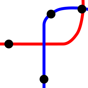
It might be faster for riders to transfer between the southern and western leg if there were a station at the exact physical intersection point, but as long as the next station on the red line has a transfer to the blue line it counts, even if the blue line has one (or more) stations in the middle. Washington supplies an example of this non-miss: it frustrates riders that there’s no connection between Farragut West and Farragut North, but at the next station south from the intersection on the Red Line, Metro Center, there is a transfer to the Blue and Orange Lines. London supplies another pair of examples: the Northern line and the Waterloo and City line appear to intersect the District line without a transfer, but their next station north from the physical intersection point, Bank, has an in-system transfer to Monument on the District.
There are still a few judgment calls in this system. One is what to do at the end of the line. In this case, I rule it a missed connection if the terminal clearly has an intersection without a transfer; if the terminal is roughly between the two stations on the through-line, it doesn’t count. Another is what to do about two lines that intersect twice in close succession, such as the Bakerloo and Hammersmith and City lines in London, and Metro Lines 4 and 10 in Paris. In such cases, I rule that, if there’s just one station on the wrong side (Paddington on Bakerloo, Mabillon on M10) then I rule it a single intersection and allow transfers at the next station over, by which standard London has a missed connection (Edgware Road has no Bakerloo/H&C transfer) and Paris doesn’t (Odeon has an M4/M10 transfer).
How many missed connections are there?
In Paris, there are three missed connections on the Metro there is one missed connection on the Metro (update: see comments below): M9/M12, M5/M14, M9/M14. As I discuss on City Metric, it’s no coincidence that two of these misses involve this miss involves Line 14, which has wide stop spacing. Narrow stop spacing makes it easier to connect within line-dense city centers, and Paris famously has the densest stop spacing of any major metro system. M9/M12 and M9/M14 morally should connect at Saint-Augustin and Saint-Lazare, but in fact there is no in-system transfer. M5/M14 should connect at Gare de Lyon, but when M5 was built it was not possible to get the line to the station underground and then have it cross the Seine above-ground, so instead it meets M1 at Bastille, while M14 doesn’t serve since it expresses from Gare de Lyon to Chatelet. A fourth missed connection is under construction: the extension of M14 to the north misses M2 at Rome, prioritizing long stop spacing over the connection to the M2/M6 circumferential.
In Tokyo, there are many misses. I am not sure why this is, but judging by line layout, Tokyo Metro and Toei try to stick to major roads whenever possible, to avoid tunneling under private property, and this constrains the ability of newer lines to hit station locations on older lines. If I understand this map correctly, there are 19 missed connections: Ginza/Hibiya (Toranomon and Kasumigaseki should connect), Ginza/Mita, Ginza/Yurakucho, Ginza/Shinjuku, Marunouchi/Mita (Ginza and Hibiya should connect), Marunouchi/Yurakucho, Asakusa/Yurakucho, Asakusa/Hanzomon, Hibiya/Namboku, Hibiya/Yurakucho (Tsukiji and Shintomicho should connect), Hibiya/Hanzomon, Hibiya/Shinjuku, Hibiya/Oedo, Tozai/Oedo, Tozai/Fukutoshin, Mita/Oedo, Chiyoda/Oedo twice, and Oedo/Fukutoshin. Oedo is particularly notable for being a circumferential line that misses a large number of transfers.
In New York, there are even more misses. Here the culprit is clear: the two older layers of the subway, the IRT and BMT, have just two missed connections. One, 3/L at Junius Street and Livonia Avenue, is an outlying miss. The other is central: Bowling Green on the 4-5 and Whitehall on the R-W should connect. But the newer layer, the IND, was built to drive the IRT and BMT into bankruptcy through competition rather than to complement them, and has a brutal number of misses: ABCD/2-3, ACE/1-2-3, AC-F/2-3-4-5, AC-G/2-3-4-5-BQ-DNR, BD/NQRW, BDFM/NQRW, BD/JZ, E/1, E/F, M/NW, R/7, F/BD-NQ, F/NRW, F-Q/4-5-6, F/NW, G/7, G/JMZ. Counting individual track pairs, this is 46 misses, for a total of 48 including the two IRT/BMT misses; I’m excluding local-only transfers, such as Columbus Circle and 53rd/Lex, and counting the 42nd Street Shuttle as an express version of the 7, so it doesn’t miss the BDFM transfer.
Finally, London only has eight misses. In Central London there are three: the Metropolitan or Hammersmith and City line misses the Bakerloo line as discussed above, and also the Victoria line and Charing Cross branch of the Northern line at Euston. The other five are outlying: the Central line misses the Hammersmith and City line at Wood Lane/White City, and its branches miss the Piccadilly line’s Uxbridge branch three times; the fifth miss is Metropolitan/Bakerloo. But one more miss is under construction: the Battersea extension of the Northern line is going to intersect the Victoria line without a transfer.
The difference between the two kinds of miss
Many misses are located just a few stations away from a transfer. In New York, some misses are just a station away from a transfer, including the G/7 miss in Long Island City, the E/1 miss between 50th Street and 59th Street, and several more are a few stations away, such as the various BDFM/NQRW misses. In London, these include two of the three Central London transfers: there is an H&C/Bakerloo transfer at Baker Street and an H&C-Met/Victoria transfer at King’s Cross-St. Pancras. As a result, not counting the Waterloo and City line, only two trunk lines in the system do not have any transfer: the Charing Cross branch of the Northern line and the Metropolitan/H&C line.
On a radial network, if two lines don’t have any transfer, then the network is degraded, since passengers can’t easily connect. In New York, this is a huge problem: some station pairs even within the inner networks require two transfers, or even three counting a cross-platform local/express transfer. My interest in subway networks and how they function came about when I lived in Morningside Heights on the 1 and tried socializing with bloggers in Williamsburg near the JMZ.
In Paris the three misses are also a problem. Line 4 is the only with a transfer to every other main line. Line 9 intersects every other line, and Line 14 will when its northern extension opens, but both miss connections, requiring some passengers to take three-seat rides, in a city infamous for its labyrinthine transfer stations. Fundamentally, the problem is that the Paris Metro is less radial than it should be: some lines are laid out as grid routes, including Lines 3, 5, and 10; moreover, Lines 8, 9, 12, and 13 are radial but oriented toward a different center from Lines 1, 4, 7, and 11.
In London, in contrast, there is almost no pair of stations that require a three-seat ride. The Charing Cross branch of the Northern line doesn’t make any stop that passengers from the H&C or Met line can’t get to from another line with one interchange (Goodge Street is walking distance to Warren Street). A bigger problem is the lack of interchange to the Central line on the west, which makes the connections between the H&C stations on the west and some Central line stations awkward, but it’s still only a small number of stations on each line. So the problem in London is not network robustness.
Rather, the problem in London is severe capacity limitations on some lines. Without good outlying interchanges, passengers who want to get between two lines need to ride all the way to the center. Most likely, passengers between the Piccadilly and Central line branches to the west end up driving, as car ownership in West London is relatively high. Passengers without a car have to instead overload the Central line trunk.
The same problem applies to misses that are strictly speaking not missed connections because the two lines do not actually intersect. In Paris, this occurs on Line 7, which swings by the Opera but doesn’t go far enough west to meet Lines 12 and 13. In London, the best example is Hammersmith station: the H&C and District lines have separate stations without an interchange, but they do not intersect since it’s the terminus of the H&C line and therefore I don’t count it as a miss. But morally it’s an outlying miss, preventing District line riders from changing to the H&C line to reach key destinations like Euston, King’s Cross, and Moorgate without overloading the Victoria or Northern line.
In New York this problem is much less acute. The only outlying misses are the 3/L and the ABCD/2-3; the 3/L connects two very low-ridership tails, so the only serious miss is on the Upper West Side. There, passengers originating in Harlem can walk to either line, since the two trunks are two long blocks apart, and passengers originating in Washington Heights can transfer from the A-C to the 1 at 168th Street; at the other end, passengers bound for Midtown can transfer at Columbus Circle, using the underfull 1 rather than the overcrowded 2 and 3.
The role of circumferential lines
Outlying transfers are useful in distributing passengers better to avoid capacity crunches, but they are incidental. They occur when formerly competing suburban lines get shoehorned into the same subway network, or when two straight roads intersect, as in Queens. But the task of distributing passengers between radial lines remains important and requires good connections between as many pairs of radials as possible.
The usual solution to this is a circumferential line. In Moscow, there are several missed connections in the center (Lines 3/6, 3/7, 6/9) and one more planned (8/9), but the Circle Line helps tie in nearly all the radii together, with just one missed connection (to Line 10 to the north) and one more under construction (to Line 8 to the west). The point of the Circle Line is to allow riders to connect between two outlying legs without congesting the center. This is especially important in the context of Moscow, where there are only a handful of interchange stations in the center, most of which connect more than two lines.
In London, the Overground is supposed to play this role. However, the connections between the Underground and Overground are weak. From Highbury and Islington clockwise, the Overground misses connections to the Central line, the Victoria line, the main line of the District line, the Piccadilly line, the Hammersmith and City line, both branches of the Northern line, and the Piccadilly line (it also misses the Metropolitan line, but that’s on a four-track stretch where it is express and local service is provided by the Jubilee line, with which there is a transfer). Much of this is an unforced error, since the Underground lines are often above-ground this far out, and stations could be moved to be better located for transfers.
In New York, the only circumferential line is the G train, which has uniquely bad transfers, legacy of the IND’s unwillingness to build a system working together with the older subways. Triboro RX (in the original version, not the more recent version) would play this role better: with very little tunneling, it could connect to every subway line going counterclockwise from the R in Bay Ridge to the B-D and 4 at Yankee Stadium. On the way, it would connect to some major intermediate centers, including Brooklyn College and Jackson Heights, but the point is not just to connect to these destinations in the circumferential direction but also to facilitate transfers between different lines.
Going forward, cities with large metro network should aim to construct transfers where feasible. In New York there are perennial proposals to connect the 3 and L trains; these should be implemented. In London, the missed outlying transfers involve above-ground stations, which can be moved. The most important miss, White City/Wood Lane, is already indicated as an interchange on the map, but does not to my understanding have an in-system transfer; this should be fixed.
Moreover, it is especially important to have transfers from the radial lines to the circumferential ones. These improve network connectivity by allowing passengers to change direction (from radial to circumferential, e.g. from east-west to north-south within Queens), but also help passengers avoid congested city centers like outlying radial-radial transfers. Where circumferential lines don’t exist, they should be constructed, including Triboro in New York and Line 15 in Paris; where they do, it’s important to ensure they don’t miss connections the way the Overground does.
The MTA Genius Challenge is as Bad as Expected
A year ago, Governor Andrew Cuomo declared a competitive $2.5 million grant, to be disbursed by what he dubbed the Genius Challenge. I wrote about it at the time, expressing skepticism that it would lead to anything useful. The panel of eight judges had only one person with background in the transportation industry, a former FRA administrator. The word “genius” itself is a tech mainstay that to me mostly means “I don’t know any Fields Medalists.” And the topics within the scope of the grant seemed more about what the tech industry thought were the most pressing issues and not what the lowest-hanging actually were. I had very low expectations, and the announcement of the winning entries met them.
The grant has three topics: signaling, rolling stock (interpreted broadly), and underground mobile or wireless service. The last three is by far the least important; it also got only half a million dollars, whereas each of the other two got a full million. Each of the two main ideas shows how weak the very concept of the genius grant is, but they do so in dramatically different ways.
The rolling stock winners included a vendor asking for a grant for New York to use its rolling stock (CRRC); the problems with that idea are more akin to those of the signaling section, so I will cover them there. A second rolling stock winner was a proposal to use better data collection to facilitate preventive maintenance; this idea may or may not work, it’s hard to tell from layers of obfuscating business language. It’s the third idea that deserves the most attention, and the most scorn: lengthening trains but not platforms.
The crank Idea: lengthening trains
The genius competition gave a $330,000 grant for the idea of lengthening trains from 10 to 14 cars without lengthening the platforms. Trains would alternate between only berthing the first 10 cars and only berthing the last 10. Transit Twitter has already dumped on this idea, and for good reason: the proposal reads like a crank paper purporting to prove the Riemann hypothesis or another famous result, starting with a lot of trivial observations and then making a leap of logic buried somewhere in the middle.
The basic problem with running trains that are longer than the platforms is that passengers need to be able to move to the correct car, which takes time. The report says that this is done on the London Underground, which is true, but only at outlying stations – as is the case on the subway in New York. The conductor announcement “only the first five cars will open” is familiar to anyone riding the 3 train and was familiar to anyone riding the 1 train before the new South Ferry station opened. This is fine as long as the station in question is low-volume enough that the extra dwell time does not interfere with operations. Lengthening trains beyond the platforms at busier stations than Harlem-148th Street 145th Street or South Ferry would result in a shuffle forcing passengers to scramble within the train (if moving between cars is possible) or on the platform (if it isn’t). The dwell times would be brutal and would almost certainly reduce capacity measured in passengers per hour.
The proposal handwaves this critical flaw by saying that dwell times would decrease because crowding would decrease. This assumes that dwell times are a function exclusively of on-train crowding, rather than of the number of passengers getting on or off the train. The same number of passengers would have the same platform space, but would actually only be able to use a fraction of it: many would only be able to use the 6 cars that go to their chosen destination, and at those cars, the volume of passengers per unit of platform length would rise.
The second handwave is unlimited stations, with longer platforms. Acknowledging that the busiest stations should have all doors open, the proposal says,
[P. 20] Third, 18.5% of rides occur through just 10 stations in Manhattan. In the medium term, the platforms can, and should, be extended at these 10 stations to enable customers that embark and disembark at them to use any car at both ends of their trip. Accordingly, 9.25% of the customers that presently need to use the middle cars could instead use the end cars.
This is the equivalent of the logical leap from trivial to wrong in a crank paper. First, the number of central stations that would need to be lengthened is much more than 10, including some key origins (86th/Lex, Jamaica Center, etc.) and transfer points (West 4th, Canal, 96th/Broadway). And second and more importantly, the busiest stations are multilevel complexes, where just adding more pedestrian circulation is hard; London is spending a considerable amount of money on that at Bank. Lengthening platforms at these stations is prohibitively expensive. This problem is discussed in cities with constrained underground platforms in the CBD, such as Vancouver, where nearly all Expo Line stations are above-ground (thus, relatively easy to lengthen), but the most crowded in Downtown Vancouver are in a tunnel, where platform reconstruction costs too much to be economic.
The bigger question is why the judges did not catch the error. The proposal brings up London as an example, which serves to bring the magic of the foreign to people who are unfamiliar with best industry practices. Saying that New York does the same is equally true, and in a way more relevant to the proposal (since New York doesn’t let people move between cars, making this more challenging than in London), but would raise questions like “can the dwell times of relatively light stations like South Ferry or Harlem-145th be replicated at the top 40 stations?”. London is Anglophone and some reformist New Yorkers have used it as a source of foreign ideas the way they wouldn’t use non-Anglophone cities. But the judges didn’t do the basic due diligence of checking whether London really implements the idea as widely as the proposal implies, and if not, then why not.
The rent-seeking idea: CBTC by another name
New York State awarded four applicants $250,000 each for ideas about signaling. All four ideas boiled down to the same thing: introducing new technology for communication between trains permitting the functional equivalent of moving-block signaling, at a lower cost than preexisting communication-based train control (CBTC) installations.
The grantees all have experience in the transportation industry. Rail signaling vendors Thales and Ansaldo propose to use cameras to read automated signals; train sensor provider Metrom Rail and veteran rail manager and consultant Robert James propose ultra-wide broadband to improve train location precision. There’s nothing obviously wrong about their proposals. Nor is there anything outlandish, which is why each of the two technologies has two independent applicants behind it. Thales and Ansaldo in particular have experience in advanced signaling – Thales supplied CBTC to the L 7 train in New York and to Metro Line 13 in Paris, and Ansaldo supplied rail automation to Copenhagen and CBTC to a number of Paris Metro lines.
Even then, questions about cost remain. Robert James’ and Metrom’s proposals leave a bad taste in my mouth for their cost estimates. James has a systemwide cost estimate somewhat less than $200 million, not much more than $500,000 per km; Metrom says its system costs “$3 million per mile” and compares itself positively with legacy CBTC systems at $20 million per mile. Actual costs of CBTC without automation in Paris on Line 13 were about 5 million euros per km according to Wikipedia, and this includes modification of the railyards and not just the signaling system. So the Metrom system’s claimed figure is still cheaper, but not by quite as much. Metrom also complains that in Boston, CBTC would not improve capacity much because it would prohibit double-berthing, an issue that is only relevant to a subway-surface system and not to a full metro.
The broader problem with this part of the grant is that if the MTA put out an RFP about CBTC on the subway, it would get bids from Ansaldo, Thales, and Metrom, and James might well bid or consult for a bidder. It would be able to judge the technical merit of each proposal in much closer detail than given in the competition. Instead, the state is paying vendors to market their technology to the public, which would influence future procurement.
While the grant asks about whether the technology is proprietary, it makes no attempt at establishing a multi-vendor standards. Such standards exist: Thales and Ansaldo are both listed as ERTMS vendors. In France there’s already a discussion in the trade press about whether using ERTMS is better than using CBTC; the discussion specifically mentions New York’s uniqueness as a network with connected rather than isolated lines, and says CBTC is designed for isolated lines whereas ERTMS is designed for shared lines, such as the RER system. European experts might well recommend that New York use ERTMS for the subway, even though it’s a system originally designed for mainline rail.
New York’s highly-branched system means it must be more conservative with new technology – there’s nowhere to test it, now that the L and 7 already have CBTC. The shuttles might be useful test cases, or the 1 and 6 trains on weekdays, but without isolated lines, the cost of a mistake in procurement or technological failure is much higher. This suggests the MTA should try to reduce the complexity of branching (which is what I would’ve proposed if it had been within the grant’s scope), and until then concentrate on imitating proven technology rather than innovating. This is especially important given the potential for rent-seeking, in which the vendors use the grant to market themselves to the state over competitors selling similar product.
The judges don’t know any better
Would a panel of judges with more familiarity with metro operations around the first world have come to better decisions? Probably. Through blogs, railfan forums, and comments, I know people with great knowledge of existing operations in a number of cities in the first world, and for the most part they think highly enough of their local systems that they’d ask of any innovation, “why hasn’t it been implemented here already?”.
I wrote in 2011 that people in the US who make technical arguments in favor of public transit tend to be skeptical of many proposals, to the point of finding existing US agencies incompetent. This is US-specific: London Reconnections is a technical blog but it tends to support Transport for London’s process, Swiss and Japanese railfans seem to trust their local rail operators, and even Transport Paris is more positive about STIF’s capital investment than New York-based blogs are about the MTA’s. Experts (and not just bloggers like me) could point out innovations their cities have that can be imported into New York, as well as shoot down bad ideas for which “why doesn’t London/Paris/Tokyo do it?” is a useful sanity check.
Note that sometimes there is a legitimate reason to do something that nobody else has tried. New York’s highly branched network makes ERTMS a better deal there than on other metro systems, and an RFI would be prudent. But because the details of implementation matter more than the idea of innovative genius, it has to go through the regular procurement process.
Cuomo attempted to inject the inventions of the American tech industry into the subway. Instead, he created space for cranks to promulgate their ideas and for vendors to have a leg up over their competitors in any future bid. In effect, his attempt to improve the economic productivity of the public sector to be more in line with that of the American tech industry is going to make the public sector less productive, through weaker institutions (namely, a less robust CBTC bid) and distraction (namely, the useless train lengthening idea).
Transit and Scale Variance Part 3: Grids
This is my third post about scale variance in transit planning; see parts 1 and 2. In part 1, I discussed how good bus networks exist at a certain scale, which can’t easily be replicated at larger scale (where the slowness of city buses makes them less useful). In part 2, I went over a subway planning feature, especially common in the communist bloc, that again works only at a specific scale, namely cities with enough population for 3-4 subway lines; it gets more complex in larger cities, and cannot be imported to bus networks with 3-4 lines. In this post, I will focus on one scale-variant feature of surface transit: the grid.
The grid works only for surface transit and not for rapid transit, and only at a specific scale, so constrained as to never be maximally useful in an entire city, only in a section of a city. This contrasts with what Jarrett Walker claims about grids. Per Jarrett, grids are the perfect form of a transit network and are for the most part scale-invariant (except in very small networks). One of the impetuses for this post is to push back against this: grids are the most useful at the scale of part of a transit city.
Grid Networks Versus Radial Networks
I’ve written a few posts exhorting subway planners to build their networks in a certain way, which, in the most perfect form, is radial. In particular, tangential subway lines, such as the G train in New York (especially when it ran to Forest Hills), Line 10 in Paris, and Lines 3 and 6 in Shanghai, are weak. When the G train was running to Forest Hills, most local passengers would switch from it to the next Manhattan-bound train, leading New York City Transit to send more Manhattan-bound local subways to Forest Hills and eventually to cut back the G to Long Island City. Based on these examples, I contend that on a subway network, every line should be either radial, serving the CBD, or circumferential, going around the CBD.
My post about New York light rail proposes a network with some lines that are neither: in the Bronx, my proposal is essentially a grid, with north-south routes (Grand Concourse, Webster, 3rd) and east-west ones (161st, Tremont, Fordham) and one that combines both (145th-Southern). Regular commenter NewtonMARunner criticized me for this on Twitter. I answered that the lines in my proposal are based on the busiest buses in the Bronx, but this simply shifts the locus of the question to the existing network: if transit lines should be radial or circumferential, then why are the tangential Bx19 bus (145th-Southern) or the Bx40/42 and Bx36 (Tremont, with a long radial eastern tail) so successful?
To answer this requires thinking more carefully about the role of circumferential routes, which by definition don’t serve the most intensely-used nodes. In Paris, Lines 2 and 6 form a ring that misses five out of six train stations and passes just outside the CBD, and yet they are both busy lines, ranking fourth and fifth in ridership per km. The reason is that they are useful for connecting to radial Metro lines and to some RER lines (namely, the RER A and the southern half of the RER B). Tangential lines miss connections much more easily: in the west, Line 10 here has a decent transfer to Line 9 and a somewhat decent one to Line 8, but to Lines 12 and 13 it’s already not very direct. The G train in New York has the same problem to the south – few connections to lines that actually do go into Manhattan.
Consider the following three possible networks:


The radial network is a typical subway network. The full grid lets you go from everywhere to everywhere with just one transfer, at the cost of having far more route length than the radial network. The partial grid no longer lets you go from everywhere to everywhere easily, and has the outer two lines in each service direction missing city center, but still has more overall route-length than the radial network. The principle here is that a grid plan is useful only if the grid can be complete.
The scale, then, is that rapid transit is so expensive that there’s no money for a complete grid, making a radial plan more appropriate. But surface transit, especially by bus, can be spread across a grid more readily. The Bronx’s size, density, and bus ridership patterns are such that a mostly complete grid is feasible within the western two-thirds of the borough, supplemented by the subway. In this environment, a tangential route is fine because it hits all the radial routes it could, and could provide useful two-seat rides to a large variety of destinations.
Are Grids Really Grids?
Chicago has a relentless bus grid. The three busiest north-south routes are the tangential 8 (Halsted), 9 (Ashland), and 49 (Western), which are 22, 29, and 26 km long respectively. None enters the Loop; Halsted, the easternmost, is at the closest approach 800 meters from the Loop, across a freeway. The two busiest east-west routes, the 77 (Belmont) and 79 (79th), are also far from the Loop.
However, I contend that these routes don’t really form a grid, at least not in the sense that passengers ride between two arbitrary points in Chicago by riding a north-south bus and connecting to an east-west bus. Instead, their outer ends form tails, which people ride to the L, while their inner ends are standard circumferentials, linking two L branches. The L in turn is purely radial and doesn’t follow the Chicago grid, with the Blue Line’s O’Hare Branch, the Orange Line, and the Brown Line all running diagonally.
Vancouver is similar. The north-south routes are radial, veering to enter Downtown. The east-west ones are more circumferential than tangential: they connect the Expo and Canada Lines, and most also connect to UBC. The Broadway buses (9 and 99) pass so close to Downtown Vancouver they’re more tangential, but they also offer the shortest path between the Expo and Canada Lines (making them a strong circumferential) while at the same time serving high job density on Central Broadway (giving them some characteristics of a radial).
In the absence of a radial rail network to connect to, long grid routes are less useful. Cities have a center and a periphery, and the center will always get more ridership, especially transit ridership. The outermost grid routes are often so weak that they should be pruned, but then they weaken the lines they connect to, making it necessary to prune even more lines until the grid is broken.
The Optimal Scale for a Grid
A strong transit grid will not form in a city too small for it. There needs to be a large enough center with enough demand for transit ridership to justify more than a purely radial bus network with a timed transfer. At the same time, the city cannot be too big, or else the arterial buses are too slow to be useful for ordinary work and leisure trips, as in Los Angeles.
What’s more, there is no Goldilocks zone, just right for a grid. Chicago is already too big for a bus grid without the radial rail layer. It’s also too big for what Jarrett calls grid accelerators – that is, rapid transit routes that replace bus grid lines: the Red Line is plausibly a grid accelerator, but the other lines in Chicago are not, and if there were L lines only at grid points, then the Red Line and the one east-west route would get overcrowded heading toward the Loop. Even Vancouver, a compact metro area hemmed by mountains and the ocean, relies on the diagonal Expo Line to serve Downtown and doesn’t really have a grid beyond city limits. A less dense city in the same land area could have a grid, but without much traffic or a strong CBD, cars would always beat transit on time and only the poor would ride the bus.
The scale in which grid networks work more or less on their own seems to be that of Vancouver proper, or that of the Bronx. Vancouver is 115 km^2 and the Bronx is 110 km^2; Vancouver’s bus grid spills over to Metrotown and the Bronx’s to Upper Manhattan, but in both cases these are small increases in the relevant land area.
Tellingly, Vancouver still relies on the bus network to feed SkyTrain; the Canada Line is a grid accelerator, but the Expo Line is not. The Bronx is the more interesting case, because it is not a city or even the center of the city, but rather a dense outlying portion of the city with an internal arterial grid. In both cases, the grid is supplementary to the radial rail core, even if the routes that use it have a lot of independent utility (Metro Vancouver has higher bus ridership than rail ridership, and the Bronx buses combined have slightly more ridership than the combined number of boardings on the Bronx subway stations).
Geographical constraints matter as well. The Bronx and Upper Manhattan are hemmed by water and by the administrative border of the city (which also includes a sharp density gradient), and Vancouver is hemmed by water and by a density gradient in the east. This makes it easier to equip both with grids that are close enough to the complete grid in the middle image above rather than the incomplete one in the third image. The Bronx’s lower-density eastern tails happen to meet up with those of Queens, forming circumferential routes, and also have enough north-south subway lines to feed that they remain useful.
In a transit city, the grid cannot come first. Even if there is a street grid, the spine of the network has to be radial as soon as there is demand for more than two rapid transit lines. The role of surface transit remains feeding rapid transit. Grids look attractive, but the optimal scale for them is awkward: large-scale surface transit grids are too slow, forcing the city to have a rapid transit backbone, and if the city is too small for that then the arterial grid provides too good auto access for public transit to be useful.

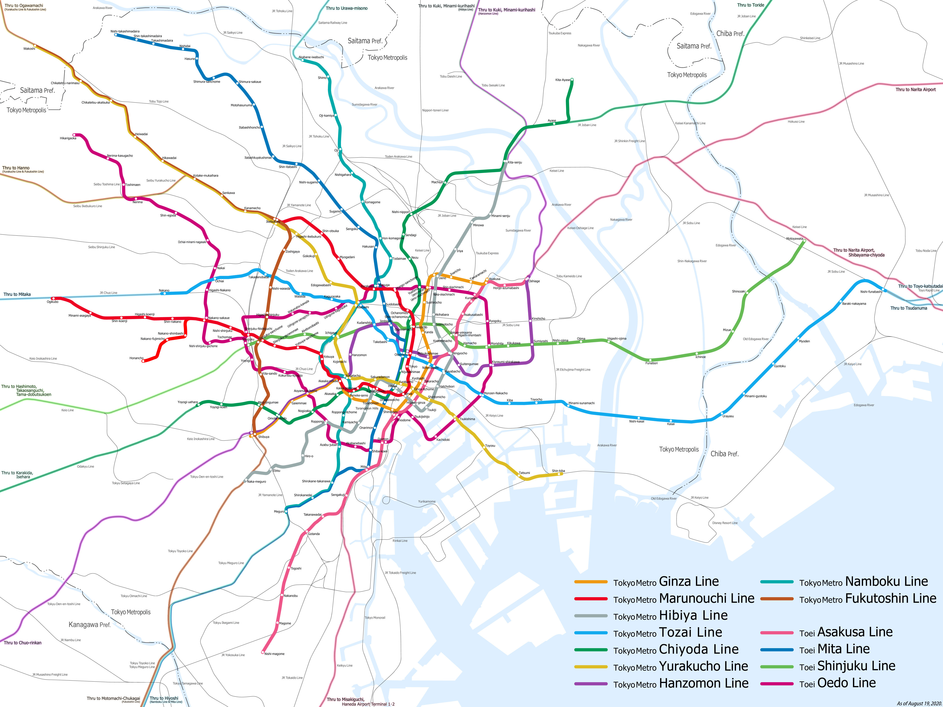