Providence Should Use In-Motion Charging for Buses
The future of bus transit is in-motion charging. This technology, increasingly common in Central Europe, is a hybrid of the trolleybus and the battery-electric bus (BEB), offering significant off-wire range with no need for centralized recharge facilities. Moreover, the range of batteries is improving over time and so is the recharge rate; in the limit, a pure BEB system may work, but in the present and near future it is not yet reliable in cold weather and requires diesel or oil heaters when the temperature is below freezing.
My original post on IMC technology speaks largely of New York and Boston, but Providence is an excellent place for implementing this technology as well, at least as good as Boston and far better than New York. As Rhode Island is thinking of how to invest in urban transit, it should take this technology into consideration, in addition to proposals for light rail along its busiest route (the Rapid, formerly the 99 and 11 buses) or a diesel BRT.
Transit Forward RI 2040
The guiding program, adopted in 2020, is called Transit Forward, and aims for a statewide plan including regional connections as well as the core of a solid mass transit network in Providence. The Rapid route is to be turned to light rail, perhaps, and multiple other core routes are to be upgraded to BRT standards (including the Rapid if light rail is rejected). This can be viewed here or here. Here is the metropolitan bus map:
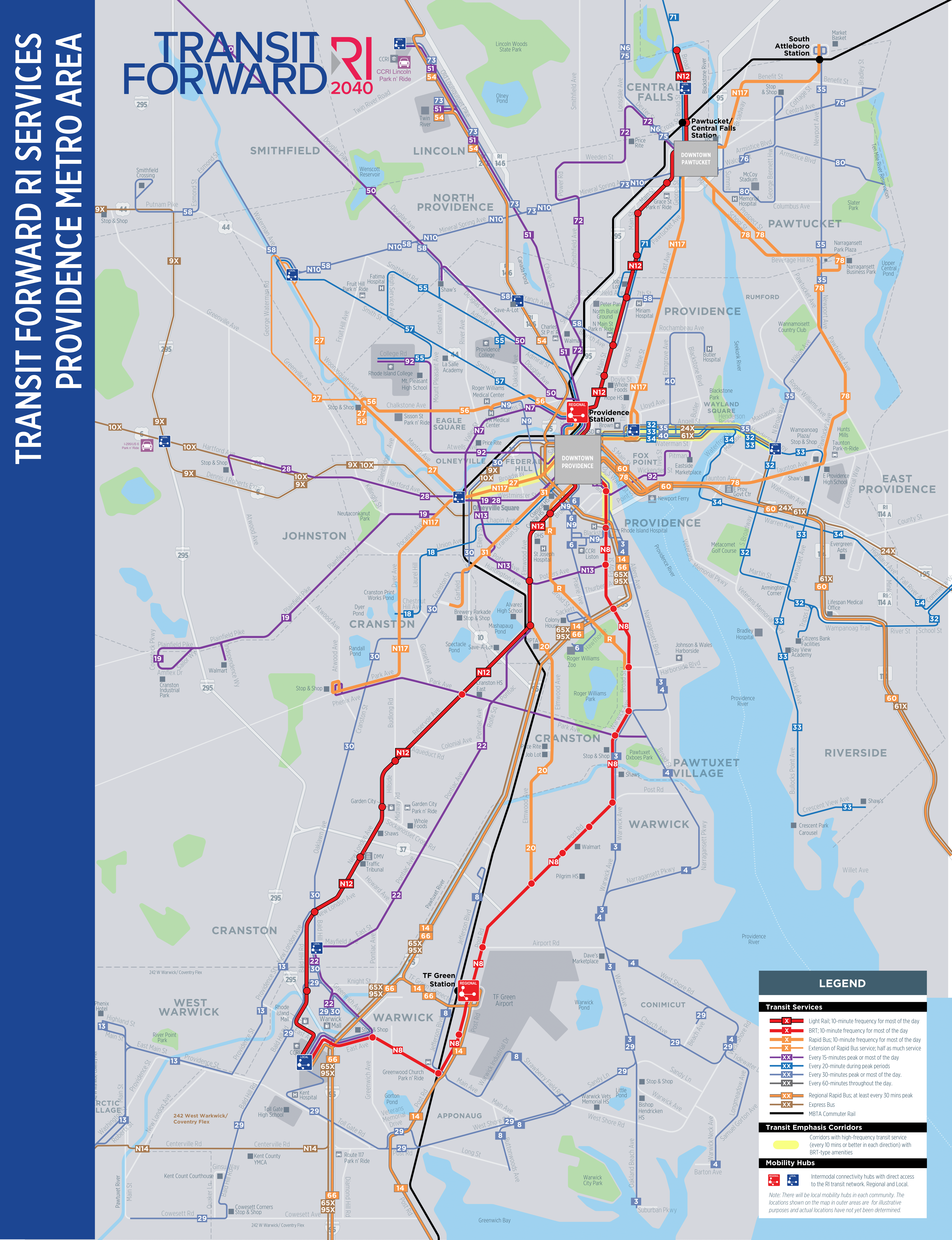
Observe that multiple trunks are designed to have very high all-day frequency. Already today, service on Broadway and Westminster from Downcity to Olneyville interlines to a bus every 7.5 minutes; the proposal is to boost this to a bus every 7.5 minutes on Westminster and also one every 5 on Broadway. Past Olneyville, the buses branch at lower frequency. South Main is to have a core trunk route every 10 minutes and also a less frequent regional bus. The Angell/Waterman one-way pair is to have three routes running every 20 minutes, two every 30, and two less frequent express buses; closer in, this one-way pair shares the bus tunnel between Downcity and College Hill with routes running on Hope, labeled N117 in the plan.
On net, this is a massive expansion of bus frequency available to people in and around Providence. Were it available when I lived there, I would have an easier time traveling to Pawtucket, East Providence, and other such locations, often for gaming purposes; with the network as it is (or as it was in 2012), I would walk 6 km from my home in Fox Point to a gaming store in Pawtucket and it would still be faster than waiting 40 minutes for the bus in the evening.
IMC and branching
IMC as a technology permits buses to run about 10 km off-wire; the current frontier of the technology is that a minimum of 20-30% of the route needs to be wired. UITP presents it as an advantage in that the wiring cost is only 20-30% of that of a traditional trolleybus, but in fact the wiring cost is much lower, because the trunks can be wired while the branches are left unwired.
This advantage is hard to realize in a city like Chicago or Toronto, with a relentlessly gridded bus network and little branching. Both cities rely on rapid transit for downtown access, and have a bus grid layered on top of their radial metro systems to provide everywhere-to-everywhere connectivity and feed the trains. In such an environment, IMC saves 70-80% of the cost of a trolleybus, minus the additional cost of procuring a bus with a backup battery. This may sound like a lot, but trolleybus expansion is rare globally, so reducing the cost by a factor of 4 does not necessarily turn it into an attractive investment.
But in Providence, there is no grid. About 4 km of wire in each direction, from Downcity to past Henderson Bridge, are enough to electrify nearly the entire bus network connecting the city with East Providence. Another 3 km along South Main and I-195 complete electrification to the east. The N117 may need a short stub on Thayer in addition to the bus tunnel; Broadway and Westminster, totally around 6 km, should be enough to electrify buses to and beyond Olneyville; the core of Broad is planned to carry the N12 and R, both at high frequency, and is therefore a prime target for wiring as well; Charles should be enough to wire most of the buses going due north or northwest.
This way, a core trolleybus network with maybe 30 km of wire in each direction can electrify most of the bus network in Providence, without having to deal with the teething problems of BEBs.
The issue of legibility
One minor benefit of wire in Providence is that it helps casual riders make sense of the public transportation network. A big disadvantage of bus networks over rail is their poor legibility: the map has too many routes and a user is expected to know them all over an area, and there is no indication on the street as to where the buses go. Marked bus lanes help solve the latter problem, as does wire.
Trolleybuses are not streetcars. Their ride quality is that of a bus – usually better, occasionally worse, depending on who I ask. Their network structure is usually like the core of an urban bus network, and not like that of a modern light rail network, which a casual user can get at a glance. The presence of wire makes the system easier to see on the ground, helping improve legibility.
This is especially important in cities without grid networks – precisely the environments in which on purely technical issues IMC is already strongest. In Vancouver, the buses are largely gridded, and so it is generally clear where they go: they run on major streets like Broadway, King Edward, 41st, Arbutus, and MacDonald. But in Providence, it’s not always clear, especially in the seams between two networks. Broadway has a few choices of street connections toward Kennedy Plaza – do buses go on Sabin? Or Fountain? Or Empire to Washington? Westminster has no clear connection – do buses turn left or right on Franklin/Dave Gavitt Way? Wire helps make it clear for the confused passenger who doesn’t live in town, or who lives on the East Side and isn’t familiar with the Federal Hill street network.
This can be better than light rail
RIPTA is interested in making its highest-intensity route, now the R and in the future the N12, into a light rail line. I get where it’s coming from, but I have some worries. Providence development is frustratingly almost linear, but not quite; the train station is in a street loop off Main, and on the map above, the N12 veers off the straight path to connect to it. I don’t know what the optimal way is of serving such a destination, and it’s likely the answer will change over time based on changes in the technology and in other connections.
IMC can be good precisely for this. If the route is partly wired, then small deviations based on changes in the plan are viable, albeit at the cost of legibility. The same goes for uncertainty over which routes connect to which: the R today interlines the old 99 on North Main to Pawtucket and the old 11 on Broad to South Providence, but the plan is to instead connect South Providence to Downcity via the Jewelry District using the N8, and instead have the N12 primary route continue southwest to Warwick via Elmwood and Reservoir. Such changes require a commitment to mode: swaps are fine as long as both routes use the same mode – if they’re both light rail then it is viable and the same is true if they’re both buses, but not if one is rail and the other is bus. IMC downgrades both to a bus, but in a way that permits higher ride quality to some extent and lower emissions at very low costs.
