There’s a rite of passage every year in Berlin of taking a day trip to Bielefeld, an hour and a half away by ICE, every 10 minutes. The idea is to be able to retort to aging millennials who joke that Bielefeld does not exist than they’ve actually been there.
The Abitur is coming soon, and 12th-grade students are supposed to study, but Adam Mansour, Katja Brühl, Max Kleinert, and Nora Martinek are going in Bielefeld. It is not the best day to travel. Friday is a school day, even if it’s short enough it ended at 13:30, and it’s also a popular travel day so the tickets were a bit more expensive, and Adam had to convince his parents it’s worth spending 80€ and all the Germans do it. But at least today it means they don’t have to wake up at 7:00 tomorrow.
On the train going west, Katja keeps complaining about how the train bypasses Magdeburg because of 1980s-90s politics. She says she was looking for labor-related museums in Bielefeld but couldn’t find any; instead, she talks about how the mayor of Hanover is leading a red-black coalition and it’s not the SPD that she’s voting for in September or the SPD that subsidized childcare in Berlin that let her parents afford to have children.
The other three don’t find her annoying. Max and Nora come from much wealthier families, and Nora’s is scratching 10,000€/month, but when Katja talks about how thanks to education reforms pushed on the Länder by the Green-led federal government she could go to the same school as them, they don’t feel either attacked or guilty. They feel happy that they know her and Adam. They listen to what she says about Jusos and housing, the EU, feminism, or comprehensive schools, and it clicks with them because it’s their world too. They know that there are people who resent that the cities are growing faster and associate immigration with social problems; but they associate immigration with Adam’s parents, or with Nora, who only moved to Germany when she was five but who nobody ever calls an immigrant. Adam, in turn, does get called a Syrian immigrant, even though he was born in Germany, his parents having arrived just before the 2015 wave.
There are some American tourists on the train, talking about how pretty Germany is and how they wished the United States could have such a system. Max leans forward and says, “every time they’re on a train, they talk just about the train,” figuring circumlocutions because the Americans might recognize the German word Amerikaner and realize he is talking about them. Nora and Katja giggle, and Adam then joins too.
Otherwise, they try to distract themselves by talking about the exams and about university plans. All plan to go, and all have been told by teachers that they should get good enough grades to go where they want, but Max wants to study medicine and needs to get a 1.0 to get past the numerus clausus. “Do you want me to test you?” Adam asks him.
“Lol.”
They are all competitive about grades, even Katja, who told them once that neoliberal models of academic competition promoted inequality, and the Greens should do more to prevent what she calls the Americanization of German education. But Max told them when they planned the trip last week that he was treating it as his vacation day when he wouldn’t need to think about school.
—
Getting off the train, they start walking toward city hall; Bielefeld doesn’t have a bikeshare system, unlike Berlin, and bringing a bike on the ICE is not allowed. Adam insists on stopping on the way and taking detours to photograph buildings; most aren’t architecturally notable, but they’re different from how Berlin looks.
They run to the Natural History Museum and the Kunsthalle. The museum closes at 17:00 and they have less than an hour, then less an hour at the Kunsthalle until it closes at 18:00. They furiously photograph exhibits when they don’t have enough time to look at them and talk about them.
Adam is especially frantic at the archeology section, just because of the reminder of what he is giving up. He has read a lot of popular history and for the longest time wanted to go study it, but felt like he wouldn’t be able to get work with a humanistic degree and instead went for the real stream at school. When he met Katja two years ago he felt like this choice was confirmed – Katja for all her political interests is going to study environmental engineering and at no point expressed doubt about it.
Max spits on the Richard Kaselowsky memorial when the staff isn’t looking, distracted by other customers. In Berlin he might not even do this, but in Bielefeld he wouldn’t mind getting thrown out of a museum if worst came to worst. Nora and Adam didn’t know the history so as they go in he tells them Kaselowsky was a Nazi and so was the museum’s founder Rudolf Oetker, and the Oetker heirs had to return a few items that may have been stolen from Jewish owners in the Holocaust.
—
They find a döner place with good reviews and good falafel for Katja and are eating there. Normally they’d go out and get different things in Berlin, but Bielefeld is still a small city and even with Germany’s rapid immigration in the 2020s it doesn’t have Berlin’s majority-migration-background demographics.
Where they’re sitting overlooks the pedestrianized streets of the old city. There are some bikes, some pedestrians, some walking delivery drones. Berlin has a few of these zones within the Ring but they’re not contiguous and Bild accuses the Greens of promoting car-free zones for everyone except the federal government.
They talk about where they want to go, but Max and Katja are hesitant to publicly say what they feel about where they are. It’s Nora who openly says that she’s having fun and that Bielefeld definitely exists no matter what her parents say, but she wouldn’t want to live here. She doesn’t know if she wants to stay in Berlin – she wants to go to TU Munich, partly to see more places, partly because of some parental pressure to leave home – but Bielefeld feels a little too dörferlich.
They all laugh, and Adam says that judging by how his parents describe Daraa, it was a lot smaller than this. He says that they didn’t ever describe Daraa as especially lively, and always compared it negatively with Berlin when he was young and then eventually they just stopped talking about it, it stopped being important to them. Max and Katja nod and start comparing Bielefeld to parts of Germany they know well through extended family – Max’s father is from Münster and his mother’s family is in Göttingen and Hamburg, Katja’s parents are both from Berlin but her mother has family in Fürstenwalde.
And then somehow it drifts back to the election. Katja is worried the Union might win the election this time, stop free work migration, and freeze the carbon taxes at present levels. Adam doesn’t have family left in Syria but they have a few classmates who have family in India, in Vietnam, in Turkey. For the most part things are okay, but there’s always the occasional teacher or group of students who still think Neukölln and Gesundbrunnen are bad neighborhoods; they know who to avoid because people who are racist always find something negative to say to Adam specifically.
—
But for now, they have one another, and they have exams to score highly on to move on and go to university, and they have two hours to kill in Bielefeld until the ICE train they booked in advance departs to take them back home.
Queens needs a bus redesign, thankfully already in the works; it also needs better LIRR service that city residents can use as if it’s an express subway. A key part of bus redesign is having buses and trains work together, so that buses feed trains where possible rather than competing with them. The proposed Queens redesign incorporates subway transfers but not LIRR transfers since the LIRR is infrequent and charges premium fares. This raises the question – how does the optimal bus network for Queens change in the presence of better city service on the LIRR? And conversely, how can the LIRR be designed to be of better use to Queens bus riders?
It turns out that the answer to both questions is “very little.” The best Queens bus network in a city where the LIRR lines through Queens run every 5-10 minutes all day is largely the same as the best network in a city where the LIRR remains an exclusive suburb-to-Manhattan mode. Similarly, bus connections change little when it comes to infill stations on the LIRR for better city service. This is not a general fact of bus redesigns and regional rail – the reason for this pattern has to do with the importance of Flushing and Jamaica. Nor does it mean that regional rail is irrelevant to buses in Queens – it just means that the benefits of rerouting buses to serve additional LIRR stations are too small compared with the drawbacks.
Flushing and Jamaica
This is the present-day subway infrastructure:
This is a deinterlined map, but the infrastructure in Queens is the same
The 7 train terminates in Flushing; the E (drawn in F-orange above) and J/Z terminate in Jamaica, while the F terminates in Jamaica as well slightly farther east. As a result, the proposed Queens redesign has many buses from farther east diverting to one of these two neighborhood centers in order to connect with the subway better.
The LIRR changes the rail network situation. The Port Washington Branch, probably the easiest to turn into frequent S-Bahn service, parallels the 7 but continues past Flushing into the suburbs, with closely-spaced stations in the city from Flushing east. The Main Line likewise runs parallel to the Queens Boulevard Line and then continues east past Jamaica with additional stations in Eastern Queens, with branches for the Montauk Line and the Atlantic Line (Far Rockaway and Long Beach Branches).
The ideal bus grid is isotropic. An extension of train service in the radial direction makes it easier to run a bus grid, because buses could just go north-south on major streets: Main, Kissena-Parsons, 149th, 162nd-164th, Utopia, 188th, Francis Lewis, Bell-Springfield. In contrast, the planned redesign diverts the 164th route to Jamaica to connect to the subway, and treats 149th as a pure Flushing feeder. Moreover, the east-west buses in Northeast Queens all divert to serve Flushing.
However, in practice, all of these kinks are necessary regardless of what happens to the LIRR. Queens destinations are not isotropic. Flushing and Jamaica are both important business districts. Jamaica also has transit connections that can’t be provided at an existing or infill LIRR Main Line station, namely the JFK AirTrain and the multi-line LIRR transfer.
Southeast Queens
I can think of one broad exception to the rule that the optimal bus redesign for Queens is insensitive to what happens to the LIRR: the radial lines going from Jamaica to the southeast. These include the Merrick Boulevard routes, today the Q4, Q5, and N4, or QT18 and QT40-42 in the redesign; and the Guy Brewer Boulevard routes, today the Q111 and Q113-4 and in the redesign the QT13, QT19, QT43, and QT45. As of 2019, each of the two avenues carries slightly fewer than 20,000 riders per weekday.
Those buses are likely to lose traffic if LIRR service on the Montauk and Atlantic Lines improves. Long-range traffic is far faster by train; I expect people to walk long distances to an LIRR station, a kilometer or even more, for a direct, subway-fare trip to Manhattan coming every 10 minutes. Even lines that require people to change at Jamaica should wipe out most bus ridership, since the transfer at Jamaica is designed to be pleasant (cross-platform, usually timed).
In their stead, buses should run orthogonally to the train. Linden should get a single bus route, which in the redesign proposal is the QT7, losing the Linden-Jamaica QT40 in the process and instead running the QT7 more frequently. Farmers, running north-south crossing the Main, Montauk, and Atlantic Lines, should get higher frequency, on what is today the Q3 and in the redesign the QT68; in both cases it diverts to Jamaica rather than continuing north to Bayside and Whitestone, but as explained above, this is a necessary consequence of the job concentration in Jamaica.
LIRR infill
Integrated design of buses and trains means not just moving the buses to serve the trains, but also choosing train station locations for the best bus transfers. One example of this is in the Bronx: Penn Station Access plans should include one more infill station, built at Pelham Parkway to connect to the Bx12. By the same token, we can ask how bus-rail connections impact LIRR planning.
The answer is that, just as they only lightly impact bus route design, they do not impact LIRR station siting. Ideally, LIRR stations should be sited at major streets in order to connect with buses better. However, this is to a large extent already the case, and places where moving a station or building infill is valuable are sporadic:
On the Port Washington Branch, there is no station at Francis Lewis. It may be valuable to build one, or alternatively to close Auburndale and replace it with two stations, one right at Francis Lewis and one at Utopia.
On the Main Line, Queens Village is already at Springfield, Hollis is already at 188th/Farmers, and an infill station at Merrick is valuable regardless of what happens with the buses. A Francis Lewis station is plausible, but is so close to both Hollis and Queens Village that I don’t think it’s necessarily a good idea.
The Montauk Line is not penetrated by many crossing arterials. Linden already has a station, St. Albans. Then to the south there is an awkward succession of three intersections within 850 meters: Farmers, Merrick, Springfield. The least bad option is probably to build an infill stop in the middle at Merrick, with the shopping center as an anchor, and with ramps leading to Farmers and Springfield.
The Atlantic Line has the Locus Manor stop at Farmers, and Rosedale at Francis Lewis. Laurelton may be moved a bit west to hit Springfield better, and in addition, 1-2 infill stations are valuable, one at Linden and possibly also one at Baisley. But the Linden infill, like the Merrick infill, is fully justified regardless of bus transfers
Conclusion
In Queens, the importance of Flushing and Jamaica works to permit mostly separate planning of bus and regional rail service, except to some extent in Southeast Queens. This is not true in most other places, especially not elsewhere in New York. It follows from the fact that without city-usable LIRR service, buses have to divert to Flushing and Jamaica to feed the subway, whereas with city-usable LIRR service, buses still have to divert to Flushing and Jamaica because they are important business and cultural centers.
This is useful, because transit is a complex system, so anytime it’s possible to break it into mostly independently-planned components, it gets more tractable. If the bus redesign doesn’t require dealing with Long Island NIMBYs and traditional railroaders, and if turning the LIRR into a useful S-Bahn doesn’t require simultaneously redrawing the Queens bus map, then both processes become easier. A redesigned Queens bus map already comes pre-optimized for future LIRR improvements with mostly cosmetic changes, and this is good for the process of transit modernization.
The Pacific Northwest seems like the perfect region for high-speed rail: its cities form a neat line from Vancouver to Portland and points south, grow at high rates with transit-oriented development, and have sizable employment cores around the train station. And yet, when I generated my high-speed rail maps, I could only include it as a marginal case, and even that inclusion was charitable:
Red means lines that should definitely get high-speed rail, blue means marginal cases, some with strong medium-speed tie-ins.
There’s been a lot of criticism over why I’m including Atlanta-Jacksonville but not Vancouver-Seattle-Portland, and I’d like to explain why the model says this.
Density
The population density in the Western United States is very low. What this means in practice is that cities are far apart – the best example is Denver, a large metropolitan area that is 537 km from the nearest million-plus metro area (Albuquerque). A high-speed line can connect two cities, maybe three, but will not form the multi-city trunk that one sees in Germany or Italy, or even Spain or France. Lines can still make sense if they serve enormous cities like Los Angeles, but otherwise there just isn’t much.
This relates to Metcalfe’s law of network effects. In a dense region, the 500-800 km radius around a city will have so many other cities that network effects are obtained as the system grows. Even Florida, which isn’t dense by European standards, has cities placed closely enough that a medium-size system can connect Miami, Orlando, Tampa, and Jacksonville, and then with a 500 km extension reach Atlanta. The I-85 corridor can likewise accrete cities along the way between Washington and Atlanta and get decent ridership.
In the Pacific Northwest, any intercity infrastructure has to live off Vancouver, Seattle, and Portland – that’s it. Spokane is small, orthogonal to the main line, and separated by mountains; Salem and Eugene are small and Salem is technically in the Portland combined statistical area; California’s cities are very far away and separated by mountains that would take a base tunnel to cross at speed. And Seattle is just not that big – the CSA has 5 million people, about the same as Berlin, which has within 530 km every German metropolitan area.
The model
The model thinks that with Vancouver (2.6)-Seattle (5) at 220 km and Seattle-Portland (3.2) at 280, ridership is as follows, in millions of passengers per year in both directions combined:
City S\City N
Vancouver
Seattle
Seattle
2.33
—
Portland
1.63
2.76
In operating profits in millions of dollars per year, this is,
City S\City N
Vancouver
Seattle
Seattle
33.32
—
Portland
52.98
50.23
This is $135 million a year. It’s actually more optimistic than the official WSDOT study, which thinks the line can’t make an operating profit at all, due to an error in converting between miles and kilometers. The WSDOT study also thinks the cost of the system is $24-42 billion, which is very high. Nonetheless, a normal cost for Vancouver-Portland HSR is on the order of $15 billion, a bit higher than the norm because of the need for some tunnels and some constrained urban construction through I-5 in Seattle.
It isn’t even close. The financial ROI is 0.9%, which is below the rate of return for government debt in the very long run. Even with social benefits included, the rate is very low, maybe 2.5% – and once social benefits come into play, the value of capital rises because competing government investment priorities have social benefits too so it’s best to use the private-sector cost of capital, which is 4-5%.
This exercise showcases the value of density to intercity rail networks. You don’t need Dutch density, but Western US density is too low – the network effects are too weak except in and around California. It would be mad to build Atlanta-Jacksonville as a high-speed rail segment on its own, but once the Florida network and the I-85 network preexist, justified by their internal ridership and by the Piedmont’s connections to the Northeast, connecting Atlanta and Jacksonville becomes valuable.
Growth
The one saving grace of the Pacific Northwest is growth. That’s why it’s even included on the map. Lines in the 1.5-1.8% ROI region are not depicted at all, namely Houston-New Orleans and Dallas-Oklahoma City-Kansas City-St. Louis, both discounted because none of the cities connected has local public transportation or a strong city center. The Pacific Northwest is not discounted, and also benefits from strong growth at all ends.
The gravity model says that ridership is proportional to the 0.8th power of the population of each city connected. To get from 0.9% to 2% requires a factor of 2.2 growth, which requires each city to grow by a factor of 2.2^0.625 = 1.65.
Is such growth plausible? Yes, in the long run. In 2006-16, Metro Vancouver grew 16%; in 2010-9, the core three-county Seattle metro area (not CSA) grew 16% as well, and the core Portland metro area (again, not CSA) grew 12%. At 16% growth per decade, the populations will rise by the required factor in 34 years, so building for the 20-year horizon and then relying on ridership growth in the 2050s and 60s isn’t bad. But then that has a lot of risk embedded in it – the growth of Seattle is focused on two companies in a similar industry, and that of Vancouver is to a large extent the same industry too.
Moreover, the region’s relative YIMBYism can turn into NIMBYism fast. Metro Vancouver’s housing growth is healthy, but the region is fast running out of developable non-residential areas closer in than Surrey, which means it will need to replace single-family housing on the West Side with apartment buildings, which it hasn’t done so far. Growing construction costs are also threatening the ability of both Vancouver and Seattle to feed commuters into their central business districts by rail – Seattle may have built U-Link for costs that exist in Germany, but the Ballard/West Seattle line is $650 million/km and mostly above-ground, and the Broadway subway in Vancouver, while only C$500 million/km, is still on the expensive side by non-Anglo standards. It’s useful to plan around future growth and safeguard the line, but not to build it just on the promise of future growth, not at this stage.
The discussion of regional rail in New York usually focuses on through-running, with neat S-Bahn-/RER–stylemaps showing how lines run. But it’s also instructive to look at longer-range lines, under the rubric of RegionalBahn in Germany or Transilien in Paris. I’ve argued against segregating long- and short-range commuter trains in New York, on the grounds that its infrastructure layout is different from that of Berlin or Paris.
However, it is still necessary to conceptually plan longer-range regional rail in the New York region – that is, how to serve destinations that are too far to be really considered suburbs. I think that those lines should through-run, which makes the planning somewhat different from a standard intercity integrated timed transfer network, but the choice of where to go to, what frequency to push for, and so on is still important. This post should be seen as a pre-map version of what I drew for Upstate New York and New England, but for the Tri-State Region and satellites in Pennsylvania. It should also be seen as a companion to any high-speed railproposal, albeit unmapped because I am still uncertain about some visible aspects.
Scope
The scope of this post is anywhere one should be able to get to from New York without resorting to high-speed rail. This covers the combined statistical area and its penumbra. In practice, this post will focus on areas that are off the Northeast Corridor than on areas that are on it. On the Northeast Corridor, I’ve talked about low-speed solutions toward New Haven putting it slightly more than an hour away from New York; instead of repeating myself, it’s better to discuss other destinations.
So what are the satellite regions around New York, excluding the city’s own suburbs? Let’s make a list:
Eastern Long Island far enough to be outside the commute zone, like the Hamptons
The Jersey Shore, likewise focusing on what’s too far for commuting, like Toms River
Trenton
Allentown and the Lehigh Valley
The Delaware Water Gap Region and possibly Scranton
The Mid-Hudson Valley on both sides of the river, i.e. Newburgh and Poughkeepsie
Historic city centers in Connecticut: Danbury, Waterbury, Bridgeport, New Haven
For the most part, they already have commuter rail service. But travel demand is usually not very commuter-oriented. Some of those lines have service that accommodates this fact, like express LIRR service to the Hamptons at popular weekend getaway times. Others don’t. Newburgh, Allentown, Toms River and Delaware Water Gap have no service at all, though Delaware Water Gap is on the under-construction Lackawanna Cutoff.
The need for electrification
All trains touching New York must be fully electric. This means spending not a lot of money on completing wiring the LIRR, Metro-North, and New Jersey Transit, and ensuring further extensions are electrified as well. Diesel trains are slow and unreliable: the LIRR’s mean distance between failures is around 20,000-30,000 km on the diesel and dual-mode locomotives and well into the 6 figures on the EMUs. New Jersey Transit’s diesels also tend to only serve Hoboken, which forces an additional transfer; NJT’s new dual-mode locomotives are extremely costly and low-performance.
This kind of completionism is especially valuable because of fleet uniformity. Boston is reticent about electrification because it likes having a fleet it can maintain all at one place, and it requires some additional resources to expand a railyard that can accommodate future electrification. In New York this works in reverse: a large majority of the network is electrified, and getting rid of the diesel tails increases efficiency through scale.
The issue of express service
All of the tails in question are far from New York, generally 100 or more km, and close to 200 km for Montauk. This introduces tension between the need to run intense local service to areas 15 km from Manhattan and the need to maintain adequate speed at longer range. The solution is always to prioritize shorter-range service and make regional rail the most express pattern that can fit within the through-running paradigm. This works well where there are four tracks allowing long-range express service, as on the Northeast Corridor and the Empire Corridor, including tie-ins like Danbury and Waterbury.
Elsewhere, this is compromised. EMUs can still beat present-day diesel trip times, but the average speeds of the 30-30-30 plan for Connecticut are not realistic. This is a tradeoff; it is possible to run express trains to the Hamptons on the Babylon Branch, but it imposes a real cost on frequency to dense suburbs and should therefore be avoided. If there’s room for timed overtakes then they are welcome, but if there’s not, then these regional trains should really run as S-Bahn trains that just keep going farther out.
This has precedent on busy lines. Trains in the exurbs of Tokyo tend to run at the same speed as an ordinary rapid train, for example on the Chuo Line; there is the occasional higher-speed liner, but usually the trains to Otsuki, Takasaki, Odawara, etc. are just ordinary rapids, averaging maybe 50 km/h. In New York the average speed would be higher because there are still fewer stops even with the infill I’m proposing, which fits since there is more sprawl in New York.
Onward connections
Some of the outer ends in question should also get service that doesn’t go to New York. There is an existing line between Danbury and Brewster that can be used for revenue moves. Allentown lies on a decent SEPTA Regional Rail extension, albeit not on a good one, as the route is curvy. If there are internal bus systems, for example in Waterbury, then whenever possible they should pulse with the train, and it goes without saying trains that do not serve New York should be timed with trains that do.
This for the most part should run on a half-hourly clockface schedule. This means that on an S-Bahn network where even individual branches run every 10-15 minutes, there should be a rule saying every train in 2 or 3, depending on base frequency, continues onward to a distant destination. This is a combination of Northern European planning (timed connections) and Japanese planning (treating long-range regional rail in a megacity as a commuter train that goes further than normal).
So, first of all, thanks to Queaugie for making this, it’s much cleaner than my drawings on an OpenStreetMap base; I keep advocating for geographically accurate maps, but schematics do sometimes have their uses. But more to the point, I’d like to give some context to why some lines are and are not included.
Some examples of past maps
Mapped proposals for American high-speed rail go back a while. On the Internet, interest exploded in the 2000s, leading to high hopes for California High-Speed Rail and the Obama stimulus. Yonah Freemark made one at the beginning of 2009, which played a role in his rise to become a superstar public transit wonk. The RPA had its own plan rooted in the concept of megaregions: see here for analysis from 2011 and here for a synthetic map. But the map that’s getting the most airplay is by Alfred Twu, which is very expansive to the point of having two transcontinental connections; it was most recently covered in Vox and tweeted by Secretary of Transportation Pete Buttigieg, which generated so much discussion that I chose to crayon US high-speed rail rather than my original intention of picking a city and crayoning urban rail for it.
How my proposal differs
My map differs from past ones in visible ways – for one, it is not connected. At the time I started to make it, I believed there would be four components: Florida, Texas, California, and the general Eastern network. It turned out late in the process that there’s decent demand for Atlanta-Florida travel, enough to justify connecting Florida to the general network. But Texas and California remain disconnected, as does the marginal case of the Pacific Northwest.
Analytically, I project traffic by a gravity model, depending on the product of two metro areas’ populations; Yonah and the RPA have different methodologies. But the emergent difference is, first of all, that I have a less connected network, and second, that there are some glaring omissions. I believe those omissions are justified and would like to explain why – in effect, why other people overrate connections that I do not include.
Amtrak and stagnating regions
New Orleans was the largest city in the South until overtaken by Houston around 1950. This means that the historic rail network of the United States served it amply, as it was large relative to turn-of-the-century America. Amtrak, formed to preserve a skeleton of the preexisting passenger rail network, retained the importance of New Orleans and gave it three distinct long-distance routes: one to Atlanta and New York, one to Chicago, one on the way between Florida and California. This way, there is more Amtrak service to New Orleans today than to Houston, whose metro area is around five times larger.
Proposals tend to build upon what exists. So most people recognize that at transcontinental scale, high-speed rail is uncompetitive, but at the scale of Atlanta-Birmingham-New Orleans it looks like a reasonable line. It should get decent modal split, if built. The problem is that not many people live in New Orleans today. The population one needs to sustain high-speed rail is large, larger than that of your typical early-20th century city. This can be done either via a megacity that drives ridership, as in France or California, or via high population density so that many midsize cities are close together, as in Germany or Florida; the best geography is when both are present, as in Japan, South Korea, China, and the Northeastern US.
The growth of the South in the last 70 years has not been even. Texas has exploded, and so have Atlanta, Nashville, and the cities of the North Carolina Piedmont. In contrast, New Orleans is stagnant. Farther north, on the margins of the South, Missouri has had about the same population growth since 1920 as New York, and has been steadily losing seats in Congress. St. Louis and Kansas City, like New Orleans, were huge hubs for early-20th century America, but their populations are just not good enough for high-speed rail. Chicago-St. Louis can squeak by, but Kansas City is too far. Memphis is in relative decline as well, but manages to piggyback on Nashville, albeit marginally.
People are sharing various maps of the high-speed rail network the US could build if it were interested in alternative transportation, and I promised I’d make one myself. I did this on camera on Twitch a week ago but was not finished, so I streamed it again just now – this is going to be a regular occurrence, always at 18:00 my time every Saturday. There’s a recording, but Twitch is being weird about letting me upload it, so it might make it to YouTube instead.
Here is the map:
A full-size image can be found here. Red lines are high-speed rail. Blue lines are marginal lines: New Haven-Springfield and Milwaukee-Green Bay are good legacy lines that may or may not work as full HSR (the former probably better than the latter), while Nashville-Memphis, the Pacific Northwest system, and Phoenix-Tucson are marginal between no service at all and HSR.
Florida High-Speed Rail
I did the calculations for Atlanta-Florida on camera. I was surprised that it turned out to work out well, even with semi-decent return on investment based on my Metcalfe’s lawformulas, around 3%. The rub is that Orlando is pretty big, and even though it is sprawl hell, it is also an unusually strong tourist destination, and the rail line would serve Disney World and Daytona Beach. This makes me more confident in a formula trained on Japanese and European cities with public transit than a connection between two random no-transit medium size cities like Cleveland and Cincinnati.
This itself is an example of Metcalfe’s law in action: the Miami-Orlando-Tampa system by itself only returns 2.2% per the formula, and an extension to Jacksonville 2.6%. I also have more certainty in the figures for the larger system, because the impact of sprawl on mode choice is smaller when distances get longer, because it doesn’t affect the air/rail mode choice as much as the car/rail mode choice.
Even at medium distances, observe that the South Florida urban area is linear, around 20 km wide but more than 100 long, which makes intercity rail service more reasonable. Every county can have a stop, and if the 0.8 exponent in the gravity model formula is applied to counties separately, then the sum rises to 6.1, whereas 7^0.8 = 4.74, which means that this refinement provides a 28% boost to ridership. Orlando is not linear, but its subsidiary metro areas, Lakeside and Daytona Beach, could get stops as well.
Alignment questions
I drew the system in a zoom level 7 on OpenStreetMap, which is too high-altitude to see individual railroads. I tried to approximate existing rail alignments that are worth using, but it’s not perfect, so please do not take the map as any assertion about pixel-level alignment, and even some station decisions can be quibbled with.
However, please do take the map as a definitive assertion about macro-scale alignments. The Northeast Corridor should go via I-95 and not via Hartford. This decision is fairly close and could go either way, though the benefits of HSR in the Northeast are so great that the absolute magnitude of such decisions remains momentous. Elsewhere, the Chicago-Minneapolis line could go along I-94 via Eau Claire or via a more southerly route via Rochester and the Mayo Clinic; I’ve gone back and forth on this, and it’s a second-order question, but I think the Mayo Clinic generates more trips, probably. The Albany-Montreal route could be entirely in the state of New York or take a slight detour through easier terrain in Vermont, which is likely cheaper. Toronto-Ottawa could go via Kingston or Peterborough, but the Peterborough route looks more direct. Chicago-St. Louis is sometimes proposed to detour via Champaign rather than go straight via Bloomington, but the benefit of serving UIUC probably doesn’t justify the extra cost. North Carolina HSR could go via the Triad or direct from Raleigh to Charlotte, but the model says the benefit of serving Greensboro is much greater than that of slightly faster trips coming from bypassing the Triad. Texas is a compromise route extending the under-construction line to Downtown Houston and creating a new leg connecting this system to Austin and San Antonio.
The most contentious questions are in California. HSR there should go via a partially high-speed coastal alignment from San Diego up to Los Angeles, then up the Grapevine and Tejon Pass, then across Altamont Pass and a Dumbarton tunnel. None of these decisions is close, and the official alignment decisions to detour via the Inland Empire and Palmdale and to go via Pacheco are all bad and played a role in the failure of the project. Los Angeles-San Diego is in a way the most frustrating: it was left to a future phase, but a medium-speed rail alignment along the coast could be done relatively quickly with electrification and some strategic investments, speeding up trains to about 1:45.
Frequency
I talked about frequency a little bit in the video, but not in much detail. The biggest problem is that Philadelphia is set up poorly: ideally trains coming from New York should branch to either Washington or Pittsburgh, but instead, 30th Street Station requires New York-Pittsburgh trains to reverse direction. This can be handled through actual reversal, as is done today at Frankfurt, with 4-minute turnarounds (cf. 10 at Philadelphia), or through having New York-Pittsburgh trains skip Philadelphia, as was historically done, with a stop at North Philadelphia instead.
With that in mind, my best guess, based partly on the model and partly on intra-metropolitan fudge factors like New York-New Haven, is as follows:
8 tph New York-Boston, 4 New York-Springfield
8 tph New York-Washington, 4 New York-Pittsburgh-Cleveland, 4 Washington-Philadelphia-Pittsburgh-Cleveland
8 tph New York-Albany, 4 short Boston-Albany, 8 Albany-Buffalo (4 short), 4 Buffalo-Toronto, 4 Albany-Montreal, 2 short Buffalo-Cleveland
The main difference is that public transportation does not have competition the way private industry does. In many travel markets, for example rush hour travel to city center, it is a monopoly. In others, it isn’t, but it remains fundamentally different from the competition, whereas private-sector marketing generally involves competition between fairly similar products, such as different brands of cars or computers or supermarkets. This also means that trying to turn public transit into a competition between similar providers is overrated: it is bad from the perspective of good planning, but it turns the industry into something private-sector marketers are more familiar with, and is therefore at risk of being adopted (for example, with EU competition mandates) despite being counterproductive.
Brand identity
Companies that make products that are very similar to their competition engage in extensive marketing. Coke vs. Pepsi is the most cliché example, but different brands of cookies, fast food, cars, computers, and smartphones do the same. The differences between these brands are never zero: I can generally tell different brands of bottled water by taste, Samsung- and Sony-made Androids have some differences (let alone iPhones), and so on. But it’s not large either.
Objectively, the cost of switching firms is small, so marketers first of all spend enormous amounts of money on advertising, and second of all aim to create identity markers to impose an emotional cost on customers who switch: “I am a Mac.” If the small differences involve differences in price point, then this can include a marker of class identity; even if they don’t, there’s no shortage of ways to tell people what brand of alcohol or food or video game best fits their microidentity. Establishing brand identity also involves loyalty programs, like airline miles and hotel points: why compete when you can lock passengers into your airline alliance?
This can even bleed into product development to some extent. Microsoft’s embrace, extend, exterminate strategy was designed around getting people to switch to Microsoft products from competitors. This was not a marketing gimmick – the people who developed Excel made sure everything that Lotus 1-2-3 users were used to would also feature in Excel in order to reduce the cost of switching to Microsoft, before using Windows’ power to lock people into Office.
Mass transit is not like this
Public transportation competes with cars as a system. It has a monopoly in certain travel markets, namely rush hour travel to city center, but the existence of those markets itself comes from real estate competition, in which it is necessary to entice companies to choose to locate in city center rather than in a suburban office park. Of note, the following features, all unusual for private-sector competition, apply:
Competition is for the most part binary: public transportation versus cars. (Bikes complement transit.)
The public transit side of the competition has economies of scale because of the importance of frequency of arrival, and thus is harmed by any internal competition, whereas the car industry has different automakers and works just fine that way.
The service has very little customization – everyone rides the same trains. Attempts to introduce product differentiation are harmful because of the frequency effect.
The product is completely different from the competition – useful at different times of day, in different neighborhoods, for different destinations. Switching incurs costs of similar magnitude to those of migration.
Much of the competition is not for customers, but for development – city center development is good for public transit, sprawl is good for cars.
There is competition over public resources, which cannot be divorced from the mode even in an environment of privatization – someone still has to build roads and finance subways.
The consequences of mass transit Fordism
Public transportation is and remains a Fordist product – no product differentiation, highly regimented worker timetables, one-size-fits-all construction, vertical integration. The vertical integration aspects go even farther than early-20th century industry, covering infrastructure, timetables, the equipment, and development. User choice is extensive regarding where to go within the system – I have access to far more variety of products as a consumer and jobs as a worker in Berlin (and had even more in Paris) than I would have driving in a sprawl environment, but I can’t choose what brand of train to use.
This is particularly important when preferences are heterogeneous. Different users have different walking speeds, transfer penalties, idiosyncrasies about access to wifi on board, etc. Planning has to use averages, and for the most part this works without too many seams, but it means that the standard way private businesses use product differentiation doesn’t work.
Of note, this Fordism also exists for the road network, if not for the cars themselves. It’s just far less visible. Drivers may have different preferences that translate to different costs and benefits for a cloverleaf versus a four-level interchange, but engineers can’t have two sets of interchanges, they just build one based on criteria of traffic density. However, the experience of driving on the interchange is not visible as part of the system to the drivers, who occasionally grumble about traffic at a particular intersection but don’t see it as clearly as transit riders see specific transfer stations or modal questions like streetcar vs. subway.
How private-sector marketing can harm transit
Because mass transit is a single system for everyone, standard private-sector marketing schemes involve changes to service that harm the overall system.
Creating brand identification with a specific subgroup of users, such as when some private buses market themselves to tech workers with wifi and USB chargers and charge higher fares, and still can’t make money. Public transportation has to work on an any vehicle, any place, any time principle. Only a handful of hyper-frequent routes can take multiple brands without losing passengers due to the lower frequency of each brand, but on those routes the only reliable way to timetable service is to run on headway management in which case any vehicle can substitute for any vehicle, which means you can’t brand.
This is especially bad when the brands are different modes: bus, bike, streetcar, subway, commuter train. When some modes are marketed to the rich and others are to the poor, capacity is wasted and frequency within each class is lower. Moreover, infrastructure planning is weaker with such differentiation, because often a region or subclass will be close to the wrong mode, forcing expensive additional construction. The United States fails by running commuter rail just for the rich while subways are for the rest, while India fails by doing the exact opposite; both countries build unnecessary infrastructure and underinvest in intermodal integration as a result.
Finally, because public transportation is a complex system, trading the need for inter-organization and interdepartmental organization for much lower overall provision costs, people who come into it from consumer product markets may miss some of the required connections. This is especially true of development – people who sell consumer products, including cars, don’t need to think how urban design has to look for their product to succeed. Even people who have heard of transit-oriented development may get it wrong; in the United States, it is common to build some apartment buildings next to a train station but neglect retail and local services, and YIMBY as a movement is at best indifferent to city center office towers.
I’m going to stream on Twitch at 18:00 tonight my time (UTC+1). This is usually intended as a platform for streaming playing video games, but can also be used for other things, such as discussions that would benefit from video and screen sharing. This may turn into a regular feature, covering a different topic every time – probably monthly, I don’t see myself having enough time to do this weekly unless it’s extremely impromptu.
Today’s topic is crayons:
How I make maps such as these ones: how I grab the base map, how I draw lines, etc.
Good tips for how to figure out which lines are useful, including very rudimentary cost-per-rider analyses.
An example of making a map, probably a US-wide high-speed rail map based on my Metcalfe’slaw posts but maybe something else if there’s popular demand.
I had an idea that the reaction to my last post would go along the lines it did. It was incredibly nitpicky, sometimes pointing out valid concerns, but often just asserting certain things are impossible or incompatible with Long Island culture that happen thousands of times a day in large European and Japanese cities. And it speaks to different communities in different cities – as I said in the post, I wrote that article in the style of a TransitMatters Regional Rail appendix, like the just-released Newburyport/Rockport Line appendix. This matters, in a number of different ways. The most important is this:
The complexity of regional rail
Naively, Boston should be a harder system to modernize than New York. The system is not electrified, and only around half the stations don’t even have high platforms. Most lines have single-track bottlenecks, especially the world-of-pain Old Colony system. Then there’s the need to tie everything together with the North-South Rail Link, to be built as a four-track rail tunnel underneath the Big Dig.
And yet, it’s still easy mode. Boston has four commuter lines on each side: Fitchburg, Lowell, Haverhill, Eastern; Worcester, Providence, Fairmount, Old Colony. There are some alignment questions in that the Franklin Line can get to Boston via the Providence Line (that is, the Northeast Corridor) or the Fairmount Line and that the outer Haverhill Line can be turned into a branch off Lowell, but otherwise the eight lines are independent. The North Station approach has a six-track pinch point, but a schedule that is optimized for short turnarounds is a schedule that automatically avoids at-grade conflicts in the throat. So each system can be planned independently; the line-by-line appendix structure comes from this technical fact.
Moreover, on the level of ridership and social planning, the lines’ sheds are mostly disjoint too. It makes complete sense to speak of jobs on the Providence Line: Providence, for one, has 30,000 jobs within 1 km of the station, which is a near-tie with Ruggles for #4 in the system after the two Boston terminals and Back Bay; and there is never much of an overlap between different lines’ sheds. This also leads to some socioeconomic targeting – the Eastern Lines appendix linked at the top of this post goes into the economic justice implication of service to working-class suburbs on the line, like Chelsea and Lynn.
New York is not like this, at all. The lines are too dense: the Hempstead Line is closely parallel to the Main Line, and it matters that Garden City and Mineola’s walk sheds overlap, albeit only marginally. The branching structure is such that one must treat each system as a whole from the start, with only a handful of plausible cleaves. My Hempstead Line post winks at that by briefly talking about how to schedule Babylon trains, but the reality is that the technical complexity of timetabling New York-area commuter railroads is genuinely high, especially once through-running comes in. (Our Boston Regional Rail timetables are pre-NSRL, so without through-running.)
None of this should be taken to mean that this is not possible. Nor does this mean it is only possible with the sort of expenditures the MTA and Port Authority are used to. Surface improvements should be budgeted in the billions of dollars, but that is equally true of Boston, with New York’s greater size trading off against the mostly-electrified, mostly-high-platform character of its network. The real difference is that Boston can do this in $1-2 billion chunks and each chunk has meaningful improvements on a few lines, whereas in New York there are more moving parts and planning has to be more integrated.
In a way, this shouldn’t surprise. Big cities trade off greater efficiency for greater needs of social organization. New York’s efficiency means that most of it can have every bus and train run every six minutes, but then someone has to plan these bus networks and train connections. At metro area scale, it has enormous potential transit ridership – I think Metro New York beats every other American metro region for how much extra transit ridership it can get in absolute numbers through better capital construction and operations, even Los Angeles – but this doesn’t easily lend itself to line-by-line planning.
Line by line in New York
New York plausibly has the weakest directionality of any city I’m familiar with. Its directional identities are New Jersey vs. in-state suburbs, and to some extent North vs. South Shore of Long Island but city vs. suburbs is the dominant distinction, so social targeting on one commuter line is completely pointless.
This also has an implication for infrastructure. The Hempstead Line is also really two different things – the Hempstead Line proper and the local tracks within the city, with different needs. The East Garden City branch is a way to fit them together, using the jobs around East Garden City to really look for ways to create more local service within Eastern and Central Queens. The upshot is that in New York, a large fraction of the missing ridership on regional rail – the difference between the region’s 800,000 daily riders and Ile-de-France’s 3.5 million on a smaller population – comes from within the city. This matters; the suburbs have a strong not-the-city identity, manifesting itself in resistance to school integration, to densification, to transit fare integration.
Essentially, the correct structure of a New York regional rail proposal is to start from generalities, as we did at TransitMatters, but then transition not to line-by-line, but to topical aspects: scheduling, extensions of electrification, near-city infrastructure (new interlockings, etc.), transit-oriented development, in-city and inner-suburban service, the Gateway tunnel, further through-running tunnels.
What does it mean to be technical?
The first Boston Regional Rail report came out three years ago. We started working on the appendices immediately; things slowed down because of juggling of priorities. We spent much of 2019 trying to address a certain technical commentary gallery that would ask about South Station capacity concerns, back when there was real risk of Massachusetts funding the completely pointless South Station Expansion project; this led to the proof of concept, released at the same time as the Worcester appendix. But that essentially led to trust in TM’s technical acumen, meaning the remaining appendices have been written to a broader audience. This is why we talk about the destinations one can go into near the stations, which I reproduce in a shorter form in my Hempstead writeup.
New York is different. Its size makes it parochial, and thus there is an enormous base of people who know the minutiae of its various pieces and only them – and thanks to its size, they respond extremely aggressively toward any outside knowledge. There are too many things that people on Subchat and New York City Transit Forums, which communities include a fair number of insiders, treat as obvious and yet are incorrect. This is worse when it comes to mainline rail – the insularity is worse, the not-regular-transit identity means that even things that are unremarkable on the subway are treated with suspicion on commuter rail.
Essentially, this forces a dialogue that we didn’t really need to have in Boston about the items (about costs, yes, but that’s a separate matter). Keolis knows what a clockface timetable is, thankfully. Enough insiders are reasonable that the only real technical need was to rebut the idea of South Station Expansion. New York, in contrast, is full of people who think the city is on top of the world and not just in corona death rates, and has capital plans that spend $40 billion in a cycle to do what other cities get done on more than a full order of magnitude less.
How special is New York?
New York is uniquely large, just like all other large cities. What this means is that there are always little places where it needs more. For example, regional rail planning in New York needs to be able to reliably run 24 trains per hour on a two-track line; this is routine, but this is not something seen in every city, because most cities don’t need this. Tokyo, Paris, and London of course all have this, even on fairly fast lines – the RER A averages 49.5 km/h, a hair less than the LIRR, and the Tokaido Main Line scratches 60 km/h. Munich has this, but is a fairly special case for a city that’s objectively kind of small. But Berlin for example tops at 18 tph on the Stadtbahn and even short-turns some trains that really should be going through.
But precisely because the number of examples, while solid, is finite, it’s easy to excuse them away. People who are committed to making New York better can figure out how to modify things as necessary – where the signal blocks need to be shortened, where a track needs to be moved, etc. Learning from Spain should be especially easy given the large number of Spanish-speaking New Yorkers. However, that requires a willingness to learn, and as Sandy points out in his master’s thesis, American commuter rail encourages insularity. New York’s size then means it’s easier to be insular there than elsewhere, to the point of not even noticing advances in other American cities, let alone actually good regional rail networks outside North America. This, in turn, forces every plan to degenerate into either accepting incorrect service assumptions, or getting into too much detail about why those assumptions are wrong.
This is a writeup I prepared for modernization of the Hempstead Branch of the LIRR in the same style as our ongoing Regional Rail line by line appendices for Boston at TransitMatters, see e.g. here for the Worcester Line. This will be followed up in a few days by a discussion of the writing process and what it means for the advocacy sphere.
Regional rail for New York: the Hempstead Line
New York has one of the most expansive commuter rail networks in the world. Unfortunately, its ridership underperforms such peer megacities as London, Paris, Tokyo, Osaka, and Seoul. Even Berlin has almost twice as much ridership on its suburban rail network, called S-Bahn, as the combined total of the Long Island Railroad, Metro-North, and New Jersey Transit. This is a draft proposal of one component of how to modernize New York’s commuter rail network.
The core of modernization is to expand the market for commuter rail beyond its present-day core of 9-to-5 suburban commuters who live in the suburbs and work in Manhattan. This group already commutes by public transportation at high rates, but drives everywhere except to Manhattan. To go beyond this group requires expanding off-peak service to the point of making the commuter railroads like longer-range, higher-speed Queens Boulevard express trains, with supportive fares and local transit connections.
The LIRR Hempstead Line is a good test case for beginning with such a program. It is fortunate that on this line the capital and operating costs of modernization are low, and service would be immediately useful within the city as well as dense inner suburbs. With better service, the line would still remain useful to 9-to-5 commuters – in fact it would become more useful through higher speed and more flexibility for office workers who sometimes stay at the office until late. But in addition, people could take it for ordinary transit trips, including work trips to job centers in Queens or on Long Island, school trips, or social gatherings with friends in the region.
The Hempstead Line
The Hempstead Line consists of the present-day LIRR Hempstead Branch and a branch to be constructed to East Garden City. The Hempstead Branch today is 34 km between Penn Station and Hempstead, of which 24 km lie within New York City and 10 lie within Long Island.
Most trains on the branch today do not serve Penn Station because of the line’s low ridership, but instead divert to the Atlantic Branch to Downtown Brooklyn, and Manhattan-bound passengers change at Jamaica to any of the branches that run through to Midtown. Current frequency is an hourly train off-peak, and a train every 15-20 minutes for a one-hour peak. Peak trains do not all run local, but rather one morning peak train runs express from Bellerose to Penn Station.
Ridership is weak, in fact weaker than on any other line except West Hempstead and the diesel tails of Oyster Bay, Greenport, and Montauk. In the 2014 station counts, the sum of boardings at all stations was 7,000 a weekday, and the busiest stations were Floral Park with 1,500 and Hempstead with 1,200. But commute volumes from the suburbs served by the Hempstead Branch to the city are healthy, about 7,500 to Manhattan and another 10,500 to the rest of the city, many near LIRR stations in Brooklyn and Queens. Moreover, 13,500 city residents work in those suburbs, and they disproportionately live near the LIRR, but very few ride the train. Finally, the majority of the line’s length is within the city, but premium fares and low frequency make it uncompetitive with the subway, and therefore ridership is weak.
Despite the weak ridership, the line is a good early test case for commuter rail modernization in New York. Most of it lies in the city, paralleling the overcrowded Queens Boulevard Line of the subway. As explained below, there is also a healthy suburban job market, which not only attracts many city reverse-commuters today, but is likely to attract more if public transportation options are better.
Destinations
The stations of the Hempstead Line already have destinations that people can walk to, so that if service is improved as in the following outline, people can ride the LIRR there. These include the following:
JFK, accessible via Jamaica Station.
Adelphi University, midway between Garden City and Nassau Boulevard, walkable to both.
York University, fairly close to Jamaica and very close to a proposed Merrick Boulevard infill station.
Primary and secondary schools near stations within the city, where students often have long commutes.
Penn Station as an intercity station – passengers from Queens and Long Island traveling to Boston, Philadelphia, and Washington would benefit from faster and more frequent trains.
Many jobs near stations in Queens and on Long Island as described below.
Jobs
Within a kilometer of all stations except Penn Station, there is a total of 182,000 jobs in Queens and 50,000 on Long Island. The spine of the Main Line through Queens closely parallels the overcrowded Queens Boulevard express tracks, and in the postwar era was proposed for a Queens Super-Express subway line. But on Long Island, too, it serves the edge city cluster of Garden City and the city center of Hempstead. All of those jobs should generate healthy amounts of reverse-peak ridership and ridership terminating short of Manhattan.
Station
Jobs within 1 km
Penn Station
522904
Queensboro Plaza (@ QB)
62266
Sunnyside Jct (@ 43th)
23655 (with QBP: 78219)
Woodside
14409 (with Sunnyside: 36469)
Triboro Jct (@ 51st Ave)
14339 (Elmhurst Hospital)
Forest Hills
21926
Kew Gardens
17855
Jamaica
19794
Merrick Blvd
17020 (with Jamaica: 29260)
Hollis
2918
Queens Village
4758
Bellerose
3014 (with QV: 7735)
Floral Park
5389 (with Bellerose: 6776)
Stewart Manor
3203
Nassau Blvd
859
Garden City
9643
Country Life Press
5404 (with GC: 10865)
Hempstead
10896 (with CLP: 15823)
East Garden City (@Oak)
12461
Nassau Center (@Endo)
6352 (with EGC: 17904)
Required infrastructure investment
The LIRR has fairly high quality of infrastructure. Every single station has high platforms, permitting level boarding to trains with doors optimized for high-throughput stations. Most of the system is electrified with third rail, including the entirety of the Hempstead Branch. High-frequency regional rail can run on this system without any investment. However, to maximize utility and reliability, some small capital projects are required.
Queens Interlocking separation
Queens Interlocking separates the Hempstead Line from the Main Line. Today, the junction is flat: two two-track lines join together to form a four-track line, but trains have to cross opposing traffic at-grade. The LIRR schedules trains around this bottleneck, but it makes the timetable more fragile, especially at rush hour, when trains run so frequently that there are not enough slots for recovering from delays.
The solution is to grade-separate the junction. The project should also be bundled with converting Floral Park to an express station with four tracks and two island platforms; local trains should divert to the shorter Hempstead Line and all express trains should continue on the longer Main Line to Hicksville and points east. Finding cost figures for comparable projects is difficult, but Harold Interlocking was more complex and cost $250 million to grade-separate, even with a large premium for New York City projects.
Turnout modification
Trains switch from one track to another at a junction using a device called a switch or turnout. There are two standards for turnouts: the American standard, dating to the 1890s, in which the switch is simpler to construct but involves an abrupt change in azimuth, called a secant switch; and the German standard from 1925, adopted nearly globally, in which the switch tapers to a thin blade to form what is called a tangential switch.
Passengers on a train that goes on a secant turnout are thrown sideways. To maintain adequate safety, trains are required to traverse such switches very slowly, at a speed comparable to 50 mm of cant deficiency on the curve of the switch. In contrast, German and French turnout standards permit 100 mm on their tangential switches; the double cant deficiency allows a nominal 40% increase in speed on a switch of given number (such as an American #10 vs. a German 1:10 or a French 0.1, all measuring the same frog angle). The real speed increase is usually larger because the train sways less, which creates more space in constrained train station throats.
With modern turnouts, Penn Station’s throat, currently limited to 10 15 mph (16 24 km/h), could be sped up to around 50 km/h, saving every train around 2 minutes just in the last few hundred meters into the station. Installation typically can be done in a few weekends, at a cost of around $200,000 per physical switch, which corresponds to high single-digit millions for a station as large as Penn. Amtrak has even taken to installing tangential switches on some portions of the Northeast Corridor, though not at the stations; unfortunately, instead of building these switches locally at local costs, it pays about $1.5 million per unit, even though in Germany and elsewhere in Europe installation costs are similar to those of American secant switches.
Speed
In addition to modifying the physical switches as outlined above, the LIRR should pursue speedups through better use of the rolling stock and better timetabling. In fact, the trains currently running are capable of 0.9 m/s^2 acceleration, but are derated to 0.45 without justification, which increases the time cost of every stop by about 30 seconds. In addition, LIRR timetables are padded about 20% over the technical running time, even taking into account the slow Penn Station throat and the derating. A more appropriate padding factor is 7%, practiced throughout Europe even on very busy mainlines, such as the Zurich station throat, where traffic is comparable to that of the rush hour LIRR.
To get to 7%, it is necessary to design the infrastructure so that delays do not propagate. Grade-separating Queens Interlocking is one key component, but another is better timetabling. Complex timetables require more schedule padding, because each train has a unique identity, and so if it is late, other trains on the line cannot easily substitute for it. In contrast, subway-style service with little branching is the easiest to schedule, because passengers do not distinguish different trains; not for nothing, the 7 and L trains, which run without sharing tracks with other lines, tend to be the most punctual and were the first two to implement CBTC signaling.
In the case of the LIRR, achieving this schedule requires setting things up so that all Hempstead Line trains run local on the Main Line to Penn Station, and all trains from Hicksville and points east run express to Grand Central. Atlantic and Babylon Branch trains can run to Atlantic Terminal, or to the local tracks to Penn, depending on capacity; Babylon can presumably run to Penn while the Far Rockaway and Long Beach Lines, already separated from the rest of the system, can run to Downtown Brooklyn.
Infill stations
Within the city, commuter rail station spacing is sparse. The reason is that the frequency and fares are uncompetitive. Historically, the LIRR had tight spacing in the city, with nine more stations on the Main Line within city limits, but it closed most of them in the 1920s and 30s as the subway opened to Queens. The subway offered very high frequency for a 5-cent fare compared with the LIRR’s 20-to-30-cent fares. Today, the fares remain unequal, but this can be changed, as can the off-peak frequency. In that case, it becomes useful to open some additional infill stops.
The cost of an infill station is unclear. There is a wide range; Boston and Philadelphia both open infill stations with high platforms for about $15-25 million each, and the European range is lower. Urban infill stations in constrained locations like Sunnyside can be more expensive, but not by more than a factor of 2. In the past, LIRR and Metro-North infill stops, such as those for Penn Station Access, have gone up to the three figures, and it is critical to prevent such costs from recurring.
Queensboro Plaza
This station is already part of the Sunnyside Yards master plan, by the name Sunnyside, and is supposed to begin construction immediately after the completion of the East Side Access project. This proposal gives it a different name only because there is another station called Sunnyside (see below).
Located at the intersection of the Main Line with Queens Boulevard, this would be a local station for trains heading toward Penn Station. It is close to the Queensboro Plaza development, which has the tallest building in the city outside Manhattan and more jobs than anywhere in the Outer Boroughs save perhaps Downtown Brooklyn. Within a kilometer of the station there are more than 60,000 jobs already, and this is before planned redevelopment of Sunnyside Yards.
Sunnyside Junction
The opening of East Side Access and Penn Station Access will create a zone through Sunnyside Yards where trains will run in parallel. LIRR trains will run toward either Penn Station or Grand Central, and Metro-North trains will run toward Penn Station.
It is valuable to build an express station to permit passengers to transfer. This way, passengers from the Penn Station Access stations in the Bronx could connect to Grand Central, and passengers from farther out on the New Haven Line who wish to go to Penn Station Grand Central could board a train to either destination, improving the effective frequency. Likewise, LIRR passengers could change to a different destination across the platform at Sunnyside, improving their effective frequency.
The area is good for a train station by itself as well. It has 24,000 jobs within a kilometer, more than any other on the line except Penn Station and Queensboro Plaza. There is extensive overlap with the 1 km radius of Queensboro Plaza, but even without the overlap, there are 16,000 jobs, almost as many as within 1 km of Jamaica, and this number will rise with planned redevelopment of the Yards.
Triboro Junction
This station is at 51st Avenue, for future transfers to the planned Triboro RX orbital. Population and job density here are not high by city standards: the 14,000 jobs include 5,000 at Elmhurst Hospital on Broadway, which is at the periphery of the 1 km radius and is poorly connected to the railroads on the street network. The value of the station is largely as a transfer for passengers from Astoria and Brooklyn.
Merrick Blvd
About 1.5 km east of Jamaica, Merrick Boulevard catches the eastern end of the Jamaica business district. It also connects to one of Eastern Queens’ primary bus corridors, and passengers connecting from the buses to Manhattan would benefit from being able to transfer outside the road traffic congestion around Jamaica Station.
The East Garden City extension
The Hempstead Branch was historically part of the Central Railroad of Long Island. To the west, it continued to Flushing, which segment was abandoned in 1879 as the LIRR consolidated its lines. To the east, it continued through Garden City and what is now Levittown and ran to Babylon on a segment the LIRR still uses sporadically as the Central Branch. The right-of-way between Garden City and Bethpage remains intact, and it is recommended that it be reactivated at least as far as East Garden City, with an East Garden City station at Oak Street and a Nassau Center station at Endo Boulevard. This is for two reasons.
Jobs
Long Island is unusually job-poor for a mature American suburb. This comes partly from the lack of historic town centers like Stamford or Bridgeport on the New Haven Line or White Plains and Sleepy Hollow in Westchester. More recently, it is also a legacy of Robert Moses, who believed in strict separation of urban jobs from suburban residences and constructed the parkway system to feed city jobs. As a result of both trends, Long Island has limited job sprawl.
However, East Garden City specifically is one of two exceptions, together with Mineola: it has a cluster with 18,000 jobs within 1 km of either of the two recommended stations. Reopening the branch to East Garden City would encourage reverse-commuting by train.
Demand balance
Opening a second branch on the Hempstead Line helps balance demand in two separate ways. First, the population and job densities in Queens are a multiple of those of Long Island and always will be, and therefore the frequency of trains that Queens would need, perhaps a local train every 5 minutes all day, would grossly overserve Hempstead. At the distance of Hempstead or East Garden City, only a train every 10-15 minutes (in a pinch, even every 20) is needed, and so having two branches merging for city service is desirable.
And second, having frequent Hempstead Line local service forces all of the trains on the outer tracks of the Main Line in Queens to run local, just as the subway has consistent local and express tracks. The LIRR gets away with mixing different patterns on the same track because local frequency is very low; at high frequency, it would need to run like the subway. Because passengers from outer suburbs should get express trains, it is valuable to build as much infrastructure as possible to help feed the local tracks, which would be the less busy line at rush hour.
Train access and integration
Today, the LIRR primarily interfaces with cars. LIRR capital spending goes to park-and-rides, and it is expected that riders should drive to the most convenient park-and-ride, even on a different branch from the one nearest to their home. This paradigm only fills trains at rush hour to Manhattan, and is not compatible with integrated public transportation. In working-class suburbs like Hempstead, many take cheaper, slower buses. Instead, the system should aim for total integration at all levels, to extend the city and its relative convenience of travel without the car into suburbia.
Fare integration
Fares must be mode-neutral. This means that, just as within the city the fares on the buses and subways are the same, everywhere else in the region a ticket should be valid on all modes within a specified zone. Within the city, all trains and buses should charge the same fares, with free intermodal transfers.
Such a change would entice city residents to switch from the overcrowded E and F trains to the LIRR, which is by subway standards empty: the average Manhattan-bound morning rush hour LIRR train has only 85% of its seats occupied. In fact, if every E or F rider switches to the LIRR, which of course will not happen as they don’t serve exactly the same areas, then the LIRR’s crowding level, measured in standees per m^2 of train area, will be lower than that of the E and F today.
In the suburbs, the fares can be higher than in the city, in line with the higher operating costs over longer distances. But the fares must likewise be mode-neutral, with free transfers. For example, within western Nassau County, fares could be set at 1.5 times subway fare, which means that all public transit access between the city and Hempstead would cost $190 monthly or $4.00 one-way, by any mode: NICE bus, the LIRR, or a bus-train combo.
This would be a change from today’s situation, where premium-price trains only attract middle-class riders, while the working class rides buses. In fact, the class segregation today is such that in the morning rush hour, trains run full to Manhattan and empty outbound and NICE buses, which carry working-class reverse-commuters, are the opposite. Thus, half of each class’s capacity is wasted.
Bus redesign and bus access
Instead of competing with the trains, buses should complement them, just as they do within the city with the subway. This means that the NICE system should be designed along the following lines:
More service perpendicular to the LIRR, less parallel to it.
Bus nodes at LIRR stations, enabling passengers to connect.
Timed transfers: at each node the buses should arrive and depart on the same schedule, for example on the hour every 20 minutes, to allow passengers to change with minimal hassle. This includes timed transfers with the trains if they run every 15 minutes or worse, but if they run more frequently, passengers can make untimed connections as they do in the city.
Bike access
Urban and suburban rail stations should include bike parking. Bikes take far less space than cars, and thus bike park-and-ride stations in the Netherlands can go up to thousands of stalls while still maintaining a walkable urban characteristic.
In many countries, including the United States on the West Coast, systems encourage riders to bring their bikes with them on the train. However, in New York it’s preferably to adopt the Dutch system, in which bikes are not allowed on trains, and instead stations offer ample bike parking. This is for two reasons. First, New York is so large and has such a rush hour capacity crunch that conserving capacity on board each train is important. And second, cultures that bring bikes on trains, such as Northern California, arise where people take trains to destinations that are not walkable from the station; but in New York, passengers already connect to the subway for the last mile from Penn Station to their workplaces, and thus bikes are not necessary.
Train scheduling
Trains should run intensively, with as little distinction between the peak and off-peak as is practical. At most, the ratio between peak and off-peak service should be 2:1. Already, the LIRR’s high ratio, 4:1 on the Hempstead Branch, means that trains accumulate at West Side Yard at the end of the morning peak. The costs of raising off-peak service to match peak service are fairly low to begin with, but they are especially low when the alternative is to expand a yard in Midtown Manhattan, paying Midtown Manhattan real estate prices.
For an early timetable in which the Babylon Branch provides extra frequency in the city, the following frequencies are possible:
Segment
Peak
Off-peak
Penn Station-Garden City
5 minutes
10 minutes
Garden City-Hempstead
10 minutes
20 minutes
Garden City-Nassau Center
10 minutes
20 minutes
A more extensive service, with all LIRR South Side diverting to a separate line from the Main Line, perhaps the Atlantic Branch to Downtown Brooklyn, requires an increase in off-peak urban service:
Segment
Peak
Off-peak
Penn Station-Garden City
5 minutes
5 minutes
Garden City-Hempstead
10 minutes
10 minutes
Garden City-Nassau Center
10 minutes
10 minutes
Further increases in peak service may be warranted for capacity reasons if there is more redevelopment than currently planned or legal by city and suburban zoning codes.
Travel times
With rerating the LIRR equipment to its full acceleration rate, a fix to the Penn Station throat, and standard European schedule padding, the following timetable is feasible:
Station
Time (current)
Time (future, M7)
Time (Euro-EMU)
Penn Station
00:00
00:00
00:00
Queensboro Plaza
—
00:04
00:04
Sunnyside Jct
—
00:06
00:06
Woodside
00:10
00:09
00:09
Triboro Jct
—
00:12
00:11
Forest Hills
00:15
00:15
00:13
Kew Gardens
00:17
00:17
00:15
Jamaica
00:22
00:19
00:17
Merrick Blvd
—
00:21
00:19
Hollis
00:29
00:24
00:21
Queens Village
00:31
00:26
00:23
Bellerose
00:35
00:28
00:25
Floral Park
00:38
00:30
00:27
Stewart Manor
00:41
00:32
00:29
Nassau Blvd
00:44
00:34
00:31
Garden City
00:46
00:36
00:33
Country Life Press
00:49
00:38
00:35
Hempstead
00:52
00:40
00:37
East Garden City
—
00:38
00:35
Nassau Center
—
00:40
00:37
Providing peak service every 10 minutes to each of Hempstead and Nassau Center requires 20 trainsets, regardless of whether they are existing LIRR equipment or faster, lighter European trainsets.

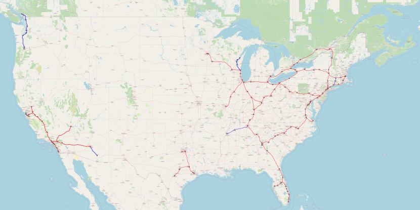

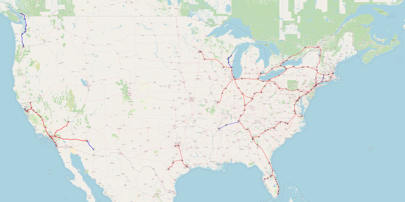

