Streaming High-Speed Rail Crayoning
People are sharing various maps of the high-speed rail network the US could build if it were interested in alternative transportation, and I promised I’d make one myself. I did this on camera on Twitch a week ago but was not finished, so I streamed it again just now – this is going to be a regular occurrence, always at 18:00 my time every Saturday. There’s a recording, but Twitch is being weird about letting me upload it, so it might make it to YouTube instead.
Here is the map:
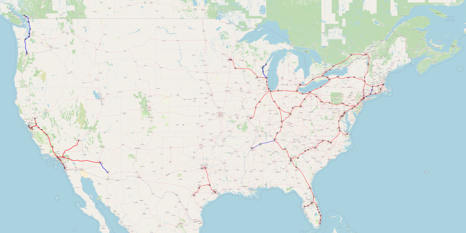
A full-size image can be found here. Red lines are high-speed rail. Blue lines are marginal lines: New Haven-Springfield and Milwaukee-Green Bay are good legacy lines that may or may not work as full HSR (the former probably better than the latter), while Nashville-Memphis, the Pacific Northwest system, and Phoenix-Tucson are marginal between no service at all and HSR.
Florida High-Speed Rail
I did the calculations for Atlanta-Florida on camera. I was surprised that it turned out to work out well, even with semi-decent return on investment based on my Metcalfe’s law formulas, around 3%. The rub is that Orlando is pretty big, and even though it is sprawl hell, it is also an unusually strong tourist destination, and the rail line would serve Disney World and Daytona Beach. This makes me more confident in a formula trained on Japanese and European cities with public transit than a connection between two random no-transit medium size cities like Cleveland and Cincinnati.
This itself is an example of Metcalfe’s law in action: the Miami-Orlando-Tampa system by itself only returns 2.2% per the formula, and an extension to Jacksonville 2.6%. I also have more certainty in the figures for the larger system, because the impact of sprawl on mode choice is smaller when distances get longer, because it doesn’t affect the air/rail mode choice as much as the car/rail mode choice.
Even at medium distances, observe that the South Florida urban area is linear, around 20 km wide but more than 100 long, which makes intercity rail service more reasonable. Every county can have a stop, and if the 0.8 exponent in the gravity model formula is applied to counties separately, then the sum rises to 6.1, whereas 7^0.8 = 4.74, which means that this refinement provides a 28% boost to ridership. Orlando is not linear, but its subsidiary metro areas, Lakeside and Daytona Beach, could get stops as well.
Alignment questions
I drew the system in a zoom level 7 on OpenStreetMap, which is too high-altitude to see individual railroads. I tried to approximate existing rail alignments that are worth using, but it’s not perfect, so please do not take the map as any assertion about pixel-level alignment, and even some station decisions can be quibbled with.
However, please do take the map as a definitive assertion about macro-scale alignments. The Northeast Corridor should go via I-95 and not via Hartford. This decision is fairly close and could go either way, though the benefits of HSR in the Northeast are so great that the absolute magnitude of such decisions remains momentous. Elsewhere, the Chicago-Minneapolis line could go along I-94 via Eau Claire or via a more southerly route via Rochester and the Mayo Clinic; I’ve gone back and forth on this, and it’s a second-order question, but I think the Mayo Clinic generates more trips, probably. The Albany-Montreal route could be entirely in the state of New York or take a slight detour through easier terrain in Vermont, which is likely cheaper. Toronto-Ottawa could go via Kingston or Peterborough, but the Peterborough route looks more direct. Chicago-St. Louis is sometimes proposed to detour via Champaign rather than go straight via Bloomington, but the benefit of serving UIUC probably doesn’t justify the extra cost. North Carolina HSR could go via the Triad or direct from Raleigh to Charlotte, but the model says the benefit of serving Greensboro is much greater than that of slightly faster trips coming from bypassing the Triad. Texas is a compromise route extending the under-construction line to Downtown Houston and creating a new leg connecting this system to Austin and San Antonio.
The most contentious questions are in California. HSR there should go via a partially high-speed coastal alignment from San Diego up to Los Angeles, then up the Grapevine and Tejon Pass, then across Altamont Pass and a Dumbarton tunnel. None of these decisions is close, and the official alignment decisions to detour via the Inland Empire and Palmdale and to go via Pacheco are all bad and played a role in the failure of the project. Los Angeles-San Diego is in a way the most frustrating: it was left to a future phase, but a medium-speed rail alignment along the coast could be done relatively quickly with electrification and some strategic investments, speeding up trains to about 1:45.
Frequency
I talked about frequency a little bit in the video, but not in much detail. The biggest problem is that Philadelphia is set up poorly: ideally trains coming from New York should branch to either Washington or Pittsburgh, but instead, 30th Street Station requires New York-Pittsburgh trains to reverse direction. This can be handled through actual reversal, as is done today at Frankfurt, with 4-minute turnarounds (cf. 10 at Philadelphia), or through having New York-Pittsburgh trains skip Philadelphia, as was historically done, with a stop at North Philadelphia instead.
With that in mind, my best guess, based partly on the model and partly on intra-metropolitan fudge factors like New York-New Haven, is as follows:
- 8 tph New York-Boston, 4 New York-Springfield
- 8 tph New York-Washington, 4 New York-Pittsburgh-Cleveland, 4 Washington-Philadelphia-Pittsburgh-Cleveland
- 8 tph New York-Albany, 4 short Boston-Albany, 8 Albany-Buffalo (4 short), 4 Buffalo-Toronto, 4 Albany-Montreal, 2 short Buffalo-Cleveland
- 2 tph Cleveland-Detroit, 4 (2 short) Cleveland-Chicago, 2 Chicago-Detroit, 2 Cleveland-Louisville
- 4 tph Chicago-Milwaukee, 2 Milwaukee-Minneapolis
- 2 short tph Chicago-St. Louis
- 4 tph Chicago-Indianapolis, 2 Indianapolis-Cincinnati, 2 Indianapolis-Atlanta
- 2 short tph Nashville-Memphis
- 6 tph Washington-Richmond, 2 Richmond-Norfolk, 4 Richmond-Charlotte, 2 Charlotte-Atlanta
- 2 short tph Miami-Tampa, 2 Miami-Atlanta, 2 Atlanta-Tampa
- 2 short tph Houston-DFW, 2 short DFW-San Antonio, 2 short Houston-San Antonio
- 2 short tph Vancouver-Portland (at best)
- 4 tph Los Angeles-San Diego, 2 Los Angeles-Phoenix, 2 Los Angeles-Las Vegas
- 2 tph Los Angeles-San Francisco, 2 Los Angeles-San Jose, 2 Los Angeles-Sacramento, 2 San Francisco-Sacramento

I’d love to see an article sometime about the costs and design choices around the Bay Area Caltrain. e.g. Palo Alto has been considering lowering the line into a trench or tunnel or elevated line, but ultimately rejected all of them after finding the expected costs in the billions https://www.paloaltoonline.com/news/2021/03/16/report-recommends-closing-churchill-avenue-at-caltrain-tracks
Part of the challenge seems to be that the line is still used occasionally for some freight traffic which can only handle a 1% grade.
This 171 page report goes into a lot of depth about the challenges. https://connectingpaloalto.com/wp-content/uploads/2021/03/XCAP-Final-Report.pdf
Caltrain had a guillotine clause permitting it to kick out the freight trains, which were unprofitable, in case of a change to the line making it incompatible with freight operations. This was inserted into the trackage rights agreement in expectation of a BART takeover, but could equally have been used for grade separations with EMU-only grades. Unfortunately, I think Caltrain gave up this clause.
That 1% grade thing could be dealt with using a LastMileDiesel or LastMileBattery locomotive (which would be useful for Caltrain anyways. In that situation, a freight train would have to be pretty heavy to cause problems with the grades. In short: don’t run underpowered (diesel hauled) freight trains when we talk serious railroading…
“Freight” can handle greater than 1% grades.
As is usual with Caltrain, they make up their own bullshit “standards” — generally somehow based on 19th century steam practice, or simply pulled from their rectums — and use these “standards” to eliminate all useful or cost-effective measures.
Anyway, Caltrain’s own “design standards” are OK with 2%.
A hidden but in some ways worse problem are the AREMA (steam-era, freight) design requirements for vertical curves, ie over-length transitions between different grades. AREMA (and hence Caltrain) want a “recommented maximum vertical acceleration” of 0.10 ft/sec^2 (0.03048 ms-2) for freight, which ends up translating to 632% longer vertical transitions than normal first-world rail infrastructure, eg Germany’s where standard (not minimum) vertical radius in metres for all traffic is 0.4 v^2 where v is kmh. In AREMA-ese this translates to r = 2.53 v^2. (Interestingly the AREMA standard for passenger traffic isn’t that much worse than DB-Netz — 0.4217 v^2)
Caltrain then combine this AREMA “standard” with their “standard” freight design speed of 60mph — despite that the actual freight speed limit on the entire corridor today is 50mph! — and a “standard” 1% grade to get incredibly long vertical transitions to incredibly shallow elevation changes, resulting in “rail” grade separation projects that turn into hugely over-extended rail construction combined with massive and totally unnecessary road reconstruction (the rails “can’t” rise enough, so all the roads “have” to be excavated down as well, and there “has” to be extensive water, sewer, gas, telecom, etc relocation).
But their hands are tied! By “standards”.
Death is too kind a fate.
Map makes a lot sense to me, but I think St. Louis-Kansas City would make sense. And if you went Atlanta to Mobile to New Orleans to Houston and San Antonio to El Paso to Phoenix you have a transcontinental route… lol. Also What about Salt Lake City-Vegas? And how could Denver and the Front Range fit in?
Salt Lake City and Las Vegas are probably the two most culturally dissimilar big cities you can find in America…
I haven’t run the numbers, but el Paso is too small and isolated to get any service. Your east west route only makes sense at all so you can brag the country is connected. I did run the north to Denver numbers and they don’t work .
There is one wildcard in there though. El Paso does have a significant military base. If the military decides to use this route for their purposes they can add enough trips to make it work out.
Alon, have you ever looked at using a radiation model instead of a gravity model? I know its not standard in transportation planning…
From the abstract:
Introduced in its contemporary form by George Kingsley Zipf in 1946, but with roots that go back to the work of Gaspard Monge in the 18th century, the gravity law is the prevailing framework to predict population movement, cargo shipping volume, inter-city phone calls, as well as bilateral trade flows between nations. Despite its widespread use, it relies on adjustable parameters that vary from region to region and suffers from known analytic inconsistencies. Here we introduce a stochastic process capturing local mobility decisions that helps us analytically derive commuting and mobility fluxes that require as input only information on the population distribution. The resulting radiation model predicts mobility patterns in good agreement with mobility and transport patterns observed in a wide range of phenomena, from long-term migration patterns to communication volume between different regions. Given its parameter-free nature, the model can be applied in areas where we lack previous mobility measurements, significantly improving the predictive accuracy of most of phenomena affected by mobility and transport processes.
https://arxiv.org/abs/1111.0586
Ugh, the nature version is prettier: https://www.nature.com/articles/nature10856
Two things about the paper seem questionable.
1. The model assumes a fixed rate of travel , rather than variable rates of travel. This makes sense for commuting because people only have one job, but intercity travel is different, not everyone undertakes it equally. This matters because the presence of
  in the denominator implies that adding population to a third city means less travel between the first and second cities, which is justified in the case of commuting but not intercity travel or migration.
2. The commuting data used has a GIGO problem – at long range, it doesn’t describe actual commutes. The county-to-couty dataset shows some people commuting from LA County to New York County, which isn’t literally people flying in and out every day, but probably describes second homes.
I guess I’m not up to date on travel models. Are there gravity models that predict variable rates of travel?
The standard gravity model formula has travel rates depending on nearby population – probability of travel depends on what there is to travel to.
Click to access quest21.pdf
It’s not “where do you work most of the year”. The question is “where did you work last week?” It’s catching people temporarily someplace odd. The last ACS I looked at had people working in Albany County NY who supposedly live in Hawaii. They were in a hotel room in Albany county that week. And it’s persons “who is living or staying at this address for more than 2 months.” .There will be telephone calls to the help desk number for people who are .. itinerant.
I’d have thought beyond ~60-90 minutes the vast majority of travel is leisure travel not commuting. I believe 90% of flight passengers are leisure travellers these days – and that was pre-pandemic.
The fastest growing travel sector before the plague was vfr (“visiting friends and relatives”) which is also the most price sensitive
There is also business travel at longer time. You are safe to assume that nobody commutes that long every day. However 90 minutes once a week isn’t unreasonable, in person meetings at headquarters can be useful. Or sales / tech support to customers.
Shopping and.clubs can get interesting nobody will take HSR to basic groceries, but there might be a store specializing in weird things (German sausages, or whatever they eat in Kenya…) you might have an odd hobby that means no local supply, such stores often host clubs worth a monthly trip.
The ability to see friends and family as Herbert noted is not to be overlooked
I’m surprised that the formula wants to send 8tph toward Albany and Buffalo. The Hudson line has so much less ridership than the New Haven line, and the upstate cities are far away and not that large. And I’d also have thought there would be more demand from NYC-DC-points south than NYC-Boston.
The way I always thought about scheduling was, suppose there’s a train every 5 min, regularly spaced, in the bottleneck between NYC and Philly. Given the population imbalance it seems like southbound you’d want to send them Washington-Washington-Washington-Pittsburgh (so 3tph to Pittsburgh which should be enough). And then you can plug (some of) the gaps in the southbound schedule using trains that are coming in from Pittsburgh. Going north from NYC you could send every other train to Boston (giving a steady 10 min frequency), and alternate the others between Albany and Springfield. If this isn’t enough service then it seems like reliability might suggest longer trains rather than more trains…
Agree with sg, some of those proposed frequencies really are in the realm of fantasy. A train every 7.5min between Pittsburgh and Cleveland? Every 10min Washington-Richmond? If that’s what your model is producing then something is wrong with your model.
I get the impression that that’s because of where the cities are, not necessarily because of the strength of that intermediate trip pair.
The formula probably wants to send 6-7 tph on Empire West, I’m trying hard to avoid odd numbers. The rounding to 8 is ambitious but it’s not that fantastic. NY-Albany is not just about Upstate but also NY-Montreal and NY-Toronto, and Albany-Buffalo is not just about Upstate but also about Boston-Toronto. Likewise, Pittsburgh-Cleveland frequency is very high, not because of connections between these two cities but because of connections between most of the Northeast and most of the Midwest: NY-Detroit, NY-Chicago, NY-Cleveland, Philly-Cleveland, DC-Cleveland, etc.
City pairs like NY-Chicago and NY-Detroit are really stretching the limits of HSR though. Even if you punch a 350km/h line the whole way through the Appalachians, Detroit would be 4h+ from NY, and Chicago 5h+. Unless you ban flying they’re going to struggle for mode share. The lines might still be viable, but you’re really looking at something more like 2tph for the Philly-Toledo stretch in the middle, not 6-8tph.
I would also question a model that thinks that Albany-Montreal or Richmond-Charlotte would require 4tph, but Dallas-Houston the equivalent of 1tph. Or that demand for Atlanta-Tampa would be double that of Tampa-Miami (it would be the reverse, I should think).
A more realistic system would give a 2tph Takt to all these lines (with train length modified to cater to demand variables), with the exception of Boston-Washington which could be more in the 4-6tph range. Have passengers interchange rather than overlapping services giving you ridiculously high frequencies in lowly populated parts of the country like western Pennsylvania.
NY-Chicago is the same trip time by HSR as Paris-Nice is today by a combo of HSR and a slog on the Marseille-Ventimiglia line. The mode share isn’t going to be huge, but the model’s 3.1 million prediction is reasonable by the standards of eve-of-corona air travel, which is 4.7 million. NY-Detroit, about an hour shorter than NY-Chicago, is at a point where HSR can get good modal split vs. air and also where the preexisting car travel market to be poached isn’t zero.
Atlanta-Tampa is a corner case, yes, coming from the lack of a good transfer opportunity in Orlando :(. The rest are pretty reasonable if you think in systemwide terms, for example Albany-Montreal also includes New York-Montreal and Boston-Montreal, and Richmond-Charlotte includes New York-Charlotte, DC-Charlotte, and DC-Atlanta.
3.1m passengers a year is still under 8500 a day, which is good for about one 16-car train an hour at 50% loading. Intermediate stops like Cleveland and Pittsburgh would probably add enough patronage for another hourly train. So 2tph, like I said.
The Paris-Nice TGV works because the train zips to the outskirts of Marseille in three hours, then hugs the coastline to Nice, making multiple stops across a linear stretch of land that is pretty much inhabited the whole way across (much of which has difficulty accessing local airports). That’s very different to the population distribution of NY and Chicago.
Don’t get me wrong, I personally would choose to catch a 5:30h train over a flight, and there are others like me, but we would very much be in the minority.
And I don’t get why your model rates the PNW so poorly, when this is really prime HSR territory. It seems like anything within 1000km of NY gets supercharged, even if the city actually has very little cultural or economic ties to NY (e.g. Montreal, Charlotte, Cleveland), while underestimating closely integrated self-contained regions like the PNW, Texas Triangle, Florida.
People travel to bigger cities more than to smaller cities. That’s what powers the Shinkansen, KTX, TGV…
NY-Chicago by itself doesn’t fill trains, you’re right. But together with all the other city pairs using the same line, it does. Looking just at passengers traveling over the Cleveland-Chicago link, we have, if you believe the model’s raw numbers:
Chicago-NY: 3.12
Chicago-Philly: 1.56
Chicago-DC: 1.48
Chicago-Harrisburg: 0.34
Chicago-Pittsburgh: 1.75
Chicago-Cleveland: 3.77
Chicago-Toledo: 1.58 (Toledo-Cleveland-and-Northeast is more but is shared with Cleveland-Detroit)
Chicago-South Bend: 1.58 (South Bend-Toledo-and-points-east is actually a bit more, 2.25, but less than if you add below)
Chicago-Buffalo: 0.76
Chicago-Rochester: 0.55
Chicago-Syracuse: 0.34
Chicago-Albany: 0.32
Chicago-Boston: 1.03
Milwaukee-all above except Upstate NY and Boston: 3.55 (my second Metcalfe’s law has a breakdown; add 0.44 for South Bend)
St. Louis-Cleveland: 0.43
St. Louis-Toledo: 0.22
St. Louis-South Bend: 0.42
Madison-Cleveland: 0.25
Madison-Toledo: 0.15
Madison-South Bend: 0.23
MSP-Cleveland: 0.37
MSP-Toledo: 0.18
MSP-South Bend: 0.3
This totals 24.28, which fills four 16-car trains an hour in each direction to 50%, in fact probably more because 5-hour trips to New York can happen over maybe 13 daily service hours and not 15. The 2 long, 2 short system means 67% seat occupancy on this section, e.g. if some of these markets (St. Louis-Cleveland, Chicago-Upstate NY/Boston) are too speculative.
The PNW isn’t that big; the biggest city is 4M people, and Portland is 2M. Vancouver is in between but also across an international border. In the same vein, if Detroit, Cleveland and Pittsburgh existed in a vacuum you probably wouldn’t build 220MPH HSR either just to serve those three (and the towns along the way)
Nice-Paris gets 30% mode share is is 5:30 IIRC. Seems not unreasonable to think a new build line between NYC and Chicago might do better.
How many tph can you squeeze in between NYC and Philly before you have to eight-track the NEC? I figure you can’t go full Moscow Metro at HSR speeds…
Six tracking it would be a first step. Four across the Hudson would be nice too. If it ever needs 8 tracks the two new ones can be out along the New Jersey Turnpike. People who want to get from Virginia to New York or New England don’t have to stop in Philadelphia.
“People travel to bigger cities more than to smaller cities.”
That’s the problem with your model. Let’s say you have two islands looking to build HSR. Island 1 has City A and City B, both 1million people, 300km away from each other. Island 2 has City C and City D, both 10million people, also 300km away from each other. Using the product of the populations would suggest that Island 2’s HSR would have 100 times the ridership of Island 1. I know you introduced a 0.8 factor into your model, but this brings it down to *only* 64 times the ridership. Even that seems way off. Why would the average person in a city of 10million people be more than six times more likely to travel intercity compared to the average person in a city of 1million people?
Gravity models work well when you compare different markets in an integrated region. So it works well for predicting HSR ridership in France because virtually all the major cities in the country fall within Paris’s gravitational pull.
They don’t work so well when comparing isolated regions with each other. This applies to the US with places like PNW and Texas. There aren’t hordes of people from Portland travelling to NY and LA just because they’re bigger cities. But they DO travel to Seattle a lot because it’s nearby and the two cities have very close ties with one another (people have relatives there, businesses have branch offices there, their sports teams have rivalries, etc.). And that’s with the present poor state of transport connections. HSR would only increase this tendency, probably exponentially so. The same goes for Dallas-Houston.
To give a provocative example, your model would probably give miserable results for Edmonton-Calgary. But I actually think a line there would perform quite well. They’re two 1m+ cities, in perfect HSR range (300km distance, with nothing but flat plains between them, so construction would be cheap), and they relate way more to each other than they do anywhere else. The average person in Edmonton is far more likely to travel to Calgary than Toronto, let alone Chicago, LA or NY.
Current traffic on the NEC south of NY Penn is approximately 3 time that north of it, both on the corridor as a whole and just for Acela. Any frequency plan needs to account for this.
Alon’s plan has 12 tph on the NEC from the south (8 from DC, 4 from Pitt) and 12 from the north (8 Bos, 4 Springfield/Hartford). This is not the right balance.
It is also out of balance that Albany has as many trains to NY (8tph) as DC does. Even accounting for this as through traffic to Toronto and Montreal doesn’t help, since DC+Baltimore is about the same as Tor+Mont, DC is closer to NY than both, and Tor/Mont are one the wrong side of a border (both) and a language barrier (Mont.)
Even more strange, Albany has more trains departing in all directions (24 tph, 8 NY, 8 Buff/Tor, 4 Bos, 4 Mont) than DC does (18 tph, 8 NY, 4 Pitt, 6 Richmond). Knowing the size and importance of the cities this doesn’t make sense. Even the Olten effect (Olten, a town in Switzerland with a ton of service since it is where the lines from Zurich-Bern and Lucerne-Basel cross) doesn’t justify it. Yes, from Albany you can get to NY/Bos/Tor/Mont, but the population of NEC states south of NY is approximately the same as all of Canada. Yes, not all of it is on the NEC, but still, Toronto is as far from NY as DC is from Bos – there are serious differences of scale here. Either upstate NY is being overserved, DC underserved, or both.
This N-S imbalance at NY is another reason HSR to Bos should go through both Providence and Hartford; the branches can split service so the higher volume of trains from the south can all through route to Bos. In fact, in a situation where Penn is connected to Grand Central, it might not be unreasonable that the sum of all trains to Albany, Hartford and Providence equals the number coming from the south. I.E. if there are 8 tph from DC and 4 tph from Pitt/Phila, then there would be 4 tph to Albany (1 tph Mont, 1 tph Buffalo, 2 tph Tor?), 4 tph Hartford to Bos and 4 tph Providence to Bos.
I mean, I imagine that part of the current DC/Boston split is the lower average speed on the NY-BOS segment, which at 66MPH is barely faster than the highway speed limit. I get the sense that most people not driving between NY-BOS are using one of the many buses that ply the route, and higher speed trains (and more capacity allowing for cheaper tickets) would wipe out a good chunk of that.
Yes, but DC-NY is only running at 82.2 mph and MegaBus is running 14 daily trips DC-NY. Greyhound offers 8 daily trips DC-NY but 5 daily NY-Bos. Increasing DC-NY express train speed to 115mph+ should see a huge increase in ridership from the south as well as the north (the Regional all-stop service could be running about as fast as the Acela does today). There are simply far more people in DC/Baltimore/Phila than there are in Hartford/Providence/Boston, so the imbalance will continue.
Neat map! One way to send NYC-PIT trains west without a turn is via the CCCC, diverting at Morrisville, then via CSX’s relatively straight line to the Fox Chase and then down to CCCC. Some of that very slow SEPTA infrastructure could be sped up. I suspect that the slower travel time serving City Centre Philly instead of just 30th St would offset ridership loss from slower travel times. It would also allow for splitting ridership from PIT to points east with Philly bound pax using the City Centre option and NYC bound using the Harrisburg Subway connection
The Philadelphia turnaround today includes an engine change. If the Philly-Pittsburgh route were electrified, that would eliminate the engine change and cut down on the dwell time.
I think I blogged many years ago about it but can’t find the post anymore. Yeah, you can hook intercity trains through the C4 – probably the fastest way is a connection between North Philly and North Broad, which requires some annoying construction but the order of magnitude is low hundreds of millions, not billions.
Or they can just use the grade separated tracks on the northwest side of Zoo to get from the Pittsburgh Mainline to the New York Branch. There’s enough demand for trains to 30th Street and beyond and trains that bypass downtown Philadelphia on their way to New York.
Nec-o-the-Future has Amtrak burrowing across Philadelphia to serve City Hall and the airport. Gawd only knows why someone from outside metro Philadelphia would use PHL. Perpendicular to the perfectly good station a few blocks away from City Hall at Suburban. There is enough demand to have trains that loop through Philadelphia and trains that don’t. The foamers could even get all frothy that the Philadelphia-New York Hikari bounce back and forth by using the Trenton line and the West Trenton line. Without building anything other than electrifying between West Trenton and Newark.
That would reduce tunnel capacity for a greatly upgraded, high(er) frequency RER-style service on SEPTA Regional Rail, which Philly needs far more, which the City and SEPTA are tentatively planning for in their newly released Transit plan (https://www.phila.gov/documents/philadelphia-transit-plan/ ), and which was the original purpose the CCCC was built for in the first place. I don’t know how transit activists in Philly would feel, but I suspect the average Philly transit rider would choose more RER trains serving their own daily needs over a slightly faster HSR ride for outsiders passing through at the expense of reduced local service, and I bet the City and SEPTA would feel the same. Also, SEPTA giving up CCCC slots to Amtrak, after a brief glimpse at Amtrak’s relationship with NY commuter railroads (the geographically closest analogous situation being NY Penn and approaches, which Amtrak through runs)? Lol.
My rule of thumb, service for outsiders passing through any community should not reduce capacity/quality of local service; if all other organizational & electronics options have been exhausted and you still need capacity for the long-distance stuff, then spend some state/nat’l $$ and pour a little concrete, don’t rob the locals. (Similar to my rule-of-thumb for infrastructure: use existing ROW and open or industrial space first, with displacing people from homes as the absolute last resort, and then only the minimum absolutely necessary to build what is absolutely necessary–a little inconvenience, and a few extra $$ from big entities that can pay, is better then even a little injustice. And takings should be aimed at targets that can better afford to withstand the loss and move somewhere equally or more desirable, i.e. a few mansions over a whole poor neighborhood.)
The plan calls for trains every 15 minutes on every branch. There are at most 7 branches on a single side of the CCCC, so that’s 28tph. With four tracks on the CCCC there’s definitely room for both. Maybe not for 20 HSR tph like this seems to be suggesting but at that point you probably want a whole new two-track tunnel anyways.
Since the four tracks of the CCCC should be able to support 48 tph per direction (24 tph per track) a 28 tph commuter schedule actually should have room for 20 tph intercity. Note I only see 12 tph though, 8 to DC and 4 to Pittsburgh. Dwell time could be an issue since intercity trains might want to stop longer for people with luggage, but you can give each HSR train two slots and an extra 2.5 min dwell if needed. If only Pitt bound trains at 4 tph are using CCCC, that would be 8 tph of tunnel capacity and 40 tph left for Philly RER.
Why would people in Washington DC need to see Jeffferson Station if they want to get to New York or New England? The SEPTA schedule for the Trenton Line takes ten minutes to get from North Philadelphia to 30th Street. Or 17 on the Doylestown schedule to get from North Broad to 30th Street. Is Suburban so scenic it’s worth wandering around in Philadelphia?
I imagine people in DC (any NY, etc, etc) going to downtown Philadelphia might want to get off there instead of a mile away. No one going from DC to NY wants to see BWI or Wilmington, but the train “wanders around” Maryland and Delaware anyway.
In any event I was not necessarily advocating that inter-city trains use the CCCC, just that with four tracks there is sufficient capacity that it could. It is also possible that some but not all service goes through suburban: Keystone trains to avoid a reversing movement at 30th is possible (also since Harrisburg is the capital there may be extra demand for quick travel to/from downtown Phila.), having Limited/Express HSR stick to 30th St while the Regionals make a Suburban station stop is another, as Suburban has the best subway connectivity in Phila. (if DC ever electrified its network there is a case to have all Regionals stop at L’Enfant Plaza – or maybe Acela start there? – since it is served by every Metro line vice Union Station only being served by the Red line).
There’s four or more tracks of railroad between New Haven and Wilmington. Except for the bottleneck under the Hudson. There can be trains that are relentlessly drawn to every platform they pass, trains that stop at a lot of them and trains that stop at few.
Unless there is a wormhole we don’t know about passing through BWI on very very straight tracks makes it possible to get from DC to Baltimore. Using the lower level at 30th Street saves 7 minutes according to the SEPTA schedules. Philadelphia has enough demand that there can be New York express trains passing through and Philadelphia locals from Washington, Harrisburg or New York.
There aren’t any wormholes in the vicinity of Wilmington either. Fixing the curves on either side of Wilmington will be very very expensive. Don’t fix them. Since the train is stopping at Wilmington it doesn’t matter there are sharp curves on either side of the station. The tracks will still be there for SEPTA service. If there are 8 trains an hour from DC to New York and beyond two of them can divert to downtown Wilmington and the other six can be out along the freight tracks that are much straighter. One of them can be train that stops at New Carrolton, Cornwells Heights, Princeton Junction and New Brunswick in addition to the ones the express trains stop at. There are enough people along the former Reading/Jersey Central route that there could a third one. They’d get to see the underbelly of North Philadelphia as they pass through North Broad. Slower than if they were looking down on North Broad from North Philadelphia but if you are starting out in Langhorne or Bound Brook the door-to-door trip time is lower. Getting to and parking at a NEC station can be a PITA.
There is enough demand between New Haven and Wilmington for there to be two or three levels of service. On the intercity system and the commuter systems. I”m sorry it’s not a blue line and green line and things get complicated.
So under Metcalfe’s law, there won’t enough demand to justify building Sacramento-Redding or Portland-Eugene lines?
Nope. I think even without the mountains it doesn’t pencil out; with the mountains, you need an SF-size city in the middle to make this work.
I dunno. The US is a rich country and can afford some extravagance. Air traffic is very heavy on the West Coast, and not all the airports are known for reliability, especially San Francisco’s. Seattle to San Francisco is only 800 miles, and on a fast train like what’s being built in California right now, it’d take about 4.5 hours. That’s very competitive with flying, it’s much more comfortable and pretty to look at, and if we’re *really* going to take carbon reduction seriously, we’re going to have to move to trains from flying. Hell, in an extra two hours or so, you could reach LA. It’s not tremendously longer than flying, and if we stop subsidizing air travel, say, in favor of trains, I think I a lot of people would take the budget option. Again, it’d be cheaper, more comfortable, the sights are gorgeous, and the travel time is only around two to three hours longer depending on the trip. That isn’t bad, and it’s more reliable than the mountain passes by car or the weather conditions around San Francisco. LAX wouldn’t need expansion which would make a lot of people happy. I think a full West Coast line from Vancouver, BC to Tijuana, México would be a very smart idea. People are still moving to the region as well, so it’s not like the population will likely be dropping. The 136 miles from Ashland, OR to Redding, CA will likely be the roughest to build, but it’s certainly doable. There are already railroads and highways through these places, and modern base tunneling has been shown to be very effective in this kind of terrain. Think big! Isn’t that what the US is supposedly known for?
From a solely carbon perspective, I’d imagine electrifying planes will pencil out as a better investment than a 4.5 hour HSR between Seattle and SF. The carbon emitted to build that rail line will be immense.
Portland to San Francisco would be like building HSR between London and Milan, investing in going under the Channel and through the Alps, except instead of France you have effectively zero people.
Vancouver, Seattle, Portland, San Francisco and Oakland airports are all looking at major expansion plans, all of which will also emit huge amounts of carbon, and that’s assuming electric planes even become widespread in the near-future.
Re: SFO / OAK expansion plans
There may be plans, but the starting gates are chained and welded shut. OAK has weather and wetland issues. SFO has a cheek-by-jowl issue with its current runways and the fix would require filling in a sizeable chunk of the bay. And fog / rain related air traffic issues can strangle SFO’s throughput (back in the 90’s I could NOT see the runway at times from my office window due to heavy fog).
A more feasible solution would be to take a chunk of Travis AFB (Fairfield, CA) and put a civilian enclave on it served by a rail tunnel or two. Better weather and fewer people to upset with aircraft noise.
Electric planes won’t be useful for long haul routes any time soon, battery energy density is just too low. Even SF-Seattle is too far for them. Electric plane range coincides with HSR range, so there is little place for commercial electric planes, except for where there are geographic obstacles to HSR on a short route (Hong Kong-Taipei, Barcelona-Palma, etc.)
There are alternatives being explored, like hydrogen or synthetic avgas, which have higher energy density.
The point remains that the construction of HSR isn’t zero carbon impact, and the travel times are so much longer that it’s probably not worth building, unless you’re some railfan who loves sleepers because they exist, or you seriously think the government is going to make everyone traveling across the country take days-long trips instead of a 6 hour jaunt across the continent.
The snorkels for the passengers on the high speed trains between North America and Europe would be too long, there will always be airplanes. The industrial chemists have been poking at Fischer–Tropsch for almost a century. You dump carbon and hydrogen in one side, from a wide range of choices and whatever you want come out the other side. We don’t do it because distilling dead dinosaur ooze is cheaper. It might remain cheaper to boil ooze and use carbon sequestration to mitigate that. The industrial chemists can poke at the problems.
We continue to boil ooze because synthetic fuel is roughly double the price. If half my airfare is fuel costs, the price of fuel doubles my fare goes up 50 percent. That’s not a deal breaker except for people who squeeze pennies until Lincoln screams.
…………….. I’ve always had to remind my corporate travel agent that I’m one of the well paid peons who gets paid by the hour, not a salaried executive. Having me cool my heels in Cleveland to use a connecting flight cost more money than putting me on a non-stop. Or Chicago or Atlanta or Dallas or…. A 12 hour train trip, coast to coast, costs more than twice as much as a six hour flight because westbound I start getting overtime in Colorado.
Am I misreading or was SB asking about the tails off of Portland and Sacramento before you hit the mountains at the head of the Sacramento and Willamette Valleys?
I read the same as you
There are no mountains between Sacramento and Redding: the northern Central Valley is almost completely flat. There are also no mountains between Portland and Eugene. I believe the Portland-Eugene extension could make sense, with stops in Salem (160k population, just 50 miles via rail from Portland, State capital), Albany/Corvaillis, and Eugene (2rd largest urbanized in the State, ~200k, with a large university). There should be enough demand between in-State travel to Porland, plus the additional trips to Seattle. Or are you thinking that 200 km/h mid-speed service along existing alignements is good enough for this market, so true HSR is unnecessary?
Does it make sense to extend the San Diego line across the border to Tijuana?
Politically, the best that is probably achievable is a HSR terminal at San Ysidro where you just walk across. Today Mexico has zero US preclearance facilities and unfortunately I don’t see that changing any time soon.
Not with the current Mexican ecconomy. The average person is too poor to afford the prices HSR would need to work in the US. Going to Canada you can assume and be close enough that everybody is equally wealthy on either side of the border and so can afford ticket prices on either side. (Even still these underperform in general) The southern border doesn’t have nearly as many people who can afford the fare. They do have cheap labor so their side of the border should be able to make lines work for much less costs.
There are also safety concerns. I’m not sure I would want to take a train there, it is an easy target for some drug Lord.
The above problems should be fixable, but it isn’t easy.
Mexico is richer than China, though also more unequal
It depends on whether the US is willing to let go of 2-hour border delays.
For this exercise, are you assuming any border delays in your US-Canada trip pairs?
How hard would it be to connect the NEC to the correct side of 30th St with a curve at North Philadelphia? That entire area needs a rework anyways, since North Philadelphia and North Broad are so poorly connected.
Does 30th Street have a correct side? There’s trains going north. Or trains going south. And trains going east and trains going west. Which one is “correct”? Why does North Philadelphia need to be connected to North Broad?
Great Map Alon, I hope it gets built one day. Did you consider the quality of a metro areas local transit system, or just city populations in which cities to include in your network? I recently wrote a blog post about how Pittsburgh needs better local transit connections to its train station in order to support significantly better intercity rail service: https://connect-pgh.com/how-transit-can-support-better-intercity-rail-service-for-pittsburgh/
I think those improvements would need to be made either prior to or concurrently with a high speed rail development for the rail development to make financial sense.
Can’t see the video, which Alon Levy is already aware of. Some of the following rambling points may already have been addressed.
First, some comments on places I’ve been to:
1. Sacramento to Redding is really easy terrain, totally flat. Sacramento-Yuba-Chico-Redding should have very low costs. That said, I don’t think they would have high demand.
2. Houston to New Orleans is very flat and already has a straight rail alignment. Beaumont TX, Lake Charles LA, Lafayette LA and Baton Rouge LA have large enough populations to be intermediate destinations, and are well-spaced in a line. I suppose New Orleans may be too small to make this line viable, but I’m still a little surprised it doesn’t work.
2a. The Texas Triangle is correct to stay out of West Texas. It feels as desolate in person as it looks on a map.
3. Albany to Montreal via Burlington Vermont, instead of Plattsburgh NY, is absolutely the correct call. The east side of Lake Champlain is flatter than you may expect from a map, and the west side is way hillier than you may expect.
4. I’m trying to make a case to myself for Philly to Allenton/Bethlehem to Scranton/Wilkes Barre to Binghampton, but the terrain here really isn’t that great.
5. As an intermediate destination for Philly to Pittsburgh, Altoona makes more sense than Johnstown, because you can collect State College MSA. That said, this probably makes the alignment a lot rougher, and therefore doesn’t make sense for the line as a whole.
6. Chattanooga to Birmingham isn’t hard to build. That route parallels the ridgelines, and there is an existing alignment that is flat-ish and straight-ish. I have never been between Atlanta and Birmingham, but my feeling is that the terrain there is problematically rough.
6a. The eastern 20% of Chattanooga to Nashville is really rough terrain if you want a high speed alignment.
Places I’ve never been to:
1. From a map, Las Vegas to Phoenix looks like a pretty easy alignment. Heading east-southeast out of Los Angeles towards Phoenix is, topographically, super easy. Heading northeast towards Las Vegas is initially quite tough. I wonder if it might make sense to have both LA-LV and LA-Phoenix share an alignment heading ESE, and then have LA-LV break north at some point, maybe east of Joshua Tree NP. LA-LV becomes 100 miles longer, but you can build 60 fewer miles of track, you skip the topographically roughest part of LA-LV, and you drop 200 miles off of LV-Phoenix if you have a station at the separation point.
I’m trying to make a case to myself for Philly to Allenton/Bethlehem to Scranton/Wilkes Barre to Binghampton, but the terrain here really isn’t that great.
There aren’t many people there. Metro Scranton-Wilkes Barre is just over half a million and Binghamton is just under a quarter of million. Quarter of a million people flitting here there and everywhere works out to a bus once an hour to the HSR station in Syracuse.
Chattanooga to Birmingham
Metro Chattanooga is a million people. Metro Atlanta is almost 7 million. Beyond Chattanooga is Nashville with a metro area of 2 million. Beyond Atlanta is Charlotte with almost three million. Three million to the north or nine million to the northeast. Which one do they want?
It is passenger railroad. Where people are is important.
Sacramento-Redding is a 2h30 drive across 162 miles.
While it’s flat, you could build a medium-speed rail connection across that distance; full fat, 220MPH HSR probably isn’t needed. 110 or 125 would probably be fine.
Sacramento to Yuba (or Sac-Chico) should be a branch of a regional rail network built off of the current Capital Corridor, with other branches past Sac being to Auburn (existing) and Folsom, while southern branches past San Jose go to Hollister, Salinas and Monterrey (roughly, and in the process taking over Caltrain Service past Blossom Hill). There could be a regional service using the same tracks from Sac-Redding (not continuing to the Bay Area) but there is no where near enough people or travel demand to support HSR.
Both the current rail lines and I-20 from ATL-Birmingham are on mostly rolling hills or somewhat flat terrain with a few sections of mountains. They pass between larger ridge lines in the area just east of Anniston and mostly avoid any real problems in that section–any further north or south would hit much bigger ridges. The area immediately east of Birmingham itself is where the real problems would be. For I-20, that area was solved by blasting paths through the tops of the granite ridges, but the interstate still has a few decent climbs that wouldn’t be possible for rail. I am not sure of the exact path the existing rail lines take through that area. Looking at a map of the line suggests they had to use a much windier route than I-20 has used. I assume HSR would use tunnels through there. But you’re talking probably a few tunnels spread across a 5-10 mile stretch, which is nothing compared to what it would take to get across Pennsylvania
Does low-speed/Amtrak rail pencil-out from New Orleans to Jacksonville? It existed pre-Katrina.
No. I’ll follow up tomorrow but the short version is that a lot of railfans in the US overrate present-day Amtrak maps, which are based on the America of 100 years ago, in which NOLA and St. Louis were in relative terms more important.
The Albany-Montreal route could be entirely in the state of New York or take a slight detour through easier terrain in Vermont, which is likely cheaper.
The 19 millon people of New York State will find it easier to come up with the money for the local contribution for Saratoga Springs to the border on the New York side of Lake Champlain than the 600,000 in Vermont. And New York State already owns around half the land it would traverse. Might be marginally cheaper to construct in Vermont but there will be a lot of land to buy.
It will be on the west side of the lake. Vermont is aiming for a 60mph railroad between Rutland and Burlington, in the short term. Nudge it up to 90 or 110 where it’s cheap to do that, they can get to Saratoga Springs fast enough that changing trains to get to Boston or New York and beyond is competitive with flying or driving.
It doesn’t look like this is capturing things like Philadelphia-Montreal. Or, with customs and immigration done while the train is in motion between Saratoga Springs and Montreal, Washington D.C to Montreal.
More detailed, out the scope… Rochester.. The bus system is vestigial. Swooping into downtown probably isn’t worth it. Out at southern side the airport where there is a very straight ROW is good enough. If they insist the Toronto-Buffalo trains toddling around can extend to downtown Rochester. Custom and immigration while in motion between Rochester and Toronto looks like it has a very straight ROW to Niagara Falls, not Buffalo. The “local” traffic around the west side of the lake can have a different set of trains that make a lot of stops and does customs and immigration at the border. ( I haven’t been in Rochester in decades but not much has changed except for Kodak and Xerox abandoning downtown. The track and train station are just outside of downtown. Putting the main station out at the airport means the car rental and hotels etc. are combined and the parking lots aren’t in downtown. )
The 125 mph proposal from a few years ago had the combined Albany and Schenectady station out on the Thruway. They could extend the high frequency bus routes out there. Or extend them a few blocks from Downtown Albany to Rensselaer. And it’s very rare inland pine barren that is host to an endangered specie out there. Difficult if not impossible to be carving new ROW.
There’s usually froth about putting the Saratoga Springs station back in downtown. Meh. And it would be very very expensive. Out at I-87 means the parking lots are out there. The hotel shuttle buses and the ones for the race track, during the season, can go there. Might even have scheduled shuttle service to the hotels in Lake George. It would be an odd station. Platforms to and from Canada and U.S. platforms. So would Rochester.
Nashville-Memphis, the Pacific Northwest system, and Phoenix-Tucson are marginal between no service at all and HSR.
Memphis and Birmingham have almost exactly the same metro area population. Birmingham-Atlanta is three quarters of the distance of Memphis-Nashville. And Atlanta is a much bigger origin or destination. With Charlotte beyond it.
Phoenix-Tuscon should look better than BC-Washington-Oregon. Tuscon has Southern California and Las Vegas within in range. There is approximately nothing south of Portland OR or north of Vancouver BC.
…. Green Bay? https://en.wikipedia.org/wiki/Wisconsin_statistical_areas
Re: “nothing south of Portland OR” – there are 400k people in the Salem metro, 200k in Albany-Corvaillais, and 400k in the Eugene area, for a total of 1 million served by 3 stations along about 180 to 190 km of track (existing track is 202km, via I-5 is 177 km, or 110 miles). It’s a not a huge population, but it’s almost 1/2 as much as the core Portland metro area.
I’ve looked at this.https://en.wikipedia.org/wiki/Oregon_statistical_areas
400k people it’s iffy it’s worth it to build a station. It’s a not patch of asphalt with a bus shelter by the side of the track.
Keep the arithmetic very very easy. 365,000 people a year decide to make one round trip. Japanese level of ridership demand. That’s an average of 1,000 a day arriving and 1,000 a day departing. One 1,000 passenger train a day. Or perhaps you’d like ten one car trains a day? That’s two 50 passenger buses. Million people could be three car trains every 90 minutes or so.
1000 people a day would be twenty 50-pax buses, not two. And you would actually need more, since you cannot ensure demand will exactly fill each seat every time (an 1100 pax day will be followed by a 900-pax, 85 people wanting to travel at 9am means two busses but neither full, etc.)
Since Joeseph identified 1M pop, that would be approx. 2750 pax per day per your estimate. If the trains are 50% full coming into Portland (to account for uneven demand and so they can pick up Port-Sea pax) then you need 5500 seats per day. If the trains are 500 seats each (about an 8-car Siemens Velaro) then you have 11 tpd, or one an hour from 7 am to 6 pm. Not unreasonable if the Port-Sea link exists.
Two buses per hour unless you want them to all leave in one big clump like a 1,000 passenger train would.
Looking at the Willamette Valley as a whole it is reasonable. Your one 1,000 pax train per day for Salem could be two 500 pax trains per day (no one is suggesting 16 car trains on this route, 8 car is fine). Adding two for Eugene and one for Corvalis is 5 trains per day. Assume trains are at 50% capacity since they will need to pick up travelers to Seattle in Portland, and that is 10 trains per day. Or about a train per hour. Reasonable if the line connects to Portland and then to Seattle at HSR speed.
People don’t build very expensive to build and maintain HSR tracks for ten trains day.
My last sentence was written unclearly. HSR tracks south of Portland are not justified by demand. However, they should be electrified and HSR trainsets should provide the regional service with through running to the HSR tracks Port-Sea-Vanc.
Ten trains a day is certainly not huge, but even in rail heavy Switzerland there are regional lines that run 1 tph. With the population geography of the PNW, it just makes sense to run them from the Willamette Valley directly onto the HSR line.
Why can’t it be a bit of asphalt with a shelter by the track? The only transfers are to the local bus system, so if it more than a shelter it is a rain sheltering roof, with open sides (right now you build plenty of ventilation for diesel buses, though electric is coming soon which allows sides.
The first question is dwel time. If we run local transit style trains with four doors per car we can stop for one minute (airport trains do this ), and with stop/acceleration time the total lost is only two and a half minutes vs skipping the stop. If we want to run the fullest trains we can that means less doors per car, and thus longer dwell times, which quickly makes the impact on through riders large enough to skip the stop.
If we are running less than five TPH, we can single track large stretches with dual tracks only at times passing places. With Swiss as fast as necessary timing we can put in a stop at one of these places, and since the train is stopping we need enough less dual track as to pay for the station. (I figure 25 km of dual track is needed to safely allow passing trains to not slow down, experts probably have better numbers )
The point of this is if you are looking at a marginal route, you should stop in places that on better routes would be bypassed. If you have a strong route consider if the bypassed cities should get service by a third track (which also allows closing tracks for night maintenance while still running some service )
HSR generally needs lots of infrastructure improvements (embankments, cuts, tunnels, bridges, grade separations) to provide a straight ROW. These need to be done whether you want 1 track or 2, so the savings from single tracking are limited.
Also, I wonder about the safety aspects of single tracked HSR – head-on collisions seem like a bigger threat.
The floor of the car isn’t at the top of the rail so you need something so the wheelchairs can roll on and off? Which makes it much easier for the able bodied to get on and off but doing that isn’t cheap.
@Eric2 head on is why I said 25km to pass. You have to allow one minute after one train passes the switch for the other, then a minute for the switch to move, and assume that the switch detects a failure at the last moment, then allow plenty of stopping distance (error detection and fail safe is a must) You can play with the numbers above, at 300km/h I came up with just over 20, and I rounded up, 25 km out of every 100km makes the math easy. Obviously before building a real engineer needs to verify my numbers allow enough margin of safety.
I figure dual track is half again more than double, but I don’t have hard numbers. At 3TPH or less saving money this way makes sense. While you can in theory get 11 TPH (at 6TPH you have as much dual track as single), this way, the complexity of operations combined with the minimal savings make it not really feasible for more than 3TPH.
This exercise is about trying to get marginal cities some HSR, which shouldn’t be done until the much better lines are funded (political reasons and ease of construction might start such a line sooner)
I live in Portland and would love for a HSR line south to Eugene, but it’s probably not worth the expense. The Willamette Valley is just not that populous. However, it’s certainly a good candidate for an upgrade of the existing line to allow for medium speed trains. It’d be fairly simple to allow for 110 MPH trains with a reasonable frequency. Could even extend that service south to Cottage Grove without having to deal with the mountains.
Yes – there’s no need to build HSR when conventional rail will work. There are a string of biggish cities, all of which would spur demand for a couple of fast trains per hour, plus various small towns en route which could be served every hour or two. You could even throw in frequent regional service between Portland and Salem. The current alignment is good (but needs electrification and some grade separation), so I don’t see why you would sacrifice it for HSR when what you have is good enough to work with.
Why no service to New Orleans, Santa Fe or across the border into Mexico (there are two lines in this crayon that go across the border to Canada and there are some big Mexican towns just south of the border)
Since you mention Mexico, the big rail news this weekend (it’s freight, but …):
Canadian Pacific Railway on Sunday said it has agreed to buy Kansas City Southern for $25 billion in a cash-and-shares deal to create the first rail network connecting the United States, Mexico, and Canada.
The superiority of Tejon and Altamont over Tehachapi and Pacheco is absolute, but I am not sure the Inland Empire route to San Diego is wrong, for a few reasons:
1) HSR should go to at least Irvine no matter what, but the Coast route to SD is not great. It is curvy around San Juan Capistrano and again in La Jolla; it is single track between the beach and cliffs for part of the route, and runs through beach towns with at grade crossings for some of the rest. Should it be electrified and upgraded (both for commuter rail to LA and SD, and regional Surfliner service)? Yes, but I don’t see an easy way to run high-capacity-all-day double track along the whole route. And it would still be 30 min slower SD-LAUS than the IE route.
2) Population along the IE route is larger than along the coast (1.1M vs 0.9M) even without considering Riverside, which adds another 0.3M. There is no reason to run HSR along the coast, for a slower LA-SD time, while reaching a smaller secondary population shed, when the IE line is faster and larger.
3) Vegas baby, Vegas. The extra 1+ hr from LAUS means that SD to NorCal will always be at a disadvantage via HSR, but the 530 km from SD to Vegas is a perfect HSR range, with a flat route and no intermediate stops across the desert. But adding 30+ min via the coast then another 30+ min to backtrack to Cajon from LA hurts it. Better to go via the IE and make HSR dominant for SD-LV (since it is faster to LA anyway, the primary market).
As with Hartford v Providence (which I will discuss elsewhere) Coast vs IE to SD should be a “both” not an “either/or”. In an ideal world, the shorter Coast route to LA would be HSR, and the IE route would be regional rail. However, since a serviceable legacy route already exists along the Coast, there is no reason to re-build HSR there and new-build regional rail in the IE. Better to new-build the HSR where there is no route and serve multiple markets. That Alon is suggesting only upgrades along the coast, not true 250kph+ HSR, should firmly tilt in favor of the IE.
1) South of Irvine (or more precisely Mission Viejo), I think HSR should follow I-5 rather than the legacy tracks. I-5 is generally straighter, and doesn’t have the impacts on surrounding neighborhoods. (Similarly I think it should follow I-5 between Anaheim and Santa Ana – straighter than legacy rail on this segment, and serves Disneyland too. Between LA-Anaheim and Santa Ana-Mission Viejo the legacy rail is very straight and thus the best corridor.)
2) IE will already be reached by the Phoenix line.
3) SD-LA is 190km, less than an hour’s HSR travel. Add 90 minutes for LA-LV and the total travel time is still short enough to decimate other travel modes. I would be slightly more concerned about SD-Phoenix which goes from 2.5 to 3.5 hours,
1) To be clear, if someone wants to build the shortest HSR track from LA to SD cost-no-object then I-5 is the way to go. However, Alon’s plan involved just upgrading the current alignment to get medium speed service of 1:45 LA-SD.
2) The upper IE (Pomona, Ontario, S Bernadino) will be reached by the Phoenix/Vegas line, but the roughly million people between Moreno Valley and Temecula will not.
3) Again, I am comparing Alon’s proposed 1:45 time SD-LA via an upgrade along coast, not a full HSR build with 1:00 travel time. In that case SD-LV becomes 3:15, not 2:30. Via the CalHSR plan it would be about 0:45 SD-San Bernardino (out of a 1:15 SD-LA) then a further 1:00 to Vegas from Cajon (all round, rough numbers). 1:45 to Vegas is almost half the time it would take through LA in Alon’s plan.
Similarly, SD-Phoenix would go from 2:30 to 4:00, a big jump. It’s only 5:00 to drive SD-Phoenix on I-8.
To be sure, all of these times are ambitious, and if you are running HSR with an average speed of 250+kph to get them you will do well on any route, however, LA-SD through the IE is not much worse than the coast, but dramatically better for SD-LV and SD-Phoenix. If Orange County still gets its branch to Anaheim/Irvine, and if the coast still connects to the network there or in SD via Surfliner (with electrification and appropriate upgrades) then I think the advantage tilts towards the IE.
If you want the shortest route it looks something like this http://www.gcmap.com/mapui?P=lax-san
Yes, a website that only provides straight lines between airports is exactly what we should use to plan HSR alignments….
It would be the shortest cost is no object route, which is what you asked for. I could have used Burbank which would make it a few miles closer to Los Angeles Union Station but it would look more or less the same. The undersea tunnel will be expensive.
The thing is, there aren’t just two options (upgraded coast line and IE HSR through the San Gabriel Valley) south of LA. If you take Alon’s upgraded plan and throw in a few extras (tunneling under San Clemente/San Juan Capistrano, 220 MPH service along Camp Pendleton, a Solana Beach bypass, and a new freeway alignment from Buena Park to Tustin) you can get LA-San Diego service down to about 1:15 along the coast without true HSR the whole way. Then if you move the Vegas/Phoenix wye south to Anaheim/Fullerton, you get most of the San Diego-desert cities alignment benefits without a new-build line looping through the IE. San Diego-Oceanside-Anaheim-Downtown Riverside would take about 1:20 along the coast line with a wye in Orange County.
I agree there is a lot more that could be done with the the Coast route for greater cost.
I’m less in agreement with with an Anaheim wye. Doing that means taking service away from everything between LA and San Bernardino (although it does put Riverside on the main line). Going south to go north means adding 10-15 min of travel from LA to LV/Phoenix, even though as the largest destination LA should get the shortest route. An Anaheim wye also adds the expense of getting through the SR 91 pass in the Santa Ana Mountains. If I remember correctly, the Fermat Point of LA-SD-LV (shortest distance to connect all three places in one point) lies somewhere by San Bernadino, or at least close enough to follow the basic geography of having all lines converge at Cajon.
As I have argued before, HSR to Boston should go through both Hartford and Providence, for a few reasons:
1) There is more travel demand from the south than the north, so if all DC/Phila to NY trains through-route they should split to balance demand, otherwise you end up running too many empty trains through Providence.
2) There are more people in Hartford/Springfield/Worcester than in Povidence/New London; about 50% more depending on your measure (MSA, urban area, etc.)
3) There is not just potential but empirical demand on the Hartford Line. New Haven is technically the tenth busiest station in the whole country, because of the number of people getting off of the shuttle and “boarding” a train on the NEC. If there is this much demand for service with about 6 trains per day, involving a transfer more than half the time and taking 1:45 after getting to New Haven (longer on a Regional), imagine what it would be for service that is hourly or better, single seat and taking 1:45 from Springfield.
4) Empirical demand is also higher than Providence. The Hartford line (excluding New Haven) used to get about 439k pax per year, with 47 trains weekly, or 9,348 yearly pax per weekly train. Providence to Old Saybrook received a little over 1M from 128 weekly trains, for 8,847 yearly pax per weekly train. Adding boarding at Rt 128 would drive this to 12,283 per weekly train, but that is with service to Boston and NY, no transfers, Acela, and a train every hour, not every few horus. Give Hartford single seat HSR rides to NY and Boston on the hour and it could possibly exceed Providence.
Even if I-95 is the best overall route, Hartford should come first. New Haven to Providence has the newest catenary on the NEC, electrified to a modern 25kV/60Hz. The fastest current track on the NEC are stretches in Mass. and RI. Acela does Boston to New Haven at about 78mph average, not much slower than the 82mph DC-NY; the shore line is bad but the real slowdown for Acela is Metro North territory. In other words Providence has a perfectly serviceable line that can benefit day one from HSR through Hartford. Hartford though has no electrification and no service to Boston. Giving Hartford HSR service to Boston is an enormous change while still helping Providence by cutting time to New Haven; HSR along I-95 helps Providence comparatively less (already has service to Boston) and much less for Hartford/Springfield (no through running without a separate electrification project, no service to Boston). It makes no sense to have two electrified routes through Providence, but none through Hartford.
It makes even less sense to show the Hartford line as “maybe HSR” when there are hundreds of miles of lower performing stretches shown as full HSR such as Springfield-Albany, Albany-Montreal, Richmond-Norfolk, etc. Any argument of “Springfield to Albany is about connecting Boston to Toronto” should be discounted immediately: Hartford connects Boston to New York! To suggest building 100 mi of HSR to stub end in Norfolk or 250 mi through the edge of the Green Mountains to Montreal but leaving 62 mi of densely populated track tied to the NEC as “good legacy line” is difficult to understand.
90 minutes between New York and Boston implies 30 minutes to New Haven and a hour to someplace between Westerly and Kingston. Nice round numbers Hartford is 40 miles from New Haven and Springfield is 60. Improve the existing so it gets down to 45 minutes between New Haven and Springfield it would be 30 between Hartford and New Haven. Or an hour to New York. 90 minutes between NY and DC means Hartford to DC would be 2:30. Or spend a gazillion dollars to get Hartford New Haven down to 15. Instead of taking 2:30 it would take 2:15, Not worth it.
Springfield-Albany is the fiddly bit that connects southern New England to Upstate New York, Montreal, Toronto, Detroit and Ohio. That’s a bit more people than there are in metro Hartford. Who could get from Hartord to Springfield and all those destination in 15 minutes instead of 10.
As I preemptively noted, I am suggesting that Springfield-New Haven be the fiddly bit that connects Boston to NY, which will have more traffic then Detroit and Ohio to Boston will. Hartford/Springfield/Worcester MSAs combine for 2.8M. That is more than any MSA in Ohio, or everything from Albany to Rochester combined, and it sits right between Bos and NY, not hundreds of miles away.
If you could do NY-NH in 30 min, then 45 min to Springfield (no gazillion dollar expense) and 45 min to Boston means Bos-NY in 2:00. Bos-NY via Providence would be 2:30 *with absolutely no changes to any part of that line or the current service*. This would be far better for all involved than spending enormous amounts to get Bos-Prov-NY down to 90 min, while leaving the Hartford line 80 min Spring-NH, or people in Worcester having to switch trains in Springfield to get to NY (but having a one seat ride to Toledo?), etc.
Note that in some ways your suggested 60 min Hartford-NY *is* my plan of HSR via Prov *and* Hartford (assuming trains continue Spring-Bos). Do that first, and the ridership should be such that there will be plenty of money to go back and upgrade Prov-NY to 1:15 or so.
Last time I checked going through Springfield and Worcester isn’t in Rhode Island. 30 minutes plus 45 minutes plus 45 minutes is 120 minutes not 90 minutes. There is enough demand for Boston for there to be TWO ways to get there.
“There is enough demand for Boston for there to be TWO ways to get there.”
This to me is the key point. The plan for the NEC should involve HSR on both NH-Prov-Bos and NH-Hart-Bos. This allows for splitting frequency from the south to maximize NY through running, and captures basically all the 4.6M people in southern New England who are not in NY or Boston (almost as many people as in Boston MSA, in fact).
You could build both routes simultaneously, but if you had to pick one it should be NH-Hart-Bos first, since NH-Prov-Bos already exists in usable form for high speed trains (if not totally high speed service). The crux of the issue for me is that Alon’s map didn’t show both routes, it showed NH-Hart-Spring in blue-line “maybe/maybe not” when the route and population density demands otherwise.
120 minutes Boston to NY would meet the international definition of HSR for new build track (250 kph/155 mph max speed, which implies an express speed of 185 kph/116 mph). 90 minutes is obviously better, but I would rather have 120 now and 90 later than just 90 later. Especially if there will be two routes anyway.
Good, there can be a route out of Boston that goes to New Haven via Providence and route goes to Albany via Springfield and the people in Hartford can have a jolly time with with slightly slower trains that are more frequent. And go more places because they could use the tracks from Springfield to Albany too.
New Haven-Providence is the easiest part of the NEC north of New York! The hard part is New York-New Haven.
As I have argued before, HSR to Boston should go through both Hartford and Providence, for a few reasons:
1) There is more travel demand from the south than the north, so if all DC/Phila to NY trains through-route they should split to balance demand, otherwise you end up running too many empty trains through Providence.
2) There are more people in Hartford/Springfield/Worcester than in Povidence/New London; about 50% more depending on your measure (MSA, urban area, etc.)
3) There is empirical demand on the Hartford Line. New Haven is technically the tenth busiest station in the whole country, because of the number of people getting off of the shuttle and “boarding” a train on the NEC. If there is this much demand for service with about 6 trains per day, involving a transfer more than half the time and taking 1:45 after getting to New Haven (longer on a Regional), imagine what it would be for service that is hourly or better, single seat and taking 1:45 from Springfield.
4) Empirical demand is also higher than Providence. The Hartford line (excluding New Haven) used to get about 439k pax per year, with 47 trains weekly, or 9,348 yearly pax per weekly train. Providence to Old Saybrook received a little over 1M from 128 weekly trains, for 8,847 yearly pax per weekly train. Adding boarding at Rt 128 would drive this to 12,283 per weekly train, but that is with service to Boston and NY, no transfers, Acela, and a train every hour, not every few hours. Give Hartford single seat HSR rides to NY and Boston on the hour and it could possibly exceed Providence.
Even if I-95 is the best overall route to Boston, Hartford should still come first. New Haven to Providence has the newest catenary on the NEC, electrified to a modern 25kV/60Hz. The fastest track on the NEC are stretches in Mass. and RI. Acela does Boston to New Haven at about 78mph average, not much slower than the 82mph DC-NY; the shore line is bad but the real slowdown for Acela is Metro North territory. In other words Providence has a perfectly serviceable line that can benefit day one from HSR through Hartford. Hartford though has no electrification and no service to Boston. Giving Hartford HSR service to Boston is an enormous change while helping Providence by cutting time to New Haven; HSR along I-95 helps Providence comparatively less (already has service to Boston) and much less for Hartford/Springfield (no through running without a separate electrification project, no service to Boston). It makes no sense to have two electrified routes through Providence, but none through Hartford.
It makes even less sense to show the Hartford line as “maybe HSR” when there are hundreds of miles of lower performing stretches shown as full HSR such as Springfield-Albany, Albany-Montreal, Richmond-Norfolk, etc. Any argument of “Springfield to Albany is about Boston to Toronto” should be discounted immediately: Hartford connects Boston to New York! To suggest building 100 mi of HSR to stub end in Norfolk or 250 mi through the edge of the Green Mountains to Montreal but leaving 62 mi of densely populated track tied to the NEC as “good legacy line” is difficult to understand.
Are you sure Keystone is really the best corridor for NY-Pittsburgh? Moving the transappalachian HSR line south from Philadelphia to Baltimore adds basically zero travel time from NY-Pittsburgh. Moreover, you can build about 100 km less of new HSR track, slash DC-Midwest travel times, and avoid weird operational patterns around Philadelphia. Seems to me a worthwhile tradeoff. Harrisburg and Lancaster can continue to be served by conventional rail.
It adds 75 miles or half an hour which isn’t zero.
The best route between Pittsburgh and New York looks like this http://www.gcmap.com/mapui?P=ewr-pit
It doesn’t go anywhere near Baltimore. Or Philadelphia. Or Harrisburg or much of anyplace with lots of people except at the ends.
There are 10 million people in greater Washington-Baltimore. 6 million in Philadelphia, 17 million in metro New York that isn’t also in New England and 14 million in New England, 10 million of them close to where they might someday be an HSR station. With an electrified ROW between Harrisburg and Philadelphia that could easily have four tracks on it. Do people in Harrisburg, Pittsburgh, Ohio and Detroit want a faster ride to the 33 million people in Philadelphia, New York and New England or to the 10 million in Greater Washington? Though people in Ohio and Detroit that want to go to New England that isn’t in metro New York would want to go through Buffalo not Pittsburgh.
The thing is, literally nobody would ever build a pencil-straight HSR line from Newark to Pittsburgh because that would be dumb. Alon’s proposal (New York-Newark-Lancaster-Harrisburg-Pittsburgh) is about 370 miles. My proposal (New York-Newark-Philadelphia-Baltimore-Hagerstown-Pittsburgh) is about 395 miles. Adding 25 miles so (0:10-0:15) onto NY-Pittsburgh trips in exchange for saving millions of dollars (and 1:15 off DC-Pittsburgh) is absolutely a good tradeoff.
And unless you are the Baltimore and Ohio with delusions of grandeur you don’t send people from New York to Pittsburgh through Baltimore.
I don’t know where you are getting 370 miles from. Google maps road mileage is close to that for Pittsburgh to New York but that route uses I-78 which goes through Allentown not Philadelphia. Pittsburgh-Baltimore-New York is 443 by road which would be close to going through 30th Street, the road trip skirts Philadelphia on the New Jersey Turnpike instead of I-95. The mountains between Baltimore and Pittsburgh start in Baltimore. You’d probably spend more money than going to Harrisburg because there would be more mountain to cross. To get to Hagerstown with a metro population of 300,000. Instead of Harrisburg with 1.2 million in the wider area and half million in Lancaster. It’s 248 road miles between Pittsburgh and Baltimore or 275 if you skirt Harrisburg. York which is part of the Harrisburg CSA, with half a million people in York’s MSA, could get a station on the line between Harrisburg and Baltimore. The ten million people in greater Washington-Baltimore get a longer trip to Pittsburgh but lots more people get a faster trip through Lancaster instead of Harve De Grace.
I would go even farther and make the Trans-Appalachian crossing Latrobe-Martinsburg, i.e. Pittsburgh to DC. There are 9M people in Chicago but 10M in DC-Balt. Fighting to find the fastest way to those 9M while not serving the 10M is missing the point. DC-NY *IS* the NEC, and service along that stretch should be maximized, including onward service to the South and Midwest.
Yes, this increases travel time somewhat to NY and Phila., but also drastically reduces it to DC. DC is the same distance from Cleveland as is Harrisburg, its rail route to Cleveland is shorter than Cleveland’s air route to NY. Direct HSR to Pitt and Cleve from DC would dominate, but service from those places to NY though Phil. – let alone places even farther out – start to suffer from distance/time issues. Because of Lake Erie I don’t think Detroit-NY HSR will ever usurp air travel on time.
New England is too far from the Midwest (at least through NY/Phila.) for HSR to ever be a major mode. Those 10M in New England near HSR will generate far fewer trips than the 10M in DC in any routing not going through Buffalo.
Taking the line from Pitt to Baltimore may be a good compromise than minimizes and Applachian crossing and gets DC closer to the near Midwest without sending all travelers from the north through Virginia.
I think a small triangle in Maryland is worth not sending NY/NJ/PA passengers through DC. The thing that makes Baltimore work is that it’s much more to the west of Philadelphia than to the south. The opposite applies to DC. A short HSR segment from DCUS-Silver Spring-Rockville-Fredrick tying in to the Transappalachian mainline is a reasonable use of money to cut DC-Pittsburgh by another 30 minutes. There can be no doubt, however, that serving the DMV well far eclipses the importance of South-Central Pennsylvania. The fact that the cities of SCPA fit neatly into a takt-based conventional rail system with timed transfers across the Appalachians in Hagerstown only reinforces the point.
A triangle DC-Balt-Frederick is probably the best idea. Brings DC-Balt much closer to the midwest while saving a lot of money (and time! nowhere I know of do trains hit 250+kph in a tunnel) on an Appalachian crossing.
Most people in New England would get to the Midwest through Buffalo, not Pittsburgh. Pointing at Washington DC instead of Philadelphia makes the trip longer for 30-ish million people and shorter for 10 million. Versus making it shorter for 30 million instead of 10.
The magnitude of the time traded off is greater than 3:1. Alon’s plan doesn’t just add 15 min on DC-Midwest trips. It adds 1 hour+. New York *is* more important than DC, but not infinitely so.
Except as you point out NE passengers would not go through Pitt, so the trade off is making the trip *marginally* longer for 23 million versus *much* longer for 10 million.
Plus, there is a major cost savings to be realized. By going west as well as south on the NEC you can cut out ~100 mi of HSR track to Harrisburg. Plus the distance of mountains to cross is lower from Balt/DC to Pitt than from Harrisburg to Pitt, so savings in expensive mountain construction.
The mountains also mean the time lost for NY/NJ may be less than thought. We can assume trains on the NEC will be at 300-350kph all the way from NY to DC, it is the highest demand route in the country. But through the mountains trains will not hit that speed, either because of curves and grades or because they will be in a tunnel (Gotthard Base Tunnel has a 200 kph speed limit for passenger trains, for instance). Cutting 1 km of 200 kph track allows you to add 1.7 km of 350 kph track for the same travel time.
It does occurs to me that the Chuo Shinkansen (Maglev) will hit very high speeds in a route that is mostly tunneled. Does anyone know why it plans to go so fast underground while everywhere else in the world steel rail tunnels seem to impose a 200 kph or so limit?
It makes it longer for the 7 million people in Philadephia’s CSA too. 30 million. And misses Harrisburg and Lancaster. Going through either serves more people than going through Hagerstown. Faster to all of New England, they won’t be going through Pittsburgh or Buffalo. And the people in Pittsburgh who want to go to Boston are very unlikely to be doing it through Buffalo.
*barely* longer. And Harrisburg and Lancaster are too small to be decisive.
the 10 million people in greater Washington can eat the barely longer instead of the 30 million in Philadelphia and New York.
It isn’t barely longer for Washington. It’s over an hour. Unlike for New York/Philly. 30 million people*0.25 hours=7.5 million hours of delay. 10 million people*1.25 hours=12.5 hours of delay.
That’s too bad. Maryland, Virginia and DC can come up with the local contribution to build something to Harrisburg.
Even though it would cost *less* to build NY-Pitts via Maryland? If anything, the Keystone Corridor is a luxury not in the national interest.
“It makes it longer for the 7 million people in Philadephia’s CSA too.”
No, I took my figures from your post at 13:02 where you said:
“6 million in Philadelphia, 17 million in metro New York that isn’t also in New England”
So 23 million.
23 million * 0.25h = 5.75 million hours delay. Versus the 12.5 million hours for DC. More than double.
Now consider the southern route is cheaper (less track in the mountains).
I don’t think the southern route is cheaper – Philadelphia-Harrisburg is easy, it’s crossing the mountains to that’s hard.
It’s not going to cost less to build in Maryland. its 50 miles more miles mountains to cross. Where there are no people.
Philadelphia-Harrisburg is easy
Not if you are deeply fascinated by Hagerstown.
“I don’t think the southern route is cheaper – Philadelphia-Harrisburg is easy, it’s crossing the mountains to that’s hard.”
Yes, but if you want viable HSR to the midwest you need the whole route fast, which means making Phila.-Harris. fast. As Car(e)-Free LA pointed out, we think of Baltimore as “south” and Pittsburgh as “west”, but Balt. is farther west of Phila than south, and Pittsburgh is closer to DC/Balt than Phila. For an Appalachian crossing, the tracks from Phila.-Balt. are “free” in the sense they will be built anyway, and take you almost as far west as Harrisburg. The distance across the Appalachians is slightly shorter to the south. With this plus no need to rebuild the line to Harris., the southern route is cheaper.
Phila.-Harris. is 104 mi, Harris.-Roxbury is 46 mi, Roxbury to Gallitzin (the mountains) is 50 mi, then Gallitzin to Pitt. is 84 mi. This is 150 mi flat, 50 mountains, 84 hilly (the Allegheny Plateau).
Balt.-Mercersberg is 97 mi, Mer-near Schellsburg is 45 mi (the mountains), Schells-Pitt is 79 mi, and DC- Frederick is 48 mi. This is 135 mi flat, 45 mountains, 90 hilly (I am considering as hilly 11 mi on the way to Mercersberg through the Blue Ridge).
If flat ground costs are $52M/mi (midrange European costs), hilly $75M, and mountain $125M (around CAHSR costs) then Phil-Pitt is $20.35B and Balt-Pitt is $19.34B, saving about a billion dollars even with the leg to DC. For equal cost you could budget $10M/mi to upgrade the Keystone Line to 25kV and slightly higher speeds (with 686k people Adirondacker would not deem Harrisburg/Lebanon large enough for more).
What about time? If we assume flat sections are as fast DC-NY in 90 min (350kph nominal, 2.5mi/min average), hilly portions at 250kph, mountains at 200kph, and DC-Frederick at 300kph, then:
Harrisburg route, time to Pittsburgh
NY 2:58
Phila 2:22
Balt 2:59
DC 3:15
Baltimore/Mercersburg
NY 3:08
Phila 2:32
Balt: 1:54
DC 1:56
For a loss of only 10 min to Phila/NJ/NY passengers, travelers from DC and Baltimore save over an hour. For one billion fewer dollars.
This is a crude evaluation. If the Harrisburg line can be reused at very high speed, it would lower the cost of that option a lot. DC has in-use passenger track halfway to Frederick, accepting slighter slower travel times there would reduce the Balt/DC cost. If the mountain costs are much higher the extra five miles in the north could be worth a billion alone. US 30 from Schellsburg to Latrobe is quite straight compared to others in the region, if cost is cheaper as a result then further advantage accrues to the southern route.
Credit to Car(e)-Free LA for identifying the Balt-Pitt routing, I had always looked at this as going through DC first, which is much less favorable for NY/NJ.
> It does occurs to me that the Chuo Shinkansen (Maglev) will hit very high speeds in a route that is mostly tunneled. Does anyone know why it plans to go so fast underground while everywhere else in the world steel rail tunnels seem to impose a 200 kph or so limit?
Is this the case? For example the upcoming Hokkaido Shinkansen Hakodate to Sapporo segment, while 80% of the route will be tunnel, it will still have a speed limit of 320kph, and it was increased from previously announced limit of 260kph simply by enhancing noise abatement design
> For a loss of only 10 min to Phila/NJ/NY passengers, travelers from DC and Baltimore save over an hour. For one billion fewer dollars.
Problem is the original estimate of 5.5 hours travel time between NYC and Chicago, if you add 10 minutes then that become 5.7 hours. That’s quite unattractive
If I am to build this line, I would wait for Japan completing the Chuo Shinkansen and have mature long distance high speed technology, so that the travel time between New York and Chicago can be reliably drop within the range of time which would be competitive against air travel, instead of trying to build a line now that can only attract a relatively tiny fraction of passengers on the route
You don’t have to build a line to Harrisburg, It’s already there. Grade separated and electrified. It needs a few curves straightened, new catenary and upgraded track. LIkely new substations too. They can be converted to 60Hz/25kV while they are at it. And Pennsylvanians will be much more amenable to spending money in Pennsylvania than they would be on spending money in Maryland. There are more of them in southeast Pennsylvania than there are in Maryland it will easier for them to come up with the smaller cost.
Maglev trains running on hydrogen fusion powered electricity have been five years away since at least the 60s. with personal-helicopter parking at the station. Helicopters that burn the waste protium from the deuterium plants the fusion reactors need. Don’t hold your breath.
> Maglev trains
Except we even have full sized trains, and tracks and platforms for the Japanese system are all under construction for osme years already
They’ve been building a few for decades.
If you mean actual construction work on long distance line then no
“You don’t have to build a line to Harrisburg, It’s already there.”
The current line is good for 125mph in a few spots. The express Keystone Service averages 65 mph. Public grade crossings are gone, but there are still farm crossings, and a train hit a tractor (!) a few years ago. 25kV/60Hz is not a “while you’re at it”, it is a requirement for HSR. If, as you state, you need new catenary, power, track and curves, you are basically building a new line. I did acknowledge that cost/mi on this route could be lower depending on how much work is required.
But “a few curves straightened” may not cut it. My analysis assumed 42min Phil-Harris, more than double current average speed. If it takes even 52 min because you are saving money with the legacy alignment, then a new build route via Baltimore is takes same time for NY passengers. Are the clearances, curves, and vertical radii of recent grade separations and other work good for 350kph?
25kV/60Hz is not a “while you’re at it”, it is a requirement for HSR
Alstom seems to disagree and are putting trains into service that use 25Hz/12.5 kV. And 60Hz/12.5kV and 60Hz/25kV all in the same train. Like they did with the Acela but Acela is just barely high speed.
The current line is good for 125mph in a few spots.
If the best locomotive you have for service on the line can only go 125 mph it’s kind of silly to maintain the tracks for ones that can go faster. And if you only have the money to upgrade some of the track to support that speed the trains will go slower outside of that zone. Except for some whoppers of curves there won’t be any ROW acquisition costs. One of the curves I looked seems to have an abandoned freight bypass that is very very straight. That hasn’t been encroached.. they could pick that up cheasp. …The people in Maryland are gong to want to get paid for land you would have to condemn.
You fantasy through Baltimore has people in Harrisburg going to the airport to get to Pittsburgh, Cleveland or Detroit. People in Harrisburg do want to go places other than Philadelphia.
“You fantasy through Baltimore has people in Harrisburg going to the airport to get to Pittsburgh, Cleveland or Detroit. People in Harrisburg do want to go places other than Philadelphia.”
There are less than 700k people in Harrisburg/Lebanon. There are 10M people in DC/Baltimore. People in Harrisburg want to go places other than Philadelphia, but so do people in DC/Baltimore. People in Cheyenne want to go lots of places too, but as you pointed out in the other thread they won’t get to do it by HSR. It makes much more sense to have 700k people driving or flying to where they want rather than 10M. No one in DC is going to take a 3:15 train to Phila. to get to Pittsburg when they can drive it in 4:00.
Fascinating how a direct HSR route to NY for the 2.7M people in Worcester/Springfield/Hartford is a silly extravagance, and they can make do with slower trains and connections, but the 700k in Greater Harrisburg are apparently owed a direct HSR route to the Midwest, and heaven forbid they drive or fly.
@PhakeNick, you are correct that 5.7 hr NY-Chi is unattractive, but 5.5 hr is just about equally unattractive. At journey times above 5 hr HSR does not have great mode share, hence there is no reason to try an optimize a route for NY-Chi performance when it will get poor ridership either way. The difference in mode share between over 3 and under 2 hours is enormous though, so it is very valuable to get the DC and Baltimore times in that range for Pittsburgh (likewise from 4 to 3 hr for Cleveland, under 5 hr for Detroit/Chicago).
I never said people in Worcester, Springfield and Hartford would have to drive everywhere. I said that using a much cheaper route to Boston for the majority of the traffic and compromising 20 minutes on the trip from Worcester or Springfield to Washington DC is reasonable. And all of southern New England would be able to get to Upstate New York, Montreal, Toronto, perhaps Detroit and Ohio too. The fiddly bit is Springfield to Albany because the rest of the tracks, beyond Albany, have a good reasons to be there and using them is “free”
Three hours from Boston to DC via Hartford and pissing on Providence would imply 2:45 from Worcester. Or avoid tearing down 40 miles of very very expensive suburb between Hartford and New Haven to do that, makes the trip 3:05. The only thing that could beat that time is Marine One taking off from the White House lawn. It’s good enough. And more people are able to go more places.
>At journey times above 5 hr HSR does not have great mode share, hence there is no reason to try an optimize a route for NY-Chi performance when it will get poor ridership either way.
Alon seems to be expecting the city pair will still have about 3.1 million ridership even with 5+ hours travel time, drawing comparison from the Paris – Nice and Marseille – Ventimiglia routes, according to his comment on this page.
>his
*their
Sorry.
I would be very tempted to do that and then also do a really fast, direct, non-stop Cleveland-NYC line. There might be a case for one intermediate station (if Scranton and Wilkes-Barre are connected to each other by train, then an interchange near Berwick or Hazleton might just make sense since you’re going through that area anyway; even if you could justify that, it wouldn’t be more than 1tph stopping with the rest going through non-stop).
A dead-straight Cleveland-NYC line is 650km, which is just over two hours at 340 km/h with braking/acceleration at the ends and no other stops or slowdowns. Cleveland-Chicago is about 500km, which is going to be about two hours even if you run a train that only stops at Toledo (you could go a bit faster, but you’d be drawing straight lines through cities to do that, which isn’t realistic). Still, this does make NYC-Chicago possible in only a little over four hours – that is, you can probably get there an hour quicker than a route that goes via Philadelphia and Pittsburgh, partly by skipping stops (Pittsburgh, Harrisburg, Philadephia) and partly by taking a more direct (ie shorter) route.
That’s just on the edge of being competitive with flying, on the single busiest domestic air route in the entire United States.
Remember the Swiss model: as fast as necessary. Either you get this trip time down to under under 2 hours, including station dwell time (that is how long it takes to unload and transfer in Cleveland), or you increase it to whatever is needed. The important part is that all the trains meet at the same time, so that people can transfer from one train to the other. Unless you are proposing both the Chicago trains branch, alternating to DC and NYC – which seems really stupid. (I’m guessing you need more capacity the other way, so you want to run more trains to each of NY and DC than to Chicago – but I didn’t run the numbers).
That said, the advantage of the train is you don’t skip stops in general. I’d prefer to run more trains with a lot of doors so we don’t have to stop for very long. A stop in each of the cities you name doesn’t need to add more than 3 minutes total (about 90 seconds to stop and accelerate, and 60 seconds for people to get on and off, leaving 30 seconds to spare. By your logic I’m inclined to run a NYC to Akron train (the goal is Chicago, so Akron is a better location considerations the great lakes). People from Philadelphia get on in Bloomsrberg (I picked a town at random to put the transfer in, the point isn’t the exact town since I doubt anything on this line matters other than it is on the way and once in a while we want to open the doors for a few seconds – to the great advantage of the otherwise undeserving town), only that as we expand this system we can start adding a partial route for some cities if we want to cut trip time without building a full direct line), or hike up to NYC first. The DC->Chicago line will pick up Pittsburgh, so unless they can justify a full run to NYC they probably lose in this model, but that is the nature of the game. Akron to Cleveland should be able to justify a stub line (which could potentially go on to pick up Cincinnati or Boston)
Of course the above works on flat land well. NYC and DC having separate lines to someplace in Ohio where the combine to continue on to Chicago is obvious enough that I don’t need to run the numbers to tell you it works out (this someplace in Ohio becomes a transfer point to a bunch of other cities in the Midwest as well). The only problem is crossing mountains without blowing a budget is hard. I have no idea what routes can work within a reasonable budget, but I know budgets can often force compromises you don’t like. Ever other line I mentioned are things that someone planning this system should look at for future expansion. They might or might not get the numbers require to actually build though.
Let me repeat my point: the more trains we can run the better. I want last minute travelers to not even think about an airplane: even if it is slightly faster (ie even the rare person near the airport on both ends) they should “think maybe I can get on a plane in time, but if I head to the train station I know there is plenty of room and the train will leave just after I get there instead of me having to wait for the next flight.” Get on an go when you are ready is powerful marketing. If our trains are ever at 75% seats filled we should start figuring out how to add more trains to the line. (if the line is running >20TPH each way figure out where people are going and build a new more direct train for them)
The integer-number-of-hours thing in the Swiss model doesn’t really port in this case. The projected traffic on the trunk lines is a lot higher than hourly, and the NEC at full buildout approaches show-up-and-go frequencies on the express trains going Boston-Washington.
Setting up knots at key stations is valuable, but they should be oriented around the less frequent lines, like Buffalo-Cleveland and Cleveland-Cincinnati, and around low-speed connections that I don’t depict on my national map but do have maps for in two places. In particular, New York doesn’t ever need to be a knot, because all the trunk lines through it have to run incredibly frequently just to meet demand. Cleveland should absolutely be a knot, so trip times to other knots should be in multiples of 30 minutes (maybe 15 in some cases), but that is more relevant to Cincinnati, Buffalo, Syracuse, etc. than New York.
You can see this in the plans for Germany too – the knots are for small cities, whereas cities of size that doesn’t exist in Switzerland (Berlin, Frankfurt, etc.) have too much traffic for this.
People from Philadelphia get on in Bloomsrberg
How do Philadelphians get there? Use their personal helicopter or are you carving tunnels and building viaducts to Northern Pennsylvania? It’s almost 100 miles from Philadelphia to I-80 using the Turnpike. Philadelphia is enough of a destination that it could have it’s own train withl seats that are full instead of having empty ones between New York and where ever the Philadelphians change trains. They could just take the train to New York and get to Philadelphia that way. Which isn’t a very good choice because the Bostonians who want to get to Philadelphia and beyond and the Philadephians who want to get to beyond New York want to use those tracks. Along with the Philadelphians who want to go to New York and the New Yorkers who want to go to Philadelphia. With 8.8 million New Jerseyans who want to go places too.
express trains going Boston-Washington.
They aren’t going to inexorably drawn to the platforms in Back Bay, Route 128, TF Green, Kingston, Westerly, New London, Old Saybrook, Bridgeport, Stamford, New Rochelle, Secausus, Newark Airport, New Brunswick, Princeton Junction, Cornwells Heights, Newark Delaware, Perryville, BWI and New Carollton?
Crayonista west of the Delaware have difficultly understanding the scale or that it can be Boston-Providence-New Haven-New York-Philadelphia-Baltimore-DC at :00, a few more stops at :05 and all the stops at :10. Repeat every 15 minutes during the day. The all-stops might only scare up enough people to be :10 and :40. The train from Harrisburg and beyond can use :20 and :50. With an all-stops New York to Philadelphia twice an hour that sneaks in between the commuter trains along with the all-stops to Harrisburg.
…..though the “Clockers” back in the day only had six stations. Penn Station New York. Hudson Terminal, Jersey City H&M, Newark, (change trains from the H&M in Newark.) North Philadelphia and 30th Street. All parlor car! It could the Philadelphia express that only stops in Newark ( for PATH ) 30th, Suburban, Jefferson and Temple at :00 with the Trenton Express at :03, the Bay Head Express at :06 the North Brunswick Express at :09 and express to the ginormous parking lots out in the barrens of the Garden State Parkway, just south of Matawan at :12. They need to look at satellite images of the Newark Airport Station. It’s what Metropark could look like someday. And Rahway could be.
> The important part is that all the trains meet at the same time, so that people can transfer from one train to the other. Unless you are proposing both the Chicago trains branch, alternating to DC and NYC – which seems really stupid.
That’s how Japan buikd their Tohoku/Joetsu/Hokuriku Shinkansen into Tokyo, why is that stupid?
> That said, the advantage of the train is you don’t skip stops in general.
Nah, while most demands are at bigger cities, it’s also not a bad idea to have stops at smaller cities and serving them with only a select few frequency. In fact, in Chicago-NYC’s case, given the sheer demand and the line being edge of HSR competitiveness even if built straight, I personally think it might be a good idea to offer quarter-hourly non-stop service from NYC straight into Chicago without any stops in-between
> Let me repeat my point: the more trains we can run the better. I want last minute travelers to not even think about an airplane: even if it is slightly faster (ie even the rare person near the airport on both ends) they should “think maybe I can get on a plane in time, but if I head to the train station I know there is plenty of room and the train will leave just after I get there instead of me having to wait for the next flight.”
While comfort is important, time is still the single most significant determinator to many. And train can actually beat plane in total journey time when accompanying arrangement are right.
> Get on an go when you are ready is powerful marketing. If our trains are ever at 75% seats filled we should start figuring out how to add more trains to the line.
Running trains cost money, leaving your trains at least 25% empty is a big money waster
> (if the line is running >20TPH each way figure out where people are going and build a new more direct train for them)
I don’t think high speed rail line can support 20 trains per hour.
My whole reply was a thought experiment. Assuming we build the HSR Alon proposes (or something close to it), and the tracks are full of train how would we take more pressure off. The as a crow fly distance should get about 900 passengers/hour on a non-stop route, which is 900 passengers that aren’t filling up the other lines. (someone please double-check these numbers!) It is hard to see a ROI from those numbers, but if HSR actually takes off and some added population growth, maybe in 20 years we can think about it (That is assuming transit service so good most people have sold their cars and so are taking trips like this)
@ Alon. If a knot isn’t needed because of frequency then I stand corrected. I’m used to thinking about smaller cities where a knot is needed.
@adirondacker12800 This is a thought experiment. If the demand is high enough then I’ll carve the tunnels and viaducts. Demand might mean I can’t fit as many trains on the NYC line and so I need to take pressure off by building more track, so getting the Philadelphia to West people to not get on the overfull NYC line may be the same cost as a second set of tracks to NYC while improving service to someone else. The numbers don’t work out to need it, but that is a different issue. Though if someone can figure out how to build those tunnels/viaducts cheaply I know a lot of other lines that suddenly need to be built.
@Phake Nick
>That’s how Japan buikd their Tohoku/Joetsu/Hokuriku Shinkansen into Tokyo, why is that stupid?
Stupid because it is a reverse branch. It gives better service to the people in Chicago than people in NYC even though NYC needs more service (assuming the trains aren’t non-stop) In your example Tokyo gets the most trains.
> I personally think it might be a good idea to offer quarter-hourly non-stop service from NYC straight into Chicago without any stops in-between
How often you stop is in part a factor of how long it takes to stop. Slowing down and accelerating is about 90 seconds. You can take a longer time to board if you have few doors and more seats, or trade off the other way, lots of doors with fewer seats, but people can get on/off faster. At this distance we can assume everyone needs a seat, (a young kid might stand the whole way on a bet, but everyone else will demand a seat) but we still can make the trade off. In this case we should: for the every 15 minutes service we are expecting each train to only have 225 people on it, so we aren’t losing much by running more doors and having a few fast stops. Each stop adds up time, but it also is more people who can potentially get on, and at 225 people per train we really more passengers to get enough ROI, which justifies hourly stops if there is any city on the way that can add a few people.
If you are willing to stop every 20 minutes you can eliminate the on train restroom, which simplifies some operations.
>And train can actually beat plane in total journey time when accompanying arrangement are right.
I carefully setup a situation where a train cannot beat a plane, (both ends of the destination are near the airport and thus far from the downtown train station). Even in those cases a train can be better if it leaves more often. I agree that time is a big deal.
>Running trains cost money, leaving your trains at least 25% empty is a big money waster
Running trains does cost money, but a lot of the costs are fixed. Particularity if we build a modern fully automated system (I can’t think of any good reason we wouldn’t). Many of the costs are fixed capital that don’t change with the train being full or empty. It costs are bit more to buy the extra trains, but they should last 30 years (15 in Japan, but they buy cheaper trains – this might be a better option). Also, demand is probably going to have peaks, a train that averages 25% empty will be turning customers away during the peak. Combine that with the time it takes to order a new train and get it into service, and anytime a train is over 75% full you need to run the growth models to make sure you won’t run out of seats before your upgrades finish.
The other part of this is I want the train to be show up and go. The time people will spend on them means they will demand a seat. Thus I need to be aggressive about ensuring there is always a seat for someone who shows up no matter what. If you want to fill all seats (like airlines do) we can do more complex fares (see airlines), but that forces a different customer model and ultimately pushes some people to take something other than the train.
So empty seats needs a careful calculation. More people is more money to pay off the costs, but also risks people not taking the train. Maybe 75% is the wrong number to work with, but it is close enough for a blog comment – real transports planners should know their numbers better and have good reasons for them.
> I don’t think high speed rail line can support 20 trains per hour.
It depends on how fast you are going. at 350km/h you need 100 seconds to do a normal stop (you can do this faster, but more than 1m/s seems to be the point where passengers find it uncomfortable), which means your trains need to be 100 seconds apart, plus whatever time is needed to decide the train ahead had an emergency. (the obvious logic is have the train ahead broadcast it’s position, anytime that is less than 6.5 km ahead, or no signal received, hit the brakes). 20 TPH seems possible, though it will require good maintenance and careful operations. If we bring our speed above 400km/h 20 TPH cuts in to the margin of safety more than I’m comfortable with, but this line is proposed at 340km/h.
Of course the point is if you have enough passengers to need that 20TPH you have enough passengers to build a second line to/from elsewhere and thus take the pressure off the first line. So in the end it doesn’t matter if it is possible to support that many or not because you shouldn’t attempt that in the first place.
Demand might mean I can’t fit as many trains on the NYC line
Then point it at Allentown, not Scranton. Allentown and Reading together are twice the size of Scranton, in nice round numbers, Harrisburg is twice the size. Pittsburgh is four timesthe size. It gets those people out of Philadelphia as effectively
It depends on how fast you are going. at 350km/h you need 100 seconds
It then has to open it’s doors and let the passengers it’s stopping for off and let passengers on. Then speed up again. All the while the train behind it is bearing down on it. It’s 12 an hour except in a few places where the Japanese manage 14. If they could get 20 an hour they wouldn’t be thinking about maglev to Nagoya from Tokyo.
@adirondacker12800
The goal here is the fastest possible trip time between NYC and Chicago, all other considerations are secondary things that I’m willing to compromise on to get the first goa. I picked what looks like a straight line on the map, without any thought as to geography (even though I know there are mountains that are expensive to cross), and then put a stop at what looks like the nearest town about one hour out. The stops are added only because I feel HSR shouldn’t go more than about one hour non-stop.
This isn’t a real proposal. If it was I would need to look at geography, and population centers that could be served along the way (which is more or less what you are doing). These would be considered against the affect of a slower trip time to find the best compromise. The route Alon has already shown is much more reasonable for HSR – it is about an hour longer, but it serves a lot more people in return, has considered things like geography, and so has a chance of getting a good ROI. We can argue about exact details of his proposed route, but it would be hard to find some tweak that gets a worse ROI than what I’m proposing.
> It then has to open it’s doors and let the passengers it’s stopping for off and let passengers on. Then speed up again
20 trains per hour gives you 3 minutes to slow down, load and clear the platform without affecting the train behind. Which is why I said you need a lot of doors so you can do the unload/load in one minute. This gives you 20 seconds to spare. You can even go more frequent, the following train need only start slowing down one train length early so that if the earlier train doesn’t leave in time it can stop before the platform.
It is perfectly reasonable for Japan to trade off less doors and longer station dwell times for trains with more capacity. I suspect they are able to serve more people per hour with their 12 TPH than my proposed trains can serve with 20 TPH (assuming same length trains). The fact that Metcalf’s law doesn’t give me very many riders means I don’t need a train with a lot of seats which means I can trade away half of the seats for more doors. Since my primary goal was fast end to end trips, fast stops in between are important to me, most people planning HSR are trying to get as many people as possible to ride (this is almost always a better goal), which results in different analysis.
As I said, if you seriously can fill 20 TPH you should be building more track to a different place (different stations in each city, or different city pairs). There are enough people riding who would be served better by a somewhat different set of tracks as to bring the load down on the first line, while also bringing in more riders who are not served by the current set of tracks.
Slamming people into the seat ahead of them along with their tray table, drinks and food, discourages ridership. Trains going 300, 350 kph / 185, 220 mph take a long time to stop. And a long time to speed back up. The one behind the one slowing down or speeding up has to stay that far away. Physics and passenger’s tummies are cruel cruel mistresses. It works out to 12 trains an hour. It’s why the Japanese are proposing to build a maglev line between Tokyo and Nagoya and someday Osaka.
If you want to go really really fast between Chicago and New York there are airplanes.
Midway Airport a bit west of Chicago’s Loop to Newark Airport a bit west of Battery Park in Manhattan is 711 miles. The airplane would have to fly over Lake Michigan and Lake Erie. Those tunnels, to have a train take that route, would be very expensive.
“Chicago” to “New York” according to Google Maps is 790 miles on I-80. Not building tunnels across Lake Michigan or Lake Erie eats up miles. I-80 skirts Toledo, Cleveland and Scranton. The tunnels and viaducts between New York City and Youngstown Ohio start in Manhattan because it’s densely populated suburb and the mountains start a few miles west of Manhattan. It may look like gently rolling hills but to a high speed train they aren’t. Or even a not so high speed train.
https://en.wikipedia.org/wiki/Lackawanna_Cut-Off
Chicago-Cleveland-Pittburgh-Harrisburg-New York, via Allentown, is 871. Chicago-Cleveland-Pittsburgh-Philadelphia-New York is 881 and the mileage on old timetables for the Broadway Limited is 907. Via North Philadelphia and Pittsburgh. If you wanted a train to Cleveland or Philadelphia itself there were other ones. The 20th Century Limited was 979 via Albany and Buffalo. Using the tracks from Chicago to Cleveland and the tracks from Cleveland to Philadelphia and the ones from Philadelphia to New York, that are there for other reasons is “free”. Much much cheaper than going direct to between Chicago and New York.
When I looked up train acceleration I found that 1 ms^s was the limit for human comfort. That number also makes the math easy so i went with it, but I’ll admit that while it seems reasonable but I don’t know if it is right (a car that accelerates at 2.5m/s^2 would be considered a poor performer). You can work with other numbers if you want, with different results. Wikipedia gives Shinkansen at .72 m/s^s, so you can re-run the math with that number – or pick a different train with different acceleration. (since this is a make believe unlimited budget line we can specify stupidly high power…)
Often you can do emergency braking much faster than you can accelerate. If it really is an emergency I can live with slam into the seat in front of your acceleration, particularly if we ramp up to that over 10 seconds so people have some notice to prepare (which in turn means you don’t slam into the seat). Emergencies should happen less than once in a lifetime for the average passenger if you do maintenance right. This allows even closer headways, though pulling that off in the real world is left as an exercise to the reader (math speak for I don’t know how to do it, but I wish you would figure it out)
Wikipedia also Shinkansen says it is good for 3 minute headways which works out to 20 TPH if you really want to. I don’t know what speed that headway calculation was using though, the faster you go the longer headways need to be. Of course as I said repeatedly, as you close to 20TPH you really should be looking at a new line between slightly different city pairs to take the load off – both lines together ought to get more passengers than either alone. It gets hard to pay the bills at less than 5TPH which sets a floor. (I suspect the lower limited is about 3TPH with single tracks and timed overtakes, but it will require careful cost control)
There is a lower tolerance for train acceleration than there is for cars or planes. In a car, all the occupants are belted in, and some activities like reading people just assume will make you sick. If reading makes you sick on a train, people find that incredibly uncomfortable. Plus people on trains are not only not belted in, but they’re walking about, using the bathroom, etc.
There’s a clip of an old ad for the British APT talking about how comfortable it is, but the entire time of the advertisement there’s a teacup on the table getting shaken so hard that tea is spilling over into the saucer constantly. This was considered such a poor experience that the APT was withdrawn; but no one really complains when a plane runs into turbulence and drinks spill.
Any thoughts on high-speed rail feeding airports? It appears that there’s a station at ATL, for example. Some of the traffic there would be connections CHA/GSP/JAX/etc. – ATL – (western US or transatlantic destination), where the first leg would currently be by small plane but could be by train in the future. Should Delta be getting into the train business and freeing up some airport gates for longer planes? SFO/LAX/EWR might have similar possibilities.
(This is different from the 2012 post https://pedestrianobservations.com/2012/08/18/high-speed-rails-role-in-decongesting-airports/ in that that was focused on O+D while I’m wondering about connections.)
I would think there are four airports independently deserving of a stop in the Eastern United States: ATL, ORD, JFK, and DTW.
ATL is the most obvious. It has the biggest connecting flows in the world, it’s an easy HSR extension from Downtown, and it doesn’t slow trains from the north into Atlanta.
ORD serves a similar role in the Midwest. It could fill dozens of trains out to mid-sized cities across the Heartland. Unfortunately, it isn’t easily on the Chicago-Milwaukee ROW. Nonetheless, I think carving out a new ROW is worth it–not least because it would provide much better service to ~3 million people in the northern and western suburbs. Moreover, it would allow faster, electrified, regional service on Metra and to Rockford to share a new alignment into Downtown. I’d be particularly interested in routing St. Louis trains north out of Chicago, through O’Hare, and through the Southwestern Suburbs–connecting Downstate better to O’Hare and lessening the need to terminate and turn trains Downtown.
JFK is worthwhile because of the demand mismatch coming into NY. There should be more trains coming from Philly than from Albany/New Haven, and routing the excess demand out to Jamaica rather than turning trains in Manhattan just makes sense. Bonus points for the sheer volume of connector flights which exist solely to fill planes to Europe that can be eliminated.
DTW is worthwhile by sheer virtue of location. I really don’t see much HSR traffic flowing onto flights from Detroit (maybe from South Bend?) but the HSR alignment from Toledo passes right by. It’s worth it to provide a P+R station for the southern and western suburbs and DTW is a good location. It also has the added potential benefit of shortening regional connections from HSR to Ann Arbor and Kalamazoo.
The one other airport that I can see deserving HSR–not that I necessarily advocate it–is MSP. This, again, is by virtue of location. If Chicago-Minneapolis HSR routes through La Crosse and Rochester–and it is decided that bending the line around to approach the Twin Cities through St. Paul is not worthwhile–the obvious location for a South Suburban station–offering connections to Downtown St. Paul–is MSP.
I can see people arguing for HSR service to four other airports–CLT, PHL, BWI and EWR–but I think serving them is incorrect. Charlotte is a big connecting airport on the HSR alignment that could fill connecting trains across the Carolinas–but that’s the problem. Slowing a train serving the Northeast and Atlanta for local connections just doesn’t make sense. To the extent a regional rail network across the Carolinas–to Asheville, Spartanburg, Columbia, Winston-Salem, etc.–develops, serving CLT with regional trains is a very good idea. But the HSR market just doesn’t make sense here. PHL is just a small, unimportant airport that nobody will travel to from outside the Delaware Valley. The same goes for BWI. EWR could actually fill connecting trains but it has one big problem–its proximity to Newark Penn. Stopping a train twice in Newark is unacceptable and Penn is more important. Perhaps it would make sense to extend the AirTrain to Penn someday.
BWI, PHL, EWR and PVD are already on the NEC BWI has buses to the terminals. SEPTA thinks that every 30 minutes from 30th Street is fabulous. A train wanders into PVD now and then. EWR has a people mover to the three terminals. With a train three times an hour. In clumps because they arrange the schedules to run single tracked if they have to. Or are, to work on the other tunnel. Why anyone in the U.S. would want to take a train to a hub airport, unless they are someplace without air service, like Utica, is a better question.
What frequency are you thinking of for Toronto to Montreal?
I think 2 tph, and 2 tph Toronto-Detroit? But Toronto-Detroit might be more because of the Chicago connection, I can see it drag Chicago-Detroit up to 4 as well.
Do you have (approximate) times for how long some of the core journeys would take? Like NYC-Boston or NYC-DC or LA-SF or whatever
NY-Boston and NY-DC are 1:40 each (link). Beyond that I’m not as certain, but I expect NY-Pittsburgh to be 2:30, NY-Cleveland to be 3:15, and NY-Chicago to be 5:15.
Map makes sense. It pretty much connects the triangle formed by the 3 major hubs in the eastern half of the US i.e. Chicago(Midwest), NYC(Northeast) and Atlanta(SouthEastern USA). With FL also connected to this Triangle, there is a continuous HSR network throughout the eastern US and I suppose almost 2/3 of the US population is covered.
I wonder how feasible it would be to connect Dallas to Atlanta via Birmingham AL, Jackson MS and Shreveport LA.
Similarly, I suppose marginal lines could connect the metro cities within the Chicago-NYC-Atlanta triangle and to conurbations lying in the vicinity e.g. St. Louis-Indianapolis-Dayton, Columbus-Pittsburgh,
Dallas-St. Louis is close, actually better than Vancouver-Portland per the model, but I’m worried the model overpredicts ridership if all cities on the line are decentralized and transit-free (Dallas, OKC, Kansas City, St. Louis). Houston-New Orleans is weaker, but same problem. Atlanta-New Orleans is incredibly weak even with a straight application of the model, and ditto Memphis-Dallas.
Merely looking at population data, wouldn’t Atlanta-Memphis-Dallas be better than Atlanta-New Orleans-Houston?
No, because Houston-NOLA is at such range that Dallas-NOLA adds a bunch of ridership, and then there’s Baton Rouge. Dallas-Memphis is longer, even with Little Rock in the middle.
I think you are wrong about the frequencies of many of the less than 4TPH lines. While your math is correct, those don’t work in the real world. At those frequencies we will be single tracking most of the line to save a bit of money in construction costs. That means the cities we stop in really should be natural places for an overtake where both trains stop at the same time. You can do flying overtakes, but that needs at least 25km of double track, and possibly as much as 50 depending on the performance of your trains. If you stop you only need a couple switches, and they will be crossed at much slower speeds since you are slowing down anyway. We can move stations a bit using the Swiss “as fast as necessary” model, but we still need to plan service the mandatory stops up front.
Take Milwaukee-Minneapolis, if we stop in Rochester, that means just over 100km to St Paul (or likely a suburb before continuing to the main station). Then we stop in La Crosss, around 100km, a “beet field” around Tomah, Wisconsin Dells, Madison, and a suburb in Western Milwaukee gives us nice even stops at around is where change to the higher frequencies to Chicago. All of these stops are between 90 and 110km apart, and so a natural speed of the line is a reasonable 300km/h, existing trains can run the needed speeds to make all the stops every 20 minutes. If we tried to run 2 TPH, then we are looking at 200km/h trains – hardly HSR. We can go up to 400km/h, but that increases running costs by enough that in the real world it is rarely done operationally, and I don’t think this line supports that. (even assuming maglev track, wind resistance is a big factor)
If you had decided to go through Eau Clair then 2TPH works operationally. Tomha still gets a Beet field station, but that is the only other required stop on this route. (Millwaukee only gets the downtown station not the western one).
Of course we do have the option of stopping one direction only in between the above stations if we want, that puts 3 stations in the Rochester/LaCrosse area – too much for the population, or a “beet field” station that isn’t convenient to either city.
There is also the possibility of uneven headways, but tends to put different amounts of people on the trains. Trains are not that expensive compared to the cost of the track, so lets just buy a few more and run them. Hopefully in 2021 nobody is building new HSR that isn’t fully automated so the costs to run more trains are not high.
I didn’t go as in depth for your other lines, but it looks like similar analysis will apply, once you have placed stops where you want them you will discover there is a natural TPH frequency that you should adjust to for operational reasons.
Texas Central is planning to offer 2 trains per hour in rush hour and 1 train per hour off peak, but is still planning to be fully double tracked, according to my understanding
And I don’t think “fully automated HSR” exist in the world nowadays.
JR Central always advises starting with a modest operating timetable (and slower speeds, i.e. below of the max line operating speed) for railways inexperienced in running HSR, and upping the frequency gradually as passenger demand and staff operating experience increases. The inaugural year of the Tokaido Shinkansen had a 2tph schedule, with departures from Tokyo Station of the express Hikari service at the top of the hour, and the all stops Kodama on the half hour.
If you believe you will need dual tracks in the near future, then it makes sense to build them know while the labor is in the area. Upgrading to dual tracks is more expensive than just doing it in the first place, and for worker safety can’t be done when the trains are running meaning shutting down service at some point (probably overnight which means more expensive labor).
The idea of running single track on marginal routes like I’m talking about is for things that won’t need dual tracks for at least 50 years. In 50 years the world will be different enough that we will want to make other changes anyway. (perhaps we upgrade to a vac train, or some other technology that hasn’t even been thought of yet). Minneapolis is a growing area, it is possible to imagine it needing 4 TPH in the future, so maybe it should just be dual track and the issues I point out go away.
Though I still think there are marginal routes where it is worth saving the money with stops at timed overtakes. Just because nobody else does this doesn’t mean it is a bad idea. Though I will agree that being the first needs to be carefully considered – it might be a bad idea, it might be a great way to save money. So far I’m not convinced.
But CAHSR’s planned initial single track operation will only save them like less than 5% cost of the first phase. Meanwhile it would limit travel time and frequency quite a lot
California HSR is a contractor welfare project. Any transportation services eventuially eventually provided are accidental, regrettable and unavoidable.
Cost control, cost effectiveness, planning, lifecycle cost, are entirely beside the main point (which, duh, is cost maximization, always has been, and always will be.)
It’s a category error to even think that suggesting. say, that doing anything correctly the first time, let alone correctly on the even fifth do-over, will win any arguments with any of the poeple involved in any way at any level. The exact opposite, in fact!ƒ
Of course the savings from single-tracking are but a rounding error in just PBQD=WSP and pals’ yearly consulting kickbacks.
This isn’t about savings! It’s about keeping the zombie host alive just enough to keep feeding the consultant parasites, always with the goal in mind that future “correction” of “mistakes” (and repeat, and repeat) will be lucrative, forever, long after any advocates or elected officials have burned out, revolving-doored, or died.
Also, as always the case with any sort of do-gooder or environmental advocacy, remember they have infinite resources and they only have to win once. The public and global good, in contrast, has to defeat shitty and often irreversibly bad boondoggles every. single. time. Because WSP or sleaze like them will be back in six months, with something equally bad or worse, and $200k of publicly-funded contractor work product Powerpoint slides that say Do It Our Way. Oh, and they’ll have also written chump change checks to your public officials — who are incredibly cheap to buy. There’s never a chance things will stop going wrong, even if the good guys think they’ve won, once.
Infrastructure Week is coming!
In the proposed high speed rail segment crossing Saga prefecture connecting Nagasaki Shinkansen to rest of Japan’s national Shinkansen network, calculation have also been made on how much money it would save if the section is to be built using single track instead of double track. It turn out it would cost 540 Billion Yen for single track as oppose to 620 Billion Yen for double track. Which mean just about 8% cost saving.
CAHSR is a 4TPH line (except on the north end where it has a branch), and there is reason to suspect that it will in the near future run more than that. As such it isn’t worth the potential savings anyway. Remember, my plan is for marginal routes where there is no hope of any more trains in the foreseeable future, and it is worth saving that 5% in initial costs to get a better ROI.
Maybe you can save on the final stretch to San Francisco that only gets 2TPH, but there is potential to track share with extra stations on the line (that the main train skips with timed overtakes) for local transport needs so I wouldn’t. Inter agency track share like this is rarely done well, but it is possible on paper and should be encouraged. I didn’t put this part in my initial post, but within the metro area of any large city I would automatically run dual tracks for the purpose. In fact St Paul to Rochester is only 100km because I assumed a station in south of St Paul that we can do a timed overtake at, and then 10 minutes on to St Paul: I assumed this section is double track so that the local transit system can run their own trains on the same stretch for commuters, for the same reason Milwaukee and Chicago should be looking at how can they use the track through them for local needs between the inter city runs. At 4 TPH there is plenty of extra room on the track for other trains. Busy track of course shouldn’t even think about running this type of track sharing (I’m not sure where busy tracks starts, my guess is around 6TPH just because if you can get that many now it is believable that you will be running even more trains in the future as the cities grow – but you can probably make a good case for quad tracking the ROW in the cities if you have this kind of population).
Of course calling CAHSR a contractor project is a fair criticism. If that is really why it is done, then you single track the whole thing so that you can come back to build the track you should have in the first place.
The proposed single tracking of CAHSR only applies in the initial stage, aka when the train only run inside the Central Valley. The proposal suggest the second track is to be constructed together with extension in the future
I think it matters that all global HSR lines are double-track, including ones with 2 tph, of which there are many in Spain and Germany plus some branches in France, Korea, etc. The only plan for single-track HSR that I’m aware of was in Argentina and was not built.
Reportedly Spain opened a Madrid to Leon single track high speed line.
Also in Japan there are numerous non-official proposals on single track construction of lower demand high speed lines, like in the San’in area, but none seems to be getting close to realization