The Different National Traditions of Building High-Speed Rail
I’ve written five pieces about national and transnational traditions of building urban rail: US, Soviet bloc, UK, France, Germany. I’m about to continue this series with a post about Japan, but yesterday I made a video on Twitch jumping ahead to different national traditions of high-speed rail. The video recording cut two thirds of the way through due to error on my part, so in lieu of an upload, I’m writing it up as a blog post. The traditions to cover are those of Japan, France, Germany, and China; those are the world’s four busiest networks, and the other high-speed rail networks display influences from the first three of those.
The briefest description is that the Shinkansen is treated like a long-range subway, the TGV like an airplane at flight level zero, and the ICE like a regional rail (and not S-Bahn) network. China doesn’t quite fit any of these modes but has aspects of all three, some good, some not.
But this description must be considerably nuanced. For example, one would expect that airplane-like trains would have security theater and a requirement for early arrival. But the TGV has neither; until recently, platforms were completely open, and only recently has SNCF begun gating them, not for security but for ticket checks, with automatic gates and QR codes. Likewise, until recently passengers could get to the train station 2-3 minutes before the train’s departure and get on, and only now is SNCF requiring passengers to show up as long as 5 minutes early.
Tabular summary
| Tradition | Japan | France | Germany | China |
| Summary | Subway | Airplane | Regional rail | Mixed |
| Influenced | Korea, Taiwan | Spain, Italy, Belgium, Morocco | Northern Europe | — |
| Frequency | Very high | Low | Medium | High |
| Seat turnover | Medium | Low | High | Medium |
| Pricing | Fixed | Dynamic | Mixed | Fixed |
| Approximate fare/km | $0.23 | $0.14 | $0.15 | $0.10 |
| Egress | Very fast | Very slow | Medium | Fast |
| Integration with slow trains | Medium | Poor | Good | Poor |
| Average speed (major cities) | High | High, except Belgium | Mixed high, low | Very high |
| Timed connections | No | No | Yes | No |
| One-seat rides | Limited | Extensive | Common | Common |
| Security theater | No | Only in Spain | No | Yes |
| Platform access control | Yes | Increasingly yes | No | Yes |
| Major city stations | Central | Historic, Paris has 4 | Central | Outlying |
| Terminal turnarounds | Fast | Slow | Mixed | Slow |
| Minor city stations | Mixed | Outlying, “beet fields” | Usually legacy | Usually outlying |
| Freight | No | No | Yes | No |
| Grades | 1.5-2% | 3.5% | 1.25%, max 4% | 1.5-2% |
| Tunnels | Extensive | Rare | Extensive | Rare |
| Viaducts | Extensive | Rare | Rare | Extensive |
| Construction costs | High | Low or medium | Medium | High |
For more detailed data on costs and tunnel and viaduct percentage, consult our high-speed rail cost database.
The Shinkansen as a subway
The Shinkansen network has very little branching. Currently there is none south of Tokyo; a short branch to Nagasaki is in planning but will not open anytime soon. To the north, there is more branching, and the Yamagata and Akita Mini-Shinkansen lines, the only legacy lines with Shinkansen through-service, split trains, with one part of the train continuing onward to Shin-Aomori and Hokkaido and another part splitting off to Yamagata or Akita.
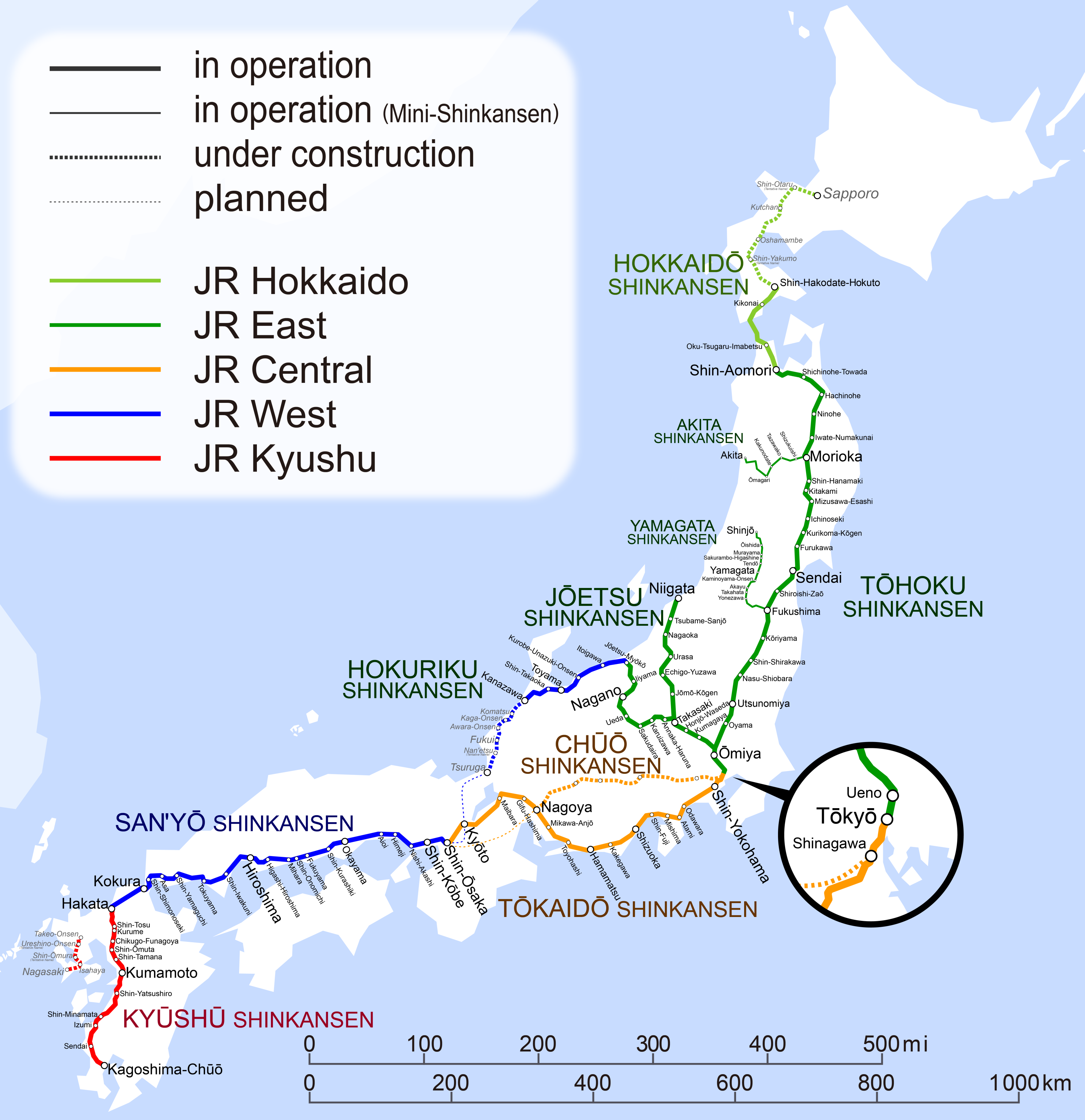
Going south of Tokyo, the off-peak frequency to Shin-Osaka is four express Nozomi trains an hour, at :00, :09, :30, :51 off-peak; two semi-express Hikari, at :03, :33; and one local Kodama, at :57. The 21-minute gaps are ugly, but on a train that takes around 2.5 hours to get to Shin-Osaka, they’re not too onerous. Thus, there is a culture of going to the train station without pre-booking a ticket and just getting on the next Nozomi. The ticketing system reinforces this: there is no dynamic yield management, but instead fixed ticket prices between pairs of station depending on seat class. What yield management there is is static: the Nozomi has a small surcharge, to justify excluding it from the JR Rail Pass and so shunt tourists to the Hikari.
This is not literally the headway-management system seen on some unbranched subway systems, like the Moscow Metro and Paris Métro; Moscow keeps time by distance from the preceding train, and not by a fixed schedule. But this is fine: some subway systems are timetabled, like the U-Bahn in Berlin and the Tokyo subway. Tokyo even manages to mix local and express trains on some two-track subway lines with timed overtakes. To the scheduler, the fixed timetable is of paramount importance. But to the passenger, it isn’t – people don’t time themselves to a specific train.
Another subway-like characteristic includes interior layout, designed around fast egress. Shinkansen cars have two door pairs each and platforms are 1,250 mm high with level boarding, enabling 1 minute dwell times even at very busy stations like Shin-Osaka. Trains make multiple stops in the Tokyo and Osaka regions, and even Nozomi and equivalent fastest-train classes on other lines stop there, to distribute loads. There is no cafe car, and luggage is overhead, to maximize train seating space: a 25 meter car has 18-20 seating rows with 1-meter pitch, which is greater efficiency than is typical in Europe.
Station location decisions, finally, are designed as far as practical to be in city centers. Stations with Shin- before their names are new stations, like Shin-Osaka and Shin-Yokohama, but they tend to be sited close to city centers, at intersections with subway and commuter rail lines.
The main drawback of Japan is that the construction costs are very high. This comes from a political decision to build elevated lines rather than at-grade liens with earthworks, as is common in Europe. This preponderance of els has been exported to South Korea, Taiwan, and China, all of which have high costs relative to the tunneling proportion; the KTX, essentially a Shinkansen adapted to an environment in which the legacy trains are standard-gauge too, is notable for having low tunneling costs, as is common in Korea, but high costs on lines with moderate amounts of tunneling thanks to the high share of construction on bridges.
East Asia has high population density, which lets it get away with high costs since the ridership is high enough to compensate – THSR is at this point returning around 4% on very high costs. But in any other environment, this leads to severe problems. China, with lower incomes and fares than in Japan, Korea, and Taiwan, already has trouble paying interest on lines other than the Beijing-Shanghai system. India, building a turnkey Shinkansen as recommended by Japanese consultants, who were burned by Taiwan’s mix of European and Japanese technology on an operationally-Japanese system, is spending enormous sums of money: the Mumbai-Ahmedabad corridor is around PPP$50.6 billion, for 508 km, $100 million/km on a line that’s only 5% in tunnel and even those tunnels could have been avoided by running on broad gauge and using existing a widened legacy right-of-way in Mumbai.
The TGV as flight-level zero air travel
As detailed in New Departures by Anthony Perl, the history of the TGV differs from that of the Shinkansen in a key aspect: the TGV was built after the postwar decline of rail travel (as was the ICE), whereas the Shinkansen was built before it (as was to some extent CRH). The Shinkansen was built in 1959-64: there was no decline in rail evident yet, with only 12 cars/1,000 people in Tokyo in 1960, and the system was designed to deal with growing ridership. In contrast, the TGV was planned after the 1973 oil crisis, in a then-wealthier and more motorized country than Japan, aiming to woo passengers back to the train from the car and the plane.
Previously, SNCF had been engaging in experiments with high speed and high-voltage electrification, inventing 25 kV 50 Hz electrification in the process, which would be adopted by the Shinkansen and become the global standard for new electrification. It also experimented with running quickly on ballasted track – without modifications, the trains of that era kicked ballast up at high speed, there was so much air resistance. But investment had gone to legacy intercity rail, driving up the average speed of the electrified Mistral to 130 km/h and the Aquitaine to 145 km/h. Nonetheless, competition with air was fierce and air shuttles in that era before security theater attracted many people in competition with four-hour trains from Paris to Lyon and Bordeaux.
The TGV’s real origin is then 1973. The crisis shocked the entire non-oil-exporting world, leading to permanently reduced growth not just in rich countries (by then including Japan) but also non-oil-exporting developing countries, setting up the sequence of slow growth under import substitution and then the transition to neoliberalism. France reacted to the crisis with the slogan “in France, we have ideas,” setting up the nuclearization of French electricity in the 1980s, reduced taxes on diesel to encourage what was then viewed as surplus fuel rather than as a deadly pollutant, and the construction of the electric TGV.
Despite the ongoing growth of the Shinkansen then, there was extensive skepticism of the TGV in the 1970s and early 80s. The state refused to finance it, requiring SNCF to borrow on international markets. The LGV Sud-Est employed cost-cutting techniques including 3.5% grades and high superelevation to avoid tunnels, at-grade construction with cut and fill balancing out to avoid surplus dirt, and land swaps for farms that would be split by the line to avoid needing to build passageways.
Construction costs were only 5.5M€/km in 2021 euros. Unfortunately, costs have risen since and stand at 20M€/km, or even higher on Bordeaux-Toulouse. But the LGV network remains among the least tunneled in the world thanks to the use of high grades; in our database the only less tunneled network, that of Morocco, is a turnkey TGV, built at unusually low cost.
As in Japan, the line was built between the two largest cities: Paris and Lyon. Also as in Japan, Lyon could not be served at the historic center of Perrache, but instead at a near-center location, Part-Dieu, which then became the new central business district, as the LGV Sud-Est was built concurrently with the Lyon Metro and nearby skyscrapers, as is typical for a European city wishing to avoid skyscrapers in historic centers. But everything else was different. There were no real intermediate stops the way that the express Shinkansen have always stopped at Nagoya and Kyoto: the LGV Sud-Est skipped Dijon, which instead was served on a branch, and the two intermediate stops on the line, Le Creusot and Mâcon-Loché, are on the outskirts of minor towns and only see a few trains per day each.
Moreover, relying on France’s use of standard-gauge, there was, from the start, extensive through-service beyond Lyon, toward Marseille, Geneva, Saint-Etienne, and Grenoble. Frequency was for the most part low, measured in trains per day. There was little investment in regional rail outside the capital, unlike in Germany, and therefore there was never any attempt to time the connections from Saint-Etienne and Grenoble to the TGV at Part-Dieu.
At the other end, Paris did not build a central station, unlike German or Japanese cities. The time for such a station was, frustratingly, just a few years before work began on the TGV in earnest: RATP was building the RER starting in the 1960s and early 70s, including a central station at Les Halles, which opened 1977. But this was designed purely for urban and suburban use, and the TGV stayed on the surface. The last opportunity for a Paris central station was gone when SNCF extended the RER D from Gare de Lyon to Les Halles. Thus Paris has four distinct TGV stations – Lyon, Montparnasse, Nord, and Est – with poor connections between them.
This turned the TGV into a point-to-point system. Were there a central station, trains could have gone Lille-Paris-Lyon-Marseille. But there wasn’t, and so for Lille-Lyon service, SNCF built the Interconnexion Est, bypassing Paris and also serving Disneyland and Charles-de-Gaulle Airport. When the LGV Atlantique opened, Tours kept its historic terminal, and thus trains went either Paris-Tours or Paris-Bordeaux bypassing Tours. When the LGV Sud-Est was extended south with the LGVs Rhône-Alpes and Méditerranée, trains did not go via Part-Dieu, even though it had always been configured as a through-station for points south, but rather via a bypass serving Lyon’s airport; trains today go Paris-Lyon, Paris-Marseille, or at lower frequency Lyon-Marseille, but not Paris-Lyon-Marseille.
Of note, Japan’s subway-like characteristic is partly the outcome of its linear geography along the Taiheiyo Belt, making it an ideal comparison also for the Northeast Corridor in the United States. But Lille, Paris, Lyon, and Marseille are collinear, and yet the service plans do not make use of that geography. There is no planning around seat turnover: if a train makes an intermediate stop, it’s one with very low ridership, like Mâcon, with no attempt to have seats occupied by Paris-Lyon passengers and then by Lyon-Marseille ones.
Over time, this led to a creeping airline-ization of the TGV. Airline-style dynamic yield management was introduced, I believe in the 1990s. This was after SNCF had spent the 1980s marketing the TGV as 260 km/h for the same fare as 160 km/h; the overall fares on legacy intercity trains and TGVs are similar per p-km, but TGVs have opaque pricing, and are designed to maximize fares out of Paris-Lyon in particular, where air competition vanished. The executives at SNCF are increasingly drawn from the airline world, and, perhaps out of social memory of the navettes competing with 4-hour trains in the 1970s, they think that trains cannot compete with air travel if they take longer than 3-3.5 hours, even though they do successfully on such city pairs as Paris-Toulon.
Having skipped Germany’s InterCity revolution and its refinements in Switzerland, Austria, and the Netherlands, the TGV network has stagnated in the last decade. Ridership is up since the pre-Great Recession peak but barely, only by around 10%. The frequency is too weak for inter-provincial links, where people mostly drive, and in the 1990s and 2000s the TGV network grew to dominate the Paris-province market; there isn’t much of a remaining market for the current operating paradigm to grow into.
While some regional links are adopting takt timetables, for example some of the Provence TERs, SNCF management has done no such thing. Instead, it has spent the last 15 years pursuing airline strategies, including imitation of low-cost airlines, first iDTGV and then OuiGo. A generalist elites of business analysts believes in market segmentation and price discrimination, which do not work on a mode of travel where a frequent, flexible timetable is so paramount.
Among the countries influenced by France, Spain is notable for realizing that it has a problem with operations. In an interview with Roger Senserrich, ADIF head Isabel Pardo de Vera spoke positively of Spain’s efficient engineering and construction, but centered ADIF and RENFE’s problems, including the poor operations. Like Italy and Belgium, and more recently Morocco, Spain learned the concept of high-speed rail from France; also like Italy and Belgium, it mixed in a few German elements, which in the 1980s meant Germany’s more advanced LZB signaling, but at the time, there was no Switzerland-wide takt yet, and the inferiority of French operations and scheduling was not yet evident. But Spain self-flagellates – this is how it learns – whereas France is just a hair too rich to recognize its weaknesses and far too proud for its elite to Germanize where needed.
The ICE as long-distance regional rail
Germany came into the 1960s with some of the most advanced legacy rail in the world, with technology that would be adopted as a Shinkansen standard. This goes back to the 1920s, when Deutsche Reichsbahn was formed from the merger of the state-level railways in the wake of the post-WW1 German Revolution. The new railway regulation, dating to 1925, promoted new kinds of engineering now completely standard, such as the tangential switch. DRB would also experiment with 200 km/h diesel express trains in the 1930s. Even in the 1960s and early 70s, when the most advanced rail tech was clearly in Japan, Deutsche Bundesbahn kept up with rail tech, much like SNCF, inventing LZB signals.
But unlike Japan and France, Germany never built a complete high-speed rail network. The InterCity network, dating to 1971, was designed around fast legacy trains, at slightly lower speeds than available on the express French legacy trains. The key was that city pairs would be served every two hours, with timed connections at intermediate points boosting many to hourly. This was from the start based on a regular takt and turnover, with more expansive service to smaller cities.
High-speed lines in Germany were delayed, and often built on weird alignments. The most important reason is that in the formative period, from 1971 to 1990, there was no such country as Germany. The country was called West Germany, and, much like Japan, had a fairly linear population distribution from the Ruhr upriver to Cologne, Frankfurt, Mannheim, and finally either Karlsruhe or Stuttgart and Munich; but the largest city proper, Hamburg, lay outside this corridor.
The north-south orientation of West Germany contrasted with the rail network it inherited. Until the post-WW1 German Revolution, the rail networks were run by the states, not by the German Empire, and thus interstate connections were underbuilt. Prussia had an east-west orientation, and therefore north-south lines were relatively underbuilt (see for example the 1896 map), and to top it off most north-south routes crossed the Iron Curtain.
To solve many problems at once, but not to solve any of them well, Germany’s first high-speed line connected Hanover, Göttingen, Kassel, Fulda, and Würzburg. Getting to more substantial cities like Hamburg and Frankfurt requires onward through-service at lower speed. The LGV Sud-Est had a minimum curve radius of 3.2 km, and usually 4 km, and can squeeze 300 km/h out of it now, without any tunnels; the Hanover-Würzburg line has a minimum radius of 5.1 km and a maximum grade of 1.25% and is limited to 280 km/h (service runs at 250 km/h), as it was built as a mixed freight-passenger line.
Subsequent lines have, like Hanover-Würzburg, not been complete connections between major cities. Here the difference with France, Italy, South Korea, and China is evident. All are standard-gauge countries, like Germany, and all employ through-service to various degrees. But France opened a complete Paris-Lyon high-speed line in 1981-3, and only the last 30 km into Paris were on legacy trains (since reduced to 8 km with the Interconnexion Est), and likewise Italian, Chinese, and Korean high-speed lines connect major cities all the way. In contrast, this never happens in Germany at longer distance than Cologne-Frankfurt, a 180 km connection. There are always low- or medium-speed segments in between. The maximum average speed between major cities in Germany is either Cologne-Frankfurt or Berlin-Hamburg, a 230 km/h line with tilting trains, both averaging around 180 km/h; the Tokaido Shinkansen, with legacy 2.5 km curves, squeezes 210 km/h out of the Nozomi, and LGVs routinely average 230-250 km/h between Paris and major secondary cities.
Nor are the lower speeds in Germany saving money. The mixed passenger/freight lines have heavier tunneling than they would need if they had 3.5-4% grades. Hanover-Würzburg cost 36M€/km in 2021 euros thanks to its 37% tunneled alignment. German construction costs are not high relative to the tunneling percentage, unlike Chinese or Taiwanese costs, let alone British ones, but the tunneling percentage is in many cases unnecessarily high. This is thankfully not exported to every Northern European country that learned from the InterCity, but the Netherlands, as NIMBY-ridden as Germany, built an unnecessary tunnel on the HSL Zuid and had very high costs even taking that into account; Italy, with an otherwise-French system, likewise overbuilds, as pointed out by Beria-Albalate-Grimaldi-Bel, with viaducts designed to carry heavy freight trains even where there is no such demand.
So the bad in Germany is that the lines have very shallow grades, forcing heavy tunneling, and the costs are so high that the system is not complete. Is there good? Yes!
The InterCity system’s focus on high frequency enables decent service between major cities. Berlin-Munich trains, compromised by the Erfurt detour and subsequent descoping of much of the line, do the trip in 4.5 hours where they should be taking 3 and even 2.5 hours. But it’s not the same as the 4 hours of the pre-TGV Mistral to Lyon or Aquitaine to Bordeaux, the latter of which averaged the same speed as most Berlin-Munich trains today. The Aquitaine ran as a single daily Bordeaux-Paris-Bordeaux round-trip, and another train, branded the Etendard, ran the same route daily but Paris-Bordeaux-Paris. In contrast, DB today connects Berlin-Munich roughly every hour. It’s far more flexible, and the connections to other intercity trains are better.
And just as the TGV’s inexpensive construction has been perfected in Spain while France has slouched on cost control, so has the interconnected system of Germany been perfected on the margins of its sphere of influence, especially in Switzerland. Swiss connections are never fast: the country is too small for 300 km/h trains to make large differences in door-to-door trip times. The average speed on the workhorse Swiss lines connecting the Zurich-Bern-Basel triangle is around 110-120 km/h. But they run on a half-hourly takt, and other lines run on an hourly takt, and connections at the major cities are timed. European urbanism has a long tail of small cities, unlike American or Asian urbanism, and the Swiss takt connections those small cities to one another through regular timed transfers, with investments to prioritize punctuality.
This leads to a false belief among German rail advocates in a tradeoff between French or Spanish speed and Swiss or Dutch or Austrian connectivity. The latter set of countries have higher rail ridership per capita, and even Germany has recently overtaken France’s intercity rail ridership (though not yet per capita), and thus activists in Germany think investing in high speed is a waste. But what is actually happening is that the countries of Europe that look up to France have built high-speed rail, and the countries that look down on France have not; the Netherlands has HSL Zuid but it’s peripheral to the national network and its system is otherwise rather Swiss. Germany absolutely can and should complete its network. It just needs to understand that in certain aspects, countries it is used to stereotyping as spendthrift have done a more prudent job than it has.
Already, the younger rail advocates I meet, like Felix Thoma, seem interesting in applying the Deutschlandtakt concept to a high-speed rail network, rather than to a medium-speed one as the previous generations called for. But Germany is a NIMBY country. NIMBYs blocked French levels of energy nuclearization in the 1970s and 80s, creating the last generation’s Green Party (current leader, Annalena Baerbock, is 40 and came of age after those fights); NIMBYs sue projects they dislike on frivolous grounds until the politicians lose interest, much as in the US with its government-by-lawsuit, and thus high-speed rail on the Hamburg-Hanover line has been stuck in limbo for a generation.
Besides the political deference to NIMBYs, who as in the US are not as powerful as either they or the state thinks, the main problem then is unwillingness to merge French and German planning insights where they work. I might also add Japanese insights – the Shinkansen is far more efficient with platforms than any European railroad – but they’re less important here or in France than in the UK, which is a ridiculously high-cost version of French planning.
China as a mixture of all modes, some good, some awful
When I started planning this video and now post, I was puzzling over where to slot China. Other systems seemed fairly easy to slot as Japanese, German, or French, with the occasional special feature (insanely high UK costs, HSL Zuid in an otherwise Swiss intercity takt system, Korean standard-gauge adaptations). But China is its own thing. It makes sense: on the eve of corona, China had 2.3 billion annual high-speed rail riders, comfortably more than than the rest of the world put together; Japan, the second busiest network, had 436 million. In Europe, only France has more high-speed rail ridership per capita, by the smallest of margins.
Historically, the system should be viewed as having borrowed liberally from other systems in richer countries that built out their networks earlier. Among the three prior traditions, the one most similar to what CRH has converged on is the Shinkansen, and yet there is significant enough divergence I would not class CRH as a direct Shinkansen influence the way I do the KTX and THSR. This also mirrors the situation for rapid transit: China displays clear Soviet influences but has diverged sufficiently that it must be viewed as a separate tradition now.
The most important feature is that CRH evolved on the cusp of the decline of rail in favor of cars and planes, a decline that has been more complete in Western countries. In the 1980s and early 90s, China was already growing very quickly; this was from a very low base, so it was not noticed in richer countries, but it was enough that there were already motorization and domestic air travel competing with China Railway. This led to a multi-phase speed-up campaign, announced in 1993 and implemented from 1997 to 2007.
At this point, construction was on legacy alignments to legacy stations. In the North China Plain, the railroads were straight thanks to the flat topography, and so what was needed was investment in the quality of the physical plant – the sort of investments figured out in midcentury France and Germany, adapted by the Shinkansen. This was not trivial, not in a then-low-income country like China, but it was not enormously expensive either. At the same time, there was growing electrification in China, using 25 kV 50 Hz, leading to higher and higher train classes, all charging premium fares over the third-world tickets for traditional trains. At the apex was the D class, covering 200 km/h EMUs; the one time I rode a train in China, a day trip from Shanghai to Jiaxing and back in 2009, the way back was on a D class train, which had the comfort level and speed of the Northeast Corridor, topping at 170 km/h and averaging maybe 110. This investment has continued, and as of 2019, 72% of the network is electrified.
But China was already looking for more. In 2008, the Beijing-Tianjin high-speed line opened, as the world’s first 350 km/h line. In the financial crisis’s aftermath, China rapidly built out the network as fiscal stimulus, and by 2011, ridership overtook the Shinkansen’s as the world’s largest. Without legacy considerations, the system is built for 380 km/h, even though trains run at 350 km/h, and express trains average 280-290 km/h.
Like the United States and unlike Japan or most of Western Europe, China has an extensive freight rail network. Its approach is the opposite of Germany’s: high-speed lines are dedicated to passengers, and some are officially called passenger-dedicated lines, or PDLs, to make this clear. Freight trains go on the legacy network. Regional rail in China is very weak; the few lines that exist are new-builds, rather like long-range subways, and frequency is often lacking, the Beijing lines branded as S-Bahn barely running off-peak. With nearly all intercity rail having moved over to CRH, the legacy network is relatively free for freight use, even coal trains, which are slow and care little for reliability improvements for higher-end intermodal cargo.
However, the passenger-only characteristic of CRH’s system does not mean it’s employed French cost-cutting techniques. Rather, lines run almost exclusively on viaducts and have shallow grades, raising construction costs as in the rest of East Asia. Stations are newly-built at high expense: Beijing South cost 7 billion yuan, which in today’s PPP dollars is around $3 billion. There are many tracks and no economization with fast turnarounds as in Japan, and station layouts are comparable to airports, with some security theater.
Beijing South is at least just outside the Second Ring Road. Other stations are farther out. This is not just the beet field stations that characterize TGV service to small cities like Amiens or Metz, but also outlying stations in major centers. Shanghai Station only sees high-speed trains on the local line to Nanjing, providing a dedicated track pair equivalent to Kodama service while Nozomi-equivalent trains continue on to Beijing on their own tracks. The trains to Beijing get a separate Shanghai station, Hongqiao, colocated with the city’s domestic airport. The connecting subways tend to be better than at true beet field stations in France, which miss regional rail connections, but those stations are still well outside city center.
China is moreover exporting the bad more than the good. Chinese-funded projects in Africa are not fast – the average speeds are perhaps midway through China’s speed-up campaign, predating CRH. But they do have oversize, airport-like stations located well outside city centers. This happens even when right-of-way to enter city center exists, as in Nairobi.
On mixing and matching
Understanding these four distinct traditions is important for high-speed rail planning, in those four countries as well as elsewhere, such as in the UK and US. It’s important to understand the tradeoffs that these traditions made, and drawbacks that are not so much tradeoffs as things that didn’t seem important at the time.
Most notably, Britain has oversize stations, spending billions on new terminals such as in Birmingham. This comes from the low efficiency of most European turnaround operations, because most European cities have huge rail terminals from the steam era with a surplus of tracks. When trains need to turn fast, they do: German trains running through Frankfurt, which is a terminal, turn in 3-4 minutes to continue to their onward destination. In Tokyo, where space is at a premium, JR East learned to turn trains in 12 minutes even while giving them a cleaning, and with such tight operations, Britain should be able to fit traffic growth within existing station footprints.
It is also desirable to learn from students who have surpassed their old teachers. Korea has lower construction costs than Japan, Spain has lower construction costs than France and greater understanding of the need to integrate the timetable and infrastructure, Switzerland has perfected the German system to the point that German rail advocacy calls for reimportation of its planning maxims.
In the same way that Taiwan built infrastructure to European specs but is running Japanese trains on it, to its profit and to Japan’s chagrin, it may be advisable to build infrastructure in the French (or, better yet, Spanish) way but then run trains on it the German (or better yet, Swiss) way. But it’s more nuanced than this conclusion, due to important contributions from China and Japan, and due to the focus on having a central station, which France chose not to build in Paris to its detriment.
But in general, I think it behooves countries to learn to implement the following from those four traditions:
- Japan: the best rolling stock, high-efficiency turnaround operations, reliable schedules; avoid excessive viaducts and Japan’s increasing demand for turnkey systems.
- France: passenger-dedicated infrastructure standards (supplemented by Cologne-Frankfurt), land swap deals for at-grade construction, cost control (in the Spanish version – France is deteriorating); avoid TGV rolling stock and airline-style pricing.
- Germany: takt (especially in the Swiss and Dutch versions), open station platforms, integration between timetable and infrastructure, seat turnover, decent rolling stock; avoid empowering NIMBYs and building mixed lines with freight.
- China: separation of passenger and freight operations, very high average speeds; avoid airline-style outlying stations and excessive viaducts.
