The Yamanote Line: a Ring or a Radial?
Note: I am going to take some suggestions for post topics in the future. This post comes from a Twitter poll I ran the day before yesterday.
The Yamanote Line in Tokyo is a ring. Trains go around the ring as on any other circular rail line. However, the line is not truly circumferential, since it serves as a north-south trunk through Central Tokyo. In that way, it contrasts with fully circumferential rings, such as the Moscow Circle Line, Seoul Metro Line 2 (see update below), and the under-construction Paris Metro Line 15. It’s really a hybrid of radial and circumferential transit, despite the on-paper circular layout. In previous posts I’ve attacked one kind of mixed line and given criteria for when another kind of mixed line can work. In this post, I’m going to discuss the kind of mixed line Yamanote is: why it works, and in what circumstances other cities can replicate it.
Consider the following diagram:
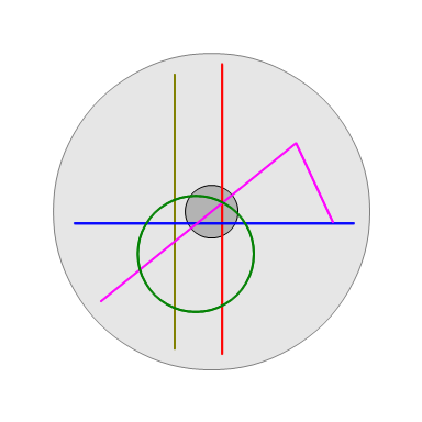
The red and blue lines are radial. The other three are hybrids. The yellow line is radial, mostly, but skirts city center and acts as a circumferential to its west; this kind of hybrid is nearly always a bad idea. The pink line is radial, but at the eastern end bends to act as a circumferential at the eastern end; this kind of hybrid is uncommon but can work in special cases, for example if Second Avenue Subway in New York is extended west under 125th Street. The green line is a Yamanote-style ring, offering radial service through city center but also circumferential service to the south and west.
On this map, the green line ensures there is circumferential service connecting what are hopefully the major nodes just west and south of city center. It doesn’t do anything for areas north and east of it. This means that this line works better if there is inherently more demand to the west and south than to the east and north. In Tokyo, this is indeed the case: the Yamanote ring offers north-south circumferential service west of Central Tokyo, through what are now the high-density secondary business districts of Ikebukuro, Shinjuku, and Shibuya. East of Central Tokyo, the only really compelling destinations, judging by subway ridership, are Oshiage and Asakusa, and neither is as big as Ikebukuro, Shinjuku, or Shibuya. Toyosu has high subway ridership, but is close enough to the water that it’s hard to build a circumferential through it.
Such a mixed line also becomes more useful if the radial component is better. The radial line can’t extend very far out, since the line needs to form a ring, so it should connect to very high-density neighborhoods just a few stops outside city center, or else provide additional service on an overloaded radial trunk. The Yamanote Line benefits from looking less like a perfect circle and more like upside-down egg, with two elongated north-south legs and two short (one very short) east-west legs; it extends its radial segment slightly farther out than it would otherwise be. In Tokyo, of course, all rail lines serving the center are beyond capacity, so the Yamanote Line’s extra two tracks certainly help; in fact, the two radial lines going north and south of Tokyo Station on parallel tracks, the Tohoku and Tokaido Lines, are two of the three most overcrowded in the city. (The third is the Chuo Line.) There’s even a dedicated local line, Keihin-Tohoku, covering the inner segments of both lines, making the same stops as Yamanote where they are parallel, in addition to the more express, longer-distance Tokaido and Tohoku Main Line trains.
Finally, there should not be radials that miss the mixed line; this is always a danger with subway lines that are neither pure radials nor pure circumferentials. Yamanote avoids this problem because it’s so close to the water at Shimbashi that the north-south subway lines all curve to the west as they go south, intersecting the ring. It’s actually the east-west lines that cross the Yamanote Line without transfers, like Tozai and Hanzomon; the north-south lines intersect the line with transfers.
The obvious caveat here is that while the Yamanote Line functions very well today, historically it did not originate as a circumferential in an area that needed extra service. It was built as a bypass around Central Tokyo, connecting the Tokaido and Tohoku Line at a time when Tokaido still terminated at Shimbashi and Tohoku at Ueno. Tokyo Station only opened 30 years later, and the ring was only completed another 10 years after that. Shinjuku only grew in the first place as the junction between the Yamanote and Chuo Lines, and Ikebukuro and Shibuya grew as the terminals of interwar private suburban railways. When the line opened, in 1885, Tokyo had 1.1 million people; today, the city proper has 9.5 million and the metro area has 38 million. The early rail lines shaped the city as much as it shaped them.
Nonetheless, with the economic geography of Tokyo today, the Yamanote Line works. Even though the history is different, it’s a useful tool for mature cities seeking to build up their rail networks. Provided the principles that make for the Yamanote Line’s success apply – stronger demand for circumferential service on one side of city center than on the others, demand for supplemental inner radial service, and good connections to other lines – this layout can succeed elsewhere.
Waterfront cities should take especial note, since they naturally have one side that potentially has high travel demand and one side that has fish. In those cities, there may be value in running the radial closest to the shoreline in a ring with an inland line.
This does not mean that every waterfront city should consider such a line. On the contrary: non-examples outnumber examples.
In Toronto, using two mainline tracks and connecting them to a ring to provide subway relief could have worked, but there are no good north-south corridors for such a ring (especially on the west), and the only good east-west corridor is Eglinton, which is being built incompatible with mainline rail (and has too much independent value to be closed down and replaced with a mainline link).
In Chicago, the grid makes it hard to branch lines properly: for example, a ring leaving the Red Line heading west at Belmont would necessary have to branch before Belmont Station, cutting frequency to the busiest station in the area. Plans for a circle line from last decade also faced limited demand along individual segments, such as the north-south segment of the Pink Line parallel to Ashland; ultimately, the planned line had too small a radius, with a circumference of 16 km, compared with 34.5 for Yamanote.
In Tel Aviv, there just isn’t any compelling north-south corridor outside the center. There are some strong destinations just east of Ayalon, like the Diamond Exchange and HaTikva, but those are already served by mainline rail. Beyond that, the next batch of strong destinations, just past Highway 4, is so far from Central Tel Aviv that the line would really be two radials connected by a short circumferential, more the London Circle Line when it was a full circle than the Yamanote Line, which is just one radial.
So where would a Yamanote-style circle be useful outside Tokyo? There are semi-plausible examples in New York and Boston.
In New York, it’s at the very least plausible to cut the G off the South Brooklyn Line, and have it enter Manhattan via the Rutgers Street Tunnel, as a branch of the F, replacing the current M train. There is no track connection enabling such service, but it could be constructed just west of Hoyt-Schermerhorn; consult Vanshnookraggen’s new track map. This new G still shouldn’t form a perfect circle (there’s far too much radial demand along the Queens Boulevard Line), but there are plausible arguments why it should, with a short tunnel just west of Court Square: namely, it would provide a faster way into Midtown from Williamsburg and Greenpoint than the overcrowded L.
In Boston, there is a circumferential alignment, from Harvard to JFK-UMass via Brookline, that can get a subway, in what was called the Urban Ring project before it was downgraded to buses. Two of the busiest buses in the region, the 1 and 66, go along or near the route. An extension from Harvard east into Sullivan and Charlestown is pretty straightforward, too. Beyond Charlestown, there are three options, all with costs and benefits: keep the line a semicricle, complete the circle via East Boston and the airport, and complete the circle via the North End and Aquarium. The second option is a pure circumferential, in which South Boston, lying between East Boston and JFK-UMass, would get better service north and south than west to Downtown. The third option cuts off East Boston, the lowest-ridership of the radial legs of the subway, and offers a way into the center from South Boston and Charlestown.
Of note, neither New York nor Boston is a clear example of good use of the Yamanote-style ring. This style of mixed line is rare, depending on the existence of unusually strong circumferential demand on just one side (west in Boston, east in New York), and on the water making it hard to build regular circles. It’s an edge case; but good transit planning revolves around understanding when a city’s circumstances produce an edge case, in which the simplest principles of transit planning (“every subway line should be radial or circumferential”) do not apply.
Update 5/16: commenter Threestationsquare reminds me that Seoul Metro Line 2 is the same kind of ring as Yamanote. The north leg passes through City Hall, near the northern end of the Seoul CBD, providing radial east-west service. The south leg serves a busy secondary commercial core in Gangnam, Tehran Avenue; Gangnam Station itself is the busiest in Seoul, and has sprouted a large secondary CBD.
 Pedestrian Observations

