Category: New York
Subway Expansion to Kingsborough Community College
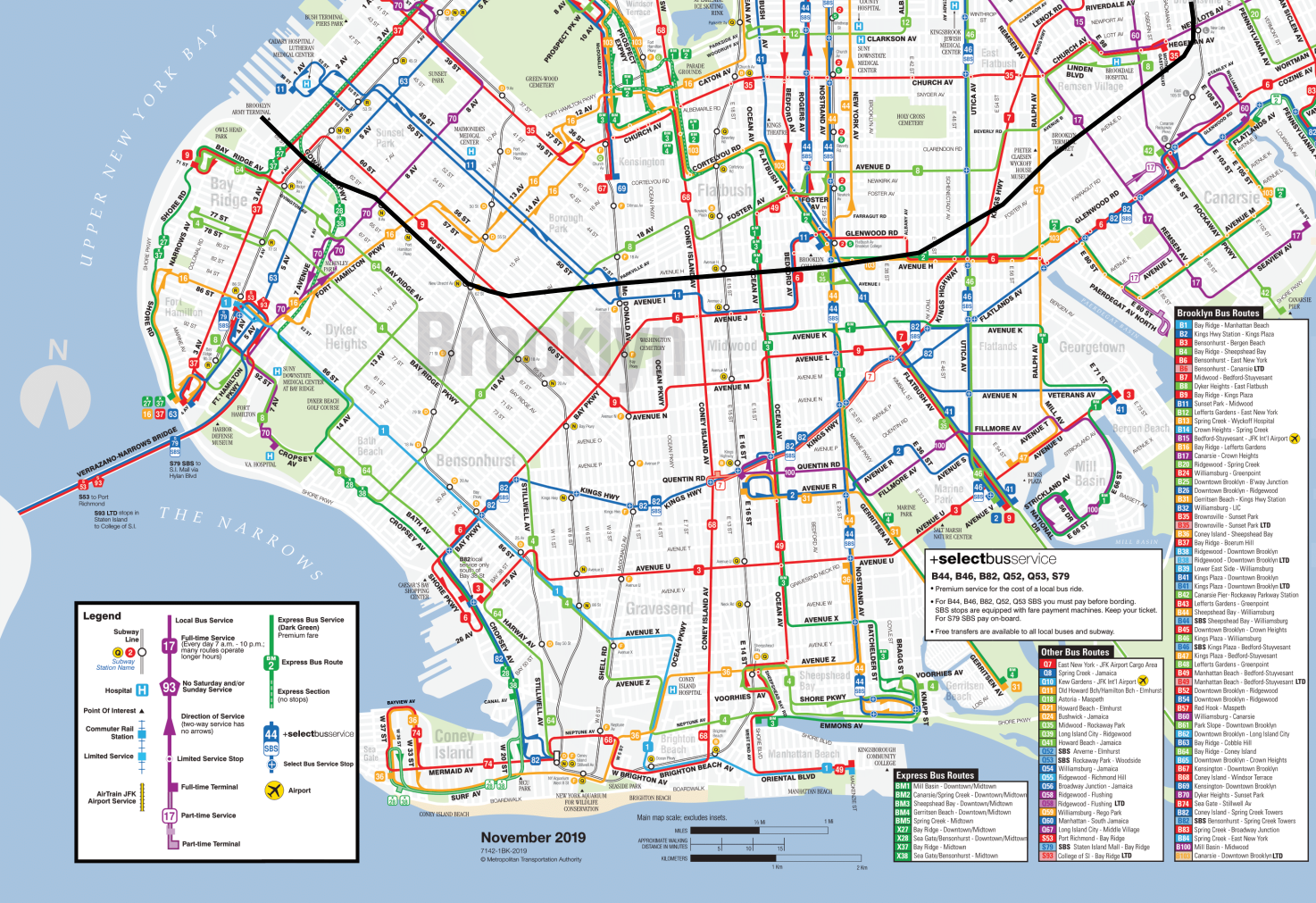
One of the perennial wishlist items for New York subway expansion is Nostrand Avenue. The 2 and 5 trains run under the avenue between Eastern Parkway and Brooklyn College, a distance of 4 km; from the start, the line was intended to be extended farther south, and in both the 1950s and 1970, there were plans for such extension as well as one shortly to the east under Utica, to be built right after Second Avenue Subway. The case for Nostrand and Utica remains strong – these two streets host Brooklyn’s two busiest buses (the B44 and B46 respectively), and another top route, the B41 on Flatbush, is closely parallel. The purpose of this post is to ask what the southern end of Nostrand should be, and whether a longer extension going to Kingsborough Community College is a good idea.
Nostrand: current plans
All plans I am aware of for extending the subway under Nostrand have it following the street to Sheepshead Bay. For example, my proposal from 2019 would terminate it right at the water, at Emmons Avenue, where the B44’s southern end is. This reflects official proposals over the last few generations: a Nostrand subway is to run just under Nostrand.
Kingsborough Community College
Right across geographic Sheepshead Bay from the neighborhood named after the bay, the eastern end of geographic Coney Island comprises the neighborhood of Manhattan Beach. It is not a dense area, and for the use of residents, there are buses to the Brighton Beach subway station. However, at the easternmost end of Manhattan Beach, Kingsborough Community College (KBCC) is a huge destination.
How huge? The bus serving it, the B1, is one of the busiest in Brooklyn, with some rush hour runs just operating back and forth as short-hop shuttles between Brighton Beach and KBCC, a distance of 2 km. Frequency at rush hour reached a bus every 3-4 minutes before corona.
This is not easily legible to commuter-oriented planning tools like OnTheMap. That area has only 1,000 jobs; KBCC itself doesn’t generate many jobs, nor does it anchor other industries around it that aim to employ graduates. Those planning tools can capture other universities if they’re more residential and higher-end – those have a higher ratio of faculty to students, have ample research labs, and anchor employers who look to locate near residential students. In contrast, a commuter college is largely invisible to them. In reality, there are 18,000 students, all of whom commute from elsewhere.
How much ridership does this generate?
KBCC has 18,000 students, and the overall area has 1,000 workers. If the modal split were 100%, this should generate 38,000 trips per weekday; commuter colleges don’t generate as many non-commute trips as do residential colleges. In reality, the modal split is not 100%, but it should be high given the low car ownership rates in the city, especially low for college students.
The bigger question is what proportion of the travel market would ride a Nostrand subway in preference to a rail-bus connection at Brighton Beach. This in turn depends on the state of the rest of the system. If the Interborough Express or some variant of it is already built, then from all points on or north of the IBX route, an all-rail route is superior to a rail-bus connection. If it isn’t, then it’s dicier, and from much of Southern Brooklyn from the Brighton Line to the west, the B1 is likely faster.
IBX should be built ahead of such a connection based on current plans, so the assumption should be the more optimistic one – and, of course, if there is long-term planning for subway extensions, then this should figure as an argument in favor of IBX. KBCC is hardly the only place that, despite being far from IBX, IBX can help riders access. In that scenario, 30,000 trips a day are not unrealistic, and 20,000 should be conservative.
How much should this cost?
I do not know. In an unusual inversion, I’m more confident of the benefits than the costs. The travel market is fairly circumscribed. In contrast, the costs have a question mark, because of the premium coming from underwater construction.
With no premium at all, New York should be able to reduce its construction costs for subways to $200 million per km on average, and less on easy sections, that is, on outer extensions of the system in the Outer Boroughs. But Nostrand has a high water table, and the underwater segment across Sheepshead Bay is not easy; figure $250-300 million per km, with a wide error margin.
This is not an onerous cost. It’s about 600-700 meters longer than the usual plan for Nostrand to Emmons, and presumably the whole route would be built at once with a tunnel boring machine, so the fixed costs are already paid. So $200 million is probably a reasonable cost.
IBX Cannot be a Tram
Clay Guse of the NY Daily News reports that in New York, the plans for the Interborough Express connector between Brooklyn and Queens are starting to lean in the direction of light rail. To be very clear, light rail in this context just means running light rail vehicles on infrastructure that is entirely grade-separated, either in the Bay Ridge Branch right-of-way (which has a handful of freight trains and is mostly wide enough for light rail and freight on separate tracks) or on viaducts (over the sections of the branch that are too narrow). I do not think there is any plan to downgrade IBX to a tramway. However, on Twitter I was asked about this anyway: why not make it a tramway, for more on-street flexibility?
What is a tram? Or a streetcar? Or light rail?
A tram or streetcar is a rail vehicle that runs predominantly on-street. The quality of the right-of-way may vary, from full mixed traffic as was traditional, to dedicated lanes that may be shared with buses and emergency traffic, to a grassy median that is no longer usable by road vehicles. But the distinguishing feature of the streetcar is that it runs on a street.
The doesn’t mean the streetcar has to run on-street the entire way. Street running is slow, even with dedicated lanes. Paris’s T3, an orbital tram in the grassy median of the Boulevards des Maréchaux on the outer margin of the city, averages 18 km/h. Berlin’s streetcars average 19 km/h; a handful of central sections are mixed-traffic but most have dedicated lanes, and in outer parts of the city there’s just less traffic and lines are generally faster.
There are two main ways to speed up the streetcar: make it faster in city center via tunneling (called subway-surface, Stadtbahn, or premetro), or make it faster outside city center by finding grade-separated rights-of-way (called tram-trains). Confusing, both subway-surface and tram-train systems are called light rail in the US, and Germany’s most celebrated tram-train, that of Karlsruhe, is also called Stadtbahn. Because these systems have evolved from all-surface streetcars, the separation between them and streetcars is not always perfect, which is why the American distinction between light rail (either subway-surface or tram-train) and streetcar (all on-street) is sometimes muddied in popular reporting.
Can IBX function as a tram variant?
No.
The problem with running an orbital tram parallel to the right-of-way is that there is no good street for it to run on. On the map below, the thick black line denotes the right-of-way that IBX is to use:
There are no on-street alternatives to the right-of-way. Brooklyn has three major orbital buses: the B35 on Church, and the B6 and B82. Church is not wide – dedicated lanes there would be contentious and still produce inferior speeds to those of T3, let alone streetcars in less dense cities; it’s a great corridor for dedicated bus lanes, but not for a tram. The B6 and B82 shift between different streets, as do other crosstown routes, like the B1, B3, B8, B9, and B11. Even Kings Highway is only 24 meters wide.
This, in turn, is why IBX is such a great idea: it provides service that the surface bus networks can’t provide, because the quality of rights-of-way is poor unless one uses the Bay Ridge Branch. When the street network is poor, surface transit ridership is suppressed relative to travel demand, which means that a rapid transit service like IBX will overperform any model trained on existing travel volumes.
This is also why no variant with any street running is viable. Not only is there no good street for a streetcar, but also there is no section of a street that is good for a streetcar. The narrow sections of the Bay Ridge Branch right-of-way, mainly the segment between the F and Q trains, don’t parallel any convenient street.
Moreover, subway-surface alignments work by branching the grade-separated core into many surface branches, but there is no good tie-in. Circumferential lines sometimes do branch, but the best use case is when there are major destinations just off the route. This is not the case for IBX: Brooklyn College is on-route. The most significant destination in Brooklyn off the route is Kings County Hospital/SUNY Downstate, which is unusually poorly-served by the street network even by Brooklyn standards, and is therefore only on one bus route, the B12, rather than at the intersection of multiple buses as it ideally should be. There is no viable surface deviation off of the IBX right-of-way that serves it.
So why light rail?
The modal alternatives analysis seems biased in favor of light rail. This, to be clear, is not light rail as a service or infrastructure technology – the plan is to use viaducts wherever the Bay Ridge Branch right-of-way is too narrow for IBX and freight tracks side by side. Rather, the plan is to use light rail vehicles on a service that is entirely rapid transit.
This has precedent in the United States. In the same manner that historic streetcars evolved into subway-surface lines in Boston, Philadelphia, and San Francisco, and into the tram-trains that are called light rail elsewhere (with inspiration from Germany, brought in by American troops serving there in the Cold War), some light rail lines evolve into fully grade-separated rapid transit. It’s uncommon, because usually the parts that are left on the surface are the most difficult to construct, but it does exist. The Green Line in Los Angeles runs LRVs on a fully grade-separated right-of-way, mostly in the median of the 105, and the Gold Line’s initial section to and beyond Pasadena has just 1.5 km of street running, on Marmion Way. In Calgary and Dallas there are plans to bury light rail lines, which could result in fully grade-separated lines that still run LRVs and are locally conceived of as light rail.
But in New York, this is not a wise course of action. Running rapid transit with LRVs is great for a city that has LRVs but not subway trains, like the Los Angeles of the early 1990s. A city with both may potentially still elect to use LRVs if it expects some surface extensions. But New York has large-scale operations and maintenance for subway rolling stock, and none for LRVs. The only light rail in the region is in Jersey City and Newark, which do not share management or maintenance facilities with the city, and couldn’t do the latter even if they wanted to since they’re on the wrong side of the Hudson.
If intermediate-capacity transit is desired, New York could build shorter platforms, only long enough for 4- or 5-car trains. If even less capacity is desired, it could go down to 2-car platforms; the rolling stock would need to be somewhat captive to the line, since the rest of the system runs permanently coupled 4- and 5-car trains, but that’s completely normal for a large subway system, and heavy maintenance facilities can still be shared. I’m wary of reductions in capacity just for the sake of downsizing – this is an entirely above-ground project, so station costs are not as onerous as they are underground – but I can see a case for smaller trains.
I can’t find a good reason for this preference for light rail over subway equipment for what is, by infrastructure and service, rapid transit. I can find many bad ones, of which the most likely is a desire for something different from the subway with all the connotations it has.
But this does not mean that the IBX plan is a tram. It’s not; it’s rapid transit service, which could easily be a normal subway, running LRVs for bad reasons.
Deinterlining and Schedule Robustness
There’s an excellent Uday Schultz blog post (but I repeat myself) about subway scheduling in New York. He details some stunning incompetence, coming from the process used to schedule special service during maintenance (at this point, covering the entirety of the weekend period but also some of the weekday off-peak). Some of the schedules are physically impossible – trains are scheduled to overtake other trains on the same track, and at one point four trains are timetabled on the same track. Uday blames this on a combination of outdated software, low maintenance productivity, aggressive slowdowns near work zones, and an understaffed planning department.
Of these, the most important issue is maintenance productivity. Uday’s written about this issue in the past and it’s a big topic, of similar magnitude to the Transit Costs Project’s comparison of expansion costs. But for a fixed level of maintenance productivity, there are still going to be diversions, called general orders or GOs in New York, and operations planning needs to schedule for them. How can this be done better?
The issue of office productivity
Uday lists problems that are specific to scheduling, such as outdated software. But the software is being updated, it just happens to be near the end of the cycle for the current version.
More ominous is the shrinking size of ops planning: in 2016 it had a paper size of 400 with 377 positions actually filled, and by 2021 this fell to 350 paper positions and 284 actually filled ones. Hiring in the American public sector has always been a challenge, and all of the following problems have hit it hard:
- HR moves extraordinarily slowly, measured in months, sometimes years.
- Politicians and their appointees, under pressure to reduce the budget, do so stupidly, imposing blanket hiring freezes even if some departments are understaffed; those politicians universally lack the competence to know which positions are truly necessary and where three people do the job of one.
- The above two issues interact to produce soft hiring freezes: there’s no hiring freeze announced, but management drags the process in order to discourage people from applying.
- Pay is uncompetitive whenever unemployment is low – the compensation per employee is not too far from private-sector norms, but much of it is locked in pensions that vest after 25 years, which is not the time horizon most new hires think in.
- The combination of all the above encourages a time clock managerial culture in which people do not try to rock the boat (because then they will be noticed and may be fired – lifetime employment is an informal and not a formal promise) and advancement is slow, and this too deters junior applicants with ambition.
Scheduling productivity is low, but going from 377 to 284 people in ops planning has not come from productivity enhancements that made 93 workers redundant. To the contrary, as Uday explains, the workload has increased, because the maintenance slowdowns have hit a tipping point in which it’s no longer enough to schedule express trains on local train time; with further slowdowns, trains miss their slots at key merge points with other lines, and this creates cascading delays.
Deinterlining and schedule complexity
One of the benefits of deinterlining is that it reduces the workload for ops planning. There are others, all pertaining to the schedule, such as reliability and capacity, but in this context, what matters is that it’s easier to plan. If there’s a GO slowing down the F train, the current system has to consider how the F interacts with every other lettered route except the L, but a deinterlined system would only have to consider the F and trains on the same trunk.
This in turn has implications for how to do deinterlining. The most urgent deinterlining in New York is at DeKalb Avenue in Brooklyn, where to the north the B and D share two tracks (to Sixth Avenue) and the N and Q share two tracks (to Broadway), and to the south the B and Q share tracks (to Coney Island via Brighton) and the D and N share tracks (to Coney Island via Fourth Avenue Express). The junction is so slow that trains lose two minutes just waiting for the merge point to clear, and a camera has to be set up pointing at the trains to help dispatch. There are two ways of deinterlining this system: the Sixth Avenue trains can go via Brighton and Broadway trains via Fourth Avenue, or the other way around. There are pros and cons either way, but the issue of service changes implies that Broadway should be paired with Fourth Avenue, switching the Q and D while leaving the B and N as they are. The reason is that the Fourth Avenue local tracks carry the R, which then runs local along Broadway in Manhattan; if it’s expected that service changes put the express trains on local tracks often, then it’s best to set the system up in a way that local and express pairings are consistent, to ensure there’s no interlining even during service changes.
This should also include a more consistent clockface timetable for all lines. Present-day timetabling practice in New York is to fine-tune each numbered and lettered service’s frequency at all times of day based on crowding at the peak point. It creates awkward situations in which the 4 train may run every 4.5 minutes and the 5, with which it shares track most of the way, runs every 5.5, so that they cannot perfectly alternate and sometimes two 4s follow in succession. This setup has many drawbacks when it comes to reliability, and the resulting schedule is so irregular that it visibly does not produce the intended crowding. Until 2010 the guideline was that off-peak, every train should be occupied to seated capacity at the most crowded point and since 2010 it has been 125% of seated capacity; subway riders know how in practice it’s frequently worse than this even when it shouldn’t be, because the timetables aren’t regular enough. As far as is relevant for scheduling, though, it’s also easier to set up a working clockface schedule guaranteeing that trains do not conflict at merge points than to fine-tune many different services.
Deinterlining and delocalization of institutional knowledge
Uday talks about New York-specific institutional knowledge that is lost whenever departments are understaffed. There are so many unique aspects of the subway that it’s hard to rely on scheduling cultures that come from elsewhere or hire experienced schedulers from other cities.
There is a solution to this, which is to delocalize knowledge. If New York does something one way, and peers in the US and abroad do it another way, New York should figure out how to delocalize so that it can rely on rest-of-world knowledge more readily. Local uniqueness works when you’re at the top of the world, but the subway has high operating costs and poor planning and operations productivity and therefore its assumption should be that its unique features are in fact bugs.
Deinterlining happens to achieve this. If the subway lines are operated as separate systems, then it’s easier to use the scheduling tools that work for places with a high degree of separation between lines, like Boston or Paris or to a large extent London and Berlin. This also has implications for what capital work is to be done, always in the direction of streamlining the system to be more normal, so that it can cover declining employee numbers with more experienced hires from elsewhere.
The Baboon Rule
I made a four-hour video about New York commuter rail timetabling on Tuesday (I stream on Twitch most Tuesdays at 19:00 Berlin time); for this post, I’d like to extract just one piece of this, which informs how I do commuter rail proposals versus how Americans do them. For lack of a better term, on video I called one of the American planning maxims that I violate the baboon rule. The baboon rule states that an agency must assume that other agencies that it needs to interface with are run by baboons, who are both stupid and unmovable. This applies to commuter rail schedule planning but also to infrastructure construction, which topic I don’t cover in the video.
How coordination works
Coordination is a vital principle of good infrastructure planning. This means that multiple users of the same infrastructure, such as different operators running on the same rail tracks, or different utilities on city streets, need to communicate their needs and establish long-term horizontal relationships (between different users) and vertical ones (between the users and regulatory or coordinating bodies).
In rail planning this is the Verkehrsverbund, which coordinates fares primarily but also timetables. There are timed transfers between the U- and S-Bahn in Berlin even though they have two different operators and complex networks with many nodes. In Zurich, not only are bus-rail transfers in the suburbs timed on a 30-minute Takt, but also buses often connect two distinct S-Bahn lines, with timed connections at both ends, with all that this implies about how the rail timetables must be built.
But even in urban infrastructure, something like this is necessary. The same street carries electric lines, water mains, sewer mains, and subway tunnels. These utilities need to coordinate. In Milan, Metropolitana Milanese gets to coordinate all such infrastructure; more commonly, the relationships between the different utilities are horizontal. This is necessary because the only affordable way to build urban subways is with cut-and-cover stations, and those require some utility relocation, which means some communication between the subway builders and the utility providers is unavoidable.
The baboon rule
The baboon rule eschews coordination. The idea, either implicit or explicit, is that it’s not really possible to coordinate with those other agencies, because they are always unreasonable and have no interest in resolving the speaker’s problems. Commuter rail operators in the Northeastern US hate Amtrak and have a litany of complaints about its dispatching, and vice versa – and as far as I can tell those complaints are largely correct.
Likewise, subway builders in the US, and not just New York, prefer deep tunneling at high costs and avoid cut-and-cover stations just to avoid dealing with utilities. This is not because American utilities are unusually complex – New York is an old industrial city but San Jose, where I’ve heard the same justification for avoiding cut-and-cover stations, is not. The utilities are unusually secretive about where their lines are located, but that’s part of general American (or pan-Anglosphere) culture of pointless government secrecy.
I call this the baboon rule partly because I came up with it on the fly during a Twitch stream, and I’m a lot less guarded there than I am in writing. But that expression came to mind because of the sheer horror that important people at some agencies exuded when talking about coordination. Those other agencies must be completely banally evil – dispatching trains without regard for systemwide reliability, or demanding their own supervisors have veto power over plans, or (for utilities) demanding their own supervisors be present in all tunneling projects touching their turf. And this isn’t the mastermind kind of evil, but rather the stupid kind – none of the complaints I’ve heard suggests those agencies get anything out of this.
The baboon rule and coordination
The commonality to both cases – that of rail planning and that of utility relocation – is the pervasive belief that the baboons are unmovable. Commuter rail planners ask to be separated from Amtrak and vice versa, on the theory that the other side will never get better. Likewise, subway builders assume electric and water utilities will always be intransigent and there’s nothing to be done about it except carve a separate turf.
And this is where they lose me. These agencies largely answer to the same political authority. All Northeastern commuter rail agencies are wards of the federal government; in Boston, the idea that they could ever modernize commuter rail without extensive federal funding is treated as unthinkable, to the point that both petty government officials and advocates try to guess what political appointees want and trying to pitch plans based on that (they never directly ask, as far as I can tell – one does not communicate with baboons). Amtrak is of course a purely federal creature. A coordinating body is fully possible.
Instead, the attempts at coordination, like NEC Future, ask each agency what it wants. Every agency answers the same: the other agencies are baboons, get them out of our way. This way the plan has been written without any meaningful coordination, by a body that absolutely can figure out combined schedules and a coordinated rolling stock purchase programs that works for everyone’s core passenger needs (speed, capacity, reliability, etc.).
The issue of utilities is not too different. The water mains in New York are run by DEP, which is a city agency whereas the MTA is a state agency – but city politicians constantly proclaim their desire to improve city infrastructure, contribute to MTA finances and plans (and the 7 extension was entirely city-funded), and would gain political capital from taking a role in facilitating subway construction. And yet, it’s not possible to figure out where the water mains are, the agency is so secretive. Electricity and steam are run by privately-owned Con Ed, but Con Ed is tightly regulated and the state could play a more active role in coordinating where all the underground infrastructure is.
And yet, in no case do the agencies even ask for such coordination. No: they ask for turf separation. They call everyone else baboons, if not by that literal term, but make the same demands as the agencies that they fight turf wars with.
Negative Exceptionalism and Fake Self-Criticism
Yesterday, Sandy Johnston brought up a point he had made in his thesis from 2016: riders on the Long Island Rail Road consider their system to be unusually poorly-run (PDF-pp. 19-20), and have done so for generations.
The 100,000 commuters on Long Island—the brave souls who try to combine a job in New York City with a home among the trees—represent all shades of opinion on politics, religion, and baseball. But they are firmly agreed on one thing—they believe that the Long Island Rail Road, which constitutes their frail and precarious life line between home and office, is positively the worst railroad in the world. This belief is probably ill considered, because no one has ever made a scientific survey, and it is quite possible that there are certain short haul lines in the less populous parts of Mongolia or the Belgian Congo where the service is just as bad if not worse. But no Long Islander, after years of being trampled in the crowded aisles and arriving consistently late to both job and dinner, would ever admit this.
(Life, 1948, p. 19)
The quoted Life article goes over real problems that plagued the LIRR even then, such as absent management and line worker incompetence stranding passengers for hours. This kind of “we are the worst” criticism can be easily mistaken for reform pressure and interest in learning from others who, by the critic’s own belief, are better. But it’s not. It’s fake self-criticism; the “we are the worst” line is weaponized in the exact opposite direction – toward entrenchment and mistrust of any outside ideas, in which reformers are attacked as out of touch far more than the dispatcher who sends a train to the wrong track.
Negative exceptionalism
The best way to view this kind of fake self-criticism is, I think, through the lens of negative exceptionalism. Negative exceptionalism takes the usual exceptionalism and exactly inverts it: we have the most corrupt government, we have the worst social problems, we are the most ungovernable people. The more left-wing version also adds, we have the worst racism/sexism. In all cases, this is weaponized against the concept of learning from elsewhere – how can we learn from countries where I spent three days on vacation and didn’t feel viscerally disgusted by their poor people?
For example, take the political party Feminist Initiative, which teetered on the edge of the electoral threshold in the 2014 election in Sweden and won a few seats in municipal elections and one in the European Parliament. It defined itself in favor of feminism and against racism, and talked about how the widespread notion that Sweden is a feminist society is a racist myth designed to browbeat immigrants, and in reality Sweden is a deeply sexist place (more recently, Greta Thunberg would use the same negative exceptionalism about environmentalism, to the point of saying Sweden is the most environmentally destructive country). The party also advocated enforcing the Nordic model of criminalization of sex work on the rest of the EU; the insight that Sweden is a sexist society does not extend to the notion that perhaps it should not tell the Netherlands what to do.
Sweden is an unusually exceptionalist society by European standards. The more conventional Sweden-is-the-best exceptionalism is more common, but doesn’t seem to produce any different prescriptions regarding anything Sweden is notable for – transit-oriented development, criminalizing sex work, taking in large numbers of refugees, deliberately infecting the population with corona, building good digital governance. This mentality passes effortlessly between conventional and negative exceptionalism, and at no point would anyone in Sweden stop and say “maybe we have something to learn from Southern Europe” (the literature I’ve consulted for the soon-to-be-released Sweden case of the Transit Costs Project is full of intra-Nordic comparisons, and sometimes also comparisons with the UK and the Netherlands, but never anything from low-cost Southern Europe).
And of course, the United States matches or even outdoes Sweden. The same effortless change between we’re-the-best and we’re-the-worst is notable. Americans will sometimes in the same thread crow about how their poorest states are richer than France and say that poor people in whichever country they’ve visited last are better-behaved than the American poor (read: American tourists can’t understand what they’re saying) and that’s why those countries do better. They will in the same thread say the United States is uniquely racist and also uniquely anti-racist and in either case has nothing to learn from other places. The most outrage I’ve gotten from left-wing American activists was when I told them my impression of racism levels in the United States is that they are overall similar to levels in Western Europe; the US is allowed to be uniquely racist or uniquely anti-racist, but not somewhere in the middle.
The situation in New York
New York’s exceptionalism levels are extreme even by American standards. This, again, includes both positive and negative exceptionalism. New Yorkers hold their city to be uniquely diverse (and not, say, very diverse but at levels broadly comparable with Toronto, Singapore, Gush Dan, or Dubai), but look down on the same diversity – “they don’t have the social problems we do” is a common refrain about any non-US comparison. Markers of socioeconomic class are local, regional, or national, but not global, so a New Yorker who visits Berlin will not notice either the markers of poverty that irk the German middle class or general antisocial German behavior. For example, in Berlin, rail riders are a lot worse at letting passengers get off the train before getting on than in New York, where subway riders behave more appropriately; but New York fears of crime are such that “Germans are better-behaved than New Yorkers” is a common trope in discussion of proof of payment and driver-only trains.
This use of negative exceptionalism as fake criticism with which to browbeat actual criticism extends to the lede from Life in 1948. Sandy’s thesis spends several more pages on the same article, which brings up the informal social camaraderie among riders on those trains, where the schedules were (and still are) bespoke and commuters would take the same trains every day and sit at the same location with the same group of co-commuters, all of the same social class of upper middle-class white men. These people may hold themselves as critics of management, but in practice what they demanded was to make the LIRR’s operating practices even worse: more oriented around their specific 9-to-5 use case, and certainly not service akin to the subway, which they looked down, as did the planners.
Fake criticism as distraction from reform
The connection between negative exceptionalism and bad practices is that negative exceptionalism always tells the reformer: “we’re ungovernable, this can’t possibly work here.” The case of proof-of-payment is one example of this: New York is the greatest city in the world but it’s also the most criminal and therefore New Yorkers, always held to be different from (i.e. poorer than) the speaker who after all is a New Yorker too, must be disciplined publicly and harshly. Knowledge of how POP works in Germany is irrelevant to New York because Germans are rulebound and New Yorkers are ungovernable. Knowledge of how street allocation works in the Netherlands is irrelevant to the United States because the United States is either uniquely racist (and thus planners are also uniquely racist) or uniquely antiracist (and thus its current way of doing things is better than foreign ways). Knowledge of integrated timetable and infrastructure planning in Switzerland or Japan is irrelevant because New York has a uniquely underfunded infrastructure system (and not, say, a $50 billion five-year MTA capital plan).
More broadly, it dovetails into New Right fake criticism of things that annoy the local notables. The annoyance is real, but because those local notables are local, they reject any solution that is not taken directly from their personal prejudices; they lack the worldliness to learn and implement best practices and they know it, and so their status depends on the continuation of bad practices. (Feminist Initiative is not a New Right party, or any kind of right, but its best national result was 3%; decline-of-the-West parties more rooted in the New Right do a lot better.)
The good news for New York at least is that the LIRR and Metro-North are genuinely bad. This means that even a program of social and physical bulldozing of the suburban forces that keep those systems the way they are generates real physical value in reliability and convenience to compensate some (not all) for the loss of status. The complaints will continue because the sort of person who announces with perfect confidence that their commute is the worst in the world always finds things to complain about, but the point is not to defuse complaints, it’s to provide good service, and those people will adjust.
But that’s specific to one case. The system of kvetching that empowers middle-class rider camaraderie, or for that matter the camaraderie of an overstaffed, overpaid workforce with a seniority system, imposes real costs in making change politically hard. Only when things are so bad are the benefits of breaking the tradition so large that it becomes politically advantageous to push for the necessary reforms. Two people may do the job of one and the negative exceptionalists would rail while resisting any improvement, but when five people do the job of one, there is a large enough pot of gold at the end of that rainbow.
How Tunneling in New York is Easier Than Elsewhere
I hate the term “apples-to-apples.” I’ve heard those exact three words from so many senior people at or near New York subway construction in response to any cost comparison. Per those people, it’s inconceivable that if New York builds subways for $2 billion/km, other cities could do it for $200 million/km. Or, once they’ve been convinced that those are the right costs, there must be some justifiable reason – New York must be a uniquely difficult tunneling environment, or its size must mean it needs to build bigger stations and tunnels, or it must have more complex utilities than other cities, or it must be harder to tunnel in an old, dense industrial metropolis. Sometimes the excuses are more institutional but always drawn to exculpate the political appointees and senior management – health benefits are a popular excuse and so is a line like “we care about worker rights/disability rights in America.” The excuses vary but there’s always something. All of these excuses can be individually disposed of fairly easily – for example, the line about worker and disability rights is painful when one looks at the construction costs in the Nordic countries. But instead of rehashing this, it’s valuable to look at some ways in which New York is an easier tunneling environment than many comparison cases.
Geology
New York does not have active seismology. The earthquake-proofing required in such cities as Los Angeles, San Francisco, Tokyo, Istanbul, and Naples can be skipped; this means that simpler construction techniques are viable.
Nor is New York in an alluvial floodplain. The hard schist of Manhattan is not the best rock to tunnel in (not because it’s hard – gneiss is hard and great to tunnel in – but because it’s brittle), but cut-and-cover is viable. The ground is not going to sink 30 cm from subway construction as it did in Amsterdam – the hard rock can hold with limited building subsidence.
The underwater crossings are unusually long, but they are not unusually deep. Marmaray and the Transbay Tube both had to go under deep channels; no proposed East River or Hudson crossing has to be nearly so deep, and conventional tunnel boring is unproblematic.
History and archeology
In the United Kingdom, 200 miles is a long way. In the United States, 200 years is a long time. New York is an old historic city by American standards and by industrial standards, but it is not an old historic city by any European or Asian standard, unless the standard in question is that of Dubai. There are no priceless monuments in its underground, unlike those uncovered during tunneling in Mexico City, Istanbul, Rome, or Athens; the last three have tunneled through areas with urban history going back to Classical Antiquity.
In addition to past archeological artifacts, very old cities also run into the issue of priceless ruins. Rome Metro Line C’s ongoing expansion is unusually expensive for Italy – segment T3 is $490 million per km in PPP 2022 dollars – because it passes by the Imperial Forum and the Colosseum, where no expense can be spared in protecting monuments from destruction by building subsidence, limited by law to 3 mm; the stations are deep-mined because cut-and-cover is too destructive and so is the Barcelona method of large-diameter bores. More typical recent tunnels in Rome and Milan, even with the extra costs of archeology and earthquake-proofing, are $150-300 million/km (Rome costing more than Milan).
In New York, in contrast, buildings are valued for commercial purposes, not historic purposes. Moreover, in the neighborhoods where subways are built or should be, there is extensive transit-oriented development opportunity near the stations, where the subsidence risk is the greatest. It’s possible to be more tolerant of risk to buildings in such an environment; in contrast, New York spent effort shoring up a building on Second Avenue that is now being replaced with a bigger building for TOD anyway.
Street network
New York is a city of straight, wide streets. A 25-meter avenue is considered narrow; 30 is more typical. This is sufficient for cut-and-cover without complications – indeed, it was sufficient for four-track cut-and-cover in the 1900s. Bored tunnels can go underneath those same streets without running into building foundations and therefore do not need to be very deep unless they undercross older subway lines.
Moreover, the city’s grid makes it easier to shut down traffic on a street during construction. If Second Avenue is not viable as a through-route during construction, the city can make First Avenue two-way for the duration. Few streets are truly irreplaceable, even outside Manhattan, where the grid has more interruptions. For example, if an eastward extension of the F train under Hillside is desired, Jamaica can substitute for Hillside during construction and this makes the cut-and-cover pain (even if just at stations) more manageable.
The straightforward grid also makes station construction easier. There is no need to find staging grounds for stations such as public parks when there’s a wide street that can be shut down for construction. It’s also simple to build exits onto sidewalks or street medians to provide rapid egress in all directions from the platform.
Older infrastructure
Older infrastructure, in isolation, makes it difficult to build new tunnels, and New York has it in droves. But things are rarely isolated. It matters what older infrastructure is available, and sometimes it’s a boon more than a bane.
One way it can be a boon is if older construction made provisions for future expansion. This is the most common in cities with long histories of unrealized plans, or else the future expansion would have been done already; worldwide, the top two cities in such are New York and Berlin. The track map of the subway is full of little bellmouths and provisions for crossing stations, many at locations that are not at all useful today but many others at locations that are. Want to extend the subway to Kings Plaza under Utica? You’re in luck, there’s already a bellmouth leading from the station on the 3/4 trains. How about going to Sheepshead Bay on Nostrand? You’re in luck again, trackways leading past the current 2/5 terminus at Flatbush Avenue exist as the station was intended to be only a temporary terminal.
Second Avenue Subway Phase 2 also benefits from such older infrastructure – cut-and-cover tunnels between the stations preexist and will be reused, so only the stations need to be built and the harder segment curving under 125th Street crossing under the 4/5/6.
Penn Station Expansion is Based on Fraud
New York is asking for $20 billion for reconstruction ($7 billion) and physical expansion ($13 billion) of Penn Station. The state is treating it as a foregone conclusion that it will happen and it will get other people’s money for it; the state oversight board just voted for it despite the uncertain funding. Facing criticism from technical advocates who have proposed alternatives that can use Penn Station’s existing infrastructure, lead agency Empire State Development (ESD) has pushed back. The document I’ve been looking at lately is not new – it’s a presentation from May 2021 – but the discussion I’ve seen of it is. The bad news is that the presentation makes fraudulent claims about the capabilities of railroads in defense of its intention to waste $20 billion, to the point that people should lose their jobs and until they do federal funding for New York projects should be stingier. The good news is that this means that there are no significant technical barriers to commuter rail modernization in New York – the obstacles cited in the presentation are completely trivial, and thus, if billions of dollars are available for rail capital expansion in New York, they can go to more useful priorities like IBX.
What’s the issue with Penn Station expansion?
Penn Station is a mess at both the concourse and track levels. The worst capacity bottleneck is the western approach across the river, the two-track North River Tunnels, which on the eve of corona ran about 20 overfull commuter trains and four intercity trains into New York at the peak hour; the canceled ARC project and the ongoing Gateway project both intend to address this by adding two more tracks to Penn Station.
Unfortunately, there is a widespread belief that Penn Station’s 21 existing tracks cannot accommodate all traffic from both east (with four existing East River Tunnel tracks) and west if new Hudson tunnels are built. This belief goes back at least to the original ARC plans from 20 years ago: all plans involved some further expansion, including Alt G (onward connection to Grand Central), Alt S (onward connection to Sunnyside via two new East River tunnel tracks), and Alt P (deep cavern under Penn Station with more tracks). Gateway has always assumed the same, calling for a near-surface variation of Alt P: instead of a deep cavern, the block south of Penn Station, so-called Block 780, is to be demolished and dug up for additional tracks.
The impetus for rebuilding Penn Station is a combination of a false belief that it is a capacity bottleneck (it isn’t, only the Hudson tunnels are) and a historical grudge over the demolition of the old Beaux-Arts station with a labyrinthine, low-ceiling structure that nobody likes. The result is that much of the discourse about the need to rebuild the station is looking for technical justification for an aesthetic decision; unfortunately, nobody I have talked to or read in New York seems especially interested in the wayfinding aspects of the poor design of the existing station, which are real and do act as a drag on casual travel.
I highlight the history of Penn Station and the lead agency – ESD rather than the MTA, Port Authority, or Amtrak – because it showcases how this is not really a transit project. It’s not even a bad transit project the way ARC Alt P was or the way Gateway with Block 780 demolition is. It’s an urban renewal project, run by people who judge train stations by which starchitect built them and how they look in renderings rather than by how useful they are for passengers. Expansion in this context is about creating the maximum footprint for renderings, and not about solving a transportation problem.
Why is it believed that Penn Station needs more tracks?
Penn Station tracks are used inefficiently. The ESD pushback even hints at why, it just treats bad practices as immutable. Trains have very long dwell times: per p. 22 of the presentation, the LIRR can get in and out in a quick 6 minutes, but New Jersey Transit averages 12 and Amtrak averages 22. The reasons given for Amtrak’s long dwell are “baggage” (there is no checked baggage on most trains), “commissary” (the cafe car is restocked there, hardly the best use of space), and “boarding from one escalator” (this is unnecessary and in fact seasoned travelers know to go to a different concourse and board there). A more reasonable dwell time at a station as busy as Penn Station on trains designed for fast access and egress is 1-2 minutes, which happens hundreds of times a day at Shin-Osaka; on the worse-designed Amtrak rolling stock, with its narrower doors, 5 minutes should suffice.
New Jersey Transit can likewise deboard fast, although it might need to throw away the bilevels and replace them with longer single-deck trains. This reduces on-board capacity somewhat, but this entire discussion assumes the Gateway tunnel has been built, otherwise even present operations do not exhaust the station’s capacity. Moreover, trains can be procured for comfortable standing; subway riders sometimes have to stand for 20-30 minutes and commuter rail riders should have similar levels of comfort – the problem today is standees on New Jersey Transit trains designed without any comfortable standing space.
But by far the biggest single efficiency improvement that can be done at Penn Station is through-running. If trains don’t have to turn back or even continue to a yard out of service, but instead run onward to suburbs on the other side of Manhattan, then the dwell time can be far less than 6 minutes and then there is much more space at the station than it would ever need. The station’s 21 tracks would be a large surplus; some could be removed to widen the platform, and the ESD presentation does look at one way to do this, which isn’t necessarily the optimal way (it considers paving over every other track to widen the platforms and permit trains to open doors on both sides rather than paving over every other track pair to widen the platforms much more but without the both-side doors). But then the presentation defrauds the public on the opportunity to do so.
Fraudulent claim #1: 8 minute dwells
On p. 44, the presentation compares the capacity with and without through-running, assuming half the tracks are paved over to widen the platforms. The explicit assumption is that through-running commuter rail requires trains to dwell 8 minutes at Penn Station to fully unload and load passengers. There are three options: the people who wrote this may have lied, or they may be incompetent, or they be both liars and incompetent.
In reality, even very busy stations unload and load passengers in 30-60 seconds at rush hour. Limiting cases reaching up to 90-120 seconds exist but are rare; the RER A, which runs bilevels, is the only one I know of at 105.
On pp. 52-53, the presentation even shows a map of the central sections of the RER, with the central stations (Gare du Nord, Les Halles, and Auber/Saint-Lazare) circled. There is no text, but I presume that this is intended to mean that there are two CBD stations on each line rather than just one, which helps distribute the passenger load better; in contrast, New York would only have one Manhattan station on through-trains on the Northeast Corridor, which requires a longer dwell time. I’ve heard this criticism over the years from official and advocate sources, and I’m sympathetic.
What I’m not sympathetic to is the claim that the dwell time required at Penn Station is more than the dwell time required at multiple city center stations, all combined. On the single-deck RER B, the combined rush hour dwell time at Gare du Nord and Les Halles is around 2 minutes normally (and the next station over, Saint-Michel, has 40-60 second rush hour dwells and is not in the CBD unless you’re an academic or a tourist); in unusual circumstances it might go as high as 4 minutes. The RER A’s combined dwell is within the same range. In Munich, there are six stations on the S-Bahn trunk between Hauptbahnhof and Ostbahnhof – but at the intermediate stations (with both-sides door opening) the dwell times are 30 seconds each and sometimes the doors only stay open 20 seconds; Hauptbahnhof and Ostbahnhof have longer dwell times but are not busier, they just are used as control points for scheduling.
The RER A’s ridership in 2011 was 1.14 million trips per weekday (source, p. 22) and traffic was 30 peak trains per hour and 24 reverse-peak trains; at the time, dwell times at Les Halles and Auber were lower than today, and it took several more years of ridership growth for dwell times to rise to 105 seconds, reducing peak traffic to 27 and then 24 tph. The RER B’s ridership was 983,000 per workday in 2019, with 20 tph per direction. Munich is a smaller city, small enough New Yorkers may look down on it, but its single-line S-Bahn had 950,000 trips per workday in 2019, on 30 peak tph in each direction. In contrast, pre-corona weekday ridership was 290,000 on the LIRR, 260,000 on Metro-North, and around 270,000 on New Jersey Transit – and the LIRR has a four-track tunnel into Manhattan, driving up traffic to 37 tph in addition to New Jersey’s 21. It’s absurd that the assumption on dwell time at one station is that it must be twice the combined dwell times at all city center stations on commuter lines that are more than twice as busy per train as the two commuter railroads serving Penn Station.
Using a more reasonable figure of 2 minutes in dwell time per train, the capacity of through-running rises to a multiple of what ESD claims, and through-running is a strong alternative to current plans.
Fraudulent claim #2: no 2.5% grades allowed
On pp. 38-39, the presentation claims that tracks 1-4 of Penn Station, which are currently stub-end tracks, cannot support through-running. In describing present-day operations, it’s correct that through-running must use the tracks 5-16, with access to the southern East River Tunnel pair. But it’s a dangerously false assumption for future infrastructure construction, with implications for the future of Gateway.
The rub is that the ARC alternatives that would have continued past Penn Station – Alts P and G – both were to extend the tunnel east from tracks 1-4, beneath 31st Street (the existing East River Tunnels feed 32nd and 33rd). Early Gateway plans by Amtrak called for an Alt G-style extension to Grand Central, with intercity trains calling at both stations. There was always a question about how such a tunnel would weave between subway tunnels, and those were informally said to doom Alt G. The presentation unambiguously answers this question – but the answer it gives is the exact opposite of what its supporting material says.
The graphic on p. 39 shows that to clear the subway’s Sixth Avenue Line, the trains must descend a 2.45% grade. This accords with what I was told by Foster Nichols, currently a senior WSP consultant but previously the planner who expanded Penn Station’s lower concourse in the 1990s to add platform access points and improve LIRR circulation, thereby shortening LIRR dwell times. Nichols did not give the precise figure of 2.45%, but did say that in the 1900s the station had been built with a proviso for tracks under 31st, but then the subway under Sixth Avenue partly obstructed them, and extension would require using a grade greater than 2%.
The rub is that modern urban and suburban trains climb 4% grades with no difficulty. The subway’s steepest grade, climbing out of the Steinway Tunnel, is 4.5%, and 3-3.5% grades are routine. The tractive effort required can be translated to units of acceleration: up a 4% grade, fighting gravity corresponds to 0.4 m/s^2 acceleration, whereas modern trains do 1-1.3 m/s^2. But it’s actually easier than this – the gradient slopes down when heading out of the station, and this makes the grade desirable: in fact, the subway was built with stations at the top of 2.5-3% grades (for example, see figure 7 here) so that gravity would assist acceleration and deceleration.
The reason the railroaders don’t like grades steeper than 2% is that they like the possibility of using obsolete trains, pulled by electric locomotives with only enough tractive effort to accelerate at about 0.4 m/s^2. With such anemic power, steeper grades may cause the train to stall in the tunnel. The solution is to cease using such outdated technology. Instead, all trains should be self-propelled electric multiple units (EMUs), like the vast majority of LIRR and Metro-North rolling stock and every subway train in the world. Japan no longer uses electric locomotives at all on its day trains, and among the workhorse European S-Bahn systems, all use EMUs exclusively, with the exception of Zurich, which still has some locomotive-pulled trains but is transitioning to EMUs.
It costs money to replace locomotive-hauled trains with EMUs. But it doesn’t cost a lot of money. Gateway won’t be completed tomorrow; any replacement of locomotives with EMUs on the normal replacement cycle saves capital costs rather than increasing them, and the same is true of changing future orders to accommodate peak service expansion for Gateway. Prematurely retiring locomotives does cost money, but New Jersey Transit only has 100 electric locomotives and 29 of them are 20 years old at this point; the total cost of such an early retirement program would be, to first order, about $1 billion. $1 billion is money, but it has independent transportation benefits including faster acceleration and higher reliability, whereas the $13 billion for Penn Station expansion have no transportation benefits whatsoever. Switzerland may be a laggard in replacing the S-Bahn’s locomotives with EMUs, but it’s a leader in the planning maxim electronics before concrete, and when the choice is between building a through-running tunnel for EMUs and building a massive underground station to store electric locomotives, the correct choice is to go with the EMUs.
How do they get away with this?
ESD is defrauding the public. The people who signed their names to the presentation should most likely not work for the state or any of its contractors; the state needs honest, competent people with experience building effective mass transit projects.
Those people walk around with their senior manager titles and decades of experience building infrastructure at outrageous cost and think they are experts. And why wouldn’t they? They do not respect any knowledge generated outside the New York (occasionally rest-of-US) bubble. They think of Spain as a place to vacation, not as a place that built 150 kilometers of subway 20 years ago for the same approximate cost as Second Avenue Subway phases 1 and 2. They think of smaller cities like Milan as beneath their dignity to learn about.
And what’s more, they’ve internalized a culture of revealing as little as possible. That closed attitude has always been there; it’s by accident that they committed two glaring acts of fraud to paper with this presentation. Usually they speak in generalities: the number of people who use the expression “apples-to-apples” and provide no further detail is staggering. They’ve learned to be opaque – to say little and do little. Most likely, they’re under political pressure to make the Penn Station reconstruction and expansion look good in order to generate what the governor thinks are good headlines, and they’ve internalized the idea that they should make up numbers to justify a political project (and in both the Transit Costs Project and previous reporting I’d talked to people in consulting who said they were under such formal or informal pressure for other US projects).
The way forward
With too much political support for wasting $20 billion at the state level, the federal government should step in and put an end to this. The Bipartisan Infrastructure Law (BIL) has $66 billion for mainline rail; none of this money should go to Penn Station expansion, and the only way any money should go to renovation is if it’s part of a program for concrete improvement in passenger rail function. If New York wishes to completely remodel the platform level, and not just pave over every other track or every other track pair, then federal support should be forthcoming, albeit not for $7 billion or even half that. But it’s not a federal infrastructure priority to restore some kind of social memory of the old Penn Station. Form follows function; beautiful, airy train stations that people like to travel through have been built under this maxim, for example Berlin Hauptbahnhof.
To support good rail construction, it’s obligatory that experts be put in charge – and there aren’t any among the usual suspects in New York (or elsewhere in the US). Americans respect Germany more than they do Spain but still less than they should either; unless they have worked in Europe for years, their experience at Berlin Hbf and other modern stations is purely as tourists. The most celebrated New York public transportation appointment in recent memory, Andy Byford, is an expert (on operations) hired from abroad; as I implored the state last year, it should hire people like him to head major efforts like this and back them up when they suggest counterintuitive things.
Mainline rail is especially backward in New York – in contrast, the subway planners that I’ve had the fortune to interact with over the years are insightful and aware of good practices. Managers don’t need much political pressure to say absurd things about gradients and dwell times, in effect saying things are impossible that happen thousands of times a day on this side of the Pond. The political pressure turns people who like pure status quo into people who like pure status quo but with $20 billion in extra funding for a shinier train hall. But both the political appointees and the obstructive senior managers need to go, and managers below them need to understand that do-nothing behavior doesn’t get them rewarded and (as they accumulate seniority) promoted but replaced. And this needs to start with a federal line in the sand: BIL money goes to useful improvements to speed, reliability, capacity, convenience, and clarity – but not to a $20 billion Penn Station reconstruction and expansion that do nothing to address any of these concerns.
New York Commuter Rail Rolling Stock Needs
Last night I was asked on Twitter about the equipment needs for an integrated commuter rail system in New York, with through-running from the New Jersey side to the Long Island and Connecticut side. So without further ado, let’s work this out, based on different scenarios for how much infrastructure is built and how much capacity there is.
Assumptions on speed
The baseline assumptions in all scenarios should be,
- The rolling stock is new – this is about a combined purchase of trains, so the trains should be late-model international EMUs with the appropriate performance specs.
- Trains are single-deck, to speed up boarding and alighting in Manhattan.
- The entire system is electrified and equipped with high platforms, to enable rapid acceleration and limit dwell times to 30 seconds, except at Grand Central and Penn Station, where they are 2 minutes each.
- Non-geometric speed limits (such as difficult turnouts) are lifted through better track maintenance standards and the use of track renewal machines, and geometric speed limits are based on 300 mm of total equivalent cant, or a lateral acceleration of 2 m/s^2 in the horizontal plane.
- However, speed limits through new urban tunnels, except those used by intercity trains, are at most 130 km/h even when interstations are long.
- Every junction that needs to be grade-separated for reliability is.
- Peak and reverse-peak service are symmetric (asymmetric service may not even save rolling stock if the peak is long enough).
- Urban areas have infill stations as needed to provide coverage, except where lines are parallel to the subway, such as the LIRR Main Line west of Jamaica.
- Timetables are padded 7% over the technical travel time, and the turnaround time is set at 10 minutes per terminal.
Line trip times
With the above assumptions in mind, let’s compute end-to-end trip times by line. Note that we do not care which lines match up with which lines east and west of Penn Station – the point is not to write complete timetables, but to estimate rolling stock needs. The shortcut we can take is that trains are sufficiently frequent at the peak that artifacts coming from the question of which lines match with which likes are not going to matter. Trip times without links are directly computed for the purposes of this post, and should be viewed as somewhat less certain, within a few percent in each direction.
| Terminus | Service pattern | Trip time |
| Great Neck | Local | 0:32 |
| Port Washington | Local | 0:39 |
| Hempstead | Local | 0:37 |
| East Garden City | Local | 0:37 |
| Far Rockaway | Local | 0:39 |
| Long Beach | Local | 0:40 |
| West Hempstead | Local | 0:36 |
| West Hempstead Dinky | Local | 0:10 |
| Babylon | Local | 0:58 |
| Montauk | Local | 2:20 |
| Huntington | Express west of Floral Park | 0:43 |
| Port Jefferson | Express west of Floral Park | 1:10 |
| Ronkonkoma | Express west of Floral Park | 0:57 |
| Greenport | Express west of Floral Park | 1:42 |
| Oyster Bay Dinky | Local | 0:25 |
| New Rochelle (via NEC) | Local | 0:26 |
| New Rochelle (to GCT) | Local | 0:21 |
| Stamford (via NEC) | Local | 0:50 |
| Stamford (to GCT) | Local | 0:45 |
| New Haven (to GCT) | Express south of Stamford | 1:18 |
| New Canaan (to GCT) | Express south of Stamford | 0:43 |
| Danbury (to GCT) | Express south of Stamford | 1:15 |
| Waterbury (to GCT) | Express south of Stamford | 1:40 |
| North White Plains | Local | 0:40 |
| Southeast | Local | 1:16 |
| Wassaic | Local | 1:48 |
| Yonkers (to GCT) | Local | 0:25 |
| Yonkers (via West Side) | Local | 0:23 |
| Croton-Harmon (to GCT) | Local | 0:52 |
| Croton-Harrmon (via West Side) | Local | 0:50 |
| Poughkeepsie (to GCT) | Express south of Croton | 1:12 |
| Poughkeepsie (via West Side) | Express south of Croton | 1:10 |
| Jersey Avenue | Local | 0:41 |
| Trenton | Local | 1:01 |
| Trenton | Express north of New Brunswick | 0:52 |
| Princeton Dinky | Local | 0:03 |
| Long Branch | Local | 1:01 |
| Bay Head | Local | 1:23 |
| Raritan | Local | 0:47 |
| High Bridge | Local | 1:04 |
| Dover (via Summit) | Local | 1:00 |
| Dover (via Montclair) | Local | 1:04 |
| Hackettstown (via Summit) | Local | 1:22 |
| Montclair State University | Local | 0:33 |
| Gladstone | Local | 1:08 |
| Summit | Local | 0:34 |
| Suffern (via Paterson) | Local | 0:50 |
| Suffern (via Radburn) | Local | 0:47 |
| Port Jervis (via Radburn) | Local | 1:50 |
| Spring Valley | Local | 0:50 |
| Nyack | Local | 0:51 |
| Tottenville (to GCT) | Local | 0:47 |
| Port Ivory (to GCT) | Local | 0:28 |
| GCT-Penn (with dwells) | Local | 0:04 |
| Jamaica-FiDi adjustment | Local | 0:02 |
The last two adjustment numbers are designed to be added to other lines: Grand Central-Penn Station with 2 minute dwell times at each stop adds 4 minutes to the total trip time, net of savings from no longer having bumper tracks at Grand Central. The Staten Island numbers are also net of such savings. The Jamaica-Lower Manhattan adjustment reflects the fact that, I believe, Jamaica-Lower Manhattan commuter trains with several infill stops would take 0:19, compared with 0:17 on local trains to Penn Station (also with infill).
The 3-line system
The 3-line system is a bare Gateway tunnel with a continuing tunnel to Grand Central (Line 2) and a realignment of the Empire Connection to permit through-service to the northern tunnel pair under the East River (Line 3); Line 1 is, throughout this post, the present-day Hudson tunnel paired with the southern tunnel pair under the East River.
With no Lower Manhattan service, the Erie lines and the Staten Island lines would not be part of this system. Long Island would need to economize by cutting the West Hempstead Branch to a shuttle train connecting to frequent Atlantic Branch and Babylon Branch trains at Valley Stream. The Harlem Line would terminate at Grand Central. Moreover, the weakest tails of the lines today, that is to say Wassaic, Waterbury, Greenport, and Montauk, would not be part of this system – they should be permanently turned into short dinkies.
The table below makes some implicit assumptions about which lines run through and which do not; those that do only require one turnaround as they are paired at the Manhattan end. Overall this does not impact the regionwide fleet requirement.
Total peak service under this is likely to be,
| Terminus | Trip time | Tph | Fleet size |
| Great Neck | 0:32 | 6 | 8 |
| Port Washington | 0:39 | 6 | 9 |
| Hempstead | 0:37 | 12 | 17 |
| Far Rockaway | 0:39 | 6 | 10 |
| Long Beach | 0:40 | 6 | 10 |
| West Hempstead Dinky | 0:10 | 6 | 4 |
| Babylon | 0:58 | 12 | 28 |
| Huntington | 0:43 | 6 | 11 |
| Port Jefferson | 1:10 | 6 | 16 |
| Ronkonkoma | 0:57 | 12 | 27 |
| Oyster Bay Dinky | 0:25 | 3 | 4 |
| Stamford (via NEC) | 0:50 | 6 | 11 |
| Stamford (to GCT, via Alt G) | 0:49 | 6 | 11 |
| New Haven (via Alt G) | 1:22 | 6 | 18 |
| New Canaan (via Alt G) | 0:47 | 3 | 6 |
| Danbury (via Alt G) | 1:19 | 3 | 9 |
| North White Plains | 0:40 | 12 | 20 |
| Southeast | 1:16 | 12 | 35 |
| Yonkers (to GCT, via Alt G) | 0:29 | 6 | 7 |
| Croton-Harmon (via West Side) | 0:50 | 6 | 11 |
| Poughkeepsie (via West Side) | 1:10 | 6 | 15 |
| Jersey Avenue | 0:41 | 6 | 10 |
| Trenton | 1:01 | 6 | 14 |
| Long Branch | 1:01 | 3 | 7 |
| Bay Head | 1:23 | 3 | 9 |
| Raritan | 0:47 | 3 | 6 |
| High Bridge | 1:04 | 3 | 7 |
| Dover (via Summit) | 1:00 | 3 | 7 |
| Dover (via Montclair) | 1:04 | 3 | 7 |
| Hackettstown | 1:22 | 3 | 9 |
| Montclair State U | 0:33 | 3 | 4 |
| Gladstone | 1:08 | 3 | 8 |
| Summit | 0:34 | 3 | 4 |
This totals 379 trainsets; most should be 12 cars long, and only a minority should be as short as 8 cars; only the dinkies should be shorter than that. Off-peak, service is likely to be much less frequent – perhaps half as frequent on most lines, with some less frequent lines reduced to dinkies with timed connections to maintain base 20-minute frequencies – but the peak determines the capital needs, not the off-peak.
The 5-line system
The Lower Manhattan tunnels connecting Jersey City (or Hoboken) with Downtown Brooklyn and Grand Central with Staten Island make for a Line 4 (Harlem-Grand Central-Staten Island) and a Line 5 (Erie-Atlantic Branch). With such a system in place, more service can be run. The Babylon Branch no longer needs to use the Main Line west of Jamaica, making room for very frequent service on the Hempstead Line, with very high frequency to East Garden City.
In addition to the 379 trainsets for the 3-line system, rolling stock needs to be procured for Staten Island, the Erie lines, and incremental service for extra LIRR trains. In the table below, trip times for the Erie lines absorb the 2-minute adjustment for the LIRR trains they connect to; Staten Island lines are already reckoned from Grand Central. Dwell times for such lines are not included at all, as they are already included in the 3-line table.
The table also omits Port Jervis, as a tail of the Erie Main Line.
| Terminus | Trip time | Tph | Fleet size |
| East Garden City | 0:37 | 12 | 19 |
| Suffern (via Paterson) | 0:52 | 6 | 6 |
| Suffern (via Radburn) | 0:49 | 6 | 5 |
| Spring Valley | 0:52 | 6 | 6 |
| Nyack | 0:53 | 6 | 6 |
| Tottenville | 0:47 | 12 | 19 |
| Port Ivory | 0:28 | 12 | 12 |
This is an extra 73 trainsets, for a total of 452.
Further lines
Most of my maps also depict a Line 6 through-tunnel, connecting East Side Access with Hoboken and completely separating the Morris and Essex system from the Northeast Corridor. This only adds trains in New Jersey, including 6 on the M&E system (say, all turning at Summit, roughly at the outer end of high-density suburbanization), and presumably 6 on the Raritan Valley Line (all turning at Raritan or even closer in, such as at Westfield) and 12 on the Northeast Corridor and North Jersey Coast Line (say, 6 to Jersey Avenue, 3 to Long Branch, and 3 to Bay Head). This adds a total of 37 trainsets. As a sanity check, this is really half a line – all timetables, including the 3-line one, assume East Side Access exists – and the 5-line system with its extra 73 trainsets really only adds 2.5 half-lines (the Harlem Line and 5-minute Atlantic Branch service preexist) and those lines are shorter than average.
More speculative is a Line 7, connecting the Lower Montauk Line with an entirely new route through Manhattan to add capacity to New Jersey; this is justified by high commuter volumes from the Erie lines, which under the 6-line system have the highest present-day commute volume to New York divided by peak service. On the Long Island side, it entails restoring through-service to the West Hempstead Branch instead of reducing it to a dinky, changing a 4-trainset shuttle line into a 19-trainset ((36+10)*2*12/60) through-line, and also doubling service on the Far Rockaway and Long Beach Branches, adding a total of 20 trainsets, a total of 35 for the half-line. On the New Jersey side, it depends on what the service plan is for the Erie Lines and on what is done with the West Shore Line and the Susquehanna; the number of extra trainsets is likely about 40, making the 7-line system require about 600 trainsets.
If ridership grows to the point that outer tails like Wassaic, Waterbury, Greenport, and Montauk justify through-service, then this adds a handful of trains to each. Every hourly train to Southeast that extends to Wassaic requires slightly more than one extra trainset; every hourly train to Greenport requires 1.5 (thus, half-hourly requires 3); every hourly train to Montauk requires three. Direct service to Waterbury, displacing trains going to New Haven, is slightly less than one trainset per hourly train; the most likely schedule that fits everything else is a peak train every 20 minutes, which requires 2 extra trainsets.
Quick Note: Bureaucratic Legalism in the United States
After I wrote about the absurdly high construction cost of wheelchair accessibility in New York and the equally absurd timeline resulting from said cost, I got some criticism from people I respect, who say, in so many words, that without government by lawsuit, there’s no America. Here, for example, is Alex Block extolling the notion of accessibility as a right, and talking about how consent decrees can compel change.
But in reality, accessibility is never a right. Accessibility is a feature. The law can mandate a right to certain standards, but the practice of accessibility law in the United States is a constant negotiation. The Americans with Disabilities Act mandated full accessibility everywhere – but even the original text included a balancing test based on the cost of compliance. In practice, legacy public transportation providers negotiated extensive grandfather clauses, and in New York the result was an agreement to make 100 key stations accessible by 2020. Right now, the negotiation has been extended to making 95% of the system accessible by 2055.
And this is why adversarial legalism must be viewed as a dead-end. The courts are not expert on matters of engineering or planning, and in recognizing their technical incompetence they remain extremely deferential to the state on matters of fact. If the MTA says “we can’t,” the courts are not going to order the system shut down until it is compliant, nor do they have the ability to personally penalize can’t-do or won’t-do managers. They can impose consent decrees but the people implementing those decrees can remain adversarial and be as difficult as possible when it comes to coordinating plans; the entire system assumes the state cannot function, and delivers as intended.
So as adversarial legalism is thrown into the ashbin of history as it should be, what can replace it? The answer is, bureaucratic legalism. This already has plenty of precedents in the United States:
- Drug approval is a bureaucratic process – the courts were only peripherally involved in the process of corona vaccination policy.
- The US Army Corps of Engineers can make determinations regarding environmental matters, for example the wetlands that the deactivated railway to be restored for South Coast Rail passes through, with professional opinions about mitigations required through Hockomock and Pine Swamp.
- Protection of National Parks is a bureaucratic process: the National Park Service can impose regulations on the construction of infrastructure, and during the planning for the Washington Metro it demanded that the Red Line cross Rock Creek in tunnel rather than above ground to limit visual impact.
- While the ADA is said to be self-enforcing via the courts, in practice many of the accessibility standards in the US, such as ramp slope, maximum gap between train and platform, elevator size, maximum path of travel, and paratransit availability are legislative or regulatory.
Right now, there’s an attempt by the FTA to improve public transit access to people with limited English proficiency. This, too, can be done the right way, that is bureaucratically, or the wrong way, that is through lawsuits. Last year, we wrote a response to an RFI about planning for equity highlighting some practices that would improve legibility to users who speak English poorly. Mandating certain forms of clarity in language to be more legible to immigrants who speak poor English and recommending others on a case-by-case basis does not involve lawsuits. It has no reason to – people who don’t speak the language don’t have access to the courts except through intermediaries, and if intermediaries are needed, then they might as well be a regulator with ethnographic experience.
What’s more, the process of government by lawsuits doesn’t just fail to create value (unless 95% accessibility by 2055 counts as value). It also removes value. The constant worry about what if the agency gets sued leads to kludgy solutions that work for nobody and often create new expected and unexpected problems.
Public Transportation in the Southeastern Margin of Brooklyn
Geographic Long Island’s north and south shores consist of series of coves, creeks, peninsulas, and barrier islands. Brooklyn and Queens, lying on the same island, are the same, and owing to the density of New York, those peninsulas are fully urbanized. In Southeastern Brooklyn, moreover, those peninsulas are residential and commercial rather than industrial, with extensive mid-20th century development. Going northeast along the water, those are the neighborhoods of Manhattan Beach, Gerritsen Beach, Mill Basin, Bergen Beach, Canarsie, Starrett City, and Spring Creek. The connections between them are weak, with no bridges over the creeks, and this affects their urbanism. What kind of public transportation solution is appropriate?
The current situation
The neighborhoods in the southeastern margin of Brooklyn and the southern margin of Queens (like Howard Beach) are disconnected from one another by creeks and bays; transportation arteries, all of which are currently streets rather than subway lines, go north and northwest toward city center. At the outermost margin, those neighborhoods are connected by car along the Shore Parkway, but there is no access by any other mode of transportation, and retrofitting such access would be difficult as the land use near the parkway is parkland and some auto-oriented malls with little to no opportunity for sprawl repair. The outermost street that connects these neighborhoods to one another is Flatlands, hosting the B6 and B82 buses, and if a connection onward to Howard Beach is desired, then one must go one major street farther from the water to Linden, hosting the B15.
For the purposes of this post, the study area will be in Brooklyn, bounded by Linden, the Triboro/IBX corridor, and Utica:
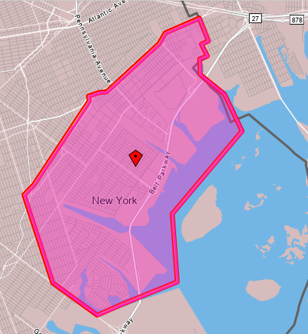
This is on net a bedroom community. In 2019, it had 85,427 employed residents and 39,382 jobs. Very few people both live and work in this area – only 4,005. This is an even smaller proportion than is typical in the city, where 8% of employed city residents work in the same community board they live in – the study zone is slightly smaller than Brooklyn Community Board 18, but CB 18 writ large also has a lower than average share of in-board workers.
In contrast with the limited extent of in-zone work travel, nearly all employed zone residents, 76,534, work in the city as opposed to its suburbs (and 31,685 of the zone’s 39,382 jobs are held by city residents). Where they work looks like where city workers work in general, since the transportation system other than the Shore Parkway is so radial:
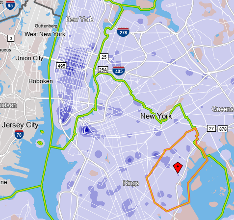
Within the zone, the southwestern areas, that is Mill Basin and Bergen Beach, are vaguely near Utica Avenue, hosting the B46 and hopefully in the future a subway line, first as an extension of the 4 train and later as an independent trunk line.
To the northeast, Canarsie, Starrett City, and Spring Creek are all far from the subway, and connect to it by dedicated buses to an outer subway station – see more details on the borough’s bus map. Canarsie is connected to the L subway station named after it by the B42, a short but high-productivity bus route, and to the 3 and 4 trains at Utica by the B17, also a high-productivity route. Starrett City does not have such strong dedicated buses: it is the outer terminus of the circumferential B82 (which is very strong), but its dedicated radial route, the B83 to Broadway Junction, is meandering and has slightly below-average ridership for its length. Spring Creek is the worst: it is a commercial rather than residential area, anchored by the Gateway Center mall, but the mall is served by buses entering it from the south and not the north, including the B83, the B84 to New Lots on the 3 (a half-hourly bus with practically no ridership), the rather weak B13 to Crescent Street and Ridgewood, and the Q8 to Jamaica.
The implications for bus design
The paucity of east-west throughfares in this area deeply impacts how bus redesign in Brooklyn ought to be done, and this proved important when Eric and I wrote our bus redesign proposal.
First, there are so few crossings between Brooklyn and Queens that the routes crossing between the two boroughs are constrained and can be handled separately. This means that it’s plausible to design separate bus networks for Brooklyn and Queens. In 2018 it was unclear whether they’d be designed separately or together; the MTA has since done them separately, which is the correct decision. The difficulty of crossings argues in favor of separation, and so does the difference in density pattern between the two boroughs: Brooklyn has fairly isotropic density thanks to high-density construction in Coney Island, which argues in favor of high uniform frequency borough-wide, whereas Queens grades to lower density toward the east, which argues in favor of more and less frequent routes depending on neighborhood details.
Second, the situation in Starrett City is unacceptable. This is an extremely poor, transit-dependent neighborhood, and right now its bus connections to the rest of the world are lacking. The B82 is a strong bus route but many rush hour buses only run from the L train west; at Starrett City, the frequency is a local bus every 10-12 minutes and another SBS bus every 10-12 minutes, never overlying to produce high base frequency. The B83 meanders and has low ridership accordingly; it should be combined with the B20 to produce a straight bus route going direct on Pennsylvania Avenue between Starrett City and Broadway Junction, offering neighborhood residents a more convenient connection to the subway.
Third, the situation in Spring Creek is unacceptable as well. Gateway Center is a recent development, dating only to 2002, long after the last major revision of Brooklyn buses. The bus network grew haphazardly to serve it, and does so from the wrong direction, forcing riders into a circuitous route. Only residents of Starrett City have any direct route to the mall, but whereas Starrett City has 5,724 employed residents (south of Flatlands), and Spring Creek has 4,980 workers, only 26 people commute from Starrett City to Spring Creek. It’s far more important to connect Spring Creek with the rest of the city, which means buses entering it from the north, not the south. Our bus redesign proposal does that with two routes: a B6/B82 extension making this and not Starrett City the eastern anchor, and a completely redone B13 going directly north from the mall to New Lots and thence hitting Euclid Avenue on the A/C and Crescent Street on the J/Z.
What about rail expansion?
New York should be looking at subway expansion, and not just Second Avenue Subway. Is subway expansion a good solution for the travel needs of this study zone?
For our purposes, we should start with the map of the existing subway system; the colors indicate deinterlining, but otherwise the system is exactly as it is today, save for a one-stop extension of the Eastern Parkway Line from New Lots to the existing railyard.

Starrett City does not lie on or near any obvious subway expansion; any rail there has to be a tram. But Canarsie is where any L extension would go – in fact, the Canarsie Line used to go there until it was curtailed to its current terminus in 1917, as the trains ran at-grade and grade-separating them in order to run third rail was considered impractically expensive. Likewise, extending the Eastern Parkway Line through the yard to Gateway Center is a natural expansion, running on Elton Street.
Both potential extensions should be considered on a cost per rider basis. In both cases, a big question is whether they can be built elevated – neither Rockaway Parkway nor Elton is an especially wide street most of the way, about 24 or 27 meters wide with 20-meter narrows. The Gateway extension would be around 1.3 km and the Canarsie one 1.8 km to Seaview Avenue or 2.3 km to the waterfront. These should cost around $250 million and $500 million respectively underground, and somewhat less elevated – I’m tempted to say elevated extensions are half as expensive, but this far out of city center, the underground premium should be lower, especially if cut-and-cover construction is viable, which it should be; let’s call it two-thirds as expensive above-ground.
Is there enough ridership to justify such expansion?
Let’s start with Canarsie, which has 28,515 employed residents between Flatlands and the water. Those workers mostly don’t work along the L, which manages to miss all of the city’s main job centers, but the L does have good connections to lines connecting to Downtown Brooklyn (A/C), Lower Manhattan (A/C again), and Midtown (4/5/6, N/Q/R/W, F/M, A/C/E). Moreover, the density within the neighborhood is uniform, and so many of the 28,515 are not really near where the subway would go – Rockaway/Flatlands, Rockaway/Avenue L, Rockaway/Seaview, and perhaps Belt Parkway for the waterfront. Within 500 meters of Rockaway/L and Rockaway/Seaview there are only 9,602 employed residents, but then it can be expected that nearly all would use the subway.
The B42 an B17 provide a lower limit to the potential ridership of a subway extension. The subway would literally replace the B42 and its roughly 4,000 weekday riders; nearly all of the 10,000 riders of the B17 would likely switch as well. What’s more, those buses were seeing decreases in ridership even before corona due to traffic and higher wages inducing people to switch away from buses – and in 2011, despite high unemployment, those two routes combined to 18,000 weekday riders.
If that’s the market, then $500 million/18,000 weekday riders is great and should be built.
Let’s look at Gateway now. Spring Creek has 4,980 workers, but first of all, only 3,513 live in the city. Their incomes are very low – of the 3,513, only 1,030, or 29%, earned as much as $40,000/year in 2019 – which makes even circuitous mass transit more competitive with cars. There’s a notable concentration of Spring Creek workers among people living vaguely near the 3/4 trains in Brooklyn, which may be explained by the bus connections; fortunately, there’s also a concentration among people living near the proposed IBX route in both Brooklyn and Queens.
The area is the opposite of a bedroom community, unlike the other areas within the study zone – only 1,114 employed people live in it. Going one block north of Flatlands boosts this to 1,923, but a block north of Flatlands it’s plausible to walk to a station at Linden at the existing railyard. 51% of the 1,114 and 54% of the 1,923 earn at least $40,000 a year. Beyond that, it’s hard to see where neighborhood residents work – nearly 40% work in the public sector and OnTheMap’s limitations are such that many of those are deemed to be working at Brooklyn Borough Hall regardless of their actual commute destination.
There’s non-work travel to such a big shopping center, but there are grounds to discount it. It’s grown around the Shore Parkway, and it’s likely that every shopper in the area who can afford a car drives in; in Germany, with generally good off-peak frequency and colocation of retail at train stations, the modal split for public transit is lower for shopping trips than for commutes to work or school. Such trips can boost a Gateway Center subway extension but they’re likely secondary, at least in the medium run.
The work travel to the mall is thankfully on the margin of good enough to justify a subway at $50,000/daily trip, itself a marginal cost. Much depends on IBX, which would help deliver passengers to nearby subway nodes, permitting such radial extensions to get more ridership.
