Category: New York
Bus Branching
There are two standard reasons why public transit should limit branching. The first is that it reduces frequency on the branches; this is Jarrett Walker’s reason, and distantly the reason why New York doesn’t interline more than two subway services anywhere except 60th Street Tunnel. The second is that it makes schedules more fragile, first because services have to be scheduled more precisely to alternate among branches, and second because delays on one branch propagate to the others. And yet, rail and bus networks still employ branching, due to benefits including better coverage and focusing frequency where demand is the highest. This is especially common on regional rail, where all services are scheduled and often interact with the mainline network, so the second problem of branching is present no matter what. Metro systems instead have less branching, often because they only serve dense areas so that the main benefits of branching are absent. But what about buses?
I posit that bus branching is more valuable in low-density areas than in high-density areas. If an area only has demand for a bus every 30 minutes, and some farther-out places only have demand for an hourly bus, then it’s fine to branch the route in two. The bus would only be useful with some timed transfers at the inner end – maybe it’s feeding a regional train station with a train every half hour – but the Zurich suburbs have half-hourly clockface schedules with timed bus/rail connections and maintain high mode share for how low their density is.
In the other direction, look at Manhattan specifically. I’ve been looking at its bus network even though I’m only supposed to redesign Brooklyn’s. I’ve mentioned before that my epistemology is that if the presence of factor A makes solution B better, then the absence of factor A should make solution B worse. I noticed that the Brooklyn bus network has very little branching: the only route numbers that branch are the B41 and B38, and the only routes with different numbers that share the majority of their lengths are the B67 and B69 (which reverse-branch). However, Manhattan has extensive branching: the M1/2/3/4 share the Madison and Fifth Avenue one-way pair, and the M101/102/103 share the Third and Lexington one-way pair. Understanding why would be useful even if I only care about Brooklyn: if there is a good reason for Manhattan buses to branch then I should consider adding branching in Brooklyn where appropriate, and even if it’s inappropriate, it’s useful to understand what special circumstances make branching good in Manhattan but not in Brooklyn.
As it is, I don’t believe the branching in Manhattan is useful for Brooklyn. This comes from several reasons, at least one of which implies it’s not really useful for Manhattan either, and by extension for other high-density regions.
Base frequency
You can run a bus that comes every half hour on a schedule, making it possible to interline two hourly routes evenly. With some discipline you can go down to 15 minutes, or possibly even 10: Vancouver runs 12-minute limited buses on 4th Avenue on a clockface schedule with on-board fare collection and shared lanes, but there is signal priority at nearly all intersections and relatively little car traffic since the West Side’s street network is rich in arterial roads and distributes cars across other routes (i.e. Broadway, 12th, and 16th Avenues).
In contrast, it’s not really feasible to run buses on a schedule when they come every 5 minutes. There can be a printed schedule, but buses won’t follow it reliably. Once frequency hits about once every 3 minutes, regular street buses bunch so much that adding more buses doesn’t increase passenger capacity, but even in the 5-10 minute range, schedules are less important than headway management, unless the bus has extensive BRT treatments reducing schedule variance. This means that if a bus comes every 10 minutes and is scheduled on headway management, then branching the route means each branch gets service every 20 minutes scheduled on headway management as well. Few passengers would want to ride such a route. This is the worst region for branching, the 7.5-15 minute range in which branches force passengers to use buses that are both infrequent and irregular.
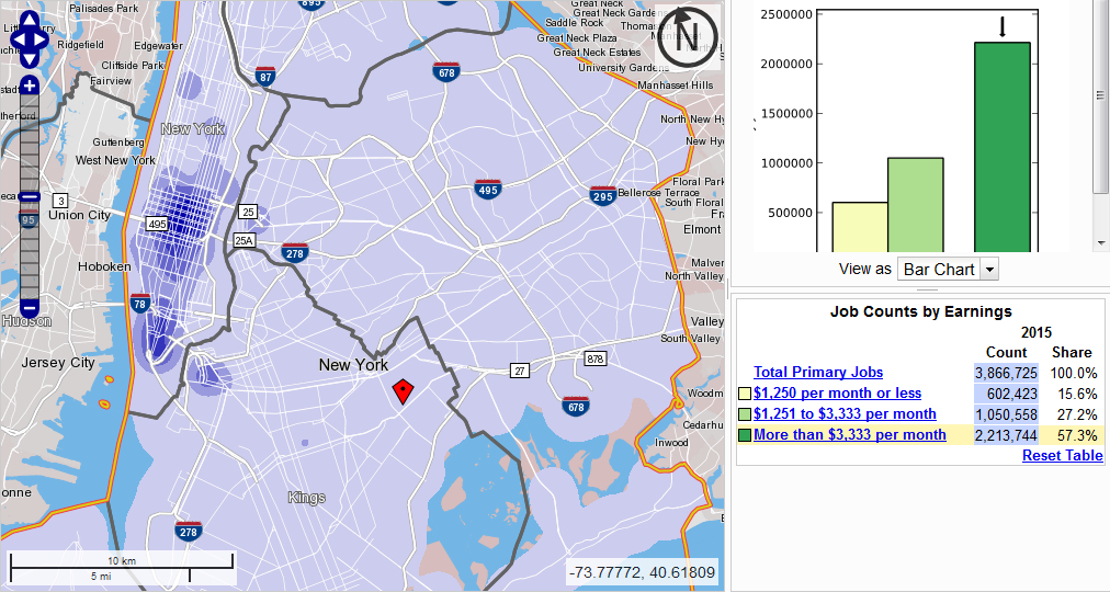
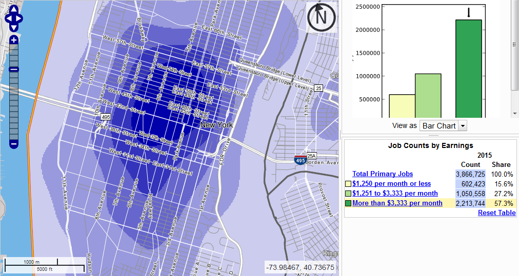
The highest-frequency routes can branch with less risk. If a 5-minute bus branches in two, then each branch gets 10-minute service, at which point reliable schedules are still desirable but not absolutely necessary. How much service do the Manhattan bus trunks run? In the following scheme, peak means the busiest hour in the morning in the peak direction, and off-peak means the lowest frequency between the morning and afternoon peaks, which is usually around 11 am.
M1: 13 buses per hour peak (8 limited, 5 local), 5 off-peak (all local)
M2: 9 peak, 4 off-peak
M3: 6 peak, 6 off-peak
M4: 12 peak (5 limited, 7 local), 6 off-peak (all local)
M101: 6 peak, 6 off-peak (8 in the busiest off-peak hour, 2-3 pm)
M102: 5 peak, 4 off-peak
M103: 5 peak, 4 off-peak
What we see is that Manhattan branches precisely in the worst frequency range. The buses are frequent enough that it’s not possible to run them on a timetable without either much better segregation from traffic than is feasible (even waving away politics) or massive schedule padding, but they still require passengers in Upper Manhattan to wait 10-15 minutes for their specific branch. One might expect that Bus Time would make it easier on passengers by telling them where the bus is, but no, ridership has actually fallen since apps were introduced (and this fall predates the entry of app-hailed TNCs into the city). It turns out passengers like being able to rely on easily memorable clockface schedules, or else on frequencies so high that they only need to wait 5 minutes, not 15.
The street network
Even one-time visitors to New York notice that the avenues in Manhattan are all one-way. This features prominently in the Manhattan bus network, which employs consistent one-way pairs on First/Second, Third/Lex, Madison/Fifth, and Ninth/Tenth. Moreover, again as every visitor to New York knows, Central Park occupies a large blob of land in the middle, interrupting Sixth and Seventh Avenues.
The upshot is that there are more north-south routes north of 110th Street than south of it. This is roughly the branch point on the three trunks that branch (First/Second only carries the M15). In Harlem, there’s demand for buses on Lenox (i.e. Sixth) and Seventh, both of which are two-way there. There’s also commerce on an interpolating route, Manhattan/St. Nicholas, which is effectively 8.5th Avenue in most of Harlem. Farther west, Ninth/Columbus is no longer a useful through-route north of 110th, but instead Tenth/Amsterdam is two-way, and one of the two buses using the Columbus/Amsterdam one-way pair on the Upper West Side, the M11, indeed goes two-way on Amsterdam north of 110th.
This situation occurs very frequently in cities without gridded street networks. One trunk route will split in two, heading to different former villages that were incorporated into the city as it industrialized and grew. Manhattan is unusual among gridded cities in that its avenues are one-way, forcing buses into one-way pairs south of Harlem that, together with Central Park, ensure there are more useful routes north of 110th than south of it. But among cities without a planned street network this is typical.
As a check, let’s look at the bus networks in two ungridded American cities: Boston and Providence. Do they have a lot of interlining, involving one trunk route splitting in two farther out? Yes, they do!
Here is Providence. Going west of Downcity, there are two major routes to Olneyville, Westminster and Broadway, but beyond Olneyville there are four main streets, so each of the two inner corridors carries two bus routes, and one of these four routes even splits in two farther out. Going north, Charles Street carries four routes, branching off at various locations. Going east there’s a bus tunnel to College Hill carrying many routes, but even outside the tunnel, the one-way pair on Angell and Waterman carries three buses, which split in East Providence. And going south and southwest, Broad Street carries multiple routes, and one of its branches, Elmwood, carries two, splitting farther south.
Here is Boston. Unlike in Providence, buses don’t converge on city center, but on subway stations, so the map is much less clean. However, we see the same pattern of trunk routes splitting into branches. For example, going south of Ruggles, many routes go southeast to Dudley and then south on Warren Street, splitting to various destinations in Dorchester, Mattapan, and Hyde Park on the way. Going southwest of Forest Hills we see many routes use Washington Street, some staying on it and branching in Dedham and some veering west to West Roxbury and branching there. Elsewhere in the system we see the same pattern going north of Maverick and Oak Grove, northeast of Malden, west of Harvard (briefly on Mount Auburn), and northwest of Alewife.
One-seat rides and reverse-branching
I have repeatedly criticized the practice of reverse-branching on subway networks, especially New York, in which two train routes share tracks in an outlying area (such as Queens Boulevard) and then split heading into the center (such as Eighth Avenue on the E versus Sixth Avenue on the F). I did so on the same grounds that any branching is suspect: it reduces frequency on specific routes, and makes the schedule more fragile as delays propagate to more of the network. Moreover, the issue of schedule fragility gets worse if many routes share tracks at some point during their journey, whereas with conventional branching there are only two or three branches per trunk and the trunks form self-contained systems. Finally, reverse-branching lacks the main benefit of conventional branching, as it does not concentrate traffic in the core, where there’s most demand.
These issues are present on bus networks, with two modifications:
- The value of one-seat rides is somewhat higher. Transferring between buses is less nice than transferring between subways: in a Dutch study about location decisions, people’s disutility of out-of-vehicle time on buses was 1.5 times as high as on trains.
- Buses can overtake each other and, even without overtakes, run much closer together than trains. The limiting factor to capacity on buses is schedule fragility and bunching and not stopping distances. This means that reverse-branching is less likely to lead to cascading delays – buses do not have a 2-minute exclusion zone behind them in which no buses may enter.
This means that reverse-branching is more defensible on buses than on trains. However, even then, I don’t think it’s a good idea. At least in Manhattan, reverse-branching consists of avenues in Upper Manhattan that have buses going to both the East Side and the West Side: the M7 (serving the Ninth/Tenth pair) and the M102 both run on Lenox, and the M4 and M104 (running on Broadway to Midtown) both run on Broadway in Morningside Heights. These splits both reduce the frequency available to bus riders and should be eliminated. East-west service should be provided with high-quality bus routes on the main streets, especially 125th (which needs a full subway) but also 116th, 135th, 145th, and 155th.
The snag is that grids don’t work well unless they are complete. The Manhattan grid isn’t complete through Upper Manhattan, because 116th and 135th are discontinuous, without a direct connection from Central Harlem to Morningside Heights and West Harlem. However, the M7 route duplicates the 2 and 3 trains, so it’s not necessary for east-west connectivity. The M4 route doesn’t duplicate the subway, but does duplicate the M101, which runs on 125th Street and Amsterdam (and isn’t a reverse-branch because the M11 terminates shortly after 125th), so it’s not useful by itself.
Should buses branch?
There is one solid reason for buses to branch: if the street network has more major routes closer to the center than in outlying areas, then buses running on the outer arterials should come together close to the core. This is common enough on cities with haphazard street networks. It may also be reinforced if there are weak circumferential streets (Sydney is one such example). In contrast, cities with gridded street plans, even broken grids like those of Brooklyn and Tel Aviv, should have little to no bus branching.
If a bus does branch, it should ideally be extremely frequent on the trunk, so that even the branches have decent headway-based service. I’m not willing to commit to a maximum headway, but Barcelona and Toronto both have at worst 8-minute headways on their bus grids, so if that is indeed the maximum then a bus shouldn’t branch if its off-peak frequency is worse than every 4 minutes and better than every 10-20 (the more reliable the timetable is, the lower the upper limit is, since it’s possible to run on a timetable at higher frequency). In my case of interest, Brooklyn, there is exactly one bus route that comes at least every 4 minutes off-peak: the B46 on Utica runs 16 buses per hour in each direction, counting both local and limited (SBS) routes.
The area in which buses absolutely should not branch – strong interconnected networks of arterials (not necessarily grids – Paris’s network counts too), running buses every 5-15 minutes off-peak – is exactly where most strong bus networks are. It’s rare to have a bus that has extremely high frequency all day, because in most functional city such a bus would be a subway already; as it is, Utica has long been New York’s second priority for subway service, after Second Avenue. So for the most part, the places where buses are the strongest are precisely those where branching is the most deleterious. Low-frequency networks, perhaps connecting to a suburban train station with a timed transfer, should add bus branching to their planning toolkit, but high-frequency urban networks should not.
Gentrifier Stereotypes
The American discourse about gentrification is full of stereotypes that the participants don’t recognize as such. For example, a widely-shared Buzzfeed article created an entire theory out of a single busybody who was responsible for half of the police complaints on their West Harlem block. The main check on stereotypes – “that’s racist” – only works when the stereotypes resemble the forms of racism society is most familiar with. The history of white racism against black people in the US is so different that it colors what Americans perceive as racial stereotypes and what they don’t. So as public service, I’d like to give some examples to draw commonalities between stereotypes in other cities I’ve lived in (Tel Aviv, Vancouver, Paris) and familiar anti-gentrification rhetoric.
Tel Aviv
Last decade, there was an influx of black refugees into working-class areas of South Tel Aviv, centered on Levinsky Park. The area is underpriced relative to its job access, courtesy of Central Bus Station, a failed urban renewal project that attracted crime; already in the 1990s it was nicknamed Central Stench (tsaḥana merkazit; Central Station is taḥana merkazit) and lampooned in a popular comic as a literal gateway to hell. The neighborhood’s response was violent, and the discourse within Israel is divided into people who wish the refugees imprisoned and deported from the country and people who wish them forcibly dispersed around the country.
Other parts of South Tel Aviv have been gentrifying since the 1990s, centered on Florentin. South Tel Aviv’s right-wing Jewish working class began connecting the two trends. A few years ago I saw a widely-shared Facebook post claiming that the influx of black refugees is deliberately engineered by developers as a ploy to gentrify the neighborhood. The theory, as I recall, is that black people are so odious that developers are using them to engineer white flight, after which they’ll evict the refugees, demolish the neighborhood’s mid-rise housing stock, and erect luxury towers.
Vancouver
In the last decade or so Vancouver has seen rising rents and even faster-rising housing prices, and the region’s white population is blaming Chinese people. In 2016, British Columbia passed a 15% tax on residential buyers who are not Canadian citizens or permanent residents; the tax was phrased neutrally, but the target was predominantly Chinese, and 21% of correspondence from citizens to the government on the issue was explicitly Sinophobic. In a city with rapid immigration, it should not be a surprise that new buyers tend to be immigrants, often on work or investor visas, but the region has a moral panic about Chinese people buying condos and houses as investments and leaving them empty.
The specific stereotypes of Chinese people in Vancouver vary. When I lived in Vancouver I encountered some light generic stereotyping (“people in Richmond are aggressive drivers”), but nothing connoting poverty, even though Richmond is poorer than Surrey, which some people I met compared with Camden, New Jersey. The language I see in the media concerning housing goes the other way: Chinese immigrants are stereotyped as oligarchs laundering ill-begotten wealth.
Paris
Like people in every other highly-toured region, Parisians hate the tourists. Seeing small declines in city population over the 2009-14 period, city electeds decided to blame Airbnb, and not, say, low housing construction rates (raising rents), a falling birth rate, or commercialization in city center. The mayor of the 1st arrondissement, Jean-Francois Legaret, called Airbnb “a true catastrophe for Central Paris.” The 1st arrondissement has high residential incomes; the lower-income parts of the city are the 10th, 11th, 13th, 18th, 19th, and 20th.
Rich and poor stereotypes
An ethnic or national group can stereotype another group as rich, poor, or both. White stereotypes of black people in the US and Europe are, within each ethnic group, associated with poverty: crime, aggressive physicality, laziness, indifference to education, proclivity for certain kinds of music and sport. Anti-Semitism today invokes stereotypes of the rich: greed, political subversion, disloyalty to the nation, corruption, success with money. Islamophobic stereotypes tend toward stereotypes of poverty, but are sometimes also bundled with stereotypes of Gulf money. In the last few decades Sinophobic stereotypes transitioned from ones of poverty (treating the Chinese as a faceless horde) to ones of wealth, similar to anti-Semitic stereotypes, to the point that people in Vancouver forget Richmond’s low incomes and people in New York forget the high poverty rates of Asian-New Yorkers and the overcrowding in Chinatown.
But as in the case of South Tel Aviv, the stereotypes can merge. The racists in South Tel Aviv blend two groups they hate – middle-class leftists and poor non-Jews – into one mass, blaming them for a trend that is usually blamed on the rich and the middle class. Historically, anti-Semitism was fully blended: the Jew was simultaneously poor and rich, wretched and exploitative, communist and capitalist, overly studious and overly physical. This blending of stereotypes was overt in Nazi propaganda, but also in the softer anti-Semitism directed against immigrants to the US.
The urban as a foreigner
Nationalists and populists stereotype cities like prewar anti-Semites stereotype Jews. The urban poor are lazy criminals, the rural poor are honest workers; the urban rich are exploitative capitalists sucking life out of the country, the rural rich are successful small business leaders; the urban middle class are bo-bo globalists, the rural middle class is the very definition of normality. This mentality is hard to miss in anti-urbanist writers like Joel Kotkin, and more recently in articles trying to portray an opposition between the Real Country (in the US but also in Israel and France) and the Urban Elites.
The definition of what is rural and what is urban is fractal. In the South, Long Island is part of New York; on Long Island, Long Island is Real America, distinct from the city that Long Island’s residents fled in the 1950s and 60s. Within cities the Real Country vs. Urban Elite opposition can involve the outer city vs. the inner city, as in Toronto, where Rob Ford won the mayoral election by appealing to outer-urban resentment of David Miller’s attempt to redistribute street space from cars to public transit. But it is in many cases demographic rather than geographic: the newcomer is the new rootless cosmopolitan.
In this mentality, the newcomer can be a rich gentrifier displacing honest salt-of-the-earth third-generation residents by paying higher rents or a refugee doing the same through living multiple people to a bedroom (or even both, in the case of some San Francisco programmers). In either case, the newcomer is a foreigner who doesn’t belong to the city’s culture and does not deserve the same access to city resources. People who build housing for this foreigner are inherently suspect, as are businesses that cater to the foreigner’s tastes. The demands – removal of access to housing – are the same regardless of whether the foreigners so stereotyped are poor or rich, and the stereotypes of wealth and poverty mix easily. That anti-gentrification activism looks so similar regardless of which social class it targets suggests that ultimately, any argument made is an excuse justifying not liking outsiders very much.
Reverse-Branching Does not Save You the Transfer
I wrote a detailed proposal about why New York should deinterline, and how. I got a lot of supportive comments (in the transit blogging sense, i.e. nitpicking), but also some pushback, arguing that people like their one-seat rides, and making them transfer under a more coherent system would make their riding experience worse. I could go on about how London is facing the same problem and is choosing to invest a lot of money into deinterlining in order to increase train capacity, but in the case of New York, there’s a blunter answer: what one-seat ride? The extent of reverse-branching on the subway does not really give people one-seat rides, and New York City Transit is making service decisions that do not maximize one-seat rides even when doing so would be relatively painless.
Outer branches
Most outer branches with just one route naturally offer direct service to the route’s trunk line. Let’s look at the current subway_map, and compare it with my proposed deinterlining, which is again this:

Today, riders on the West End Line only have service on the D, so they only have a one-seat ride to Sixth Avenue. Riders on the Sea Beach Line only have the N, and riders on the local Brighton Line trains only have the Q, so they only have one-seat rides to the Broadway express trains, and if they want to travel to Prince Street or 8th Street-NYU on the R they have to change trains at Canal, which is not a cross-platform transfer. Only a handful of stations get genuine choice between the two trunk lines: 36th Street on the D and N, and the inner few express stops on the B and Q, say up to Newkirk Avenue. These are express stops, with more ridership than the locals, but they’re not the majority of ridership on the subway in Southern Brooklyn. The majority of riders have to deal with the drawbacks of both reverse-branching (slow, infrequent trains) and coherent service (fewer one-seat rides).
Queens Boulevard has the same situation: local and express patterns mix up in a way that makes the choice of one-seat rides much weaker than it appears on the map. Riders at the local stations can choose between the M and the R, two trains that are never more than a few blocks apart in Midtown; only one station on either line is inconvenient to access from the other, 57th Street/7th Avenue, the least busy stop on the Broadway Line in Midtown on a passengers per platform basis (49th and 5th have less ridership but have two platform tracks and no Q service). The express stops get more serious choice, between the E and F, but those are just three stations: Jackson Heights-Roosevelt Avenue, Forest Hills-71st Avenue, and Kew Gardens-Union Turnpike. Queens Plaza has E, M, and R service, but passengers actually getting on at Queens Plaza can equally get on at Queensboro Plaza and ride the N, W, or 7.
Genuine choice between two relatively widely-separated trunk lines on the same trunk only exists in two and a half places in New York: the Central Park West Line offers a choice between the B and C trains, the Nostrand Avenue Line offers a choice between the 2 and 5 trains, and the inner half of the White Plains Line offers a choice between the 2 and 5 trains off-peak (at the peak the 5 runs express, so local stations only get the 2).
Cross-platform transfers
New York is blessed with cross-platform interchanges, usually between local and express trains on the same line. Riders on the 1 train are used to transferring to the 2 and 3 trains cross-platform at 96th Street; in the morning, the 1 train’s busiest point is actually from 103th Street to 96th, and not heading into Midtown. With 170,000 boardings at its stations north of 96th per weekday, the 1 is much busier than Nostrand (with 60,000 weekday boardings) or the combined total of local Central Park West stations from 72nd to 116th (with 65,000 boardings). It’s also slightly busier than the White Plains Road Line, let alone the inner segment with both 2 and 5 service (which has 95,000 boardings).
In Queens, a similar situation occurs on the 7. The stations east of Queensboro Plaza, excluding 74th Street-Broadway (where the transfer to the Queens Boulevard Line is), have a total of 215,000 weekday boardings. The trains fill at the outer end and then discharge at 74th Street as most passengers transfer, not cross-platform, to the faster Queens Boulevard Line; then they fill again at the stations to the west and discharge at Queensboro Plaza, which has a cross-platform transfer to the N and W.
This is relevant to some of the few segments of the subway where reverse-branching offers choice between different trunk lines. Passengers on the Nostrand Avenue Line could transfer cross-platform at Franklin Avenue, where the platforms aren’t much narrower than at 96th Street and Broadway, where passenger volumes are almost three times as high. Similarly, passengers on the Central Park West Line and its branches to Washington Heights and Grand Concourse could transfer cross-platform at 125th Street or at Columbus Circle; Columbus Circle is extremely busy already with origin-and-destination traffic, and the interchanges between local and express passengers could not possibly overwhelm it.
Only one place has a difficult connection: 149th Street-Grand Concourse, the interchange between the 2, 4, and 5 trains. This also happens to be the most difficult deinterlining project in general, because of the merger of the 2 and 3 further south; it requires either closing the northernmost two stations on the 3, or opening up a few blocks of Lenox Avenue to construct a pocket track. Because of the disruption involved, this project can be left for last, and come equipped with more passageways at 149th Street, just as London is first deinterlining the Northern line to the south (raising peak capacity on the Bank branch from 26 trains per hour to 32) and leaving the north for later (which would raise capacity further to 36 tph).
NYCT has deinterlined in the past
Upper Manhattan witnessed two deinterlinings in the second half of the 20th century, one in the 1950s and another in the 1990s. The service NYCT inherited from its three predecessor networks had systematic route nomenclature taking into account conventional and reverse branching.
On the IRT, West Side trains were numbered 1 (to Van Cortlandt Park), 2 (to the White Plains Road Line), and 3 (to Harlem-148th Street), and Lexington trains were numbered 4 (to the Jerome Avenue Line), 5 (to the White Plains Road Line), and 6 (to the Pelham Line); 2, 4, and 5 trains ran express, 3 and 6 trains ran local, and 1 trains could be either local or express. In the 1950s, NYCT changed this system on the West Side so that all 1 trains became local and all 3 trains became express. This was the result of track layout: the junction at 96th Street is flat if 3 trains have to cross over to the local tracks and 1 trains have to cross over to the express tracks, but under today’s present service pattern there are no at-grade conflicts. NYCT chose capacity and reliability over offering one-seat rides from West Harlem and Washington Heights to the express tracks.
On the IND, trains were identified by letters. A, C, and E trains ran on Eighth Avenue and B, D, and F trains on Sixth Avenue; A and B trains went to Washington Heights, C and D trains to Grand Concourse, and E and F trains to the Queens Boulevard Line. Local and express trains were identified using letter doubling: a single letter denoted an express train, a doubled one (e.g. AA) a local. The single vs. double letter system ended up discontinued as few trains consistently run express (just the A and D) and several run a combination of local and express (the B, E, F, N, and Q), and NYCT slowly consolidated the trains on Eighth and Sixth Avenue until there were only seven services between them. Eventually the B and C switched northern terminals, so that now the C runs as the local version of the A and the B as something like the local version of the D. Passengers in Washington Heights who wish to use Sixth Avenue Line have to transfer.
The situation on the IND wasn’t as clean as the deinterlining on the IRT. But it shows two important things. First, changes in train service have made the original reverse-branching less tenable from an operational perspective. And second, the value of a one-seat ride from Washington Heights or Central Harlem to local tracks is limited, since everyone takes the express train and transfers at Columbus Circle.
How Deinterlining Can Improve New York City Transit
New York is unique among the major subways of the world in the extent of interlining its network has. All routes share tracks with other routes for part of the way, except the 1, 6, 7, and L. The advantage of this system is that it permits more one-seat rides. But the disadvantages are numerous, starting with the fact that delays on one line can propagate to nearly the entire system, and the fragile timetables lead to slower trains and lower capacity. New NYCT chief Andy Byford just released a plan calling for investment in capacity, called Fast Forward, focusing on accessibility and improved signaling, but also mentioning reducing interlining as a possibility to increase throughput.
I covered the interlining issue more generally in my article about reverse branching, but now I want to explain exactly what it means, having learned more about this issue in London as well as about the specifics of how it applies to New York. In short, New York needs to reduce the extent of reverse branching as much as possible to increase train speed and capacity, and can expect serious gains in maximum throughput if it does so. It should ultimately have a subway map looking something like this:
Lessons from London
In London, there is extensive interlining on the Underground, but less so than in New York. The subsurface lines form a complex interconnected system, which also shares tracks with one branch of the Piccadilly line, but the Northern, Central, Victoria, Jubilee, and Waterloo and City lines form closed systems (and the Bakerloo line shares tracks with one Overground line). The Northern line reverse-branches: it has two central trunks, one through Bank and one through Charing Cross; one southern segment, with through-trains to both trunks; and two northern branches, each sending half its trains to each trunk. The other closed systems have just one trunk each, and as a result are easier to schedule and have higher capacity.
As the Underground moves to install the same high-capacity signaling on more and more lines, we can see what the outer limit of throughput is on each system. The Northern line’s new moving-block signaling permits 26 trains per hour on the Bank trunk and 22 on the Charing Cross trunk. When the Battersea extension opens, reverse branching on the south will end, pairing the older line to Morden with Bank and the new extension with Charing Cross, and capacity will rise to 32 tph per trunk. Planned improvements to transfer capacity at Camden Town, the northern branch point, will enable TfL to permanently pair each northern branch with one central trunk, raising capacity to 36 tph per trunk. Moreover, TfL expects moving block signaling to raise District line capacity from 24 tph to 32, keeping the current reverse branching. The Victoria line already runs 36 tph and the Jubilee line soon will too, while the Central line runs 35 tph. So 36 vs. 32 seems like the difference coming from the final elimination of reverse branching, while more extensive reverse branching reduces capacity further.
The reason complex branching reduces capacity is that, as delays propagate, the schedule needs to incorporate a greater margin of error to recover from unexpected incidents. It also slows down the trains, since the trains are frequently held at merge points. The general rule is that anything that increases precision increases capacity (such as automation and moving block signaling) and anything that reduces precision reduces capacity; reverse branching reduces timetable precision, because each train can be delayed by incidents on more than one line, making delays more common.
What deinterlining in New York entails
NYCT has its work cut out for it when it comes to deinterlining. There are eight different points in the system where reverse-branching occurs – that is, where lines that do not share track in Manhattan (or on the G trunk outside Manhattan) share tracks elsewhere.
- The 2 and 5 trains share tracks on the Nostrand Avenue Line.
- The 2 and 5 also share tracks in the Bronx.
- The A and C trains share tracks on the two-track narrows through Lower Manhattan and Downtown Brooklyn.
- The A and D share the express tracks on Central Park West while the B and C share the local tracks.
- The E and F share the express tracks on Queens Boulevard, while the M and R share the local tracks, the E and M share the tunnel from Queens to Manhattan, and the N, R, and W share a different tunnel from Queens to Manhattan.
- The B and Q share tracks in Brooklyn, as do the D and N.
- The F and G share tracks in South Brooklyn.
- The M shares the Williamsburg Bridge tracks with the J/Z but runs in Manhattan on the same tracks as the F.
NYCT should work to eliminate all of the above reverse branches. The easiest to start with is #6: the junction at DeKalb Avenue should be set to keep the B and D trains together and to keep the N and Q together rather than to mix them so that the B shifts to the Q tracks and the D to the N tracks. This requires no changes in physical infrastructure, and has especially high benefits as the junction delays trains by several minutes in each direction. Moreover, the loss of one-seat rides is minimal: the BDFM and NQRW run closely parallel in Manhattan and intersect with a transfer at Herald Square in addition to the inconveniently long BQ/DNR transfer at Atlantic Avenue.
Another relatively easy reverse branch to eliminate is #8, a recent introduction from the 2010 service cuts. Previously, today’s M route in Queens and Manhattan was covered by the V train, which turned on the Lower East Side, while the M ran the same route as the J/Z, merging onto the R and thence the N in Brooklyn at rush hour. Today’s route is thus an M-V merger, which railfans including myself hoped would help decongest the L by creating an alternative route from Williamsburg to Midtown. Unfortunately, such decongestion has not happened, perhaps because gentrification in Williamsburg clusters near the L and not near the J or M.
Harsh decisions
Fixing the reverse-branching at DeKalb Avenue and on the Williamsburg Bridge is painless. The other reverse branches require a combination of hard decisions and new infrastructure.
Fixing reverse branches #3 and #4 requires no capital investment, just political will. Reverse branch #4 is there because there’s demand for two routes’ worth of capacity in the tunnel from Brooklyn but there’s only one express line on Eighth Avenue, and that in turn is the result of reverse branch #3; thus these two issues should be tackled together.
NYCT should decide between having the A and C trains run express between 145th and 59th Streets and the B and D trains run local, or the other way around. This is not an easy decision: either Washington Heights or Grand Concourse would get consigned to local trains. North of 145th the total number of boardings is 102,000 at B/D stations compared with 79,000 on the A/C, but conversely Concourse riders can change to the express 4 trains whereas Washington Heights’ only alternative is the local 1. However the A and C run, express or local, the E should run the opposite in Manhattan – it can merge to either the local or express tracks – and the express trains should continue to Brooklyn. The map I made doesn’t distinguish local from express service, but my suspicion is that Washington Heights should get express trains, on account of its long commutes and lack of fast alternatives.
The same problem of harshness occurs in reverse-branch #5. In theory, it’s an easy fix: there are three track pairs in Queens (Astoria, Queens Boulevard local, Queens Boulevard express) feeding three tunnels to Manhattan (63rd, 60th, and 53rd Streets). In practice, the three Manhattan trunks have astonishingly poor transfers between them in Midtown. Nonetheless, if it does nothing else, NYCT should remove the R from Queens Boulevard and route all 60th Street Tunnel trains to Astoria; together with fixing DeKalb Avenue, this would separate the lettered lines into two closed systems, inherited from the BMT and IND.
However, undoing the connection between the BMT and the IND probably requires constructing a transfer station in Long Island City between Queensboro Plaza and Queens Plaza, which involves a few hundred meters of underground walkway. Even then, the connection cannot possibly be convenient. The saving grace is that Eighth Avenue, Sixth Avenue, and Broadway are close enough to one another that passengers can walk to most destinations from any line.
Subsequently, NYCT should make a decision about whether to send express Queens Boulevard trains to 63rd Street and Sixth Avenue and local trains to 53rd and Eighth, as depicted in the above map, or the other way around. The problem is that the merge point between 53rd and 63rd Street Tunnels is one station east of Queens Plaza, at a local station, and thus the true transfer point is Roosevelt Avenue, far to the east. Riders on the local stations west of Roosevelt would get no choice where to go (though they get little choice today – both the E and M serve 53rd Street, not 63rd). The argument to do things as I depict them is to give the local stations access to 53rd Street; the argument to switch the lines is that there is more demand on 53rd than 63rd and also more demand on the express tracks than the local tracks, so the busiest lines should be paired. However, this in turn runs into turnback capacity limitations on the E in Manhattan, at the World Trade Center bumper tracks.
Potentially, NYCT could try to convert 36th Street into an express station, so that passengers could connect cross-platform. But such a dig would be costly and disruptive to operations. There were plans to do this at 59th Street on the 1/2/3 a few decades ago, for the transfer to the A/B/C/D, but nothing came of them.
Where new infrastructure is needed
The remaining reverse branches get increasingly more difficult. Already #7 requires new turnouts. The South Brooklyn trunk line has four tracks, but there’s not enough demand (or space in Manhattan) to fill them, so only the local tracks are used. There are occasional railfan calls for express service using the F, but it’s better to instead use the express tracks to segregate the G from the F. The G could be turned at Bergen Street on the local tracks, while the F could use the express tracks and then transition to the locals on new turnouts to be constructed at Carroll Street.
Also in the category of requiring new turnouts is #1: Rogers Avenue Junction is set up in a way that briefly forces the 2, 3, and 5 trains to share a short segment of track, limiting capacity. This can be resolved with new turnouts just east of the junction, pairing Nostrand Avenue Line with the local tracks and the West Side and the portion of the Eastern Parkway Line east of Nostrand with the express tracks and the Lexington Avenue Line. Trains on Eastern Parkway could either all go local, or keep the current mixture of local trains to New Lots (currently the 3) and express trains to Utica (currently the 4), skipping a total of two stations. This fix also reduces passengers’ access to one-seat rides, but at least there is a reasonable cross-platform transfer at Franklin Avenue, unlike on Queens Boulevard or at 145th Street and St. Nicholas.
And then there is #2, by far the most difficult fix. Demand on the White Plains Road branch in the Bronx is too strong to be a mere branch: the combined number of boardings at all stations is 166,000 per weekday, and besides, the line branches to Dyre Avenue near its outer end and thus needs the frequency of either a trunk or two branches to ensure adequate service to each other branch. This is why it gets both the 2 and 5 trains. There is unfortunately no infrastructure supporting a switch eliminating this track sharing: the 4 and 5 trains could both use this line, but then the 2 has no way of connecting to Jerome Avenue Line without new tunnels.
On the map, I propose the most obtrusive method of fixing this problem: cutting the 3 trains to a shuttle, with a new pocket track at 135th Street, letting passengers transfer to the 2, ideally cross-platform. With all through-trains running on the 2, there is no need (or space) for the 5 on White Plains Road, and instead the 5 should help boost the frequency on Jerome Avenue. In addition, some work is required at Woodlawn, which currently has bumper tracks, fine for a single branch but not for a non-branching trunk line (the bumper tracks on the L limit throughput to 26 tph no matter how good the electronics are).
Additional infrastructure suggested by deinterlining
Deinterlining is a service increase. Lines that today only get half or two-thirds service would get full trunk frequency: Second Avenue Subway would get the equivalent of the Q and N trains, the Astoria Line would get the entirety of 60th Street Tunnel’s capacity, Eighth Avenue would get more express trains, and 63rd Street Line and the South Brooklyn Line would get more than just the half-service of the F. With six track pairs on the lettered lines through Midtown and six north and east (Central Park West*2, Second Avenue, Astoria, Queens Boulevard*2), there is no room for natural branching to give more service to busy areas than to less busy ones.
One solution to this situation is targeted development on weak lines. Even with half service, South Brooklyn has underfull F trains, and Southern Brooklyn’s B, D, N, and Q trains aren’t much busier, making this entire area an attractive target for upzoning.
However, it’s more interesting to look at lines with extensions that suggest themselves. Second Avenue Subway has the obvious extension north to Harlem in phase 2, and a potential subsequent extension under 125th Street to Broadway, which is less obvious but popular among most area railfans (including one of my inside sources at NYCT). The Astoria Line has a natural extension to LaGuardia, ideally elevated over Ditmars to capture local ridership on Astoria as well as airport traffic; while the steel el structures in New York are soundboxes, it is possible to build quieter els using concrete (as on the 7 el over Queens Boulevard in Sunnyside) or a mixture of concrete columns and a steel structure (as on the Metro 2 and 6 els here in Paris).
The Nostrand Avenue Line provides an especially interesting example of a subway extension suggested by deinterlining. The terminal, Flatbush Avenue, was intended to be temporary, and as a result has limited turnback capacity. To prevent it from constraining the entire 2 route, which became the city’s most crowded even before Second Avenue Subway began decongesting the 4 and 5, it would be prudent to extend the line to Sheepshead Bay as the city intended when it planned the line in the 1910s.
In contrast, a subway extension under Utica, a stronger bus corridor than Nostrand with a strong outer anchor at Kings Plaza, loses value under deinterlining. It could only get a branch and thus have lower capacity than Nostrand. It would also definitely force branching on the express trains, whereas without such an extension they could run as a single unbranched line between Woodlawn and New Lots Avenue via Jerome Avenue, Lexington Avenue, and Eastern Parkway. A Utica subway should wait until there is political will to fund an entirely new crossing into Manhattan, presumably via Williamsburg to help decongest the L.
A second extension I have occasionally mooted, a subway under Northern, loses value even more. Such a subway would be a fourth trunk line in Queens and have to come at the expense of capacity on Queens Boulevard. It is only supportable if there is an entirely new tunnel to Midtown, passing under the mess that is the tracks in Long Island City.
A deinterlined New York City Subway
Fast Forward proposes moving block signaling on the most crowded subway segments, but typically only on trunks, not branches, and in some cases not even entire trunks. But in the long term, New York should transition to moving blocks and automation on all lines – at the very least the highly automated system used on the L, but ideally fully driverless operation, in recognition that wages are going up with economic growth but driver productivity isn’t. Simultaneously, deinterlined operations should allow tph counts in the mid 30s or even more (Metro 13 here runs 38 tph and Metro 14 runs 42).
Instead of the potpourri of lines offered today, there would be fewer, more intense lines. Nomenclature would presumably change to deal with the elimination of some services, clarifying the nature of the subway as a nine-line system in which five lines have four tracks and four lines have two. Each of these fourteen track pairs should be able to support a train every 90-105 seconds at the peak; not all lines have the demand for such frequency, and some have capacity-limiting bumper tracks that aren’t worth fixing (e.g. the 1 at Van Cortlandt Park), but many lines have the infrastructure and the demand for such capacity, including the express lines entering Midtown from Uptown or Queens.
Off-peak, too, service would improve. There is ample capacity outside rush hour, but turning the system into one of lines arriving every 4-5 minutes with strategic transfers rather than every 8-10 minutes would encourage people to take the trains more often. The trains would simultaneously be faster and more reliable, since incidents on one line would wreck service on other trains on the same line but leave the rest of the network unaffected.
With service improvements both during and outside rush hour, New York could expect to see substantial increases in ridership. Raising peak frequency from the current 24 tph to 36 tph on the busiest lines (today’s 2/3, 4/5, A/D, and E/F) is equivalent to building an entirely new four-track subway trunk line, and can be expected to produce similar benefits for passengers. The passups that have become all too familiar for riders on the 4, L, and other busy trains would become a thing of the past unless ridership rose 50% to match the increase in capacity.
Consumption Theory and Gentrification
I recently saw an article about location decisions by education in the Netherlands. The article discusses the impact of rail investment on different social classes, and claims that,
A recent study by Teulings et al. (2018) uses microdata to quantify the differences in the willingness to pay for particular locations between the high and low educated (omitting the medium education level) (Figure 2). It shows willingness to pay for the job availability (based on the locally available transport infrastructure to commute to these jobs) and urban amenities such as parks and historic scenery at the location. The highly educated (right panel) are very sensitive to the quality of a location.
The claim is that educated people prefer central cities, in this case Amsterdam, because of their consumption amenities. This is the consumption theory of gentrification, which holds that the process of gentrification is caused by a middle-class taste for urban amenities. However, this theory appears incorrect, on several levels. The references cited in the paper for location decisions do not really bear out consumption theory. Moreover, the history of gentrification strongly suggests that, if consumption amenities are at all involved, then they have been stable for at least a hundred years.
Instead of consumption theory, the best explanation is that location decisions are about jobs. Certain cities have higher production amenities, especially for the middle class, leading the middle class to preferentially move to them to obtain higher-income jobs. The choice of neighborhood is then driven by access to skilled jobs, usually in the CBD but sometimes also in new job clusters. If there’s gentrification, the cause is insufficient housing in closer-in areas, leading to spillover to adjacent neighborhoods.
The references
The internal reference cited for it in the paper, the work of Coen Teulings, Ioulia Ossokina, and Henri de Groot, breaks down willingness to pay higher rents in expensive cities (i.e. Amsterdam) based on job access and several consumption amenities. The paper’s headline numbers superficially bear out consumption theory: table 7 on page 23 says that job availability is only responsible for 38% of low-education people’s variance in willingness to live in expensive cities and 28% of high-education people’s variance; the rest comes from amenities. However, a closer reading suggests that this is not really about consumption amenities.
First, that 28% of middle-class location choice comes from job access does not mean 72% comes from amenities. Observed consumption amenities are only 18% (and only 14% for low-education workers); the rest is unobserved amenities (30%), which are a residual rather than any identified amenities, and covariances between jobs and amenities.
Moreover, the consumption amenities listed are proximity to restaurants, monuments, parks, and a university. Is a university really a consumption amenity for the middle class? This is unlikely. Graduates don’t really have the same consumption basket as students. Instead, what’s more likely is that universities provide skilled employment for a particular set of high-education workers (namely, academics and other researchers), who are willing to pay extra to be near work; academic job markets are so specialized that access to non-academic high-education work isn’t as important. Of course, universities also have extensive working-class employment, but a university janitor can get a similar job at a non-academic environment, and therefore has no reason to locate specifically near a university rather than another source of work, such as a hospital or office building.
Finally, there is a second reference in the article, reinforcing its claims about location decisions with American data. This is a paper by David Albouy, Gabriel Ehrlich, and Yingyi Liu. Albouy, Ehrlich, and Liu’s text does not endorse consumption theory – on the contrary, their discussion blames “policies and regulations that raise rents by creating artificial shortages in housing supply” (pp. 28-29). On the question of consumption theory, the results of the study are inconclusive. They do not look directly at amenities that critics of gentrification typically implicate in causing the middle class to displace the poor; the amenities they consider include mild climate, clean air, and a sea view.
The history of gentrification
The word “gentrification” was coined in 1964 to describe the process in Islington. However, Stephen Smith has argued from looking at historical rents that the process goes much further back. He finds evidence of gentrification in Greenwich Village in the 1910s and 20s. Already then, the middle class was beginning to move into the Village, previously a working-class district. Jane Jacobs moved in in 1935. She was income-poor, as were many other people in the Depression, but on any marker of class, she was solidly comfortable: her father was a doctor, she herself was a high school graduate and had some college education at a time when most Americans had never gone to high school, and her job was in journalism, at the time a middle-class career path.
In the 1950s and 60s, this process continued in full swing, in the Village and other inner neighborhoods of New York, such as the Upper West Side, which unlike the Upper East Side was originally rowdy (West Side Story is set there). Developers were building taller buildings, to Jacobs’ consternation, to house the growing middle-class demand.
I focus on early gentrification in New York and not London, because in this era, the American middle class was fleeing cities. In the 1950s New York was poorer than its suburbs. The wealthiest strata of the city had decamped to Westchester and Fairfield Counties starting in the 1910s and 20s (in 1930 Westchester had 520,000 people, more than half of today’s level, and more than Long Island). Then in the 1950s and 60s this process spread to the entire white middle class, causing a population surge on Long Island, in New Jersey, and in the parts of Westchester and Fairfield that the rich hadn’t already settled in. Moreover, companies were moving out of city centers, often to be closer to the CEO’s home, including General Electric (which moved to the town of Fairfield in 1974) and IBM (which moved to Armonk in 1964). Middle-class taste at the time was firmly suburban.
A better explanation for the early history of gentrification in New York concerns the subway. Before the subway opened, the working class had to live right next to the Lower Manhattan CBD and commute on foot. The els did provide some options for living farther uptown, but they were slow and noisy (they were only electrified around the time the subway opened) and until the early 20th century the working class could not afford the 5-cent fare. This led to extreme levels of overcrowding just outside the CBD, most infamously on the Lower East Side. In 1900, most of Manhattan was open to the middle class but only the Lower East and West Sides were open to the working class. By 1920, the fast subway and the 5-cent fare (held down despite post-WW1 inflation) made all of Manhattan open to everyone, making it easier for the middle class to outbid the poor for housing in the Village.
Production theory
The paper cited at the beginning of this post does not profess consumption theory; it claims that both production and consumption amenities explain gentrification. However, the actual work within the paper leans heavily toward production. It looks at the effect of opening a new rail line from the suburbs to Amsterdam, and finds that this leads to middle-class displacement of lower-education residents, who have less use for the train service. This is also consistent with what working-class residents of some Parisian banlieues think: a newspaper article I can no longer find cites people within Seine-Saint-Denis complaining that all Grand Paris Express will do is raise their rents.
In addition to being more consistent with Dutch and American evidence and American history, production theory benefits from not relying on special local explanations for a global trend. A process that began at similar development levels in the US and Western Europe is unlikely to be about American race relations. Even Tokyo is seeing gentrification in the sense that industrial waterfront areas are redeveloped, if not in the sense of mass displacement seen in New York, London, and other cities with stricter zoning.
There is no burning middle-class desire to live near poor people – quite the opposite, in fact. When the middle class does begin gentrifying a neighborhood, it’s because it offers convenient access to jobs. The same is true on the level of an entire city: San Francisco did not magically become a nicer place to live in when the current tech boom began – if anything, rising rents have led to a homelessness problem, which makes professional workers uncomfortable. A city that wishes to forestall gentrification will make it easy to build housing in the areas with the best job access, in order to encourage people to have short commutes rather than seeking increasingly marginal neighborhoods to move to.
Why is Second Avenue Subway Phase 2 So Expensive?
I am only loosely following the news about the second phase of Second Avenue Subway. The project, running from 96th Street to 125th, with a short segment under 125th to Lexington, passing under the 4, 5, and 6 trains, is supposed to be cheap. In the 1970s, work began on Second Avenue Subway before the city went bankrupt, and there are extant tunnel segments built cut-and-cover in East Harlem between the station sites. The stations need to be dug, but the plan dating back to 2003 was to build them cut-and-cover as well, with local disruption for only a few blocks around 106th, 116th, and 125th Streets. Only one part would be difficult: going deep under 125th, under the preexisting subway. And yet, costs are very high, and the design seems to be taking a wrong turn.
In the early 2000s, the cost projections were $3.7 billion for phase 1 (actual cost: $5 billion, but much of the difference is inflation), and $3.3 billion for phase 2 (projected cost: at least $6 billion). Since then, there have been changes. For about a year I heard rumors that the preliminary engineering had been done wrong, and it was impossible to use the preexisting tunnel segments. Then I heard that no, it’s actually possible to use the existing tunnels. But a few days ago I heard that even though it’s possible, the MTA is now planning to demolish the existing tunnels and build the entire project deep underground using tunnel-boring machines.
With the information generally given out at community meetings, it’s hard to know what’s exactly going on. However, the fact that the MTA is talking about this suggests extreme disinterest in cost control. Cut-and-cover construction is cheaper than TBMs, per a 1994 paper by Godard, Barrié, Zhang, et al, looking at French urban rail costs since the 1970s. The tradeoff is that it forces rail lines to go underneath streets, which is disruptive to pedestrians and merchants, or demolish private property. Fortunately, Second Avenue is a wide, straight throughfare, and requires no such demolitions, while the disruption would be localized to areas that are scheduled to get subway stops as part of the project. Metro extensions here and in a number of other European cities are constructing stations cut-and-cover and the tunnels between them with TBMs; Metro Line 12’s online documents state that station construction involves just 18 months of digging.
It’s possible that the need to turn to 125th Street is messing up the plan to do everything cut-and-cover. While the turn itself can be done with minimal demolitions (the inside of the curve has a few small buildings, and there’s also an alignment slightly farther east that goes under vacant land while maintaining a 90-meter curve radius), going underneath the Lexington Avenue Line requires diving deep, and then there is no advantage to cut-and-cover. Building cut-and-cover under existing lines is difficult, and in that case, TBMs are warranted.
If the problem is 125th Street, then I would propose extending phase 2 and then breaking it apart into two subphases. Phase 2.0 would be cut-and-cover and open stations at 106th, 116th, and possibly 125th and 2nd temporarily. Phase 2.5 would involve driving TBMs under 125th Street all the way to Broadway; this could be done with a large-diameter TBM, with the platforms contained within the bore and vertical access dug so as to avoid the intersecting north-south subways. 125th Street has 30,000 crosstown bus boardings according to the MTA, which would make it the busiest bus corridor in the city per km: 10,000 per km, compared with 8,000 on the busiest single route, the M86. It is a priority for subway expansion, and if it’s for some reason not possible to easily build from 96th and 2nd to 125th and Lex in one go then the entire project should be extended to 125th and Broadway, at somewhat higher cost and far higher benefits.
The reason phase 1 was so expensive is that the stations were mined from small digs, rather than built cut-and-cover as is more usual. The idea was to limit street disruption; instead there was street disruption lasting 5 years rather than 1.5, just at small bore sites at 72nd and 86th rather than throughout the station boxes’ footprints. The TBM drive and systems cost together $260 million per kilometer, compared with $125 million on Paris’s Metro Line 1 extension, but the stations cost $750 million each, compared with $110 million.
It’s crucial that the MTA not repeat this mistake in phase 2, and it’s crucial that area transit activists hold the MTA’s feet to the fire and demand sharp cost control. Even taking the existing premiums as a given, cut-and-cover stations should not cost more than $200 million each, which means phase 2 as planned should cost $600 million for stations, about $330 million for systems, and another $350 million for overheads. At $1.3 billion this still represents high cost per kilometer, about $500 million, but it’s based on actual New York cost items, which means it’s plausible today. There is no excuse for $6 billion.
Do Rich and Poor People Work in Different Neighborhoods?
There are workplaces where most employees are high-income, for example office towers (or office parks) hosting tech firms, law firms, or banks. There are workplaces where most employees are working-class, for example factories, warehouses, and farms. Does this lead to a difference in commuting patterns by class? I fired up OnTheMap two days ago and investigated. This is American data, so it stratifies workers by income, education, industry, or race rather than by job class. I generated maps for New York and saw the following:
There are three income classes available, and I looked at the bottom and top ones, but the middle one, still skewed toward the working class, looks the same as the bottom class. The biggest observation is that Midtown is dominant regardless of income, but is more dominant for middle-class workers (more than $40,000 a year) than for low-income ones (up to $15,000, or for that matter $15,000-40,000).
The colors are relative, and the deepest shade of blue represents much more density for middle-class workers, even taking into account the fact that they outnumber under-$15,000 workers almost four to one. Among the lowest-income workers we see more work on Queens Boulevard and in Williamsburg, Flushing, and the Hub, but these remain tertiary workplaces at most. The only place outside Midtown, Lower Manhattan, or Downtown Brooklyn (which includes all city workers in Brooklyn due to how the tool works, so it looks denser than it is) that has even the third out of five colors for low-income workers is Columbia, where the low-income job density is one-third that of Midtown, and where there is also a concentration of middle-class workers.
The same pattern – job centers are basically the same, but there’s more concentration within the CBD for the rich – also appears if we look at individual neighborhoods. Here is the Upper East Side versus East Harlem:
I chose these two neighborhoods to compare because they exhibit very large differences in average income and are on the same subway line. Potentially there could be a difference between where East Siders and West Siders work due to the difficulty of crosstown commuting, so I thought it would be best to compare different socioeconomic classes of people on the same line. With the East Side-only restriction, we see two Uptown job centers eclipse Columbia: Weill-Cornell Medical Center in Lenox Hill at the southeast corner of the Upper East Side, and Mount Sinai Hospital at the northwest corner.
One place where there is a bigger difference is the definition of Midtown. Looking at the general job distribution I’d always defined Midtown to range between 34th and 59th Street. However, there are noticeable differences by income:
For the middle class, Midtown ranges from 34th to 57th Street and peaks around 47th. For the lowest-income workers, it ranges from 28th to 49th and peaks in the high 30s. My best explanation for this is that Midtown South and Union Square are more retail hubs than office hubs, featuring department stores and shopping centers, where the rich spend money rather than earning it.
In a deindustrialized country like the US or France, the working class no longer works in manufacturing or logistics. There are a lot of truck drivers today – 3.5 million in the US – but in 1920 the American railroad industry peaked at 2.1 million employees (source, PDF-p. 15), nine times today’s total, in a country with one third the population it has today and much less mobility. Manufacturing has plummeted as a share of employment, and is decreasing even in industrial exporters like Germany and Sweden. Instead, most poor people work at places that also employ many high-skill, high-income workers, such as hospitals and universities, or at places where they serve high-income consumption, such as retail and airports.
Since the working class works right next to the middle class, the nature of bosses’ demands of workers has also changed. Low-skill works now involves far more emotional labor; in Singapore, which makes the modern-day boss-worker relationships more explicit than the Anglosphere proper, there are signs all over the airport reminding workers to smile more. Nobody cares if auto workers smile, but they’re no longer a large fraction of the working class.
With the working class employed right next to the middle class, there is also less difference in commuting. For the most part, the same transportation services that serve middle-class jobs also serve working-class jobs and vice versa. This remains true even across racially segregated communities. The patterns of white New York employment are similar to those of middle-class New York employment, and those of black, Hispanic, and Asian employment are similar to those of the working class, with small differences (Asians are somewhat more concentrated in Flushing, and blacks in Downtown Brooklyn, reflecting the fact that blacks are overrepresented in public employment in the US and all city workers in Brooklyn are counted at Court Square).
This is true provided that opportunities for transportation are available without class segregation. This is not the situation in New York today. Commuter rail actually serves working-class jobs better than middle-class jobs, since Penn Station is closer to the department stores of 34th Street than to the office towers in the 50s. However, it’s priced for the middle class, forcing the working class to take slower buses and subway trains.
When I posted the above maps on Twitter, Stephen Smith chimed in saying that, look, the poor are less likely to work in the CBD than the middle class, so everywhere-to-everywhere public transportation is especially useful for them. While Stephen’s conclusion is correct, it is not supported by this specific data. In the $40,000 and up category, 57% of city jobs are in Manhattan south of 60th Street, compared with 37% in the $15,000-40,000 and under-$15,000 categories. It’s a noticeable difference, but not an enormous one. The reason Stephen is correct about how rides crosstown transit is different: people who can afford cars are very likely to drive if the transit option is not good (which it isn’t today), whereas people who can’t are stuck riding slow crosstown buses; in contrast, for CBD-bound commutes, the subway and commuter rail work reasonably well (especially at rush hour) and driving is awful.
Instead of trying to look specifically at low-income and middle- and high-income job centers, it’s better to just plan transit based on general commute patterns, and let anyone take any train or bus. This doesn’t mean business as usual, since it requires transitioning to full fare integration. Nor does this mean ignoring residential segregation by income, which in some cases can lead to transit segregation even in the face of fare integration (for example, the crosstown buses between the Upper East Side and Upper West Side have mostly white, mostly middle-class riders). Finally, this doesn’t mean relying on middle-class transit use patterns as a universal use case, since the middle class drives in the off-hours or to off-CBD locations; it means that relying on middle-class transportation needs could be reasonable. It just means that the rich and poor have substantially the same destinations.
An even bigger implication relates to questions of redevelopment. There have been periodic complaints from the left about gentrification of jobs, in which working-class job sites are turned over to high-end office and retail complexes. For example, Canary Wharf used to be the West India Docks. In New York, Jane Jacobs’ last piece of writing before she died was a criticism of Greenpoint rezoning, in which she specifically talked up the importance of keeping industrial jobs for the working class. But since the big deindustrialization wave, developments brought about by urban renewal, gentrification, and industrial redevelopment have not had any bias against providing employment for the poor. It’s not the factory jobs that the unionized working class still culturally defines itself by, but it’s industries that are hungry for low-skill work, and in many cases are serious target of unionization drives (such as universities).
When are Express Trains Warranted? Part 2: Subways
Last week, I wrote about which regional rail lines should run local and express trains and which should only run locals. I gave various guidelines, specific to that mode of transportation. The same question makes a lot of sense for subways (or elevated lines), and is especially important for large cities building new metro networks, typically in developing countries. The key difference is that subway trains almost always run so frequently that the only way to have local and express services is to build four-track mainlines, like in New York. So really, this is a question about when it’s useful to build four-track subways instead of two-track subways.
Costs
The cost of a four-track subway is higher than that of a two-track subway. However, the difference depends on the method of construction. Cut-and-cover four-track subways do not appear to be much more expensive than two-track subways; in the 1900s, New York had little to no cost premium over London or Paris. The First Subway’s underground segments, slightly less than half of which are four-track, cost $39 million per km in today’s money, compared with about $29 million per km in Paris in the same era (see sources in this post). The Metropolitan line in London cost about the same: £1.3 million for 6 km in the early 1860s, or about $30 million per km.
In contrast, boring four tracks appears to cost twice as much as boring two. It’s hard to find examples, since four-track bores are extremely rare; the examples I do know, such as the East River Tunnels and the tunnel carrying the Lexington Avenue Line under the Harlem River, are short. There are bound to be efficiencies in engineering and sitework reducing the cost of boring, just as there are with cut-and-cover, but the majority of the cost of tunneling is the boring and the systems. The majority of the rest is stations, and the local stations can be built for not much of a premium over stations on a two-track line, but the express stations require considerably more excavation.
What this means is that cities that build cut-and-cover should probably aim to build four tracks rather than two. In retrospect, Paris should have built Metro Line 1 with four tracks: the narrowest street segment, Rue de Rivoli, runs for 3 km and is about 20-23 meters wide, which can take four tracks if there are only local platforms, and everything else is at least 30 meters and could take four tracks and express platforms. The only express station under Rivoli would probably be Chatelet, where there is a wide square where the station footprint could expand.
The question of whether to use cut-and-cover today is a separate issue. It’s easier for the first few lines than for subsequent lines, which have to cross under the old lines. Nonetheless, it’s still in use, for example in China; the lack of express tracks on Chinese subways has led to criticism on some railfan forums, particularly by Japanese railfans, who are used to the fast express trains of the JRs through urban areas. But in India, the longest underground segment in Delhi, on the Yellow Line, appears to be bored, running deep under Old Delhi. The one potential pitfall is that bored tunnels, while generally more expensive to construct than cut-and-cover tunnels if wide streets are available, are nimbler, making it easier to build lines to high standards, with wide curves.
Benefits
The two obvious benefits of express subways are speed and capacity. New York averages a decent speed, just under 30 km/h, buoyed by express trains that average about 36 km/h. When frequency on both the local and express tracks is adequate, which it regrettably isn’t most of the time in New York, it’s possible to use cross-platform local/express transfers to improve trip times even for people on the local stations.
The capacity benefits are sometimes compromised by transfers. In New York, the express tracks are consistently more crowded than the local tracks on the main lines, and the Upper West Side in particular sees the city’s most overcrowded trains on the express tracks run alongside the second least crowded on the local tracks. However, on the East Side, the local and express trains under Lexington are both quite full. The number of passengers they carry would overwhelm any two-track line: to carry the same number of passengers on just two tracks at the current peak frequency, each train would need about 2,100 passengers, more per unit of train floor area than the most crowded Tokyo Metro lines.
There are also indirect effect of four-tracking. The most distant stations are presumably express-only, or, if not, passengers will transfer to an express train at the first opportunity. This means that adding local stops does not increase trip times for passengers far out, which in turn argues in favor of tighter stop spacing on local trains, to provide more coverage. Evidently, New York has one of the smallest interstations (on local trains) of any major metro network in the world, surpassed only by Paris, which built the Metro without regard for the suburbs. Second Avenue Subway, built with just two tracks, has wider stop spacing than other Manhattan north-south mainlines, missing 79th Street, with the planned phase 2 stopping at 106th instead of 103rd and 110th.
Network effects
I have hammered repeatedly that metro systems need to avoid three pitfalls of network planning:
- Tangential lines, starting as radial farther out but becoming circumferential closer in rather than staying radial and serving city center.
- Reverse-branching: a common trunk in an outlying area splitting into branches in city center, the opposite of the more normal branching arrangement.
- Missed connections, in which two lines intersect without a transfer.
It is easier to miss connections when the stop spacing is wider, because city centers are so small that line 1 can easily miss the road that line 6 will later run under. The Paris Metro has just one missed connection (M5/M14), and the city made a failed effort in the 1900s to bring Line 5 to what would be the transfer station, Gare de Lyon. New York has only two missed connections among the lines built from 1900 to the 1920s (Junius/Livonia on the 3/L, Bowling Green/Whitehall on the 4-5/RW), both of which are easy to fix; the city’s tens of misses come from a deliberate decision to avoid transfers in the lines built in the 1930s. Systems with wider stop spacing have more opportunities for missed connections, such as Tokyo, Shanghai, and Moscow.
Four-track mainlines short-circuit this problem doubly. First, fewer lines are required to provide the same coverage and capacity. On the eve of the Great Depression, New York had six subway mainlines, three with four tracks and three with two, and 2 billion annual riders. Even if a city insists that all transfer stations be express (which is the case in New York among lines built before the 1930s, though at one station express platforms were only retrofitted decades later), there are fewer potential intersections; at city center, even the express lines are unlikely to have very wide stop spacing.
Moreover, it’s fine to miss transfers on express lines. The reason missed connections are so bad is that the alternative option typically requires a three-seat ride. For example, the 1 passes between Columbus Circle-59th Street and 50th Street without a connection to the E train, leaving connecting passengers with one of two options: ride to Times Square and transfer there, which is both a detour and a very long walk between the platforms, or change to the B or D at 59th and then again to the E at 53rd; the latter option is the faster one, saving about 5 minutes of in-vehicle time and 3 minutes of transfer time.
But if one of the transfers is cross-platform, then a three-seat ride is less onerous. This is especially true if this transfer is local/express on a long shared trunk line, where the transfer stations usually don’t get as crowded as between two separate trunks. This means that it’s possible, if there is no better option, to have local-only transfers. Two of the top stations in New York, 53rd/Lex and Columbus Circle, are local-only transfers.
Scale
Small cities don’t need to think about express trains very much. Transit cities with about 2 million people in their metro areas, such as Vienna, Stockholm, Prague, Budapest, and Hamburg, make do with a handful of metro lines, sometimes supplemented by regional rail. But as they grow, the number of urban rail lines they need grows to the point that a coherent two-track network is too difficult, not to mention too slow. Paris manages to make do with the RER acting as the express layer, but outside India and Pakistan, cities that are just beginning to build their metro networks don’t have large legacy commuter rail networks to leverage for express service. In Africa between the Sahara and South Africa, nearly everything has to be built from scratch, and the same is true of Bangladesh and much of Southeast Asia and Latin America.
Moreover, in developing countries, a large number of cities either are megacities or can expect to grow to that size class soon. This is less true in Latin America, nearly all of which has at- or below-replacement birth rates, already high urbanization rates, and negative net migration (thus, the main case for four-track subways in Bogota hinges on the fact that the city has absurdly wide roads for cut-and-cover, not on future scale). However, in poor countries with high birth rates and low urbanization rates, cities can expect to increase their population many times over in the next few decades. Lagos and Dhaka are already huge, and midsize cities such as Nairobi, Kampala, Dar es Salaam, Addis Ababa, Khartoum, Accra, Abidjan, Douala, and Sanaa can expect to grow to that size class within a generation, as can midsize cities in countries with lower birth rates, such as Chittagong, Hanoi, and Ho Chi Minh City. In such cities, transportation planning should presume much greater scale than may seem warranted today.
A smaller-scale version of this principle can be found in cities that are growing rapidly due to immigration, especially Singapore but also Sydney, Melbourne, Toronto, Vancouver, and Stockholm. Such cities might want to consider infrastructure investments based not on their present-day population levels, but on those that they can expect after 30 more years of high migration rates. Vancouver and Stockholm are too small for express subways no matter what, and Toronto has already built its central spines with two tracks (and is upgrading its regional rail network to act as an express layer), but Singapore, Sydney, and Melbourne should all think about how to plan for the possibility that they will have 10 million people within 50 years.
The MTA’s Bus Redesign Plan
Two weeks ago I wrote about the Brooklyn bus redesign I’m working on with Eric Goldwyn. The MTA, which is aware of our efforts, came up with its own plan. So far details are scant; there is a presentation available online, which talks about goals (“network redesign,” “higher frequency”) but no specifics (“a more gridded network,” “6-minute off-peak frequency on the main routes”).
At least so far, the goals seem solid. The MTA has the following list of improvements:
- Redesign the network from top to bottom based on customer input, demographic changes, and travel demand analysis. Provide better connectivity and more direct service in every neighborhood
- Optimize the existing network with community consultation by removing closely-spaced and underutilized stops and making street design changes on select corridors in coordination with NYC DOT
- Expand off-peak service on strategic routes using a toolbox of service strategies including increased frequency and demand based service adjustments
- Expand Traffic Signal Priority (TSP) to allow an approaching bus to hold a green light or shorten a red light
- Seek exclusive busways on priority corridors to give buses full access in major congested areas
- Identify opportunities for new bus lanes and queue jumps in 2018
- Advocate for strengthened NYPD enforcement of bus lanes to keep bus stops and travel lanes clear throughout the system
- Recommend dedicated transit-priority traffic teams to focus enforcement in key areas to ensure buses move quickly through trouble spots
- Use Bus Lane Enforcement Cameras mounted on buses to automatically identify violations and issue tickets. Advocate for legislation to expand beyond the existing 16 authorized routes
- Install tap readers to speed up the boarding process so buses spend less time waiting at stops
- Introduce all-door boarding to allow riders to get on through any door of the bus
- Explore options for a future cashless system to maximize reductions in boarding time
- Expand fare enforcement on regular bus service to reduce evasion and restore fare revenue
The main problems only appear toward the end, with the implementation of off-board fare collection and all-door boarding. The insistence on “fare enforcement,” which could mean regular proof of payment (POP) inspections but could also mean worse, such as armed cops (not practiced in New York on SBS but practiced on some other US systems, like BART) or holding the bus during inspection (which New York does practice, unlike Berlin and other German-speaking cities). Overall I’m relatively sanguine about Andy Byford specifically – he’s not American and is not used to American levels of police militarization.
However, another aspect of the POP proposal is troubling: the connection with tap readers. The plan’s full text (which is barely more detailed than what I quote above) mentions that POP should come with the so-called New Fare Payment System, or NFPS, which New York is currently planning to roll out starting in 2019, continuing until 2023. The NFPS is based on worst industry practices cobbled from American and British ideas. Here is my second post ever, discussing the plans for smartcards in New York in 2011. New York ignored (and keeps ignoring) the smartcard implementations in a number of East Asian cities in its zeal to make people treat their credit card as a transit fare card, ensuring the agency can surveil all passengers; perhaps Americans lack the values of freedom and individual privacy of Japan and Singapore.
New York also ignored (and keeps ignoring) the POP implementations in cities with paper tickets, such as most of Central Europe. Smartcards are not required for POP: the German-speaking world has POP with paper tickets, as did Vancouver on SkyTrain and some bus lines even before the Compass Card debacle. In Singapore I saw a ticket inspection on a bus even before EZ-Link; I had a magnetic farecard at the time. Given the enormous waste coming from making passengers line up and pay the driver, it’s imperative to move toward POP as soon as possible, even if it means equipping inspectors with MetroCard readers rather than smartcard readers. MetroCard may only last for five years if the NFPS schedule doesn’t keep slipping, but handheld magnetic card readers are a cheap technology whereas making buses idle while passengers dip cards one at a time is not so cheap.
The zeal to go cash-free is the final troubling aspect of New York’s ideas about fare payment, especially when bundled with the idea that the bank card is the fare card. Not everyone has a local bank account. Tourists don’t (and even cards that are supposed to work abroad don’t always). Low-income city residents don’t, either: 11.7% of New York households have no bank account, and they disproportionately appear to be in poverty, judging by which neighborhoods they are most concentrated in. The MTA has always treated anonymous smartcards as an afterthought, and going cash-free means there is no recourse for the unbanked or even for many tourists.
Nor is cash-free operation even necessary. An on-board farebox is compatible with POP. In this system, riders can board from any door, and the driver will begin moving as soon as all passengers have boarded, even if not all passengers have paid yet. Riders with valid transfers or season passes need not do anything. Riders with a pay-per-ride smartcard and no transfer should tap their card at a validator at any bus door or bus stop (validators are cheap that blanketing the system with them is practically free). The remaining passengers should walk to the farebox and pay there; perhaps some busy stations should get fareboxes, as all SBS stops do in New York today, but if the MTA only expects a few smartcard-free, non-transfer passengers at a stop, then having them pay on board a moving bus should not be a problem.
I’d like to stress that other than the ongoing hiccups of the English-speaking world with fare payment systems (hiccups that it seems to export to Paris), the plan appears good, from what few details the MTA has released. There are plans for increasing the average distance between bus stops, adding more bus lanes, getting serious about signal preemption, raising off-peak frequency, and letting passengers board from all doors. The MTA really is noticing that its bus system is collapsing and really is making serious plans to avert a death spiral.
When are Express Trains Warranted? Part 1: Regional Rail
The Regional Plan Association has a detailed regional rail proposal out. It’s the same one from the Fourth Plan that I’ve criticized here, on Streetsblog, and on Curbed, but with more explanation for how the service should run, with stopping patterns and frequency.
There are some good aspects there, like a section about the importance of electrification and multiple-units, though it stops short of calling for full electrification and replacement of locomotives with EMUs; the focus on off-peak frequency is also welcome. There are also bad ones, like the claim on p. 32 that it’s difficult to impossible to provide through-running using the existing Penn Station tracks used by New Jersey Transit. Foster Nichols told me that there are some difficulties with grades but they should be doable if NJT commits to an all-EMU fleet, and reminded me that the ARC studies judged through-running using these station tracks and new tunnels feasible. What he expressed to me as a difficulty turned into a near-impossibility in the report, in order to justify the $7 billion Penn Station South project.
But I want to focus on one particularly bad aspect of the proposal: the stopping patterns. The RPA is proposing three distinct stopping patterns on pp. 32-45, with three separate brands: Metro, in the city and some inner suburbs; Regional Express (RX), in the suburbs; and Trans-Regional Limited (TRL), providing intercity service to New Haven, Ronkonkoma, Philadelphia, and other major stations outside the built-up area. Even as the plan talks about the importance of making sure suburban trains serve urban stations in order to give them frequent service through overlay, the stopping patterns suggest the opposite.
The proposal involves trains from the suburbs expressing through most city stations (including the infill) even on two-track lines, like the Port Washington Branch. Metro trains would make all current stops plus additional infill to Bayside, and RX trains would only serve Willets Point, Flushing, and Bayside, and then run from Bayside to Port Washington. A similar pattern happens from Jamaica to Valley Stream, resulting in the Babylon, Long Beach, and Far Rockaway Branches all having to share a track pair. Moreover, the RX trains may themselves be divided into local and express trains, for example on the New Haven Line.
This is bad practice. On a two-track line, there’s no real reason to skip a handful of inner stations just to guarantee the outer ones express service. If anything, the need to schedule trains on the same tracks would lead to more fragile timetables, requiring more schedule padding. My analysis from 2.5 years ago found that the LIRR Main Line is padded 32% and the Babylon Branch is padded 19%: that is, the scheduled travel time on the Main Line (up to Ronkonkoma) is 32% more than the travel time imputed from line speed limits and current fleet acceleration performance. Patrick O’Hara, who the RPA study even quotes as a source elsewhere, investigated this issue separately, looking at best-case timetables, and found that some runs are padded 40-50%.
In Switzerland, trains are padded 7%, and I’m told that in Japan, after the Amagasaki accident showcased the safety problems of overly precise schedules, pads are about 5%. Express trains and locals mixed on the same line make it harder to maintain tight enough reliability for low schedule padding; this way, on an all-local line, trip times may match those of express trains on mixed lines, as they do in my analysis above. The best analogy is the RER B going to the north: the express trains are 4 minutes faster than the local trains, skipping 9 stops. The stop penalty on the RER B is higher, closer to 7 minutes over 9 stops, but the shared tracks with local trains (and with the RER D between Gare du Nord and Chatelet-Les Halles) means that there’s a fudge factor in the schedule, so it’s not possible to reliably do better than 4 minutes, and the trains end up visibly crawling on the mainline.
The reader familiar with technical transit advocacy in the Bay Area may interject, what about Caltrain? Clem Tillier has no trouble proposing timetables mixing local trains, express trains, and high-speed rail on the same track pair with timed overtakes, and a 7% pad. So why am I down on this concept in New York? The answer is line complexity. Caltrain is a simple two-track back-and-forth, and HSR is generally more punctual than legacy trains because it runs for long stretches on high-quality dedicated tracks, so it’s unlikely to introduce new variability to the line. In contrast, the RPA plan for regional rail in New York involves extensive branching, so that train schedules depend on trains elsewhere on the line. In this case, introducing more complexity through local/express sharing is likely to require more schedule padding, erasing the speed advantage.
In general, my questions to establish guidelines for where express trains are warranted are,
- How long is the line, measured in the number of stations? More stations encourage more express trains, because more stations can be skipped. In higher speed zones, stop penalties are higher, but at equal line length measured in km, higher speeds and fewer local stations reduce the benefit of express trains.
- How frequent are trains? At low frequency, local stations need more frequency, so express runs are less useful. At very high frequency, there may not be capacity for different stopping patterns unless the line has four tracks. On a two-track line, the optimum frequency for a local/express alternation is about 6-12 trains per hour, 3-6 local and 3-6 express, with a single mid-line overtake. Multiple overtakes on a single line are possible, but more fragile, so they are a bad idea except in special circumstances.
- What is the demand for travel? Express trains work best if there are a few distinguished stations at regular intervals, or else if the line is long and there is strong demand at the far end; if the inner stations are very strong then it’s more important to give them higher local frequency. When performing this analysis, it’s important to make sure station ridership levels reflect genuine demand rather than service. For example, Caltrain express stops have high ridership in large part because of their better service, not nearby density, as shown in Clem Tillier’s analysis. The LIRR Main Line has far more ridership at Mineola and Hicksville than the other stations on the trunk and also far more service, but Patrick explains that this is due to better highway access, so it’s genuine demand and not just a reflection of better service.
Caltrain needs express service because it has about 20 stations between San Francisco and San Jose, depending on the amount of infill and anti-infill desired; a target frequency of 8-10 peak trains per hour; and strong demand on the outer stations, especially for reverse-peak trips. In New York, none of the two-track lines meets the same standard. Some are too short, such as the Port Washington Branch. Others are too busy, such as the Harlem Line, Babylon Branch, and LIRR Main Line. Yet others have too much demand clustering in the inner stations, such as the Erie lines and the North Jersey Coast Line.
On four-track lines, it’s always easier to run express service. This doesn’t mean it should always be run: the upper New Haven Line is a strong candidate for relegating all commuter trains to the local tracks, making all stops, giving the express tracks to intercity trains. The Northeast Corridor Line in New Jersey is a dicey example: past Rahway there are four tracks, but intercity trains could run at very high speeds, making track sharing on the express tracks difficult. My service pattern map has express trains skipping Edison and Metuchen, but it’s just two stations, making it better to just run local beyond Rahway to clear the express tracks for high-speed rail.
It’s tempting to draw proposals involving intense metro-style regional rail service only serving the urban and inner-suburban stations; I’ve had to argue against such plans on some MBTA lines. The problem is that trains from the outer suburbs are still necessary and still going to pass through the inner suburbs, and in most cases they might as well stop at those stations, which need the frequency more than the outer suburbs need the few minutes of speedup.
