Category: New York
Consumption Theory and Gentrification
I recently saw an article about location decisions by education in the Netherlands. The article discusses the impact of rail investment on different social classes, and claims that,
A recent study by Teulings et al. (2018) uses microdata to quantify the differences in the willingness to pay for particular locations between the high and low educated (omitting the medium education level) (Figure 2). It shows willingness to pay for the job availability (based on the locally available transport infrastructure to commute to these jobs) and urban amenities such as parks and historic scenery at the location. The highly educated (right panel) are very sensitive to the quality of a location.
The claim is that educated people prefer central cities, in this case Amsterdam, because of their consumption amenities. This is the consumption theory of gentrification, which holds that the process of gentrification is caused by a middle-class taste for urban amenities. However, this theory appears incorrect, on several levels. The references cited in the paper for location decisions do not really bear out consumption theory. Moreover, the history of gentrification strongly suggests that, if consumption amenities are at all involved, then they have been stable for at least a hundred years.
Instead of consumption theory, the best explanation is that location decisions are about jobs. Certain cities have higher production amenities, especially for the middle class, leading the middle class to preferentially move to them to obtain higher-income jobs. The choice of neighborhood is then driven by access to skilled jobs, usually in the CBD but sometimes also in new job clusters. If there’s gentrification, the cause is insufficient housing in closer-in areas, leading to spillover to adjacent neighborhoods.
The references
The internal reference cited for it in the paper, the work of Coen Teulings, Ioulia Ossokina, and Henri de Groot, breaks down willingness to pay higher rents in expensive cities (i.e. Amsterdam) based on job access and several consumption amenities. The paper’s headline numbers superficially bear out consumption theory: table 7 on page 23 says that job availability is only responsible for 38% of low-education people’s variance in willingness to live in expensive cities and 28% of high-education people’s variance; the rest comes from amenities. However, a closer reading suggests that this is not really about consumption amenities.
First, that 28% of middle-class location choice comes from job access does not mean 72% comes from amenities. Observed consumption amenities are only 18% (and only 14% for low-education workers); the rest is unobserved amenities (30%), which are a residual rather than any identified amenities, and covariances between jobs and amenities.
Moreover, the consumption amenities listed are proximity to restaurants, monuments, parks, and a university. Is a university really a consumption amenity for the middle class? This is unlikely. Graduates don’t really have the same consumption basket as students. Instead, what’s more likely is that universities provide skilled employment for a particular set of high-education workers (namely, academics and other researchers), who are willing to pay extra to be near work; academic job markets are so specialized that access to non-academic high-education work isn’t as important. Of course, universities also have extensive working-class employment, but a university janitor can get a similar job at a non-academic environment, and therefore has no reason to locate specifically near a university rather than another source of work, such as a hospital or office building.
Finally, there is a second reference in the article, reinforcing its claims about location decisions with American data. This is a paper by David Albouy, Gabriel Ehrlich, and Yingyi Liu. Albouy, Ehrlich, and Liu’s text does not endorse consumption theory – on the contrary, their discussion blames “policies and regulations that raise rents by creating artificial shortages in housing supply” (pp. 28-29). On the question of consumption theory, the results of the study are inconclusive. They do not look directly at amenities that critics of gentrification typically implicate in causing the middle class to displace the poor; the amenities they consider include mild climate, clean air, and a sea view.
The history of gentrification
The word “gentrification” was coined in 1964 to describe the process in Islington. However, Stephen Smith has argued from looking at historical rents that the process goes much further back. He finds evidence of gentrification in Greenwich Village in the 1910s and 20s. Already then, the middle class was beginning to move into the Village, previously a working-class district. Jane Jacobs moved in in 1935. She was income-poor, as were many other people in the Depression, but on any marker of class, she was solidly comfortable: her father was a doctor, she herself was a high school graduate and had some college education at a time when most Americans had never gone to high school, and her job was in journalism, at the time a middle-class career path.
In the 1950s and 60s, this process continued in full swing, in the Village and other inner neighborhoods of New York, such as the Upper West Side, which unlike the Upper East Side was originally rowdy (West Side Story is set there). Developers were building taller buildings, to Jacobs’ consternation, to house the growing middle-class demand.
I focus on early gentrification in New York and not London, because in this era, the American middle class was fleeing cities. In the 1950s New York was poorer than its suburbs. The wealthiest strata of the city had decamped to Westchester and Fairfield Counties starting in the 1910s and 20s (in 1930 Westchester had 520,000 people, more than half of today’s level, and more than Long Island). Then in the 1950s and 60s this process spread to the entire white middle class, causing a population surge on Long Island, in New Jersey, and in the parts of Westchester and Fairfield that the rich hadn’t already settled in. Moreover, companies were moving out of city centers, often to be closer to the CEO’s home, including General Electric (which moved to the town of Fairfield in 1974) and IBM (which moved to Armonk in 1964). Middle-class taste at the time was firmly suburban.
A better explanation for the early history of gentrification in New York concerns the subway. Before the subway opened, the working class had to live right next to the Lower Manhattan CBD and commute on foot. The els did provide some options for living farther uptown, but they were slow and noisy (they were only electrified around the time the subway opened) and until the early 20th century the working class could not afford the 5-cent fare. This led to extreme levels of overcrowding just outside the CBD, most infamously on the Lower East Side. In 1900, most of Manhattan was open to the middle class but only the Lower East and West Sides were open to the working class. By 1920, the fast subway and the 5-cent fare (held down despite post-WW1 inflation) made all of Manhattan open to everyone, making it easier for the middle class to outbid the poor for housing in the Village.
Production theory
The paper cited at the beginning of this post does not profess consumption theory; it claims that both production and consumption amenities explain gentrification. However, the actual work within the paper leans heavily toward production. It looks at the effect of opening a new rail line from the suburbs to Amsterdam, and finds that this leads to middle-class displacement of lower-education residents, who have less use for the train service. This is also consistent with what working-class residents of some Parisian banlieues think: a newspaper article I can no longer find cites people within Seine-Saint-Denis complaining that all Grand Paris Express will do is raise their rents.
In addition to being more consistent with Dutch and American evidence and American history, production theory benefits from not relying on special local explanations for a global trend. A process that began at similar development levels in the US and Western Europe is unlikely to be about American race relations. Even Tokyo is seeing gentrification in the sense that industrial waterfront areas are redeveloped, if not in the sense of mass displacement seen in New York, London, and other cities with stricter zoning.
There is no burning middle-class desire to live near poor people – quite the opposite, in fact. When the middle class does begin gentrifying a neighborhood, it’s because it offers convenient access to jobs. The same is true on the level of an entire city: San Francisco did not magically become a nicer place to live in when the current tech boom began – if anything, rising rents have led to a homelessness problem, which makes professional workers uncomfortable. A city that wishes to forestall gentrification will make it easy to build housing in the areas with the best job access, in order to encourage people to have short commutes rather than seeking increasingly marginal neighborhoods to move to.
Why is Second Avenue Subway Phase 2 So Expensive?
I am only loosely following the news about the second phase of Second Avenue Subway. The project, running from 96th Street to 125th, with a short segment under 125th to Lexington, passing under the 4, 5, and 6 trains, is supposed to be cheap. In the 1970s, work began on Second Avenue Subway before the city went bankrupt, and there are extant tunnel segments built cut-and-cover in East Harlem between the station sites. The stations need to be dug, but the plan dating back to 2003 was to build them cut-and-cover as well, with local disruption for only a few blocks around 106th, 116th, and 125th Streets. Only one part would be difficult: going deep under 125th, under the preexisting subway. And yet, costs are very high, and the design seems to be taking a wrong turn.
In the early 2000s, the cost projections were $3.7 billion for phase 1 (actual cost: $5 billion, but much of the difference is inflation), and $3.3 billion for phase 2 (projected cost: at least $6 billion). Since then, there have been changes. For about a year I heard rumors that the preliminary engineering had been done wrong, and it was impossible to use the preexisting tunnel segments. Then I heard that no, it’s actually possible to use the existing tunnels. But a few days ago I heard that even though it’s possible, the MTA is now planning to demolish the existing tunnels and build the entire project deep underground using tunnel-boring machines.
With the information generally given out at community meetings, it’s hard to know what’s exactly going on. However, the fact that the MTA is talking about this suggests extreme disinterest in cost control. Cut-and-cover construction is cheaper than TBMs, per a 1994 paper by Godard, Barrié, Zhang, et al, looking at French urban rail costs since the 1970s. The tradeoff is that it forces rail lines to go underneath streets, which is disruptive to pedestrians and merchants, or demolish private property. Fortunately, Second Avenue is a wide, straight throughfare, and requires no such demolitions, while the disruption would be localized to areas that are scheduled to get subway stops as part of the project. Metro extensions here and in a number of other European cities are constructing stations cut-and-cover and the tunnels between them with TBMs; Metro Line 12’s online documents state that station construction involves just 18 months of digging.
It’s possible that the need to turn to 125th Street is messing up the plan to do everything cut-and-cover. While the turn itself can be done with minimal demolitions (the inside of the curve has a few small buildings, and there’s also an alignment slightly farther east that goes under vacant land while maintaining a 90-meter curve radius), going underneath the Lexington Avenue Line requires diving deep, and then there is no advantage to cut-and-cover. Building cut-and-cover under existing lines is difficult, and in that case, TBMs are warranted.
If the problem is 125th Street, then I would propose extending phase 2 and then breaking it apart into two subphases. Phase 2.0 would be cut-and-cover and open stations at 106th, 116th, and possibly 125th and 2nd temporarily. Phase 2.5 would involve driving TBMs under 125th Street all the way to Broadway; this could be done with a large-diameter TBM, with the platforms contained within the bore and vertical access dug so as to avoid the intersecting north-south subways. 125th Street has 30,000 crosstown bus boardings according to the MTA, which would make it the busiest bus corridor in the city per km: 10,000 per km, compared with 8,000 on the busiest single route, the M86. It is a priority for subway expansion, and if it’s for some reason not possible to easily build from 96th and 2nd to 125th and Lex in one go then the entire project should be extended to 125th and Broadway, at somewhat higher cost and far higher benefits.
The reason phase 1 was so expensive is that the stations were mined from small digs, rather than built cut-and-cover as is more usual. The idea was to limit street disruption; instead there was street disruption lasting 5 years rather than 1.5, just at small bore sites at 72nd and 86th rather than throughout the station boxes’ footprints. The TBM drive and systems cost together $260 million per kilometer, compared with $125 million on Paris’s Metro Line 1 extension, but the stations cost $750 million each, compared with $110 million.
It’s crucial that the MTA not repeat this mistake in phase 2, and it’s crucial that area transit activists hold the MTA’s feet to the fire and demand sharp cost control. Even taking the existing premiums as a given, cut-and-cover stations should not cost more than $200 million each, which means phase 2 as planned should cost $600 million for stations, about $330 million for systems, and another $350 million for overheads. At $1.3 billion this still represents high cost per kilometer, about $500 million, but it’s based on actual New York cost items, which means it’s plausible today. There is no excuse for $6 billion.
Do Rich and Poor People Work in Different Neighborhoods?
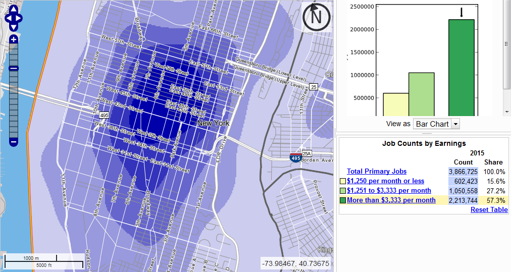
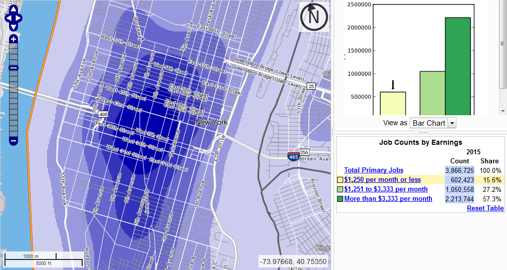
There are workplaces where most employees are high-income, for example office towers (or office parks) hosting tech firms, law firms, or banks. There are workplaces where most employees are working-class, for example factories, warehouses, and farms. Does this lead to a difference in commuting patterns by class? I fired up OnTheMap two days ago and investigated. This is American data, so it stratifies workers by income, education, industry, or race rather than by job class. I generated maps for New York and saw the following:
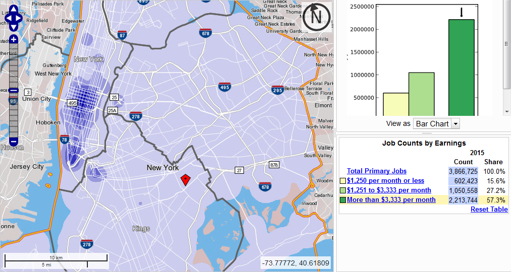
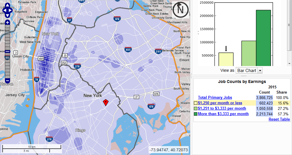
There are three income classes available, and I looked at the bottom and top ones, but the middle one, still skewed toward the working class, looks the same as the bottom class. The biggest observation is that Midtown is dominant regardless of income, but is more dominant for middle-class workers (more than $40,000 a year) than for low-income ones (up to $15,000, or for that matter $15,000-40,000).
The colors are relative, and the deepest shade of blue represents much more density for middle-class workers, even taking into account the fact that they outnumber under-$15,000 workers almost four to one. Among the lowest-income workers we see more work on Queens Boulevard and in Williamsburg, Flushing, and the Hub, but these remain tertiary workplaces at most. The only place outside Midtown, Lower Manhattan, or Downtown Brooklyn (which includes all city workers in Brooklyn due to how the tool works, so it looks denser than it is) that has even the third out of five colors for low-income workers is Columbia, where the low-income job density is one-third that of Midtown, and where there is also a concentration of middle-class workers.
The same pattern – job centers are basically the same, but there’s more concentration within the CBD for the rich – also appears if we look at individual neighborhoods. Here is the Upper East Side versus East Harlem:
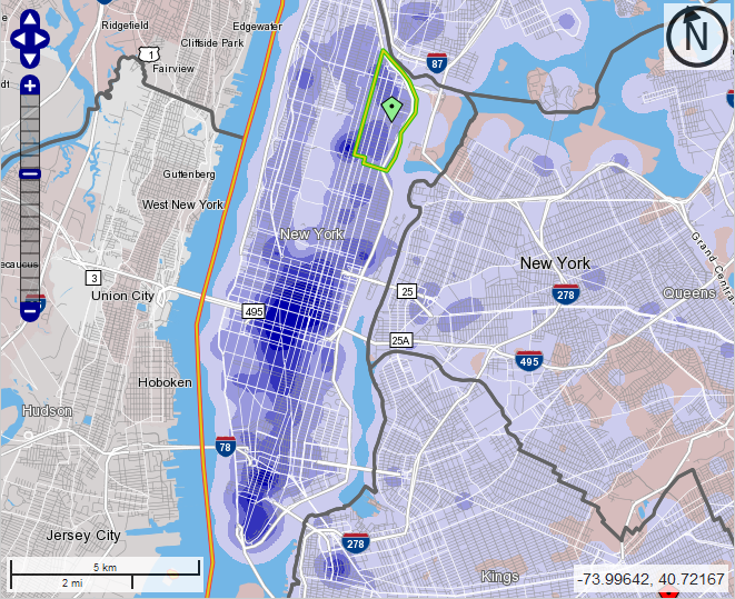
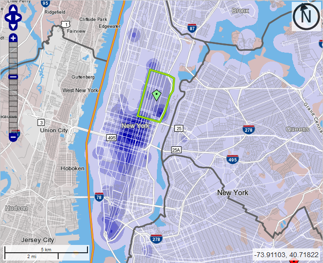
I chose these two neighborhoods to compare because they exhibit very large differences in average income and are on the same subway line. Potentially there could be a difference between where East Siders and West Siders work due to the difficulty of crosstown commuting, so I thought it would be best to compare different socioeconomic classes of people on the same line. With the East Side-only restriction, we see two Uptown job centers eclipse Columbia: Weill-Cornell Medical Center in Lenox Hill at the southeast corner of the Upper East Side, and Mount Sinai Hospital at the northwest corner.
One place where there is a bigger difference is the definition of Midtown. Looking at the general job distribution I’d always defined Midtown to range between 34th and 59th Street. However, there are noticeable differences by income:
For the middle class, Midtown ranges from 34th to 57th Street and peaks around 47th. For the lowest-income workers, it ranges from 28th to 49th and peaks in the high 30s. My best explanation for this is that Midtown South and Union Square are more retail hubs than office hubs, featuring department stores and shopping centers, where the rich spend money rather than earning it.
In a deindustrialized country like the US or France, the working class no longer works in manufacturing or logistics. There are a lot of truck drivers today – 3.5 million in the US – but in 1920 the American railroad industry peaked at 2.1 million employees (source, PDF-p. 15), nine times today’s total, in a country with one third the population it has today and much less mobility. Manufacturing has plummeted as a share of employment, and is decreasing even in industrial exporters like Germany and Sweden. Instead, most poor people work at places that also employ many high-skill, high-income workers, such as hospitals and universities, or at places where they serve high-income consumption, such as retail and airports.
Since the working class works right next to the middle class, the nature of bosses’ demands of workers has also changed. Low-skill works now involves far more emotional labor; in Singapore, which makes the modern-day boss-worker relationships more explicit than the Anglosphere proper, there are signs all over the airport reminding workers to smile more. Nobody cares if auto workers smile, but they’re no longer a large fraction of the working class.
With the working class employed right next to the middle class, there is also less difference in commuting. For the most part, the same transportation services that serve middle-class jobs also serve working-class jobs and vice versa. This remains true even across racially segregated communities. The patterns of white New York employment are similar to those of middle-class New York employment, and those of black, Hispanic, and Asian employment are similar to those of the working class, with small differences (Asians are somewhat more concentrated in Flushing, and blacks in Downtown Brooklyn, reflecting the fact that blacks are overrepresented in public employment in the US and all city workers in Brooklyn are counted at Court Square).
This is true provided that opportunities for transportation are available without class segregation. This is not the situation in New York today. Commuter rail actually serves working-class jobs better than middle-class jobs, since Penn Station is closer to the department stores of 34th Street than to the office towers in the 50s. However, it’s priced for the middle class, forcing the working class to take slower buses and subway trains.
When I posted the above maps on Twitter, Stephen Smith chimed in saying that, look, the poor are less likely to work in the CBD than the middle class, so everywhere-to-everywhere public transportation is especially useful for them. While Stephen’s conclusion is correct, it is not supported by this specific data. In the $40,000 and up category, 57% of city jobs are in Manhattan south of 60th Street, compared with 37% in the $15,000-40,000 and under-$15,000 categories. It’s a noticeable difference, but not an enormous one. The reason Stephen is correct about how rides crosstown transit is different: people who can afford cars are very likely to drive if the transit option is not good (which it isn’t today), whereas people who can’t are stuck riding slow crosstown buses; in contrast, for CBD-bound commutes, the subway and commuter rail work reasonably well (especially at rush hour) and driving is awful.
Instead of trying to look specifically at low-income and middle- and high-income job centers, it’s better to just plan transit based on general commute patterns, and let anyone take any train or bus. This doesn’t mean business as usual, since it requires transitioning to full fare integration. Nor does this mean ignoring residential segregation by income, which in some cases can lead to transit segregation even in the face of fare integration (for example, the crosstown buses between the Upper East Side and Upper West Side have mostly white, mostly middle-class riders). Finally, this doesn’t mean relying on middle-class transit use patterns as a universal use case, since the middle class drives in the off-hours or to off-CBD locations; it means that relying on middle-class transportation needs could be reasonable. It just means that the rich and poor have substantially the same destinations.
An even bigger implication relates to questions of redevelopment. There have been periodic complaints from the left about gentrification of jobs, in which working-class job sites are turned over to high-end office and retail complexes. For example, Canary Wharf used to be the West India Docks. In New York, Jane Jacobs’ last piece of writing before she died was a criticism of Greenpoint rezoning, in which she specifically talked up the importance of keeping industrial jobs for the working class. But since the big deindustrialization wave, developments brought about by urban renewal, gentrification, and industrial redevelopment have not had any bias against providing employment for the poor. It’s not the factory jobs that the unionized working class still culturally defines itself by, but it’s industries that are hungry for low-skill work, and in many cases are serious target of unionization drives (such as universities).
When are Express Trains Warranted? Part 2: Subways
Last week, I wrote about which regional rail lines should run local and express trains and which should only run locals. I gave various guidelines, specific to that mode of transportation. The same question makes a lot of sense for subways (or elevated lines), and is especially important for large cities building new metro networks, typically in developing countries. The key difference is that subway trains almost always run so frequently that the only way to have local and express services is to build four-track mainlines, like in New York. So really, this is a question about when it’s useful to build four-track subways instead of two-track subways.
Costs
The cost of a four-track subway is higher than that of a two-track subway. However, the difference depends on the method of construction. Cut-and-cover four-track subways do not appear to be much more expensive than two-track subways; in the 1900s, New York had little to no cost premium over London or Paris. The First Subway’s underground segments, slightly less than half of which are four-track, cost $39 million per km in today’s money, compared with about $29 million per km in Paris in the same era (see sources in this post). The Metropolitan line in London cost about the same: £1.3 million for 6 km in the early 1860s, or about $30 million per km.
In contrast, boring four tracks appears to cost twice as much as boring two. It’s hard to find examples, since four-track bores are extremely rare; the examples I do know, such as the East River Tunnels and the tunnel carrying the Lexington Avenue Line under the Harlem River, are short. There are bound to be efficiencies in engineering and sitework reducing the cost of boring, just as there are with cut-and-cover, but the majority of the cost of tunneling is the boring and the systems. The majority of the rest is stations, and the local stations can be built for not much of a premium over stations on a two-track line, but the express stations require considerably more excavation.
What this means is that cities that build cut-and-cover should probably aim to build four tracks rather than two. In retrospect, Paris should have built Metro Line 1 with four tracks: the narrowest street segment, Rue de Rivoli, runs for 3 km and is about 20-23 meters wide, which can take four tracks if there are only local platforms, and everything else is at least 30 meters and could take four tracks and express platforms. The only express station under Rivoli would probably be Chatelet, where there is a wide square where the station footprint could expand.
The question of whether to use cut-and-cover today is a separate issue. It’s easier for the first few lines than for subsequent lines, which have to cross under the old lines. Nonetheless, it’s still in use, for example in China; the lack of express tracks on Chinese subways has led to criticism on some railfan forums, particularly by Japanese railfans, who are used to the fast express trains of the JRs through urban areas. But in India, the longest underground segment in Delhi, on the Yellow Line, appears to be bored, running deep under Old Delhi. The one potential pitfall is that bored tunnels, while generally more expensive to construct than cut-and-cover tunnels if wide streets are available, are nimbler, making it easier to build lines to high standards, with wide curves.
Benefits
The two obvious benefits of express subways are speed and capacity. New York averages a decent speed, just under 30 km/h, buoyed by express trains that average about 36 km/h. When frequency on both the local and express tracks is adequate, which it regrettably isn’t most of the time in New York, it’s possible to use cross-platform local/express transfers to improve trip times even for people on the local stations.
The capacity benefits are sometimes compromised by transfers. In New York, the express tracks are consistently more crowded than the local tracks on the main lines, and the Upper West Side in particular sees the city’s most overcrowded trains on the express tracks run alongside the second least crowded on the local tracks. However, on the East Side, the local and express trains under Lexington are both quite full. The number of passengers they carry would overwhelm any two-track line: to carry the same number of passengers on just two tracks at the current peak frequency, each train would need about 2,100 passengers, more per unit of train floor area than the most crowded Tokyo Metro lines.
There are also indirect effect of four-tracking. The most distant stations are presumably express-only, or, if not, passengers will transfer to an express train at the first opportunity. This means that adding local stops does not increase trip times for passengers far out, which in turn argues in favor of tighter stop spacing on local trains, to provide more coverage. Evidently, New York has one of the smallest interstations (on local trains) of any major metro network in the world, surpassed only by Paris, which built the Metro without regard for the suburbs. Second Avenue Subway, built with just two tracks, has wider stop spacing than other Manhattan north-south mainlines, missing 79th Street, with the planned phase 2 stopping at 106th instead of 103rd and 110th.
Network effects
I have hammered repeatedly that metro systems need to avoid three pitfalls of network planning:
- Tangential lines, starting as radial farther out but becoming circumferential closer in rather than staying radial and serving city center.
- Reverse-branching: a common trunk in an outlying area splitting into branches in city center, the opposite of the more normal branching arrangement.
- Missed connections, in which two lines intersect without a transfer.
It is easier to miss connections when the stop spacing is wider, because city centers are so small that line 1 can easily miss the road that line 6 will later run under. The Paris Metro has just one missed connection (M5/M14), and the city made a failed effort in the 1900s to bring Line 5 to what would be the transfer station, Gare de Lyon. New York has only two missed connections among the lines built from 1900 to the 1920s (Junius/Livonia on the 3/L, Bowling Green/Whitehall on the 4-5/RW), both of which are easy to fix; the city’s tens of misses come from a deliberate decision to avoid transfers in the lines built in the 1930s. Systems with wider stop spacing have more opportunities for missed connections, such as Tokyo, Shanghai, and Moscow.
Four-track mainlines short-circuit this problem doubly. First, fewer lines are required to provide the same coverage and capacity. On the eve of the Great Depression, New York had six subway mainlines, three with four tracks and three with two, and 2 billion annual riders. Even if a city insists that all transfer stations be express (which is the case in New York among lines built before the 1930s, though at one station express platforms were only retrofitted decades later), there are fewer potential intersections; at city center, even the express lines are unlikely to have very wide stop spacing.
Moreover, it’s fine to miss transfers on express lines. The reason missed connections are so bad is that the alternative option typically requires a three-seat ride. For example, the 1 passes between Columbus Circle-59th Street and 50th Street without a connection to the E train, leaving connecting passengers with one of two options: ride to Times Square and transfer there, which is both a detour and a very long walk between the platforms, or change to the B or D at 59th and then again to the E at 53rd; the latter option is the faster one, saving about 5 minutes of in-vehicle time and 3 minutes of transfer time.
But if one of the transfers is cross-platform, then a three-seat ride is less onerous. This is especially true if this transfer is local/express on a long shared trunk line, where the transfer stations usually don’t get as crowded as between two separate trunks. This means that it’s possible, if there is no better option, to have local-only transfers. Two of the top stations in New York, 53rd/Lex and Columbus Circle, are local-only transfers.
Scale
Small cities don’t need to think about express trains very much. Transit cities with about 2 million people in their metro areas, such as Vienna, Stockholm, Prague, Budapest, and Hamburg, make do with a handful of metro lines, sometimes supplemented by regional rail. But as they grow, the number of urban rail lines they need grows to the point that a coherent two-track network is too difficult, not to mention too slow. Paris manages to make do with the RER acting as the express layer, but outside India and Pakistan, cities that are just beginning to build their metro networks don’t have large legacy commuter rail networks to leverage for express service. In Africa between the Sahara and South Africa, nearly everything has to be built from scratch, and the same is true of Bangladesh and much of Southeast Asia and Latin America.
Moreover, in developing countries, a large number of cities either are megacities or can expect to grow to that size class soon. This is less true in Latin America, nearly all of which has at- or below-replacement birth rates, already high urbanization rates, and negative net migration (thus, the main case for four-track subways in Bogota hinges on the fact that the city has absurdly wide roads for cut-and-cover, not on future scale). However, in poor countries with high birth rates and low urbanization rates, cities can expect to increase their population many times over in the next few decades. Lagos and Dhaka are already huge, and midsize cities such as Nairobi, Kampala, Dar es Salaam, Addis Ababa, Khartoum, Accra, Abidjan, Douala, and Sanaa can expect to grow to that size class within a generation, as can midsize cities in countries with lower birth rates, such as Chittagong, Hanoi, and Ho Chi Minh City. In such cities, transportation planning should presume much greater scale than may seem warranted today.
A smaller-scale version of this principle can be found in cities that are growing rapidly due to immigration, especially Singapore but also Sydney, Melbourne, Toronto, Vancouver, and Stockholm. Such cities might want to consider infrastructure investments based not on their present-day population levels, but on those that they can expect after 30 more years of high migration rates. Vancouver and Stockholm are too small for express subways no matter what, and Toronto has already built its central spines with two tracks (and is upgrading its regional rail network to act as an express layer), but Singapore, Sydney, and Melbourne should all think about how to plan for the possibility that they will have 10 million people within 50 years.
The MTA’s Bus Redesign Plan
Two weeks ago I wrote about the Brooklyn bus redesign I’m working on with Eric Goldwyn. The MTA, which is aware of our efforts, came up with its own plan. So far details are scant; there is a presentation available online, which talks about goals (“network redesign,” “higher frequency”) but no specifics (“a more gridded network,” “6-minute off-peak frequency on the main routes”).
At least so far, the goals seem solid. The MTA has the following list of improvements:
- Redesign the network from top to bottom based on customer input, demographic changes, and travel demand analysis. Provide better connectivity and more direct service in every neighborhood
- Optimize the existing network with community consultation by removing closely-spaced and underutilized stops and making street design changes on select corridors in coordination with NYC DOT
- Expand off-peak service on strategic routes using a toolbox of service strategies including increased frequency and demand based service adjustments
- Expand Traffic Signal Priority (TSP) to allow an approaching bus to hold a green light or shorten a red light
- Seek exclusive busways on priority corridors to give buses full access in major congested areas
- Identify opportunities for new bus lanes and queue jumps in 2018
- Advocate for strengthened NYPD enforcement of bus lanes to keep bus stops and travel lanes clear throughout the system
- Recommend dedicated transit-priority traffic teams to focus enforcement in key areas to ensure buses move quickly through trouble spots
- Use Bus Lane Enforcement Cameras mounted on buses to automatically identify violations and issue tickets. Advocate for legislation to expand beyond the existing 16 authorized routes
- Install tap readers to speed up the boarding process so buses spend less time waiting at stops
- Introduce all-door boarding to allow riders to get on through any door of the bus
- Explore options for a future cashless system to maximize reductions in boarding time
- Expand fare enforcement on regular bus service to reduce evasion and restore fare revenue
The main problems only appear toward the end, with the implementation of off-board fare collection and all-door boarding. The insistence on “fare enforcement,” which could mean regular proof of payment (POP) inspections but could also mean worse, such as armed cops (not practiced in New York on SBS but practiced on some other US systems, like BART) or holding the bus during inspection (which New York does practice, unlike Berlin and other German-speaking cities). Overall I’m relatively sanguine about Andy Byford specifically – he’s not American and is not used to American levels of police militarization.
However, another aspect of the POP proposal is troubling: the connection with tap readers. The plan’s full text (which is barely more detailed than what I quote above) mentions that POP should come with the so-called New Fare Payment System, or NFPS, which New York is currently planning to roll out starting in 2019, continuing until 2023. The NFPS is based on worst industry practices cobbled from American and British ideas. Here is my second post ever, discussing the plans for smartcards in New York in 2011. New York ignored (and keeps ignoring) the smartcard implementations in a number of East Asian cities in its zeal to make people treat their credit card as a transit fare card, ensuring the agency can surveil all passengers; perhaps Americans lack the values of freedom and individual privacy of Japan and Singapore.
New York also ignored (and keeps ignoring) the POP implementations in cities with paper tickets, such as most of Central Europe. Smartcards are not required for POP: the German-speaking world has POP with paper tickets, as did Vancouver on SkyTrain and some bus lines even before the Compass Card debacle. In Singapore I saw a ticket inspection on a bus even before EZ-Link; I had a magnetic farecard at the time. Given the enormous waste coming from making passengers line up and pay the driver, it’s imperative to move toward POP as soon as possible, even if it means equipping inspectors with MetroCard readers rather than smartcard readers. MetroCard may only last for five years if the NFPS schedule doesn’t keep slipping, but handheld magnetic card readers are a cheap technology whereas making buses idle while passengers dip cards one at a time is not so cheap.
The zeal to go cash-free is the final troubling aspect of New York’s ideas about fare payment, especially when bundled with the idea that the bank card is the fare card. Not everyone has a local bank account. Tourists don’t (and even cards that are supposed to work abroad don’t always). Low-income city residents don’t, either: 11.7% of New York households have no bank account, and they disproportionately appear to be in poverty, judging by which neighborhoods they are most concentrated in. The MTA has always treated anonymous smartcards as an afterthought, and going cash-free means there is no recourse for the unbanked or even for many tourists.
Nor is cash-free operation even necessary. An on-board farebox is compatible with POP. In this system, riders can board from any door, and the driver will begin moving as soon as all passengers have boarded, even if not all passengers have paid yet. Riders with valid transfers or season passes need not do anything. Riders with a pay-per-ride smartcard and no transfer should tap their card at a validator at any bus door or bus stop (validators are cheap that blanketing the system with them is practically free). The remaining passengers should walk to the farebox and pay there; perhaps some busy stations should get fareboxes, as all SBS stops do in New York today, but if the MTA only expects a few smartcard-free, non-transfer passengers at a stop, then having them pay on board a moving bus should not be a problem.
I’d like to stress that other than the ongoing hiccups of the English-speaking world with fare payment systems (hiccups that it seems to export to Paris), the plan appears good, from what few details the MTA has released. There are plans for increasing the average distance between bus stops, adding more bus lanes, getting serious about signal preemption, raising off-peak frequency, and letting passengers board from all doors. The MTA really is noticing that its bus system is collapsing and really is making serious plans to avert a death spiral.
When are Express Trains Warranted? Part 1: Regional Rail
The Regional Plan Association has a detailed regional rail proposal out. It’s the same one from the Fourth Plan that I’ve criticized here, on Streetsblog, and on Curbed, but with more explanation for how the service should run, with stopping patterns and frequency.
There are some good aspects there, like a section about the importance of electrification and multiple-units, though it stops short of calling for full electrification and replacement of locomotives with EMUs; the focus on off-peak frequency is also welcome. There are also bad ones, like the claim on p. 32 that it’s difficult to impossible to provide through-running using the existing Penn Station tracks used by New Jersey Transit. Foster Nichols told me that there are some difficulties with grades but they should be doable if NJT commits to an all-EMU fleet, and reminded me that the ARC studies judged through-running using these station tracks and new tunnels feasible. What he expressed to me as a difficulty turned into a near-impossibility in the report, in order to justify the $7 billion Penn Station South project.
But I want to focus on one particularly bad aspect of the proposal: the stopping patterns. The RPA is proposing three distinct stopping patterns on pp. 32-45, with three separate brands: Metro, in the city and some inner suburbs; Regional Express (RX), in the suburbs; and Trans-Regional Limited (TRL), providing intercity service to New Haven, Ronkonkoma, Philadelphia, and other major stations outside the built-up area. Even as the plan talks about the importance of making sure suburban trains serve urban stations in order to give them frequent service through overlay, the stopping patterns suggest the opposite.
The proposal involves trains from the suburbs expressing through most city stations (including the infill) even on two-track lines, like the Port Washington Branch. Metro trains would make all current stops plus additional infill to Bayside, and RX trains would only serve Willets Point, Flushing, and Bayside, and then run from Bayside to Port Washington. A similar pattern happens from Jamaica to Valley Stream, resulting in the Babylon, Long Beach, and Far Rockaway Branches all having to share a track pair. Moreover, the RX trains may themselves be divided into local and express trains, for example on the New Haven Line.
This is bad practice. On a two-track line, there’s no real reason to skip a handful of inner stations just to guarantee the outer ones express service. If anything, the need to schedule trains on the same tracks would lead to more fragile timetables, requiring more schedule padding. My analysis from 2.5 years ago found that the LIRR Main Line is padded 32% and the Babylon Branch is padded 19%: that is, the scheduled travel time on the Main Line (up to Ronkonkoma) is 32% more than the travel time imputed from line speed limits and current fleet acceleration performance. Patrick O’Hara, who the RPA study even quotes as a source elsewhere, investigated this issue separately, looking at best-case timetables, and found that some runs are padded 40-50%.
In Switzerland, trains are padded 7%, and I’m told that in Japan, after the Amagasaki accident showcased the safety problems of overly precise schedules, pads are about 5%. Express trains and locals mixed on the same line make it harder to maintain tight enough reliability for low schedule padding; this way, on an all-local line, trip times may match those of express trains on mixed lines, as they do in my analysis above. The best analogy is the RER B going to the north: the express trains are 4 minutes faster than the local trains, skipping 9 stops. The stop penalty on the RER B is higher, closer to 7 minutes over 9 stops, but the shared tracks with local trains (and with the RER D between Gare du Nord and Chatelet-Les Halles) means that there’s a fudge factor in the schedule, so it’s not possible to reliably do better than 4 minutes, and the trains end up visibly crawling on the mainline.
The reader familiar with technical transit advocacy in the Bay Area may interject, what about Caltrain? Clem Tillier has no trouble proposing timetables mixing local trains, express trains, and high-speed rail on the same track pair with timed overtakes, and a 7% pad. So why am I down on this concept in New York? The answer is line complexity. Caltrain is a simple two-track back-and-forth, and HSR is generally more punctual than legacy trains because it runs for long stretches on high-quality dedicated tracks, so it’s unlikely to introduce new variability to the line. In contrast, the RPA plan for regional rail in New York involves extensive branching, so that train schedules depend on trains elsewhere on the line. In this case, introducing more complexity through local/express sharing is likely to require more schedule padding, erasing the speed advantage.
In general, my questions to establish guidelines for where express trains are warranted are,
- How long is the line, measured in the number of stations? More stations encourage more express trains, because more stations can be skipped. In higher speed zones, stop penalties are higher, but at equal line length measured in km, higher speeds and fewer local stations reduce the benefit of express trains.
- How frequent are trains? At low frequency, local stations need more frequency, so express runs are less useful. At very high frequency, there may not be capacity for different stopping patterns unless the line has four tracks. On a two-track line, the optimum frequency for a local/express alternation is about 6-12 trains per hour, 3-6 local and 3-6 express, with a single mid-line overtake. Multiple overtakes on a single line are possible, but more fragile, so they are a bad idea except in special circumstances.
- What is the demand for travel? Express trains work best if there are a few distinguished stations at regular intervals, or else if the line is long and there is strong demand at the far end; if the inner stations are very strong then it’s more important to give them higher local frequency. When performing this analysis, it’s important to make sure station ridership levels reflect genuine demand rather than service. For example, Caltrain express stops have high ridership in large part because of their better service, not nearby density, as shown in Clem Tillier’s analysis. The LIRR Main Line has far more ridership at Mineola and Hicksville than the other stations on the trunk and also far more service, but Patrick explains that this is due to better highway access, so it’s genuine demand and not just a reflection of better service.
Caltrain needs express service because it has about 20 stations between San Francisco and San Jose, depending on the amount of infill and anti-infill desired; a target frequency of 8-10 peak trains per hour; and strong demand on the outer stations, especially for reverse-peak trips. In New York, none of the two-track lines meets the same standard. Some are too short, such as the Port Washington Branch. Others are too busy, such as the Harlem Line, Babylon Branch, and LIRR Main Line. Yet others have too much demand clustering in the inner stations, such as the Erie lines and the North Jersey Coast Line.
On four-track lines, it’s always easier to run express service. This doesn’t mean it should always be run: the upper New Haven Line is a strong candidate for relegating all commuter trains to the local tracks, making all stops, giving the express tracks to intercity trains. The Northeast Corridor Line in New Jersey is a dicey example: past Rahway there are four tracks, but intercity trains could run at very high speeds, making track sharing on the express tracks difficult. My service pattern map has express trains skipping Edison and Metuchen, but it’s just two stations, making it better to just run local beyond Rahway to clear the express tracks for high-speed rail.
It’s tempting to draw proposals involving intense metro-style regional rail service only serving the urban and inner-suburban stations; I’ve had to argue against such plans on some MBTA lines. The problem is that trains from the outer suburbs are still necessary and still going to pass through the inner suburbs, and in most cases they might as well stop at those stations, which need the frequency more than the outer suburbs need the few minutes of speedup.
Buses in Brooklyn: Frequency is Freedom, but 15 Minutes isn’t Frequency
I’ve recently started working part-time on a project for the Marron Institute at NYU about bus restructuring in Brooklyn; at the end of this summer, I expect to release a proposal for service upgrades and a new map. I’m working on this with Marron scholar Eric Goldwyn, who is funded by the TWU, which is worried that ridership collapse may lead to service cuts and job losses, but I’m funded directly by Marron and not by the union.
Some of what’s likely to appear in the final report should be familiar to regular readers of this blog, or of Human Transit, or of the work TransitCenter has been doing. As I wrote in Curbed earlier this year, bus operating costs in New York are unusually high because the buses are slow, as the main operating costs of buses scale with service-hours and not service-km. Thus, it’s important to speed up the buses, which allows either providing higher frequency at the same cost or the same frequency at lower cost. A bus speedup should include systemwide off-board fare collection and all-door boarding (common in the German-speaking world but also in San Francisco), wider stop spacing, dedicated lanes wherever there is room, and signal priority at intersections; the TWU is an enthusiastic proponent of off-board fare collection, for reasons of driver safety rather than bus speed.
While bus speedups are critical, their impact is not as Earth-shattering as it might appear on paper. New York’s SBS routes have all of the above features except signal priority, and do save considerable time, but are still slow city buses at the end of the day. Brooklyn has two SBS routes: the B44 on Nostrand, averaging 15 km/h (local B44: 11.3), and the B46 on Utica, averaging 13.7 (local B46 on the shared stretch: 10.8). Their speed premiums over the local routes are toward the high end citywide, but are still 30%, not the 200% speed premium the subway enjoys. Moreover, the speed premium over non-SBS limited routes is 15-20%; put another way, between a third and a half of the speed premium comes purely from skipping some stops.
I mentioned in my last post that I met Carlos Daganzo at Berkeley. Daganzo was responsible for the Barcelona bus redesign, Nova Xarxa; you can read some details on Human Transit and follow links to the papers from there. The guiding principles, based on my conversation with Daganzo and on reading his papers on the subject, are,
- Barcelona has high, relatively uniform density of people and jobs, so there’s no need for buses to hit one CBD. Brooklyn has about the same average residential density as Barcelona, but has a prominent CBD at one corner, but as this CBD is amply served by the subway, it’s fine for buses to form a mesh within the subway’s gaps.
- Nova Xarxa involved widening the stop spacing in Barcelona from less than 200 meters to three stops per km, or a stop every 300-350 meters; Daganzo recommends even wider stop spacing.
- While Barcelona’s street network is strictly gridded, the buses don’t run straight along the grid, but rather detour to serve key destinations such as metro stops. This is an important consideration for Brooklyn, where there are several distinct grids, and where subway stops don’t always serve the same cross street, unlike in Manhattan, where crosstown routes on most two-way streets are assured to intersect every north-south subway line.
- The percentage of transfers skyrocketed after the network was implemented, standing at 26% at the end of 2015, with the model predicting eventual growth to 44%, up from 11% before the redesign.
- The network was simplified to have 28 trunk routes, the least frequent running every 8 minutes off-peak.
The high off-peak frequency in Barcelona is a notable departure from Jarrett Walker’s American network redesigns; the evidence in Houston appears mixed – ridership is about flat, compared with declines elsewhere in the country – but the percentage of transfers does not seem to have risen. Jarrett says in his book that having a bus come every 10 minutes means “almost show-up-and-go frequency” with no need to look at schedules, but his work in Houston and more recently in San Jose involves routes running every 15 minutes.
Moreover, unreliable traffic in these car-dominated cities, in which giving buses dedicated lanes is politically too difficult, means that the buses can’t reliably run on a schedule, so the buses do not run on a clockface schedule, instead aiming to maintain relatively even headways. (In contrast, in Vancouver, a less congested street network, with priority for all traffic on the east-west main streets on the West Side, ensures that the buses on Broadway and 4th Avenue do run on a fixed schedule, and the 4th Avenue buses have a 12-minute takt that I still remember four years after having left the city.)
I’ve talked about the importance of radial networks in my posts about scale-variant transit. I specifically mentioned the problem with the 15-minute standard as too loose; given a choice between an untimed 15-minute network and a timed 30-minute network, the latter may well be more flexible. However, if the buses come every 5 minutes, the situation changes profoundly. Daganzo’s ridership models have no transfer penalty or waiting penalty, since the buses come so frequently. The models the MTA uses in New York have a linear penalty, with passengers perceiving waiting or transferring time on the subway as equivalent to 1.75 times in-motion time; bus waiting is likely to be worse, since bus stops are exposed to the elements, but if the average wait time is 2.5 minutes then even with a hefty penalty it’s secondary to in-vehicle travel time (about 18 minutes on the average unlinked bus trip in New York).
Unfortunately, that high frequently does not exist on even a single bus line in Brooklyn. Here is a table I created from NYCT ridership figures and timetables, listing peak, reverse-peak, and midday frequencies. Five routes have better than 10-minute midday frequency: the B12, the B6 and B35 limited buses, and the B44 and B46 SBSes, running every 7, 7.5, 8, 8, and 6 minutes respectively. In addition, the B41 limited and B103 have a bus every 9 and 7.5 minutes respectively on their trunks, but the B41 branches on its outer end with 18-minute frequencies per branch and the B103 short-turns half the buses. Another 14 routes run every 10 minutes off-peak, counting locals and limiteds separately.
The problem comes from the split into local and limited runs on the busiest buses. The mixture of stopping patterns makes it impossible to have even headways; at the limited stops, the expected headway in the worst case is that of the more frequent of the two routes, often about 10 minutes. The average ridership-weighted speed of Brooklyn buses is 10.75 km/h. An able-bodied passenger walking at 6 km/h with a 10-minute head start over a bus can walk 2.25 km before being overtaken, which can easily grow to 3 km taking into account walking time to and from bus stops. To prevent such situations, it’s important to run buses much more frequently than every 10 minutes, with consistent stopping patterns.
This does not mean that NYCT should stop running limited buses. On the contrary: it should stop running locals. The SBS stop spacing, every 800 meters on the B44 and B46, is too wide, missing some crossing buses such as the B100 (see map). However, the spacing on the B35 limited is every 400 meters, enough to hit crossing buses even when they run on one-way pairs on widely-spaced avenues. The question of how much time is saved by skipping a stop is difficult – not only do different Brooklyn buses give different answers, all lower than in Manhattan, but also the B35 gives different answers in different directions. A time cost of 30 seconds per stop appears like a good placeholder, but is at the higher end for Brooklyn.
The question of how many stops to add to SBS on the B44 and B46 has several potential answers, at the tight end going down to 400 meters between stops. At 400 meters between stops, the B44 would average 13 km/h and the B46 12 km/h. At the wide end, the B44 and B46 would gain stops at major intersections: on the B44 this means Avenue Z, R, J, Beverly, Eastern Parkway, Dean, Halsey, and Myrtle, for an average interstation of 570 meters and an average speed of 14 km/h, and on the B46 this means Avenue U, Fillmore, St. John’s, and Dean, for an average interstation of 610 meters an average speed of 13 km/h. Consolidating all buses into the same stopping pattern permits about a bus every 2.5 minutes peak and every 4 minutes off-peak on both routes.
On the other routes, consolidating local and limited routes required tradeoffs and cannibalizing some peak frequency to serve the off-peak. While it may seem dangerous to limit peak capacity, there are two big banks that can be used to boost off-peak frequency: time savings from faster trips, and greater regularity from consolidating stop patterns. The B82 is an extremely peaky route, running 7 limited and 10 local buses at the peak and just 6 buses (all local) for a four-hour midday period; but there is a prolonged afternoon shoulder starting shortly after noon with another 6 limited buses. Some peak buses have to be more crowded than others just because of schedule irregularity coming from having two distinct stop patterns. Consolidating to about 15 buses per hour peak and 10 off-peak, cannibalizing some frequency from the peak and some from the shoulders, should be about neutral on service-hours without any additional increase in speed.
The sixth post on this blog, in 2011, linked to frequent maps of Brooklyn, Manhattan, and Bronx buses, using a 10-minute standard. There has been some movement in the top buses since 2011 – for one, the B41 route, once in the top 10 citywide, has crashed and is now 16th – but not so much that the old map is obsolete. A good place to start would be to get the top routes from a 10-minute standard to a 6-minute standard or better, using speed increases, rationalization of the edges of the network, and cannibalization of weak or subway-duplicating buses to boost frequency.
Joe Lhota Admits Defrauding the Public About Costs
The Wall Street Journal is reporting a bombshell story about New York’s subway station renovation program. The MTA had a budget of $936 million for renovating 32 subway stations, but nearly the entire budget is exhausted after the MTA has spent it on only 19 stations. These renovations do not include accessibility, which New York is lagging on. I’m interviewing people in the disability rights community about New York’s problems in this area, but the smoking gun about Lhota is not that issue, on which he is no worse than anyone else. Rather, it’s that Lhota hid the fact of the cost overrun from the MTA board. Per the Journal:
On Monday, Carl Weisbrod, a commissioner who represents New York City, said the program was “ill-conceived,” and that he is glad it has come to an end.
“I don’t know when the MTA management realized that the program had run out of money but it would’ve been helpful to have informed the board when this matter was under discussion,” he said.
Mr. Lhota said he was aware of the increased costs last year, but he chose not to mention it until now. “I didn’t think it was relevant to the debate,” he said.
An alternative way to phrase Lhota’s own words is that he is concealing critical information from the public relevant to public spending priorities. In other words, he is defrauding the public when it comes to costs. Previously he had been merely making excuses for high construction costs (e.g. saying New York, founded in the 17th century, is old, and thus naturally has higher costs than cities founded in the Middle Ages or even in Antiquity). But now it turns out that he’s not only trying to deflect criticism, but is actively putting obstacles in front of board members, journalists, and ordinary citizens who want to discuss MTA capital expansion.
Absent democratic mechanisms for oversight of the state, the state will not engage in cost-effective projects. We know this, because the part of public policy most insulated from public criticism, the military and security in general, is the most bloated. The US is wasting a trillion and a half dollars on the F-35, and allies like Israel are wasting money buying this jet from the US military industry. It’s hard to question the costs when overconfident military commanders say “this is necessary for national security.” The intelligence community is even worse, with self-serving slogans like “our successes are private and our failures are public.”
Evidently, facing criticism over costs, domestic agencies portray their projects as necessary rather than useful, hence the weak claims that Gateway is required to avoid shutting down rail service across the Hudson. My specific criticism of the argument that Gateway is required is that the study recommending long-term shutdowns of the existing tunnels did not even attempt to provide a comparative cost of maintaining the tunnels on nights and weekends as is done today. An informed public can more easily demand an end to bad investments, and specific interest groups can highlight how they are harmed by bad spending: the Journal article mentions disability rights advocates demanding that the MTA instead spend money on putting elevators at stations to make them accessible to people in wheelchairs.
The station renovations are especially at risk of being canceled if an informed public finds their costs offensive. The benefits include better maintenance standards, but those are almost self-evidently useful but not necessary. Activists can complain about costs or demand that the money be spent elsewhere.
In Astoria, activists complain that the MTA is renovating stations at a cost of $40 million per station without even installing elevators for accessibility. In London, the cost of the Step-Free Access program is £200 million for 13 stations, or about $20 million per station, and in Paris, where only Metro Line 14 and the RER A and B are accessible, disability rights activists estimate the cost of making the remaining 300 stations accessible at €4-6 billion. This is profoundly different from the situation with tunneling costs, where London has a large premium over Paris and New York has a large premium over London. It is likely that New York can install elevators at the same cost of its top two European peers if it puts its mind to it.
However, such investments are not possible under the current leadership. If a hack like Lhota stays in charge of the MTA, there is not going to be transparency about contracting and about costs, which means that small overruns can blow out of proportion before anyone notices. In such an environment, high costs are not surprising. If New York State is interested in good, cost-effective transit, it will get rid of Lhota and replace him with an experienced transit manager with a good history regarding cost control and respect for the democratic process.
New York-Area Governments to Form a Coordinated Transportation Planning Agency
Governors Andrew Cuomo (D-NY) and Phil Murphy (D-NJ) announced that they would cooperate to form a Lower Hudson Transportation Association, or LHTA, to supersede what they described as antiquated 20th-century thinking and bring the region’s transportation into the 21st century. LHTA would absorb the transportation functions of Port Authority, which senior New York state officials speaking on condition of anonymity called “irredeemably corrupt,” and coordinate planning across the region. Negotiations with the state of Connecticut are ongoing; according to planners in New Jersey, the timing for the announcement was intended to reassure people that despite the lack of federal funding for Gateway, a lower-cost modified version of the project would go forward.
But the first order of business for LHTA is not Gateway. The governors’ announcement mentioned that LHTA would begin by integrating the schedules and fares throughout the region. By 2019, passengers will be able to transfer between the New York City Subway and PATH for free, and connect from the subway to the AirTrain JFK paying only incremental fare. Engineering studies for removing the false walls between PATH and F and M subway platforms are about to begin.
Commuter rail fare integration is also on the table. Currently, the fare on the subway is a flat $2.75. On commuter rail, it is higher even within New York City: a trip between Jamaica Station and New York Penn Station, both served by the E line of the subway, is $10.25 peak or $7.50 off-peak on the Long Island Railroad (LIRR). The governors announced that they would follow the lead of European transportation associations, such as Ile-de-France Mobilités in Paris, and eliminate this discrepancy under LHTA governance, which also includes revenue sharing across agencies. Detailed studies are ongoing, but in 2019, LHTA will cut commuter rail fares within New York City and several inner cities within New Jersey, including Newark, to be the same as the subway fare, with free transfers.
Simultaneously, LHTA will develop a plan for schedule integration, coordinating New Jersey Transit, the LIRR, Metro-North, and suburban bus agencies. In order to make it easier for suburban passengers to reach commuter rail stations, the suburban buses will be timed to just meet the commuter trains, with a single ticket valid for the entire journey. Today most passengers in the suburbs drive to the commuter rail stations, but the most desirable park-and-rides are full. Moreover, the states would like to redevelop some of the park-and-rides as transit-oriented development, building dense housing and retail right next to the stations in order to encourage more ridership.
Moreover, the LIRR and New Jersey Transit’s commuter trains currently stub-end at Penn Station in opposite directions. LHTA is studying French and German models for through-running, in which trains from one suburb run through to the other instead of terminating at city center. Planners within several agencies explain that the systems on the Long Island and New Jersey side are currently incompatible – for example, LIRR trains are electrified with a third rail whereas New Jersey Transit trains are electrified with high-voltage catenary – but reorganizing these systems for compatibility can be done in a few years, well before the Gateway project opens.
In response to a question about the cost of this reorganization, one of the planners cited the Swiss slogan, “electronics before concrete.” Per the planner, electronics include systems, electrification, and software, all of which are quite cheap to install, whereas pouring concrete on new tunnels and viaducts is costly. The planner gave the example of resignaling on the subway: the New York Times pegged the cost of modernizing subway signals at $20 billion, and this could increase capacity on most lines by 25 to 50 percent. But the cost of building the entire subway from scratch at today’s costs in New York is likely to run up to $200 billion.
But while the immediate priorities involve fare and schedule integration, LHTA’s main focus is the Gateway project. There are only two commuter rail tracks between New Jersey and Penn Station, and they are full, running a train every 2.5 minutes at rush hour. The Gateway project would add two more tracks, doubling capacity. The currently projected cost for the tunnel is $13 billion, but sources within New York said that this number can be brought down significantly through better coordination between the agencies involved. This way, it could be funded entirely out of local and state contributions, which add up to $5.5 billion. When pressed on this matter, officials and planners refused to say outright whether they expect $5.5 billion to be enough to cover the tunnel, but some made remarks suggesting it would be plausible.
Previous estimates for the costs of Gateway adding up to $30 billion include substantial extra scope that is not necessary. Sources on both sides of the Hudson report that the main impetus for the formation of LHTA was to coordinate schedules in a way that would make this extra scope no longer necessary. “With last decade’s ARC, there was a cavern under Penn Station to let trains reverse direction and go back to New Jersey,” explains one of the planners; ARC was a separate attempt to add tracks to the Hudson rail crossing to Penn Station, which Republican Governor Chris Christie canceled in 2010 shortly after his election. “With Gateway, there was the plan for Penn Station South, condemning an entire Manhattan block for the station for $7 billion. With the plans we’re developing with LHTA we don’t need either Penn South or a cavern to let trains run between stations.”
Moreover, some planners suggested reactivating plans to connect Penn Station and Grand Central as part of Gateway. They refused to name a cost estimate, but suggested that at the low end it could be funded out of already-committed state money. Under this plan, there would be through-running between not just New Jersey Transit and the LIRR but also Metro-North, serving the northern suburbs of New York and Connecticut. Sources at the Connecticut Department of Transportation said they are studying the plan and have reservations but are overall positive about it, matching the reports of sources within New York, who believe that Connecticut DOT will join LHTA within six months.
Officials are optimistic about the effects of LHTA on the region both privately and publicly. The joint press release referred to the metro area as “a single region, in which decisions made in far apart areas of New York nonetheless affect people in New Jersey and vice versa.” Planners in both states cited examples of friends and family in the other state who they would visit more often if transportation options were better. With better regional rail integration, they said, people would take more trips, improving regional connectivity, and take fewer trips by car, reducing traffic congestion and pollution.
Job Sprawl in the US vs. Europe
Both American and European cities have prominent central business districts with high job density. But when jobs sprawl beyond the CBDs, they do so in very different manners on the two sides of the Pond, which is both a cause and an effect of higher US automobile usage. Much of this job sprawl happens in places that people on the other side of the Pond would not recognize as part of The City. Besides the obvious misunderstandings, this can compromise the quality of analysis of urbanism and the transportation required to serve it. In short, the European model, for which my models are Stockholm and Paris, is that jobs sprawl contiguously from the CBD, enlarging its physical area, whereas the North American model, for which my models are New York and Washington, is that jobs leap large swaths of residential neighborhoods into auto-oriented suburbia.
CBDs and job density
Office towers are rare in European CBDs. Paris is largely built up to 6 to 9 stories, and the higher end is more common in residential areas like Nation than in the CBD, which stretches from Les Halles to Saint-Lazare and Etoile. Stockholm has a total of five towers in its center, none especially tall. Contrary to the common European belief that high-rises don’t add density, the mid-rise character of most European CBDs leads to a real limit on their ability to agglomerate. The job-densest arrondissement of Paris, the 2nd, has 60,000 jobs in a square kilometer (look for table EMP T6 here); Midtown Manhattan has about 800,000 jobs in 4 square kilometers.
Not all jobs are in the CBD. Some are local community facilities, such as schools, supermarkets, and hospitals. But even more exportable jobs are not all in the CBD. Some industries cluster in sections of the CBD (such as advertising on Madison Avenue in New York or, traditionally, the media on Fleet Street in London), and similarly some cluster in off-CBD locations, perhaps near one firm that located idiosyncratically. In the other direction, not even the job density of Midtown can contain every workplace that wants a central location, and this pushes out firms that can’t compete for CBD office rents. The difference between the North American and European models is where these firms are likely to locate.
Contiguous sprawl
In both Paris and Stockholm, the solution to the restricted job density of their city centers is, superficially, high-rise clusters in a particular suburban place: La Defense in Paris, Kista in Stockholm. The job density at the center of La Defense is actually higher than in the 2nd arrondissement, though it drops drastically outside the very center, whereas the Paris CBD maintains a density of about 50,000 jobs per km^2 over 4 or 5 square kilometers. In both cases, this leads to spatial inequality: in Paris, the richest suburbs are in the west and southwest, and La Defense is west of the city; in Stockholm, Kista itself is surrounded by working- and middle-class areas, and the favored quarter is separated from it by a lake, but the ill-favored quarter to the south is the farthest away.
However, there is much more to Paris employment than the CBD and suburban office towers. Paris has a total of 1.8 million jobs, with only around one eighth to one sixth of them in the CBD. There are corporate headquarters in La Defense and a number of other suburbs on the RER, but there are job clusters all over the city. My arrondissement, the 12th, has 120,000 jobs in a little more than 6 square kilometers, giving it the same job density as is average for the city. According to OnTheMap, Upper Manhattan, defined to be north of East 96th and West 110th Streets, has 150,000 jobs in 19 square kilometers, and the Upper East and West Sides, defined to be north of 62nd Street so as to exclude Columbus Circle jobs, have a total of 175,000 jobs in 9 square kilometers. While the Upper East and West Sides hold their own, in large part thanks to the hospital cluster around Weill-Cornell, Upper Manhattan does not.
These clusters in Paris are everywhere. In my arrondissement the cluster in question is Bercy, home to the Ministry of Finance; there’s also the university cluster in the Latin Quarter, an under-construction judicial cluster around Clichy-Batignolles, and high-end professional services spillover west of the CBD in the 16th and 17th arrondissements. In effect, office uses are sprawling into otherwise-residential neighborhoods.
In Stockholm, the same situation occurs. Spotify is headquartered two T-Bana stops north of T-Centralen, a short walk from where I used to live in Roslagstull (in fact, one of the people viewing my apartment as I was leaving it worked there). There’s also a prominent peak travel flow of students heading to KTH and the University on the trains from points south. In the south, Södermalm has its own secondary CBD around Slussen, the second busiest T-Bana station after T-Centralen.
Office park sprawl
North American cities do not have high overall job density in the core when one counts both the CBD and surrounding inner neighborhoods, which are typically entirely bedroom communities like Upper Manhattan. Instead, there is discontinuous job sprawl: jobs hop over residential areas into farther-away places, typically suburban office parks. The most famous in American urbanist discourse is Tysons Corner in Northern Virginia, but the Washington metropolitan area is generally replete with edge cities, including Reston, Bethesda, and Silver Spring, all located in the northern and western favored quarters of the region. Kista is really a high-rise version of these edge cities.
Washington is the purest example of office job sprawl. However, even there, there is a complication: there are some nearer job clusters like the Pentagon. New York and other large American cities are the same, with even more complications like this. In New York, the in-state side of the metro area has large suburban job clusters such as White Plains and Stamford, but the New Jersey side includes the formerly independent Downtown Newark, contiguous job sprawl in Jersey City directly facing Lower Manhattan, and very decentralized job sprawl in Middlesex County, contrasting with the centralized office sprawl of White Plains.
Robert Lang and Jennifer Lefurgy call Central Jersey edgeless cities and White Plains and Tysons edge cities. While edge cities exist in Europe, edgeless cities do not. Exurban retail in France resembles American exurban retail, with Carrefour inventing the hypermarket at the same time Wal-Mart did, but there is almost no equivalent of the small American office park. The closest I am aware of, Sophia-Antipolis, is an edge city with a large concentration of jobs, just built at automobile scale without any walkability.
New York is large enough to have an intermediate form: namely, a secondary CBD that’s not contiguous with the main city center. Downtown Brooklyn arose as such a CBD, serving Brooklyn, even though it’s contiguous with Lower Manhattan across the water. Jamaica is the best example, as it is quite far from Manhattan. La Defense should be put in this category as well – it is contiguous with the dense built-up area, if not with the CBD itself, and it is closer to Les Halles than Jamaica is to Midtown.
Favored quarters
There are multiple instances of large American firms moving their entire headquarters to be close to where the CEO lives. IBM moved to Armonk and General Electric moved to Fairfield, both leaving New York, to avoid making executives drive in Manhattan traffic. In Europe, too, the edge cities tend to be in rich areas. The corporate headquarters around Paris cluster in La Defense and to a lesser extent northwestern and southern suburbs, and not in Seine-Saint-Denis.
This is a straightforward consequence of the fact that rich Americans left city centers starting in the early 20th century, culminating in middle-class white flight in the 1950s, whereas Paris and Stockholm remain richer than their suburbs. The inhabitants of the 16th arrondissement of Paris are unlikely to be interested in job sprawl. Instead, the Paris CBD is slowly migrating westward, as retail and office rents at the western end (Etoile) are higher than in the center (the Opera) and eastern end (just west of Les Halles).
One would suspect that in American cities that are richer than their suburbs, the phenomenon of job sprawl would not occur. The problem is that there is no clean example today. Boston is still poorer than its suburbs; Cambridge is quite rich, but is functionally one favored-quarter wedge. San Francisco is overall richer than most of its suburbs, but really the entire strip of land from San Francisco down to San Jose is rich, and at any rate Silicon Valley formed in a then-independent metro region, rather than sprawling out of the center the way White Plains and Tysons Corner did.
However, as white flight is giving way to gentrification, and American cities are economically outgrowing their suburbs, this theory would predict that job sprawl should decrease, with more corporate jobs shifting back to the cities. This seems to indeed be happening: General Electric moved from Fairfield to Downtown Boston, and United-Continental moved its headquarters to the Sears Tower in the Chicago Loop; Aaron Renn periodically talks about the resorting of the American economy, in which the highest-end jobs are back to city centers whereas lower-end jobs are in the suburbs and smaller cities.
Is the US Europeanizing?
There is some evidence to suggest that American cities not only are reducing the extent of job sprawl in the highest pay categories, but also adopting the European pattern of contiguous CBD sprawl. This process is haphazard, and many urban boosters overrate the extent to which near-CBD locations like the West Loop in Chicago or the Seaport in Boston are attracting jobs, but these areas are nonetheless growing.
Boston is perhaps the best example of this trend. Locally, urban boosters anxiously talk about transportation connections to the Seaport, but the biggest action is happening in the other direction. Kendall Square is growing as the Cambridge CBD, with a cluster of tech firms, two stops out on the subway from the central transfer points. Boston is unique that Back Bay is a nearly-contiguous secondary CBD as well, based on extensive postwar urban renewal next to a rich residential neighborhood. This situation is especially notable given that both Cambridge and the Seaport are separated from the CBD by water, with unpleasant walking environments on the bridges, making the organic process of CBD extension more difficult.
Outside Boston, several more examples are notable. In San Francisco, tech jobs within the city cluster not in the Financial District but in the adjacent South of Market (“SoMa”) area. In Chicago, in addition to some growth in the West Loop, there is some job growth on the Near North Side. In New York, the tech jobs cluster in the Meatpacking District: the Google building, which I believe is the second largest Google office after the Googleplex, occupies the block between 8th and 9th Avenues and 15th and 16th Streets. But even before Google, there was growth in adjacent secondary CBDs across the water: Jersey City and Long Island City. Lang and Lefurgy’s writeup on edgeless cities classifies Jersey City as a secondary CBD rather than an edge city because “its context is old”: it’s built out of a near-CBD residential and industrial area, rather than developed from scratch near a road or rail intersection.
Starting last decade, urbanist writers in the United States noted that the US was Europeanizing in its pattern of rich cities and poor suburbs. Brookings was writing about suburbanization of poverty in 2010, describing a 2000-8 trend. The growth of near-CBD office clusters in Boston, New York, San Francisco, and Chicago suggests that the US is also Europeanizing in its pattern of how jobs spill over from the center. Instead of the traditional auto-oriented office park near the CEO’s residence, the highest-income, highest-prestige jobs in the US are decamping to the same near-CBD locations where they can be found in Paris or Stockholm, leaving the sprawl for the poor.
