Sometimes, Bus Stop Consolidation is Inappropriate
For the most part, the optimal average spacing between bus stops is 400-500 meters. North American transit agencies have standardized on a bus stop every 200-250 meters, so stop consolidation is usually a very good idea. But this is based on a model with specific inputs regarding travel behavior. In some circumstances, travel behavior is different, leading to different inputs, and then the model’s output will suggest a different optimum. In contrast with my and Eric’s proposal for harsh stop consolidation in Brooklyn, I would not recommend stop consolidation on the crosstown buses in Manhattan, and am skeptical of the utility of stop consolidation in Paris. In Vancouver I would recommend stop consolidation, but not on every route, not do we recommend equally sweeping changes on every single Brooklyn route.
The model for the optimal stop spacing
If demand along a line is isotropic, and the benefits of running buses more frequently due to higher in-vehicle speed are negligible, then the following formula holds:

The most important complicating assumption is that if demand is not isotropic, but instead every trip begins or ends at a distinguished location where there is certainly a stop, such as a subway connection, then the formula changes to,

The choice of which factor to use, 2 or 4, is not exogenous to the bus network. If the network encourages transferring, then connection points will become more prominent, making the higher factor more appropriate. Whether the network encourages interchanges depends on separate policies such as fare integration but also on the shape of the network, including bus frequency. Higher average bus speed permits higher frequency, which makes transferring easier. The model does not take the granularity of transfer ease into account, which would require a factor somewhere between 2 and 4 (and, really, additional factors for the impact of higher bus speed on frequency).
After the choice of factor, the most contentious variable is the walk speed and penalty. Models vary on both, and often they vary in directions that reinforce each other rather than canceling out (for example, certain disabilities reduce both walk speed and willingness to walk a minute longer to save a minute on a bus). In Carlos Daganzo’s textbook, the walk speed net of penalty is 1 m/s. For an able-bodied adult, the walk speed can exceed 1.5 m/s; penalties in models range from 1.75 (MTA) to 2 (a Dutch study) to 2.25 (MBTA). The lower end is probably more appropriate, since the penalty includes a wait penalty, and stop consolidation reduces waits even as it lengthens walk time.
Update 10/31: alert reader Colin Parker notes on social media that you can shoehorn the impact of walk time into the model relatively easily. The formula remains the same with one modification: the average trip distance is replaced with

The factor of 2 in the formula comes from computing average wait time; for worst-case wait time, remove the 2 (but then the wait penalty would need to be adjusted, since the wait penalty is partly an uncertainty penalty).
The average distance between buses is proportional to the number of service-hours, or fleet size: it obeys the formula

The factor of 2 in the formula comes from the fact that route-length is measured one-way whereas revenue hours are for a roundtrip.
If we incorporate wait time into the model this way, then the walk and wait penalties used should be higher, since we’re taking them into account; the Dutch study’s factor of 2 is more reasonable. The conclusions below are not really changed – the optima barely increase, and are unchanged even in the cases where stop consolidation is not recommended.
The situation in New York
The average unlinked New York City Transit bus trip is 3.35 km: compare passenger-miles and passenger trips as of 2016. In theory this number is endogenous to the transit network – longer interstations encourage passengers to take the bus more for long trips than for short trips – but in practice the SBS routes, denoted as bus rapid transit in the link, actually have slightly shorter average trip length than the rest. For all intents and purposes, this figure can be regarded as exogenous to stop spacing.
The stop penalty, judging by the difference between local and limited routes, is different for different routes. The range among the routes I have checked looks like 20-40 seconds. However, Eric tells me that in practice the B41, which on paper has a fairly large stop penalty, has little difference in trip times between the local and limited versions. The local-SBS schedule difference is consistent with a stop penalty of about 25 seconds, at least on the B44 and B46.
As a sanity check, in Vancouver the scheduled stop penalty on 4th Avenue is 22 seconds – the 84 makes 19 fewer stops than the 4 between Burrard and UBC and is 7 minutes faster – and the buses generally run on schedule. The actual penalty is a little higher, since the 4 has a lot of pro forma stops on the University Endowment Lands that almost never get any riders (and thus the bus doesn’t stop there). This is consistent with 25 seconds at a stop that the bus actually makes, or even a little more.
Plugging the numbers into the formula yields

if we assume everyone connects to the subway (or otherwise takes the bus to a distinguished stop), or

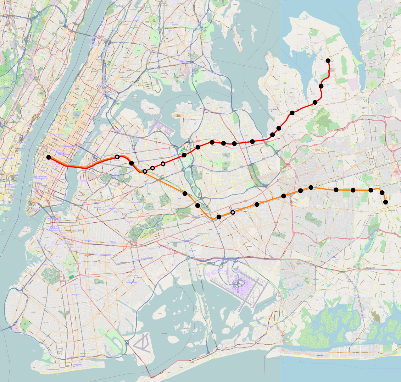
if we assume perfectly isotropic travel demand. In reality, a large share of bus riders are connecting to the subway, which can be seen in fare revenue, just $1.16 per unlinked bus trip compared with $1.91 per subway trip (linked or unlinked, only one swipe is needed). In Brooklyn, it appears that passengers not connecting to the subway disproportionately go to specific distinguished destinations, such as the hospitals, universities, and shopping centers, or Downtown Brooklyn, making the higher figure more justified. Thus, our proposed stop spacing, excluding the long nonstop segments across the Brooklyn-Battery Tunnel and between borough line and JFK, is 490 meters.
Update 10/31: if we incorporate wait time, then we need to figure out the average distance between buses. This, in turn, depends on network shape. Brooklyn today has 550 km of bus route in each direction, which we propose to cut to 350. With around 600 service hours per hour – more at the peak, less off-peak – we get an average distance between buses of 1,830 meters today or 1,180 under our proposal. Using our proposed network, and a wait and walk penalty of 2, we get

or

Short bus routes imply short stop spacing
Our analysis recommending 490 meter interstations in Brooklyn depends on the average features of New York’s bus network. The same analysis ports to most of the city. But in Manhattan, the situation is different in a key way: the crosstown buses are so short that the average trip length cannot possibly match city average.
Manhattan is not much wider than 3 km. Between First and West End Avenues the distance is 2.8 km. The likely average trip length is more than half the maximum, since the typical use case for the crosstown buses is travel between the Upper East Side and Upper West Side, but the dominant destinations are not at the ends of the line, but close to the middle. With Second Avenue Subway offering an attractive two-seat ride, there is less reason to take the crosstown buses to connect to the 1/2/3 (and indeed, the opening of the new line led to prominent drops in ridership on the M66, M72, M79, M86, and M96); the best subway connection point is now at Lexington Avenue, followed by Central Park West. On a long route, the location of the dominant stop is not too relevant, but on a short one, the average trip length is bounded by the distance between the dominant stop and the end of the line.
If we take the average trip length to be 1.6 km and plug it into the formula, we get

or

A crosstown bus stopping at First, Second, Third, Lex, Madison, Fifth, Central Park West, Columbus, Amsterdam, Broadway, and West End makes 10 stops in 2.8 km, for an average of 280 meters. There isn’t much room for stop consolidation. If the bus continues to Riverside, lengthening the trip to 3 km at the latitude of 96th Street, then it’s possible to drop West End. If the buses running up Third and down Lex are converted to two-way running, presumably on Lex for the subway connections, then Third could be dropped, but this would still leave the interstation at 330 meters, much tighter than anything we’re proposing in Brooklyn.
The only other places where avenues are too closely spaced are poor locations for stop removal. Amsterdam and Broadway are very close, but Amsterdam carries a northbound bus, and if the Columbus/Amsterdam one-way pair is turned into two two-way avenues, then Amsterdam is a better location for the bus than Columbus because it provides better service to the Far West Side. Fifth and Madison are very close as well, but the buses using them, the M1 through M4, are so busy (a total of 32 buses per hour at the peak) that if the two avenues are converted to two-way running then both should host frequent bus trunks. It’s not possible to skip either.
Within Brooklyn, there is one location in which the same issue of short bus routes applies: Coney Island. The B74 and B36 act as short-hop connectors from Coney Island the neighborhood to Coney Island the subway station. The routes we propose replacing them have 7 stops each from the subway connection west, over distances of 2.5 and 2.7 km respectively, for interstations of 360 and 390 meters.
Vancouver supplies two more examples of routes similar to the B74 and B36: the 5 and 6 buses, both connecting the West End with Downtown. The 6 is only 2 km between its western end and the Yaletown SkyTrain station, and the 5 is 2.3 km from the end to the Burrard station and 2.8 km to city center at Granville Street. The average trip length on these buses is necessarily short, which means that stop consolidation is not beneficial, unlike on the main grid routes outside Downtown.
Update 10/31: incorporating wait time into this calculation leads to the same general conclusion. The short routes in question – the Manhattan crosstowns, the B36 and B74, and the 5 and 6 in Vancouver – have high frequency, or in other words short distance between buses. For example, the M96 runs every 4 minutes peak, 6 off-peak, and takes 22-24 minutes one-way, for a total of 6 circulating buses per direction peak (which is 500 meters), or 4 off-peak (which is 750 meters). This yields

A network that discourages transferring should have more stops as well
In Paris the average interstation on buses in the city looks like 300 meters; this is not based on a citywide average but on looking at the few buses for which Wikipedia has data plus a few trunks on the map, which range from 250 to 370 meters between stations.
The short stop spacing in Paris is justified. First of all, the average bus trip in Paris is short: 2.33 km as of 2009 (source, PDF-p. 24). Parisian Metro coverage is so complete that the buses are not useful for long trips – Metro station access time is short enough that the trains overtake the buses on total trip time very quickly.
Second, there is little reason to transfer between buses here, or to transfer between buses and the Metro. The completeness of Metro coverage is such that buses are just not competitive unless they offer a one-seat ride where the Metro doesn’t. Another advantage of buses is that they are wheelchair-accessible, whereas the Metro is the single least accessible major urban rail network in the world, with nothing accessible to wheelchair users except Line 14 and the RER A and B. It goes without saying that people in wheelchairs are not transferring between the bus and the Metro (and even if they could, they’d have hefty transfer penalties). The New York City Subway has poor accessibility, but nearly all of the major stations are accessible, including the main bus transfer points, such as Brooklyn College and the Utica Avenue stop on the 3/4.
With little interchange and a mostly isotropic city density, the correct formula for the optimal bus stop spacing within Paris is

which is close to the midpoint of the range of interstations I have found looking at various routes.
Conclusion
The half-kilometer (or quarter-to-a-third-of-a-mile) rule for bus stop spacing is an empirical guideline. It is meant to describe average behavior in the average city. It is scale-invariant – the density of the city does not matter, only relative density does, and the size of the city only matters insofar as it may affect the average trip length. However, while scale itself does not lead to major changes from the guideline, special circumstances might.
If the geography of the city is such that bus trips are very short, then it’s correct to have closer stop spacing. This is the case for east-west travel in Manhattan. It is also common on buses that offer short-hop connections to the subway from a neighborhood just outside walking range, such as the B36 and B74 in Coney Island and the 5 and 6 in Vancouver’s West End.
Note that even in New York, with its 3.3 km average trip length, stop consolidation is still beneficial and necessary on most routes. North American transit agencies should not use this article as an excuse not to remove extraneous stops. But nor should they stick to a rigid stop spacing come what may; on some routes, encouraging very short trips (often 1.5 km or even less), closely spaced stations are correct, since passengers wouldn’t be riding for long enough for the gains from stop consolidation to accumulate.