Category: Good Transit
Quick Note: Heavy Touch and Control
There’s a distinction between light- and heavy-touch forms of management and control. Light-touch systems try to stay out of the details as far as they can; heavy-touch systems do the opposite. American business culture considers light touch to be superior, and I think this is especially prominent in the public sector, which has some ready-made examples of how the light touch approach works better – for example, in the military, it’s called mission command and is repeatedly shown to work better than more centralized command-and-control. Unfortunately, the same does not work for rail infrastructure. Why?
Heavy touch in infrastructure
In practice, a heavy-touch system in infrastructure construction, for example the way Germany, France, and Southern Europe work, has the following features:
- The state agency maintains control of designs, and even when it outsources something to consultants, it owns the product and may tweak it or assume that future contractors will tweak it. There is little privatization of planning.
- There is reluctance to devolve decisions to local governments; if SNCF or RENFE lets a regional government get involved in a rail plan, it’s because it’s an unprofitable regional line and the national railroad would rather not know it exists, and even DB happily unloads these same unprofitable regional lines on Land governments while focusing on intercity rail.
- Regulators are technical and make specific decisions.
This is not the only way to organize things, but it’s the only way that works. The Nordic countries have been moving away from this system in the last generation, influenced by British governing ideology; the sources I reference in the Stockholm case study repeatedly treat privatization as self-evidently good and exhort Nordic agencies to be more like the UK and less like Germany and Switzerland, and meanwhile, in the last 20 years Nordic costs have exploded while German ones have been fairly stable.
I’ve talked about the issue of privatization of the state to consultants many times, most recently a month ago. This post is about something different: it’s about how regulators work, an issue on which Sweden appears little different from Germany to me, and profoundly different from the United States and its can’t-do government.
American light touch elements
To understand how American regulations work, we need to look at the regulators and grant funders, that is, the Federal Transit Administration and Federal Railroad Administration, henceforth abbreviated FTA and FRA. How do they work?
- The chief regulators are never especially technical. The most sought after background, equivalent to a French grande école degree, is as far as I can tell a law degree from Yale. Engineers and planners always have to have a non-technical generalist watching over their shoulder, and this is the most prominent for the most politically sensitive projects.
- FTA/FRA reviewers are in some cases not even allowed to probe into the funding package they are to decide on. One of the biggest projects relevant to what we’ve studied at the Transit Costs Project and what I’ve written on this blog has a multi-billion dollar package, one that will almost certainly be only partially funded due to competing priorities, but the regulators are not allowed to see any itemized breakdown to see what partial funding would even do. Nor are regulators allowed to say which priorities to build first if there’s only partial funding.
- The higher regulators themselves believe that light-touch approaches are better and are reluctant to engage in any direct management – if they’d like to be more involved but are prohibited from doing so by the law or by constitutional interpretations, they have not said so.
- There is little churn between operations and regulations – in fact, this separation is treated as sacrosanct, even as in all other aspects the governing ideology calls for breaking down silos (and thereby disempowering specialists in favor of generalists). The contrast here is with Sweden, where state planners who worked on Citybanan, a state project, have since moved on to work for Stockholm County on the county-led Nya Tunnelbanan.
None of this works. The people who make the big decisions on funding in this system do not have the ability to make professional judgments, only political ones, and agencies know this and don’t bother with technical soundness.
Heavy touch and expertise
The connection between heavy touch and expertise is, you can’t manage things directly if you don’t have a lot of subject matter knowledge. In this sense, light touch may not necessarily be by itself bad, but rather, like design-build project delivery, it is in practice used to mask incompetence at the top level. The non-technical boss, who is in all but name a political commissar, can make vague proclamations, not get into details, and not feel like they’re out of their league and must defer to the engineer in the room.
Doing Projects Right and Doing the Right Project
I’d like to develop a distinction between two modes of success or failure in infrastructure projects, which I’ve mentioned in brief in past post. An infrastructure project may be done right or wrong – that is, it could be built at a reasonable lifecycle cost and offer high quality of service or it could fail to do this, typically through very high upfront construction costs with no future benefit. But it could also be the right project to build or the wrong one – that is it could be the right priority for the region that builds it based on expected usage and future development or it could be a low priority, typically due to politicization of engineering and planning. Those are distinct judgments, and I’m not even sure they are strongly correlated.
The right project, done wrong
I’ve mentioned in a few past posts as well as videos that New York is for the most part building the right projects right now. Based on any reasonable cost per rider calculation, the highest priorities in the region excluding mainline rail are Second Avenue Subway phases 1 and 2, an extension of phase 2 under 125th Street, subway extensions under Nostrand and Utica Avenues, an orbital line following the Bay Ridge Branch toward Jackson Heights and Yankee Stadium, and a subway extension to LaGuardia Airport. Phase 1 has been built, and the current priorities are phase 2 and the orbital line under the moniker IBX, the latter giving the governor’s personal imprimatur to this important project. The only lower-priority extension built ahead of these is the 7 extension to Hudson Yards, which is a small fraction of the good projects by total cost.
In mainline rail, on the New Jersey side, the biggest priority is the Gateway tunnel and this is indeed what the state and Port Authority are most invested in. Even on the New York side, mainline rail is invested in in roughly the right priority order, especially if one fixes the assumption of bad present-day operations; the only real problem is that due to politics from the late 1990s, the MTA overinvested in New York-side mainline rail (that is, East Side Access) to secure suburban Republican support for Second Avenue Subway phase 1.
The problem for New York is that every single project it touches is executed in almost the worst way possible. It can’t build, and to an extent it doesn’t even want to build. The $50 billion in New York-side capital investment every five years are a large multiple of what peer cities spend, and what this buys is a few kilometers of subway every decade, escalating maintenance costs, and a vague promise to not quite finish making the subway accessible in the 2050s. But the little it does build is, for the most part, the right project.
New York is not the only city in this situation. The prioritization in Toronto seems fine to me, including the Downtown Relief Line rebranded as the Ontario Line, electrification and general modernization of commuter rail as part of the RER project, and rail on Eglinton. London, likewise, seems to be building projects in the right priority order, but it lost its ability to build in the 1980s and 90s so that its urban rail growth rate is roughly one new line per monarch and its step-free access program is proceeding at a slower pace than that of any peer except New York (which can’t build anything) and Paris (which can and does but doesn’t believe in accessibility).
Wrong projects
In contrast with the example of New York or Toronto, there are places where the prioritization is completely out of whack. The best example I can give of is Los Angeles. Like New York and other English-speaking cities, Los Angeles can’t build; unlike New York, it clearly wants to build, and has a large expansion program based on two separate sales tax referenda, with lines programmed through the 2060s due to the extreme construction costs. However, the capital prioritization is just wrong, in several ways:
- The priority list puts low-usage extensions to the suburbs, like the Foothills Extension of the Gold Line and the West Santa Ana Branch, above core lines replacing high-usage buses like South Vermont and connectivity projects like linking Burbank and Pasadena directly.
- The suburban extensions often use the wrong mode or alignment – Los Angeles loves freeway medians for light rail rights-of-way, is building some lines parallel to or even in the right-of-way of commuter rail in lieu of improving Metrolink, and was starting to run into capacity problems on the shared street-running section of the Expo and Blue Lines before corona even on an otherwise low-intensity system.
- There is no transit-oriented development plan – the region is likely the NIMBY capital of the United States, and perhaps the developed world, with large swaths of valuable near-center land that’s about to get subway stations that’s still zoned single-family; in the state legislature, YIMBY bills increasing housing production typically get a large majority of the votes of politicians representing the Bay Area and a small minority of those representing the Los Angeles region.
- Much of the referendum money is not even rail expansion, but road programs, including new freeway lanes.
The upshot is that while New York builds the right projects wrong, Los Angeles builds the wrong projects, besides its issue of very high construction costs.
In reality, most places are on a spectrum, or even evolve from one to the other based on political changes. San Francisco built the almost totally useless Central Subway due to demands by people in Chinatown who don’t even ride public transportation; the line is so short and deep that even ignoring its construction costs, its trip time benefit over the buses it’s replacing is maybe 30 seconds. However, the future projects it wants to build but can’t due to high costs – the Downtown Extension tunnel taking Caltrain from its present near-center terminus to the actual city center and a second BART tube across the Bay with an extension under Geary – are exactly the right priorities, and would have long been built anywhere that could tunnel for $250 million/km and not $1 billion/km.
Boston, likewise, is building the right priorities at the level of what lines are visible on the map, but it has the second of Los Angeles’s four problems in droves. The Green Line Extension should have been commuter rail; the commuter rail electrification project should be all-catenary and not the current plan of a combination of catenary and experimental battery technology; the deelectrification of the trolleybuses was just embarrassing. But the actual alignments – the Green Line Extension, the planned Red-Blue Connector, and the Regional Rail project – are the right priorities, at least.
The wrong project, done right
So far I’ve given American examples of poor construction practices. But there are also examples of places that build effectively but have poor prioritization. My own city, Berlin, is the best example I can think of: its construction costs are pretty average – higher than in Southern Europe, lower than anywhere that uses international English-dominant consultants – but its project prioritization is terrible.
The obviously lowest-cost-per-rider extension, that of U8 to Märkisches Viertel (see some references linked here), has been deprioritized due to bad politicking. The Green Party and the heir to the East German communist party, Die Linke, both oppose subway construction on ideological grounds and prefer trams, the Greens because they associate subway construction with making room on the surface for cars and Die Linke for a combination of being used to East German trams and general wrecker politics. In the outgoing coalition, the pro-subway Social Democrats pushed for the lines that were the most important for its own priorities and those happen to be in Spandau and at the airport rather than Märkisches Viertel; thus, the U8 extension was placed behind those.
As with the American examples in the previous two sections, here we must qualify judgment in that it’s rather common for cities to be on a spectrum. Even Berlin has better project prioritization than Los Angeles: for one, it is not as NIMBY, and the U7 airport extension does come with a transit-oriented development plan.
A more typical example is perhaps Paris. Paris’s project prioritization raises some questions, but there is no obviously low-hanging fruit like U8 that remains unbuilt due to East Germany and 1970s New Left dead-enders. The current expansion plans underrate core capacity, by which I mean separating the RER B and D tunnels, currently shared between Gare du Nord and Châtelet-Les Halles; but such a project would be disruptive if highly beneficial, and another core capacity project, namely the expansion of the RER E through the city to La Défense and western suburbs, is proceeding. The outward expansion of the Métro seems to be largely in line with what the most important priorities are; Grand Paris Express is a mix of good lines, that is Métro Lines 14, 15, and 16, and bad that is Line 17 to the airport and Line 18 linking two rich suburbs with little density in-between.
Moreover, the Paris suburbs, where practically all expansion is done, are fairly YIMBY. Francilien housing production in the late 2010s was 80,000-90,000 a year (in 2019 it was 82,000, or 6.7/1,000 people), with virtually no construction in the city proper – and moreover, the housing built in the suburbs tends to be infill replacing disused industrial land, or else it’s on top of planned Grand Paris Express or RER stations.
Why?
The poor project prioritization in the cities I’ve given the most attention to – Los Angeles but also Berlin and San Francisco and glimpses of Paris and New York – is entirely about politics. As the worst city of the bunch, Los Angeles has illuminating features that we can use to judge the others.
In Southern California, the most significant misfeature is the statewide requirement that all tax increases be approved in a referendum by a two-thirds majority. In San Francisco, the electorate is so left-wing that this hurdle is not hard to clear, and agencies can plan as always. In Los Angeles and San Diego, it is not, and to secure enough votes, agencies have to essentially bribe clientelistic actors with specific lines on a map that those actors will never use but still take credit for. This leads to all of the following misfeatures:
- Ballot propositions that include not just expansion of the rail network but also subsidies to reduced fares for people with local New Left politics who identify politically against state planning, road expansion money for local notables who don’t mind rail expansion but think it’s too political to prioritize rail over cars, and long-term maintenance for unambitious bureaucrats who love spending that isn’t expected to produce concrete results.
- An expansion program that gives each subregion its own line – in Los Angeles, this is the Orange Line BRT for the Valley, the Gold Line for San Gabriel Valley, and so on; the core is a subregion in its own right and can get a project too, like the Regional Connector subway, but it can’t be expected to get too many projects, and interregional connections are less important since the regions they serve already have their lines.
- The planning is haphazard and avoids paradigmatic changes like modernizing the commuter rail system – Los Angeles has some advocates pushing for electrification, like Paul Dyson, and long-term plans to actually do it, but those plans are far behind what Caltrain electrification in the Bay Area (a perfect example of the right project done wrong) and what technical advocates are doing in Philadelphia and Boston.
In effect, a constitutional change intended to prevent California from wasting taxpayer money has had the opposite effect: the two-thirds majority requirement for tax hikes ensures that in Southern California, every petty actor is a veto point and therefore can get extra money. The New Left may comprise 1970s dead-enders trying and failing to reconcile their NIMBYism with the challenges of the 21st century, but it’s the New Right that destroyed the ability of the state to build anything.
With this in mind, we can look at the deviations in Berlin, San Francisco, and New York through the same lens. Berlin lacks any kind of New Right veto point system for investment; a majority in the Abgeordnetenhaus is sufficient, and its typical party of government, SPD, has decently developmental and YIMBY views, hobbled just now by an atypically bad leader and federal headwinds. However, the coalitions it’s in require it to provide sops to either NIMBYs (that is, the Greens) or drivers (that is, CDU). The outgoing all-left coalition deprioritized the U-Bahn to build trams, while the incoming CDU-SPD coalition wants U-Bahns but with park-and-rides and cessation of road diet programs. The difference is that the system in Los Angeles requires agencies to offer sops to both groups at once in addition to others.
One of the other actors, not present in Berlin beyond their influence on CDU, is the local notables. These are typically business owners, who as a constituency drive and overestimate the share of their customers who drive. In the United States (but not France or Germany) they may also trade on an ethnically marked identity, which is usually local and pro-car again since the (say) Chinese-Californians who take the train are usually Downtown San Francisco workers who socialize outside the neighborhood. The Central Subway was specifically a demand of such interests from Chinatown, who had opposed the removal of the Embarcadero Freeway and demanded something that would look like a replacement, and in a way is, in the sense that neither the freeway nor the Central Subway is of any use for urban travel. Here, the difference with drivers as an interest is that drivers want more car infrastructure that feels to them like it makes their trips more convenient, whereas local notables want to be seen extracting money from the city or state to prove to their clients that they are powerful; for the notables, the cost is itself the benefit.
Excessive empowerment of local notables – that is, any empowerment – leads to both poor project prioritization and high costs. I don’t think there’s a high correlation between the two judgments, but it’s telling that the best example I know of of bad prioritization is high-cost Los Angeles, while medium-cost Berlin is much less bad. The other political mechanisms seem independent of costs: a system in which the state and developmental interests are hobbled by NIMBYism or by actors who want to annoy Greta Thunberg will underbuild or build the wrong things, but NIMBYs rarely manage to meaningfully raise costs and were entirely absent from any of the mechanisms we’ve found for high costs in our New York and Boston reports.
Berlin’s U-Bahn Expansion Plan
An obscure change in German benefit-cost analysis regulations has led to expansive proposals for urban rail construction in Germany. In Berlin, where ongoing coalition negotiations between CDU and SPD are leading in a developmentalist cars-and-trains direction, this led BVG to propose a massive program for growing the U-Bahn from its current 155 km of route-length to 318. The BVG proposal is split fairly evenly between good lines and lines that duplicate the S-Bahn and have little transportation value, and yet I’ve not seen much discussion of the individual technical merit of the program. Instead, anti-developmental activists who think they’re being pro-environment, such as BUND, regurgitate their anti-U-Bahn conspiracy theories and go to the point of associating subway tunneling with the Nazis. (I, unlike native Europeans, associate the Nazis with the Holocaust instead.)
What is the BVG proposal?
A number of media outlets have produced maps of the proposal; here is Tagesspiegel’s, reproduced here because it shows S-Bahn and regional lines as thin but visible lines.

All nine lines of the U-Bahn are to be extended, most in both directions; U3 and U4, currently a branch of U1 and a low-ridership shuttle line respectively, are to be turned into full main lines via Mitte. In addition, a ring line called U0 is to be built, duplicating the Ringbahn on its western margin and taking over some lines currently planned as radial extensions to Tegel, and running as a circumferential at consistently larger radius than the Ring to the south, east, and north.
Background
The immediate news leading BVG to propose this plan is a combination of federal and city-level changes. The federal change is obscure and I only saw it discussed by one low-follower account on Twitter, Luke Horn. Luke points out that after years of red tape, the federal government finally released its updated benefit-cost analysis regulations. As those are used to score projects, city and state governments are required to follow exact rules on which benefits may be counted, and at what rate.
One of these benefits is modal shift. It’s notoriously hard to measure, to the point that anti-U-Bahn advocates argued based on one low-count measurement that U-Bahn construction generated more emissions than it saved through modal shift; their study has just been retracted for overestimating construction emissions, but the authors are unrepentant.
At any rate, on the 21st, the new federal rules were finally published. Greenhouse gas emissions avoided through modal shift are to be counted as a benefit at the rate of 670€ per metric ton of CO2 (see PDF-p. 243). This is a high number, but it’s only high when it comes to pushing carbon taxes through a political system dominated by old climate denialists; by scientific consensus it’s more reasonable – for example, it’s close to the Stern Report estimates for the 2020s. If Germany imposed a carbon tax at this rate, and not the current rate of 55€/t, the fuel price here would grow by around 1.50€/liter, roughly doubling the price and helping kill the growing market for SUVs and luxury cars. If that is the rate at which modal shift is modeled, then even with an undercount of how urban rail construction substitutes for cars, many otherwise marginal lines pencil out.
The city-level change is that Berlin just had a redo of the 2021 election, and while technically the all-left coalition maintained its majority, CDU got the most votes, which gave Mayor Franziska Giffey (SPD) the excuse she needed to break the coalition and go into a grand coalition negotiation with CDU. Giffey had had to resign from the federal cabinet in the late Merkel era when it turned out that she had plagiarized her thesis, leading the university to revoke her degree, but out of shamelessness she remained Berlin SPD’s mayoral candidate and won in 2021. The Greens thought little of having to serve under such a scandalized mayor, and out of personal pettiness, Giffey, politically well to the right of most SPD voters anyway, accused them of personally disrespecting her and went into negotiations with CDU.
The importance of this is that the Greens (and Die Linke) are a pro-tram, anti-U-Bahn, NIMBY party. When CDU and SPD said they’d finally develop the parade of Tempelhofer Feld with housing, an advisor to a Green Bundestag member accused them of wanting to develop the area out of personal spite, and not, say, out of wanting Berlin to have more housing. Under the all-left coalition, U-Bahn planning continued but at a slow pace, and by far the most important extension on a cost per rider basis, sending U8 north to Märkisches Viertel, was deprioritized; CDU’s campaign in the election was mostly about parking and opposition to road diets, but it also hit the Greens on their opposition to U-Bahn development.
The plan as it stands has a few sops to CDU. The U0 ring is the most significant: in a country where the median age is 45, under-18s can’t vote, and CDU is disproportionately an old people’s party, CDU’s median voter was an adult through the era of the Berlin S-Bahn Boycott, as both halves of the S-Bahn were run by the East during the Cold War. Where CSU supports the Munich S-Bahn as a vehicle for conservatives to move away from the left-wing city while still having access to city jobs, Berlin CDU is uniquely more negative toward the S-Bahn. Thus, the plan has a line that mostly duplicates the Ring. The U2 expansion to the west duplicates the S-Bahn as well, especially west of Spandau. Finally, the proposed western terminus of U1 is explicitly billed as a park-and-ride, which type of service Berlin CDU has long supported.
But other than the U0 ring, the plan is not too different from things that have long been planned. The longest segment other than U0 is the U3 extension to the northeast; this was part of the 200 km plan already in the 1950s, except originally the plan for this extension was not to hook into U3 as on post-Cold War plans but to run along an alignment closer to that of U9, whose southern terminus at Rathaus Steglitz was even built with room for this line, then numbered U10. A fair number of other sections on BVG’s map have a long history of languishing in unfavorable benefit-cost ratios. Other than U0, the plan is rather similar to what was studied in 2019:
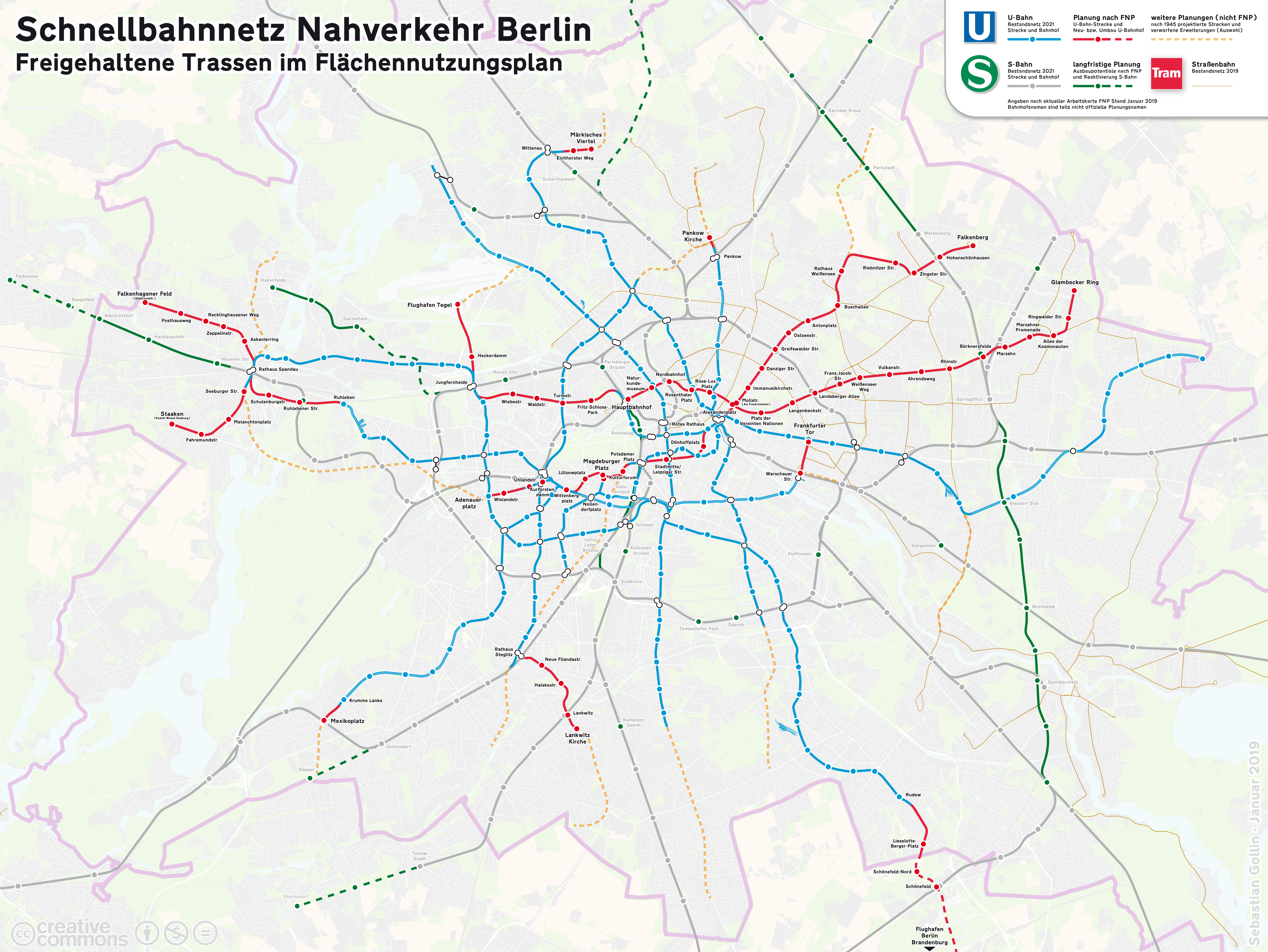
However, this history has not prevented people from literally comparing BVG’s plan to the Nazis. The more prosaic reality is that the 1938 Welthauptstadt Germania U-Bahn expansion plan, other than its ring (built inside of the Ringbahn, the opposite of U0), made it to the 200 km plan and most of the lines it proposed were built, the largest change being that Cold War realities made West Berlin build U7 and U9 to serve the center of West Berlin at the Zoo rather than as additional lines serving Mitte.
The issue of costs
I have not seen an official cost estimate. BUND, which opposes the plan on the grounds that building tramways is better, says that it would cost 35 billion euros. Judging by recent construction costs of realized and proposed lines in Berlin, I think this estimate is broadly correct, if the project is run well.
The estimate is then about 210 million €/km, which looks realistic. The construction of the U5 extension from Alexanderplatz to Brandenburger Tor opened in 2020 at a cost of 280 million €/km in 2022 prices, but that was in the very center of the city, including a station at Museumsinsel mined directly beneath the Spree, for which BVG had to freeze the sandy soil. Conversely, the estimates of outer extensions that were already under planning before a week ago are lower: U7, the most advanced of these, is projected at 890 million € for about 8 km, or 110 million €/km, in an unusually easy (not really urbanized) tunneling environment.
The risk is that such a large project, done all at once, would strain the planning capacity of Berlin and Brandenburg. This exact risk happened in Paris: at 205 million €/km for 80% underground construction Grand Paris Express is more expensive per km than smaller Métro extensions built in the 2010s as it’s so large the region ran out of in-house planning capacity, and its response, setting up a British-style special purpose delivery vehicle (SPDV) along the lines of Crossrail, has resulted in British-style permanent loss of state capacity. Now, even the short Métro extensions, like the planned eastern M1 extension, cost more like GPE and not like similar projects from 10 years ago.
Notably, while France and the Nordic countries are seeing growing construction costs (France from a medium-low level and the Nordic countries from a very low one), Germany is not. I haven’t been able to find historic costs for Berlin with few exceptions. One of those exception, the last section of U9, cost 235 million € in 2022 prices for 1.5 or 1.6 km, or around 150 million €/km; this was built in 1968-74, in a relatively easy area, albeit with extra costs as noted above preparing for the U10 line. Another exception is the final section of U7 to Spandau, which cost around 800 million € for 4.9 km, or around 160 million €/km. Taken together with some numbers I posted here, it’s notable that in the 1970s, the construction costs per km in Italy, Germany, and the UK were all about the same but since then German costs have stayed the same or at worst inched up, Italian costs have fallen due to the anti-corruption laws passed in the wake of mani pulite, and British costs have quadrupled.
The most frustrating part of this discourse is that I’ve yet to see a single German rail advocate express any interest in the issue of costs. The critics of U-Bahn and other rail transport expansion plans who cite costs, of which BUND is a prime example, never talk about how to make metro construction in Germany cheaper; instead, they use it as an argument for why building underground railways is a waste of money, and urban rail must take the form of streetcars, which are held to be not only cheaper but also more moral from a green point of view as they annoy drivers. The same problem crops up in the discourse on high-speed rail, where Germany makes fairly easily fixable mistakes, generally falling under the rubric of over-accommodation of NIMBYs, and thus instead of figuring out how to build more lines, advocates write the idea off as impractical and instead talk about how to run trains on slow lines.
Can Berlin make do with streetcars?
No.
The problem with streetcars is that, no matter how much priority they get over other street traffic, they’re still slow. T3 in Paris, about the most modern urban tramway I’ve seen, running in a grassy reservation in the middle of the 40 meter wide Boulevards des Maréchaux, averages 18 km/h. The Berlin streetcars average 17.6 km/h; they don’t have 100% dedicated lanes at places, but for the most part, they too are run to very high standards, and only minor speedups can be seriously expected. Meanwhile, the U-Bahn averages 30.5 km/h, which is on the high side for the 780 m stop spacing, but is without driverless operations, which raised Paris’s average speed on M1 with its 692 m interstation from 24.4 to 30 km/h, at least in theory. The best Berlin can do with tramway modernization is probably around 20 km/h; the best it can do with the U-Bahn is probably 35 km/h, and with the S-Bahn maybe 45 km/h.
And Berlin is already large enough to need the speed. Leipzig is a good example of an Eastern city maintaining modal split with no U-Bahn, just streetcars and a recently-opened S-Bahn tunnel; in 2018, its modal split for work trips was 47% car, 20% public transport, 22% bike, 11% pedestrian (source, p. 13). But most of the walkable urban area of Leipzig is contained within a four kilometer radius of the main train station, a large majority of the city’s population is within six, and by eight one is already in the suburbs. Slow transportation like bikes and trams can work at that scale, to an extent.
In contrast with Leipzig’s smaller scale, I live four km from Berlin Hauptbahnhof and I’m still in Mitte, albeit at the neighborhood’s southeastern corner where Hbf is at the northwestern one. From the most central point, around Friedrichstrasse, both the Zoo and Warschauer Strasse are four km away, and both have high-rise office buildings. At eight km, one finally gets to Westkreuz and ICC-Messe, Steglitz, Lichtenberg, and the former airport grounds of Tegel; Gropiusstadt, a dense housing project built as transit-oriented development on top of U7, is 13 km from Friedrichstrasse by straight line.
The actual average speed, door-to-door, is always lower than the in-vehicle average speed. There’s access time, which is independent of mode, but then wait times are shorter on a high-intensity metro system than on a more diffuse streetcar network, and extra time resulting from the fact that rail lines don’t travel in a straight line from your home to your destination scales with in-vehicle travel time.
Leipzig’s modal split for work trips is 47% car, 20% public transport. Berlin’s is 28% car, 40% public transport. This is partly because Berlin is bigger, but mostly related to the city’s U-Bahn network; closer to Leipzig’s size class, one finds Prague, with a larger per capita urban rail ridership than Berlin or even Paris, with a system based on metro lines fed by streetcars and high-intensity development near the metro.
Berlin’s multiple centers make this worse. The same tram-not-subway NIMBYs who oppose U-Bahn development believe in building polycentric cities, which they moralize as more human-scale than strong city centers with tall buildings (apparently, Asia is inhuman). The problem is that when designing transportation in a polycentric city, we must always assume the worst-case scenario – that is, that an East Berliner would find work near the Zoo or even at ICC and a Spandauer would find it in Friedrichshain. The Spandauer who can only choose jobs and social destinations within streetcar distance for all intents and purposes doesn’t live in Berlin, lacking access to any citywide amenities or job opportunities; not for nothing, Spandauers don’t vote for NIMBYs, but for pro-development politicians like Raed Saleh.
Truly polycentric cities are not public transport-oriented. Upper Silesia is auto-oriented while Warsaw has one of Europe’s strongest surface rail networks. In Germany, the Rhine-Ruhr is an analog: its major cities have strong internal Stadtbahn networks, but most of the region’s population doesn’t live in Cologne or Essen or Dortmund or Dusseldorf, and the standard way to get between two randomly-selected towns there, as in Silesia, is by car.
The reason BUND and other NIMBYs don’t get this is a historical quirk of Germany. The Stadtbahn – by which I mean the subway-surface mode, not the Berlin S-Bahn line – was developed here in the 1960s and 70s, at a time of rapidly rising motorization. The goal of the systems as built in most West German cities was to decongest city center by putting the streetcars underground; then, the streetcar lines that fed into those systems were upgraded and modernized, while those that didn’t were usually closed. The urban New Left thus associates U-Bahn construction with a conspiracy to get trains out of cars’ way, and Green activists have reacted to the BVG plan by saying trams are the best specifically because they interfere with cars.
That belief is, naturally, hogwash. The subway-surface trolley, for one, was invented in turn-of-the-century Boston and Philadelphia, whose centers were so congested by streetcars, horsecars, and pedestrians that it was useful to bury some of the lines even without any cars. The metro tunnel was invented in mid-Victorian London for the same reason: the route from the train terminals on Euston Road to the City of London was so congested with horsecars there was demand for an underground route. Today, there’s less congestion than there was then, but only because the metro has been invented and the city has spread out, the latter trend raising the importance of high average speed, attainable only with full grade separation.
BUND and others say that the alternative to building 170 km of U-Bahn is building 1,700 km of streetcar. Setting aside that streetcars tend to be built in easier places and I suspect a more correct figure than 1,700 is 1,000 km, Berlin can’t really use 1,700 or 1,000 or even 500 km of tramway, because that would be too slow. Saturating every major street within the Ring with surface rail tracks would run into diminishing returns fast; the ridership isn’t there, getting it there requires high-density development that even SPD would find distasteful and not just the Greens, and streetcars with so many intersections with other streetcars would have low average speed. I can see 100-200 km of streetcar, organized in the Parisian fashion of orbital lines feeding the U- and S-Bahn; M13 on Seestrasse is a good example. But the core expansion must be U- and S-Bahn.
Okay, but is the BVG plan good?
Overall, it’s important for Berlin to expand its U- and S-Bahn networks, both by densifying them with new trunk lines and by expanding them outward. However, some of the lines on the BVG map are so out there that the plan is partly just crayon with an official imprint.
Core lines
The way I see it, the proposal includes 2.5 new trunk lines: U3 (again, formerly planned as U10), U4, and the western extension of U5.
Of those, U3 and U5 are unambiguously good. Not for nothing, they’ve been on the drawing board for generations, and many of their difficult crossings have already been built. Jungfernheide, where U5 would connect with U7, was built with such a connection in mind; the plan was and to an extent remains to extend U5 even further, sending it north to what used to be Tegel Airport and is now a planned redevelopment zone as the Urban Tech Republic, but the new BVG proposal gives away the Tegel connection to the U0 ring.
The U3 and U4 trunks in fact are planned along the routes of the two busiest tramways in the city, the M4 and combined M5/M6/M8 respectively (source, p. 7). The U3 plan thus satisfies all criteria of good subway construction – namely, it’s a direct radial line, in fact more direct than U2 (built around and not on Leipziger Strasse because the private streetcar operator objected to public U-Bahn development on its route), replacing a busy surface route. The U4 expansion mostly follows the same criterion; I am less certain about it because where M5 and M6 today serve Alexanderplatz, the proposed route goes along that of M8, which passes through the northern margin of city center, with some employment but also extensive near-center residential development near the Mitte/Gesundbrunnen boundary. I’m still positive on the idea, but I would rate it below the U3 and U5 extensions, and am also uncertain (though not negative) on the idea of connecting it from Hbf south to U4.
The U5 extension parallels no streetcar, but there’s high bus ridership along the route. The all-left coalition was planning to build a streetcar instead of an U-Bahn on this route. If it were just about connecting Jungfernheide to Hbf I’d be more understanding, but if the Urban Tech Republic project is built, then that corner of the region will need fast transportation in multiple directions, on the planning principle outlined above that in a polycentric city the public transport network must assume the worst-case scenario for where people live and work.
Outward extensions
All of Berlin’s nine U-Bahn lines are planned with at least one outward extension. These are a combination of very strong, understandable, questionable, and completely drunk.
The strongest of them all is, naturally, the U8 extension to Märkisches Viertel. In 2021, it was rated the lowest-cost-per-rider among the potential extensions in the city, at 13,160€/weekday trip; the U7 extension to the airport is projected to get 40,000 riders, making it around 22,000€/trip. It has long been to the city’s shame that it has not already completed this extension: Märkisches Viertel is dense, rather like Gropiusstadt on the opposite side of the city except with slightly less nice architecture, and needs a direct U-Bahn connection to the center.
Several other extensions are strong as well – generally ones that have been seriously planned recently. Those include U7 to the airport, the combination of the one-stop expansion of U2 to Pankow Kirche and the northeastern extension of U9 to intersect it and then terminate at the S-Bahn connection at Pankow-Heinersdorf, and U7 to the southwest to not just the depicted connection to U1 at Gatower Strasse but also along the route that the new plan gives to U1 to Heerstrasse.
The U3 expansion to the southwest is intriguing in a different way. It’s a low-cost, low-benefit extension, designed for network completeness: a one-stop extension to the S-Bahn at Mexikoplatz is being planned already, and the BVG plan acknowledges near-future S-Bahn plans adding a new southwestern branch and connect to it at Düppel.
Unfortunately, most of the other radial extensions go in the opposite direction from U3: where U3 acknowledges S-Bahn expansion and aims to connect with it, these other plans are closely parallel to S-Bahn lines that are not at capacity and are about to get even more capacity soon. Spandau, in particular, sees a train every 10 minutes; the Stadtbahn’s core segment has three trains in 10 minutes, with more demand from the east than from the west, so that a train every 10 minutes goes to Spandau, another goes to Potsdam, and a third just turns at Westkreuz since demand from the west is that weak. Creating more demand at Spandau would rebalance this system, whereas building additional U-Bahn service competing with current S-Bahn service (especially the U1 plan, which loses benefit west of the Ring) or with future expansion (such as U2 – compare with the expansion on the 2019 plan) would just waste money.
The southern extensions are a particularly bad case of not working with the S-Bahn but against it. The North-South Tunnel has 18 peak trains per hour, like the Stadtbahn; this compares with 30 on the trunk of the Munich S-Bahn. The ongoing S21 project should divert southeast, but as currently planned, it’s essentially a second North-South Tunnel, just via Hbf and not Friedrichstrasse, hence plans to beef up service to every five minutes to Wannsee and add branches, such as to Düppel. This massive increase in S-Bahn capacity is best served with more connections to the S-Bahn south of the Ring, such as east-west streetcars feeding the train; north-south U-Bahn lines, running more slowly than the S-Bahn, are of limited utility.
Finally, the extension of U1 to the northeast is a solution looking for a problem. U1’s terminus is frustratingly one S-Bahn stop away from the Ring, and perhaps the line could be extended east. But it points north, and is elevated, and past the U5 connection at Frankfurter Tor there’s no real need to serve the areas with another line to Friedrichshain.
The ring
The radial component of the BVG plan includes good and bad ideas. In contrast, the U0 ring is just a bad idea all around. The problem is that it doesn’t really hit any interesting node, except Tegel and Westkreuz, and maybe Steglitz and Pankow; Alt-Mariendorf, for example, is not especially developed. Berlin is polycentric within the Ring, but the importance of destinations outside it is usually low. This should be compared with Grand Paris Express’s M15 ring, passing through La Défense and the Stade de France.
Where circumferential service is more useful is as a feeder to S- and U-Bahn lines connecting people with the center. However, metro lines don’t make good feeders for other metro lines; this is a place where streetcars are genuinely better. The required capacity is low, since the constraints are on the radial connection to the center. The expected trip length is short and a transfer is required either way, which reduces the importance of speed – and at any rate, these outer circumferential routes are likely less congested, which further reduces the speed difference. The differences in cost permit streetcars to hit multiple stations on each line to connect with (though this means two parallel lines, not ten); this is not the same as fantasies about 1,700 km of streetcar in areas where people vote Green.
Is this a good plan?
Well, it’s about half good. Of the 163 km in BVG’s proposal, I think around 68 are good, and the rest, split between the U0 ring and the less useful outer extensions, should be shelved. That’s the crayon element – parts of the plan feel like just drawing extra extensions, by which I mean not just U0 but also the southern extensions.
However, substantial expansion of the U-Bahn is obligatory for Berlin to maintain healthy growth without being choked by cars. NIMBY fantasies about deurbanizing workplace geography would make the city more like Los Angeles than like their ideal of a 15-minute bikable small city center. Berlin needs to reject this; small is not beautiful or sustainable, and the city’s transport network needs to grow bigger and better with a lot more subway construction than is currently planned.
What’s more, the fact that construction costs in Germany are fundamentally the same in real terms as they were 40-50 years ago means that the country should accelerate its infrastructure construction program. Benefits for the most part scale with national GDP per capita – for example, the value of time for commuters, students, and other travelers so scale. Ignoring climate entirely, lines that were marginal in 1980 should be strong today; not ignoring climate, they are must-builds, as is high-density housing to fill all those trains and enable people to live in a desirable city with low car usage.
Quick Note: Catalunya Station
Barcelona’s commuter rail network has a few distinct components. In addition to the main through-running sections, there are some captive lines terminating at one of two stations, Espanya and Catalunya. Catalunya is especially notable for its very high throughput: the system feeding it, the Barcelona-Vallès Line, has two running tracks, fanning out onto five station tracks, of which only three are used in regular service. Despite the austere infrastructure, the station turns 32 trains per hour on these tracks. I believe this is the highest turnback rate on a commuter rail network. The Chuo Line in Tokyo turns 28 trains per hour on two rather than three tracks but it’s with the same two running tracks as the Catalunya system, and with considerably less branching.
I bring this up because I was under the impression Catalunya turned 24 rather than 32 trains per hour when writing about how Euston could make do with fewer tracks than planned for High Speed 2. But several people since have corrected me, including Shaul Picker (who looked at the timetables) and planning engineer Joan Bergas Massó (who, I believe, wrote them).
The current situation is that the Vallès Line includes both proper commuter lines and metro, sharing tracks. The commuter part of the system comprises two branches, Terrassa carrying S1 and short-turning trains on S7 and Sabadell carrying S2 and short-turning trains on S6; some trains skip stops, but it’s not a consistent pattern in which S1 and S2 run express and S6 and S7 run local. A branch entirely within the city is signed as a metro line, designated L7. Currently, all L7 trains use track 4, turning 8 trains per hour, while the other lines use tracks 1 and 2, turning 24 trains per hour in total.
I stress that while this is a commuter line – it goes into suburbia and descends from a historic steam train rather than a greenfield metro – it is not connected with the mainline network. So it’s easier to turn trains there than on an intricately branched system; the Chuo Line is not as hermetically sealed but is similar in having little other traffic on it than the rapid trains from Tokyo to its in-prefecture western suburbs. Nonetheless, there are multiple branches and stopping patterns; this is not a metro system where all trains are indistinguishable and passengers only care about the interval between trains rather than about the overall schedule.
Who Through-Running is For
Shaul Picker is working on an FAQ for the benefit of people in the New York area about the concept of commuter rail through-running and what it’s good for. So in addition to contributing on some specific points, I’d like to step back for a moment and go over who the expected users are. This post needs to be thought of as a followup from what I wrote a month ago in which I listed the various travel markets used by modern commuter rail in general, making the point that this is a predominantly urban and inner-suburban mode, in which suburban rush hour commuters to city center are an important but secondary group, even where politically commuter rail is conceived of as For the Suburbs in opposition to the city, as in Munich. My post was about all-day frequency, but the same point can be made about the physical infrastructure for through-running, with some modifications.
The overall travel markets for regional rail
The assumption throughout is that the city region has with a strong center. This can come from a few square kilometers of city center skyscrapers, as is the norm in the United States (for example, in New York, Chicago, or Boston, but not weaker-centered Los Angeles), or from a somewhat wider region with office mid-rises, as is the norm in European cities like Paris, Stockholm, Munich, Zurich, and Berlin. Berlin is polycentric in the sense of having different job centers, including Mitte, City-West at the Zoo, and increasingly Friedrichshain at Warschauer Strasse, but these are all within the Ring, and overall this inner zone dominates citywide destinations. In cities like this, the main travel markets for commuter rail are, in roughly descending order of importance,
- Urban commuter trips to city center
- Commuter trips to a near-center destination, which may not be right at the one train station of traditional operations
- Urban non-work trips, of the same kind as subway ridership
- Middle-class suburban commutes to city center at traditional mid-20th century work hours, the only market the American commuter rail model serves today
- Working-class reverse-commutes, not to any visible office site (which would tilt middle-class) but to diffuse retail, care, and service work
- Suburban work and non-work trips to city center that are not at traditional mid-20th century hours
- Middle-class reverse-commutes and cross-city commutes
I center urban commuter trips because even in places with extensive suburbanization, commutes are more urban than suburban. Long Island, an unusually job-poor, commuter-oriented suburb, has 2.9 million people as of the 2020 census and, per OnTheMap, 191,202 Manhattan-bound commuters and 193,536 outer borough-bound commuters. Queens has 2.4 million people, 871,253 in-city commuters, 384,223 Manhattan-bound commuters, and 178,062 commuters to boroughs other than itself and Manhattan. The Metro-North suburbs – Westchester, Putnam, Dutchess, and Fairfield Counties (New Haven omitted as it’s not really a suburb) – have 2.35 million people and 143,862 Manhattan-bound commuters and 79,821 outer borough-bound commuters. To work regionwide, commuter rail needs to be usable by the largest commute market; it’s urban rail that’s capable of also serving the suburbs without building suburban metro tunnels, rather than predominantly suburban rail.
Through-running
Through-running means that trains run from one side of the region to the other through city center, rather than terminating at a traditional city terminal. Rarely, this means running trains through a city center station that already has through-tracks, like Penn Station or Stockholm Central; usually, this requires building new tunnels to connect different terminals, as it would to get to Grand Central and as it did in the other European comparison cases.
This rearranges the travel markets for commuter rail, but only somewhat. The largest group, urban commuters to city center, shrinks somewhat: terminating trains to some extent already serve it. The qualifiers come from the fact that city center is rarely entirely within walking distance of the terminal; it is in Stockholm, but it’s small and I suspect the reason Stockholm’s monocentric CBD is walking distance from the intercity station is that it opened as a through-station in 1871 already. In Boston, most of the CBD is close to South Station, but much of it isn’t, and little is within walking distance of North Station. In New York, the CBD is large enough that service to multiple destinations is desirable when feasible, for example both East Side and West Side destinations in Midtown and even Lower Manhattan, requiring additional through-running commuter rail tunnels.
What really shines with through-running is urban trips that are not commutes, or are commutes to a near-center destination on the wrong side of the CBD (for example, south of it for commuters from Uptown Manhattan or the Bronx). New York is unusually asymmetric in that there’s much more city east of Manhattan than west of it, where there’s just the urban parts of Hudson County and Newark. But even there, New Jersey-Brooklyn and New Jersey-Queens commutes matter, as do Bronx-Brooklyn commutes.

Even then, the urban commutes are significant: there are 55,000 commuters from the Bronx to Manhattan south of 23rd Street. These in-city travel markets are viable by subway today, but are for the most part slow even on the express trains – the A train’s run from Inwood to Jay Street and the 4’s run from Woodlawn to Brooklyn Bridge are both scheduled to take 45 minutes for 22.5 km, an average speed of 30 km/h. And then the New Jersey-to-outer borough commutes are largely unviable by public transportation – they cost double because there’s no fare integration between PATH and the subway and the transfers are onerous and slow, and besides, PATH’s coverage of the urban parts of North Jersey leaves a lot to be desired.
Adapting the city
Berlin is in a way the most S-Bahn-oriented city I know of. It’s polycentric but all centers are within the Ring and close to either the Stadtbahn or (for Potsdamer Platz) the North-South Tunnel. This shouldn’t be surprising – the Stadtbahn has been running since the 1880s, giving the city time to adapt to it, through multiple regime changes, division, and reunification. Even Paris doesn’t quite compare – the RER’s center, Les Halles, is a retail but not job center, and the five-line system only has two CBD stops, the RER A’s Auber and the RER E’s Haussmann-Saint-Lazare.
Can New York become more like Berlin if it builds through-running? The answer is yes. Midtown would remain dominant, and overall the region would become less rather than more polycentric as better commuter rail service encouraged job growth in the Manhattan core. But it’s likely any of the following changes would grow the market for commuter rail to take advantage of through-running over time:
- Job growth in Lower Manhattan, which has struggled with office vacancy for decades
- Job growth in non-CBD parts of Manhattan that would become accessible, like Union Square, or even Midtown South around Penn Station, which is lower-rise than the 40s and 50s
- Job growth in near-center job centers – Downtown Brooklyn may see a revival, and Long Island City is likely to see a larger upswing than it is already seeing if it becomes more accessible from New Jersey and not just the city
- Residential location adjustment – Brooklyn workers may choose to depend on the system and live in the Bronx or parts of New Jersey with good service instead of moving farther out within Brooklyn or suburbanizing and driving to work
- Residential transit-oriented development near outlying stations, in urban as well as suburban areas
Philadelphia and High-Speed Rail Bypasses (Hoisted from Social Media)
I’d like to discuss a bypass of Philadelphia, as a followup from my previous post, about high-speed rail and passenger traffic density. To be clear, this is not a bypass on Northeast Corridor trains: every train between New York and Washington must continue to stop in Philadelphia at 30th Street Station or, if an in my opinion unadvised Center City tunnel is built, within the tunnel in Center City. Rather, this is about trains between New York and points west of Philadelphia, including Harrisburg, Pittsburgh, and the entire Midwest. Whether the bypass makes sense depends on traffic, and so it’s an example of a good investment for later, but only after more of the network is built. This has analogs in Germany as well, with a number of important cities whose train stations are terminals (Frankfurt, Leipzig) or de facto terminals (Cologne, where nearly all traffic goes east, not west).
Philadelphia and Zoo Junction
Philadelphia historically has three mainlines on the Pennsylvania Railroad, going to north to New York, south to Washington, and west to Harrisburg and Pittsburgh. The first two together form the southern half of the Northeast Corridor; the third is locally called the Main Line, as it was the PRR’s first line.

Trains can run through from New York to Washington or from Harrisburg to Washington. The triangle junction northwest of the station, Zoo Junction, permits trains from New York to run through to Harrisburg and points west, but they then have to skip Philadelphia. Historically, the fastest PRR trains did this, serving the city at North Philadelphia with a connection to the subway, but this was in the context of overnight trains of many classes. Today’s Keystone trains between New York and Harrisburg do no such thing: they go from New York to Philadelphia, reverse direction, and then go onward to Harrisburg. This is a good practice in the current situation – the Keystones run less than hourly, and skipping Philadelphia would split frequencies between New York and Philadelphia to the point of making the service much less useful.
When should trains skip Philadelphia?
The advantage of skipping Philadelphia are that trains from New York to Harrisburg (and points west) do not have to reverse direction and are therefore faster. On the margin, it’s also beneficial for passengers to face forward the entire trip (as is typical on American and Japanese intercity trains, but not European ones). The disadvantage is that it means trains from Harrisburg can serve New York or Philadelphia but not both, cutting frequency to each East Coast destination. The effect on reliability and capacity is unclear – at very high throughput, having more complex track sharing arrangements reduces reliability, but then having more express trains that do not make the same stop on the same line past New York and Newark does allow trains to be scheduled closer to each other.
The relative sizes of New York, Philadelphia, and Washington are such that traffic from Harrisburg is split fairly evenly between New York on the other hand and Philadelphia and Washington on the other hand. So this really means halving frequency to each of New York and Philadelphia; Washington gets more service with split service, since if trains keep reversing direction, there shouldn’t be direct Washington-Harrisburg trains and instead passengers should transfer at 30th Street.
The impact of frequency is really about the headway relative to the trip time. Half-hourly frequencies are unconscionable for urban rail and very convenient for long-distance intercity rail. The headway should be much less than the one-way trip time, ideally less than half the time: for reference, the average unlinked New York City Subway trip was 13 minutes in 2019, and those 10- and 12-minute off-peak frequencies were a chore – six-minute frequencies are better for this.
The current trip time is around 1:20 New York-Philadelphia and 1:50 Philadelphia-Harrisburg, and there are 14 roundtrips to Harrisburg a day, for slightly worse than hourly service. It takes 10 minutes to reverse direction at 30th Street, plus around five minutes of low-speed running in the station throat. Cutting frequency in half to a train every two hours would effectively add an hour to what is a less than a two-hour trip to Philadelphia, even net of the shorter trip time, making it less viable. It would eat into ridership to New York as well as the headway rose well above half the end-to-end trip, and much more than that for intermediate trips to points such as Trenton and Newark. Thus, the current practice of reversing direction is good and should continue, as is common at German terminals.
What about high-speed rail?
The presence of a high-speed rail network has two opposed effects on the question of Philadelphia. On the one hand, shorter end-to-end trip times make high frequencies even more important, making the case for skipping Philadelphia even weaker. In practice, high speeds also entail speeding up trains through station throats and improving operations to the point that trains can change directions much faster (in Germany it’s about four minutes), which weakens the case for skipping Philadelphia as well if the impact is reduced from 15 minutes to perhaps seven. On the other hand, heavier traffic means that the base frequency becomes much higher, so that cutting it in half is less onerous and the case for skipping Philadelphia strengthens. Already, a handful of express trains in Germany skip Leipzig on their way between Berlin and Munich, and as intercity traffic grows, it is expected that more trains will so split, with an hourly train skipping Leipzig and another serving it.
With high-speed rail, New York-Philadelphia trip times fall to about 45 minutes in the example route I drew for a post from 2020. I have not done such detailed work outside the Northeast Corridor, and am going to assume a uniform average speed of 240 km/h in the Northeast (which is common in France and Spain) and 270 km/h in the flatter Midwest (which is about the fastest in Europe and is common in China). This means trip times out of New York, including the reversal at 30th Street, are approximately as follows:
Philadelphia: 0:45
Harrisburg: 1:30
Pittsburgh: 2:40
Cleveland: 3:15
Toledo: 3:55
Detroit: 4:20
Chicago: 5:20
Out of both New York and Philadelphia, my gravity model predicts that the strongest connection among these cities is by Pittsburgh, then Cleveland, then Chicago, then Detroit, then Harrisburg. So it’s best to balance the frequency around the trip time to Pittsburgh or perhaps Cleveland. In this case, even hourly trains are not too bad, and half-hourly trains are practically show-up-and-go frequency. The model also predicts that if trains only run on the Northeast Corridor and as far as Pittsburgh then traffic fills about two hourly trains; in that case, without the weight of longer trips, the frequency impact of skipping Philadelphia and having one hourly train run to New York and Boston and another to Philadelphia and Washington is likely higher than the benefit of reducing trip times on New York-Harrisburg by about seven minutes.
In contrast, the more of the network is built out, the higher the base frequency is. With the Northeast Corridor, the spine going beyond Pittsburgh to Detroit and Chicago, a line through Upstate New York (carrying Boston-Cleveland traffic), and perhaps a line through the South from Washington to the Piedmont and beyond, traffic rises to fill about six trains per hour per the model. Skipping Philadelphia on New York-Pittsburgh trains cuts frequency from every 10 minutes to every 20 minutes, which is largely imperceptible, and adds direct service from Pittsburgh and the Midwest to Washington.
Building a longer bypass
So far, we’ve discussed using Zoo Junction. But if there’s sufficient traffic that skipping Philadelphia shouldn’t be an onerous imposition, it’s possible to speed up New York-Harrisburg trains further. There’s a freight bypass from Trenton to Paoli, roughly following I-276; a bypass using partly that right-of-way and, where it curves, that of the freeway, would require about 70 km of high-speed rail construction, for maybe $2 billion. This would cut about 15 km from the trip via 30th Street or 10 km via the Zoo Junction bypass, but the tracks in the city are slow even with extensive work. I believe this should cut another seven or eight minutes from the trip time, for a total of 15 minutes relative to stopping in Philadelphia.
I’m not going to model the benefits of this bypass. The model can spit out an answer, which is around $120 million a year in additional revenue from faster trips relative to not skipping Philadelphia, without netting out the impact of frequency, or around $60 million relative to skipping via Zoo, for a 3% financial ROI; the ROI grows if one includes more lines in the network, but by very little (the Cleveland-Cincinnati corridor adds maybe 0.5% ROI). But this figure has a large error bar and I’m not comfortable using a gravity model for second-order decisions like this.
One- and Two-Seat Rides
All large urban rail networks rely on transfers – there are too many lines for direct service between any pair of stations. However, transfers are still usually undesirable; there is a transfer penalty, which can be mitigated but not eliminated. This forces the planners who design urban and suburban rail systems to optimize: too many transfers and the trips are too inconvenient, too few and the compromises required to avoid transfers are also too inconvenient. How do they do it? And why?
Of note, the strategies detailed below are valid for both urban rail and suburban commuter rail systems. Multi-line commuter rail networks like the RER and the Berlin S-Bahn tend to resemble urban rail in their core and work in conjunction with the rest of the urban rail network, and therefore strategies for reducing the onerousness of transferring work in much the same way for both kinds of systems. Suburban strategies such as timing half-hourly trains to meet connecting buses are distinct and outside the scope of this post.
Transfer penalties
Passengers universally prefer to avoid transfers between vehicles, keeping everything else constant. The transportation studies literature has enough studies on this pattern that it has a name: transfer penalty. The transfer penalty consists of three elements:
- Walking time between platforms or bus curbs
- Waiting time for the connecting train or bus
- An independent inconvenience factor in addition to the extra time
One meta-study of this topic is by Iseki-Taylor-Miller of the Institute for Transportation Studies. There’s a bewildering array of different assumptions and even in the same city the estimates may differ. The usual way this is planned in elasticity estimates is to bundle the inconvenience factor into walking and waiting times; passengers perceive these to be more onerous than in-vehicle time, by a factor that depends on the study. Iseki-Taylor-Miller quote a factor as low as 1.4-1.7 and Lago-Mayworm-McEnroe’s classic paper, sourced to a Swedish study, go up to 3; Teulings-Ossokina-de Groot suggest it is 2, which is the figure I usually use, because of the convenience of assuming worst-case scenario for waiting time (on average, the wait is half the headway).
The penalty differs based on the quality of station facilities, and Fan-Guthrie-Levinson investigate this for bus shelter. However, urban rail estimates including those in the above meta-studies are less dependent on station facilities, which are good in all cases.
Mitigating the transfer penalty
Reducing the transfer penalty for riders can be done in three ways, if one believes the model with a constant penalty factor (say 2):
- Reducing the number of transfers
- Reducing walking time between platforms
- Reducing waiting time for trains
All three are useful strategies for good urban rail network planning, and yet all three are useful only up to a point, beyond which they create more problems than they solve.
Reducing transfers
The most coherent network planning principle for reducing passengers’ need to transfer is to build radial rail networks. Such networks ideally ensure each pair of lines intersects once in or near city center, with a transfer, and thus there is at most one transfer between any pair of stations. A circumferential line may be added, creating some situations in which a three-legged trip is superior in case it saves a lot of time compared with the two-legged option; in Moscow, the explicit purpose of the Circle Line is to take pressure off the congested passageway of the central transfer connecting the first three lines.
In general, the most coherent radial networks are those inherited from the Soviet tradition of metro building; the London Underground, which influenced this tradition in the 1920s, is fairly radial itself, but has some seams. It’s important in all cases to plan forward and ensure that every pair of lines that meets has a transfer. New York has tens of missed connections on the subway, and Tokyo has many as well, some due to haphazard planning, some due to an explicit desire to build the newer lines as express relief lines to the oversubscribed older lines.
On a regional rail network, the planning is more constrained by the need to build short tunnels connecting existing lines. In that case, it’s best to produce something as close to a coherent radial network with transfers at all junctions as possible. Through-running is valuable here, even if most pairs of origins and destinations on a branched commuter line trunk still require a transfer, for two reasons. First, if there is through-running, then passengers can transfer at multiple points along the line, and not just at the congested city center terminus. And second, while through-running doesn’t always cut the transfer for suburb-to-suburb trips, it does reliably cut the transfer for neighborhood-to-suburb trips involving a connection to the metro: a diameter can be guaranteed to connect with all radial metro lines, whereas a radius (terminating at city center) will necessarily miss some of them, forcing an extra transfer on many riders.
Reducing walking time
The ideal transfer is cross-platform, without any walking time save that necessary to cross a platform no more than 10-15 meters wide. Some metro building traditions aim for this from the outset: London has spent considerable effort on ensuring the key Victoria line transfers are cross-platform and this has influenced Singapore and Hong Kong, and Berlin has accreted several such transfers, including between the U- and S-Bahn at Wuhletal.
However, this is not always viable. The place where transfers are most valuable – city center – is also where construction is the most constrained. If two lines running under wide streets cross, it’s usually too costly to tilt them in such a way that the platforms are parallel and a cross-platform transfer is possible. But even in that case, it’s best to make the passageways between the platforms as short as possible. A cruciform configuration with stairs and an elevator in the middle is the optimum; the labyrinthine passageways of Parisian Métro stations are to be avoided.
Reducing waiting time
The simplest way to reduce waiting time is to run frequently. Passengers’ willingness to make untimed transfers is the highest when frequency is the highest, because the 2-minute wait found on such systems barely lengthens one’s trip even in the worst case, when one has frustratingly just missed the train.
Radial metro networks based on two- rather than one-seat rides pair well with high frequency. Blog supporter and frequent commenter Threestationsquare went viral last month when he visited Kyiv, a Soviet-style three-line radial system, and noted that due to wartime cuts the trains only run every 6-7 minutes off-peak; Americans amplified this and laughed at the idea that base frequency could be so high that a train every 7 minutes takes the appellation “only.”
When frequency is lower, for example on a branch or at night, cross-platform transfers can be timed, as is the case in Berlin. But these are usually accidental transfers, since the core city center transfers are on frequent trunks, and thus the system is only valuable at night. Moreover, timed transfers almost never work outside cross-platform transfers, which as noted above are not always possible; the only example I’m aware of is in Vienna, where a four-way transfer with stacked parallel platforms is timed.
This is naturally harder on a branched commuter rail system. In that case, it’s possible to set up the timetable to make the likeliest origin-destination pairs have short transfer windows, or even one-seat rides. However, in general transfers may require a wait as long as the system’s base clockface intervals, which is unlikely to be better than 20 minutes except on the busiest trunks in the largest cities; even Paris mixes 10-, 15-, and occasionally 20- and 30-minute intervals on RER branches.
More on Six-Minute Service in New York
Two years ago I wrote about how New York should aim to run every bus and subway service every six minutes off-peak. Buses would require a combination of aggressive bus redesign and speedup treatments for this to be viable. The subway already has very low variable operating costs off-peak and such a boost in frequency would naturally increase efficiency; New York City Transit gets around 550 service-hours annually per train driver, whereas the Berlin U-Bahn with its flat all-day schedule gets around 900. But now, the more mainstream New York-area transit advocacy group Riders’ Alliance has its own proposal for six-minute service, which it has aggressive marketed using the hashtag #6minuteservice.
This is a good campaign and I hope more people in the region take notice and push for it until the state implements it in full. The impact on passenger convenience is massive, not just in the form of shorter waits but also higher reliability coming from better timetabling, and hopefully also slightly more speed coming from said higher reliability. The proposal says that it would take $250 million a year in extra spending to effect this system, and it’s unknown but plausible that it would increase ridership by enough to defray this cost entirely, even without any efficiency treatments to reduce unit costs.
What’s in the Riders’ Alliance proposal?
Between 5 am and 9 pm on weekdays, and between 8 am and 10 pm on weekends, all subway routes and the top 100 bus routes in the city should run at worst every six minutes. This echoes a report by the comptroller’s office from last year, recommending this as an alternative to rush hour-focused service by bringing up corona-related ridership decreases.
It’s not stated but I think the subway routes in question are reckoned by letter or number, which means the A train runs every six minutes but each of its two branches runs every 12. This is fine – the two branches of the A are exceptionally far out, which is why a single service splits to them, where elsewhere in New York each branch gets its own number or letter.
The implications for timetabling
Timetabling a consistent all-day service is much easier than timetabling bespoke service patterns. The Riders’ Alliance proposal aims to face the general public rather than planners and therefore omits this benefit, but this benefit reaches passengers as well, in non-obvious ways.
First, if all trains and buses run every six minutes, then it’s possible to set up clockface timetables. These don’t matter very much if they run every six minutes, but they do if they run every 12, as I expect the two A branches to. The same is true of buses that branch: some outer ends may run every 12 minutes, in which case they can and should run on repeating clockface timetables that passengers can memorize. Passengers who can remember “my bus leaves at :01, :13, :25, :37, and :49” without having to consult timetables or trip planners all the time are likelier to take the trip; this was my commute for a year in Vancouver.
The A train today runs every 15 minutes on each branch but it’s not on a consistent clockface schedule, which depresses ridership. In effect, current practice is little different from what Swiss planners warn of: they say the best way to reduce ridership is to run service every 11, 13, or 17 minutes, rather than every 12 or 15 on a clockface pattern.
Second, if all trains run on the same frequency, then service planning on a complexly interlined system like New York’s becomes more tractable. Today, every train runs on a separate frequency, often different from the services it shares track with. The 2 and 3 trains share track most of the way, from Franklin Avenue to 135th Street, but the 2 is just a little more frequent, resulting in the following northbound timetable at Franklin:
10:03: 2
10:07: 3
10:12: 2
10:15: 3
10:21: 2
10:28: 3
10:32: 2
10:34: 3
10:37: 2
10:41: 3
10:43: 2
10:49: 2
10:51: 3
10:57: 3
11:01: 2
11:03: 3
11:09: 2
11:15: 3
11:17: 2
11:22: 3
11:24: 2
11:28: 3
This is irregular both on the trunk and on each individual service – the 2 on average runs every eight minutes but has a 12-minute gap, and the 3 runs on average every nine but also has a 12-minute gap. It’s an unavoidable consequence of the combination of extensive reverse-branching and subway frequency guidelines that run different services at different headways. The six-minute service proposal straightens this by aligning the trains to a single frequency, with regular alternation between successive trains on trunks.
And third, another benefit of a regular frequency to planning is that schedule planners can reliably avoid merge conflicts. This, in turn, speeds up service, which is full of planned delays and schedule padding at pain points. It’s not a full substitute for deinterlining, which would eliminate the merge conflicts at the worst junctions, but it makes it viable to no longer write impossible schedules with the planning department that New York City Transit has.
Service quality and demographics
Both Riders’ Alliance and the comptroller report it uses as its source point out demographic differences between peak and off-peak riders: rush hour subway commuters have a median income of $50,783 a year, even higher (slightly) than drivers, but off-peak subway commuters have a median income of $37,048 and bus commuters have a median income of $30,374.
In both reports this is taken to be indicative that off-peak service is mostly for poorer people, but it’s not the right analysis. The picture that emerges from the data is not that in general rush hour commuters outearn off-peak commuters; for one, most off-peak commutes are done by car, not by public transportation. Rather, what’s going on is that off-peak public transit quality is bad and this suppresses ridership among those who can afford a car.
By the same token, we can look at the incomes of commuters in regions of the United States that have no public transit to speak of – maybe some buses or even a few trains but with rounding-error ridership and low single-digit modal split. In metro New York, public transit and car commuters have about the same median income, and in some secondary transit cities like Chicago public transit commuters actually outearn drivers, since service to non-CBD destinations is so bad it suppresses ridership below median income more than above it. But in places like Los Angeles, the median income of transit commuters is not much more than half that of car commuters, because service quality is so bad that anyone who can afford to drive does.
The upshot of this is that better off-peak transit service is going to increase the average income of off-peak transit users, by attracting people who currently drive. This is also going to lead to higher-socioeconomic status shifts: higher levels of degree attainment, a larger proportion of white riders, a larger proportion of native-born riders.
I bring this up because a rise in the relative average income of users as service quality improves means the improvement is working as intended. It doesn’t mean the subway is gentrifying or turns away poorer riders, it just means it no longer repels riders who can afford to drive. This is important, because too much American transit planning is based on market segmentation in which service is supposed to be for a specific class of rider, and if the demographics are changing it means it’s being revamped for a different class. In reality, there’s just one transit system for one city and income differences are indicative of quality differences and not of inherent differences in the travel market.
How much does this cost? What is the ridership impact?
The Riders’ Alliance proposal says the additional cost of the program is $250 million a year in operating expenses. In 2019, NYCT spent $8.8 billion on operations and got $4.6 billion in fares, so this is in theory a 6% increase in subsidy, and in practice a little less as better service attracts more fare-paying riders. This is without any concurrent attempts to use the increase in service to increase efficiency (read: reduce unit staffing levels) and, I think, without bus speedups that permit much higher frequency for the same cost.
It’s unclear what the revenue impact should be; the ridership impact can be estimated from longstanding results in the literature about ridership-frequency elasticity, which in the case of NYCT should be about 0.4. The proposal increases off-peak service on the subway by around 50% in principle and a bit more in practice because of the reduced variability in frequency, say two-thirds: most lines are to go from 10- to six-minute headways and the rest, which are mostly more frequent than this, get a smaller increase that we round up to two-thirds by taking the impact of higher reliability into account. This means an increase in off-peak ridership of around 23%. The bus impact is even larger – in Brooklyn the median bus headway is right between 12 and 15 minutes, and even taking into account that the busiest buses do much better, this is close to a doubling of the effective frequency.
In turn, most ridership is off-peak. In 2019, peak (7-10 am) ridership into the Manhattan core was 923,000 per weekday, amounting to 44% of ridership entering the Manhattan core on a weekday, or around 33% of all inbound weekday ridership and 27% of all ridership. Even adding a bit to account for peak ridership that doesn’t enter Manhattan, only about a third of subway ridership in New York was at the peak before corona; the peak share has fallen since, but is slowly creeping back up as workers slowly return to the office. Raising two-thirds of ridership by 23% is massive – it’s a 15% systemwide increase for a much smaller increase in operating costs, and a somewhat larger increase in bus ridership to boot.
Unfortunately, I can’t turn this into a revenue impact estimate. While the demographics in the section above specify off-peak commuters, the studies that my ridership estimate is based on measure riders, including peak commuters who ride more often for non-work trips. Such riders already have monthly passes, so making it easier for them to ride is excellent for the city’s long-term health but doesn’t defray the added cost. Converted riders who are not already on the system as well as the odd peak rider who doesn’t already have a pass do generate more revenue, but I don’t know how many there are; these need to be a little more than a third of the overall increase in ridership to fully defray costs, which sounds plausible to me.
Eno’s Project Delivery Webinar
Eno has a new report out about mass transit project delivery, which I encourage everyone to read. It compares the American situation with 10 other countries: Canada, Mexico, Chile, Norway, Germany, Italy, South Africa, Japan, South Korea, and Australia. Project head Paul Lewis just gave a webinar about this, alongside Phil Plotch. Eno looks at high-level governance issues, trying to figure out if there’s some correlation with factors like federalism, the electoral system, and the legal system; there aren’t any. Instead of those, they try teasing out project delivery questions like the role of consultants, the contracting structure, and the concept of learning from other people.
This is an insightful report, especially on the matter of contract sizing, which they’ve learned from Chile. But it has a few other gems worth noting, regarding in-house planning capacity and, at meta level, learning from other people.
How Eno differs from us
The Transit Costs Project is a deep dive into five case studies: Boston, New York, Stockholm (and to a lesser extent other Nordic examples), Istanbul (and to a lesser extent other Turkish examples), and the cities of Italy. This does not mean we know everything there is to know about these cases; for example, I can’t speak to the issues of environmental review in the Nordic countries, since they never came up in interviews or in correspondence with people discussing the issue of the cost escalation of Nya Tunnelbanan. But it does mean knowing a lot about the particular history of particular projects.
Eno instead studies more cases in less detail. This leads to insights about places that we’ve overlooked – see below about Chile and South Korea. But it also leads to some misinterpretations of the data.
The most significant is the situation in Germany. Eno notes that Germany has very high subway construction costs but fairly low light rail costs. The explanation for the latter is that German light rail is at-grade trams, the easiest form of what counts as light rail in their database to build. American light rail construction costs are much higher partly because American costs are generally very high but also partly because US light rail tends to be more metro-like, for example the Green Line Extension in Boston.
However, in the video they were asked about why German subway costs were high and couldn’t answer. This is something that I can answer: it’s an artifact of which subway projects Germany builds. Germany tunnels so little, due to a combination of austerity (money here goes to gas subsidies, not metro investments) and urbanist preference for trams over metros, that the tunnels that are built are disproportionately the most difficult ones, where the capacity issues are the worst. The subways under discussion mostly include the U5 extension in Berlin, U4 in Hamburg, the Kombilösung in Karlsruhe, and the slow expansion of the tunneled part of the Cologne Stadtbahn. These are all city center subways, and even some of the outer extensions, like the ongoing extension of U3 in Nuremberg, are relatively close-in. The cost estimates for proposed outer extensions like U7 at both ends in Berlin or the perennially delayed U8 to Märkisches Viertel are lower, and not too different per kilometer from French levels.
This sounds like a criticism, because it mostly is. But as we’ll see below, even if they missed the ongoing changes in Nordic project delivery, what they’ve found from elsewhere points to the exact same conclusions regarding the problems of what our Sweden report calls the globalized system, and it’s interesting to see it from another perspective; it deepens our understanding of what good cost-effective practices for infrastructure are.
The issue of contract sizing in the Transit Costs Project
Part of what we call the globalized system is a preference for fewer, larger contracts over more, smaller ones. Trafikverket’s procurement strategy backs this as a way of attracting international bidders, and thus the Västlänken in Gothenburg, budgeted at 20,000 kronor in 2009 prices or around $2.8 billion in 2022 prices, comprises just six contracts. A planner in Manila, which extensively uses international contractors from all over Asia to build its metro system (which has reasonable elevated and extremely high underground costs), likewise told us that the preference for larger contracts is good, and suggested that Singapore may have high costs because it uses smaller contracts.
While our work on Sweden suggests that the globalized system is not good, the worst of it appeared to us to be about risk allocation. The aspects of the globalized system that center private-sector innovation and offload the risk to the contractor are where we see defensive design and high costs, while the state reacts by making up new regulations that raise costs and achieve little. But nothing that we saw suggested contract sizing was a problem.
And in comes Eno and brings up why smaller contracts are preferable. In Chile, where Eno appears to have done the most fieldwork, metro projects are chopped into many small contracts, and no contractor is allowed to get two adjacent segments. The economic logic for this is the opposite of Sweden’s: Santiago wishes to make its procurement open to smaller domestic firms, which are not capable of handling contracts as large as those of Västlänken.
And with this system, Santiago has lower costs than any Nordic capital. Project 63, building Metro Lines 3 and 6 at the same time, cost in 2022 PPP dollars $170 million/km; Nya Tunnelbanan is $230 million/km if costs don’t run over further, and the other Nordic subways are somewhat more expensive.
Other issues of state capacity
Eno doesn’t use the broader political term state capacity, but constantly alludes to it. The report stresses that project delivery must maintain large in-house planning capacity. Even if consultants are used, there must be in-house capacity to supervise them and make reasonable requests; clients that lack the ability to do anything themselves end up mismanaging consultants and making ridiculous demands, which point comes out repeatedly and spontaneously for our sources as well as those of Eno. While Trafikverket aims to privatize the state on the British model, it tries to retain some in-house capacity, for example picking some rail segments to maintain in-house to benchmark private contractors against; at least so far, construction costs in Stockholm are around two-fifths those of the Battersea extension in London, and one tenth those of Second Avenue Subway Phase 1.
With their broader outlook, Eno constantly stresses the need to devolve planning decisions to expert civil servants; Santiago Metro is run by a career engineer, in line with the norms in the Spanish- and Portuguese-language world that engineering is a difficult and prestigious career. American- and Canadian-style politicization of planning turns infrastructure into a black hole of money – once the purpose of a project is spending money, it’s easy to waste any budget.
Finally, Eno stresses the need to learn from others. The example it gives is from Korea, which learned the Japanese way of building subways, and has perfected it; this is something that I’ve noticed for years in my long-delayed series on how various countries build, but just at the level of a diachronic metro map it’s possible to see how Tokyo influenced Seoul. They don’t say so, but Ecuador, another low-cost Latin American country, used Madrid Metro as consultant for the Quito Metro.
The Baboon Rule
I made a four-hour video about New York commuter rail timetabling on Tuesday (I stream on Twitch most Tuesdays at 19:00 Berlin time); for this post, I’d like to extract just one piece of this, which informs how I do commuter rail proposals versus how Americans do them. For lack of a better term, on video I called one of the American planning maxims that I violate the baboon rule. The baboon rule states that an agency must assume that other agencies that it needs to interface with are run by baboons, who are both stupid and unmovable. This applies to commuter rail schedule planning but also to infrastructure construction, which topic I don’t cover in the video.
How coordination works
Coordination is a vital principle of good infrastructure planning. This means that multiple users of the same infrastructure, such as different operators running on the same rail tracks, or different utilities on city streets, need to communicate their needs and establish long-term horizontal relationships (between different users) and vertical ones (between the users and regulatory or coordinating bodies).
In rail planning this is the Verkehrsverbund, which coordinates fares primarily but also timetables. There are timed transfers between the U- and S-Bahn in Berlin even though they have two different operators and complex networks with many nodes. In Zurich, not only are bus-rail transfers in the suburbs timed on a 30-minute Takt, but also buses often connect two distinct S-Bahn lines, with timed connections at both ends, with all that this implies about how the rail timetables must be built.
But even in urban infrastructure, something like this is necessary. The same street carries electric lines, water mains, sewer mains, and subway tunnels. These utilities need to coordinate. In Milan, Metropolitana Milanese gets to coordinate all such infrastructure; more commonly, the relationships between the different utilities are horizontal. This is necessary because the only affordable way to build urban subways is with cut-and-cover stations, and those require some utility relocation, which means some communication between the subway builders and the utility providers is unavoidable.
The baboon rule
The baboon rule eschews coordination. The idea, either implicit or explicit, is that it’s not really possible to coordinate with those other agencies, because they are always unreasonable and have no interest in resolving the speaker’s problems. Commuter rail operators in the Northeastern US hate Amtrak and have a litany of complaints about its dispatching, and vice versa – and as far as I can tell those complaints are largely correct.
Likewise, subway builders in the US, and not just New York, prefer deep tunneling at high costs and avoid cut-and-cover stations just to avoid dealing with utilities. This is not because American utilities are unusually complex – New York is an old industrial city but San Jose, where I’ve heard the same justification for avoiding cut-and-cover stations, is not. The utilities are unusually secretive about where their lines are located, but that’s part of general American (or pan-Anglosphere) culture of pointless government secrecy.
I call this the baboon rule partly because I came up with it on the fly during a Twitch stream, and I’m a lot less guarded there than I am in writing. But that expression came to mind because of the sheer horror that important people at some agencies exuded when talking about coordination. Those other agencies must be completely banally evil – dispatching trains without regard for systemwide reliability, or demanding their own supervisors have veto power over plans, or (for utilities) demanding their own supervisors be present in all tunneling projects touching their turf. And this isn’t the mastermind kind of evil, but rather the stupid kind – none of the complaints I’ve heard suggests those agencies get anything out of this.
The baboon rule and coordination
The commonality to both cases – that of rail planning and that of utility relocation – is the pervasive belief that the baboons are unmovable. Commuter rail planners ask to be separated from Amtrak and vice versa, on the theory that the other side will never get better. Likewise, subway builders assume electric and water utilities will always be intransigent and there’s nothing to be done about it except carve a separate turf.
And this is where they lose me. These agencies largely answer to the same political authority. All Northeastern commuter rail agencies are wards of the federal government; in Boston, the idea that they could ever modernize commuter rail without extensive federal funding is treated as unthinkable, to the point that both petty government officials and advocates try to guess what political appointees want and trying to pitch plans based on that (they never directly ask, as far as I can tell – one does not communicate with baboons). Amtrak is of course a purely federal creature. A coordinating body is fully possible.
Instead, the attempts at coordination, like NEC Future, ask each agency what it wants. Every agency answers the same: the other agencies are baboons, get them out of our way. This way the plan has been written without any meaningful coordination, by a body that absolutely can figure out combined schedules and a coordinated rolling stock purchase programs that works for everyone’s core passenger needs (speed, capacity, reliability, etc.).
The issue of utilities is not too different. The water mains in New York are run by DEP, which is a city agency whereas the MTA is a state agency – but city politicians constantly proclaim their desire to improve city infrastructure, contribute to MTA finances and plans (and the 7 extension was entirely city-funded), and would gain political capital from taking a role in facilitating subway construction. And yet, it’s not possible to figure out where the water mains are, the agency is so secretive. Electricity and steam are run by privately-owned Con Ed, but Con Ed is tightly regulated and the state could play a more active role in coordinating where all the underground infrastructure is.
And yet, in no case do the agencies even ask for such coordination. No: they ask for turf separation. They call everyone else baboons, if not by that literal term, but make the same demands as the agencies that they fight turf wars with.
