Category: Regional Rail
Paint the Trains in Themes
Most urban rail networks in the world use color to distinguish lines, either alone or in combination with line names or numbers. Moreover, most of these networks have different train fleets for different metro lines – for examples, the trains on the Northern line are used only on the Northern line, and the trains on Paris Metro Line 1 are used only on Line 1. The interiors of these trains have static line maps dedicated to the lines they serve. Occasionally, the trains are also painted in their thematic colors, as in Boston. So, why not extend this and not only paint trains in their thematic colors, but also have different art on each trainset, using the thematic color?
A blue line, like the Piccadilly line or the RER B, would use drawings that incorporate the color blue in some essential way. For example, one trainset could depict an endless ocean, one could depict the sky, one could depict glass-clad skyscrapers that appear blue, and so on.
Recognizability
The key here is to make each trainset visually distinct and recognizable. Part of the reason is pure art: it introduces more interesting variability to a mundane activity, serving the same purpose as street sculptures. This exists in Japan to some extent, with public mascots and Hello Kitty trainsets, but this could generalize to every trainset. In a large city, this would require finding several dozen different paint schemes per color, ideally each by a different artist using a variety of styles.
But there’s another reason for this scheme: it makes it easier for passengers to remember which train they were on if they lost something or wish to report a crime. Right now, trains are tracked by model number, which passengers have no reason to remember after getting off the train. In contrast, a heraldic system is easier for passengers to retain, especially if the art covers both the exterior and the interior of the vehicle.
For the latter reason, it’s fine to be repetitive and paint every car in a trainset with the same scheme: passengers can roughly remember if they were near the front or back of the train, so if they lost something on the train, they can give enough information to reduce the search space to maybe two cars. Trainsets on modern urban rail systems are almost always permanently coupled, often in open gangways – even New York permanently couples cars into half-trains and joins two sets at a time to form a train, making it feasible to associate paint schemes with entire sets rather than individual cars.
Culture
The choice of art should rely on local history, geography, mythology, and culture whenever possible. For example, in the Eastern United States, one red trainset could depict brilliant fall foliage, but in Europe, trees do not turn red in the autumn so the reference would not be easily understood. In Japan, trees turn red in the spring and not the fall, so a red trainset could be painted with the cherry blossom. While Paris does not associate red with the color of leaves in any season, it was historically a center for impressionist art, so one blue trainset could have an impressionistic painting of foliage depicting it in blue.
Iconic food may be another intensely local element to paint in some cities. Everyone in New York knows what a bagel, a New York-style pizza, and a hero sandwich are, and New Yorkers of all ethnic and social groups eat them. At the deli, the professor and the security guard may well order the same pastrami hero. The same is true of döner and currywurst in Berlin, and bento boxes and yakitori in Tokyo.
Mythology and history add more recognizable symbols that are specific to the region or country. London and Paris may each find famous battles to commemorate, just as London names one of its intercity train stations after Waterloo and Paris names one of its after Austerlitz. An American city, especially Washington, may depict Union troops in the Civil War or the raising of the flag at Iwo Jima. Every major city can find an episode of its labor history to paint on one of its trainsets, in red of course. Mythology can add recognizable elements, such as fire-breathing dragons in red, Poseidon in blue, and pots of gold in yellow. Those elements would naturally look differently in a non-Western city like Tel Aviv or Singapore, but the principle is the same.
Diverse cities especially benefit from being able to depict their various cultural backgrounds, making different trainsets more visually distinct. Paris can paint some of its green and black trains with Arabic calligraphy, New York and Chicago can depict black Union troops with blue uniforms, Washington can depict the March on Washington with a blue sky or green lawn background, London can depict the Windrush and lotus art and Muslim South Asian architecture. These cities are all predominantly Western, but have large and growing minorities from non-Western backgrounds or from backgrounds with different takes on Western cultural production (such as black and Hispanic Americans), and should reflect the majority culture as well as the minorities, treating the transit network as a microcosm of the entire population.
Commercial culture and advertising
The plan should be to keep each design for a long time, potentially the entire life of the trainset, or at least through a midlife refurbishment. History, mythology, and geography all provide themes that are sufficiently long-run to remain relevant over the long life of a train.
In some cases, commercial properties can both be expected to exist for a long time and have well-known thematic colors. Examples include Star Wars and the iconic light saber colors, the best-known Pokemon, Hello Kitty, many superheroes, and the Smurfs. Transit agencies could enter long-term advertising contracts with Disney, Nintendo, and other long-lived corporations producing popular culture, and paint their properties on trainsets.
Advertising on the subway has a long history, and can coexist with painting the train if the regular ads are contained to the usual posters. It’s already spilling into painting an entire train: the Hello Kitty train is one example, but negative examples exist as well, when New York wraps an entire subway trainset in an ad for a television show that will be forgotten in a few years.
This kind of long-term advertising, in contrast, reinforces the recognizability of individual trainsets as no two trainsets should ever be painted with the same property (though trains of different colors may be painted with different Pokemon, or one with Jedi and one with Sith, etc.). Moreover, the paint scheme should be stable over 20 years – temporary modifications to help advertise a new film, video game, TV series, or book in the franchise should cost extra, and potentially be treated as regular ad posters.
However, there should be a limit to commercialization: the majority of subway paint schemes should not be based on global brands, but on local factors. Pokemon is everywhere, but the cherry blossom, recognizable skylines, picturesque mountains, and historical battles are specific to a country or region.
Conclusion
Just as cities often have art exhibits at subway stations, and just as they sometimes paint the trains on each color line with the color it’s named after, subway and regional rail networks can paint trains individually in thematic colors. In the largest cities, like New York and London, this could well involve more than a thousand distinct paint schemes; this is fine – those cities have enough artists and enough inspiration for a thousand trainsets.
Overall, the combination of some commercial properties with various aspects of history, geography, tourism, food, and mythology, curated from the majority group as well as from various ethnic and religious minorities, is exactly the mosaic that makes the city’s culture. One of the two prime reasons to do this is as a tool to help passengers remember what train they were on. But the other one is art, which simultaneously is aesthetic and sends a message: on the train we are all New Yorkers, or Londoners, or Parisians, or Berliners.
New York Rolling Stock Costs are Skyrocketing
The Metropolitan Transportation Authority has just released its capital plan for 2020-4. The cost is very high and the benefits substantial but limited, and I urge people to look over criticism by Henry Grabar at Slate about elevators and Ben Kabak’s overview at Second Avenue Sagas. Here I am going to focus on one worrying element: the cost of the trains themselves, on both the subway and commuter rail.
I started comparing subway construction costs nearly ten years ago. Here’s an early post on Second Avenue Sagas, hoisting something I wrote in comments. Over here I started writing about this in 2011. Early on, I was asked about the costs of the trains themselves rather than the tunnels, and said that no, there’s no New York premium there. At the time the most recent rolling stock order for the subway was the R160, for which the base order cost was $1.25 billion for 620 cars (source, PDF-p. 34), or about $110,000 per meter of length. Commuter rail was similar, about $2 million per 25-meter-long M7 in the early 2000s and $760 million for 300 M8s of the same length in the mid-2000s. London’s then-current order, the S Stock, cost £1.5 billion for 191 trains and 1,395 cars, around $90,000 per meter of length for narrower trains; Paris’s MP 05, a driverless rubber-tired train, cost €474 million for 49 trainsets, around $140,000 per meter.
But since then, costs have rapidly risen. The gap is still far smaller than that for infrastructure, which New York builds for an order of magnitude higher cost than the rest-of-world median. But it’s no longer a rounding error. Subway rolling stock costs are rising, and commuter rail rolling stock are rising even faster. The latest subway order, the R211, costs $1.45 billion for 535 cars, or $150,000 per meter, for the base order, and $3.69 billion for 1,612 cars, or $130,000 per meter, including options. Commuter rail equipment costs, once about $100,000 per meter of train length, inched up to $2.7 million per car in 2013, or $110,000 per meter, and then rose to $150,000 per meter for the M9 order.
Construction costs: subway trains
The 2020-4 capital plan has showcased even further rolling stock cost escalation. Go to the link for the MTA capital plan again. On PDF-p. 23 there’s a breakdown of different items on the subway, and rolling stock is $6.057 billion for a total of 1,977 cars, of which 900 are 15 meters long and the rest (I believe) 18, for a total of $185,000 per linear meter.
I’ve blogged before about comparative costs of light rail and regional rail rolling stock. In Europe, both still cluster around $100,000 per linear meter for single-level, non-high-speed equipment. There is no apparent premium over early- and mid-2000s cost even without adjusting for inflation, which is not surprising, as the real prices of manufactured goods tend to fall over time. But what about metros? Here, too, we can look at first-world world comparisons.
In London, a recent Piccadilly line order is, in exchange rate terms, $190,000/meter (the trains are 103 m long) – but it includes 40 years of maintenance and spare parts. In Singapore, a recent order is S$2.1 million per car, which is about $70,000 per meter in exchange rate terms. Grand Paris Express’s first tranche of orders costs €1.3 billion for 183 trains totaling 948 cars, each (I believe) 15 meters long, around $120,000 per meter. Metro Report states Busan’s recent order as ₩55.6 billion for 48 trainsets (replacing 140-meter long trains), which is almost certainly an error; assuming the actual cost is ₩556 billion, this is $70,000/meter in exchange rate terms and $90,000/meter in PPP terms (PPP is relevant as this is an entirely domestic order).
In Berlin, the situation is the diciest, with the highest costs outside New York (not counting London’s maintenance-heavy contracts). An emergency order of 20 52-meter trains, tendered because cracks were discovered in the existing trains, cost €120 million, around $150,000 per linear meter. A longer-term contract to supply 1,500 cars (some 13 meters long, most 16.5 meters long) for €3 billion by 2035 is on hold due to litigation: Siemens had already sued over the emergency order of Stadler cars, but now Alstom made its own challenge. But even here, costs are well below the levels of New York, even before we adjust for inflation since Berlin’s future contract is in 2020-35 prices and New York’s is in in 2020-24 prices.
Construction costs: New York-area commuter rail
Commuter rail is faring even worse. On PDF-p. 27 the LIRR is listed as spending $242 million on 17 coaches and 12 locomotives, and on PDF-p. 29 Metro-North is listed as spending $853 million on 80 EMU cars and 30 locomotives.
Figuring out exact comparisons is not easy, because locomotives do cost more than multiple-units and unpowered coaches, and there is a range of locomotive costs, with uncertainty due to currency conversions, as most information I can find about European locomotives is in Eastern Europe with its weak currencies, since Western Europe mostly uses multiple-units. Railway Gazette’s pages on the world rolling stock market suggest that a European locomotive is around €5 million (e.g. the PKP Vectron order), or $6.5 million; PKP’s domestic order (including some dual-modes) is around $4.2 million per unit measured in exchange rate terms, but twice as much in PPP terms; Bombardier has a sale to an undisclosed customer for about $4.8 million. Siemens claims the Vectron costs €2.5 million per unit, although all the contracts for which I can find prices are substantially more expensive.
For what it’s worth, in the US dual-mode locomotives for New Jersey Transit cost around $9.5 million apiece, which is still evidently lower than what the LIRR and Metro-North plan on spending. 242 – 9.5*12 = 128, and 128/17 = 7.5, or $300,000 per linear meter of unpowered coach; similarly, 853 – 9.5*30 = 568, and 568/80 = 7.1, or $280,000 per linear meter of new Metro-North EMU. If we take the normal-world cost of a locomotive at $6 million and that of an EMU or coach at $2.5 million per US-length car, then the LIRR has a factor-of-2.1 cost premium and Metro-North a factor-of-2.2 premium.
The equipment is conservative
The FRA recently realigned its regulations to permit lightly-modified European mainline trains to run on American tracks. Nonetheless, no American commuter rail operator has taken advantage of the new rules – the only ones buying European equipment had plans to do so even before the revision, going through costly waiver process that increased costs. At a public meeting last month, Metro-North’s vice president of engineering did not even know FRA rules had changed. The LIRR and Metro-North are buying the same equipment, to the same standards, as they have for decades.
The subway, likewise, is conservative. It is a laggard in adopting open gangways: the R211 order is the first one to include any, but that is just two test trainsets, the rest having doors between cars like all other older New York trainsets. It is not buying any of the modular products of the global vendors, like Bombardier’s Movia platform or the Alstom Metropolis. It is buying largely the same kind of equipment it has bought since the 1990s.
Despite this conservatism, costs are very high, consistent with a factor somewhat higher than 2 on commuter rail and somewhat lower than 2 on the subway.
But perhaps the conservatism is what increases costs in the first place? Perhaps the reason costs are high is that the world market has moved on and the MTA and some other American operators have not noticed. In Chicago, Metra found itself trying to order a type of gallery car that nobody makes any longer, using parts that are no longer available. Perhaps the same kind of outmoded thinking is present at the MTA, and this is why costs have exploded in the last 10 years.
A secular increase in costs of infrastructure construction is nearly universal. No such trend can be seen in rolling stock: nominal costs in Paris are 15% lower than they were 15 years ago, and real costs are about 30% lower, whereas in New York nominal costs are 70% higher than 10 years ago and real costs about 40% higher. Paris keeps innovating – M1 and M14 have the highest frequency of any metro system in the world, a train every 85 seconds at the peak, and M1 is the first driverless line converted from earlier manual operations rather than built from scratch. In contrast, New York is stuck in the 1990s, but far from keeping a lid on costs, it has seen rolling stock cost explosion.
Update 9/24: I just saw a new commuter rail coach order in Boston. These are bilevels so some cost premium is to be expected, but $345 million for 80 unpowered coaches, or $170,000 per meter, is excessive, and TransitMatters tried hard to fight against this order, arguing in favor of EMUs on the already-electrified Providence Line.
Circumferential Lines and Express Service
In a number of large cities with both radial and circumferential urban rail service, there is a curious observation: there is express service on the radial lines, but not the circumferential ones. These cities include New York, Paris, and Berlin, and to some extent London and Seoul. Understanding why this is the case is useful in general: it highlights guidelines for urban public transport design that have implications even outside the distinction between radial and circumferential service. In brief, circumferential lines are used for shorter trips than radial lines, and in large cities connect many different spokes so that an express trip would either skip important stations or not save much time.
The situation
Berlin has three S-Bahn trunk lines: the Ringbahn, the east-west Stadtbahn, and the North-South Tunnel. The first two have four tracks. The last is a two-track tunnel, but has recently been supplemented with a parallel four-track North-South Main Line tunnel, used by regional and intercity trains.
The Stadtbahn has a straightforward local-express arrangement: the S-Bahn uses the local tracks at very high frequency, whereas the express tracks host less frequent regional trains making about half as many stops as well as a few intercity trains only making two stops. The north-south system likewise features very frequent local trains on the S-Bahn, and a combination of somewhat less frequent regional trains making a few stops on the main line and many intercity trains making fewer stops. In contrast, the Ringbahn has no systemic express service: the S-Bahn includes trains running on the entire Ring frequently as well as trains running along segments of it stopping at every station on the way, but the only express services are regional trains that only serve small slivers on their way somewhere else and only come once or twice an hour.
This arrangement is mirrored in other cities. In Paris, the entire Metro network except Line 14 is very local, with the shortest interstations and lowest average speeds among major world metro systems. For faster service, there is Line 14 as well as the RER system, tying the suburbs together with the city. Those lines are exclusively radial. The busiest single RER line, the RER A, was from the start designed as an express line parallel to Line 1, the Metro’s busiest, and the second busiest, the RER B, is to a large extent an express version of the Metro’s second busiest line, Line 4. However, there is no RER version of the next busiest local lines, the ring formed by Lines 2 and 6. For non-Metro circumferential service, the region went down the speed/cost tradeoff and built tramways, which have been a total success and have high ridership even though they’re slow.
In New York, the subway was built with four-track main lines from the start to enable express service. Five four-track lines run north-south in Manhattan, providing local and express service. Outside the Manhattan core, they branch and recombine into a number of three- and four-track lines in Brooklyn, Queens, and the Bronx. Not every radial line in New York has express service, but most do. In contrast, the circumferential Crosstown Line, carrying the G train, is entirely local.
In Seoul, most lines have no express service. However, Lines 1, 3, and 4 interline with longer-range commuter rail services, and Lines 1 and 4 have express trains on the commuter rail segments. They are all radial; the circumferential Line 2 has no express trains.
Finally, in London, the Underground has few express segments (all radial), but in addition to the Underground the city has or will soon have express commuter lines, including Thameslink and Crossrail. There are no plans for express service parallel to the Overground.
Is Tokyo really an exception?
Tokyo has express trains on many lines. On the JR East network, there are lines with four or six tracks all the way to Central Tokyo, with local and express service. The private railroads usually have local and express services on their own lines, which feed into the local Tokyo subway. But not all express services go through the primary city center: the Ikebukuro-Shibuya corridor has the four-track JR Yamanote Line, with both local services (called the Yamanote Line too, running as a ring to Tokyo Station) and express services (called the Saikyo or Shonan-Shinjuku Line, continuing north and south of the city); Tokyo Metro’s Fukutoshin Line, serving the same corridor, has a timed passing segment for express trains as well.
However, in three ways, the area around Ikebukuro, Shinjuku, and Shibuya behaves as a secondary city center rather than a circumferential corridor. The job density around all three stations is very high, for one. They have extensive retail as well, as the private railroads that terminated there before they interlined with the subway developed the areas to encourage more people to use their trains. This situation is also true of some secondary clusters elsewhere in Tokyo, like Tobu’s Asakusa terminal, but Asakusa is in a historically working-class area, whereas the Yamanote area was historically and still is wealthier, making it easier for it to attract corporate jobs.
Second, from the perspective of the transportation network, they are central enough that railroads that have the option to serve them do so, even at the expense of service to Central Tokyo. When the Fukutoshin Line opened, Tokyu shifted one of its two mainlines, the Toyoko Line, to connect to it and serve this secondary center, where it previously interlined with the Hibiya Line to Central Tokyo; Tokyu serves Central Tokyo via its other line, the Den-en-Toshi Line, which connects to the Hanzomon Line of the subway. JR East, too, prioritizes serving Shinjuku from the northern and southern suburbs: the Shonan-Shinjuku Line is a reverse-branch of core commuter rail lines both north and south, as direct fast service from the suburbs to Shibuya, Shinjuku, and Ikebukuro is important enough to JR East that it will sacrifice some reliability and capacity to Tokyo Station for it.
Third, as we will discuss below, the Yamanote Line has a special feature missing from circumferential corridors in Berlin and Paris: it has distinguished stations. A foreigner looking at satellite photos of land use and at a map of the region’s rail network without the stations labeled would have an easy time deciding where an express train on the line should stop: Ikebukuro, Shinjuku, and Shibuya eclipse other stations along the line, like Yoyogi and Takadanobaba. Moreover, since these three centers were established to some extent before the subway was built, the subway lines were routed to serve them; there are 11 subway lines coming from the east as well as the east-west Chuo Line, and of these, all but the Tozai and Chiyoda Lines intersect it at one of the three main stations.
Interstations and trip length
The optimal stop spacing depends on how long passenger trips are on the line: keeping all else equal, it is proportional to the square root of the average unlinked trip. The best formula is somewhat more delicate: widening the stop spacing encourages people to take longer trips as they become faster with fewer intermediate stops and discourages people from taking shorter ones as they become slower with longer walk distances to the station. However, to a first-order approximation, the square root rule remains valid.
The relevance is that not all lines have the same average trip length. Longer lines have longer trips than short lines. Moreover, circular lines have shorter average trips than straight lines of the same length, because people have no reason to ride the entire way. The Ringbahn is a 37-kilometer line on which trains take an hour to complete the circuit. But nobody has a reason to ride more than half the circle – they can just as well ride the shorter way in the other direction. Nor do passengers really have a reason to ride over exactly half the circle, because they can often take the Stadtbahn, North-South Tunnel, or U-Bahn and be at their destinations faster.
Circumferential lines are frequently used to connect to radial lines if the radial-radial connection in city center is inconvenient – maybe it’s missing entirely, maybe it’s congested, maybe it involves too much walking between platforms, maybe happens to be on the far side of city center. In all such cases, people are more likely to use the circumferential line for shorter trips than for longer ones: the more acute the angle, the more direct and thus more valuable the circle is for travel.
The relevance of this discussion to express service is that there’s more demand for express service in situations with longer optimum stop spacing. For example, the optimum stop spacing for the subway in New York based on current travel patterns is the same as that proposed for Second Avenue Subway, to within measurement error of parameters like walking speed; on the other trunk lines, the local trains have denser stop spacing and the express trains have wider stop spacing. On a line with very short optimum spacing, there is not much of a case for express service at all.
Distinguished stops versus isotropy
The formula for optimal stop spacing depends on the isotropy of travel demand. If origins and destinations are distributed uniformly along the line, then the optimal stop spacing is minimized: passengers are equally likely to live and work right on top of a station, which eliminates walk time, as they are to live and work exactly in the middle between two stations, which maximizes walk time. If the densities of origins and destinations are spiky around distinguished nodes, then the optimal stop spacing widens, because planners can place stations at key locations to minimize the number of passengers who have to walk longer. If origins are assumed to be perfectly isotropic but destinations are assumed to be perfectly clustered at such distinguished locations as city center, the optimum stop spacing is larger than if both are perfectly isotropic by a factor of 
Circumferential lines in large cities do not have isotropic demand. However, they have a great many distinguished stops, one at every intersection with a radial rail service. Out of 27 Ringbahn stops, 21 have a connection to the U-Bahn, a tramway, or a radial S-Bahn line. Express service would be pointless – the money would be better spent increasing local frequency, as ridership on short-hop trips like the Ringbahn’s is especially sensitive to wait time.
On the M2/M6 ring in Paris, there are 49 stops, of which 21 have connections to other Metro lines or the RER, one more doesn’t but really should (Rome, with a missed connection to an M14 extension), and one may connect to a future extension of M10. Express service is not completely pointless parallel to M2/M6, but still not too valuable. Even farther out, where the Paris region is building the M15 ring of Grand Paris Express, there are 35 stops in 69 kilometers of the main ring, practically all connecting to a radial line or located at a dense suburban city center.
The situation in New York is dicier, because the G train does have a distinguished stop location between Long Island City and Downtown Brooklyn, namely the connection to the L train at Bedford Avenue. However, the average trip length remains very short – the G misses so many transfers at both ends that end-to-end riders mostly stay on the radials and go through Manhattan, so the main use case is taking it a few stops to the connection to the L or to the Long Island City end.
Conclusion
A large urban rail network should be predominantly radial, with circumferential lines in dense areas providing additional connectivity between inner neighborhoods and decongesting the central transfer points. However, that the radial and circumferential lines are depicted together on the same metro or regional rail map does not mean that people use them in the same way. City center lies ideally on all radials but not on the circumferentials, so the tidal wave of morning commuters going from far away to the center is relevant only to the radials.
This difference between radials and circumferentials is not just about service planning, but also about infrastructure planning. Passengers make longer trips on radial lines, and disproportionately travel to one of not many distinguished central locations; this encourages longer stop spacing, which may include express service in the largest cities. On circumferential lines, they make shorter trips to one of many different connection points; this encourages shorter stop spacing and no express service, but rather higher local frequency whenever possible.
Different countries build rapid transit in radically different ways, and yet big cities in a number of different countries have converged on the same pattern: express service on the strongest radial corridors, local-only service on circumferential ones no matter how busy they are. There is a reason. Transportation planners in poorer cities that are just starting to build their rapid transit networks as well in mature cities that are adding to their existing service should take heed and design infrastructure accordingly.
Metro-North Doesn’t Know Best Industry Practices
Governor Ned Lamont’s plan for speeding up trains between New York, New Haven, and Hartford seems to have fallen by the wayside, but Metro-North and the Connecticut Department of Transportation are still planning for future investments. Several high-level officials met with the advocates from the Connecticut Commuter Rail Council, and the results are unimpressive – they have made false statements out of ignorance of not just best practices outside North America but also current federal regulations, including the recent FRA reform.
The meeting link is a video and does not have a searchable transcript, so I’m going to give approximate timestamps and ask that people bear with me. At several points, highly-paid officials make statements that are behind the times, unimaginative, or just plain incorrect. The offenders are Richard Andreski, the bureau chief of public transportation for CDOT, who according to Transparency.CT earns a total of $192,000 a year including fringe benefits, and Glen Hayden, Metro-North’s vice president of engineering, who according to See Through NY earns an annual base salary of $219,000.
20-25 minutes: there’s a discussion, starting a few minutes before this timestamp, about Metro-North’s future rolling stock procurement. In addition to 66 M8 electric multiple units (EMUs), the railroad is planning to buy 60 unpowered railcars. Grilled about why buy unpowered railcars rather than multiple units, such as diesel multiple units (DMUs), Andreski said a few questionable things. He acknowledged that multiple units accelerate faster than locomotive-hauled trains, but said that this was not needed on the lines in question, that is the unpowered Metro-North branch lines, Shore Line East, and the New Haven-Hartford line. In reality, the difference, on the order of 45 seconds per stop at a top speed of 120 km/h (55 seconds if the top speed is 144 km/h), and electrification both massively increases reliability and saves an additional 10 seconds per stop (or 30 if the top speed is 144).
More worryingly, Andreski talks about the need for flexibility and the installed base of diesel locomotives. He suggests unpowered cars are more compatible with what he calls the train of the future, which runs dual-mode. Dual-mode trains today are of low quality, and the innovation in the world focuses on single-mode electric trains, with a growing number of railroads electrifying as well as transitioning to multiple units. Metro-North itself is a predominantly EMU-based railroad – running more EMUs, especially on the already-wired Shore Line East, is more compatible with its existing infrastructure and maintenance regime than keeping low-performing diesel branches and running diesel under catenary on the trunk line.
1:14-1:17: Andreski states that the 60 unpowered single-level cars should cost about $250 million, slightly more than $4 million per car. When a reader of this blog noted that in the rest of the world, a 25-meter multiple-unit costs $2.5 million, Andreski responded, “this is not accurate.” The only trouble is, it is in fact accurate; follow links to contracts reported in Railway Gazette in the rolling stock cost section of this post. It is not clear whether Andreski is lying, ignorant, or in a way both, that is making a statement with reckless disregard for whether it is true.
Hayden then chimes in, talking about FRA regulations, saying that they’re different from American ones, so European and Asian prices differ from American ones, seemingly indifferent to the fact that he just threw Andreski under the bus – Andreski said that multiple-units do not cost $2.5 million per car and if a public contract says they do then it’s omitting some extra costs. The only problem is, FRA regulations were recently revised to be in line with European ones, with specific eye toward permitting European trains to run on American tracks with minimal modifications, measured in tens of thousands of dollars of extra cost per car. In a followup conversation off-video, Hayden reiterated that position to longtime reader Roger Senserrich – he had no idea FRA regulations had been revised.
Hayden’s response also includes accessibility requirements. Those, too, are an excuse, albeit a slightly defensible one: European intercity trains, which are what American tourists are most likely to have experience with, are generally inaccessible without the aid of conductors and manual boarding plates. However, regional trains are increasingly fully accessible, at a variety of floor heights, and it’s always easier to raise the floor height to match the high platforms of the Northeast Corridor than to lower it to match those of low-platform networks like Switzerland’s.
1:45: asked about why Metro-North does not run EMUs on the wired Shore Line East, a third official passes the buck to Amtrak, saying that Amtrak is demanding additional tests and the line is Amtrak’s rather than Metro-North’s property. This is puzzling, as 1990s’ Amtrak planned around electrification of commuter rail service east of New Haven, to the point of constructing its substations with room for expansion if the MBTA were ever interested in running electric service on the Providence Line. It’s possible that Amtrak today is stalling for the sake of stalling, never mind that commuter rail electrification would reduce the speed difference with its intercity trains and thus make them easier to schedule and thus more reliable. But it’s equally possible that CDOT is being unreasonable; at this point I would not trust either side of any Amtrak-commuter rail dispute.
Stuttgart 21’s Impending Capacity Problems and Timed Connections
The largest single transportation project in Germany today is a new underground main station for Stuttgart, dubbed Stuttgart 21. Built at a cost of €8.2 billion, it will soon replace Stuttgart’s surface terminal with a through-station, fed in four directions by separate tunnels. The project attracted considerable controversy at the beginning of this decade due to its cost overruns and surface disruption. It’s had a long-term effect on German politics as well: it catapulted the Green Party into its first ever premiership of a German state, and the Green minister-president of the state, Winfried Krestchmann, has remained very popular and played a role in mainstreaming the party and moving it in a more moderate direction.
But the interesting thing about Stuttgart 21 now is not the high cost, but a new problem: capacity. The new station will face capacity constraints worse than those of the surface station, particularly because Germany is transitioning toward timed connections (“Deutschlandtakt”) on the model of Switzerland. Since Stuttgart is closing the surface station and selling the land for redevelopment, a second underground station will need to be built just to add enough capacity. It’s a good example of how different models of train scheduling require radically different kinds of infrastructure, and how even when all the technical details are right, the big picture may still go wrong.
What is the Stuttgart 21 infrastructure?
The following diagram (via Wikipedia) shows what the project entails.
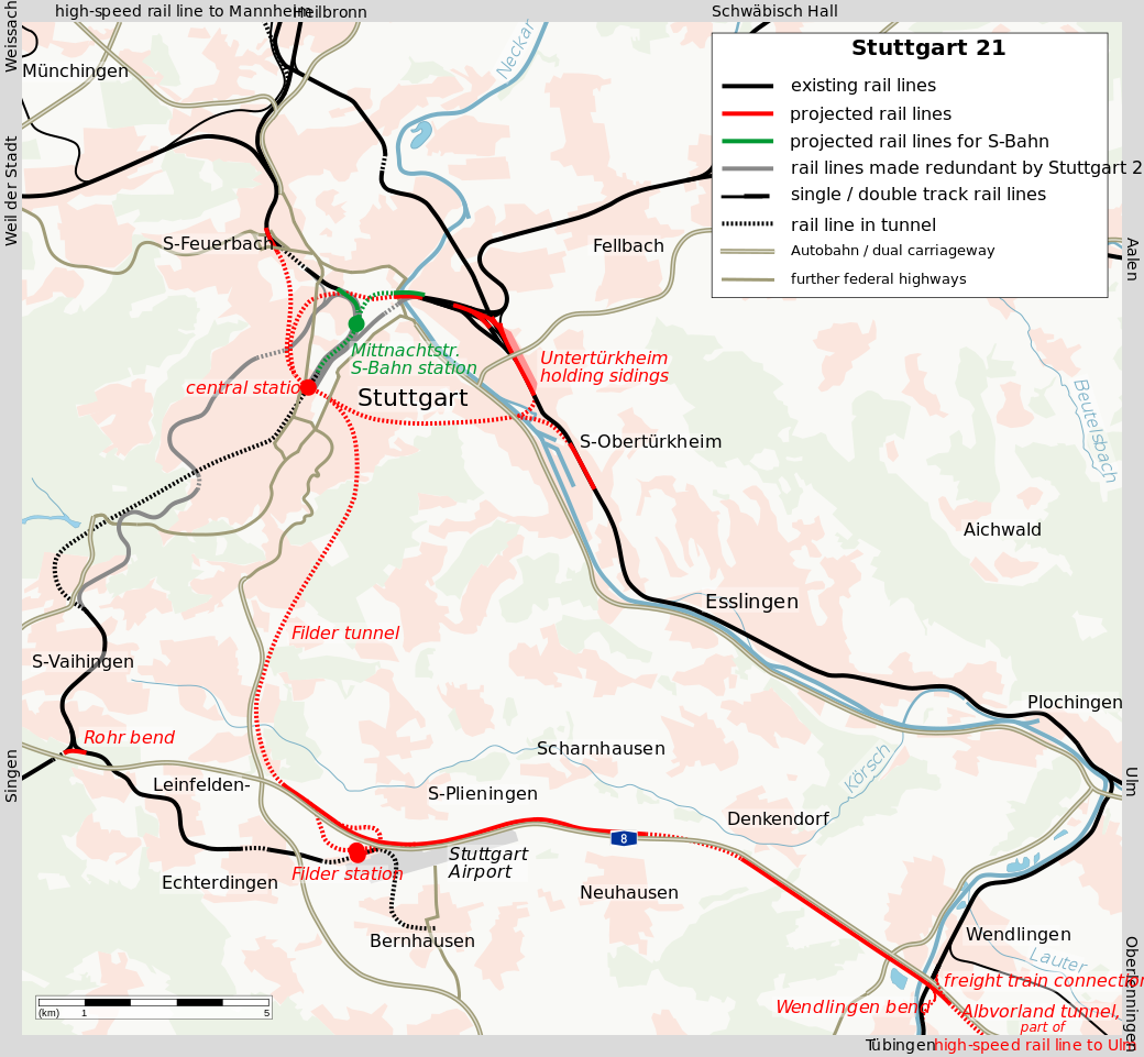
The existing tunnel, oriented in a northeast-southwest direction, is used exclusively by S-Bahn trains. Longer-distance regional trains (“RegionalBahn“) and intercity trains terminate on the surface, and if they continue onward, they must reverse direction.
The new tunnel infrastructure consists of four independent two-track tunnels, two coming in from the northwest and two from the southeast, with full through-service. In addition, an underground loop is to be constructed on the south in order to let trains from points south (Singen) enter Stuttgart via the Filder tunnel while serving the airport at Filder Station without reversing direction. The total double-track tunnel length is 30 kilometers.
Stuttgart 21’s station infrastructure will consist of eight tracks, four in each direction:

The two tracks facing each platform are generally paired with the same approach track, so that in case of service changes, passengers will not be inconvenienced by having to go to a different platform. The interlocking permits trains from each of the two eastern approaches to go to either of the western ones without conflict and vice versa, and the switches are constructed to modern standards, with none of the onerous speed restrictions of American station throats.
So what is the problem?
First of all, the four approach tunnels are not symmetric. The Feuerbach tunnel leads to Mannheim, Frankfurt, Würzburg, and points north, and the Filder tunnel leads to Ulm and points east, including Munich; both are planned to be heavily used by intercity trains. In contrast, the other two tunnels lead to nothing in particular. The Obertürkheim tunnel leads to the current line toward Ulm, but the under-construction high-speed line to Ulm feeds Filder instead, leaving Obertürkheim with just a handful of suburbs.
On the Deutschlandtakt diagram for Baden-Württemberg, every hour there are planned to be 12 trains entering Stuttgart from the Feuerbach tunnel, 10.5 from the Filder tunnel, 5.5 from the Bad Cannstatt tunnel, and 6 from the Obertürkheim tunnel. For the most part, they’re arranged to match the two busier approaches with each other – the track layout permits a pair of trains in either matching to cross with no at-grade conflict, but only if trains from Feuerbach match with Filder and trains from Bad Cannstatt match with Obertürkheim are both station tracks facing the same platform available without conflict.
A train every five minutes through a single approach tunnel feeding two station tracks is not normally a problem. The S-Bahn, depicted on the same map in black, runs 18 trains per hour in each direction through the tunnel; bigger cities, including Paris and Munich, run even more frequent trains on the RER or S-Bahn with just a single station platform per approach track, as on any metro network.
However, the high single-track, single-direction frequency is more suitable on urban rail than on intercity rail. On a metro, trains rarely have their own identity – they run on the same line as a closed system, perhaps with some branching – so if a train is delayed, it’s possible to space trains slightly further apart, so the nominal 30 trains per hour system ends up running 28 trains if need be. On an S-Bahn this is more complicated, but there is still generally a high degree of separation between the system and other trains, and it’s usually plausible to rearrange trains through the central tunnel. On intercity rail, trains have their own identity, so rearrangement is possible but more difficult if for example two trains on the same line, one express and one local, arrive in quick succession. As a result, one platform track per approach track is unsuitable – two is a minimum, and if more tracks are affordable then they should be built.
How do you intend to run the trains?
If the paradigm for intercity rail service is to imitate shorter-range regional trains, then through-tunnels are both easier and more desirable. A relatively closed system with very high frequency between a pair of stations calls for infrastructure that minimizes turnarounds and lets trains just run in the same sequence.
The Shinkansen works this way, leveraging three key features: its near-total isolation from the legacy train network, running on a different gauge; the very high demand for trains along individual corridors on specific city pairs; and the generally high punctuality of Japanese trains even on more complex systems. As it happens, Tokyo is a terminal, with trains going north and south but not through, as a legacy of the history of breaking up Japan National Railway before the Shinkansen reached Tokyo from the north, with different daughter companies running in each direction. However, Shin-Osaka is a through-station, fitting through-trains as well as terminating trains on just eight tracks.
In the developed world’s second busiest intercity rail network, that of Switzerland, the paradigm is different. In a country whose entire population is somewhat less than that of Tokyo without any of its suburbs, no single corridor is as strong as the Shinkansen corridors. Trains form a mesh with timed connections every hour, sometimes every half hour. Intercity trains are arranged to arrive at Zurich, Bern, and Basel a few minutes before the hour every 30 minutes and depart a few minutes later. In that case, more approach tracks and more platform tracks are needed. Conversely, the value of through-tracks is diminished, since passengers can transfer between trains more easily if they can walk between platforms without changing grade.
Infrastructure-timetable integration
Germany aims to integrate the infrastructure and timetable, as Switzerland does. However, Stuttgart 21 is a failure of such integration. The Deutschlandtakt service paradigm calls for many trains entering and leaving the station within the span of a few minutes. Today there are four effective approaches with two tracks each, same as under the Stuttgart 21 plan, but they are better-distributed.
The idea of Stuttgart 21, and similar proposals for Frankfurt and Munich, is solid provided that the intention is to run trains the Japanese way. It Stuttgart were designed to be the junction of two consistently high-intensity lines, then it would work without additional infrastructure. But it is not: its approach tunnels are supposed to support such design, but the service pattern will not look this way because of how the tunnels are placed relative to Germany’s population distribution. Even highly competent engineering can produce incompetent results if the details do not match the big picture.
S-Bahn and RegionalBahn
The American rail activist term regional rail refers to any mainline rail service short of intercity, which lumps two distinct service patterns. In some German cities, these patterns are called S-Bahn and RegionalBahn, with S-Bahn referring to urban rail running on mainline tracks and RegionalBahn to longer-range service in the 50-100 km range and sometimes even beyond. It’s useful to distinguish the two whenever a city wishes to invest in its regional rail network, because the key infrastructure for the two patterns is different.
As with many this-or-that posts of mine, the distinction is not always clear in practice. For one, in smaller cities, systems that are labeled S-Bahns often work more like RegionalBahn, for example in Hanover. Moreover, some systems have hybrid features, like the Zurich S-Bahn – and what I’ve advocated in American contexts is a hybrid as well. That said, it’s worth understanding the two different ends of this spectrum to figure out what the priority for rail service should be in each given city.
S-Bahn as urban rail
The key feature of the S-Bahn (or the Paris RER) is that it has a trunk that acts like a conventional urban rapid transit line. There are 6-14 stations on the trunks in the examples to keep in mind, often spaced toward the high end for rapid transit so as to provide express service through city center, and all trains make all stops, running every 3-5 minutes all day. Even if the individual branches run on a clockface schedule, people do not use the trunk as a scheduled railroad but rather show up and go continuously.
Moreover, the network layout is usually complementary with existing urban rail. The Munich S-Bahn was built simultaneously with the U-Bahn, and there is only one missed connection between them, The Berlin S-Bahn and U-Bahn were built separately as patchworks, but they too have one true missed connection and one possible miss that depends on which side of the station one considers the crossing point to be on. The RER has more missed connections with the Metro, especially on the RER B, but the RER A’s station choice was designed to maximize connections to the most important lines while maintaining the desired express stop spacing.
Urban rail lines rarely terminate at city center, and the same is true for S-Bahn lines. In cities whose rail stations are terminals, such as Paris, Munich, Frankfurt, and Stuttgart, there are dedicated tunnels for through-service; London is building such a tunnel in Crossrail, and built one for Thameslink, which has the characteristics of a hybrid. In Japan, too, the first priority for through-running is the most local S-Bahn-like lines – when there were only six tracks between Tokyo and Ueno, the Yamanote and Keihin-Tohoku Lines ran through, as did the Shinkansen, whereas the longer-range regional lines terminated at the two ends until the recent through-line opened.
The difference between an S-Bahn and a subway is merely that the subway is self-contained, whereas the S-Bahn connects to suburban branches. In Tokyo even this distinction is blurred, as most subway lines connect to commuter rail lines at their ends, often branching out.
RegionalBahn as intercity rail
Many regional lines descend from intercity lines that retooled to serve local traffic. Nearly every trunk line entering London from the north was built as a long-range intercity line, most commuter rail mainlines in New York are inner segments of lines that go to other cities or used to (even the LIRR was originally built to go to Boston, with a ferry connection), and so on.
In Germany, it’s quite common for such lines to maintain an intercity characteristic. The metropolitan layout of Germany is different from that of the English-speaking world or France. Single-core metro regions are rather small, except for Berlin. Instead, there are networks of independent metropolitan cores, of which the largest, the Rhine-Ruhr, forms an urban complex almost as large as the built-up areas of Paris and London. Even nominally single-core metro regions often have significant independent centers with long separate histories. I blogged about the Rhine-Neckar six months ago as one such example; Frankfurt is another, as the city is ringed by old cities including Darmstadt and Mainz.
But this is not a purely German situation. Caltrain connects what used to be two independent urban areas in San Francisco and San Jose, and many outer ends of Northeastern American commuter lines are sizable cities, such as New Haven, Trenton, Providence, and Worcester.
The intercity characteristic of such lines means that there is less need to make them into useful urban rail; going express within the city is more justifiable if people are traveling from 100 km away, and through-running is a lower priority. Frequency can be lower as well, since the impact of frequency is less if the in-vehicle travel time is longer; an hourly or half-hourly takt can work.
S-Bahn and RegionalBahn combinations
The S-Bahn and RegionalBahn concepts are distinct in history and service plan, but they do not have to be distinct in branding. In Paris, the distinction between Transilien and the RER is about whether there is through-running, and thus some lines that are RegionalBahn-like are branded as RER, for example the entire RER C. Moreover, with future extension plans, the RER brand will eventually take over increasingly long-distance regional service, for example going east to Meaux. Building additional tunnels to relieve the worst bottlenecks in the city’s transport network could open the door to connecting every Transilien line to the RER.
Zurich maintains separate brands for the S-Bahn and longer-distance regional trains, but as in Paris, the distinction is largely about whether trains terminate on the surface or run through either of the tunnels underneath Hauptbahnhof. Individual S-Bahn branches run every half hour, making extensive use of interlining to provide high frequency to urban stations like Oerlikon, and many of these branches go quite far out of the city. It’s not the same as the RER A and B or most of the Berlin S-Bahn, with their 10- and 15-minute branch frequencies and focus on the city and innermost suburbs.
But perhaps the best example of a regional rail network that really takes on lines of both types is that of Tokyo. In branding, the JR East network is considered a single Kanto-area commuter rail network, without distinctions between shorter- and longer-range lines. And yet, the rapid transit services running on the Yamanote, Keihin-Tohoku, and Chuo-Sobu Lines are not the same as the highly-branched network of faster, longer-range lines like Chuo Rapid, Yokosuka, Sobu Rapid, and so on.
The upshot is that cities do not need to neatly separate their commuter rail networks into two separate brands as Berlin does. The distinction is not one of branding for passengers, but one of planning: should a specific piece of infrastructure be S-Bahn or RegionalBahn?
Highest and best use for infrastructure
Ordinarily, the two sides of the spectrum – an S-Bahn stopping every kilometer within the city, and a RegionalBahn connecting Berlin with Magdeburg or New York with New Haven – are so different that there’s no real tradeoff between them, just as there is no tradeoff between building subways and light rail in a city and building intercity rail. However, they have one key characteristic leading to conflict: they run on mainline track. This means that transportation planners have to decide whether to use existing mainline tracks for S-Bahn or RegionalBahn service.
Using different language, I talked about this dilemma in Boston’s context in 2012. The situation of Boston is instructive even in other cities, even outside the United States, purely because its commuter rail service is so bad that it can almost be viewed as blank slate service on existing infrastructure. On each of the different lines in Boston, it’s worth asking what the highest and best use for the line is. This really boils down to two questions:
- Would the line fill a service need for intra-urban travel?
- Does the line connect to important outlying destinations for which high speed would be especially beneficial?
In Boston, the answer to question 1 is for the most part no. Thirty to forty years ago the answer would have been yes for a number of lines, but since then the state has built subway lines in the same rights-of-way, ignorant of the development of the S-Bahn concept across the Pond. The biggest exceptions are the Fairmount Line through Dorchester and the inner Fitchburg Line through suburbs of Cambridge toward Brandeis.
On the Fairmount Line the answer to question 2 is negative as well, as the line terminates within Boston, which helps explain why the state is trying to invest in making it a useful S-Bahn with more stops, just without electrification, high frequency, fare integration, or through-service north of Downtown Boston. But on the Fitchburg Line the answer to question 2 is positive, as there is quite a lot of demand from suburbs farther northwest and a decent anchor in Fitchburg itself.
The opposite situation to that of Fairmount is that of the Providence Line. Downtown Providence is the largest job center served by the MBTA outside Boston; the city ranks third in New England in number of jobs, behind Boston and Cambridge and ahead of Worcester and Hartford. Fast service between Providence and Boston is obligatory. However, Providence benefits from lying on the Northeast Corridor, which can provide such service if the regional trains are somewhat slower; this is the main justification for adding a handful of infill stops on the Providence Line.
In New York, the situation is the most complicated, befitting the city’s large size and constrained location. On most lines, the answers to both questions is yes: there is an urban rail service need, either because there is no subway service (as in New Jersey) or because there is subway service and it’s overcrowded (as on the 4/5 trains paralleling the Metro-North trunk and on the Queens Boulevard trains paralleling the LIRR trunk); but at the same time, there are key stations located quite far from the dense city, which can be either suburban centers 40 km out or, in the case of New Haven, an independent city more than 100 km out.
Normally, in a situation like New York’s, the solution should be to interline the local lines and keep the express lines at surface terminals; London is implementing this approach line by line with the Crossrail concept. Unfortunately, New York’s surface terminals are all outside Manhattan, with the exception of Grand Central. Penn Station has the infrastructure for through-running because already in the 1880s and 90s, the ferry transfers out of New Jersey and Brooklyn were onerous, so the Pennsylvania Railroad invested in building a Manhattan station fed by east-west tunnels.
I call for complete through-running in New York, sometimes with the exception of East Side Access, because of the island geography, which makes terminating at the equivalent of Gare du Nord or Gare de Lyon too inconvenient. In other cities, I might come to different conclusions – for example, I don’t think through-running intercity trains in Chicago is a priority. But in New York, this is the only way to guarantee good regional rail service; anything else would involve short- and long-range trains getting in each other’s way at Penn Station.
Deutschlandtakt and Country Size
Does the absolute size of a country matter for public transport planning? Usually it does not – construction costs do not seem to be sensitive to absolute size, and the basics of rail planning do not either. That Europe’s most intensely used mainline rail networks are those of Switzerland and the Netherlands, two geographically small countries, is not really about the inherent benefits of small size, but about the fact that most countries in Europe are small, so we should expect the very best as well as the very worst to be small.
But now Germany is copying Swiss and Dutch ideas of nationally integrated rail planning, in a way that showcases where size does matter. For decades Switzerland has had a national clockface schedule in which all trains are coordinated for maximum convenience of interchange between trains at key stations. For example, at Zurich, trains regularly arrive just before :00 and :30 every hour and leave just after, so passengers can connect with minimum wait. Germany is planning to implement the same scheme by 2030 but on a much bigger scale, dubbed Deutschlandtakt. This plan is for the most part good, but has some serious problems that come from overlearning from small countries rather than from similar-size France.
In accordance with best industry practices, there is integration of infrastructure and timetable planning. I encourage readers to go to the Ministry of Transport (BMVI) and look at some line maps – there are links to line maps by region as well as a national map for intercity trains. The intercity train map is especially instructive when it comes to scale-variance: it features multihour trips that would be a lot shorter if Germany made a serious attempt to build high-speed rail like France.
Before I go on and give details, I want to make a caveat: Germany is not the United States. BMVI makes a lot of errors in planning and Deutsche Bahn is plagued by delays; these are still basically professional organizations, unlike the American amateur hour of federal and state transportation departments, Amtrak, and sundry officials who are not even aware Germany has regional trains. As in London and Paris, the decisions here are defensible, just often incorrect.
Run as fast as necessary
Switzerland has no high-speed rail. It plans rail infrastructure using the maxim, run trains as fast as necessary, not as fast as possible. Zurich, Basel, and Bern are around 100 km from one another by rail, so the federal government invested in speeding up the trains so as to serve each city pair in just less than an hour. At the time of this writing, Zurich-Bern is 56 minutes one-way and the other two pairs are 53 each. Trains run twice an hour, leaving each of these three cities a little after :00 and :30 and and arriving a little before, enabling passengers to connect to onward trains nationwide.
There is little benefit in speeding up Switzerland’s domestic trains further. If SBB increases the average speed to 140 km/h, comparable to the fastest legacy lines in Sweden and Britain, it will be able to reduce trip times to about 42 minutes. Direct passengers would benefit from faster trips, but interchange passengers would simply trade 10 minutes on a moving train for 10 minutes waiting for a connection. Moreover, drivers would trade 10 minutes working on a moving train for 10 minutes of turnaround, and the equipment itself would simply idle 10 minutes longer as well, and thus there would not be any savings in operating costs. A speedup can only fit into the national takt schedule if trains connect each city pair in just less than half an hour, but that would require average speeds near the high end of European high-speed rail, which are only achieved with hundreds of kilometers of nonstop 300 km/h running.
Instead of investing in high-speed rail like France, Switzerland incrementally invests in various interregional and intercity rail connections in order to improve the national takt. To oversimplify a complex situation, if a city pair is connected in 1:10, Switzerland will invest in reducing it to 55 minutes, in order to allow trains to fit into the hourly takt. This may involve high average speeds, depending on the length of the link. Bern is farther from Zurich and Basel than Zurich and Basel are from each other, so in 1996-2004, SBB built a 200 km/h line between Bern and Olten; it has more than 200 trains per day of various speed classes, so in 2007 it became the first railroad in the world to be equipped with ETCS Level 2 signaling.
With this systemwide thinking, Switzerland has built Europe’s strongest rail network by passenger traffic density, punctuality, and mode share. It is this approach that Germany seeks to imitate. Thus, the Deutschlandtakt sets up control cities served by trains on a clockface schedule every 30 minutes or every hour. For example, Erfurt is to have four trains per hour, two arriving just before :30 and leaving just after and two arriving just before :00 and leaving just after; passengers can transfer in all directions, going north toward Berlin via either Leipzig or Halle, south toward Munich, or west toward Frankfurt.
Flight-level zero airlines
Richard Mlynarik likes to mock the idea of high-speed rail as conceived in California as a flight-level zero airline. The mockery is about a bunch of features that imitate airlines even when they are inappropriate for trains. The TGV network has many flight-level zero airline features: tickets are sold using an opaque yield management system; trains mostly run nonstop between cities, so for example Paris-Marseille trains do not stop at Lyon and Paris-Lyon trains do not continue to Marseille; frequency is haphazard; transfers to regional trains are sporadic, and occasionally (as at Nice) TGVs are timed to just miss regional connections.
And yet, with all of these bad features, SNCF has higher long-distance ridership than DB, because at the end of the day the TGVs connect most major French cities to Paris at an average speed in the 200-250 km/h range, whereas the fastest German intercity trains average about 170 and most are in the 120-150 range. The ICE network in Germany is not conceived as complete lines between pairs of cities, but rather as a series of bypasses around bottlenecks or slow sections, some with a maximum speed of 250 and some with a maximum speed of 300. For example, between Berlin and Munich, only the segments between Ingolstadt and Nuremberg and between Halle and north of Bamberg are on new 300 km/h lines, and the rest are on upgraded legacy track.
Even though the maximum speed on some connections in Germany is the same as in France, there are long slow segments on urban approaches, even in cities with ample space for bypass tracks, like Berlin. The LGV Sud-Est diverges from the classical line 9 kilometers outside Paris and permits 270 km/h 20 kilometers out; on its way between Paris and Lyon, the TGV spends practically the entire way running at 270-300 km/h. No high-speed lines get this close to Berlin or Munich, even though in both cities, the built-up urban area gives way to farms within 15-20 kilometers of the train station.
The importance of absolute size
Switzerland and the Netherlands make do with very little high-speed rail. Large-scale speedups are of limited use in both countries, Switzerland because of the difficulty of getting Zurich-Basel trip times below half an hour and the Netherlands because all of its major cities are within regional rail distance of one another.
But Germany is much bigger. Today, ICE trains go between Berlin and Munich, a distance of about 600 kilometers, in just less than four hours. The Deutschlandtakt plan calls for a few minutes’ speedup to 3:49. At TGV speed, trains would run about an hour faster, which would fit well with timed transfers at both ends. Erfurt is somewhat to the north of the midpoint, but could still keep a timed transfer between trains to Munich, Frankfurt, and Berlin if everything were sped up.
Elsewhere, DB is currently investing in improving the line between Stuttgart and Munich. Trains today run on curvy track, taking about 2:13 to do 250 km. There are plans to build 250 km/h high-speed rail for part of the way, targeting a trip time of 1:30; the Deutschlandtakt map is somewhat less ambitious, calling for 1:36, with much of the speedup coming from Stuttgart21 making the intercity approach to Stuttgart much easier. But with a straight line distance of 200 km, even passing via Ulm and Augsburg, trains could do this trip in less than an hour at TGV speeds, which would fit well into a national takt as well. No timed transfers are planned at Augsburg or Ulm. The Baden-Württemberg map even shows regional trains (in blue) at Ulm timed to just miss the intercity trains to Munich. Likewise, the Bavaria map shows regional trains at Augsburg timed to just miss the intercity trains to Stuttgart.
The same principle applies elsewhere in Germany. The Deutschlandtakt tightly fits trains between Munich and Frankfurt, doing the trip in 2:43 via Stuttgart or 2:46 via Nuremberg. But getting Munich-Stuttgart to just under an hour, together with Stuttgart21 and a planned bypass of the congested Frankfurt-Mannheim mainline, would get Munich-Frankfurt to around two hours flat. Via Nuremberg, a new line to Frankfurt could connect Munich and Frankfurt in about an hour and a half at TGV speed; even allowing for some loose scheduling and extra stops like Würzburg, it can be done in 1:46 instead of 2:46, which fits into the same integrated plan at the two ends.
The value of a tightly integrated schedule is at its highest on regional rail networks, on which trains run hourly or half-hourly and have one-way trip times of half an hour to two hours. On metro networks the value is much lower, partly because passengers can make untimed transfers if trains come every five minutes, and partly because when the trains come every five minutes and a one-way trip takes 40 minutes, there are so many trains circulating at once that the run-as-fast-as-necessary principle makes the difference between 17 and 18 trainsets rather than that between two and three. In a large country in which trains run hourly or half-hourly and take several hours to connect major cities, timed transfers remain valuable, but running as fast as necessary is less useful than in Switzerland.
The way forward for Germany
Germany needs to synthesize the two different rail paradigms of its neighbors – the integrated timetables of Switzerland and the Netherlands, and the high-speed rail network of France.
High investment levels in rail transport are of particular importance in Germany. For too long, planning in Germany has assumed the country would be demographically stagnant, even declining. There is less justification for investment in infrastructure in a country with the population growth rate of Italy or of last decade’s Germany than in one with the population growth rate of France, let alone one with that of Australia or Canada. However, the combination of refugee resettlement and a very strong economy attracting European and non-European work migration is changing this calculation. Even as the Ruhr and the former East Germany depopulate, we see strong population growth in the rich cities of the south and southwest as well as in Berlin.
The increased concentration of German population in the big cities also tilts the best planning in favor of the metropolitan-centric paradigm of France. Fast trains between Berlin, Frankfurt, and Munich gain value if these three cities grow in population whereas the smaller towns between them that the trains would bypass do not.
The Deutschlandtakt’s fundamental idea of a national integrated timed transfer schedule is good. However, a country the size and complexity of Germany needs to go beyond imitating what works in Switzerland and the Netherlands, and innovate in adapting best practices for its particular situation. People keep flying domestically since the trains take too long, or they take buses if the trains are too expensive and not much faster. Domestic flights are not a real factor in the Netherlands, and barely at all in Switzerland; in Germany they are, so trains must compete with them as well as with flexible but slow cars.
The fact that Germany already has a functional passenger rail network argues in favor of more aggressive investment in high-speed rail. The United States should probably do more than just copy Switzerland, but with nonexistent intercity rail outside the Northeast Corridor and planners who barely know that Switzerland has trains, it should imitate rather than innovating. Germany has professional planners who know exactly how Germany falls short of its neighbors, and will be leaving too many benefits on the table if it decides that an average speed of about 150 km/h is good enough.
Germany can and should demand more: BMVI should enact a program with a budget in the tens of billions of euros to develop high-speed rail averaging 200-250 km/h connecting all of its major cities, and redo the Deutschlandtakt plans in support of such a network. Wedding French success in high-speed rail and Swiss and Dutch success in systemwide rail integration requires some innovative planning, but Germany is capable of it and should lead in infrastructure construction.
Massachusetts Sandbags Rail Electrification
In the last year, Massachusetts has been studying something called the Rail Vision, listing several alternatives for commuter rail modernization. This has been independent of the North-South Rail Link study, and one of the options that the Rail Vision considered was full electrification. Unfortunately, the report released yesterday severely sandbags electrification, positing absurdly high costs. The state may well understand how bad its report is – at least as of the time of this writing, it’s been scrubbed from the public Internet, forcing me to rely on screencaps.
In short: the alternative that recommends full system electrification was sandbagged so as to cost $23 billion. This is for electrification, systems, and new equipment; the NSRL tunnel is not included. All itemized costs cost a large multiple of their international cost. The Americans in my feed are even starting to make concessions to extremely expensive projects like the Caltrain electrification, since the proposed MBTA electrification is even costlier than that.
But the telltale sign is not the cost of the wires, but rolling stock. The report asserts that running electrified service requires 1,450 cars’ worth of electric multiple units (“EMUs”), to be procured at a cost of $10 billion. More reasonable figures are 800 and $2 billion respectively.
Why 1,450 cars?
The all-electric option assumes that every line in the system will get a train every 15 minutes, peak and off-peak. What counts as a line is not clear, since some of the MBTA’s commuter lines have branches – for example, the Providence and Stoughton Lines share a trunk for 24 km, up to Canton Junction. However, we can make reasonable assumptions about which branches are far enough out; overall rolling stock needs are not too sensitive to these assumptions, as most lines are more straightforward.
The MBTA is capable of turning trains in 10 minutes today. In making schedules, I’ve mostly stuck to this assumption rather than trying to go for 5-minute turnarounds, which happen in Germany all the time (and on some non-mainline American subways); occasionally trains steal 1-2 minutes’ worth of turnaround time, if there’s a longer turn at the other end. Thus, if the one-way trip time is up to 50 minutes, then 8 trainsets provide 15-minute service.
To me, high-frequency regional rail for Boston means the following peak frequencies:
Providence/Stoughton: a train every 15 minutes on each branch. Service south of Providence is spun off to a Rhode Island state service, making more stops and running shorter trains as demand is weaker than commuter volumes to Boston. With this assumption, the Providence Line requires 7-8 trainsets. The Stoughton Line, with the South Coast Rail expansion to New Bedford and Fall River, each served every half hour, requires around 9-10. Say 18 sets total.
Worcester: the big question is whether to exploit the fast acceleration of EMUs to run all-local service or mix local and express trains on tracks in Newton that will never be quadrupled unless cars are banned. The all-local option has trains doing Boston-Worcester in just under an hour, so 9-10 trainsets are required. The mixed option, with a train every 15 minutes in each pattern, and local trains only going as far as Framingham, requires 14 sets, 8 express and 6 local.
Franklin/Fairmount: a train every 15 minutes on the Franklin Line, entering city center via the Fairmount Line, would do the trip in around 50 minutes. It may be prudent to run another train every 15 minutes on the Fairmount Line to Readville, a roughly 17-minute trip by EMU (current scheduled time with diesel locomotives: 30 minutes). Overall this is around 12 trainsets.
Old Colony Lines: there are three lines, serving very low-density suburbs. The only destinations that are interesting for more than tidal commuter rail are Plymouth, Brockton, Bridgewater State, and maybe an extension to Cape Cod. Each branch should get a train every 30 minutes, interlining to a train every 10 from Quincy Center to the north. About 10-12 trainsets are needed (2 more if there’s an hourly train out to Cape Cod); this is inefficient because with three branches, it’s not possible to have all of them depart South Station at :05 and :35 and arrive :25 and :55, so even if there’s a train every 15 minutes per branch, the requirement doesn’t double.
Fitchburg Line: a local train to Wachusett every 15 minutes would require around 12 sets (75 minutes one-way). The number may change a little if there’s an overlay providing service every 7.5 minutes to Brandeis, or if trains beyond South Acton only run every half hour.
Lowell Line: an EMU to Lowell would take about 27 minutes, depending on the stop pattern; 5 trainsets provide 15-minute frequency.
Haverhill Line: an EMU to Haverhill running the current route (not via the Wildcat Branch) would take about 40 minutes, so 7 trainsets provide a train every 15 minutes.
Eastern Lines: like the Old Colony Lines, this system has very low-density outer branches, with only one semi-reasonable outer anchor in Newburyport. Trains should run to Beverly every 10 minutes, and then one third should turn, one third should go to Rockport, and one third should go to Newburyport. With the same inherent inefficiency in running this service on a symmetric schedule as the Old Colony, around 10-12 sets are needed.
This is about 90 sets total. At eight cars per set, and with a spare ratio of 11%, the actual requirement is 800 cars, and not 1,450. The difference with the state’s assumption is likely that I’m assuming trains can run at the acceleration rates of modern EMUs; perhaps the state thinks that EMUs are as slow and unreliable as diesel locomotives, so a larger fleet is necessary to provide the same service.
Rolling stock costs
Reducing the cost of infrastructure is complicated, because it depends on local factors. But reducing the cost of industrial equipment is easy, since there are international vendors that make modular products. Factories all over Europe, Japan, and South Korea make this kind of equipment, and the European factories barely require any modifications to produce for the American market under current federal regulations.
It is not hard to go to Railway Gazette and search for recent orders for EMUs; names of trainsets include Talent, FLIRT, Mireo (cost information here) and Coradia. The linked Coradia order is for €96,500 per meter of train length, the other three orders are for about €70,000. A US-length (that is, 25 meters) car would cost around $2.5 million at this rate. 800 cars times $2.5 million equals $2 billion, not the $10 billion the MBTA claims.
Railway Gazette also discusses a maintenance contract: “Vy has awarded Stadler a contract worth nearly SFr100m for the maintenance in 2020-24 of more than 100 five-car Flirt EMUs.” These trains are 105 meters long; scaled to US car length, this means the annual maintenance cost of an EMU car is around $50,000, or $40 million for the entire fleet necessary for electrified service.
The actual net cost is even lower, since the MBTA needs to replace its rolling stock very soon anyway. If the choice is between 800 EMUs and a larger diesel fleet, the EMUs are cheaper; in effect, the rolling stock cost of electrification is then negative.
Why are they like this?
I struggle to find a problem with Boston’s transportation network that would not be alleviated if Massachusetts’ secretary of transportation Stephanie Pollack and her coterie of hacks, apparatchiks, and political appointees were all simultaneously fired.
There is a chain of command in the executive branch of the Massachusetts state government. Governor Charlie Baker decides that he does not want to embark on any big project, such as NSRL or rail electrification, perhaps because he is too incompetent to manage it successfully. He then intimates that such a project is unaffordable. Secretary Pollack responds by looking for reasons why the project is indeed unaffordable. Under pressure to deliver the required results, the planners make up outrageously high figures: they include fleet replacement in the electrified alternative but not in the unelectrified one (“incremental cost”), and then they lie about the costs by a factor of five.
Good transit activists can pressure the state, but the state has no interest in building good transit. The do-nothing governor enjoys no-build options and multi-billion dollar tweaks – anything that isn’t transformative is good to him. The do-nothing state legislature enjoys this situation, since it is no more capable of managing such a project, and having a governor who says no to everything enables it to avoid taking responsibility.
West Station is an Overbuilt Mess
Boston has been on a commuter rail infill binge lately; it has opened four stations on the Fairmount Line this decade, with general success, and is now eying the Worcester Line, where the MBTA has already opened a single in-city station called Boston Landing. The next station to be opened is called West Station, serving Allston, a middle-class urban neighborhood home to Boston University. Unfortunately, the West Station project has suffered from budget and schedule overruns: the current projection is $90 million, where past stations in the area have opened for about $15-25 million each, and construction will start next decade and only wrap up by 2040.
The cause of the extreme cost is poor design. The station as currently proposed is an overbuilt mess. It is development-oriented transit, sited next to an area that Harvard wishes to redevelop as a new campus, and the compromises made between good rail service, intermodal bus-rail connections, and encouraging development make the project fail at all of its objectives. The idea of an infill station in Allston is solid and the MBTA should keep working on the project, but it should do it right – that is, maximize passenger utility while also slashing the budget by a factor of about 4.
I encourage readers to look at a presentation about the status of the project from May, and at another presentation from June, which was sent to members of the media and neighborhood.
Intermodal integration done wrong
The West Station site is roughly in the center of the new development. Unfortunately, it is poorly-located relative to the street network. With its hierarchy of major and minor streets, Boston is not forgiving to wrong station siting: buses would have to meander to reach the site.
The busiest bus in the area, and among the busiest in the region, is the 66. See image below:

The Red and Green Lines of the subway are in their respective colors (and the Green Line’s branches are surface light rail), the Worcester Line is in purple with its existing stations marked alongside the proposed West Station site, and the 66 bus is in black. The dashed purple line is the disused Grand Junction Railroad – see below for more explanation.
North of the West Station site, the bus could still reach the platforms relatively easily, as the plan includes mapping new streets over the entire site. But to the south, the streets are narrow and practically unusable. All north-south through-traffic is funneled through Harvard Avenue – anything else would meander at speeds not much higher than that of walking.
What’s more, the zigzag in the image above comes from a detour to the center of Allston, called Union Square. The West Station site would move service farther away from Union Square, forcing it to either abandon its single busiest stop or have a more circuitous route. Serving both West Station and Union Square requires running two separate north-south bus routes sharing much of their southern legs, which is bad for frequency. Already the 66 runs every 10 minutes off-peak in one direction and every 14 in the other; this is worse than the minimum acceptable on such a key route, and any further reduction in frequency through route splitting is unacceptable.
Finally, the station design as shown in the presentations includes ample room for bus bays, so that buses can terminate at the station. Such a layout may be appropriate at the center of a small town with timed bus-rail transfers; in the middle of the city, it is pointless. The 66 crosses the rail tracks and has no use for terminal berths. Nor is there any need for terminating buses running parallel to the tracks – passengers could walk to another train station on the Worcester Line or on the Green Line.
The MBTA has never released any public plan for a bus redesign around West Station. It talks about intermodal transfers but refuses to give any details, and it’s likely these details don’t even exist yet. There are occasional excuses, such as intercity buses (why would they terminate there instead of continuing to South Station?), buses to Kendall Square (they don’t need bus bays either), and buses to Longwood (Longwood is south of the Worcester Line and would be better-served by a commuter rail-to-Green Line transfer near Fenway Park).
Track design for maximum conflict
The latest option for West Station is called the flip option. The diagrams below are from the June presentation, pp. 8-10, going west to east:
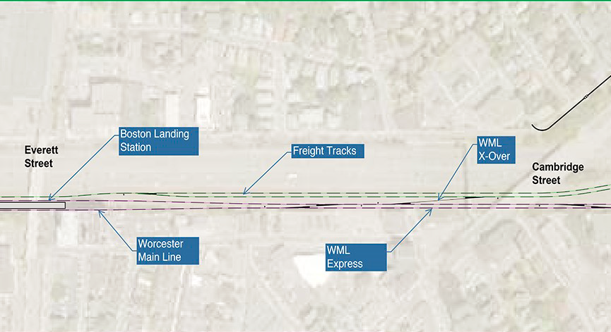
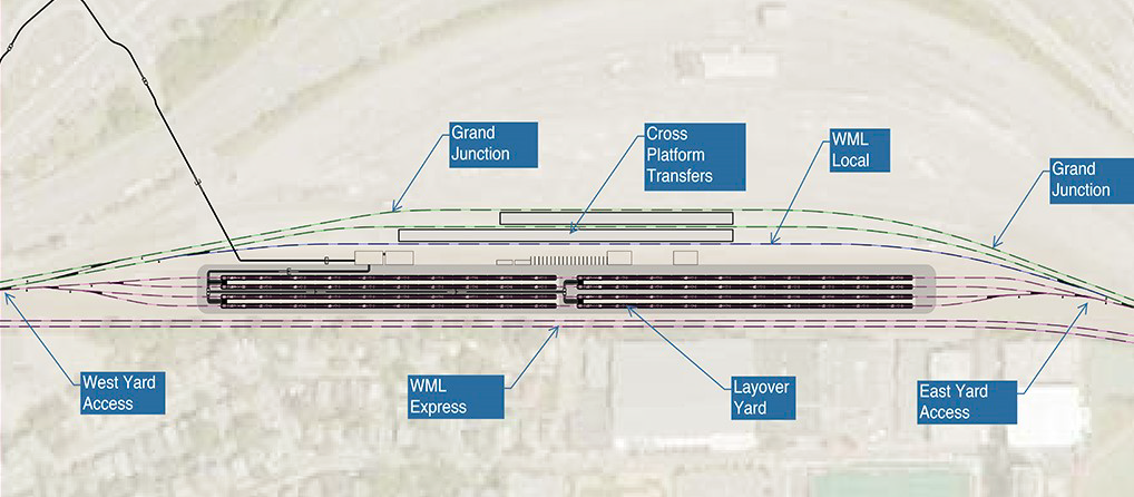
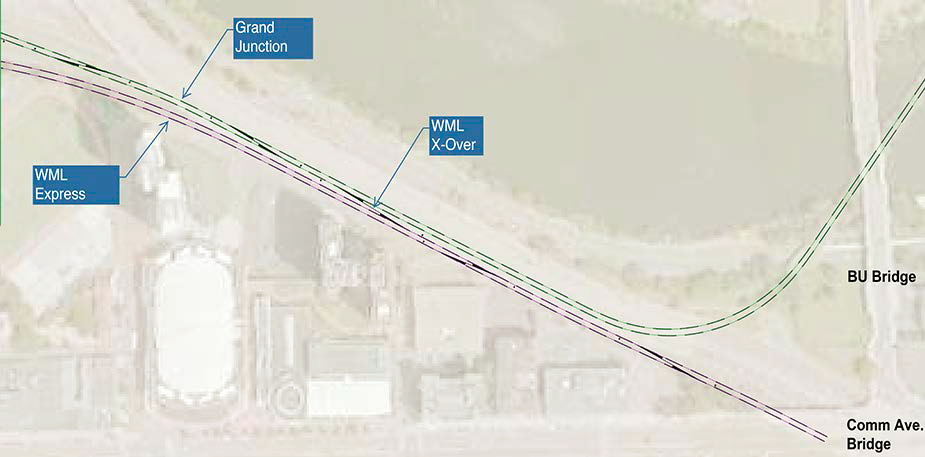
There are to be two bypass tracks (“WML Express”), located where the current mainline is. There are also to be three tracks with station access, both on the other side of the railyard. The tracks serving the platforms cross the bypass tracks in a flat junction, forcing dependency between the inbound and outbound schedule. The flat junction is not especially quick, either – it is a long ladder track, requiring inbound local trains to South Station to make two slow diverging moves in succession.
The MBTA is planning to spend tens of millions of dollars on station platforms in Newton turning the line into full double-track all the way from Boston to Worcester, freeing the schedule from such dependency, but at the same time it’s planning to add new conflicts.
While the diagrams label two tracks as freight tracks, there is little to no freight on that portion of the line. A freight rail spur in the area, serving Houghton Chemical, was just removed in preparation for the project. The line can and should be designed exclusively around the needs of regional passenger trains, for which the most important thing is continuous operation of double track, preferably with no flat junctions with oncoming traffic, and not any ancillary frills.
The Grand Junction tangential
The MBTA has grandiose plans to use the Grand Junction Railroad to allow trains from Allston and points west to avoid South Station entirely. The Grand Junction provides a bypass to the west of Downtown Boston, which currently sees no passenger service but is used for non-revenue moves between the South Station and North Station networks. There are periodic plans to reactive service so as to enable trains from the west to serve Cambridge and North Station instead. In the flip option, all local trains are required to go to the Grand Junction or switch back to the mainline using the ladder track.
Consult the following table, sourced to OnTheMap, for the number of jobs accessible within walking distance of the various station sites:
| Station | Walkshed boundaries | Jobs |
| South Station | Essex, Tremont, State, the harbor | 119,191 |
| Back Bay | Hereford, Belvidere, Columbus, Arlington, Storrow | 62,513 |
| Kendall | Binney, Third, Wadsworth, Memorial, Mass Ave, Windsor, Bristol | 29,248 |
| North Station | Blossom, Cambridge, State, Prince, the river | 33,232 |
Jobs accessible on the existing mainline outnumber ones accessible via the Grand Junction by a factor of about three. It is not technically sound to avoid city center on an urban rail line, much less a suburban one. Only if the line is a consistent circumferential line is there a good reason to go around the center.
A far-future subway duplicating the 66 route may succeed. The same may be true of a shuttle using the Grand Junction, but such shuttle may well need extensive new track – West Station is not necessarily the best south-of-Charles footprint (turning east toward BU to form a loop with a future North-South Rail Link is better). In contrast, the current plan for diversion of Newton trains toward a secondary job center and away from Downtown Boston has no chance of getting substantial ridership.
The railyard as an obstacle
For a project so focused on redevelopment, West Station does not do a good job encouraging construction in the area. It plans to keep the railyard in the middle, and even forces local and express trains to go on opposite sides of it. But the railyard is an obstacle not only to sound railway operations but also to redevelopment.
Building anything over rail tracks is complicated. New York supplies a few such examples: the link mentions the difficulties of Atlantic Yards, and to that I will add that the construction of the Hudson Yards towers cost around $12,000/m^2, compared with $3,000-6,000 for Manhattan supertall office towers on firma. Hudson Yards has managed to be financially successful, albeit with tax breaks, but it’s located right outside Midtown Manhattan. Allston’s location is not so favored. The cost penalty of building over railyards is likely to make air rights unviable.
There is still an extensive portion of the site that’s on firma. However, if the point is to maximize redevelopment potential, the city and the state must discard any plans for air rights. The railyard should go in order to increase the buildable area.
In lieu of parking at a railyard in a desirable near-center location, trains should circulate back and forth between Boston and Worcester. The MBTA keeps saddling itself with capital costs because it likes running trains one-way to Downtown Boston in the morning and then back to the suburbs in the afternoon, parking them near South Station midday. This is bad practice – trains are not just for suburban salarymen’s commutes. Urban infill stations in particular benefit from high all-day frequency and symmetric service. If the MBTA needs space for train parking, it should sell the railyard in Allston and charge Allston land prices, and instead buy space in Framingham and Worcester for Framingham and Worcester land prices.
West Station, done right
Thanks to delays and cost overruns, West Station is still in preliminary design. There is plenty of time to discard the flip option as well as the original plan in favor of a route that maximizes intermodal connections at minimum cost. A better West Station should have all of the following features:
- A simple four-track design, either with two stopping tracks and two bypass tracks or four stopping tracks and two island platforms, depending on long-term plans for train timetables
- High design speed, as high as the rest of the line for nonstop trains, as the tracks are straight and do not require any speed restriction
- Retention of double-track rail service throughout construction, even at the cost of more disruption to the Massachusetts Turnpike
- No at-grade conflicts in opposing directions: tracks should go slow-fast-fast-slow or fast-slow-slow-fast rather than slow-slow-fast-fast
- No bus bays: crosstown buses (that is, the 66) should stop on the street crossing the station right above the tracks, with vertical circulation directly from the bus stop to the platform in order to minimize transferring time
- Subject to site availability, platforms reaching Cambridge Street for a connection to the present-day 66 and a shorter walk to Union Square
- Elimination of the railyard to make more room for development, and if the line needs more yard space, then the state should find cheaper land for it in Framingham and Worcester
There is no reason for such a project to cost more than past infill stations built in Boston, which have cost around $15-25 million, about the same range as Berlin. By removing unnecessary scope, the MBTA can make West Station not only cheaper and easier to build but also more useful for passengers. The idea of an infill commuter rail station in Allston is good and I commend the MBTA for it, but the current plan is overbuilt and interferes with good rail and bus operations and needs to be changed immediately, in advance of engineering and construction.
Assume Nordic Costs: London Edition
A month ago I made maps proposing some subway and regional rail extensions in New York and noting what they would cost if New York could build as cheaply as the Scandinavian capitals. Here is the same concept, but with London rather than New York. Here is everything in a single large map:
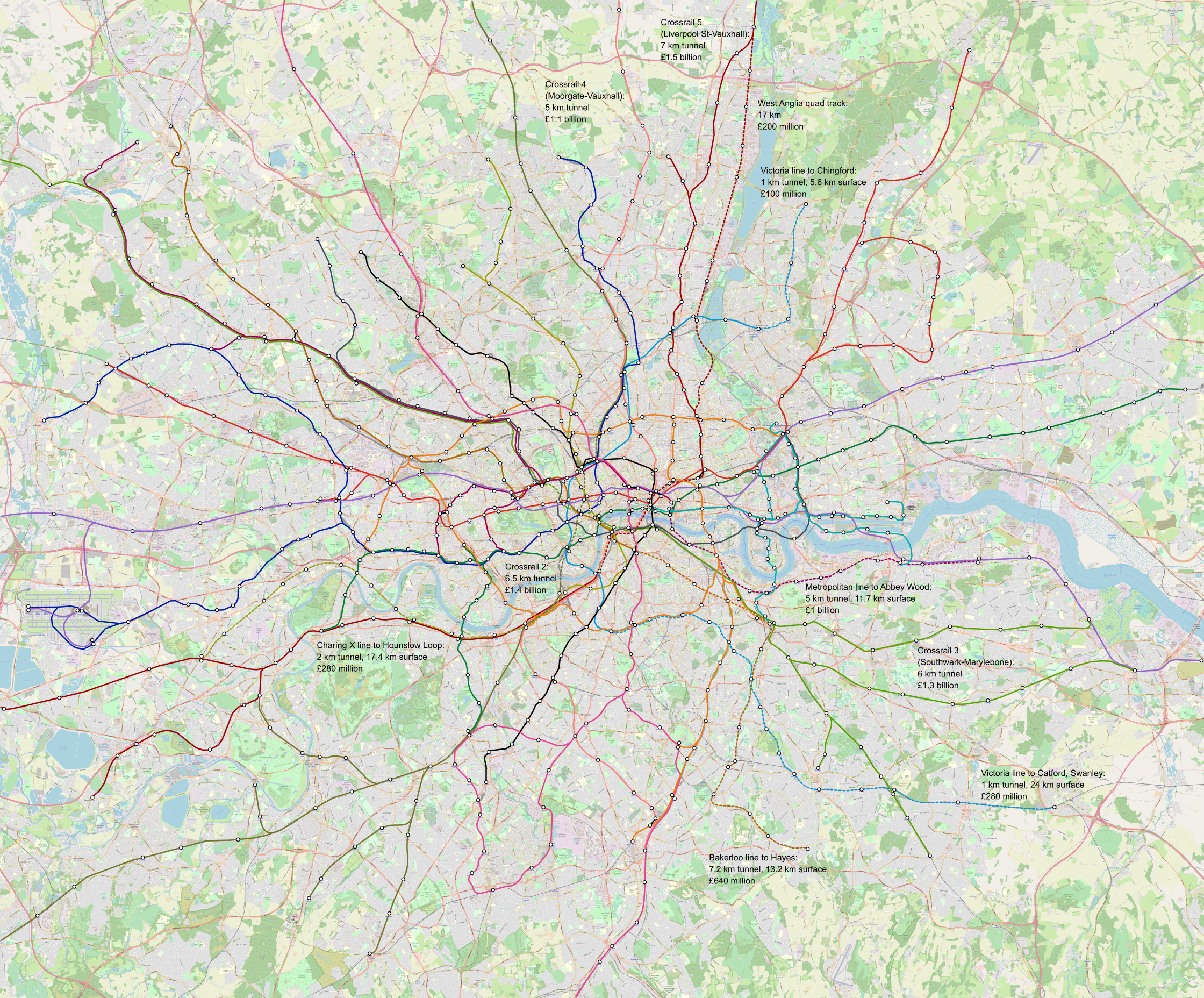
A full-size (74 MB) map can be viewed here.
Solid lines are existing or under construction, that is Crossrail and the Battersea extension; proposed lines are dashed. Commuter rail lines, that is Thameslink, the soon-to-open Crossrail, and four additional Crossrail tunnels labeled 2 through 5, are always depicted as having separate stations from the other modes, to avoid confusion where one Crossrail station has connections to two adjacent Tube stations (such as Farringdon-Barbican and Moorgate-Liverpool Street). It has many additional interchanges between lines and branches, including some that were left out on purpose, like a Crossrail 1 connection to Oxford Circus, omitted from the under-construction line to discourage riders from using the oversubscribed Victoria line; with four more cross-city lines, the capacity problems would be lessened substantially.
The overall picture is sparser than my New York map. The total projected cost of all of these projects, including some allocated for redoing stations on commuter branches to be given to Tube lines, is £6.8 billion, compared with $37 billion for the New York maps. The reason is that unlike New York, London already has excellent coverage thanks to extensive branching – what it needs is core capacity, which consists of city center tunnels that have high cost per kilometer but need not be long.
There is considerable overbuilding planned in London. Crossrail 2 as depicted on my map is a 6.5 km tunnel between the approach to Victoria Station and the approach to Kings Cross. But as planned, Crossrail 2 extends to a long tunnel parallel to the South West Main Line, a four-track line in a right-of-way that could if truly necessary accommodate six, as well as a long tunnel going north to take over the Lea Valley Lines, which on my map go into Crossrail 5. With gratuitous suburban tunnels and extremely high British construction costs, the budget for Crossrail 2 is around £30 billion, about 20 times what Scandinavia might spend on such a project. Even allowing for the possibility that crossing under three lines at once at Bank is more complex than crossing under two at T-Centralen, this is a difference of a full order of magnitude, counting both total required tunnel length and cost per km.
In addition, there is network simplification. On the Tube this consists of segregating the Northern line’s Bank and Charing Cross branches (already in planning pending the Battersea extension and reconstruction of Camden Town) and through breaking the Circle line into separate Metropolitan and District lines. The latter was estimated by a British blogger to cost £5 billion, based on a rubric in which the Met/District transfer at Aldgate (or Tower Hill) should by itself cost £1 billion; Crossrail and Second Avenue Subway stations cost around half that much, and the more complex T-Centralen and Odenplan stations on Citybanan cost less.
On mainline rail, the service plan is supposed to be deinterlined, as is Transport for London’s long-term goal. The slow tracks of the various mainlines feeding into Central London turn into Crossrail branches, or occasionally Underground extensions, such as Hayes and the Hounslow Loop. The fast tracks stay on the surface to avoid interfering with high-frequency regional metro service. For historic reasons Thameslink mostly stays as-is, with a combination of fast and stopping services, but the curve toward London Bridge should not be used – instead, passengers should have access to Crossrail 3 plus interchanges to the City at London Bridge and a new infill station at Southwark.
London owes it to itself to understand why its construction costs are so high that instead of solving its transport capacity problems with multiple cross-city tunnels in a decade, it’s taking multiple generations to build out such a system. There’s a lot of ongoing discussion about the last-minute delays and cost overruns on Crossrail, but the absolute costs even before the overrun were very high, the highest in the world outside New York City – and Crossrail 2 is set to break that record by a margin.