Category: Urban Transit
Cities With Underbuilt Public Transportation
There’s a number of very big cities in middle-income countries that don’t really have strong public transport, and I’d like to go over some of their features. The archetype for this urban form is Bangkok, but I think this is pretty common in much of Latin America too, it’s ubiquitous in Southeast Asia except in Singapore, and Cairo has it too and I suspect most of the rest of Africa will as it moves into the middle income category. I’m fairly certain in what I am saying as far as Southeast Asia is concerned, following Paul Barter’s thesis; in Turkey I am less certain, and in Latin America and Egypt I am speculating. Of note, while those regions have some shared features, one feature that is not shared is cost: while Southeast Asian construction costs are very high, Latin American ones are not, and Turkish ones are very low. Of course low costs enable Turkey to build more subways, but it’s only doing so right now as it’s converging to the high income category.
Density with cars
Bangkok is a dense city. It is not to be confused with Hong Kong, but it is not to be confused with Atlanta either. That said, the density has not much structure, similar to the situation of Los Angeles – there is no single central business district, just a big central area with sub-districts with high-rise office and residential towers. Private vehicle ownership is high, and as of 2014, the modal split (source, PDF-p. 44) was 58% car and motorcycle (trending up), 37% bus (falling rapidly), 5% metro (trending up).
My understanding is that this pattern is also how cities like Manila, Lahore, Karachi, and Jakarta look, and even São Paulo, which has a decent-size metro system with pretty high ridership but it’s still undersized for how big the region is. Dhaka (which is low- rather than middle-income) and Cairo have especially high residential densities.
Slow metro expansion
All of these cities are building urban rail, but not particularly quickly (except Istanbul, where costs are unusually low). Bangkok is adding a few lines, but even under current plans will keep having an underbuilt system. The same is true for plans in Manila, Jakarta, Lahore, Cairo, and low-income Dhaka. In most of Latin America, too, expansion is pretty slow – the only city where I’ve seen really fast expansion recently relative to size is Santiago, which is both approximately the richest in the region and also has below-average construction costs.
The slow construction is an important feature. Some cities build quickly and can transition toward reliance on public transport. For example, Taipei only began building its MRT network in the 1990s, long after the most similar capital city to it in overall development history, Seoul, had had a multi-line network. It was a city of motorcycles in the 1990s and so were the other Taiwanese cities, but through fast (albeit expensive) construction has become a transit city, developing higher-intensity central business districts at key MRT junctions and turning its older unstructured density into a structured one.
I am also excluding India from this analysis for the same reason. Indian cities are making enormous mistakes in metro construction, chief of which are poor integration with suburban rail and high construction costs, but they are building, and even keep a lid on costs by building mostly elevated systems. The Delhi Metro ridership is flagging, but it’s a big system, about the same size as New York or London, and it’s expanding quickly; the rest of India is still only catching up, but the plan for Mumbai in 10 years is extensive. Tehran is in the same basket as Indian megacities, judging at least by its healthy pace of metro expansion.
Car domination
Even when most people do not own cars or even motorcycles, as was the case in Thailand until recently, the government prefers cars to public transport. This comes from the fact that unless the public transport is excellent, or only serves where the middle class works, richer people will use cars more than poorer people, and tilt government policy to their preferences. Lagos, for example, was seriously considering banning its jitneys in 2017, called danfos, even as car ownership was 150 per 1,000 people, and has periodically considered such a ban a few times since.
This domination exists even in very poor cities. Years ago, a cousin who was visiting Kampala described its traffic to me as a brutal pecking order in which cars fear trucks and pedestrians fear cars. If 5% of the population owns cars, that’s still the richest 5%, and they get to dictate the rules.
Is it governance?
Something most of those cities I’m describing have in common is a form of government called anocracy. It’s defined as an intermediate form between democracy and autocracy, but really should mean a system in which there is unclear authority – perhaps there are elections but they are not truly free, perhaps there is a deep state, perhaps there is a dictator but the dictator’s power is circumscribed by powerful magnates and norms that do permit some political criticism. Anocracies tend not to have very strong states – a strong state under a dictator rapidly becomes a stable autocracy, for example Russia’s transition to autocracy in the last 20 years under Putin, whereas a strong democratic state evolves enduring norms and institutions of civil liberties and pluralism, like Taiwan and South Korea starting in the 1990s.
I suspect there may be a connection here: anocracies do not really have the state planning ability to restrain local magnates, like these top 10-20% of the population who are drivers. They can build roads, because it takes much less state capacity to incrementally expand roads, often with local sponsorship, than to plan a multi-line metro system, let alone do the clever multimodal design integration between infrastructure and timetabling that Switzerland does.
This is not a perfect correlation. Egypt is autocratic and not anocratic, although its recent military coup suggests it may not be as stable as autocracies with full civilian control of the military like Russia and China. Vietnam appears even more stable, and showcased high state capacity through excellent management of the corona crisis (though coup-ridden Thailand has had an excellent response as well). Moreover, there is no correlation between anocracy and construction costs – even putting my finger on the scales and classifying Turkey as not-anocratic, the correlation between a dummy that takes the value 1 at what I think are non-Turkish anocracies and construction costs is 0.06.
That said, there may be something to the fact that we see rapid expansion of metro systems in a developing country with relatively strong democratic institutions, i.e. India, and saw such expansion in turn-of-the-millennium Taiwan, and likewise we also see rapid expansion in relatively stable autocracies like Iran and China, but we see much less of it in countries without strong governments. And Moscow’s fast metro growth in Russia’s anocratic phase in the 1990s and early 2000s can be excused as having some strong-state planning institutions, inherited from the USSR. Egypt in contrast never had these institutions, with its imperfect state control of the military.
Integrated Timed Transfer Schedules for Buses
I’ve written a bunch about integrated timed transfer (ITT) scheduling based on Swiss and Dutch principles, developed for intercity and regional trains. Here, for example, is how this schema would work for trains connecting Boston and Worcester. But I’ve also seen interest in how buses can connect to one another, so I feel it’s useful to try to adapt the ITT to this different mode. Two particular places where I’ve seen this interest are a statewide plan for intercity buses in West Virginia, and regional integration around Springfield and the Five Colleges; I’m not going to make specific recommendation for either place, since I don’t know them nearly well enough, but I hope what I write will be helpful there and elsewhere.
The ITT principles for trains
ITT for trains relies on total coordination of all aspects of planning. The centerpiece of this is the triangle of infrastructure, rolling stock, and timetable, all of which must be planned together. Decisions on infrastructure spending should be based on what’s required to run the desired schedule, based on tight turnarounds, maximal utilization rates of equipment, and timed connections.
The even broader principle is to trade state complexity for money. It’s harder to plan everything together – different departments need to talk to one another, planning has to be lean or else the back-and-forth will take too long, regulations may have to be adjusted, government at all levels has to push in the same direction. The reason to do this chore is that it’s far cheaper than the alternative. Organization is cheaper than electronics and concrete at all levels; American households spend around 20% of their income on transportation, mostly cars, whereas households in transit cities like Paris or Berlin or Tokyo spend a fraction of that, even taking into account residual car ownership and operating subsidies to public transit.
On buses, there’s no such thing as electronics…
The Swiss maxim, electronics before concrete, concerns trains exclusively. On buses, no such thing exists. It’s not really possible to get higher-performance buses to make a more aggressive schedule. Acceleration rates depend on passenger safety and comfort and not on the motors (in fact, they’re higher on buses than on trains – rubber tires grip the road better than steel wheels grip rails). The closest analog is that electric buses are lower-maintenance, since the diesel engine is the most failure-prone part on buses as well as trains, but what this leads to, IMC, is not really a strategy for improving timetabling – IMC’s main benefits are less pollution and lower maintenance costs.
…but there is a surplus of organization to be done
All the little things that on trains go in the electronics bucket go in the organization bucket on buses. These include the following operating treatments to improve local bus speeds:
- Off-board fare collection
- Stop consolidation to one every 400-500 meters
- Dedicated lanes in congested areas
- Signal priority at busy intersections
In addition, bus shelter does not increase actual speed but does increase perceived speed, and should be included in every bus redesign in an area that lacks it.
These are all present in Eric’s and my Brooklyn bus redesign proposal, but that doesn’t make that proposal an ITT plan – for one, it’s based on 6-minute frequencies and untimed transfers, whereas ITT is based on half-hour frequencies (for the most part) and timed transfers. Of note, in a 6-minute context signal priority should be conditional to prevent bunching, but if buses run on a 30-minute or even 15-minute timetable then bunching is less likely, especially if buses have prepayment and some dedicated lanes.
That said, it’s important to talk about all of the above in this context, because a bus ITT belongs in areas where public transport ridership is so low that people view a bus every 15 minutes as an aspirational schedule. In such areas, the politics of giving buses more priority over cars are harder than in a city with low car usage like Paris or New York or Barcelona. There are some positive examples, like Rhode Island’s eventual passage of a bill giving six key bus corridors signal priority, but in Tampa I was told that DOT wouldn’t even let the bus agency bump up frequency unless it found money for repaving the street with concrete lanes.
What about intercity buses?
Prepayment, stop consolidation, and dedicated lanes are important for speeding up local buses. But intercity buses already stop sporadically, and often run on highways. There, speedup opportunities are more limited.
But there may still be some room for signal priority. If the bus only runs every hour or every half hour, then driver resistance may be reduced, since the vast majority of stoplight cycles at an intersection will not interact with a bus, and therefore the effect of the change on car speed will be small.
This is especially important if buses are to run on arterial roads and not on freeways. The significance is that highways are noisy, especially freeways, and do not have the concept of a station – freeways have exits but one takes an exit in a car, not on foot. Therefore, development does not cluster near a freeway, but rather wants to be a few minutes away from it, to avoid the noise and pollution. Arterials are better at this, though even then, it’s common for American big box stores and malls to be somewhat set away from those, requiring bus passengers to walk through parking lots and access roads.
Arterial roads, moreover, often do have stoplights, with punishing cycles optimized for auto throughput and not pedestrian-friendliness. In such cases, it’s crucial to give buses the highest priority: if these are intercity buses rather than coverage service to a suburb where nobody uses transit, they’re especially likely to be full of passengers, and then a bus with 40 passengers must receive 40 times the priority at intersections of a car with just a driver. Moreover, if it is at all possible to design stoplights so that passengers getting off the wrong side of the street, say on the east side for a northbound bus if the main development is west of the arterial, can cross the street safely.
Designing for reliability
The principles Eric and I used for the Brooklyn redesign, as I mentioned, are not ITT, because they assume frequency is so high nobody should ever look at a timetable. But the ITT concept goes in the exact opposite direction: it runs service every 15, 20, 30, or even 60 minutes, on a consistent clockface schedule (“takt”) all day, with arrival times at stations given to 1-minute precision.
Doing this on a bus network is not impossible, but is difficult. In Vancouver, the bus I would take to UBC, the 84, came on a 12-minute takt off-peak, and ranged between on time and 2 minutes late each cycle; I knew exactly when to show up at the station to make the bus. When I asked Jarrett Walker in 2017 why his American bus redesigns assume buses would run roughly every 15 minutes but not on such a precise schedule, he explained how American street networks, broken by freeways, have more variable traffic than Vancouver’s intact grid of many parallel east-west arterials.
So what can be done?
Dedicated lanes in congested areas are actually very useful here – if buses get their own lanes in town centers where traffic is the most variable, then they can make a consistent timetable, on top of just generally running faster. Signal priority has the same effect, especially on arterials as noted in the section above. Moreover, if the point is to make sure the noon timetable also works at 8:30 in the morning and 5:30 in the afternoon, then driver resistance is especially likely to be low. At 8:30 in the morning, drivers see a bus packed with passengers, and their ability to argue that nobody uses those bus lanes is more constrained.
More on Suburban Circles
In the last post, I criticized the idea of large-radius suburban circle, using the example of the Berlin Outer Ring, at radius 10-26 km from city center. In comments, Andrew in Ezo brought up a very good point, namely that Tokyo has a ring at that radius in the Musashino Line, and ridership there is healthy enough to fill a train every 10 minutes off-peak. Of course, the Musashino Line’s intersections with the main JR East lines, like Nishi-Kokubunji and Minami-Urawa, have the ridership of a city center station in Germany rather than that of a station 25 km out. So to discuss this further, let’s drop midsize cities like Berlin and look at an actually large city: New York. Consider the following possible circle in New York, at radius 20-25 km:
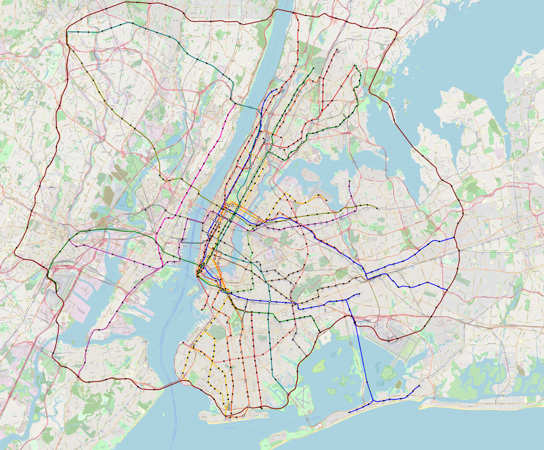
See full-size version here (warning: 55 MB).
Most of the radial extensions I’ve already discussed in previous posts – for example, here. Here these extensions go somewhat further in order to meet the ring, including at Newark Airport, on Staten Island, in Bay Ridge, at Floyd Bennett Park, in Canarsie, at Starrett City, near the Queens/Nassau County line, and in Yonkers.
The ring is 151 km, of which around 87 km would be above ground, mostly replacing highways like the Belt Parkway to reduce costs. Of note, this cannot be done adjacent to an extant highway – the fast car traffic deters nearby development, making transit-oriented development impossible. So key road links around the region have to go, which is fine, since people should be transitioning from driving to taking trains. With some additional elevated construction including through City Island, across the Long Island Sound, and in low-density parts of North Jersey where demolishing houses even at $1 million per unit is cheaper than tunneling, construction costs could be reduced further. But it’s still a $20-25 billion project at average world costs, maybe $15 billion at Nordic or Korean or Southern European or Turkish costs.
The only way to pay off the costs of such a line, not to mention to fill enough trains to support frequency that can take untimed transfers (at worst a train every 10 minutes), is to have very high ridership, on the order of 400,000-500,000 per day. This is for a line that misses Manhattan and all of the big secondary job centers, like Downtown Brooklyn and Long Island City. Is this plausible?
The answer is not an obvious no. Sufficiently aggressive TOD could plausibly create ridership. But it’s still questionable. There are really a few different forces pulling such a line in different directions:
- Using existing rights-of-way to reduce costs, hence the use of the Belt Parkway and not the denser development around Avenue U or even Flatlands.
- Serving secondary nodes like JFK, Coney Island, EWR, and Yonkers. Potentially it would be plausible to veer inward in New Jersey in order to hit Downtown Newark, at the cost of a few extra kilometers of tunnel, making the line radial from Newark’s perspective, whereas the line as depicted above is circumferential from Newark’s perspective since it goes around city center.
- The need to connect to radial subway and commuter rail lines, which means serving stations, opening plausible infill stations, and extending some lines toward the ring.
There are different ways to resolve this tension; the line I depicted is not the only one. For example, a higher-cost, higher-ridership version could veer inward in the Bronx and Queens, aiming to connect to Flushing and Jamaica and then replace the AirTrain JFK, leading to a ring of radius closer to 16 km than to 20-25.
I only bring this up to point out how many things have to work if you want such a ring to work out. Keeping costs to even semi-reasonable levels requires demolishing highways and engaging in aggressive TOD, which is only possible in an environment of total political victory over NIMBY and pro-car interests (note: these two are not the same!).
This is not the history of the Musashino Line. The Musashino Line originates in a freight bypass around the built-up area of Tokyo, which eventually turned into a circumferential passenger line. This is why it connects to the radial lines near but not at the busiest regional stations – at Nishi-Kokubunji and not Kokubunji, at Minami-Urawa and not Urawa, at Shin-Matsudo and not Matsudo or Kashiwa.
But even when the line is new, there are always compromises on right-of-way. Uncompromised right-of-ways are 100% possible, but not at 25 km radius, because the cost is too high to always go to the most important secondary centers. They happen when the radius is smaller, like Paris’s 8-10 km for M15, because then ridership can be high enough (M15 projects nearly a million riders a day). Farther away, ridership drops and costs rise because the line gets longer faster than per-km costs drop, so compromises are inevitable.
I am not proposing the ring above as a definitive crayon. I’m just mentioning it as something that highlights the difficulties of circumferential public transportation in the suburbs. Even as it is, the strongest segment of the ring is most likely the one in the city taking over the Belt Parkway, which could replace busy buses like the B15, B1, B3, B6, and B82. The suburban segments are weaker – there isn’t that much commuting across the Hudson that far north, and building up such commuting requires heavy commercial TOD in Yonkers, Mount Vernon, and New Rochelle.
Overlapping Circles
I’ve been looking at a lot of big city metro maps recently while checking the construction cost database line by line, and I noticed a regrettable pattern in a number of megacities: they’re so big their metro networks have multiple circles in service or under construction, and instead of neat concentric circles they have overlaps.
What are overlapping circles?
Here is Moscow, for example. The map shows three circles: in blue is the Circle Line, or Line 5; in black is the Moscow Central Circle; and in red is the under-construction Big Circle Line, or Line 11.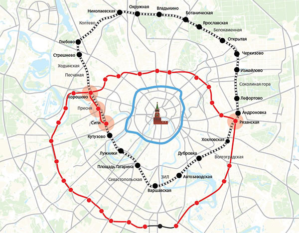
The reason for this is that the Central Circle uses a legacy regional rail alignment. In isolation, with no legacy rail to speak of, circles tend to be more orderly, as in Beijing with its two concentric circles (Lines 2 and 10). However, if there is a legacy alignment, it may not be perfectly aligned with where, absent any legacy rail, it would make the most sense to place an orbital. This is the case above in Moscow: the Central Circle is close to the Circle Line in the south but abuts farther away in the north, and the Big Circle Line is built to be the opposite.
This is not unique to Moscow. Here is Tokyo:

The Oedo Line, in magenta, is a ring with a tail. The Yamanote Line, in light green, is a full ring, taller than it is wide so as to really be two north-south lines joined at both ends.
Why is this bad?
The point of a circumferential line is to provide public transit in the orthogonal direction to that of city center. This has any of the following uses:
- To provide service on strong corridors that happen to be orthogonal to the direction of city center, such as Uptown Manhattan streets, Beijing ring roads, traces of former city walls in Paris, etc.
- To connect strong near-center neighborhoods to one another, at a radius that balances the density close to the center with the greater need for a circumferential farther away to avoid the inconvenience of walking or taking a two-seat ride on radial metro lines.
- To connect outlying areas with strong near-center neighborhoods that lie on different lines.
- To facilitate interchanges between different radial lines, especially ones that are close to each other, without too much backtracking and without overloading central transfer points.
This works best if the circumferential service is at approximately equal radius from the center. If it is not, then some segment of it may be partially radial, which means it will have all of the problems of radials (peakiness) and none of the benefits (service to city center). In extreme cases, an operational circle may literally pass through city center, as is the case for the Yamanote Line, or a nominal circumferential may pass close enough to count, as is the case for the East London line at Shoreditch, and then the problem is that one side of the region doesn’t get any circumferential service, that is Shitamachi and East London.
If there are multiple circles, then all of the above aspects get better if those circles are concentric, for the same reason. Having many circumferential lines closely parallel to each other can create a local grid in an especially large city; I proposed such a system for Lagos, which is both enormous and a tabula rasa.
Why does this keep happening?
The Moscow Central Circle and the Yamanote Line are both historic legacy commuter lines. Paris is in a similar situation, except the legacy is more recent and evolved over a generation: plans for a circumferential line beyond the M2/M6 ring go back generations, but nothing was done until recently, and the first effort in that direction was the early tramways. So there’s an incomplete ring formed by T1 and T2, another incomplete ring formed by T3, and the under construction M15 ring, the M15 ring intersects the T1/T2 ring because the T1/T2 alignments were based on where convenient surface roads or rights-of-way were available.
That this is so common in the largest cities in the world does not mean it is good. Sound prior planning should figure out locations for such circles in advance. In the case of Paris, there could have been the M2/M6 ring, and then the T3 ring beyond it (as a subway, not light rail) replacing the closely parallel Petite Ceinture, which is no longer useful since the radial Métro lines don’t have stops at the correct locations, and then the M15 ring, and then the orbital tramways of the Grande Ceinture. But I’m not going to use the incompetence tag if in the 1980s a city isn’t sure what its rail network will look like in the 2030s.
In a way, it’s like missed connections between metro lines. It comes from bad planning. It’s hard to avoid – the largest metro network without missed connections is Mexico City, which is unusually poor in radial lines, and even networks that have very few of these, like Paris, Beijing, and Seoul, keep building more. Overlapping circles are likewise present in Tokyo, Moscow, and soon Paris, and absent in only one city with multiple circles, the near-tabula rasa Beijing. However, planners should still aim to avoid this network awkwardness, figuring out network designs well in advance that create neat radials with city center meets and concentric circles for circumferential service.
New York as a Six-Minute City
What would it take to improve public transportation in New York so that all or nearly all routes would run at worst even six minutes during midday? Today, frequencies are tailored to individual routes; a bunch of subway lines are a 10-minute city (and the A branches are a 15-minute city), and in Brooklyn, the median midday bus headway is 12 minutes, with wide variations.
The bus origin of six minutes
Six minutes is not an arbitrary number. It comes from Eric’s and my Brooklyn bus redesign; speeding up routes through stop consolidation, dedicated lanes, and off-board fare collection, and pruning and recombining some routes, lets every bus run every six minutes from 6 am to 10 pm all day every day, with higher frequency on those routes that already have it today because they are too busy for just ten buses per hour. We didn’t study the other boroughs as deeply, but a quick doodle suggested the six-minute standard could be met in Manhattan and the Bronx as well, and a Bronx bus grid could even dip into a five-minute city.
Queens is a wildcard and I’m going to disappoint readers by not talking about it. It is clearly possible given the operational treatment we propose to make most of Queens a six-minute city, but at the price of long route spacing in Eastern Queens, and I don’t know what is optimal. It’s a hard question and I’m not going to tackle it unless I’m actually working on a longer-term project to do a Queens bus redesign.
Six minutes on the subway
The subway right now is a 10-minute city. A lettered or numbered route runs every 10 minutes off-peak, sometimes every 12 on Sundays and at night; the busier routes, especially the four that do not share tracks with other routes (1, 6, 7, L), run more frequently, but 10 minutes is the base frequency on large swaths of the network. The A branches in Ozone Park and the Rockaways even run every 15 minutes, but that’s unusual enough – evidently, nowhere else does one letter or number denote a route with its own branches – that it can be excluded.
For comparison, Berlin’s rail network is a 10-minute city, with some outer S-Bahn branches running every 20 minutes. Within the Ring, Berlin is a 5-minute city for the most part, excluding just a two-hour midday dip to 10 minutes on the Ring and 10-minute frequencies on the U1/U3 branches and the practically useless U4 route. Paris makes no effort to run different routes at the same intervals – French rapid transit planning has self-contained lines with their own fleets and schedules, so for example the RER A is on 10-minute off-peak takts and the RER B on 15-minute ones. So frequency there greatly depends on where in the region one lives and on what line. The Métro is a 5-minute city for the most part, as are the intramural RER trunks; intramural buses can be ignored. The suburbs are more or less a 15-minute city.
The reason New York is a 10-minute city on the subway is partly about interlining. The trunks in theory run every 5 minutes or better, but the trains do not come evenly because sometimes trains with different frequencies share the same trunk, and delays propagate easily. Interlining really doesn’t work unless all trains come at the same frequency; this is familiar in German planning, but not in American planning (or French planning, but there’s barely any interlining in Paris).
Putting every subway route on a 10-minute takt, with double service on the four non-interlined services, is possible but would lead to a lot of crowding on the busiest lines. About the worst possible frequency that works for everything is a train every 7.5 minutes; this lets the two A branches run on 15-minute takts, and everything else run on a 7.5-minute takt. But even then, New York has so many missed connections that it’s useful to do better. The six-minute city, matching buses, turns most of Manhattan and inner Brooklyn and Queens into a three-minute city.
Running all trains on the same takt also means timed connections. Trains that run every 5 or 6 minutes can routinely be timetabled to be at predictable places at predictable times, which facilitates local/express transfers on branches, for example in Southern Brooklyn. Even trunk transfers can be timed – 3-minute trains can still run on a timetable, and the most valuable transfers are local/express ones at 96th/Broadway, 125th/St. Nicholas, and 125th/Lex, all far enough north so as to not have the huge tidal crowds of Times Square or Grand Central.
What would it take?
On the buses, just good redesign, as long as the city is willing to exclude Staten Island from the six-minute city. In Queens, some increase in bus service is probably warranted.
On the subway, this requires on the order of 110-120 million revenue train-km a year, which is 1 billion car-km. The current figure is 560 million car-km/year. There is a lot of unnecessary expenditure on the subway, but fixing that requires something a lot deeper than a bus redesign. The cut in operating costs would be to levels that are well within first-world levels, and some of it would just come from better off-peak service making crew scheduling easier, without split shifts or wasted time. But it does require serious changes, especially in maintenance.
Quick Note: Timed Orbital Buses
Outside a city core with very high frequency of transit, say 8 minutes or better, bus and train services must be timetabled to meet each other with short connections as far as possible. Normally, this is done through setting up nodes at major suburban centers where trains and buses can all interchange. For example, see this post from six months ago about the TransitMatters proposal for trains between Boston and Worcester: on the hour every half hour, trains in both directions serve Framingham, which is the center for a small suburban bus system, and the buses should likewise run every half hour and meet with the trains in both directions.
This is a dendritic system, in which there is a clear hierarchy not just of buses and trains, but also of bus stops and train stations. Under the above system, every part of the Framingham area is connected by bus to the Framingham train station, and Framingham is then connected to the rest of Eastern New England via Downtown Boston. This is the easiest way to set up timed rail-bus connections: each individual rail line is planned around takt and symmetry such that the most important nodes can have easy timed bus connections, and then the buses are planned around the distinguished nodes.
However, there’s another way of doing this: a bus can connect two distinct nodes, on two different lines. The map I drew for a New England high- and low-speed rail has an orbital railroad doing this, connecting Providence, Worcester, and Fitchburg. Providence, as the second largest city center in New England, supplies such rail connections, including also a line going east toward Fall River and New Bedford, not depicted on the map as it requires extensive new construction in Downtown Providence, East Providence, and points east. But more commonly, a connection between two smaller nodes than Providence would be by bus.
The orbital bus is not easy to plan. It has to have timed connections at both ends, which imposes operational constraints on two distinct regional rail lines. To constrain planning even further, the bus itself has to work with its own takt – if it runs every half hour, it had better take an integer multiple of 15 minutes minus a short turnaround time to connect the two nodes.
It is also not common for two suburban stations on two distinct lines to lie on the same arterial road, at the correct distance from each other. For example, South Attleboro and Valley Falls are at a decent distance, if on the short side, but the route between them is circuitous and it would be far easier to try to set up a reverse-direction timed transfer at Central Falls for an all-rail route. The ideal distance for a 15-minute route is around 5-6 km; bus speeds in suburbia are fairly high when the buses run in straight lines, and if the density is so high that 5-6 km is too long for 15 minutes, then there’s probably enough density for much higher frequency than every half hour.
The upshot is that connections between two nodes are valuable, especially for people in the middle who then get easy service to two different rail lines, but uncommon. Brockton supplies a few, going west to Stoughton and east to Whitman and Abington. But the route to Stoughton is at 8.5 km a bit too long for 15 minutes – perhaps turning it into a 30-minute route, either with slightly longer connections or with a detour to Westgate (which the buses already take today), would be the most efficient. The routes to Whitman and Abington are 7 km long, which is feasible at the low density in between, but then timetabling the trains to set up knots at both Brockton and Abington/Whitman is not easy; Brockton is an easy node, but then since the Plymouth and Middleborough Lines are branches of the same system, their schedules are intertwined, and if Abington and Whitman are served 15 minutes away from Brockton then schedule constraints elsewhere lengthen turnaround times and require one additional trainset than if they are not nodes and buses can’t have timed connections at both ends.
Planners then have to keep looking for such orbital bus opportunities. There aren’t many, and there are many near-misses, but when they exist, they’re useful at creating an everywhere-to-everywhere network. It is even valuable to plan the trains accordingly provided other constraints are not violated, such as the above issue of the turnaround times on the Old Colony Lines.
Incrementalism in Infrastructure
I was recently asked about the issue of incrementalism in infrastructure, with specific reference to Strong Towns and its position against big projects (e.g. here). It’s useful to discuss this right now in context of calls for a big infrastructure-based federal jobs program in the United States. The fundamental question to answer is, what is the point of incremental projects?
The issue is that the legitimate reason to prefer less ambitious projects is money. If a new subway tunnel costs $5 billion, but you only have the ability to secure $1.5 billion, then you should build what you can for $1.5 billion, which may be a tram rather than a subway, or surface improvements to regional rail instead of a new regional rail tunnel, etc.
A secondary legitimate reason is that even if there is more money, sometimes you get better results out of building something less flashy. This is the electronics-before-concrete approach – in a developed country it’s almost always cheaper to invest in signaling, electrification, and platform upgrades than to build new tunnels. This can look incremental if it’s part of a broader program: for example, if there’s already investment in electrification in the region then extending wires is incremental, so that completing electrification on the commuter rail lines in New York, reopening closed suburban branches in Philadelphia with new wires, and even completing electrification in a mostly-wired country like Belgium and the Netherlands would count.
But the example of electrification in a mostly already electrified place showcases the differences between cost-effectiveness and incrementalism. The same investment – electrification – has a certain cost-effectiveness depending on how much train traffic there is. There’s a second-order effect in that the first line to be electrified incurs the extra cost of two train fleets and the last line has a negative cost in no longer needing two fleets, but this isn’t relevant to first order. Nonetheless, electrifying a system where electrification is already familiar is considered incremental, to the point that there were extensions of electrification in suburban New York in the 1980s and there remain semi-active projects to build more, whereas electrifying one that is currently entirely diesel, like Boston, is locally considered like a once-in-a-generation project.
And that is the real problem. American cities are hardly hotbeds of giant flashy construction. They barely are in highways – big highway construction plans are still done but in suburbs and not anywhere where public transit is even remotely relevant. And transit construction plans are always watered down with a lot of reconstruction and maintenance money; most of the money in the Los Angeles sales tax measures that are sold to the urbanist public as transit measures is not about rail construction, which is why with money programmed through 2060 the region is going to only have one full subway line; an extension of the Red Line on South Vermont is scheduled to open in 2067, partly because construction costs are high but mostly because there are maintenance projects ahead in line.
So in reality, there are two real reasons why incrementalism is so popular in the United States when it comes to transportation, neither of which is legitimate. Both are types of incompetence, but they focus on different aspects of it.
The first reason is incompetence through timidity. Building something new, e.g. rail electrification in Boston or in California, requires picking up new knowledge. The political appointees in charge of transit agencies and the sort of people who state legislators listen to do not care to learn new things, especially when the knowledge base for these things is outside their usual social networks. Can Massachusetts as a state electrify its rail network? Yes. Can it do so cheaply? Also yes. But can the governor’s political appointees do so? Absolutely not, they are incurious and even political people who are not beholden to the governor make excuses for why Massachusetts can’t do what Israel and Norway and New Zealand and Austria and Germany do.
In that sense, incrementalism does not mean prudence. It means doing what has been done before, because the political people are familiar with it. It may not work, but it empowers people who already have political clout rather than sidelining them in favor of politically independent technocrats from foreign countries who might be too successful.
The second reason is incompetence through lack of accountability. This is specific to an approach that a lot of American urbanists have backed, wrongly: fix-it-first, or in its more formal name state of good repair (SOGR). The urbanist emphasis on SOGR has three causes: first, in the 1980s New York had a critical maintenance backlog and neglected expansion in order to fix it, which led to positive outcomes in the 1990s and 2000s; second, in highways, fix-it-first is a good way to argue against future expansion while hiding one’s anti-car ideology behind a veneer of technical prudence; and third, Strong Towns’ specific use case is very small towns with serious issues of infrastructure maintenance costs and not enough residential or commercial demand to pay for them, which it then generalizes to places where there’s more market demand for growth.
In reality, the situation of 1980s’ New York was atypical. Subsequently, the SOGR program turned into a giant money pit, because here was an opportunity to spend enormous sums of capital construction money without ever being accountable to the public in the form of visible expansion. Ask for a new rail line and people will ask why it’s not open – California got egg on its collective face for not being able to build high-speed rail. Ask for SOGR and you’ll be able to brush away criticism by talking about hidden benefits to reliability. Many passengers may notice that trains are getting slower and less reliable but it’s easier in that case to intimidate the public with officious rhetoric that sounds moderate and reasonable.
Incrementalism is fundamentally a method of improving a legitimate institution. The EU needs incremental reform; China needs a democratic revolution. By the same token, in infrastructure, incrementalism should be pushed when, and only when, the status quo with tweaks is superior to the alternatives. (Note that this is not the same as electronics-before-concrete – what Switzerland did with its rail investment in the 1990s was very far-reaching, and had tangible benefits expressed in trip times, timed connections, and train frequency, unlike various American bus redesigns.) Strong Towns does not believe that there’s anything good about the American urban status quo, and yet it, and many urbanists, are so intimidated by things that happened in the 1950s, 60s, and early 70s that they keep pushing status quo and wondering why there is no public transportation outside about eight cities.
Density and Subway Stop Spacing
Normally, the best interstation distance between subway or bus stops does not depend on population density. To resurrect past models, higher overall density means that there are more people near a potential transit stop, but also that there are more people on the train going through it, so overall it doesn’t influence the decision of whether the stop should be included or deleted. Relative density matters, i.e. there should be more stops in areas that along a line have higher density, for example city centers with high commercial density, but absolute density does not. However, there is one exception to the rule that absolute density does not matter, coming from line spacing and transfer placement. This can potentially help explain why Paris has such tight stop spacing on the Métro and why New York has such tight stop spacing on the local subway lines.
Stop spacing and line spacing
The spacing between transit stops interacts with that between transit lines. The reason is that public transportation works as a combined network, which requires every intersection between two lines to have a transfer. This isn’t always achieved in practice, though Paris has just one missed connection on the Métro (not the RER), M5/M14 near Bastille; New York has dozens, possibly as many as all other cities combined, but the lines built before 1930 only have one or two, the 3/L in East New York and maybe the 1/4-5 around South Ferry.
The upshot is that the optimal stop spacing depends on the line spacing. If the line spacing is tight – say this is Midtown Manhattan and there is a subway line underneath Lex/Park, Broadway, 6th, 7th, and 8th – then crossing lines have to have tight stop spacing in order to connect to all of these parallel lines. In the other direction, there were important streetcars on so many important cross-streets that it was desirable to intersect most or ideally all of them with transfers. With so many streetcar lines extending well past Midtown, it is not too surprising that there had to be frequent subway stops.
So why would denser cities have tighter line spacing?
Line spacing and density
The intuitive relationship between line spacing and density is that denser cities need more capacity, which requires them to build more rail lines.
To see this a bit more formally, think of an idealized city on a grid. Let’s say blocks are 100*100 meters, and the planners can figure out the target density in advance when designing the subway network. If the city is very compact, then the subway could even be a grid, at least locally. But now if we expect a low-density city, say 16 houses per block, then the subway grid spacing should be wide, since there isn’t going to be much traffic justifying many lines. As the city densifies, more subway is justifiable: go up to missing middle, which is around 30-40 apartments per block; then to the Old North of Tel Aviv, which would be around 80; then to a mid-rise euroblock, which is maybe 30-40 per floor and 150-200 per block; then finally a high-rise with maybe 500-1,000 apartments.
Each time we go up the density scale, we justify more subway. This isn’t linear – an area that fills 500 apartments per block, which is maybe 100,000 people per km^2, does not get 20 times the investment of an area on the dense side of single-family with 16 houses per block and 5,000 people per km^2. Higher density justifies intensification of service, with bigger and more frequent trains, as well as more crowding. With more subway lines, there are more opportunities for lines to intersect, leading to more frequent stop spacing.
Even if the first subway lines are not planned with big systems in mind, which New York’s wasn’t, the idea of connections to streetcar lines was historically important. A stop every 10 blocks, or 800 meters, was not considered on the local lines in New York early on; however, stops could be every 5 blocks or every 7, depending on the spacing of the major crosstown streets.
Dense blobs and linear density
Line spacing is important to stop spacing not on parallel lines, but crossing lines. If a bunch of lines go north-south close to one another, this by itself says little about the optimal spacing on north-south lines, but enforces tight spacing on east-west lines.
This means that high density encourages tight stop spacing when it is continuous in a two-dimensional area and not just a line. If large tracts of the city are very dense, then this provides justification for building a grid of subway, since the crosstown direction is likely to fill as well; in New York, 125th Street is a good candidate for continuing Second Avenue Subway Phase 2 as a crosstown line for this reason.
In contrast, if dense development follows a linear corridor, then there isn’t much justification for intense crosstown service. If there’s just one radial line, then the issue of line spacing is moot. Even if there are two closely parallel radial lines in the same area, a relatively linear development pattern means there’s no need for crosstown subways, since the two lines are within walking distance of each other. The radial urban and suburban rail networks of Tokyo and Seoul do not have narrow interstations, nor do they have much crosstown suburb-to-suburb service: density is high but follows linear corridors along rapid transit. Dense development in a finger plan does not justify much crosstown service, because there are big low-density gaps, and suburb-to-suburb traffic is usually served efficiently by trips on radial lines with a transfer in city center.
The French Way of Building Rapid Transit
It’s been a while since I last wrote this series, where I covered the American, Soviet, and British traditions of building urban rail. I’d like to return by focusing attention on the French tradition, which has been influential not just within France itself but also to some extent former French colonies, especially Quebec.
An issue I hope to return to soon is the extent to which France has not truly decolonized; former French colonies in Africa, especially the Maghreb, rely on French technical expertise for construction, and often outsource their monetary policy (as with the CFA franc, but Morocco too has a peg to a dollar and euro mix). This matters, because this means the French way of building urban transit is influential in former French colonies in Africa, whereas the British tradition’s impact on India, Nigeria, and so on is limited.
The history of Paris
Like Britain, the USSR, and the US, France has a dominant financial center that its smaller cities aim to imitate. This imitation has been much more extensive than in the US and UK – to the extent that secondary French cities diverge in design principles from the capital, they do things that were fashionable in Paris at the time they built out their rail networks rather than things that were fashionable in Paris when Paris built the Métro. Thus, it is especially valuable to look at the history of urban rail in Paris.
The Paris Métro opened in 1900, as the world’s fifth metro system. Already then, it had a critical feature that the previous four (London, Budapest, Chicago, Glasgow) lacked: it was a centrally planned multi-line system. The city planned a coordinated system of what would become Lines 1-6, in the shape of a # in a circle: Lines 1 and 3 would run east-west, Lines 4 and 5 would run north-south, and Line 2, eventually split into Lines 2 and 6, would run the trace of the wall that delineated the city’s pre-1860 boundary.
The Métro was a municipal effort run by the municipal CMP, designed around the city’s needs, which included not just good transportation but also separation from the working-class suburbs. Whereas the London Underground was mostly technologically compatible with the mainline system, the Métro was deliberately designed not to be, to protect the urban middle class from transport integration with the suburban poor. This led to the following features:
- The trains are extremely narrow, 2.4-2.44 meters wide, compared with about 2.9 m on the mainline; the deep Tube trains in London, held to have the narrowest loading gauge on a standard-gauge railway, are 2.68 m wide.
- The interstation distance is very short, 562 meters on average. Paris is compact and dense and the short interstations are only a real problem in the suburbs.
- The trains run on the right, like French road traffic, whereas French trains run on the left.
- No legacy lines were incorporated into the system, unlike in New York and London, and thus the shape of the network looks much more like how one would design a metro network from scratch and less like how old West London branches or Brooklyn excursion lines looked.
Like New York and Berlin and unlike London, Paris built the Métro cut-and-cover. The lines built before the 1990s all closely follow streets except when they cross the river – and in the 1900s the Line 4 river crossing was the hardest part of the system to build, opening in 1908 whereas the rest of the network had opened by 1906. This was done entirely by hand, forcing the lines to curve where the streets did, which led to two notable warts. First, while most of the system had a design standard of 60 meter curve radii, Line 1 goes down to 40 at Bastille. And second, Line 5, which crosses the Seine on a bridge, cannot serve Gare de Lyon; the engineers could not get it to curve that way while still running through to Gare d’Austerlitz and the Left Bank, so instead the transfer point between Lines 1 and 5 is Bastille, and more recently the RER A and Line 14 both cross Line 5 without a transfer as they run express from Gare de Lyon to Châtelet.
That said, the missed connection between Lines 5 and 14 is the only one in the system, though two more are under construction on Line 14 extensions. Only one among the major metro systems of the world runs entirely without missed connections, the Mexico City Metro, which has unusually low line density in the core and unusually many tangential lines.
The suburbs and the RER
The Métro’s deliberate exclusion of the suburbs made sense from the point of view of a middle-class Parisian in 1900 who was mortally afraid of the working class. But by the 1930s, it was leading to serious design constraints. Further Métro extensions both densified the network and extended it outward, and in the 1930s, lines began to extend past city limits, to such suburbs as Lilas, Issy, Neuilly, and Montreuil. The short interstations made longer extensions infeasible, and some solution involving regional rail was needed.
In 1938, CMP bought and electrified the Ligne de Sceaux, which alone among the Paris commuter lines had reached close to city center, terminating at Jardin du Luxembourg rather than at the farther away rail stations, which are located at or just inside the M2/M6 ring. Then after the war, as suburbanization intensified and commuter traffic at Gare Saint-Lazare grew increasingly congested, CMP’s successor RATP collaborated with SNCF on connecting regional rail branches to form an express system, that is the RER; the Ligne de Sceaux became the southern half of the RER B, while a similar branch going east paired with one of the Saint-Lazare lines to form the RER A. Through-service opened in 1977, roughly at the same time as the German S-Bahn through-tunnels, but the system grew much larger as Paris was and remains far larger than any German city.
But it is not exactly correct to view the RER as identical to a German S-Bahn, or to one of the RER’s inspirations, the Tokyo through-running system. A number of features characterize it, some shared with other urban regional rail systems, some not:
- There are multiple trunk lines through the city, which form something like a coherent network among themselves, and do not share rolling stock. The biggest warts are that the RER B and D share tracks (but no platforms) on one interstation, and that the RER C mostly stays on the Left Bank, legacy of when planning in Paris conceived of the area around Saint-Michel as a central area to be served, where in reality it is decidedly secondary to the CBD stretching from Les Halles to Champs-Elysées.
- It runs largely, though not entirely, on separate tracks from non-RER lines.
- It is locally viewed as deficient to Métro service – researchers who use the RER B to get to IHES think of it as lower-quality, lower-class service than the Métro in the city and its immediate suburbs. I suspect that this is why Grand Paris Express is designed around Métro standards rather than as intensification of RER service, while RER expansion has fallen to the wayside.
- RER-Métro integration is imperfect: the fares are integrated but there are still barriers between RER and Métro platforms, and there are many missed RER-Métro connections, whereas in Berlin the S-Bahn and U-Bahn have only one missed connection between them.
- The interstation is around 2-3 km, but it’s actually slightly longer on the new urban tunnels build for the RER A, B, D, and E than on the legacy lines in the inner suburbs; this feature also exists in a much more extreme form in the United States, but in Berlin and Tokyo it is completely absent.
Exporting Parisian ideas
Parisian metro planning influenced Montreal, Mexico City, and the smaller French cities, in chronological order. We see any of the following features in those cities:
- Rubber-tired metros. This technology was in vogue in postwar Paris, which converted Lines 1, 4, and 11 to it figuring this was just better than steel wheels, and also Line 6, figuring that an elevated line would benefit from a quieter propulsion system.
- Non-radial network design. London and the systems inspired by it, including all Eastern bloc systems, have radial design, with nearly all lines entering a relatively small city center. Paris expanded its #-in-a-circle system to a combination of a radial network and a grid, with a large number of pairs of parallel lines. Mexico City, the largest system inspired by Paris, is rich in tangential lines but has only three lines serving city center, which are by far the three busiest.
- Short interstations, though this is truer domestically than in Montreal and Mexico City.
- Driverless operations. This technology became popular in the 1980s, starting with the Lille Metro, and France has used it on new lines in Paris (M14) and elsewhere (Lyon Line D, both lines in Toulouse), also innovating in converting manual lines to automatic on Paris M1 and now M4. While the Parisian lines are full-size metro lines, the other ones are light metro running shorter vehicles, often with extensive elevated service.
- Separation between regional rail and metro service. Montreal is sufficiently North American to have given up on regional rail entirely, but Lyon and Marseille are investing in better regional rail, run separately from the local urban transit system but with some degree of integration.
- Light rail. France’s modern light rail systems do not originate in Paris – Nantes opened its system in 1985, suburban Paris only in 1992 – but Paris has a notable feature that isn’t common elsewhere in Western Europe: it is a mixed system with some Métro lines and some tram lines filling in the gaps. This mixed system is also present in Lyon, Marseille, and Toulouse, whereas Bordeaux, Strasbourg, and Nice have entirely tram-centric systems. But in no case is there any subway-surface running as in the United States or Germany: lines are either clearly trams or clearly metros, rather than mixtures, and it is the system that is mixed, not the individual line.
Has France decolonized?
Like Britain, France did not take its geopolitical disempowerment at the end of World War Two easily. Both countries have maintained superpower pretensions, decolonizing but trying to treat their former colonies as their spheres of influence as much as possible. In Britain, this relationship broke down – the ex-colonies were being too loud in the Commonwealth, leading the country to seek to join the EU instead. In France, this relationship remains in Africa, and notable not in Southeast Asia, where Vietnam is buildings its urban rail networks with Chinese and Japanese financing.
But France is not just providing financing to infrastructure projects in its former (or current?) African colonies. It has a permanent presence. In researching Arab rail infrastructure, Anan Maalouf has noted that Alstom has had a subsidiary operating in Algeria since 2002, which does not exist elsewhere in the Arab world. This way, French firms maintain close knowledge of the situation in the Maghreb, where incomes and productivity levels are much lower than in France, so that different methods are optimal from those common in rich countries.
Nonetheless, what they build remains noticeably French. For example, the Sfax tramway does not look too different from what Bordeaux or Nice has. The Tunis Métro looks rather like a French tramway system too, despite the name; of note, even though the Tunis Métro branches, and has some underground segments, those segments are not on line trunks and thus the system does not form a subway-surface or Stadtbahn network.
I haven’t gone too much into intercity rail, but it is worth mentioning that Morocco has a high-speed rail system, built with French technical assistance and running TGV equipment.
Does this work?
Yes and no.
The Paris system works. It is not perfect, and in particular the integration between the Métro and the RER could be better; at least one tram line should be a full metro line (a completed T3 ring), and suburban extensions should generally use the RER, with more investment in RER capacity within the city as well. That said, public transport usage is higher in Paris than in its closest comparison, that is London; Paris’s system is also superior in both overall usage and future prospects to that of another megacity in Europe, Moscow. Only Istanbul could potentially do better in the future, in the context of extremely low construction costs.
That said, Paris is a giant that casts a long shadow, which doesn’t always work well for secondary cities. Lyon, Marseille, Toulouse, and the other secondary French cities aren’t too different in modal split from similar-size British cities, and are behind Vancouver, a North American city with extensive postwar growth. German cities in the Lyon size class do a lot better. See for example data here and here.
The weird features of France, like the love for rubber tires, are not that relevant overall, but do point out that France is relatively insular, and mostly adopts domestic ideas developed in Paris rather than ideas from elsewhere in Europe, let alone Asia. (Yes, I know about Japanese influence on the initial RER; however, there have been 50 years of divergence since, same as with German tram-trains and American light rail.) This has been especially problematic with regional rail. France does not have frequent takts anywhere – even Paris only has takt timetables off-peak, running a separate schedule at rush hour, whereas the German takt plan is repeated throughout the day and the peak can only have supplemental service.
The issue is that Paris does not need to think in terms of repeating schedules, because it is so big that the RER trunks run every 5 minutes off-peak. It thinks of the RER as mostly separate trunk lines with dedicated fleets, because the primary problem is train capacity through city center. In Lyon, let alone smaller cities, this is not the main issue. There do exist a handful of individual lines running an off-peak takt elsewhere in France, but integration with urban rail remains imperfect and a comparison with Vienna, Copenhagen, Zurich, Stuttgart, and Hamburg would not be favorable. It matters that, like Britain, France has such a dominant capital that it doesn’t know how to scale down to provide rail service in a metropolitan area where if the transfers aren’t perfectly timed, people won’t ride.
The Problem of Infrastructure Profits
I’m sometimes asked about the private sector’s role in infrastructure. I’ll cover this more broadly in the future, but for now, let me pour some cold water on the idea that a private actor could build an urban rail system for profit. This is a political and not technical problem: it is possible to build a few (but not many) urban rail lines that, at good but not unheard of construction and operating costs, would generate decent financial returns. However, such lines are extremely vulnerable to confiscation of profits by government at all levels, especially the local level. Moreover, it is not possible for a local government to give any credible guarantee of security of property for a private rail line.
Lines and extensions
There is a great many rail lines in the world where new construction can be profitable. For example, Tokyo subway lines turn a profit, and the government is not building more because it demands a minimum of 3% rate of financial return – and Tokyo has high construction costs. Seoul has low costs, and it’s plausible that if Tokyo could build subways at the cost of Seoul, it would go over the 3% threshold. London is roughly breaking even on the Underground, and I think Berlin is on the U-Bahn, so some of the stronger extensions might be profitable too.
However, in such cases, the profitable additions are mostly extensions of existing lines. These can be profitable, but not to a private operator, only to the agency that controls the existing line. Even new lines often come as part of a broader system designed around transfers; for example, a short line under consideration in Tokyo is designed to connect existing rail lines in Central Tokyo with the growing waterfront area. Usually, these lines work best with free transfers, so an independent operator can’t easily build them – it’s possible Tokyo will build the line as an independent one with extra fares for transfers rather than as a Toei subway, but if so this will be unusual by global standards.
That said, there do exist places where an independent actor could build an entirely new line and not have to worry too much about connections. The example I keep going back to is Geary Boulevard in San Francisco, where a line could connect Downtown San Francisco, say around Transbay Terminal (or even Union Square to save money and avoid tunneling under Market Street), with the Outer Richmond. The bus along this route has 57,000 riders per weekday, and the total including closely parallel routes is 110,000. Bus connections are useful, but a subway on Geary could succeed without them. The same is true of connections to the BART and Muni subways at Market Street – free transfers would be really useful, but the San Francisco central business district is strong enough that a private investor might well take the hit on ridership to avoid being too entangled with public governance.
A few more plausible independent lines include the Downtown Relief Line planned for Toronto, an east-west line between Queens and New Jersey via Midtown Manhattan, and and maybe even the dormant U10 for Berlin; U10 is unlikely to work at all without fare integration, but fortunately the Verkehrsverbund Berlin-Brandenburg provides a local mechanism for revenue sharing without getting too entangled in public governance, though even then I don’t think the returns would be high enough to interest a private investor.
Some technically plausible returns
Let’s focus on Geary in San Francisco. Total ridership on or parallel to the route is 110,000 per weekday, but that’s on slow buses. A rapid transit line would get much more than that – 250,000 is plausible on a very frequent driverless train averaging 35 km/h end-to-end. High frequency would also encourage off-peak ridership, but let’s keep the annual-to-weekday ridership ratio at 300, typical of New York, and not the higher figures seen in London, since passengers would have to pay a separate fare to connect to non-CBD destinations. So this is 75 million riders a year.
What’s the plausible average fare? The Richmond is a middle-class neighborhood, but even there, fares significantly above the current Muni rate are likely to discourage ridership. Muni currently charges $2.50 one-way or $81 for a monthly ($98 with BART, but we’re assuming no free transfers). Assuming New York behavior again, a pass holder averages 46 trips a month; averaging with occasional riders, let’s say this is $2/trip, or $150 million a year.
Against this, what’s the operating cost? If 75 million trips a year average 5 km (half the route length), and there are 30 passengers per car (the New York subway average, and 20% more than the commuter-oriented BART average), this is 12.5 million car-km per year. This is equivalent to 19 5-car trains per hour in each direction 18 hours a day every day. The non-New York first-world range of operating costs is $4-7.5 per car-km as of 2014, but none of the systems studied in the report is all or even mostly driverless, and entirely driverless operations as in Vancouver would reduce costs to the low end of this range. So make it around $50 million a year in operating costs, plus maybe $8 million in depreciation on rolling stock – and let’s even bump it up a bit to $70 million because the maintenance workers are local, even if everything else can be offshored, and San Francisco wages are high. So, $80 million in operating profits per year.
Finally, the construction costs. This is a 10 km line, so at the global median of construction costs this is $2.5 billion. But Scandinavia, Southern Europe, and Korea are all capable of substantially below-median construction – and Nordic working-class wages aren’t necessarily lower than Californian ones. $1.5 billion is plausible, and even $1 billion is ambitious but not outside the realm of possibility if the line only runs to Union Square, not Transbay Terminal.
Profiting $80 million a year on $1.5 billion in investment is thus plausible, giving somewhat better returns than 5%. There’s risk inherent in the figure – costs may escalate, ridership may disappoint, operating costs may be higher than expected. All three happened almost from the dawn of rail technology – they all were rampant in the Railway Mania. The good news is that there is also some upside – office growth in the center of San Francisco could generate more demand, and mass upzoning in the Richmond could happen and was recently a near-miss in the state legislature.
Nonetheless, 5% returns at this level of risk, given decent confidence in one’s cost control, are still reasonable. However…
The government will confiscate profits
Unfortunately for any prospective private investor, the city and state governments have a large toolkit with which to confiscate all profits:
- Impact fees – such a subway would have positive impact on the neighborhood, but the city can still find grounds to levy fees.
- Nuisance suits – groups can invent grounds to sue on and demand bribes (“community benefits”) in exchange for dropping the suit.
- Construction regulations demanding more expensive methods that are (or seem) less disruptive, e.g. a ban on the use of cut-and-cover even for stations.
- Requirements that all workers be unionized and that nothing be outsourced, even things that can be done remotely like the control center.
- Rules calling all new housing construction along the line a benefit to the company, for which the company has to pay a fee.
- Unfunded mandates for fare discounts for seniors, children, the poor, and other groups; the city can pay these discounts out of its own budget, but why not claw into the profits of a private rail operator?
- Hearings at the inevitable objections (someone is always unhappy) in which legislators demand personal favors (“community benefits,” again) in exchange for a yes vote.
The operating requirements, like the unfunded discount mandate, can always be imposed in the future in case the operator profits more than expected. This means that there is not much upside – if profits are higher, there will be more confiscation. The effective profit rate net of the cost of compliance with regulations approaches zero. It may well be negative – the city has every interest in driving a private operator that just spent $1.5 billion of its own money on a subway into liquidation, buy out the infrastructure, and operate service itself.
This in fact happened in New York in the 1920s and 30s. Starting under Mayor John Hylan, the city used regulatory denials to deliberately drive the private streetcar companies out of business. Simultaneously, through the construction of the IND to compete with the private IRT and BMT subways and through denial of a fare hike from 5 cents a ride to 10 cents even after post-WW1 inflation halved the value of the dollar, the city did the same to the private subway operators; the IRT went bankrupt in the Depression, and in 1940 the city bought it and the BMT out.
Obedience, emigration, or the graveyard
The state, or any actor more powerful than you, always offers you this choice. The meaning of obedience is flexible (the political opposition in a democracy is still obedient), and the meaning of the graveyard is usually not literal (“you’ll never work in this town again,” not “you will be killed”). But the choice is still this.
The main way of avoiding the graveyard, emigration, is not available here. Subways are physically fixed infrastructure. If a local government doesn’t like you, you can’t take your capital and move somewhere else. For this reason, owners of tangible property, like small business owners, have had anti-socialist politics going back to the emergence of socialism as a real political force around the Paris Commune, whereas skilled workers didn’t mind socialism as much.
Modifying the meaning of obedience is possible in a place with stronger norms of rule of law. In a capitalist country, earning a profit and paying the normal corporate tax rather than 100% is obedience – the risk is not federal confiscation but state or local confiscation, where the United States never established such norms, relying on the threat of capital flight to lower-tax, lower-regulation states to discipline governments.
I brought up the example of Berlin because I think that here the threat of local confiscation is smaller (but not zero – witness the rent control bill), but even then it’s unlikely to be a 250,000 riders/10 km line – it’s probably a breakeven line or slightly better, ideal for public but not private construction. For the most part, the subway lines that can be profitably built in the EU have already been built; there aren’t huge cities here with unique construction cost problems, except London, where I don’t think there’s an even semi-decent case for any rail line that’s not an extension of existing lines (counting Crossrail as an inward extension of suburban lines).
However, within the US and probably also Canada, even a well-capitalized corporation can’t really modify the meaning of obedience to include profitably constructing urban infrastructure. It can only emigrate, which in this case means knowing not to allocate capital to fixed infrastructure in the first place. Even if apparent returns beat the market, which I don’t think they do, the real returns will be zero so long as state and local governments remain as they are.