Category: Urban Transit
Venture Capital Firms Shift to Green Infrastructure
Several Bay Area major venture capital firms announce that they will shift their portfolios toward funding physical green infrastructure, including solar and wind power generation, utility lines, hydroelectric dams, environmental remediation projects for dams, and passenger and freight rail.
One founder of a firm in the public transit industry, speaking on condition of anonymity because the deal is still in process, points out that other VC investments have not been successful in the last 10-15 years. Cryptocurrencies, NFTs, and other blockchain technologies have not succeeded in transforming the finance sector; the Metaverse flopped; AI investments in driverless cars are still a long way from deployment, while LLMs are disappointing compared with expectations of artificial general intelligence. In contrast, the founder explains, there are great opportunities for new passenger rail lines and renewable and at places nuclear power.
Another founder points out the example of Brightline West and says that with upcoming reforms in permitting, pushed by many of the same VCs, it will be profitable to complete new domestic and international intercity rail lines between cities; a $15 billion investment in connecting Chicago, Detroit, and Cleveland is underway.
On Sand Hill Roads, VC attitudes to the new investment are jubilant. One VC admits to never having heard much about public transit, but, after a three-day factfinding mission can tell you everything you could possibly want to know about the Singapore MRT. Other VCs say that Peter Thiel and Mark Zuckerberg are both especially interested in funding public transit initiatives after Elon Musk retweeted the X account TruthSeeker1488 saying that public transit is a conspiracy by international finance communists.
Subway-Intercity Rail Connections
Something Onux said in comments on yesterday’s post, about connecting Brooklyn to intercity rail, got me thinking more about how metro lines and intercity rail can connect better. This matters for mature cities that build little infrastructure like New York or Berlin, but also for developing-world cities with large construction programs ahead of them. For the most part, a better subway system is automatically one that can also serve the train station better – the train station is usually an important destination for urban travel and therefore, usually the same things that make for a stronger subway system also make for better subway-intercity rail connections.
Subways and commuter trains
Like gender, transit mode is a spectrum. There are extensive systems that are clearly metro and ones that are clearly commuter rail, but also things in between, like the RER A, and by this schema, the Tokyo and Seoul subways are fairly modequeer.
The scope of this post is generally pure subway systems – even the most metro-like commuter lines, like the RER A and the Berlin S-Bahn, use mainline rail rights-of-way and usually naturally come to connect with intercity train stations. Of note, RER A planning, as soon as SNCF got involved, was modified to ensure the line would connect with Gare de Lyon and Gare Saint-Lazare; previous RATP-only plans had the line serving Bastille and not Gare de Lyon, and Concorde and not Auber. So here, the first rule is that metro (and metro-like commuter rail) plans should, when possible, be modified to have the lines serve mainline train stations.
Which train stations?
A city designing a subway system should ensure to serve the train station. This involves nontrivial questions about which train stations exactly.
On the one hand, opening more train stations allows for more opportunities for metro connections. In Boston, all intercity trains serve South Station and Back Bay, with connections to the Red and Orange Lines respectively. In Berlin, north-south intercity trains call not just at Hauptbahnhof, which connects to the Stadtbahn and (since 2020) U5, but also Gesundbrunnen and Südkreuz, which connect to the northern and southern legs of the Ringbahn and to the North-South Tunnel; Gesunbrunnen also has a U8 connection. In contrast, trains into Paris only call at the main terminal, and intercity trains in New York only stop at Penn Station.
On the other hand, extra stations like Back Bay and delay trains. The questions that need to be answered when deciding whether to add stations on an intercity line are,
- How constructible is the new station? In New York, this question rules out additional stops; some of the through-running plans involve a Penn Station-Grand Central connection to be used by intercity trains, but there are other reasons to keep it commuter rail-only (for example, it would make track-sharing on the Harlem Line even harder).
- How fast is the line around the new station? More stations are acceptable in already slow zones (reducing the stop penalty), on lines where most trips take a long time (reducing the impact of a given stop penalty). Back Bay and Südkreuz are in slow areas; Gesundbrunnen is north of Hauptbahnhof where nearly passengers are going south of Berlin, so it’s free from the perspective of passengers’ time.
- How valuable are the connections? This depends on factors like the ease of internal subway transfers, but mostly on which subway lines the line can connect to. Parisian train terminals should in theory get subsidiary stations because internal Métro transfers are so annoying, but there’s not much to connect to – just the M2/M6 ring, generally with no stations over the tracks.
Subway operations
In general, most things that improve subway operations in general also improve connectivity to the train station. For example, in New York, speeding up the trains would be noticeable enough to induce more ridership for all trips, including access to Penn Station; this could be done through reducing flagging restrictions (which we briefly mention at ETA), among other things. The same is true of reliability, frequency, and other common demands of transit advocates.
Also in New York, deinterlining would generally be an unalloyed good for Penn Station-bound passengers. The reason is that the north-south trunk lines in Manhattan, other than the 4/5/6, either serve Penn Station or get to Herald Square one long block away. The most critical place to deinterline is at DeKalb Avenue in Brooklyn, where the B/D/N/Q switch from a pattern in which the B and D share one track pair and the N and Q share another to one in which the B and Q share a pair and the D and N share a pair; the current situation is so delicate that trains are delayed two minutes just at this junction. The B/D and N/Q trunk lines in Manhattan are generally very close to each other, so that the drawback of deinterlining is reduced, but when it comes to serving Penn Station, the drawback is entirely eliminated, since both lines serve Herald Square.
If anything, it’s faster to list areas where subway service quality and subway service quality to the train station specifically are not the same than to list areas where they are:
- The train station is in city center, and so circumferential transit, generally important, doesn’t generally connect to the station; exceptions like the Ringbahn exist but are uncommon.
- If too many lines connect to the one station, then the station may become overloaded. Three lines are probably fine – Stockholm has all three T-bana lines serving T-Centralen, adjacent to the mainline Stockholm Central Station, and there is considerable but not dangerous crowding. But beyond that, metro networks need to start spreading out.
- Some American Sunbelt cities if anything have a subway connection to the train station, for example Los Angeles, without having good service in general. In Los Angeles, the one heavy rail trunk connects to Union Station and so does one branch of the Regional Connector; the city’s problems with subway-intercity rail connections are that it doesn’t really have a subway and that it doesn’t really have intercity rail either.
Land Use Around the Interborough Express
Eric and Elif are working on a project to analyze land use around the corridor of the planned Interborough Express line in New York. The current land use is mostly residential, and a fascinating mix of densities. This leads to work on pedestrian, car, and transit connectedness, and on modal split. As might be expected, car ownership is fairly high along the corridor, especially near the stations that are not at all served by the subway today, as opposed to ones that are only served by radial lines. Elif gave a seminar talk about the subject together with João Paulouro Neves, and I’d like to share some highlights.
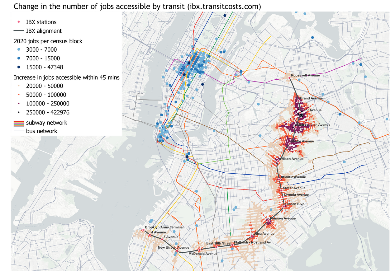
The increase in transit accessibility in the above map is not too surprising, I don’t think. Stations at both ends of the line gain relatively little; the stations that gain the most are ones without subway service today, but Metropolitan Avenue, currently only on the M, gains dramatically from the short trip to Roosevelt with its better accessibility to Midtown.
More interesting than this, at least to me, is the role of the line as a way to gradually push out the boundary between the transit- and auto-oriented sections of the city. For this, we should look at a density map together with a modal split map.

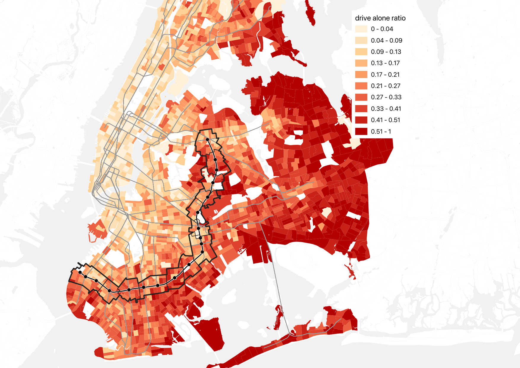
At the seminar talk, Elif described IBX as roughly delineating the boundary between the auto- and transit-oriented parts of the city, at least in Brooklyn. (In Queens, the model is much spikier, with ribbons of density and transit ridership along subway lines.) This isn’t quite visible in population density, but is glaring on the second map, of modal split.
Now, to be clear, it’s not that the IBX route itself is a boundary. The route is not a formidable barrier to pedestrian circulation: there are two freight trains per day in each direction, I believe, which means that people can cross the trench without worrying about noise the way they do when crossing a freeway. Rather, it’s a transitional zone, with more line density to the north and less to the south.
The upshot is that IBX is likely to push this transitional zone farther out. There is exceptionally poor crosstown access today – the street network is slow, and while some of the crosstown Brooklyn buses are very busy, they are also painfully slow, with the B35 on Church Avenue, perennially a top 10 route in citywide ridership, winning the borough-wide Pokey Award for its slowness. So we’re seeing strong latent demand for crosstown access in Brooklyn with how much ridership these buses have, and yet IBX is likely to greatly surpass them, because of the grade-separated right-of-way. With such a line in place, it’s likely that people living close to the line will learn to conceive of the subway system plus the IBX route as capable of connecting them in multiple directions: the subway would go toward and away from Manhattan, and IBX orthogonally, providing enough transit accessibility to incentivize people to rely on modes of travel other than the car.
This is especially important since the city’s street network looks differently by mode. Here is pedestrian integration by street:

And here is auto integration:

The auto integration map is not strongly centered the way the pedestrian map is. Quite a lot of the IBX route is in the highest-integration zone, that is with the best access for cars, but the there isn’t really a single continuous patch of high integration the way Midtown Manhattan is the center of the pedestrian map. East Williamsburg has high car integration and is not at all an auto-oriented area; I suspect it has such high integration because of the proximity to the Williamsburg and Kosciuszko Bridges but also to Grand Street and Metropolitan Avenue toward Queens, and while the freeways are zones of pedestrian hostility, Grand and Metropolitan are not.
What this means is that the red color of so many streets along the IBX should not by itself mean the area will remain auto-oriented. More likely, the presence of the line will encourage people to move to the area if they intend to commute by train, and I suspect this will happen even at stations that already have service to Manhattan and even among people who work in Manhattan. The mechanism here is that a subway commuter chooses where to live based on commuter convenience but also access to other amenities, and being able to take the train (for example) from Eastern Brooklyn to Jackson Heights matters. It’s a secondary effect, but it’s not zero. And then for people commuting to Brooklyn College or intending to live at one of the new stops (or at Metropolitan, which has Midtown access today but not great access), it’s a much larger effect.
The snag is that transit-oriented development is required. To some extent, the secondary effect of people intending to commute by train coming to the neighborhood to commute from it can generate ridership by itself; in the United States, all ridership estimates assume no change in zoning, due to federal requirements (the Federal Transit Administration has been burned before by cities promising upzoning to get funding for lines and then not delivering). But then transit-oriented development can make it much more, and much of the goal of the project is to recommend best practices in that direction: how to increase density, improve pedestrian accessibility to ensure the areas of effect become more rather than less walkable, encourage mixed uses, and so on.
Is There Room for Optimism About New York Construction Costs?
This year, there have been some positive signs about things changing in New York on subway construction – and yet, I’m uncertain about them. There are some signs that construction costs for Second Avenue Subway Phase 2 are coming under control. The New York Post broke in January that the MTA is eying smaller station designs, to reduce costs, to the tun of $300 million; an article released a few hours ago adds that there may be another $600 million in potential savings. So, in theory, costs are going down, and they’re going down as the MTA implements something we’ve been screaming about at the Transit Costs Project, so we should be happy.
And yet, I’m uncertain – not negative, but still somewhat pessimistic about whether this portends an era in which New York can finally build more subways. The main reason isn’t even some mistrust in the MTA at this point – the reduction in station footprints is a genuinely good thing, and to the extent it’s incomplete, it’s because it’s a longstanding project with older designs. Rather, it’s a combination of what this means for future projects, and how it interacts with federal funding. In brief, federal funding is at the level of the project rather than agency, and this makes it hard for cost savings to be plugged into the most straightforward benefit – namely, being able to build more on the same budget.
How is the money being saved?
The New York Post is relying on an MTA presentation from January that defends the cost structure but talks about how to reduce station costs through reducing back-of-house space. Phase 1 of Second Avenue Subway built two deep-mined intermediate stations, at 72nd and 86th Streets; the platforms are 610′ (187 meters) long, and there are no serious prospects of ever running longer trains since the line is an extension of older lines, but the station caverns are, respectively, 398 and 295 meters long, where the norm in the European comparison cases we’ve seen is that the station dig is 3-15% longer than the platforms, not twice as long.
Both stations have extensive back-of-house space, which New York City Transit demanded so that each department using the station would have its own space; 72nd also has a crossover inherited from older designs that would have permitted some trains from the south to terminate there on a third station track, which was later removed from scope to reduce costs. (The terminal station, the cut-and-cover 96th Street, is a 485 meter long dig, but that’s an artifact of block-level geology: the northern end had to go as far as 99th in order to connect with an older tunnel built in the 1970s, whereas the southern end had to go as far as 92nd because the underground geology changes abruptly there and it was easier to start boring at 92nd than at 96th.)
The plan for Phase 2 initially included much longer digs than the platform, for the same reason. However, it has since changed, and now the digs are substantially reduced. The MTA’s presentation looks like the overage at 125th Street is reduced from somewhat more than 100% in the 2004 plan to about 40-50% in the 2023 plan, and the overage at 106th and 116th is somewhat less than that, maybe 30-40%. While the 125th Street station dig is still as deep as in prior plans, the deep-mined station will also extend less far up, reducing the extent of space required to be outfit with systems.
The MTA could shrink the stations’ footprint further and save more money, but it’s fairly late in the design, and thus the opportunity to take full benefit of this improvement is for future projects. If this establishes precedent for future station construction, then it’s an unmixed blessing.
Money is saved. So what?
The broader issue is that the savings from shrinking the stations’ footprint – totaling potentially $1 billion out of a budget of $7 billion – don’t have much to go. The rub is that the project already has a Full Funding Grant Agreement. If the MTA manages to do it for less, then the most obvious, and most pessimistic, answer to where the money goes is “preventing future overruns.” The savings, in the worst case, then transfer waste from one basket, namely oversize stations, to other baskets, which could be future conflict with contractors, last-minute design changes, or betterments to the neighborhood.
That said, there are plans to spend it on something useful. But the problem is that this is limited by the scope of the project itself. Second Avenue Subway in its current iteration dates to the 1990s, and is reusing some infrastructure from the 1970s. The intention in the 1990s was to do the entire thing, or at least Phases 1 and 2, together, and the project was only chopped into four phases due to high costs. There was design work done 20 years ago or more, and the environmental impact statement is roughly that old.
I suspect the reason the cost saving from shrinking the stations is $1 billion and not much more – we estimated that Phase 1’s cost would have been halved if the stations had been only as long as the platforms – is that the designs are already spoken for, with 20 years of optimization involved. Thus the change is reducing the hard costs of construction, but not the soft costs. It will not surprise me if a postmortem will reveal an elevated ratio of soft to hard costs, purely because the cost savings are happening at such a late stage; in this case, and only in this case, it is important to forgive a high ratio of soft to hard costs, since it portends that future designs will be cheaper, and future cost savings larger. Normally, a high soft-to-hard cost ratio suggests red tape and waste involving consultants, but in this one case, it would suggest something else; I highlight this so that watchdogs for government waste, including the New York Post, realize what is going on and avoid hitting the project if it turns out to indeed have a high soft-to-hard cost ratio as I expect.
Current plans include potentially continuing the tunnel boring under 125th Street. Governor Hochul expressed some interest in a subway extension under 125th Street, extending Phase 2 from 125th/Lexington to the Hudson, with stops at the intersections with the subway lines, at Lenox (2/3), St. Nicholas (A/B/C/D), and Broadway (1 and also potential commuter rail). Such an extension was long on the wishlist of New York-area railfans, and an operations planner mentioned it to me as a future desire more than 10 years ago, unprompted. But there is no way to just reallocate $1 billion to this line; that’s not how federal funding works. At best, it will be possible to continue boring the tunnel all the way to the west, and leave the systems and stations to a future project.
My pessimism is that the cost figure given for the 125th Street extension is $7.6 billion, around $3.3 billion per kilometer. Even taking into account future inflation, it’s costlier than Second Avenue Subway Phases 1 and 2. Now, this is an early number, one that hasn’t really made it into any plans. I hope that the current cost savings are then plugged into the 125th Street extension plan, and that this project is pursued seriously at a much lower cost figure; since all stations would have to be complex digs underneath older north-south subway lines, the benefits of shrinking station footprint are especially large. But I worry that this will not happen; I’ve had hopes dashed before – for example, FRA reform did not lead American commuter rail agencies to start buying alt-compliant vehicles. We’ll see what happens if there’s more detailed work on the 125th Street extension proposal.
Funding projects vs. funding agencies
The current way federal funding works for public transportation in the United States is that the government funds specific capital projects. The MTA can ask for funding for big-ticket items like Second Avenue Subway Phase 1, Phase 2, a future 125th Street subway, the Interborough Express, or any similar such line. It can also ask for a rolling program of improvements, for example installing elevators at stations to make them accessible in line with the Americans with Disabilities Act. But the federal government does not make it easy to move money between such projects.
Phase 2 is just one project, but imagine that there are three subway lines funded concurrently: Phase 2, a subway extension under Nostrand, and a subway extension under Utica. If the MTA finds 25% cost savings, it can’t easily flex the money to a fourth line, say under 125th. It would need to start the planning process early, which is so cumbersome and expensive that it wouldn’t do so for a project it wasn’t certain it wanted to do; there is no shelf of subway extensions that are approved and are just waiting for money.
This makes the incentives for cost savings uncertain: cost savings could be used to establish the agency’s bona fides with a distrustful public, or to establish a warchest guarding against future cost overruns, or to trial new ways of working that could lead to bigger cost savings in the future, but the most straightforward benefit of cost savings – building more infrastructure on the same budget – is not generally available. For Phase 2, the best that can happen is, again, continuing boring the tunnel to the western end of 125th Street, which could be connected with the current project because the geology under the street is the same from Second Avenue to Broadway so might as well future-proof it.
And unfortunately, in the United States, the current examples of funding agencies rather than projects have been lacking. The programs in Los Angeles and Seattle, funded by sales taxes, in effect fund the agencies. There are long lists of projects in both metro areas that are funded from them, but they come from the same pool of money in each region. The situation in Los Angeles is that there’s a decided priority list, with money allocated through the end of the 2050s; if Los Angeles figures out how to cut costs significantly, all of the opening dates will be moved closer and additional lines could be planned and built with the money (the planning and environmental review process takes years, not decades, so by 2050 they will have reviews for the additional subways they could build).
And yet, the same process that’s produced lush agency-level funding in both regions has also led to bad prioritization. New York may have the world’s highest construction costs, but at least what it’s building is what it should be building: Second Avenue Subway Phase 2 is indeed the highest priority right now, and among the next priorities, the Interborough Express and 125th Street are solid choices, according to most area rail advocates two of the top five, and potentially even the top two (the other three are Nostrand, Utica, and an elevated extension of the Astoria Line to LaGuardia). In contrast, Los Angeles is prioritizing the wrong projects. The same ballot proposition process there that produces agency-level funding also requires the agency to bribe local actors who care little for public transportation or for ideological politics with lines to their own subregions of the county, not because they or their constituents will ride the trains, but because they will be able to tell their constituents “I managed to force the county to give us infrastructure money.” This way, each region of the county gets a light rail extension, no matter how lightly-ridden, while the core of the system receives little investment: while the busiest bus corridor in Los Angeles, Wilshire, is getting a subway in the D (Purple) Line Extension, the next two busiest, Vermont and Western, are not getting any rail through the 2050s, despite calls from advocates to built a line on Vermont to turn the B (Red) Line into a north-south line rather than a branch with the Purple Line.
Incentives for the future
The MTA is clearly capable of saving money. The question is now how to incentivize doing more of it. First of all, I urge New York-area advocates to pursue the 125th Street extension, and demand that the cost savings identified for Phase 2 apply to it too. The savings may even potentially be relevant to the Interborough Express, though with at-grade and above-ground stations, the impact is greatly reduced. The Phase 2 savings are reactive; applying them to future lines is proactive.
Second, I urge both the MTA and advocates to look for cost savings in areas where it is easier to flex money – namely, ADA accessibility. Being able to make a station accessible not for the current budget of about $70 million per station with contingency but the $25 million of Boston or $10 million of Madrid would enable New York to have an all-accessible subway system not in the 2050s but in the early 2030s.
Finally, at the federal level, it is useful to figure out how to fund agencies with a positive track record and not just specific projects. Potentially, agencies could be encouraged to submit wishlists of future projects that may be cleared in case money becomes available on short notice; this is useful not just in the case of cost savings, but also in the case of an unexpected infrastructure stimulus – neither the scope of the 2009 stimulus in the early Obama era nor that of 2021 under Biden had been telegraphed until shortly before, and so agencies have not always been able to take maximum advantage of the additional funds.
Costs Per Rider and Willingness to Build
At the Transit Costs Project, we study the costs of urban rail lines per kilometer. This, with our usual controls, is a rough indicator of how efficient a city’s infrastructure construction program is. However, cost-effectiveness is different from efficiency, and is better measured not by just the cost but also the benefits, which are measured by ridership. Thus, cost-effectiveness is best measured by the cost of each project per rider. So what does it mean to compare different cities by their costs per rider, rather than per kilometer?
The answer is, “not much,” at least not as far as efficiency or good decisionmaking. In fact, while some projects persistently have costs per rider that are too high to be cost-effective (for example, it’s endemic to airport extensions), some cities have costs per rider that are too low, such as Berlin. The issue here is that if municipal or state decisionmaking is healthy, it will build cost-effective lines; if a line under discussion has a very high benefit-cost ratio, or equivalently a very low cost per rider, it means it should have been built long ago, and it speaks poorly to the local decisionmaking that it hasn’t been built already, as is unfortunately the case in Berlin.
Cost per rider and cost-effectiveness
As always, let’s start with Second Avenue Subway Phase 1, the project that launched my interest in construction costs and the Transit Costs Project writ large. The projected daily ridership is 202,000; the line came close to it in 2019, reaching about 163,000 (see data here; I’m taking boardings for the three new stations, adding the growth in ridership at Lexington/63rd, and multiplying by two to account for disembarkings), and would have likely reached projection by now but for the pandemic. The cost, in 2023 dollars, was $6.23 billion, or about $31,000 per projected weekday trip.
For another anchoring number, let’s use the Stockholm Metro’s entire construction from the 1940s to the 1970s. This is useful because in addition to costs per rider, there is a published ex post benefit-cost ratio, thanks to the work of Maria Börjesson. The cost of that system, in 2023 PPP dollars, was $3.7 billion, with a ridership of 1,265,900 per workday in 2019, or $2,900/rider, while the benefit-cost ratio is 6 without taking agglomeration into account, or 8.5 with. This does not mean that the value of a rider is only about $24,900; this was the value in the economic situation of postwar Sweden, a country that was substantially poorer than the Sweden of today. In 2023 PPP terms, Sweden’s GDP per capita in 1965, about midway through the opening of the original system, was about $19,400; today, Sweden is 3.5 times richer, and the US is 17% richer than Sweden.
The benefits of urban travel are largely proportional to GDP per capita. The economic benefits of agglomeration are proportional to the value of the economy writ large, and so are the benefits of reduced travel time, which in benefit-cost analyses are usually taken to be proportional to the average hourly wage. Conversely, the ability of a government to spend money on desired outcomes is proportional to its tax base, i.e. the size of its economy. All of this is approximate, but all we’re doing is first-order approximate analysis anyway, and so correcting for GDP per capita is valuable.
As it is, the difference between American and Swedish GDP per capita boils down entirely to working hours. Swedes work shorter hours than Americans, as they, like nearly everyone else in Europe, get much longer vacation time; as of 2022, Sweden’s GDP per hour worked was, by a rounding error, slightly higher than the US’s. However, at the same time, the daily ridership numbers for Sweden are specifically drawn from winter workday ridership, to avoid reporting figures from when ridership is lower during the summer vacation season, and the same is true for daily ridership counts in France. If we give Sweden and France credit by looking at ridership when people aren’t on vacation, we must compare the cost per rider with GDP per capita and not GDP per hour.
The upshot is that countries should be building metros up to a maximum capital cost per rider that’s about as large as their GDP per capita. The $24,900 computation for 1960s’ Sweden is ex post, and usually the ex ante benefit-cost ratio must be at least 1.2 or 1.3 for the project to go ahead due to risk. For light rail the allowable cost should be lower, and for bus projects it should be lower still, due to the higher lifetime operating costs; but for metros and metro-like urban rail projects (such as largely grade-separated light rail, or commuter rail tunnels like Citybanan), this analysis should hold. Second Avenue Subway Phase 1, which opened in a United States with a GDP of $73,300/capita in 2023 prices, is thus very cost-effective; Phase 2, budgeted at something like $70,000/rider in today’s prices, is marginal but makes it (in 2022, US GDP per capita in 2023 prices was $80,300).
Some more costs per rider
Our database of construction costs per km is largely complete, but we don’t have much ridership data. Worse, the costs per rider we do have have some biases. We have better information for the US and Canada than elsewhere, and for Europe than the rest of the non-North American world. Costs are also likeliest to be reported for megaprojects with notable delays or cost overruns and thus an incomplete database will be biased upward; large, international cities have better reporting in English than the rest and this introduces another upward bias in incomplete data (these are typically wealthy and therefore capable of affording a high cost per rider).
With that in mind, here are some (again, incomplete) examples:
- Crossrail cost $24 billion in 2023 PPP terms; ridership in late 2023 was 4.3 million a week, which is usually about 700,000/weekday, said to be above projections, with long-term projections rising to a million/weekday; on current ridership it’s $34,000/rider, and on future projections it’s $24,000.
- Paris Métro Line 14’s original section, opened by 2007, cost $2.44 billion in 2023 PPP terms; ridership in 2019, before more recent extensions and before corona, was 92 million, so around 320,000 per workday, which is $7,600/rider.
- Grand Paris Express was projected in 2021 to cost (in 2023 PPP dollars) around $65 billion, with a ridership projection of 2 million/day from 2022, and 2.3-2.4 million/day from 2012, for around $32,000/rider, or $28,000 if the older ridership projection is used.
- Milan Metro Line 5 cost $2.2 billion in 2023 PPP terms to date, and was said to carry 180,000 daily passengers in 2019, for $12,000/rider.
- Milan Metro Line 4 cost $2.63 billion, and was expected to carry 235,000 riders per day when complete, which would be $11,000/rider; it will be completed this year, but ridership so far is for only the half of the line that has opened so far ans is also still somewhat suffering from corona.
- The U-Bahn extensions in Berlin that are currently in development hell include U8 to Märkisches Viertel projected at 13,160€/rider (around $21,000 in 2023 PPP terms), a U6 extension to the former Tegel Airport projected at 27,200€/rider (around $43,000), and a U7 extension to the current BER airport projected at 23,000€/rider (around $36,000), among others brought up by the new coalition.
Willingness to build and Berlin’s problem
The above numbers should not be taken to mean that Italy and Germany are more cost-effective about metro construction. To the contrary, they indicate that they are leaving value on the table by not building.
Germany has a GDP per capita of $66,000 in PPP terms. The benefit-cost ratios of the U-Bahn extensions in Berlin that are being discussed but not actually brought forward and built are very high, and the U8 extension to Märkisches Viertel is scratching a ratio of 4. It is irresponsible that there isn’t a massive construction plan not just under discussion but in design and soon physical construction. This must include not just those lines but also others to be added until the benefit-cost ratio of the marginal line falls to slightly more than the minimum that deserves funding.
Italy has the same problem. No matter how pessimistic one’s view of the future of the economy of Italy is, the metro lines it is currently building, at least in Milan, are so cost-effective that there have to be more of them. In the 2010s, Italy was in a budget crunch and ended up using public-private partnerships to keep debt off-books, at very high implied interest rate based on the rate of payment to the concessionaire, about 8%. Today, fundamentally, even a stagnant economy with a GDP per capita of $55,000, which may finally overtake its 2007 peak this year, should be building more if the current extensive margin of Milan Metro construction is not even in the teens of thousands of dollars. Perhaps the benefit-cost ratios for Sweden rely not just on Sweden’s GDP per capita of the 1960s but on that of today, after 60 years of growth; but then even absent any of this growth, 55/3.5 > 12.
Paris showcases a healthier situation: the success of M14 endeared the region to driverless metros with longer interstations than the older metro lines but shorter ones than the RER, and with further growth in the region, the state decided to build the 200 km Grand Paris Express to improve circumferential rail service and add more fast radial connections from the suburbs to the city not along the RER. France’s GDP per capita is around $58,000 in PPP dollars; some elements of GPE may be marginal, but the project writ large has a solid benefit-cost-ratio starting with a 2.
Spain is like France in that when it can build, as it could before the Great Recession and as it can now after having recovered, it does. This is the right way to do it: low costs per km should translate to massive subway expansion. If you’re Madrid, you can build lines that would be completely ridiculous anywhere else in terms of land use, like MetroSur, because it’s cheap.
A Paris or Berlin cannot be so profligate as Madrid. Building a line like MetroSur here, which in the Spanish context looks silly but does pass cost-effectiveness muster, would be an economic albatross. But medium-cost cities can still cover most of the built-up area with subway and commuter rail lines; Paris is doing so but Berlin is not.
The problem for Berlin is not quite austerity, which afflicted Southern Europe last decade, producing negative economic growth. In the last coalition, it was the two most left-wing parties, the Greens and Die Linke, which opposed U-Bahn construction. In their view, trams are preferable; they complain about the high construction costs of subways, but don’t meaningfully engage with why they’re still necessary for fast urban transport beyond the range of the handful of inner neighborhoods where people vote for the Greens.
That said, in the current coalition, there’s no real political left. SPD is in it, but under an atypically conservative leader in Franziska Giffey, and the more left-wing faction in the party, including the youth league Jusos, is sidelined. Both parties in the coalition, CDU and SPD, are committed to building those U-Bahn extensions. But then nothing is happening; Giffey is not competent enough to do it, and CDU is too wrapped up in anti-environmental populism to do something that pisses off some environmentalists but makes others happy.
This way, the low costs per rider projected for Berlin U-Bahn expansion are not a testimony to cost-effectiveness. They’re a testimony to political unwillingness to build, for largely petty reasons. It is wasteful to build a subway line with a very high projected cost per rider relative to the country’s wealth, but it is equally wasteful not to build one with a low projected cost per rider, and the latter is what is happening in Berlin, unfortunately.
Security Theater on Metros
In comments, Sarapen asked me about security on urban rail. It’s common in developing Asia to require people to go through metal detectors to get to the platforms; I’ve seen this in Bangkok, she mentions this in the context of Manila, and it’s also the case on Indian metros and Chinese ones. Seung Y. Lee, a BART digital media worker and indispensable commentator on American and Asian metro history who sadly doesn’t blog enough, has an excellent post about it, talking about the use of security as a tool of social control, for example in Hong Kong.
But Sarapen is asking about the need for security to deter terrorism and violence, which do exist in the Philippines.
For this, I naturally went to the country facing terrorism and violence that I know most intimately. I haven’t visited in more than 11 years, and so I’ve never taken the light rail in either Tel Aviv or Jerusalem (which was open on my last visit but I didn’t visit the city then). So I went ahead and asked on my Discord server, and got this:

The person covered up by the two shorter white rectangles also posted a picture of a platform in Tel Aviv, with a vault for bomb disposal:
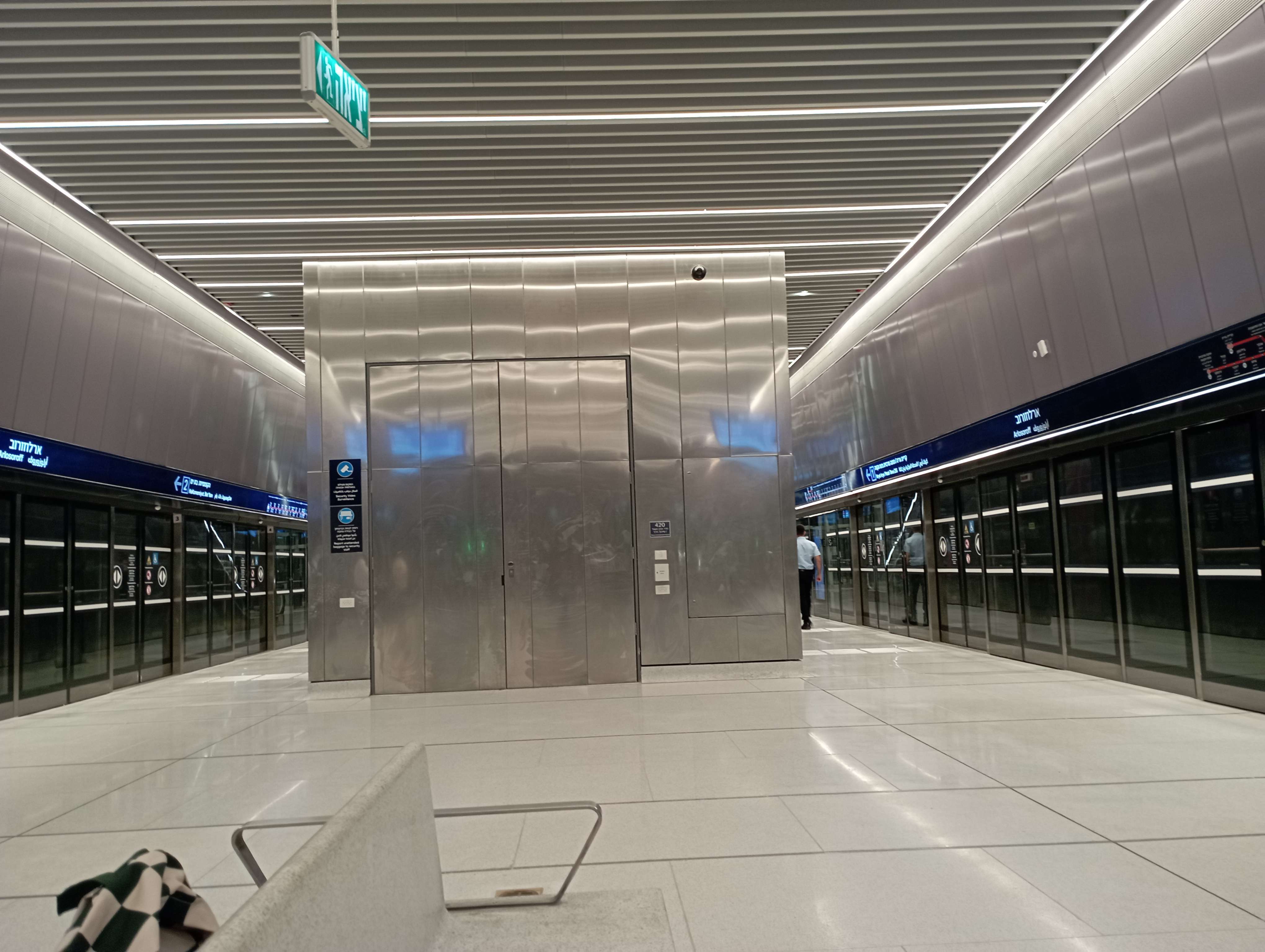
Israel Railways does have security theater – one has to open one’s bags in front of a security guard and go through a metal detector, and this being Israel, there is extensive racial profililng. But the light rail, including the underground portions in Tel Aviv, do not. There’s a lot of visible security presence, including cameras, security personnel, and K-9 units, but no metal detectors. This is in a country that, in the 1990s and early 2000s, underwent a wave of suicide bombings on buses, and still didn’t put metal detectors on them, because it’s infeasible to install such technology on surface transit, and too expensive and frankly not too useful on metros (a security line is an attractive bombing target).
This shouldn’t be too surprising, in a way. Western Europe did not install security theater on trains in response to far-left terrorism in the 1970s and 80s. Israel’s way of building and running public transportation is intended as a pan-European medley, using consultants who have done work in Europe, and with media discourse that looks up to Europe’s urban transportation systems (on other matters Israel looks up to the United States, but Israelis understand American public transportation is not good). If nobody in Europe (or at least Western Europe) does something, it’s unlikely Israel will do it, not on civilian public infrastructure.
Small Metros Aren’t Lean, They’re Underbuilt
Reece Martin does very good vlogs on public transportation, and has begun text-blogging more regularly, which I appreciate greatly. But a post of his from six days ago, talking about lean metros, misses a key aspect of short metro systems. He compares old legacy systems like Paris or New York or Berlin’s with newer ones, like Hong Kong’s, and points out that the newer ones are rather short relative to city size, saying that it’s a leaner, lower-cost way of doing things. But in fact, the reason we see such short metros relative to city size is not efficiency, but underbuilding, leading to overcrowding.
What’s a lean metro?
Reece divides leanness into two kinds. The first is the ability of some cities to build driverless metros with very short trains at very high frequencies, to save money on station construction. He gives the examples of Copenhagen and Vancouver. This is particularly common in Italy: Milan Metro Lines 4 and 5 have 50 meter long trains, the Turin Metro has 55 meter long trains, the Brescia Metro has 40 meter long trains. With this setup and with the generally low construction costs of Italy, even Brescia can afford a metro, in a city proper of 200,000 with a built-up urban area of 673,000 (and rising) as of 2011.
The second kind of leanness is just building fewer lines. He talks about Toronto’s system, with two main trunk lines, one branch line with a transfer to a main line, and a total of 70 km of length. He also brings up Hong Kong, which has, counting both proper metro lines and the two inherited commuter lines, around 212 route-km, with very high ridership. This can be supported through transit-oriented development, for which Hong Kong is famous. It can also come from strong bus-rail connections as in Toronto: a blog post from last decade that I can no longer find points out that York Mills has what looks like 14,000 weekday boardings on pre-corona numbers, despite low-density land use immediately surrounding it, because of the strong connecting buses on the Toronto grid, favorably comparing it with American metros like Washington’s.
Small station metros
I don’t want to criticize the Italian trend too much, but I do want to separate it from the other systems Reece calls lean. The issue with the style of construction used in Brescia is that it’s really good, if your city is the size of Brescia. Small-station, partly cut-and-cover driverless metros should be in the toolkit of metro areas of about a million people, in order to save money. Other tools should be heavily relying on legacy commuter lines (as in Zurich) and using trams if they’re available (as in Bratislava or Brno), and likely combining all three solutions when feasible (in fact Zurich has a large tramway network in addition to the S-Bahn).
In a larger city, such light metro lines are only useful in a very restricted set of circumstances. Singapore has short trains on the Circle Line – but the Circle Line has not been cheap to build, and its last section has been extraordinarily expensive. On a radial line, it’s a nonstarter. A large city needs the very high throughput of a driverless metro but also larger trains; those can be medium-length trains, like the 90 meter trains of Paris Métro Line 1, or longer, like the 138 meter long trains of the now-driverless legacy lines in Singapore, or the 200 meter long platforms of the Shinbundang Line in Seoul. If the line is too short, the city may find it needs to build another just for relief, as the area that was once thought peripheral develops.
Short metros
If a metro system is short, even if its trains are long, it’s not generally a sign of efficient construction in the city. It’s a sign of underbuilding and overcrowding.
Hong Kong has very high crowding levels, even with a system length that, counted properly, is not that unreasonable: the MTR’s total route-length is almost the same as that of the Paris Métro, which has 227 km, and its ridership is, on pre-corona numbers, slightly higher, 1.7 billion a year compared with 1.5 billion. Now, to be clear, Paris has very high ridership for the system’s size. I suspect the reason I’ve never seen overcrowding on the Métro is that the nature of Parisian job concentration is such that the lines that get overcrowded are ones connecting the suburbs with the city, that is, the RER and M13, rather than predominantly intra-city lines like M1. But the situation in Hong Kong is overall less one of leanness and more one of not being to expand as fast as it would like due to extreme construction costs, which are a strong contender for the world’s second worst, after New York’s. (Toronto is an even stronger contender.)
Then there are the developing-world metros that are just far too short for their city size. Hong Kong is a city of 7 million with a little more than 200 km of metro and commuter rail. Cairo is a metro area of 22 million with 100 km of metro. Cairene construction costs are high, but when, depending on how much one trusts dead links from 10 years ago, the city has the world’s highest rail ridership per km, it needs a lot more; that Cairo has 100 km of metro rather than 800 like Shanghai, a similar-size city in a country that, during its peak expansion, was about as rich as Egypt, is not about leanness but about the Egyptian government’s spending priorities.
For a middle-income country that wants to get out of the middle-income trap that Egypt is stuck in (or Brazil, home to the almost as underbuilt São Paulo Metro), China is a decent benchmark. So is Paris – France is rich but also, precisely because it’s rich, rather motorized by any developing country standards, leading to a modal split of about 43% public transit, 43% cars for work trips in Ile-de-France. Using these benchmarks, your city should have on the order of 30 km of metro and new commuter rail per million residents. If you have 4.5 like Cairo, it’s not efficiency, it’s total disinterest in the living standards of the urban population.
The MTA Sticks to Its Oversize Stations
In our construction costs report, we highlighted the vast size of the station digs for Second Avenue Subway Phase 1 as one of the primary reasons for the project’s extreme costs. The project’s three new stations cost about three times as much as they should have, even keeping all other issues equal: 96th Street’s dig is about three times as long as necessary based on the trains’ length, and 72nd and 86th Street’s are about twice as long but the stations were mined rather than built cut-and-cover, raising their costs to match that of 96th each. In most comparable cases we’ve found, including Paris, Istanbul, Rome, Stockholm, and (to some extent) Berlin, station digs are barely longer than the minimum necessary for the train platform.
MTA Construction and Development has chosen to keep building oversize stations for Second Avenue Subway Phase 2, a project that despite being for the most part easier than the already-open Phase 1, is projected to cost slightly more per kilometer. Nolan Hicks at the New York Post just published a profile diagram:

The enormous size of 125th Street Station is not going to be a grand civic space. As the diagram indicates, the length of the dig past the platforms will not be accessible to passengers. Instead, it will be used for staff and mechanical rooms. Each department wants its own dedicated space, and at no point has MTA leadership told them no.
Worse, this is the station that has to be mined, since it goes under the Lexington Avenue Line. A high-cost construction technique here is unavoidable, which means that the value of avoiding extra costs is higher than at a shallow cut-and-cover dig like those of 106th and 116th Streets. Hence, the $1 billion hard cost of a single station. This is an understandable cost for a commuter rail station mined under a city center, with four tracks and long trains; on a subway, even one with trains the length of those of the New York City Subway, it is not excusable.
When we researched the case report on Phase 1, one of the things we were told is that the reason for the large size of the stations is that within the MTA, New York City Transit is the prestige agency and gets to call the shots; Capital Construction, now Construction and Development, is smaller and lacks the power to tell NYCT no, and from NYCT’s perspective, giving each department its own break rooms is free money from outside. One of the potential solutions we considered was changing the organizational chart of the agency so that C&D would be grouped with general public works and infrastructure agencies and not with NYCT.
But now the head of the MTA is Janno Lieber, who came from C&D. He knows about our report. So does C&D head Jamie Torres-Springer. When one of Torres-Springer’s staffers said a year ago that of course Second Avenue Subway needs more circulation space than Citybanan in Stockholm, since it has higher ridership (in fact, in 2019 the ridership at each of the two Citybana stations, e.g. pp. 39 and 41, was higher than at each of the three Second Avenue Subway stations), the Stockholm reference wasn’t random. They no longer make that false claim. But they stick to the conclusion that is based on this and similar false claims – namely, that it’s normal to build underground urban rail stations with digs that are twice as long as the platform.
When I call for removing Lieber and Torres-Springer from their positions, publicly, and without a soft landing, this is what I mean. They waste money, and so far, they’ve been rewarded: Phase 2 has received a Full Funding Grant Agreement (FFGA) from the United States Department of Transportation, giving federal imprimatur to the transparently overly expensive design. When they retire, their successors will get to see that incompetence and multi-billion dollar waste is rewarded, and will aim to imitate that. If, in contrast, the governor does the right thing and replaces Lieber and Torres-Springer with people who are not incurious hacks – people who don’t come from the usual milieu of political appointments in the United States but have a track record of success (which, in construction, means not hiring someone from an English-speaking country) – then the message will be the exact opposite: do a good job or else.
Urbanism for non-Tourists
There’s a common line among urbanists and advocates of car-free cities to the effect that all the nice places people go to for tourism are car-light, so why not have that at home? It’s usually phrased as “cities that people love” (for example, in Brent Toderian), but to that effect, mainly North American (or Australian) urbanists talk about how European cities are walkable, often in places where car use is rather high and it’s just the tourist ghetto that is walkable. Conversely, some of the most transit-oriented and dynamic cities in the developed world lack these features, or have them in rather unimportant places.
Normally, “Americans are wrong about Europe” is not that important in the grand scheme of things. The reason American cities with a handful of exceptions don’t have public transit isn’t that urbanist advocacy worries too much about pedestrianizing city center streets and too little about building subways to the rest of the city. Rather, the problem is the effect of tourism- and consumption-theoretic urbanism right here. It, of course, doesn’t come back from the United States – European urbanists don’t really follow American developments, which I’m reminded of every time a German activist on Mastodon or Reddit tries explaining metro construction costs to me. It’s an internal development, just one that is so parallel to how Americans analytically get Europe wrong that it’s worth discussing this in tandem.
The core of public transit
I wrote a blog post many years ago about what I called the in-between neighborhoods, and another after that. The two posts are rather Providence-centric – I lived there when I wrote the first post, in 2012 – but they describe something more general. The workhorses of public transit in healthy systems like New York’s or Berlin’s or Paris’s, or even barely-existing ones like Providence’s, are urban neighborhoods outside city center.
The definitions of both “urban” and “outside city center” are flexible, to be clear. In Providence, I was talking about the neighborhoods on what is now the R bus route, namely South Providence and the areas on North Main Street, plus some similar neighborhoods, including the East Side (the university neighborhood, the only one in Providence’s core that’s not poor) and Olneyville in the west. In larger, denser, more transit-oriented Berlin, those neighborhoods comprise the Wilhelmine Ring and thence stretch out well past the Ringbahn, sometimes even to city limits in those sectors where sufficient transit-oriented development has been built, and a single district like Neukölln may have more people than the entirety of Providence.
In Berlin, this can be seen in modal splits by borough; scroll down to the tables by borough, and go to page 45 of each PDF. The modal split does not at all peak in the center. Among the 12 boroughs, the one with the highest transit modal split for work trips is actually Marzahn-Hellersdorf, in deep East Berlin. The lowest car modal split is in the two centermost boroughs, Mitte and Kreuzberg-Friedrichshain, both with near-majorities for pedestrian and bike commutes – but the range of both of these modes is limited enough that it’s not supportable anywhere else in Berlin.
Nor is shrinking the city to the range of a bike going to help. Germany is full of cities of similar size to the combined total of Mitte and Kreuzberg-Friedrichshain; they have much higher car use, because what makes the center of Berlin work is the large concentration of jobs and other destinations brought about by the size of the city.
The same picture emerges in other transit cities. In Paris, the city itself is significant for the region’s public transit network, but its residents only comprise 30% of Francilien transit commuters, and even that figure should probably subtract out the outer areas of the city, which tourists don’t go to, like the entire northeast or the areas around and past the Boulevards of the Marshals. The city itself has much higher modal split than its suburbs, but that, again, depends on a thick network of jobs and other destinations that exist because of the dominance of the city as a commercial destination within a larger region.
Where tourists go
The in-between neighborhoods that drive the transit-oriented character of major cities are generally residential, or maybe mixed-use. Usually, they do not have tourist destinations. In Berlin, I advocate for tourists to visit Gropiusstadt and see its urbanism, but I get that people only do it if they’re especially interested in urban exploration. Instead, tourism clusters in city center; the museums are almost always in the center to the point that exceptions (like Balboa Park in San Diego) are notable, high-end hotels cluster in city center (the Los Angeles exception is again notable), and so on.
These tourism-oriented city centers often include pedestrianized street stretches. Berlin is rather atypical in Germany in not having such a stretch; in contrast, tourists can lose themselves in Marienplatz in Munich, or in various Altstadt areas of other cities, and forget that these cities have higher car use than Berlin, often much higher. For example, Leipzig’s car modal split for work trips is 47% (source, p. 13), higher than even Berlin’s highest-modal split borough, Spandau, which has 44% (Berlin overall is at 25%).
To be clear, Leipzig is, by most standards, fairly transit-oriented. Its tram network has healthy ridership, and its S-Bahn tunnel is a decent if imperfect compromise between the need to provide metro-like train service through the city and the need to provide long-distance regional rail to Halle and other independent cities in the region. But it should be more like Berlin and not the reverse.
Another feature of tourist cities is the premodern city core, with its charming very narrow streets. Berlin lacks such a core, and Paris only has a handful of such streets, mostly in the Latin Quarter. But Stockholm has an intact Early Modern core in Gamla Stan; it is for all intents and purposes a tourist ghetto, featuring retail catering to tourists and not much else. Stockholm is a very strong transit city with a monocentric core, but the core is not even at Gamla Stan, but to its north, north of T-Centralen, and thus the other tourist feature, the pedestrianized city center street with high-end retail, remains distinct from the premodern core.
Tellingly, these premodern cores exist even in thoroughly auto-oriented cities, ones with much weaker public transit than Leipzig. Italy supplies many examples of cities that were famously large in the Renaissance, and still have intact cores where one can visit the museums. A few years ago, Marco Chitti pointed out how Italian politicians, like foreign tourists, like taking photo-ops at farmers’ markets in small historic cities, while meanwhile, everyone in Italy does their shopping at suburban shopping centers offering far lower prices. To the tourist, Florence looks charming; to the resident, it is, in practice, a far more auto-oriented region than Stockholm or Berlin.
The Regional Connector and Network Coherence
The Regional Connector just opened in Los Angeles. This is a short, expensive tunnel permitting through-running for the city’s main light rail lines, linking the A Line (formerly Blue) with the half of L (formerly Gold) to Pasadena and Azusa and the E (formerly Expo) with the half of the L to East Los Angeles. It’s a welcome development and I only regret that this line cost, in 2022 dollars, $660 million per km. The broader question about the line, though, is that of line pairing and network coherence.

Network coherence is a nebulous concept. I can best define it as “it looks reasonable on a map,” but then the number of railfan crayons that violate coherence principles is so large that it has to be defined more precisely. Usually I talk about it in two concrete ways: a rapid transit network should avoid reverse-branching and tangential lines.
But there are some more concerns, which are less obvious than those two, and also appropriate to violate in some cases. My previous post on New York alludes to the principle of consistency of local and express trains, which is good to aspire to but may conflict with other priorities. In fact, the current pattern in Los Angeles is coherent: trains go north-south on the new A Line or east-west on the new E Line; the question, posed to me by a supporter (thank you!), is whether it should be. I think this is right, but it’s not obvious (in fact it wasn’t to the reader who posed this question).
The issue is that simple coherence – lines from the south should go north and not east, express trains on one side should go through city center and then be express on the other side, and so on – is a good starting point. But there may be other concerns at play. When SEPTA opened the Center City Commuter Connection in the 1980s, it relabeled its commuter rail lines R1 through R8, skipping R4, pairing each branch on the former Pennsylvania Railroad side with one on the Reading side; the resulting map, for which this was an early plan, was not at all coherent and featured self-intersecting lines, but it matched the lines based on expected ridership and railyard locations.
The New York City Subway, likewise, has some pairings that only make sense in light of railyards. The R train shares local tracks in Manhattan with the W train, but in Queens it goes to the Queens Boulevard Line whereas the N shares tracks with the W to Astoria, because the Queens Boulevard Line has a yard at the end and the Astoria Line does not, and the N has a yard at the Brooklyn end of Coney Island whereas the R does not at Bay Ridge; the R is the longest all-local line in the system and railfans periodically propose to switch it with the N in Queens, but the railyard issue makes it problematic in the current situation.
Matching branches by ridership, though, runs into the problem of inconsistent headways on the trunk. A light rail line running every eight minutes can share a tunnel with another light rail line running every eight, but if one of them runs every six minutes, they will run into each other on the shared section. This problem is magnified if both the shared section and the branches are long, which is usually the case in New York; thankfully, in Los Angeles the shared section is short enough that optimizing on it is less important. At most, it’s possibly to match branches by ridership if the train lengths can be made different.
The final concern that may lead to violations of coherence is origin-and-destination ridership patterns; I think this is what my reader had in mind when querying it. Such patterns may be ethnic – there’s a notable bump in ridership between Anacostia and Columbia Heights on the Washington Metro, and it’s likely that such patterns also exist elsewhere in cities that just don’t track O&D pairings, like New York with its internal Chinatown buses. They may even be classed, in the sense that wealthier Americans are likelier to be working in city center, but on the whole, rich and poor people are mostly traveling to the same places. They may be sporadic – a university may be driving ridership enough that there could be connections to either places students want to go or (for commuter universities like UBC) where students live.
O&D pairings like this should, as a rule, never drive infrastructure decisions. These patterns are too fleeting – for example, Columbia Heights’ gentrification is so rapid that the links with Anacostia are unlikely to last for more than a generation. However, it’s not always bad to look at them when making decisions on service for a given infrastructure network.
The issue, though, is that there’s no real compulsion to connect Long Beach with East Los Angeles or Santa Monica with Pasadena and Azusa. The commute data doesn’t suggest special links (which, to be fair, it also doesn’t in Washington). I am not aware of any other big pattern that would create such ridership. So it’s something that I think Metro should have looked at (and probably did), but ultimately made the right decision on.


