Category: Urban Transit
Quick Note on My New York Trip
I am back in Europe now (in London until Tuesday), but I was in New York for nearly three weeks, and it was interesting reconciling what I was seeing with what everyone else is saying about the city. It and my March 2022 trip were both enlightening in a way because I’d last been in the US at the end of 2019, so many New Yorkisms that I was used to in the 2000s and 2010s suddenly jarred me as foreign to what I had grown used to in Europe.
As one might expect based on the subject of this blog, I took the subway a lot. I took it so much that I was using weekly passes, and the last week I had a weekly pass for just three days and still I took 13 trips on those days, justifying its cost (which is like that of 12 single trips). I saw things, and notably didn’t see others.
What I did see: abject unreliability. I snapped a photo whenever the train arrival board was showing something weird, like low frequency or bunching; if you’re reading this post as it’s being posted and not going on a deep archive run, then go to my Twitter media and look at the last few weeks of pictures. Out of 19 days, something was going wrong 10 times, usually on the train I used to get between my Queensbridge hotel and Marron, the F train – and that’s without counting a few trips when the train frequency looked good but then I was delayed 10-20 minutes due to incidents. Something would always come up: signal failure, medical emergency, mechanical failure, cascading delays. Uday Schultz, a railfan who scares me with the depth of his knowledge of operations, maintenance, and rail history, points out how one such delay compounded due to bad interlining.
This is not normal. Berlin has delays but nowhere nearly this often – not on the U-Bahn but also not on the S-Bahn, whose interlining complexity is comparable to that of the New York City Subway. Low-frequency sections due to single-tracking for maintenance exist in Berlin, but it’s rare, and trains do not run worse than every 10 minutes except on the suburban periphery of the city. Over a similar period of time in Berlin I might see an incident bad enough to complain to BVG about it on Twitter maybe once or twice, not 10 times.
What I didn’t see: significant crime. I point out that I was staying near Queensbridge because the area is negatively stereotyped by suburbanites and city residents with I-hate-(the-rest-of-)the-city identity politics. Nothing there looked scary, at any time of day. There’s a large housing project there, which I mostly associate with people playing the Halloween theme song on 10/31 for what I imagine was a showing of the film and with some people wearing delightfully scary costumes. The worst I saw was someone selling swipes illegally when there was an unusually long line for the ticketing machines; there were cops on the platform who must have passed this person by and apparently done nothing.
I point this out because the city is convinced that the subway is dangerous. There are annoying announcements all the time: “this is an important message from the New York City Police Department…” It makes for some awful user experience – there’s no possibility of quiet on the train, for which those announcements contribute more than anything, since the panhandlers are much less common and the background noise is easier to tune out. People who speak limited English or can’t make out the phonemes garbled over bad announcer systems learn to tune everything out, including the occasional useful announcement of service changes.
And the police loves how annoying it is, which it justifies by appealing to safety theater. When Sarah Meyer tried reducing the annoyance levels, she ran into some real and some made-up technical problems, and one political problem in that nobody in management cares about UX. The police said they need those announcements, annoying and counterproductive as they are (telling tourists to watch their belongings gets them to grasp their wallets in fear, alerting every thief to the location of the wallet on their person); nobody at the agency thought to push back. In the last few days, a new disturbance has been added: the conductors announce at nearly every stop that cops are on the platform should people need assistance. This is in a safe city. Just stop this.
Quick Note on Transit Expansion and Development
I’ve been thinking a lot about where subway extensions can go in New York. One of the appendices we’re likely to include down the line in the Transit Costs Project is a proposal for what New York could do if its construction costs were more reasonable, and this means having to think about plausible extensions. Leaving aside regional rail and systematic investments for now, this may roughly be it:
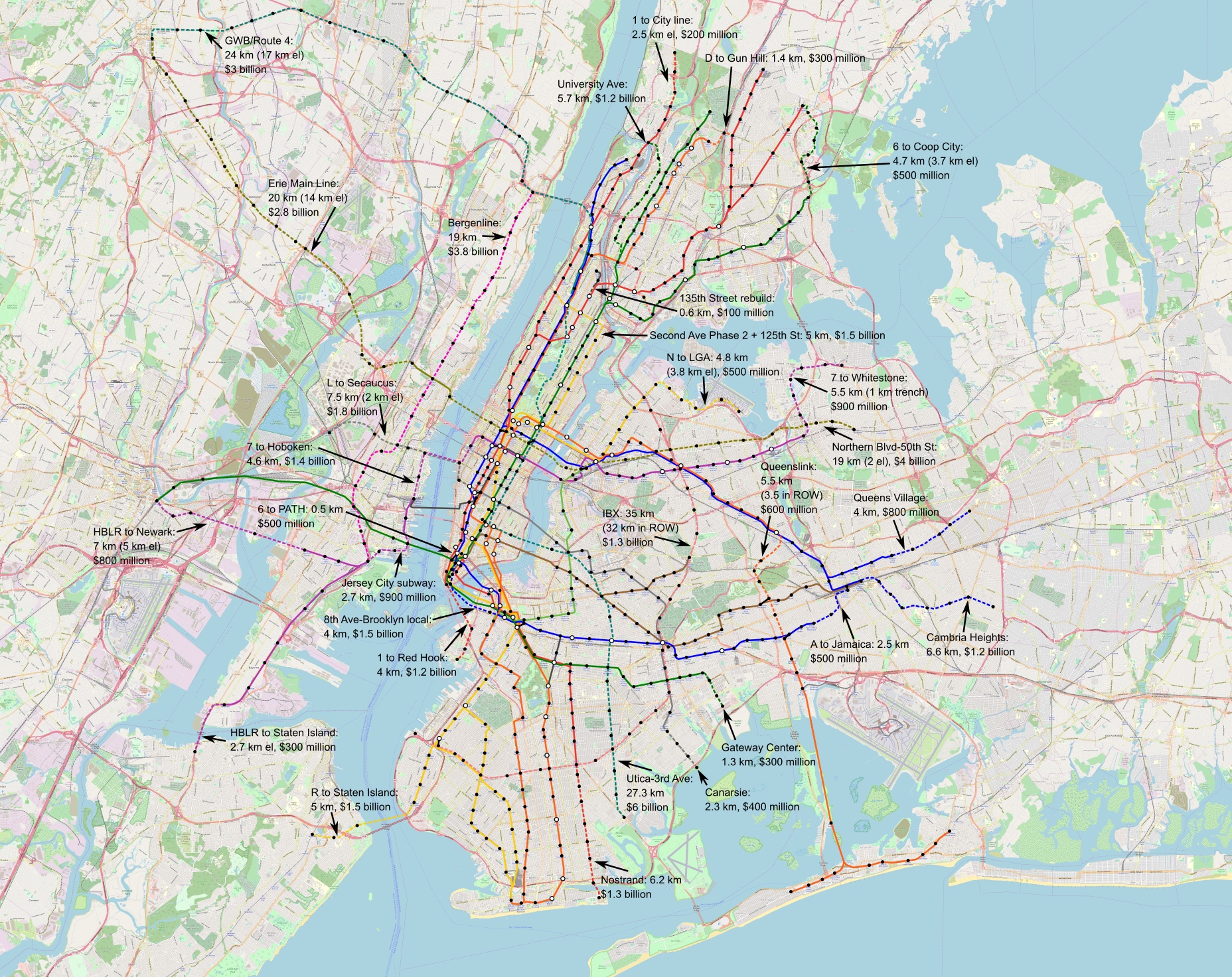
The full-size image (warning: 52 MB) can be found here.
The costs depicted are about twice as high as what I wrote in 2019 with Nordic costs as the baseline, because nominal Nordic costs have doubled since then, partly due to updating price levels from the early 2010s to the early 2020s, but mostly because of the real cost explosion in the Nordic countries. These costs are about $200 million/km in outlying areas, $300 million/km in Manhattan or across water, somewhat less than $100 million/km above ground or in an open trench, and higher than $300 million/km when reconstruction of existing tunnel complexes is proposed; everything is rounded to the nearest $100 million, which creates some rounding artifacts for short extensions that cancel one another out.
But the precise map is not what I think is the most interesting. The point is to build to the frontier of the cost per rider that is acceptable in American cities today, so by definition the marginal line for inclusion on the map, such as the D extension to Gun Hill Road to meet with the 2 train, is also socioeconomically marginal. What I think is more interesting is how important transit-oriented development is for the prospects of lines beyond the most obvious ones (Second Avenue Subway Phase 2, 125th Street, Utica, Nostrand, IBX, and maybe also the 7 to College Point).
The current land use in New York is largely frozen from the middle of the 20th century; the 1961 zoning law was the watershed. Since then, change has been slow, in contrast with rapid redevelopment in places that have chosen a pro-growth path. If the pace of change stays slow, then fewer lines are viable; if the city instead chooses not to keep anti-developmental neighborhood interests in the loop, then more are.
This, in turn, feeds into growth plans. Nordic and Italian planning bundles the question of where the regional housing growth goes with where the subway goes. (Our other positive case study, Turkey, works differently; the answer to both questions is “everywhere.”) This means that subway service goes to areas where substantial quantities of transit-oriented development will be permitted and built, often in negotiations with NIMBY municipalities that would rather just get the infrastructure without the housing; in Stockholm the scale involved is tens of thousands of units per tranche of Nya Tunnelbanan.
In the case of New York, this affects the shape of the map above more than anything. The 6 extension to Coop City is likely good either way, but the other radial extensions in the Bronx are more questionable and depend on where new housing in the borough will be built. The same is true in Queens: more housing in Northeast Queens may argue even in favor of further lines not depicted on the map, for example extending the 7 even further.
One- and Two-Seat Rides
All large urban rail networks rely on transfers – there are too many lines for direct service between any pair of stations. However, transfers are still usually undesirable; there is a transfer penalty, which can be mitigated but not eliminated. This forces the planners who design urban and suburban rail systems to optimize: too many transfers and the trips are too inconvenient, too few and the compromises required to avoid transfers are also too inconvenient. How do they do it? And why?
Of note, the strategies detailed below are valid for both urban rail and suburban commuter rail systems. Multi-line commuter rail networks like the RER and the Berlin S-Bahn tend to resemble urban rail in their core and work in conjunction with the rest of the urban rail network, and therefore strategies for reducing the onerousness of transferring work in much the same way for both kinds of systems. Suburban strategies such as timing half-hourly trains to meet connecting buses are distinct and outside the scope of this post.
Transfer penalties
Passengers universally prefer to avoid transfers between vehicles, keeping everything else constant. The transportation studies literature has enough studies on this pattern that it has a name: transfer penalty. The transfer penalty consists of three elements:
- Walking time between platforms or bus curbs
- Waiting time for the connecting train or bus
- An independent inconvenience factor in addition to the extra time
One meta-study of this topic is by Iseki-Taylor-Miller of the Institute for Transportation Studies. There’s a bewildering array of different assumptions and even in the same city the estimates may differ. The usual way this is planned in elasticity estimates is to bundle the inconvenience factor into walking and waiting times; passengers perceive these to be more onerous than in-vehicle time, by a factor that depends on the study. Iseki-Taylor-Miller quote a factor as low as 1.4-1.7 and Lago-Mayworm-McEnroe’s classic paper, sourced to a Swedish study, go up to 3; Teulings-Ossokina-de Groot suggest it is 2, which is the figure I usually use, because of the convenience of assuming worst-case scenario for waiting time (on average, the wait is half the headway).
The penalty differs based on the quality of station facilities, and Fan-Guthrie-Levinson investigate this for bus shelter. However, urban rail estimates including those in the above meta-studies are less dependent on station facilities, which are good in all cases.
Mitigating the transfer penalty
Reducing the transfer penalty for riders can be done in three ways, if one believes the model with a constant penalty factor (say 2):
- Reducing the number of transfers
- Reducing walking time between platforms
- Reducing waiting time for trains
All three are useful strategies for good urban rail network planning, and yet all three are useful only up to a point, beyond which they create more problems than they solve.
Reducing transfers
The most coherent network planning principle for reducing passengers’ need to transfer is to build radial rail networks. Such networks ideally ensure each pair of lines intersects once in or near city center, with a transfer, and thus there is at most one transfer between any pair of stations. A circumferential line may be added, creating some situations in which a three-legged trip is superior in case it saves a lot of time compared with the two-legged option; in Moscow, the explicit purpose of the Circle Line is to take pressure off the congested passageway of the central transfer connecting the first three lines.
In general, the most coherent radial networks are those inherited from the Soviet tradition of metro building; the London Underground, which influenced this tradition in the 1920s, is fairly radial itself, but has some seams. It’s important in all cases to plan forward and ensure that every pair of lines that meets has a transfer. New York has tens of missed connections on the subway, and Tokyo has many as well, some due to haphazard planning, some due to an explicit desire to build the newer lines as express relief lines to the oversubscribed older lines.
On a regional rail network, the planning is more constrained by the need to build short tunnels connecting existing lines. In that case, it’s best to produce something as close to a coherent radial network with transfers at all junctions as possible. Through-running is valuable here, even if most pairs of origins and destinations on a branched commuter line trunk still require a transfer, for two reasons. First, if there is through-running, then passengers can transfer at multiple points along the line, and not just at the congested city center terminus. And second, while through-running doesn’t always cut the transfer for suburb-to-suburb trips, it does reliably cut the transfer for neighborhood-to-suburb trips involving a connection to the metro: a diameter can be guaranteed to connect with all radial metro lines, whereas a radius (terminating at city center) will necessarily miss some of them, forcing an extra transfer on many riders.
Reducing walking time
The ideal transfer is cross-platform, without any walking time save that necessary to cross a platform no more than 10-15 meters wide. Some metro building traditions aim for this from the outset: London has spent considerable effort on ensuring the key Victoria line transfers are cross-platform and this has influenced Singapore and Hong Kong, and Berlin has accreted several such transfers, including between the U- and S-Bahn at Wuhletal.
However, this is not always viable. The place where transfers are most valuable – city center – is also where construction is the most constrained. If two lines running under wide streets cross, it’s usually too costly to tilt them in such a way that the platforms are parallel and a cross-platform transfer is possible. But even in that case, it’s best to make the passageways between the platforms as short as possible. A cruciform configuration with stairs and an elevator in the middle is the optimum; the labyrinthine passageways of Parisian Métro stations are to be avoided.
Reducing waiting time
The simplest way to reduce waiting time is to run frequently. Passengers’ willingness to make untimed transfers is the highest when frequency is the highest, because the 2-minute wait found on such systems barely lengthens one’s trip even in the worst case, when one has frustratingly just missed the train.
Radial metro networks based on two- rather than one-seat rides pair well with high frequency. Blog supporter and frequent commenter Threestationsquare went viral last month when he visited Kyiv, a Soviet-style three-line radial system, and noted that due to wartime cuts the trains only run every 6-7 minutes off-peak; Americans amplified this and laughed at the idea that base frequency could be so high that a train every 7 minutes takes the appellation “only.”
When frequency is lower, for example on a branch or at night, cross-platform transfers can be timed, as is the case in Berlin. But these are usually accidental transfers, since the core city center transfers are on frequent trunks, and thus the system is only valuable at night. Moreover, timed transfers almost never work outside cross-platform transfers, which as noted above are not always possible; the only example I’m aware of is in Vienna, where a four-way transfer with stacked parallel platforms is timed.
This is naturally harder on a branched commuter rail system. In that case, it’s possible to set up the timetable to make the likeliest origin-destination pairs have short transfer windows, or even one-seat rides. However, in general transfers may require a wait as long as the system’s base clockface intervals, which is unlikely to be better than 20 minutes except on the busiest trunks in the largest cities; even Paris mixes 10-, 15-, and occasionally 20- and 30-minute intervals on RER branches.
Subway Expansion to Kingsborough Community College
One of the perennial wishlist items for New York subway expansion is Nostrand Avenue. The 2 and 5 trains run under the avenue between Eastern Parkway and Brooklyn College, a distance of 4 km; from the start, the line was intended to be extended farther south, and in both the 1950s and 1970, there were plans for such extension as well as one shortly to the east under Utica, to be built right after Second Avenue Subway. The case for Nostrand and Utica remains strong – these two streets host Brooklyn’s two busiest buses (the B44 and B46 respectively), and another top route, the B41 on Flatbush, is closely parallel. The purpose of this post is to ask what the southern end of Nostrand should be, and whether a longer extension going to Kingsborough Community College is a good idea.
Nostrand: current plans
All plans I am aware of for extending the subway under Nostrand have it following the street to Sheepshead Bay. For example, my proposal from 2019 would terminate it right at the water, at Emmons Avenue, where the B44’s southern end is. This reflects official proposals over the last few generations: a Nostrand subway is to run just under Nostrand.
Kingsborough Community College
Right across geographic Sheepshead Bay from the neighborhood named after the bay, the eastern end of geographic Coney Island comprises the neighborhood of Manhattan Beach. It is not a dense area, and for the use of residents, there are buses to the Brighton Beach subway station. However, at the easternmost end of Manhattan Beach, Kingsborough Community College (KBCC) is a huge destination.
How huge? The bus serving it, the B1, is one of the busiest in Brooklyn, with some rush hour runs just operating back and forth as short-hop shuttles between Brighton Beach and KBCC, a distance of 2 km. Frequency at rush hour reached a bus every 3-4 minutes before corona.
This is not easily legible to commuter-oriented planning tools like OnTheMap. That area has only 1,000 jobs; KBCC itself doesn’t generate many jobs, nor does it anchor other industries around it that aim to employ graduates. Those planning tools can capture other universities if they’re more residential and higher-end – those have a higher ratio of faculty to students, have ample research labs, and anchor employers who look to locate near residential students. In contrast, a commuter college is largely invisible to them. In reality, there are 18,000 students, all of whom commute from elsewhere.
How much ridership does this generate?
KBCC has 18,000 students, and the overall area has 1,000 workers. If the modal split were 100%, this should generate 38,000 trips per weekday; commuter colleges don’t generate as many non-commute trips as do residential colleges. In reality, the modal split is not 100%, but it should be high given the low car ownership rates in the city, especially low for college students.
The bigger question is what proportion of the travel market would ride a Nostrand subway in preference to a rail-bus connection at Brighton Beach. This in turn depends on the state of the rest of the system. If the Interborough Express or some variant of it is already built, then from all points on or north of the IBX route, an all-rail route is superior to a rail-bus connection. If it isn’t, then it’s dicier, and from much of Southern Brooklyn from the Brighton Line to the west, the B1 is likely faster.
IBX should be built ahead of such a connection based on current plans, so the assumption should be the more optimistic one – and, of course, if there is long-term planning for subway extensions, then this should figure as an argument in favor of IBX. KBCC is hardly the only place that, despite being far from IBX, IBX can help riders access. In that scenario, 30,000 trips a day are not unrealistic, and 20,000 should be conservative.
How much should this cost?
I do not know. In an unusual inversion, I’m more confident of the benefits than the costs. The travel market is fairly circumscribed. In contrast, the costs have a question mark, because of the premium coming from underwater construction.
With no premium at all, New York should be able to reduce its construction costs for subways to $200 million per km on average, and less on easy sections, that is, on outer extensions of the system in the Outer Boroughs. But Nostrand has a high water table, and the underwater segment across Sheepshead Bay is not easy; figure $250-300 million per km, with a wide error margin.
This is not an onerous cost. It’s about 600-700 meters longer than the usual plan for Nostrand to Emmons, and presumably the whole route would be built at once with a tunnel boring machine, so the fixed costs are already paid. So $200 million is probably a reasonable cost.
IBX Cannot be a Tram
Clay Guse of the NY Daily News reports that in New York, the plans for the Interborough Express connector between Brooklyn and Queens are starting to lean in the direction of light rail. To be very clear, light rail in this context just means running light rail vehicles on infrastructure that is entirely grade-separated, either in the Bay Ridge Branch right-of-way (which has a handful of freight trains and is mostly wide enough for light rail and freight on separate tracks) or on viaducts (over the sections of the branch that are too narrow). I do not think there is any plan to downgrade IBX to a tramway. However, on Twitter I was asked about this anyway: why not make it a tramway, for more on-street flexibility?
What is a tram? Or a streetcar? Or light rail?
A tram or streetcar is a rail vehicle that runs predominantly on-street. The quality of the right-of-way may vary, from full mixed traffic as was traditional, to dedicated lanes that may be shared with buses and emergency traffic, to a grassy median that is no longer usable by road vehicles. But the distinguishing feature of the streetcar is that it runs on a street.
The doesn’t mean the streetcar has to run on-street the entire way. Street running is slow, even with dedicated lanes. Paris’s T3, an orbital tram in the grassy median of the Boulevards des Maréchaux on the outer margin of the city, averages 18 km/h. Berlin’s streetcars average 19 km/h; a handful of central sections are mixed-traffic but most have dedicated lanes, and in outer parts of the city there’s just less traffic and lines are generally faster.
There are two main ways to speed up the streetcar: make it faster in city center via tunneling (called subway-surface, Stadtbahn, or premetro), or make it faster outside city center by finding grade-separated rights-of-way (called tram-trains). Confusing, both subway-surface and tram-train systems are called light rail in the US, and Germany’s most celebrated tram-train, that of Karlsruhe, is also called Stadtbahn. Because these systems have evolved from all-surface streetcars, the separation between them and streetcars is not always perfect, which is why the American distinction between light rail (either subway-surface or tram-train) and streetcar (all on-street) is sometimes muddied in popular reporting.
Can IBX function as a tram variant?
No.
The problem with running an orbital tram parallel to the right-of-way is that there is no good street for it to run on. On the map below, the thick black line denotes the right-of-way that IBX is to use:
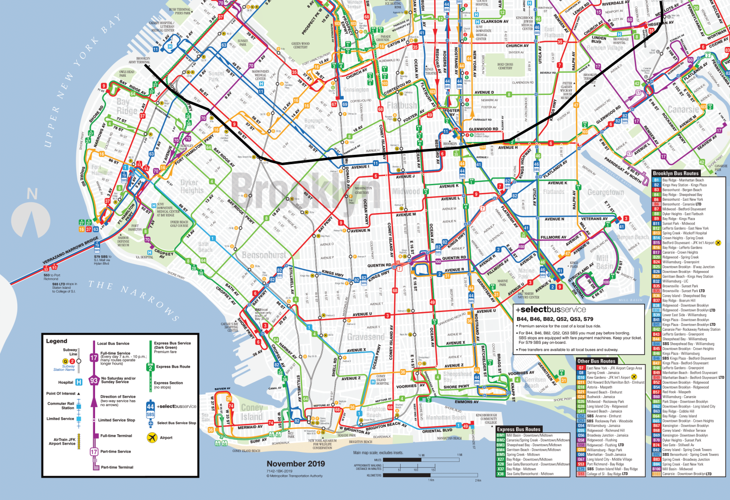
There are no on-street alternatives to the right-of-way. Brooklyn has three major orbital buses: the B35 on Church, and the B6 and B82. Church is not wide – dedicated lanes there would be contentious and still produce inferior speeds to those of T3, let alone streetcars in less dense cities; it’s a great corridor for dedicated bus lanes, but not for a tram. The B6 and B82 shift between different streets, as do other crosstown routes, like the B1, B3, B8, B9, and B11. Even Kings Highway is only 24 meters wide.
This, in turn, is why IBX is such a great idea: it provides service that the surface bus networks can’t provide, because the quality of rights-of-way is poor unless one uses the Bay Ridge Branch. When the street network is poor, surface transit ridership is suppressed relative to travel demand, which means that a rapid transit service like IBX will overperform any model trained on existing travel volumes.
This is also why no variant with any street running is viable. Not only is there no good street for a streetcar, but also there is no section of a street that is good for a streetcar. The narrow sections of the Bay Ridge Branch right-of-way, mainly the segment between the F and Q trains, don’t parallel any convenient street.
Moreover, subway-surface alignments work by branching the grade-separated core into many surface branches, but there is no good tie-in. Circumferential lines sometimes do branch, but the best use case is when there are major destinations just off the route. This is not the case for IBX: Brooklyn College is on-route. The most significant destination in Brooklyn off the route is Kings County Hospital/SUNY Downstate, which is unusually poorly-served by the street network even by Brooklyn standards, and is therefore only on one bus route, the B12, rather than at the intersection of multiple buses as it ideally should be. There is no viable surface deviation off of the IBX right-of-way that serves it.
So why light rail?
The modal alternatives analysis seems biased in favor of light rail. This, to be clear, is not light rail as a service or infrastructure technology – the plan is to use viaducts wherever the Bay Ridge Branch right-of-way is too narrow for IBX and freight tracks side by side. Rather, the plan is to use light rail vehicles on a service that is entirely rapid transit.
This has precedent in the United States. In the same manner that historic streetcars evolved into subway-surface lines in Boston, Philadelphia, and San Francisco, and into the tram-trains that are called light rail elsewhere (with inspiration from Germany, brought in by American troops serving there in the Cold War), some light rail lines evolve into fully grade-separated rapid transit. It’s uncommon, because usually the parts that are left on the surface are the most difficult to construct, but it does exist. The Green Line in Los Angeles runs LRVs on a fully grade-separated right-of-way, mostly in the median of the 105, and the Gold Line’s initial section to and beyond Pasadena has just 1.5 km of street running, on Marmion Way. In Calgary and Dallas there are plans to bury light rail lines, which could result in fully grade-separated lines that still run LRVs and are locally conceived of as light rail.
But in New York, this is not a wise course of action. Running rapid transit with LRVs is great for a city that has LRVs but not subway trains, like the Los Angeles of the early 1990s. A city with both may potentially still elect to use LRVs if it expects some surface extensions. But New York has large-scale operations and maintenance for subway rolling stock, and none for LRVs. The only light rail in the region is in Jersey City and Newark, which do not share management or maintenance facilities with the city, and couldn’t do the latter even if they wanted to since they’re on the wrong side of the Hudson.
If intermediate-capacity transit is desired, New York could build shorter platforms, only long enough for 4- or 5-car trains. If even less capacity is desired, it could go down to 2-car platforms; the rolling stock would need to be somewhat captive to the line, since the rest of the system runs permanently coupled 4- and 5-car trains, but that’s completely normal for a large subway system, and heavy maintenance facilities can still be shared. I’m wary of reductions in capacity just for the sake of downsizing – this is an entirely above-ground project, so station costs are not as onerous as they are underground – but I can see a case for smaller trains.
I can’t find a good reason for this preference for light rail over subway equipment for what is, by infrastructure and service, rapid transit. I can find many bad ones, of which the most likely is a desire for something different from the subway with all the connotations it has.
But this does not mean that the IBX plan is a tram. It’s not; it’s rapid transit service, which could easily be a normal subway, running LRVs for bad reasons.
Deinterlining and Schedule Robustness
There’s an excellent Uday Schultz blog post (but I repeat myself) about subway scheduling in New York. He details some stunning incompetence, coming from the process used to schedule special service during maintenance (at this point, covering the entirety of the weekend period but also some of the weekday off-peak). Some of the schedules are physically impossible – trains are scheduled to overtake other trains on the same track, and at one point four trains are timetabled on the same track. Uday blames this on a combination of outdated software, low maintenance productivity, aggressive slowdowns near work zones, and an understaffed planning department.
Of these, the most important issue is maintenance productivity. Uday’s written about this issue in the past and it’s a big topic, of similar magnitude to the Transit Costs Project’s comparison of expansion costs. But for a fixed level of maintenance productivity, there are still going to be diversions, called general orders or GOs in New York, and operations planning needs to schedule for them. How can this be done better?
The issue of office productivity
Uday lists problems that are specific to scheduling, such as outdated software. But the software is being updated, it just happens to be near the end of the cycle for the current version.
More ominous is the shrinking size of ops planning: in 2016 it had a paper size of 400 with 377 positions actually filled, and by 2021 this fell to 350 paper positions and 284 actually filled ones. Hiring in the American public sector has always been a challenge, and all of the following problems have hit it hard:
- HR moves extraordinarily slowly, measured in months, sometimes years.
- Politicians and their appointees, under pressure to reduce the budget, do so stupidly, imposing blanket hiring freezes even if some departments are understaffed; those politicians universally lack the competence to know which positions are truly necessary and where three people do the job of one.
- The above two issues interact to produce soft hiring freezes: there’s no hiring freeze announced, but management drags the process in order to discourage people from applying.
- Pay is uncompetitive whenever unemployment is low – the compensation per employee is not too far from private-sector norms, but much of it is locked in pensions that vest after 25 years, which is not the time horizon most new hires think in.
- The combination of all the above encourages a time clock managerial culture in which people do not try to rock the boat (because then they will be noticed and may be fired – lifetime employment is an informal and not a formal promise) and advancement is slow, and this too deters junior applicants with ambition.
Scheduling productivity is low, but going from 377 to 284 people in ops planning has not come from productivity enhancements that made 93 workers redundant. To the contrary, as Uday explains, the workload has increased, because the maintenance slowdowns have hit a tipping point in which it’s no longer enough to schedule express trains on local train time; with further slowdowns, trains miss their slots at key merge points with other lines, and this creates cascading delays.
Deinterlining and schedule complexity
One of the benefits of deinterlining is that it reduces the workload for ops planning. There are others, all pertaining to the schedule, such as reliability and capacity, but in this context, what matters is that it’s easier to plan. If there’s a GO slowing down the F train, the current system has to consider how the F interacts with every other lettered route except the L, but a deinterlined system would only have to consider the F and trains on the same trunk.
This in turn has implications for how to do deinterlining. The most urgent deinterlining in New York is at DeKalb Avenue in Brooklyn, where to the north the B and D share two tracks (to Sixth Avenue) and the N and Q share two tracks (to Broadway), and to the south the B and Q share tracks (to Coney Island via Brighton) and the D and N share tracks (to Coney Island via Fourth Avenue Express). The junction is so slow that trains lose two minutes just waiting for the merge point to clear, and a camera has to be set up pointing at the trains to help dispatch. There are two ways of deinterlining this system: the Sixth Avenue trains can go via Brighton and Broadway trains via Fourth Avenue, or the other way around. There are pros and cons either way, but the issue of service changes implies that Broadway should be paired with Fourth Avenue, switching the Q and D while leaving the B and N as they are. The reason is that the Fourth Avenue local tracks carry the R, which then runs local along Broadway in Manhattan; if it’s expected that service changes put the express trains on local tracks often, then it’s best to set the system up in a way that local and express pairings are consistent, to ensure there’s no interlining even during service changes.
This should also include a more consistent clockface timetable for all lines. Present-day timetabling practice in New York is to fine-tune each numbered and lettered service’s frequency at all times of day based on crowding at the peak point. It creates awkward situations in which the 4 train may run every 4.5 minutes and the 5, with which it shares track most of the way, runs every 5.5, so that they cannot perfectly alternate and sometimes two 4s follow in succession. This setup has many drawbacks when it comes to reliability, and the resulting schedule is so irregular that it visibly does not produce the intended crowding. Until 2010 the guideline was that off-peak, every train should be occupied to seated capacity at the most crowded point and since 2010 it has been 125% of seated capacity; subway riders know how in practice it’s frequently worse than this even when it shouldn’t be, because the timetables aren’t regular enough. As far as is relevant for scheduling, though, it’s also easier to set up a working clockface schedule guaranteeing that trains do not conflict at merge points than to fine-tune many different services.
Deinterlining and delocalization of institutional knowledge
Uday talks about New York-specific institutional knowledge that is lost whenever departments are understaffed. There are so many unique aspects of the subway that it’s hard to rely on scheduling cultures that come from elsewhere or hire experienced schedulers from other cities.
There is a solution to this, which is to delocalize knowledge. If New York does something one way, and peers in the US and abroad do it another way, New York should figure out how to delocalize so that it can rely on rest-of-world knowledge more readily. Local uniqueness works when you’re at the top of the world, but the subway has high operating costs and poor planning and operations productivity and therefore its assumption should be that its unique features are in fact bugs.
Deinterlining happens to achieve this. If the subway lines are operated as separate systems, then it’s easier to use the scheduling tools that work for places with a high degree of separation between lines, like Boston or Paris or to a large extent London and Berlin. This also has implications for what capital work is to be done, always in the direction of streamlining the system to be more normal, so that it can cover declining employee numbers with more experienced hires from elsewhere.
The Nine-Euro Ticket
A three-month experiment has just ended: the 9€ monthly, valid on all local and regional public transport in Germany. The results are sufficiently inconclusive that nobody is certain whether they want it extended or not. September monthlies are reverting to normal fares, but some states (including Berlin and Brandenburg) are talking about restoring something like it starting October, and Finance and Transport Ministers Christian Lindner and Volker Wissing (both FDP) are discussing a higher-price version on the same principle of one monthly valid nationwide.
The intent of the nine-euro ticket
The 9€ ticket was a public subsidy designed to reduce the burden of high fuel prices – along with a large three-month cut in the fuel tax, which is replaced by a more permanent cut in the VAT on fuel from 19% to 7%. Germany has 2.9% unemployment as of July and 7.9% inflation as of August, with core inflation (excluding energy and food) at 3.4%, lower but still well above the long-term target. It does not need to stimulate demand.
Moreover, with Russia living off of energy exports, Germany does not need to be subsidizing energy consumption. It needs to suppress consumption, and a few places like Hanover are already restricting heating this winter to 19 degrees and no higher. The 9€ ticket has had multiple effects: higher use of rail, more domestic tourism, and mode shift – but because Germany does not need fiscal stimulus right now and does need to suppress fuel consumption, the policy needs to be evaluated purely on the basis of mode shift. Has it done so?
The impact of the nine-euro ticket on modal split
The excellent transport blog Zukunft Mobilität aggregated some studies in late July. Not all reported results of changes in behavior. One that did comes from Munich, where, during the June-early July period, car traffic fell 3%. This is not the effect of the 9€ ticket net of the reduction in fuel taxes – market prices for fuel rose through this period, so the reduction in fuel taxes was little felt by the consumer. This is just the effect of more-or-less free mass transit. Is it worth it?
Farebox recovery and some elasticities
In 2017 and 2018, public transport in Germany had a combined annual expenditure of about 14 billion €, of which a little more than half came from fare revenue (source, table 45 on p. 36). In the long run, maintaining the 9€ ticket would thus involve spending around 7 billion € in additional annual subsidy, rising over time as ridership grows due to induced demand and not just modal shift. The question is what the alternative is – that is, what else the federal government and the Länder can spent 7 billion € on when it comes to better public transport operations.
Well, one thing they can do is increase service. That requires us to figure out how much service growth can be had for a given increase in subsidy, and what it would do to the system. This in turn requires looking at service elasticity estimates. As a note of caution, the apparent increase in public transport ridership over the three months of more or less free service has been a lot less than what one would predict from past elasticity estimates, which suggests that at least fare elasticity is capped – demand is not actually infinite at zero fares. Service elasticities are uncertain for another reason: they mostly measure frequency, and frequency too has a capped impact – ridership is not infinite if service arrives every zero minutes. Best we can do is look at different elasticity estimates for different regimes of preexisting frequency; in the highest-frequency bucket (every 10 minutes or better), which category includes most urban rail in Germany, it is around 0.4 per the review of Totten-Levinson and their own work in Minneapolis. If it’s purely proportional, then doubling the subsidy means increasing service by 60% and ridership by 20%.
The situation is more complicated than a purely proportional story, though, and this can work in favor of expanding service. Just increasing service does not mean doubling Berlin U-Bahn frequency from every 5 to every 2.5 minutes; that would achieve very little. Instead, it would bump up midday service on the few German rail services with less midday than peak frequency, upgrade hourly regional lines to half-hourly (in which case the elasticity is not 0.4 but about 1), add minor capital work to improve speed and reliability, and add minor capital work to save long-term operating costs (for example, by replacing busy buses with streetcars and automating U-Bahns).
The other issue is that short- and long-term elasticities differ – and long-term elasticities are higher for both fares (more negative) and service (more positive). In general, ridership grows more from service increase than from fare cutting in the short and long run, but it grows more in the long run in both cases.
The issue of investment
The bigger reason to end the 9€ ticket experiment and instead improve service is the interaction with investment. Higher investment levels call for more service – there’s no point in building new S-Bahn tunnels if there’s no service through them. The same effect with fares is more muted. All urban public transport agencies project ridership growth, and population growth is largely urban and transit-oriented suburban.
An extra 7 billion € a year in investment would go a long way, even if divided out with direct operating costs for service increase. It’s around 250 km of tramway, or 50 km of U-Bahn – and at least the Berlin U-Bahn (I think also the others) operationally breaks even so once built it’s free money. In Berlin a pro-rated share – 300 million €/year – would be a noticeable addition to the city’s 2035 rail plan. Investment also has the habit to stick in the long term once built, which is especially good if the point is not to suppress short-term car traffic or to provide short-term fiscal stimulus to a 3% unemployment economy but to engage in long-term economic investment.
When Different Capital Investments Compete and When They Don’t
Advocates for mass transit often have to confront the issue of competing priorities for investment. These include some long-term tensions: maintenance versus expansion, bus versus rail, tram versus subway and commuter rail, high-speed rail versus upgraded legacy rail, electronics versus concrete. In some cases, they genuinely compete in the sense that building one side of the debate makes the other side weaker. But in others, they don’t, and instead they reinforce each other: once one investment is done, the one that is said to compete with it becomes stronger through network effects.
Urban rail capacity
Capacity is an example of when priorities genuinely compete. If your trains are at capacity, then different ways to relieve crowding are in competition: once the worst crowding is relieved, capacity is no longer a pressing concern.
This competition can include different relief lines. Big cities often have different lines that can be used to provide service to a particular area, and smaller ones that have to build a new line can have different plausible alignments for it. If one line is built or extended, the case for parallel ones weakens; only the strongest travel markets can justify multiple parallel lines.
But it can also include the conflict between building relief lines and providing extra capacity by other means, such as better signaling. The combination of conventional fixed block signaling and conventional operations is capable of moving maybe 24 trains per hour at the peak, and some systems struggle even with less – Berlin moves 18 trains per hour on the Stadtbahn, and has to turn additional peak trains at Ostbahnhof and make passengers going toward city center transfer. Even more modern signals struggle in combination with too complex branching, as in New York and some London lines, capping throughput at the same 24 trains per hour. In contrast, top-of-line driverless train signaling on captive metro lines can squeeze 42 trains per hour in Paris; with drivers, the highest I know of is 39 in Moscow, 38 on M13 in Paris, and 36 in London. Put another way, near-best-practice signaling and operations are equivalent in capacity gain to building half a line for every existing line.
Reach and convenience
In contrast with questions of capacity, questions of system convenience, accessibility, reliability, and reach show complementarity rather than competition. A rail network that is faster, more reliable, more comfortable to ride, and easier to access will attract more riders – and this generates demand for extensions, because potential passengers would be likelier to ride in such case.
In that sense, systematic improvements in signaling, network design, and accessibility do not compete with physical system expansion in the long run. A subway system with an elevator at every station, platform edge doors, and modern (ideally driverless) signaling enabling reliable operations and high average speeds is one that people want to ride. The biggest drawback of such a system is that it doesn’t go everywhere, and therefore, expansion is valuable. Expansion is even more valuable if it’s done in multiple directions – just as two parallel lines compete, lines that cross (such as a radial and a circumferential) reinforce each other through network effects.
This is equally true of buses. Interventions like bus shelter interact negatively with higher frequency (if there’s bus shelter, then the impact of wait times on ridership is reduced), but interact positively with everything else by encouraging more people to ride the bus.
The interaction between bus and rail investments is positive as well, not negative. Buses and trains don’t really compete anywhere with even quarter-decent urban rail. Instead, in such cities, buses feed trains. Bus shelter means passengers are likelier to want to ride the bus to connect the train, and this increases the effective radius of a train station, making the case for rail extensions stronger. The same is true of other operating treatments for buses, such as bus lanes and all-door boarding – bus lanes can’t make the bus fast enough to replace the subway, but do make it fast enough to extend the subway’s range.
Mainline rail investments
The biggest question in mainline rail is whether to build high-speed lines connecting the largest cities on the French or Japanese model, or to invest in more medium-speed lines to smaller cities on the German or especially Swiss model. German rail advocates assert the superiority of Germany to France as a reason why high-speed rail would detract from investments in everywhere-to-everywhere rail transport.
But in fact, those two kinds of investment complement each other. The TGV network connects most secondary cities to Paris, and this makes regional rail investments feeding those train stations stronger – passengers have more places to get to, through network effects. Conversely, if there is a regional rail network connecting smaller cities to bigger ones, then speeding up the core links gives people in those smaller cities more places to get to within two, three, four, five hours.
This is also seen when it comes to reliability. When trains of different speed classes can use different sets of track, it’s less likely that fast trains will get stuck behind slow ones, improving reliability; already Germany has to pad the intercity lines 20-25% (France: 10-14%; Switzerland: 7%). A system of passenger-dedicated lines connecting the largest cities is not in conflict with investments in systemwide reliability, but rather reinforces such reliability by removing some of the worst timetable conflicts on a typical intercity rail system in which single-speed class trains never run so often as to saturate a line.
Recommendation: invest against type
The implication of complementarity between some investment types is that a system that has prioritized one kind of investment should give complements a serious look.
For example, Berlin has barely expanded the U-Bahn in the last 30 years, but has built orbital tramways, optimized timed connections (for example, at Wittenbergplatz), and installed elevators at nearly all stations. All of these investments are good and also make the case for U-Bahn expansion stronger to places like Märkisches Viertel and Tegel.
In intercity rail, Germany has invested in medium-speed and regional rail everywhere but built little high-speed rail, while France has done the opposite. Those two countries should swap planners, figuratively and perhaps even literally. Germany should complete its network of 300 km/h lines to enable all-high-speed trips between the major cities, while France should set up frequent clockface timetables on regional trains anchored by timed connections to the TGV.
How Tunneling in New York is Easier Than Elsewhere
I hate the term “apples-to-apples.” I’ve heard those exact three words from so many senior people at or near New York subway construction in response to any cost comparison. Per those people, it’s inconceivable that if New York builds subways for $2 billion/km, other cities could do it for $200 million/km. Or, once they’ve been convinced that those are the right costs, there must be some justifiable reason – New York must be a uniquely difficult tunneling environment, or its size must mean it needs to build bigger stations and tunnels, or it must have more complex utilities than other cities, or it must be harder to tunnel in an old, dense industrial metropolis. Sometimes the excuses are more institutional but always drawn to exculpate the political appointees and senior management – health benefits are a popular excuse and so is a line like “we care about worker rights/disability rights in America.” The excuses vary but there’s always something. All of these excuses can be individually disposed of fairly easily – for example, the line about worker and disability rights is painful when one looks at the construction costs in the Nordic countries. But instead of rehashing this, it’s valuable to look at some ways in which New York is an easier tunneling environment than many comparison cases.
Geology
New York does not have active seismology. The earthquake-proofing required in such cities as Los Angeles, San Francisco, Tokyo, Istanbul, and Naples can be skipped; this means that simpler construction techniques are viable.
Nor is New York in an alluvial floodplain. The hard schist of Manhattan is not the best rock to tunnel in (not because it’s hard – gneiss is hard and great to tunnel in – but because it’s brittle), but cut-and-cover is viable. The ground is not going to sink 30 cm from subway construction as it did in Amsterdam – the hard rock can hold with limited building subsidence.
The underwater crossings are unusually long, but they are not unusually deep. Marmaray and the Transbay Tube both had to go under deep channels; no proposed East River or Hudson crossing has to be nearly so deep, and conventional tunnel boring is unproblematic.
History and archeology
In the United Kingdom, 200 miles is a long way. In the United States, 200 years is a long time. New York is an old historic city by American standards and by industrial standards, but it is not an old historic city by any European or Asian standard, unless the standard in question is that of Dubai. There are no priceless monuments in its underground, unlike those uncovered during tunneling in Mexico City, Istanbul, Rome, or Athens; the last three have tunneled through areas with urban history going back to Classical Antiquity.
In addition to past archeological artifacts, very old cities also run into the issue of priceless ruins. Rome Metro Line C’s ongoing expansion is unusually expensive for Italy – segment T3 is $490 million per km in PPP 2022 dollars – because it passes by the Imperial Forum and the Colosseum, where no expense can be spared in protecting monuments from destruction by building subsidence, limited by law to 3 mm; the stations are deep-mined because cut-and-cover is too destructive and so is the Barcelona method of large-diameter bores. More typical recent tunnels in Rome and Milan, even with the extra costs of archeology and earthquake-proofing, are $150-300 million/km (Rome costing more than Milan).
In New York, in contrast, buildings are valued for commercial purposes, not historic purposes. Moreover, in the neighborhoods where subways are built or should be, there is extensive transit-oriented development opportunity near the stations, where the subsidence risk is the greatest. It’s possible to be more tolerant of risk to buildings in such an environment; in contrast, New York spent effort shoring up a building on Second Avenue that is now being replaced with a bigger building for TOD anyway.
Street network
New York is a city of straight, wide streets. A 25-meter avenue is considered narrow; 30 is more typical. This is sufficient for cut-and-cover without complications – indeed, it was sufficient for four-track cut-and-cover in the 1900s. Bored tunnels can go underneath those same streets without running into building foundations and therefore do not need to be very deep unless they undercross older subway lines.
Moreover, the city’s grid makes it easier to shut down traffic on a street during construction. If Second Avenue is not viable as a through-route during construction, the city can make First Avenue two-way for the duration. Few streets are truly irreplaceable, even outside Manhattan, where the grid has more interruptions. For example, if an eastward extension of the F train under Hillside is desired, Jamaica can substitute for Hillside during construction and this makes the cut-and-cover pain (even if just at stations) more manageable.
The straightforward grid also makes station construction easier. There is no need to find staging grounds for stations such as public parks when there’s a wide street that can be shut down for construction. It’s also simple to build exits onto sidewalks or street medians to provide rapid egress in all directions from the platform.
Older infrastructure
Older infrastructure, in isolation, makes it difficult to build new tunnels, and New York has it in droves. But things are rarely isolated. It matters what older infrastructure is available, and sometimes it’s a boon more than a bane.
One way it can be a boon is if older construction made provisions for future expansion. This is the most common in cities with long histories of unrealized plans, or else the future expansion would have been done already; worldwide, the top two cities in such are New York and Berlin. The track map of the subway is full of little bellmouths and provisions for crossing stations, many at locations that are not at all useful today but many others at locations that are. Want to extend the subway to Kings Plaza under Utica? You’re in luck, there’s already a bellmouth leading from the station on the 3/4 trains. How about going to Sheepshead Bay on Nostrand? You’re in luck again, trackways leading past the current 2/5 terminus at Flatbush Avenue exist as the station was intended to be only a temporary terminal.
Second Avenue Subway Phase 2 also benefits from such older infrastructure – cut-and-cover tunnels between the stations preexist and will be reused, so only the stations need to be built and the harder segment curving under 125th Street crossing under the 4/5/6.
Vancouver, Stockholm, and the Suburban Metro Model
I was asked by an area advocate about SkyTrain, and this turned into a long email with various models to compare Vancouver with. In my schema contrasting suburban metro systems and S-Bahns, Vancouver is firmly in the first category: SkyTrain is not commuter rail, and Vancouver’s commuter rail system, the West Coast Express, is so weak it might as well not exist. The suburban metro model forces the region to engage in extensive transit-oriented development, which Vancouver has done. Has it been successful? To some extent, yes – Vancouver’s modal split is steadily rising, and in the 2016 census, just before the Evergreen Line opened, was 20%; supposedly it is 24% now. But it could have done better. How so?
Could Vancouver have used the S-Bahn model?
No.
There is a common line of advocacy; glimpses of it can be found on the blog Rail for the Valley, by a writer using the name Zweisystem who commented on transit blogs like Yonah and Jarrett‘s in the 2000s. Using the name of Karlsruhe’s tram-train as inspiration, Zwei has proposed that Vancouver use existing commuter rail corridors in suburban and exurban areas and streetcars in the urban core.
The problem with this is that Vancouver has very little legacy mainline rail infrastructure to work with. There are two mainlines serving city center: the Canadian Pacific, and Canadian National. The CP line hugs the coast, full of industrial customers; the CN line is farther inland and has somewhat more fixable land use, but the Millennium Line partly parallels it and even after 20 years its ridership is not the strongest in the system. Most of the urban core is nowhere near a rail mainline.
This is completely unlike the Central European S-Bahn-and-streetcars systems, all of which have legacy commuter lines radiating in all directions, and use legacy streetcars rather than newly-built light rail lines. In the last generation they’ve expanded their systems, building connections and feeding rapid transit, but none of these is a case of completely getting rid of the streetcars and then restoring them later; the busiest system that’s entirely new, that of Paris, is largely orbitals and feeders for the Métro and RER.
Vancouver did in fact reuse old infrastructure for the suburban metro concept. The Expo Line involved very little greenfield right-of-way use. Most of the core route between the historic core of Vancouver and New Westminster is in the private right-of-way of a historic BC Electric interurban; this is why it parallels Kingsway but does not run elevated over it. The tunnel in Downtown Vancouver is a disused CP tunnel; this is why the tracks are stacked one over the other rather than running side by side – the tunnel was single-track but tall enough to be cut into two levels. This limited the construction cost of the Expo Line, which the largely-elevated Millennium Line and the partly underground, partly elevated Canada Line could not match.
The Stockholm example
In my post about S-Bahns and suburban metros, I characterized Stockholm as an archetypal suburban metro. Stockholm does have an S-Bahn tunnel nowadays, but it only opened 2017, and ridership so far, while rising, is still a fraction of that of the T-bana.
Stockholm’s choice of a full metro system in the 1940s, when it had about a million people in its metro area, had its critics at the time. But there wasn’t much of a choice. The trams were fighting growing traffic congestion, to the point that some lines had to be put in a tunnel, which would later be converted for the use of the Green Line as it goes through Södermalm. Working-class housing was overcrowded and there was demand for more housing in Stockholm, which would eventually be satisfied by the Million Program.
And there were too few commuter lines for an S-Bahn system. Swedes were perfectly aware of the existence of the S-Bahn model; Berlin and Hamburg both had S-Bahns running on dedicated tracks, and Copenhagen had built its own system, called S-Tog in imitation of the German name. But they didn’t build that. None of this was the integrated Takt timetable that Munich would perfect in the 1970s, in which branches could be left single-track or shared with intercity trains provided the regular 20-minute headways could be scheduled to avoid conflicts; the track sharing required in the 1940s would have been too disruptive. Not to mention, Stockholm had too few lines, if not so few as Vancouver – only two branches on each of two sides of city center, with most of the urban core far from the train.
So Stockholm built the T-bana, with three highly branched lines all meeting at T-Centralen, the oldest two of the three having a cross-platform transfer there and at the two stations farther south. The roughly 104 km system (57 km underground) cost, in 2022 US dollars, $3.6 billion. Stockholm removed all the regular streetcars; a handful running all or mostly in private rights-of-way were retained with forced transfers at outlying T-bana stations like Ropsten, as was the narrow-gauge Roslagsbana (with a forced transfer at KTH, where I worked for two years).
At the same time the T-bana was under construction, the state built the Million Program, and in the Stockholm region, the housing projects were designed to be thoroughly oriented around the system. The pre-Million Program TOD suburb of Vällingby was envisioned as part of a so-called string of pearls, in which towns would radiate from each T-bana station, with local retail and jobs near the station surrounded by housing. In 2019, the T-bana had 1,265,900 riders per workday, Citybanan had 410,300, and the remaining lines 216,100; Sweden reports modal split for all trips and not just work trips, but the commute modal split appears to be 40% or a little higher, a figure that matches Paris, a metro area of 13 million that opened its first metro line in 1900.
So why is Stockholm better?
There are parallels between Stockholm and Vancouver – both are postwar cities with 2.5 million people in their metropolitan areas with rapid growth due to immigration. Their physical geographies are similar, with water barriers inhibiting the contiguous sprawl of many peers. Both extensively employed TOD to shape urban geography around the train: Stockholm has Vällingby and other, less famous examples of TOD; Vancouver has Metrotown and smaller examples of residential TOD along the Expo Line, alongside a famously high-rise downtown. But the T-bana has more than twice the annual ridership of SkyTrain, and Stockholm has around twice the modal split of Vancouver – this is not a matter of Canadians riding buses more than Europeans do. So what gives?
Part of it is about TOD models. Stockholm is an exceptionally monocentric city, and this has created a lot of demand for urban rail to Central Stockholm. But Vancouver’s high-rise city center has a lot of jobs, and overall, around 30% of Metro Vancouver jobs are in the city or the University Endowment Lands (that is, UBC), and the proportion of Stockholm County jobs within an equivalent area is similar. Vancouver has never built anything as massive as the Million Program, but its housing growth rate is one of the highest in the world (around 11 gross units/1,000 people per year in the 2010s), and much of that growth clusters near the Expo Line and increasingly also near the worse-developed Millennium and Canada Lines.
I suspect that the largest reason is simply the extent of the systems. SkyTrain misses the entire West Side of Vancouver west of Cambie, has poor coverage in Surrey and none in Langley, and does not cross the Burrard Inlet. The T-bana has no comparable lacunae: Roslag is served by Roslagsbanan, and the areas to be served by the under-construction extensions are all target TOD areas with much less present-day density than North Vancouver, the cores of Fairview and Kitsilano, or the town centers in Surrey other than Whalley.
What’s more, Stockholm’s construction costs may be rising but those of Vancouver (and the rest of Canada) are rising even faster and from a higher base. Nya Tunnelbanan is currently budgeted at $3.6 billion in PPP terms – 19 underground km for about the same cost as the existing 104 – but Vancouver is building half of the most critical SkyTrain extension, that under Broadway, for C$2.83 billion (US$2.253 billion in PPP terms) for just 5 km, not all underground. The projected cost per rider is still favorable, but it’s less favorable for the planned extension to Langley, and there’s no active plan for anything to the North Shore.
The silver lining for Vancouver is that the West Side is big and underdeveloped. The region has the money to extend SkyTrain not just to Arbutus as is under construction but all the way to UBC, and the entire swath of land between Central Broadway and UBC screams “redevelop me.” The current land use is a mix of mid-rise, townhouses (“missing middle”), and single-family housing; Shaughnessy, whose northern end is within a kilometer of under-construction SkyTrain stations, is single-family on large lots, and can be redeveloped as high-rise housing alongside closer-in areas. Canada does not have Europe’s allergy to tall buildings, and this is a resource that can be used to turn Vancouver into a far more transit-oriented city along the few corridors where it can afford to build. The suburban metro is always like this: fewer lines, more development intensity along them.