Category: Urban Transit
In-Motion Charging is not for Trains
Streetsblog Massachusetts editor Christian MilNeil has just asked a very delicate question on Twitter about battery power for public transportation. In-motion charging (IMC) is a positive technological development for buses, wiring part of a route in order to provide electric coverage to a much broader area. So why not use it for trains? The context is that the government of Massachusetts is doing everything in its power to avoid wiring commuter rail; its latest excuse is that a partly-wired system with battery-electric trains is cheaper. So how come IMC works for buses but not trains?
The answer is that trains and buses differ in ways that make fully wiring a train much more advantageous for equipment cost while costing less compared with IMC-style partial wiring – and the size of trains makes the equipment cost much more prominent.
Equipment cost
The cost of a single-deck electric multiple unit (EMU) other than high-speed rail is about $100,000 per linear meter of length, and appears to have changed little over the last 10-20 years. I have a list of recent tramways built in Europe for that cost, a shorter one of subways (including more outliers due to procurement problems or bespoke designs), and some standard citations for commuter rail EMUs. For the latter, here is a recent example of a Coradia Continental order in Germany: 200M€ for 32 trainsets, 20 with five 18-meter cars and 12 with four, or 75,000€ per linear meter.
In contrast, battery-EMUs (BEMUs) are far more expensive. Comparing like with like, here is a recent Coradia Continental BEMU order for Leipzig-Chemnitz, which line should have long been wired: 100M€ for 11 three-car, 56-meter long trainsets, or 160,000€ per linear meter.
Buses do not display such a premium. Trolleybus advocate Martin Wright writes a comparison of battery-electric and trolleybuses for Vancouver, and suggests that equipment costs are largely the same in the North American market (which is expensive by European standards). TU Berlin’s Dominic Jefferies and Dietmar Göhlich find that the base cost of an electric 12-meter bus is 450,000€, rising to 600,000€ with battery (p. 25); this is a premium, but it’s small, almost an order of magnitude less than that for trains per unit of length. Kiepe says that the cost of rebuilding 16 12-meter trolleybuses with IMC for Solingen is in the single-digit millions.
Why?
How come trains display such a large premium for batteries over electric traction supplied by trackside distribution (catenary wire or third rail) and buses don’t? This is not about the cost of the batteries: Jeffries-Göhlich cite a cost of 500-800€/kWh for a battery pack on a bus, and while Alstom hasn’t said what the battery capacity of the Coradia is in kWh, based on the range (120 km) and this slide deck about BEMUs (or PDF-p. 22 of a VDE study about EMUs and BEMUs), the capacity is likely around 700 kWh for the entire three-car train, with a cost about an order of magnitude less than the observed cost premium over EMUs.
Rather, the issue is likely about fitting the batteries on the train. Railvolution reports that to fit the batteries, Alstom had to demotorize one of the three powered bogies, reducing the maximum power drawn from 2.16 MW to 1.44. As a byproduct, this also somewhat hurts performance, increasing the stop penalty from the train’s maximum speed of 160 km/h by 15-20 seconds (46 empty or 51 full for an EMU, 60 and 71 respectively for a BEMU).
The cost of wiring
The cost of trolleybus wiring, at least judging by industry brochures such as that of UITP, is linear in route-km. This makes IMC attractive in that it cuts said cost by a factor of 2 to 3 on a single route, or even more on a route that branches out of a common trunk. For this reason, IMC is ideally suited for branched bus networks such as that of Boston, and is less valuable on grids where it’s uncommon for multiple bus routes to run together for a significant portion, such as the systems in Chicago, Toronto, and Vancouver.
But rail electrification does not quite work this way. Overall, the cost of wiring is mostly proportional to route-length, but the cost appears to be split evenly between the wire and the substations. A full-size commuter train in a major metropolitan area like Boston would be drawing around 7 MW while accelerating; a Citaro bus has a 220 kW diesel engine, or 125 in the electric version. Even taking into account that buses are slower and more frequent than trains and thus run at much higher frequency per route-km, there’s nearly a full order of magnitude between the substation costs per km for the two modes.
The upshot is that while IMC saves the cost of installing wire, it does not save a single penny on the cost of installing substations. The substations still need to fully charge a train in motion – and derating the train’s power as Alstom did does not even help much, it just means that the same amount of energy is applied over a longer period while accelerating but then still needs to be recharged on the wire.
How benefits of electrification scale
Electrification has a number of benefits over diesel power:
- No local air pollution
- Much less noise, and none while idling
- Higher reliability
- Higher performance
- Much lower lifecycle costs
The first three are shared between externally-supplied electric and battery-electric power, at least when there’s IMC (pure battery power is unreliable in cold weather). The fourth is a mix: BEMUs have better performance than DMUs but worse than EMUs – whereas with buses this flips, as trolleybuses have performance constraints at trolleywire junctions. The fifth is entirely an EMU benefit, because of the high cost of BEMU acquisition.
The first two benefits are also much more prominent for buses than for trains. Buses run on streets; the pollution affects nearby pedestrians and residents as well as waiting riders, and the idling noise is a nuisance at every intersection and whenever there’s car traffic. Bus depots are an air quality hazard, leading to much environmental justice activism about why they’re located where they are. Trains are more separated from the public except when people wait for them.
In contrast, the last benefit, concerning lifecycle costs, is more prominent on trains. The benefits of electrification scale with the extent of service; that the acquisition cost of EMUs is around half that of BEMUs, and the lifecycle cost is around half that of DMUs, means that the return on investment on electrification can be modeled as a linear function of the fleet size in maximum service.
A US-standard 25 meter railcar costs $2.5 million at global EMU prices (which the US was recently able to achieve, though not anymore), and twice that at BEMU prices. 40-year depreciation and 4% interest are $162,500/year; a single train per hour, per car, is around $3,000/km (this assumes 50-60 km/h average speed counting turnaround time), or $6,000 counting both directions, and lifecycle maintenance costs appear to be similar to initial acquisition cost, for a total of around $12,000/km. At $2.5 million/km, this means electrification has an ROI of 0.5% per peak car per hour; a single 8-car train per hour is already enough for 4% ROI.
The numbers don’t work out this way for buses. Workhorse city buses run every 5 minutes at rush hour, and may occasionally run articulated buses, but the capacity is still only equivalent to a single hourly train; in the absence of IMC, electrification of buses is therefore hard to justify without the additional environmental benefits. But those environmental benefits can be provided at much lower cost with IMC.
Why electrify?
The upshot of the above discussion is that the reasons to electrify buses and trains are not the same. Bus electrification benefits center environmental and environmental justice: diesel buses are noisy and polluting and have poor ride quality. The only reason to wire buses at all rather than go for unwired battery-electric buses (BEBs) is that BEBs are not reliable in freezing temperatures and cost far more than diesels due to their downtime for charging.
But rail electrification is different. The environmental benefits are real, but less important. Train depots have not been major sources of air pollution since the steam era, unlike bus depots. The primary reasons are technical: equipment acquisition costs, maintenance costs, performance, reliability. And those overall advantage EMUs over BEMUs with IMC.
Suburban Metros and S-Bahns
Liam O’Connell just wrote a deep dive into the history of PATH in the 1970s. I recommend people read it; as the unprofitable Hudson and Manhattan (H&M) system was transferred to Port Authority’s control, to be subsidized via the toll revenue from the Hudson bridges that had killed ridership starting in the 1930s, there were plans for expansion deep into suburbia, as far out as Plainfield. The expansion was a twofer: the H&M was unprofitable and needed change, and the same was true of mainline rail in the Northeast. Liam goes over the history of the proposal to expand service to Plainfield, and calls it an S-Bahn, comparing it to existing American examples of suburban metro like BART as well as to actual S-Bahn-type systems like the German ones bearing the name but also the Paris RER and the Tokyo subway.
In reality, there is a distinction between suburban metro service and S-Bahn service. Liam gets at one of the issues that derailed the Plainfield extension (it attempted to use high-cost capital expansion to paper over operational problems). But the distinction goes far deeper than that, and applies even to suburban metro services with a fraction of the operating costs of PATH, like BART. These are not S-Bahns, and understanding how they differ is critical.
The basic difference is that S-Bahns run on mainline rail tracks; suburban metros do not. This distinction has implications for capital planning, urban network shape, and urban growth planning. In reality it’s more complicated than that, but instead of drawing a sharp boundary, it’s better to begin by going over the core features of each of the two service types (in linguistics this is called prototypes).
S-Bahn
The core feature of an S-Bahn is that it runs on mainline track and combines urban and suburban rail service. Every S-Bahn service I know of that bears that name or is otherwise associated with the core of the model shares track with other mainline services, but the busier ones (Berlin, Paris, Tokyo) do it only peripherally, because core lines are limited by track capacity.
The reason to use mainline track is that it’s already there, cutting construction costs. In most cases it also fits into a growth plan around existing town centers, such as the Finger Plan. Cities that build S-Bahn systems often have a surplus of industrial track serving declining manufacturing uses that can be redeveloped, for example the goods yards of historic rail terminals in European cities.
With a surplus of mainline track to use, S-Bahn systems employ extensive branching. There are more branches in the suburbs than urban trunk lines to feed them, so the system maximizes use of existing track this way. Conversely, the urban trunk lines need very high frequency to be usable as urban rail whereas the suburban branches can make do with a train every 10-20 minutes, so the branching structure generally matches frequency to both demand and passenger convenience.
Suburban metro
It is sometimes desirable to extend a metro system isolated from the mainline rail network into the suburbs. This is most commonly done when there are too few mainlines for adequate suburban service; China makes extensive use of suburban metro lines, and the commuter lines it does have are not run to S-Bahn standards (for example, the Beijing Suburban Railway is infrequent). Seoul, whose first subway line is an S-Bahn, employs greenfield suburban metros extensively as well, for example the Shin-Bundang Line.
Without an extensive system of existing lines to tap into, suburban metros necessarily cost more than S-Bahns. This means that there are fewer lines, so each line or branch has to be shorter, more frequent, and more intensively developed. Stockholm provides a ready-made example: it did not build an urban S-Bahn like the Copenhagen S-Tog, and instead built the three-line T-bana to a range of 10-20 km out of city center, with Million Program projects centered on T-bana stations.
In reality, it’s common for S-Bahn systems to also build greenfield suburban lines. For example, the RER A’s Marne-la-Vallée branch is greenfield, and does not look too different from the lines inherited from mainline rail; but it’s embedded in a mainline-compatible system, running through to legacy track on the other side of the city.
American postwar suburban rapid transit
American cities extending their urban rail networks into the suburbs ended up building suburban metros: they were never integrated with mainline rail. BART even runs on a different track gauge from the mainline network. Many of the other systems run alongside legacy lines instead of on them, at high cost. The high costs meant that there were fewer lines – the Washington Metro has complex interlining for a three-line metro, but by S-Bahn standards, it’s poor in branches.
Some of these systems had older metros to integrate with, including the Rockaways extension of the A in New York and the Green Line D Branch and the Red Line to Braintree in Boston; all three were taken over from disused commuter rail. The Braintree extension is notable in that the Old Colony Lines go much further than Braintree, but the conversion costs meant there would be no subway extension into suburbia past Braintree, and more recently the region awkwardly reopened the Old Colony Lines as low-frequency diesel commuter rail, with parts of the right-of-way encroached by the subway.
The PATH extension was to cost $402 million in 1975, or $2.2 billion today, about $80 million/km for an above-ground system that could run entirely on existing track. Newark-Elizabeth, on the Northeast Corridor, had plenty of spare capacity then and still does now – only after Gateway opens does the section need additional tracks, and parts of it are already six-track. Relative to what was required, the construction cost was extremely high. The projected two-way ridership was 28,200/day, or $78,000/rider, in an economy with less than half the average income of today.
The failure of postwar American rapid transit
Liam’s post mentions BART in the same sentence as the RER or the Tokyo subway system. This is a provocation, and Liam knows this. BART’s annual ridership before corona was not much higher than just the total number of boardings and alightings at Gare du Nord. The Bay Area’s modal split is comparable to that of provincial French metro areas like Marseille and Toulouse, with an urban light metro or light rail system and thoroughly auto-oriented character outside the historic core. So what gives?
This isn’t quite a shortcoming of the suburban metro model. Stockholm uses it, and so does all of China. Rather, it’s a combination of several problems.
- The suburban metro model requires extensive transit-oriented development to compensate for the narrower reach of the system. Stockholm built Vällingby and countless other suburbs on top of the T-bana. Washington built a handful of TOD centers like Arlington and Bethesda, and the other American examples built nothing, preferring parking lots and garages at stations.
- American construction costs were too high even then. The cost of the proposed PATH extension was $2.2 billion for 27 km on existing above-ground right-of-way. The actually-built Washington Metro cost $9.3 billion in current dollars by 2001, around $25 billion in today’s money, for a 166 km system of which 72 are underground. In contrast, the T-bana cost, in today’s PPP money, around $3.6 billion for 104 km of which 57 are underground, around one fifth the per-km cost of WMATA. As a result, not much was built, and in many cases what has been built follows freeway medians to economize, leading to further ridership shortfalls.
- BART specifically suffers from poor urban service. As pointed out more than 15 years ago by Christof Spieler, it has very little service in San Francisco outside city center; Oakland service is awkward too, with most residential areas on a separate branch from Downtown Oakland. The Washington Metro has done this better.
- The A train in New York has the opposite problem as BART: the Rockaways tail was tacked on so awkwardly, at the end of a line that runs express but is still not fast enough – Far Rockaway-Times Square takes 1:08-1:10 for a distance of 37 km. The Green Line D Branch takes 46 minutes peak, 40 off-peak to traverse 19 km from Riverside to Government Center. PATH to Plainfield would likely have had the same problem; the core system is not fast, and with no through-service beyond its Manhattan terminals, it would have had cumbersome transfers for onward travel.
Conclusion
There are two models for how to extend rapid transit into the suburbs: the commuter rail model of the S-Bahn systems, Tokyo, and the RER, and the suburban metro model of Stockholm and China; Seoul uses the S-Bahn model where legacy lines exist and the suburban metro model otherwise. The segregation of mainline rail from all other forms of mass transit forced postwar America to select the latter model.
But implementation fell short. Construction costs were far too high even in the 1970s. Transit-oriented development ranged from mediocre in Washington to nonexistent elsewhere; the systems were built to interact with cars, not buses or streetcars or subways or commuter rail. And most of the lines failed at the basic feature of providing good urban and suburban service on the same system – they either were too slow through the city or didn’t make enough city stops.
Moreover, much of this failure has to be viewed in light of the distinction between S-Bahns and suburban metro systems. S-Bahns had better turn their outlying stations into nodes with bus service (timed with the train unless frequency is very high) and local retail, but Berlin is full of park-and-rides and underdeveloped stations and suburban Zurich is low-density. In contrast, suburban metros have to have the TOD intensity of Stockholm or suburban Seoul – their construction costs are higher, so they must be designed around higher ridership to compensate. This should have been especially paramount in the high-cost American context. But it wasn’t, so ridership is low relative to cost, and expansion is slow.
Public Transportation in the Southeastern Margin of Brooklyn
Geographic Long Island’s north and south shores consist of series of coves, creeks, peninsulas, and barrier islands. Brooklyn and Queens, lying on the same island, are the same, and owing to the density of New York, those peninsulas are fully urbanized. In Southeastern Brooklyn, moreover, those peninsulas are residential and commercial rather than industrial, with extensive mid-20th century development. Going northeast along the water, those are the neighborhoods of Manhattan Beach, Gerritsen Beach, Mill Basin, Bergen Beach, Canarsie, Starrett City, and Spring Creek. The connections between them are weak, with no bridges over the creeks, and this affects their urbanism. What kind of public transportation solution is appropriate?
The current situation
The neighborhoods in the southeastern margin of Brooklyn and the southern margin of Queens (like Howard Beach) are disconnected from one another by creeks and bays; transportation arteries, all of which are currently streets rather than subway lines, go north and northwest toward city center. At the outermost margin, those neighborhoods are connected by car along the Shore Parkway, but there is no access by any other mode of transportation, and retrofitting such access would be difficult as the land use near the parkway is parkland and some auto-oriented malls with little to no opportunity for sprawl repair. The outermost street that connects these neighborhoods to one another is Flatlands, hosting the B6 and B82 buses, and if a connection onward to Howard Beach is desired, then one must go one major street farther from the water to Linden, hosting the B15.
For the purposes of this post, the study area will be in Brooklyn, bounded by Linden, the Triboro/IBX corridor, and Utica:
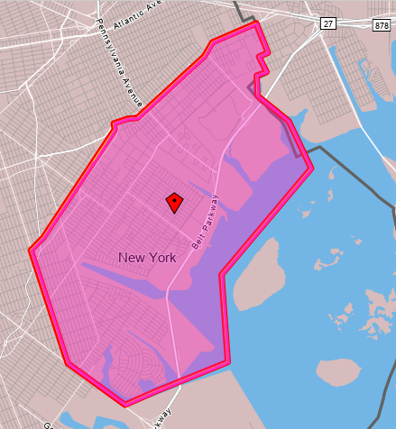
This is on net a bedroom community. In 2019, it had 85,427 employed residents and 39,382 jobs. Very few people both live and work in this area – only 4,005. This is an even smaller proportion than is typical in the city, where 8% of employed city residents work in the same community board they live in – the study zone is slightly smaller than Brooklyn Community Board 18, but CB 18 writ large also has a lower than average share of in-board workers.
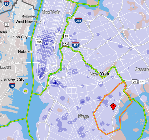
In contrast with the limited extent of in-zone work travel, nearly all employed zone residents, 76,534, work in the city as opposed to its suburbs (and 31,685 of the zone’s 39,382 jobs are held by city residents). Where they work looks like where city workers work in general, since the transportation system other than the Shore Parkway is so radial:
Within the zone, the southwestern areas, that is Mill Basin and Bergen Beach, are vaguely near Utica Avenue, hosting the B46 and hopefully in the future a subway line, first as an extension of the 4 train and later as an independent trunk line.
To the northeast, Canarsie, Starrett City, and Spring Creek are all far from the subway, and connect to it by dedicated buses to an outer subway station – see more details on the borough’s bus map. Canarsie is connected to the L subway station named after it by the B42, a short but high-productivity bus route, and to the 3 and 4 trains at Utica by the B17, also a high-productivity route. Starrett City does not have such strong dedicated buses: it is the outer terminus of the circumferential B82 (which is very strong), but its dedicated radial route, the B83 to Broadway Junction, is meandering and has slightly below-average ridership for its length. Spring Creek is the worst: it is a commercial rather than residential area, anchored by the Gateway Center mall, but the mall is served by buses entering it from the south and not the north, including the B83, the B84 to New Lots on the 3 (a half-hourly bus with practically no ridership), the rather weak B13 to Crescent Street and Ridgewood, and the Q8 to Jamaica.
The implications for bus design
The paucity of east-west throughfares in this area deeply impacts how bus redesign in Brooklyn ought to be done, and this proved important when Eric and I wrote our bus redesign proposal.
First, there are so few crossings between Brooklyn and Queens that the routes crossing between the two boroughs are constrained and can be handled separately. This means that it’s plausible to design separate bus networks for Brooklyn and Queens. In 2018 it was unclear whether they’d be designed separately or together; the MTA has since done them separately, which is the correct decision. The difficulty of crossings argues in favor of separation, and so does the difference in density pattern between the two boroughs: Brooklyn has fairly isotropic density thanks to high-density construction in Coney Island, which argues in favor of high uniform frequency borough-wide, whereas Queens grades to lower density toward the east, which argues in favor of more and less frequent routes depending on neighborhood details.
Second, the situation in Starrett City is unacceptable. This is an extremely poor, transit-dependent neighborhood, and right now its bus connections to the rest of the world are lacking. The B82 is a strong bus route but many rush hour buses only run from the L train west; at Starrett City, the frequency is a local bus every 10-12 minutes and another SBS bus every 10-12 minutes, never overlying to produce high base frequency. The B83 meanders and has low ridership accordingly; it should be combined with the B20 to produce a straight bus route going direct on Pennsylvania Avenue between Starrett City and Broadway Junction, offering neighborhood residents a more convenient connection to the subway.
Third, the situation in Spring Creek is unacceptable as well. Gateway Center is a recent development, dating only to 2002, long after the last major revision of Brooklyn buses. The bus network grew haphazardly to serve it, and does so from the wrong direction, forcing riders into a circuitous route. Only residents of Starrett City have any direct route to the mall, but whereas Starrett City has 5,724 employed residents (south of Flatlands), and Spring Creek has 4,980 workers, only 26 people commute from Starrett City to Spring Creek. It’s far more important to connect Spring Creek with the rest of the city, which means buses entering it from the north, not the south. Our bus redesign proposal does that with two routes: a B6/B82 extension making this and not Starrett City the eastern anchor, and a completely redone B13 going directly north from the mall to New Lots and thence hitting Euclid Avenue on the A/C and Crescent Street on the J/Z.
What about rail expansion?
New York should be looking at subway expansion, and not just Second Avenue Subway. Is subway expansion a good solution for the travel needs of this study zone?
For our purposes, we should start with the map of the existing subway system; the colors indicate deinterlining, but otherwise the system is exactly as it is today, save for a one-stop extension of the Eastern Parkway Line from New Lots to the existing railyard.

Starrett City does not lie on or near any obvious subway expansion; any rail there has to be a tram. But Canarsie is where any L extension would go – in fact, the Canarsie Line used to go there until it was curtailed to its current terminus in 1917, as the trains ran at-grade and grade-separating them in order to run third rail was considered impractically expensive. Likewise, extending the Eastern Parkway Line through the yard to Gateway Center is a natural expansion, running on Elton Street.
Both potential extensions should be considered on a cost per rider basis. In both cases, a big question is whether they can be built elevated – neither Rockaway Parkway nor Elton is an especially wide street most of the way, about 24 or 27 meters wide with 20-meter narrows. The Gateway extension would be around 1.3 km and the Canarsie one 1.8 km to Seaview Avenue or 2.3 km to the waterfront. These should cost around $250 million and $500 million respectively underground, and somewhat less elevated – I’m tempted to say elevated extensions are half as expensive, but this far out of city center, the underground premium should be lower, especially if cut-and-cover construction is viable, which it should be; let’s call it two-thirds as expensive above-ground.
Is there enough ridership to justify such expansion?
Let’s start with Canarsie, which has 28,515 employed residents between Flatlands and the water. Those workers mostly don’t work along the L, which manages to miss all of the city’s main job centers, but the L does have good connections to lines connecting to Downtown Brooklyn (A/C), Lower Manhattan (A/C again), and Midtown (4/5/6, N/Q/R/W, F/M, A/C/E). Moreover, the density within the neighborhood is uniform, and so many of the 28,515 are not really near where the subway would go – Rockaway/Flatlands, Rockaway/Avenue L, Rockaway/Seaview, and perhaps Belt Parkway for the waterfront. Within 500 meters of Rockaway/L and Rockaway/Seaview there are only 9,602 employed residents, but then it can be expected that nearly all would use the subway.
The B42 an B17 provide a lower limit to the potential ridership of a subway extension. The subway would literally replace the B42 and its roughly 4,000 weekday riders; nearly all of the 10,000 riders of the B17 would likely switch as well. What’s more, those buses were seeing decreases in ridership even before corona due to traffic and higher wages inducing people to switch away from buses – and in 2011, despite high unemployment, those two routes combined to 18,000 weekday riders.
If that’s the market, then $500 million/18,000 weekday riders is great and should be built.
Let’s look at Gateway now. Spring Creek has 4,980 workers, but first of all, only 3,513 live in the city. Their incomes are very low – of the 3,513, only 1,030, or 29%, earned as much as $40,000/year in 2019 – which makes even circuitous mass transit more competitive with cars. There’s a notable concentration of Spring Creek workers among people living vaguely near the 3/4 trains in Brooklyn, which may be explained by the bus connections; fortunately, there’s also a concentration among people living near the proposed IBX route in both Brooklyn and Queens.
The area is the opposite of a bedroom community, unlike the other areas within the study zone – only 1,114 employed people live in it. Going one block north of Flatlands boosts this to 1,923, but a block north of Flatlands it’s plausible to walk to a station at Linden at the existing railyard. 51% of the 1,114 and 54% of the 1,923 earn at least $40,000 a year. Beyond that, it’s hard to see where neighborhood residents work – nearly 40% work in the public sector and OnTheMap’s limitations are such that many of those are deemed to be working at Brooklyn Borough Hall regardless of their actual commute destination.
There’s non-work travel to such a big shopping center, but there are grounds to discount it. It’s grown around the Shore Parkway, and it’s likely that every shopper in the area who can afford a car drives in; in Germany, with generally good off-peak frequency and colocation of retail at train stations, the modal split for public transit is lower for shopping trips than for commutes to work or school. Such trips can boost a Gateway Center subway extension but they’re likely secondary, at least in the medium run.
The work travel to the mall is thankfully on the margin of good enough to justify a subway at $50,000/daily trip, itself a marginal cost. Much depends on IBX, which would help deliver passengers to nearby subway nodes, permitting such radial extensions to get more ridership.
Adversarial Legalism and Accessibility
New York State just announced that per the result of a legal settlement, it is committing to make 95% of the subway accessible… by 2055. Every decade, 80-90 stations will be made accessible, out of 472. Area advocates for disability rights are elated; in addition to those cited in the press release or in the New York Times article covering the news, Effective Transit Alliance colleague Jessica Murray speaks of it as a great win and notes that, “The courts are the only true enforcement mechanism of the Americans with Disabilities Act.” But to me, it’s an example not of the success of the use of the courts for civil rights purposes, in what is called adversarial legalism, but rather its failure. The timeline is a travesty and the system of setting the government against itself with the courts as the ultimate arbiter must be viewed as a dead-end and replaced with stronger administration.
The starting point for what is wrong is that 2055 is, frankly, a disgrace. By the standards of most other old urban metro systems, it is a generation behind. In Berlin, where the U-Bahn opened in 1902, two years before the New York City Subway did, there has been media criticism of BVG for missing its 2022 deadline for full accessibility; 80% of the system is accessible, and BVG says that it will reach 100% in 2024. Madrid is slower, planning only for 82% by 2028, with full accessibility possible in the 2030s. Barcelona is 93% accessible and is in the process of retrofitting its remaining stations. Milan has onerous restrictions such that only one wheelchair user may board each train, but the majority of stations have elevators, and 76% have elevators or stairlifts. In Tokyo, Toei is entirely accessible, and so is nearly the entirety of Tokyo Metro. Even London is 40% accessible, somewhat ahead of New York. Only Paris stands as a less accessible major world metro system.
The primary reason for this is costs. The current program to make 81 stations accessible by 2025 is $5.2 billion. This is $64 million per station, and nearly all are single-line stations requiring three elevators, one between the street and the outside of fare control and one from just inside fare control to each of two side platforms. Berlin usually only requires one elevator as it has island platforms and no fare barriers, but sometimes it needs two at stations with side platforms, and the costs look like 1.5-2 million € per elevator. Madrid the cost per elevator is slightly higher, 3.2 million €. New York, in contrast, spends $20 million, so that a single station in New York is comparable in scope to the entirety of the remainder of the Berlin U-Bahn.
And this is what adversarial legalism can’t fix. The courts can compel the MTA to install elevators, but have no way of ensuring the MTA do so efficiently. They can look at capital plans and decree that a certain proportion be spent on accessibility; seeing $50 billion five-year capital plans, they can say, okay, you need to spend 5-10% of that on subway accessibility. But if the MTA says that a station costs $64 million to retrofit and therefore there is no room in the budget to do it by 2030, the courts have to defer.
This, in turn, is a severe misjudgment of what the purpose of civil rights legislation is. Civil rights laws giving individuals and classes the right to sue the government already presuppose that the government may be racist, sexist, or ableist. This is why they confer individual and group rights to sue under Title VI (racial equality in transportation and other facilities), Title IX (gender equality in education), and the ADA. If the intention was to defer to the judgment of government agencies, no such laws would be necessary.
And yet, the nature of adversarial legalism is that on factual details, courts are forced to defer to government agencies. If the MTA says it costs $64 million to retrofit a station, the courts do not have the power to dismiss managers and hire people who can do it for $10 million. If the MTA says it has friction with utilities, the courts cannot compel the utilities to stop being secretive and share the map of underground infrastructure in the city or to stop being obstructive and start cooperating with the MTA’s contractors when they need to do street work to root an elevator. Judges are competent in legal analysis and incompetent in planning or engineering, and this is the result.
Worse, the adversarial process encourages obstructive behavior. The response to any request from the public or the media soon becomes “make me”; former Capital Construction head and current MTA head Janno Lieber said “file a Freedom of Information request” to a journalist who asked what 400 questions federal regulators asked regarding congestion pricing. Nothing goes forward this way, unless accessibility in 33 years counts, and it shouldn’t.
How Washington Should Spend $10 Billion
The planned $10 billion expansion of Washington Union Station is a waste of money, but this does not mean that money appropriated for public transportation in the National Capital Region is a waste. The region has real transportation needs that should be addressed through urban rail expansion – just not through a rebuild of the intercity rail station. Those needs include local and regional travel, to be addressed through investment in both the Metro and the commuter rail networks. It is fortunate that when I probed on Twitter, there was broad if imperfect agreement among area advocates about what to do.
A $10 billion budget should be spent predominantly on new Metro Rail lines, carefully chosen to satisfy multiple goals at once: physical expansion of the reach of the system, additional core capacity, and deinterlining to improve reliability and increase the capacity of existing lines. For the purposes of the question I posed to area advocates, I set the expansion budget at $7.5 billion, good for 30 km at average global prices, leaving the rest for commuter rail improvements.
What to do about commuter rail
Washington does not have a large legacy commuter rail network, unlike New York, Chicago, Boston, or Philadelphia. It is not as old as those cities, and its conception as the southern end of an East Coast region stretching up to Boston is postwar, by which point investment in passenger rail was largely relegated to the past. Nonetheless, it does have some lines, three to the north as the MARC system and two to the south as the VRE system. They should be upgraded to better commuter rail standards.
Union Station already has the infrastructure for through-running. The junction between the through-tunnel and the terminal tracks is flat, and almost all intercity trains terminate and most will indefinitely no matter how much investment there is in high-speed rail to points south. This requires delicate scheduling, which is good up to about 18 trains per hour in each direction, either six through- and 12 terminating or the other way around. Running half-hourly all-day service on each of the lines, with some additional urban overlay in Virginia and extra service on the Penn Line to Baltimore, should not be too difficult.
Thus, the main spending items on the agenda are not new tracks, but electrification and high platforms. MARC runs diesel trains even under catenary on the Northeast Corridor, which problem requires no additional electrification to fix, but its other two lines are unelectrified, and VRE has no electrification infrastructure. Those lines total 327 route-km of required wiring, with extensive single-tracking reducing per-km cost; this should be around $600 million. But note that they all carry significant freight traffic, and additional accommodations may be necessary.
As far as platforms go, there are nearly 50 stations requiring high platforms (I think 49 but I may have miscounted). At Boston costs it should be $1 billion or a bit more, but that’s for long trains, and MARC trains are not so long, and a system based on shorter trains at higher frequency would be somewhat cheaper. Infill stations are probably unnecessary – there are Metro Rail lines along the inner sections of most of the lines providing the urban rail layer.
Metro Rail expansion
The most pressing problem WMATA’s trains have is poor reliability. Two changes in the late 2000s and 2010s made the system worse: the 2009 elimination of automatic (though not driverless) operations worsened ride quality and reducing capacity, and the 2014 opening of the Silver Line introduced too much interlining reducing both reliability and capacity. WMATA is aware of the first problem and is working to restore ATO; the Silver Line’s problems should be fixed through judicious use of deinterlining. Deinterlining by itself only requires a short extension of the Yellow Line to separate the lines, but it can be bundled with further expansion.
Consensus among area advocates is that there should be separate tunnels for the Yellow and Blue Lines and a new trunk line under Columbia Pike, which three lines total 21 km. Additional lines can consist of another trunk line going northeast from Union Station between the Brunswick and Camden Lines or an extension of the Columbia Pike line from Bailey’s Crossroads, the present outer limit of high density, to Annandale, which would require extension transit-oriented development along the line.
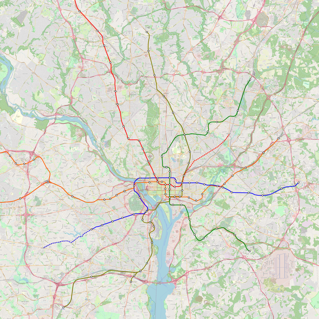
A full-size version can be found here; note that the lines at Union Station are moved around to get rid of the Red Line’s awkward U-shape. The northeast extension option is colored red but should be a Blue Line extension, but the Red Line taking over H Street and going to Largo.
Watch Our Webinar on Construction Costs Tomorrow
The Italy case, done by Marco Chitti, is up on the website. I encourage people to read the entire report on how Italy has set things up in the last 20-30 years so as to have one of the lowest-cost urban rail infrastructure programs in the world. The Turkey case, by Elif Ensari, will be up shortly.
This is leading to a webinar, to be done tomorrow at 16:00 my time, 10:00 New York time, in which Marco and Elif will present their cases to the general public. I encourage people to register; you’ll be able to ask us questions and we’ll answer in chat or on video. But if you can’t make it, it will be recorded.
Systemic Investments in the New York City Subway
Subway investments can include expansion of the map of lines, for example Second Avenue Subway; proposals for such extensions are affectionately called crayon, a term from London Reconnections that hopped the Pond. But they can also include improvements that are not visible as lines on a map, and yet are visible to passengers in the form of better service: faster, more reliable, more accessible, and more frequent.
Yesterday I asked on Twitter what subway investments people think New York should get, and people mostly gave their crayons. Most people gave the same list of core lines – Second Avenue Subway Phase 2, an extension of the 2 and 5 on Nostrand, an extension of the 4 on Utica, an extension of the N and W to LaGuardia, the ongoing Interborough Express proposal, and an extension of Second Avenue Subway along 125th – but beyond that there’s wide divergence and a lot of people argue over the merits of various extensions. But then an anonymous account that began last year and has 21 followers and yet has proven extremely fluent in the New York transit advocacy conversation, named N_LaGuardia, asked a more interesting question: what non-crayon systemic investments do people think the subway needs?
On the latter question, there seems to be wide agreement among area technical advocates, and as far as I can tell the main advocacy organizations agree on most points. To the extent people gave differing answers in N_LaGuardia’s thread, it was about not thinking of everything at once, or running into the Twitter character limit.
It is unfortunate that many of these features requiring capital construction run into the usual New York problem of excessive construction costs. The same institutional mechanisms that make the region incapable of building much additional extension of the system also frustrate systemwide upgrades to station infrastructure and signaling.
Accessibility
New York has one of the world’s least accessible major metro systems, alongside London and (even worse) Paris. In contrast, Berlin, of similar age, is two-thirds accessible and planned to reach 100% soon, and the same is true of Madrid; Seoul is newer but was not built accessible and retrofits are nearly complete, with the few remaining gaps generating much outrage by people with disabilities.
Unfortunately, like most other forms of capital construction in New York, accessibility retrofits are unusually costly. The elevator retrofits from the last capital plan were $40 million per station, and the next batch is in theory $50 million, with the public-facing estimates saying $70 million with contingency; the range in the European cities with extensive accessibility (that is, not London or Paris) is entirely single-digit million. Nonetheless, this is understood to be a priority in New York and must be accelerated to improve the quality of universal design in the system.
Platform screen doors
The issue of platform screen doors (PSDs) or platform edge doors (PEDs) became salient earlier this year due to a much-publicized homicide by pushing a passenger onto a train, and the MTA eventually agreed to pilot PSDs at three stations. The benefits of PSDs are numerous, including,
- Safety – there are tens of accident and suicide deaths every year from falling onto tracks, in addition to the aforementioned homicide.
- Greater accessibility – people with balance problems have less to worry about from falling onto the track.
- Capacity – PSDs take up platform space but they permit passengers to stand right next to them, and the overall effect is to reduce platform overcrowding at busy times.
- Air cooling – at subway stations with full-height PSDs (which are rare in retrofits but I’m told exist in Seoul), it’s easier to install air conditioning for summer cooling.
The main difficulty is that PSDs require trains to stop at precise locations, to within about a meter, which requires signaling improvements (see below). Moreover, in New York, trains do not yet have consistent door placement, and the lettered lines even have different numbers of doors sometimes (4 per car but the cars can be 60′ or 75′ long) – and the heavily interlined system is such that it’s hard to segregate lines into captive fleets.
But the biggest difficulty, as with accessibility, is again the costs. In the wake of public agitation for PSDs earlier this year, the MTA released as 2019 study saying only 128 stations could be retrofitted with PSDs, at a cost of $7 billion each, or $55 million per station; in Paris, PSDs are installed on Métro lines as they are being automated, at a cost of (per Wikipedia) 4M€ per station of about half the platform length as in New York.
Signaling improvements
New York relies on ancient signaling for the subway. This leads to multiple problems: maintenance is difficult as the international suppliers no longer make the required spare parts; the signals are designed around the performance specs of generations-old trains and reduce capacity on more modern trains; the signals are confusing to drivers and therefore trains run slower than they can.
To modernize them, New York is going straight to the most advanced system available: CBTC, or communications-based train control, also known as moving-block signaling. This is already done on the L and 7 trains and is under installation on other lines, which are not isolated from the rest of the system. CBTC permits much higher peak capacity in London; in New York, unfortunately, this effect has been weaker because of other constraints, including weak electrical substation capacity and bumper tracks at the terminals of both the L and the 7.
Moreover, in New York, the L train’s performance was derated when CBTC was installed, to reduce brake wear. The effect of such computer control should be the opposite, as computers drive more precisely than humans: in Paris, the automation of Line 1 led to a speed increase of 15-20%, and CBTC even without automation has the same precision level as full automation.
As before, costs form a major barrier. I can’t give the most recent analogs, because such projects tend to bundle a lot of extras, such as new trainsets and PSDs in Paris. In Nuremberg, the first city in the world to permanently convert a preexisting metro system to driverless operations, the cost of just the driverless system is said to have been 110M€ in the late 2000s, for what I believe is 13 km of U2 (U3 was built with driverless operations in mind, and then U2, from which it branches, was converted). It is said that automating U1 should cost 100M€ for 19.5 km, but this project is not happening due to stiff competition for federal funds and therefore its real cost is uncertain. In contrast, Reinvent Albany quotes $636 million for the 7 train in New York, of which $202 million must be excluded as rolling stock conversion; the Flushing Line is 16 km long, so this is still $27 million/km and not the $7-12 million/km of Nuremberg.
Maintenance regime
The maintenance regime in New York involves heavy slowdowns and capacity restrictions. Trains run 24/7 without any breaks for regular maintenance. Instead, maintenance is done one track at a time during off-peak periods, with flagging rules that slow down trains on adjacent tracks and have gotten more onerous over the last 10-20 years; only recently have planners begun to use temporary barriers to reduce the burden of flagging.
The result of this system is threefold. First, track maintenance productivity is extremely low – the train on an adjacent track slows down as it passes but the work stops as it passes as well. Second, speeds are unreliable off-peak and the timetable is in perpetual firefighting mode. And third, parts of the system are claimed to be incapable of running more than about 16 trains per hour off-peak, which means that if there is any branching, the branches are limited to 8, which is not enough frequency on a major urban metro system.
It takes a small amount of capital spending to increase efficiency of maintenance, through procuring more advanced machinery, installing barriers between tracks, and installing crossovers at appropriate locations. But it takes a large degree of operations and management reform to get there, which is necessary for reducing the high operating costs of the subway.
Deinterlining
New York has the most complicated interlining of any global metro network. Only four lines – the 1, 6, 7, and L – run by themselves without any track sharing with other lines. The 2, 3, 4, and 5 share tracks with one another. Then the lettered trains other than the L all share tracks on various segments, without any further segregation. Only some commuter rail networks are more complex than this – and even Tokyo has greater degree of segregation between different trunk lines, despite extensive through-service to commuter rail. The New York way guarantees more direct service on more origin-destination pairs, but at low frequency and with poor speed and reliability.
London, the second most interlined system, has long wanted to reduce interlining to increase capacity. The Northern line traditionally had just one southern segment reverse-branching to two central trunks, combining and splitting into two northern branches. When CBTC opened, the busier of the central trunks got 26 peak trains per hour; the more recent Battersea extension removed the interlining to the south, permitting boosting capacity up to 32 tph, and full deinterlining to the north would boost it to 36 tph, as on the most captive Underground lines.
In New York, it is desirable to remove all reverse-branching. At DeKalb Avenue in Downtown Brooklyn, the interlocking switches the four express (bridge) tracks from an arrangement of the B and D on one track pair and the N and Q on the other to the B and Q on one track pair and the D and N on the other; the process is so complex that every train is delayed two minutes just from the operation of the switches. Everywhere within the system, interlining creates too much dependency between the different trains, so that delays on one line propagate to the others, reducing reliability, speed, and capacity.
Some of the problem is, as usual, about high costs. Rogers Avenue Junction controls the branching of the 2, 3, 4, and 5 trains in Brooklyn, transitioning from the 2 and 3 sharing one track pair and the 4 and 5 sharing another to the 3 and 4 running on dedicated tracks and the 2 and 5 sharing tracks. For a brief segment, the 2, 3 and 5 trains all share tracks. This devastates capacity on both trunk lines, which rank first and third citywide in peak crowding as of the eve of the opening of Second Avenue Subway. There are already internal designs for rebuilding the junction to avoid this problem – at a cost of $300 million.
But some of the problem is also about operating paradigms. New York must move away from the scheduling ideas of the 1920s and 30s and understand that independently-operated lines with dedicated fleets and timetables, with passengers making transfers as appropriate, are more robust and overall better for most riders. DeKalb can be deinterlined with no capital spending at all, and so can Columbus Circle. It’s Rogers and Queens Plaza where spending is ideal (but even then, not strictly required if some operational compromises are made), and the 142nd Street Junction in Harlem where an extensive rebuild is obligatory in order to permit splitting the 2 from the 5 in the Bronx permanently.
Labor changes
Staffing levels in New York are very high. Trains have conductors and not just drivers; this is not globally unheard of (Toronto and some lines in Tokyo still have conductors) but it’s rare. With good enough signaling, a retrofit even for full automation is possible, as in Nuremberg, Paris, and Singapore. Maintenance work is likewise unproductive, not because people don’t work hard, but because they work inefficiently.
Improving this situation involves changes on both sides of the ledger – staffing and service. Conductors have to be cut for efficiency and not all of them can be absorbed by other roles, and the same is true of some station facilities and maintenance functions. In contrast, the low productivity of drivers in New York – they spend around 550 hours a year driving a revenue train whereas Berlin’s drivers, who get 6 weeks of annual paid vacation, scratch 900 – is the result of poor off-peak frequency, and must be resolved through increases in off-peak service that increase efficiency without layoffs.
Ultimate goal: six-minute service
I wrote two years ago about what it would take to ensure every public transit service in New York runs every six minutes off-peak, calling it a six-minute city.
Riders Alliance argues for the same goal, with the hashtag #6minuteservice; I do not know if they were basing this on what I’d written or if it’s convergent evolution. But it’s a good design goal for timetabling, with implications for labor efficiency, maintenance efficiency, the schedule paradigm, and the bus system.
No tradeoffs
It is fortunate that the agenda of systemwide improvements does not exhibit significant tradeoffs in investment. Other parts of the transit agenda do not need to suffer to implement those improvements. On the contrary, they tend to interact positively: accessibility and PSDs can be combined (and federal law is written in such a way that PSDs void the grandfather clause permitting the subway to keep most of its stations inaccessible), faster and more reliable trains can be run more frequently off-peak, better service means higher ridership and therefore higher demand for extensions. Only the issue of labor exhibits a clear set of losers from the changes, and those can be compensated in a one-time deal.
Moreover, the budget for such an agenda is reasonable, if New York can keep its construction costs under control. At the per-elevator costs of Berlin or Madrid, New York could make its entire network wheelchair-accessible for around $3.5-4 billion. Parisian PSDs, pro-rated to the greater size of New York trains, would be around $10 million a station, or $5 billion systemwide. Full automation at German costs would be maybe $6 billion with triple- and quad-track lines pro-rated. The entire slate of changes required for full deinterlining, including a pocket track for the 3 train at 135th Street, a rebuild of the 36th Street station in Queens, and a connection between Queensboro Plaza and Queens Plaza, should be measured in the hundreds of millions, not billions.
The overall program still goes into double-digit billions; it requires a big push. But this big push is worth two to three years’ worth of current New York City Transit capital spending. A New York that can do this can also add 50-100 km to its subway network and vice versa, all while holding down operating costs to typical first-world levels. For the most part, the planners already know what needs to be done; the hard part is getting construction costs to reasonable levels so that they can do it on the current budget.
How Comparisons are Judged
I’m about to complete the report for the Transit Costs Project about Sweden. For the most part, Sweden is a good comparison case: its construction costs for public transport are fairly low, as are those of the rest of Scandinavia, and the projects being built are sound. And yet, the Nordic countries and higher-cost countries in the rest of Northern Europe, that is Germany and the Netherlands, share a common prejudice against Southern Europe, which in the last decade or so has been the world leader in cost-effective infrastructure. (Turkey is very cheap as well but in many ways resembles Southern Europe, complete with having imported Italian expertise early on.)
This is not usually an overt prejudice. Only one person who I’ve talked to openly discounted the idea that Italy could be good at this, and they are not Nordic. But I’ve been reading a lot of material out of Nordic countries discussing future strategy, and it engages in extensive international comparisons but only within Northern Europe, including high-cost Britain, ignoring Southern Europe. The idea that Italians can be associated with good engineering is too alien to Northern Europeans.
The best way to illustrate it is with a toy model, about the concept of livable cities.
Livable cities
Consider the following list of the world’s most livable cities:
- Vienna
- Stockholm
- Auckland
- Zurich
- Amsterdam
- Melbourne
- Geneva
- Copenhagen
- Munich
- Vancouver
The list, to be clear, is completely made up. These are roughly the cities I would expect to see on such a list from half-remembering Monocle’s actual lists and some of the discourse that they generate: they should be Northern European cities or cities of the peripheral (non-US/UK) Anglosphere, and not too big (Berlin might raise eyebrows). These are the cities that urbanist discourse associates with livability.
The thing is, prejudices like “Northern Europe is just more livable” can tolerate a moderate level of heresy. If I made the above list, but put Taipei at a high place shifting all others down and bumping Vancouver, explaining this on grounds like Taipei’s housing affordability, strong mass transit system, and low corona rates (Taiwan spent most of the last two years as a corona fortress, though it’s cracked this month), it could be believed. In effect, Taipei’s status as a hidden gem could be legitimized by its inclusion on a list alongside expected candidates like Vienna and Stockholm.
But if instead the list opened with Taipei, Kaohsiung, Taichung, and Tainan, it would raise eyebrows. This isn’t even because of any real criteria, though they exist (Taiwan’s secondary cities are motorcycle- and auto-oriented, with weak metro systems). It just makes the list too Taiwanese, which is not what one expects from such a list. Ditto if the secondary Taiwanese cities were bumped for other rich Asian cities like Singapore or Seoul; Singapore is firmly in the one-heresy status – it can make such a list if every other city on the list is as expected – but people have certain prejudices of how it operates and certain words they associate with it, some right and some laughably wrong, and “livable” is not among them.
The implication for infrastructure
A single number is more objective than a multi-factor concept like livability. In the case of infrastructure, this is cost per kilometer for subways, and it’s possible to establish that the lowest-cost places for this are Southern Europe (including Turkey), South Korea, and Switzerland. The Nordic countries used to be as cheap but with last decade’s cost overruns are somewhat more expensive to dig in, though still cheaper than anywhere else in the world; Latin America runs the gamut, but some parts of it, like Chile, are Sweden-cheap.
Per the one-heresy rule, the low costs of Spain are decently acknowledged. Bent Flyvbjerg even summarized the planning style of Madrid as an exemplar of low costs recently – and he normally studies cost overruns and planning failures, not recipes for success. But it goes deeper than just this, in a number of ways.
- While Madrid most likely has the world’s lowest urban subway costs, the rest of Southern Europe achieves comparable results and so does South Korea. So it’s important to look at shared features of those places and learn, rather than just treat Spain as an odd case out while sticking with Northern European paradigms.
- Like Italy, Spain has not undergone the creeping privatization of state planning so typical in the UK and, through British soft power, other parts of Northern Europe. Design is done by in-house engineers; there’s extensive public-sector innovation, rather than an attempt to activate private-sector innovation in construction.
- Southern European planning isn’t just cheap, but also good. Metro Milano says that M5 carries 176,000 passengers per day, for a cost of 1.35b€ across both phases; in today’s money it’s around $13,000 per rider, which is fairly low and within the Nordic range. Italian driverless metros push the envelope on throughput measured in peak trains per hour, and should be considered at the frontier of the technology alongside Paris. Milan, Barcelona, and Madrid have all been fairly good at installing barrier-free access to stations, roughly on a par with Berlin; Madrid is planning to go 100% accessible by 2028.
- As a corollary of point #3, there are substantial similarities between Southern and Northern Europe. In particular, both were ravaged by austerity after the financial crisis; Northern Europe quickly recovered economically, but in both, infrastructure investment is lagging. In general, if you keep finding $10,000/rider and $15,000/rider subways to build, you should be spending more money on more subway lines. Turkey is the odd one out in that it builds aggressively, but on other infrastructure matters it should be viewed as part of the European umbrella.
- Italian corruption levels in infrastructure are very low, and from a greater distance this also appears true of Spain. Italy’s governance problems are elsewhere – the institutional problems with tax avoidance drag down the private sector, which has too many family-scale businesses that can’t grow and too few large corporations, and not the public sector.
I’m not going to make a list of the cities with the best urban rail networks in the world, even in jest; people might take this list as authoritative in ways they wouldn’t take a list I made up about livability. But in the same way that there are prejudices that militate in favor of associating livability with Northern Europe and the peripheral Anglosphere, there are prejudices that militate in favor of associating good public transport with Northern and Central Europe and the megacities of rich Asia. All of those places indeed have excellent public transportation, but this is equally true of the largest Southern European cities; Istanbul is lagging but it’s implementing two large metro networks, one for Europe and one for Asia, and already has Marmaray connecting them under the Bosporus.
And what’s more, just as Southern Europe has things to learn from Northern Europe, Northern Europe has things to learn from the South. But it doesn’t come naturally to Germans or Nordics. It’s expected that every list of the best places in Europe on every metric should show a north-south gradient, with France anywhere in between. If something shows the opposite, it must in this schema be unimportant, or even fraudulent. Northerners know that Southerners are lazy and corrupt – when they vacation in Alicante they don’t see anyone work outside the hospitality industry, so they come away with the conclusion that there is no high-skill professional work in the entire country.
But at a time when Germany is building necessary green infrastructure at glacial rates and France and Scandinavia have seen real costs go up maybe 50% in 20 years, it’s necessary to look beyond the prejudice. Madrid, Barcelona, Rome, Milan, Istanbul, Lisbon, and most likely also Athens have to be treated as part of the European core when it comes to urban rail infrastructure, with as much to teach Stockholm as the reverse and more to teach Berlin than the reverse.
Consolidating Stops with Irregular Spacing
There was an interesting discussion on Twitter a few hours ago about stop consolidation on the subway in New York. Hayden Clarkin, the founder of TransitCon, brings up the example of 21st Street on the G in Long Island City. The stop is lightly-used and very close to Court Square, which ordinarily makes it a good candidate for removal, a practice that has been done a handful of times in the city’s past. However, the spacing is irregular and in context this makes the stop’s removal a lower-value proposition; in all likelihood there should not be any change and trains should keep calling at the station as they do today.
What is 21st Street?
The G train, connecting Downtown Brooklyn with Long Island City directly, makes two stops in Queens today: Court Square, at the southern end of the Long Island City business district, and 21st Street, which lies farther south. Here is a map of the area:
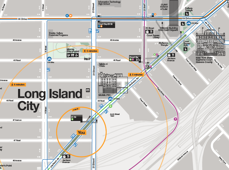
At closest approach, the platforms of 21st are 300 meters away from those of Court Square on the G; taking train length into account, this is around 400 meters (the G runs short trains occupying only half the platform). Moreover, Court Square is a more in-demand area than 21st Street: Long Island City by now near-ties Downtown Brooklyn as the largest job center in the region outside Manhattan, and employment clusters around Queens Plaza, which used to be one stop farther north on the G before the G was curtailed to Court Square in order to make more room for Manhattan-bound trains at Queens Plaza. Court Square is still close to jobs, but 21st Street is 400 meters farther away from them, with little on its side of the neighborhood.
Stop spacing optimization
Subways cannot continuously optimize their stop spacing the way buses can. Building a new bus stop costs a few thousand dollars, or a few ten thousand if you’re profligate. Building a new subway stop costs tens of millions, or a few hundred million if you’re profligate. This means that the question of subway stop optimization can only truly be dealt with during the original construction of a line. Subsequently, it may be prudent to build a new stop but only at great expense and usually only in special circumstances (for example, in the 1950s New York built an infill express station on the 4 and 5 trains at 59th, previously a local-only station, to transfer with the N, R, and W). But deleting a stop is free; New York has done it a few times, such as at 18th Street on the 6 trains or 91st on the 1. Is it advisable in the case of 21st?
The answer has to start with the formula for stop spacing. Here is my earliest post about it, in the context of bus stops. The formula is,

The factor of 4 in the formula depends on circumstances. If travel is purely isotropic along the line, then the optimum is at its minimum and the factor is 2. The less isotropic travel is, the higher the factor; the number 4 is when origins are purely isotropic, which reflects residential density in this part of New York, but destinations are purely anisotropic and can all be guaranteed to be at distinguished nodes, like business centers and transfer points. Because 21st Street is a residential area and Court Square is a commercial area and a transfer point, the factor of 4 is justified here.
Walk speed is around 1.33 m/s, the walk penalty is typically 2, the stop penalty on the subway is around 45 seconds, and the average unlinked trip on the subway is 6.21 km; the formula spits out an optimum of 863 m, which means that a stop that’s 400 meters from nearby stops should definitely be removed.
But there’s a snag.
The effect of irregular stop spacing
When the optimal interstation is 863 meters, the rationale for removing a stop that’s located 400 meters from adjacent stations is that the negative impact of removal is limited. Passengers at the stop to be removed have to walk 400 meters extra, and passengers halfway between the stop and either of the adjacent stops have no more walking to do because they can just walk to the other stop; the average extra walk is then 200 meters. The formula is based on minimizing overall travel time (with a walk penalty) assuming that removing a stop located x meters from adjacent stops incurs an extra walk of x/2 meters on average near the station. Moreover, only half of the population lives near deleted stops, so the average of x/2 meters is only across half the line.
However, this works only when stop spacing is regular. If the stop to be removed is 400 meters from an adjacent stop, but much farther from the adjacent stop on the other side, then the formula stops applying. In the case of 21st Street, the next stop to the south, Greenpoint Avenue, is 1.8 km away in Brooklyn, across an unwalkable bridge. Removing this stop does not increase the average walk by 200 meters but by almost 400, because anywhere from 21st south in Long Island City the extra walk is 400. Moreover, because this is the entire southern rim of Long Island City, this is more than just half the line in this area.
In the irregular case, we need to halve the factor in the formula, in this case from 4 to 2 (or from 2 to 1 if travel is isotropic). Then the optimum falls to 610; this already takes into account that 21st Street is a weaker-demand area than Court Square, or else the factor in the formula would drop by another factor of 2. At 610 meters, the impact of removing a stop 400 meters from an adjacent stop is not clearly positive. In the long run, it is likely counterproductive, since Long Island City is a growth area and demand is likely to grow in the future.
Does this generalize?
Yes!
In New York, this situation occurs at borough boundaries, and also at the state boundary if more service runs between the city and New Jersey. For example, in retrospect, it would have been better for the east-west subway lines in Manhattan to make a stop at 1st or 2nd Avenue, only 300-500 meters from the typical easternmost stop of Lexington. The L train does this, and if anything does not go far enough – there’s demand for opening a new entrance to the 1st Avenue stop (which is one of the busiest on the line) at Avenue A, and some demand for a likely-infeasible infill stop at Avenue C. These are all high-density areas, but they’re residential – most people from Queens are not going to 2nd Avenue but to Lex and points west, and yet, 2nd would shorten the walk for a large group of residential riders by around 400 meters, justifying its retrospective inclusion.
No Federal Aid to Transit Operations, Please
This is the third in a series of four posts about the poor state of political transit advocacy in the United States, following posts about the Green Line Extension in metro Boston and free public transport proposals, to be followed by an Urban Institute report by Yonah Freemark.
In the United States, political transit activists in the last few years have set their eyes on direct federal aid for operating subsidies for public transport. Traditionally, this has not been allowed: federal aid goes to capital planning (including long-term maintenance), and only a small amount of money goes to operations, all in peripheral bus systems. Urban transit agencies had to operate out of fares and local and state money. Demands for federal aid grew during corona, where emergency aid to operations led to demands for permanent subsidies, and have accelerated more recently as corona recovery has flagged (New York’s subway ridership is only around 60% of pre-corona levels). But said demands remain a bad idea in the short and long terms.
In the early 20th century, when public transport was expected to support itself out of fares, operating costs grew with wages, but were tempered by improvements in efficiency. New York City Transit opened with ticket-takers at every subway entrances and a conductor for every two cars; within a generation this system was replaced with automatic turnstiles and one conductor per train. Kyle Kirschling’s thesis has good data on this, finding that by the 1930s, the system grew to about 16,000 annual car-miles (=26,000 car-km) per employee.
And then it has stagnated. Further increases in labor efficiency have not happened. Most American systems have eliminated conductors, often through a multi-decade process of attrition rather than letting redundant workers go, but New York retains them. The network today actually has somewhat less service per employee than in the 1930s, 14,000 car-miles as of 2010, because fixed costs are spread across a slightly smaller system. Compare this with JICA’s report for Mumbai Metro comparing Japanese cities: Tokyo Metro has 283,871,000 car-km (PDF-p. 254) on 8,474 employees (PDF-p. 9), which is 33,500/employee, and that’s without any automation and with only partially conductor-less operations; Yokohama gets 40,000.
Moreover, the timeline in the US matches the onset of subsidies, to some extent: state and local subsidies relieved efficiency pressure. In Canada, TTC saw this and lobbied against subsidies for its own operations in the 1960s, on the grounds that without a breakeven mandate, the unions would capture all surplus; it took until the 1970s for it to finally receive any operating subsidies.
Federal subsidies make all of this worse. They are other people’s money (OPM), so local agencies are likely to maximize them at the expense of good service; this is already what they do with capital money, lading projects with local demands for betterments figuring that if everyone else hogs the trough then they should as well.
Then there is the issue of wages. Seniority systems in American unionized labor create labor shortages even when pay is high, because of how they interact with scheduling and tiered wage structures. Bus drivers in Boston earn around $80,000 a year, a pay that German bus and train drivers can only dream of, but starting drivers are in probational status and have a lower wage (they are not even given full-time work until they put in a long period of part-time work). Moreover, because drivers pick their shifts in seniority order, drivers for about the first 10 years are stuck with the worst shifts: split shifts, graveyard shifts at inconsistent intervals, different garages to report to. New York manages to find enough bus drivers to fill its ranks but only by paying around $85,000 a year; other American cities, paying somewhat less, are seeing thousands of missed runs over the year because they can’t find drivers.
And outside aid does nothing to fix that. Quite to the contrary, it helps paper over these problems and perpetuates the labor gerontocracy. New York City Transit has learned to react to every crisis by demanding a new source of income; there is not enough political appetite for transparent taxation, so the city and state find ever more opaque sources of funds, avoiding political controversy over wanton inefficiency but creating more distortion than a broad income tax would.
Instead of subsidizing current consumption, a developmental state should subsidize production. Don’t pay money to hire more bus drivers; pay for automating subway systems, for better dispatching, for better planning around intermodal integration. Current American wages, not to mention the unemployment rate, scream “invest in labor-saving technology” and not “expand labor-intensive production.”