Midwestern Urban Geography and High-Speed Rail
I’ve been uploading videos about high-speed rail lately, of which the most recent, from a week ago, is a return to my attempt at producing a high-speed rail map proposal for the eastern half of the United States. I streamed and then blogged a map here with followup here, but having looked at the model more, I’d like to do a refinement – both to introduce a slightly bigger map and explain why it is so, and talk about the issue of connecting low-speed lines. Along the way, I feel like I must talk about an issue mentioned in comments occasionally about the politics of only connecting major metropolitan areas, especially since this map still has fewer lines than various state wishlists stapled by Amtrak; this is especially important because one of the motivations for this post is a criticism of current plans by Matt Yglesias.
The map
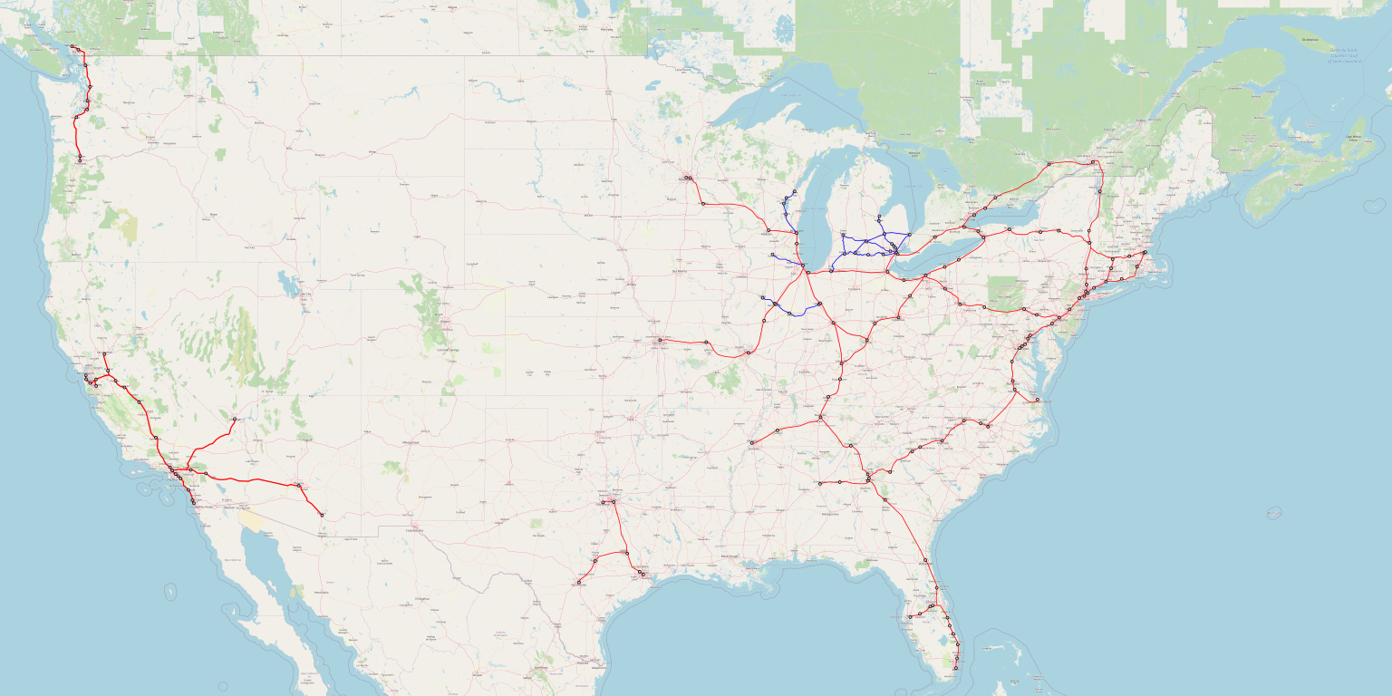
A full-size (6 MB) version of the map can be found here. This is not intended as a comprehensive map of all desirable low-speed connections – I made no effort to include the Northeastern ones, which I wrote about in the context of New England and Upstate New York, and which Ben She has done good work on in the context of eastern Pennsylvania and the mid-Atlantic. Rather, I want to focus on the Midwest.
But first, to explain a little more about why this map includes more red (high-speed) lines than previously, the reason has to do with my spreadsheet for computing ridership density based on Metcalfe’s law. The original posts computed everything by hand, which meant that some low-ridership city pairs I just rounded to zero; the spreadsheet does include them, making every line look much stronger. This, in particular, makes St. Louis-Kansas City and Atlanta-Birmingham, omitted last year, and Nashville-Memphis, suggested last year as a maybe, solid propositions.
A note of caution is still advised. Those weak city pairs that aggregate to sufficient ridership for significant return on investment are often at long distance, such as Kansas City-New York. The ridership model is trained on Shinkansen data out of Tokyo and sanity-checked with some French, German, and Spanish data, but the same model overpredicts Shinkansen ridership on inter-island trips for which planes are a convenient alternative, like Tokyo-Fukuoka or Tokyo-Hakodate. This makes me reluctant to add a Kansas City-Dallas connection, which the spreadsheet thinks generates a bit more than $1 million in annual operating profit per km of new construction: the extra ridership out of Kansas City-Dallas includes some very long-distance trips like Dallas-Detroit, for which the model is likely an overprediction.
The truth is likely between the spreadsheet and the handmade version of the model; while the Shinkansen is not competitive with planes when trains take five hours, European high-speed trains are, for example Paris-Nice. This leads to the inclusion of the new sections, but the exclusion of Kansas City-Dallas. Note also that I did look at Birmingham-New Orleans and Memphis-Little Rock, and both were weak even in the spreadsheet (though I did not attempt Birmingham-New Orleans-Houston) – the Deep South is too low-density and rural to support as expansive a system.
But the topic of this post is not the South, but the Midwest.
Midwestern urban geography
The United States is usually a country of fewer, bigger metropolitan areas, like rich Asia and unlike Europe; unlike both Europe and Asia, American cities are very decentralized, and the exceptions are in the Northeast and West, not the Midwest. In particular, naive comparisons of Midwestern to French high-speed rail corridors are unwarranted: while Chicago is of the same approximate size as Paris, and secondary Midwestern metropolitan areas like Detroit and St. Louis are substantially larger than French ones like Lyon and Marseille, Lyon and Marseille are ringed by many small metropolitan areas with their own TGV service, whereas at the same radius, St. Louis has only its suburbs.
However, this phenomenon of fewer, bigger metro areas has exceptions. Michigan, in particular, has a slightly more European geography. Using the smaller numbers produced by the metropolitan statistical area (MSA) calculation rather than the broader combined statistical area (CSA), Metro Detroit has 43% of Michigan’s population as of the 2020 census. The median Michigander lives in the Grand Rapids MSA, with 1.1 million people, fewer than the US-wide median of 1.6-1.7 million. Michigan is a fairly urban state, and below Grand Rapids is a succession of six-figure metropolitan areas: Ann Arbor, Lansing, Flint, Kalamazoo, Battle Creek, Saginaw.
Ohio is similar to Michigan. Its three main metro areas, excluding Cincinnati’s out-of-state suburbs, have just a hair less than half the state’s population; the median Buckeye therefore lives in Dayton, MSA population 800,000. Moreover, the southern half of Michigan has fairly high population density, as does Ohio – nothing as dense as the Northeast or Germany, but they’re comparable to France.
This geography lends itself to an expansive intercity rail network: the cities are relatively close to one another, and there are many of them meriting a connection. In Ohio, this happens to take the form of an entirely high-speed network, since Cleveland, Columbus, Dayton, and Cincinnati all lie on one line, and then the most natural east-west route between the Northeast and the Midwest passes through Cleveland and Toledo. Ohio, in this case, is a state with fairly good geography for low-speed intercity rail that just happens to also have good geography for high-speed rail due to its location. Michigan, in contrast, is not on the way between much, and thus should get a low-speed rail network, including both connections to Chicago (such as to Grand Rapids) and an intra-state network.
Wisconsin has many, smaller cities as well: the median resident is in an MSA of around 200,000 people, currently Racine. Fortunately, many of those cities lie on just one line between Chicago and Minneapolis, plus a low-speed branch up to Green Bay. Unfortunately, coverage is lacking by the standards of Ohio, Michigan, or much more big city-dominated Illinois and Minnesota.
Getting low-speed rail right
I am happy to report that in Michigan and Ohio at least, good projects for low-speed rail are pursued. When I streamed my video, I was told in Twitch chat that Michigan is looking into funding a Detroit-Lansing-Grand Rapids intercity train. Ohio likewise has long had ideas for a statewide network, beginning with the Cleveland-Cincinnati spine.
It is unfortunate that these projects are not planned well. In a future post, I should write more about the concept of the wrong project versus the right project done poorly; I obliquely pointed this out when writing about leakage in the context of urban transit, where some American cities have poor project prioritization (such as Los Angeles) whereas others choose more or less the right projects but execute them poorly (such as New York and San Francisco). In this schema, the current plans for low-speed rail are often the right project, done wrong.
What I mean by this is that there’s a set of best industry practices for getting low-speed (that is, legacy) rail right, emanating out of Germany and surrounding countries, especially Switzerland. These include,
- Integration of timetable planning and infrastructure, to minimize construction costs – if higher costs are acceptable, just build high-speed rail.
- A clockface all-day schedule with a minimum of one train every two hours, and ideally a train every hour if the distances are shorter or the cities are bigger.
- Timed connections at major nodes to both other intercity trains within the same network and regional mass transit (such as regional trains or connecting buses).
- Reliability-centric planning, in which sources of delays are to be proactively eliminated – on a system this tightly coordinated, delays on one line propagate across the entire system.
- An average speed of around 100-130 km/h – the higher numbers are more appropriate in flat terrain.
Marco Chitti has an excellent post that I must revisit in the future giving more detailed guidelines, mostly at regional level but also with an eye toward national intercity rail planning.
The upshot is that trying to incrementally build up ridership for a few trains per day does not work. The US has a few trains per day on a few corridors now, such as Chicago-Detroit, and daily trains on most others, and this hasn’t built up ridership. The low-speed, low-frequency intercity trains Europe had before the introduction of the TGV in France and the high-frequency, tightly-linked InterCity network in Germany were rapidly losing market share to cars and planes. To build such a network now would be like to build infrastructures wired telephones in a developing country rather than just skipping straight to cellphones as developing countries have.
Politics and Matt Yglesias’s post
Matt likes pointing out that current transportation plans in the United States are deficient, and to link to my posts as a better alternative. There was a lot of dunking on Matt’s post about this (as there is on anything that Matt writes) by left-identified people who, in effect, think daily or twice-daily trains between small cities are a great investment. This dunking usually takes the form of “how dare Matt, a lifelong East Coaster, tell people in [insert Midwestern town] that they don’t deserve trains?”. In a less abrasive form, some people in comments here, like Pharisee, have made the point that these expansive maps proposing daily trains to many places have good geographic coverage whereas what I propose does not. Let me explain why this line of thinking is wrong.
The issue is that the United States is, again, a country that for the most part has fewer, larger metropolitan areas than Europe. The map I made above hits MSAs with a large majority of the country’s population. Of the top 50 as of the 2020 census, the only misses are Denver, Oklahoma City, Salt Lake City, and New Orleans. Denver and Salt Lake City are far from everything else, and the other two are in theory on routes from Texas to the rest of the country but there’s too little population on the way for a connection in the geography of 2022.
Moreover, within the Midwest, coverage is ample. The Midwest is a highly (sub-)urbanized region, much of which has fairly high population density, and the biggest exception to the high density, Minnesota, has a large enough city to justify a line to Chicago by itself (and Milwaukee is on the way, too). The areas that are usually most moralized as Real America – Michigan, Ohio, Pennsylvania – are on the way. This shouldn’t be too surprising: the Real America moralization centers areas with a past industrial history, evoking feelings of nostalgia for midcentury American industrial dominance, and those areas remain major cities today, just relatively poorer than they were in the 1960s. This way, in the Midwest, every state has a large majority of its population in an MSA with a high- or low-speed train station on my map, except Iowa, which is unusually rural.
This is not even out of any consciously political desire to serve these areas. I draw maps out of a ridership model. It just so happens that metropolitan areas of 4 million people situated in dense geographies scream “build high-speed trains to me,” and those include Detroit.
The problem – the reason Matt is so negative on current plans – is that current plans are bad. They are low- and not high-speed rail, which by itself is not horrible, but they’re also bad low-speed rail. Daily trains are just not good. But this does not mean the Midwest can’t or shouldn’t get a good intercity rail network: it should, combining high- and low-speed trains as appropriate.


