Category: Good Transit
Little Things That Matter: Bus Shelter
Many years ago, probably even before I started this blog, I visited family in Hamden, a suburb of New Haven. I took the bus from Union Station. When it was time to go back to New York, I timed myself to get to the bus that would make my train, but it rained really hard and there was no shelter. The time passed and as the bus didn’t come, I sought refuge from the rain under a ceiling overhang at a store just behind the bus stop, in full view of the road. A few minutes later, the bus went through the station at full speed, not even slowing down to see if anyone wanted to get on, and to get to my train I had to hitchhike, getting a ride from people who saw that I was a carless New Yorker.
Fast forward to 2018. My Brooklyn bus redesign plan with Eric Goldwyn calls for installing shelter everywhere, which I gather is a long-term plan for New York but one that the city outsourced to a private advertising firm, with little public oversight over how fast the process is to take. When I asked about the possibility of reducing costs by consolidating stops I was told there is no money for shelter, period. It was not a big priority for us in the plan so we didn’t have costs off-hand, but afterward I went to check and found just how cheap this is.
Streetsblog lists some costs in peripheral American cities, finding a range of $6,000-12,000 per stop for shelter. Here‘s an example from Florida for $10,000 including a bench. In Providence I asked and was told “$10,000-20,000.” In Southern California a recent installation cost $33,000 apiece. I can’t find European costs for new installation, but in London replacing an existing shelter with a new one is £5,700, or $8,000.
So let’s say the costs are even somewhat on the high American side, $15,000. What are the benefits?
I’ve found one paper on the subject, by Yingling Fan, Andrew Guthrie, and David Levinson, entitled Perception of Waiting Time at Transit Stops and Stations. The key graph is reproduced below:
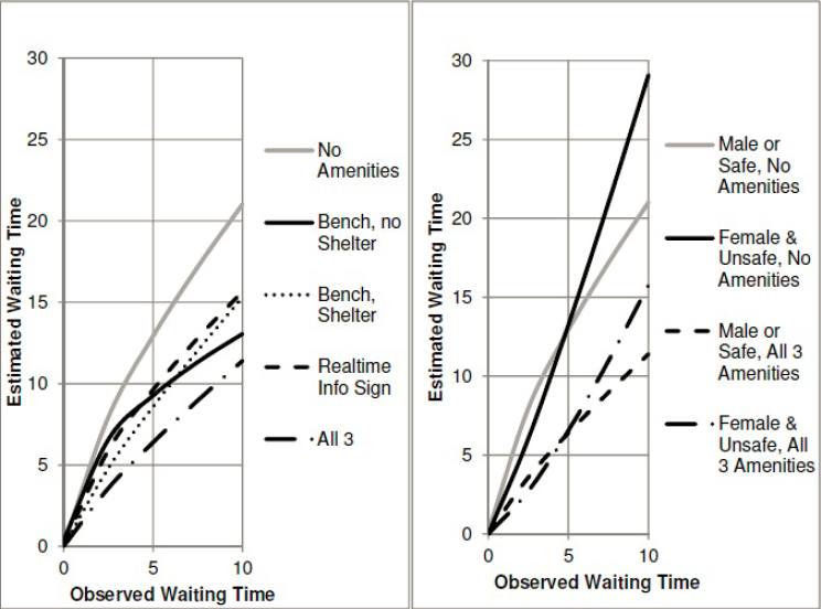
The gender breakdown comes from the fact that in unsafe neighborhoods, women perceive waits as even longer than the usual penalty, whereas in safe ones there is no difference between women and men.
The upshot is that if the wait time is 10 minutes, then passengers at a stop with a bench and shelter perceive the wait as 15 minutes, and if there’s also real-time information then this shrinks to 11 minutes. If there are no amenities, then passengers perceive a 15-minute wait when they’ve waited just 6.5 minutes and an 11-minute wait when they’ve waited just 4. In other words, to estimate the impact of shelter we can look at the impact of reducing waits from 10 minutes to 6.5, and if there’s also real-time info then it’s like reducing waits to 4 minutes.
If the wait is 5 minutes then the impact is similar. With bench and shelter the perceived wait is 8.5 minutes, equivalent to a 3-minute wait without any amenities; with real-time information, the perceived wait is 6.5 minutes, equivalent to a 2-minute wait without amenities. There is some scale-dependence, but not too much, so we can model the impact of shelter as equivalent to that of increasing frequency from every 10 minutes to every 6.5 minutes (without real-time displays) or every 4 minutes (with real-time displays).
I have some lit review of ridership-frequency elasticity here. On frequent buses it is about 0.4, but this is based on the assumption that frequency is 7.5-12 minutes, not 4-6 minutes. At the low end this is perhaps just 0.3, the lowest found in the literature I’ve seen. To avoid too much extrapolation, let’s take the elasticity to be 0.3. Fan-Guthrie-Levinson suggests shelter alone is equivalent to a 50-66% increase in frequency, say 60%; thus, it should raise ridership by 15%. With real-time info, make this increase 30%.
What I think of as the upper limit to acceptable cost of capital construction for rail is $40,000-50,000 per weekday rider; this is based on what makes activists in Paris groan and not on first principles. But we can try to derive an equivalent figure for buses. On the one hand, we should not accept such high costs for bus projects, since buses have higher operating expenses than rail. But this is not relevant to shelter, since it doesn’t increase bus expenses (which are mostly driver labor) and can fund its ongoing maintenance from ads. On the other hand, a $40,000/rider rail project costs somewhat more per new rider – there’s usually some cannibalization from buses and other trains.
But taking $40,000/rider as a given, it follows that a bus stop should be provided with shelter if it has at least ($15,000/$40,000)/0.15 = 2.5 weekday boardings. If the shelter installation includes real-time info then the denominator grows to 0.3 and the result falls to 1.25 weekday boardings.
In New York, there are 13,000 bus stops, so on average there are around 180 boardings per stop. Even in Rhode Island, where apparently the standard is that a bus stop gets shelter at 50 boardings (and thus there is very little shelter because apparently it’s more important to brand a downtown trunk as a frequent bus), there are 45,000 weekday riders and 3,000 stops, so at 15 riders per stop it should be fine too put up shelter everywhere.
The only type of stop where I can see an exception to this rule is alighting-only stops. If a route is only used in a peak direction, for example toward city center or away from city center, then the outbound stops may be consistently less used to the point of not justifying shelter. But even that notion is suspicious, as American cities with low transit usage tend to have weak centers and a lot of job and retail sprawl. It’s likely that a large majority of bus stops in Rhode Island and all stops within Providence proper pass the 2.5 boardings rule, and it’s almost guaranteed that all pass the 1.25 boardings rule. And that’s even before consolidating stops, which should be done to improve bus speed either way.
At least based on the estimates I’ve found, installing bus shelter everywhere is a low-hanging fruit in cities where this is not already done. In the situation of New York, this is equivalent to spending around $550 per new weekday rider on transit – maybe somewhat more if the busier stops already have shelter, but not too much more (and actually less if there’s stop consolidation, which there should be). Even in that of Providence, the spending is equivalent to about $6,600 per rider without stop consolidation, or maybe $3,000 with, which is much better than anything the state will be able to come up with through the usual channels of capital expansion.
If it’s not done, the only reason for it is that transit agencies just don’t care. They think of buses as a mode of transportation of last resort, with a punishing user experience. Cities, states, and transit agencies can to a large extent decide what they have money for, and letting people sit and not get drenched is just not a high priority, hence the “we don’t have money” excuse. The bosses don’t use the buses they’re managing and think of shelter as a luxury they can’t afford, never mind what published transportation research on this question says.
Battery-Electric Buses: New Flyer
Two months ago, after my article about battery-electric buses appeared in CityLab, New Flyer reached out to me for an interview. Already in one of the interviews I’d done for the article, I heard second-hand that New Flyer was more reasonable than Proterra and BYD and was aware of the problem of battery drain in cold weather. I spoke to the company’s director of sustainable transportation, the mechanical engineer David Warren, and this confirmed what I’d been told.
Most incredibly, I learned at the interview that the headline figures used in the US for electric bus performance explicitly exclude heating needs. The tests are done at the Altoona site and only look at electricity consumption for propulsion, not heating. New Flyer says that it is aware of this issue and has tried not to overpromise, but evidently Proterra and BYD both overpromise, and regardless of what any vendor says, American cities have bought into the hype. In Duluth this was only resolved with fuel-fired heaters; the buses only use electricity for propulsion, which is not the majority of their energy consumption in winter.
Warren and I discussed New York specifically, as it has a trial there on the M42. The heater there puts out 22 kW of energy at the peak, but on the day we discussed, January 29th, when the air temperature was about -7*, actual consumption was on average about 10 kW. Electricity consumption split as 40% heating, 20% propulsion, and 40% other things, such as the kneeling system for easier boarding.
The battery can last many roundtrips on the M42, specifically a very slow route. Electric vehicles tend to do much better then fuel-powered ones at low speed in city traffic, because of regenerative braking and higher efficiency. When I discussed the Proterra trial with MVTA, I was told specifically that the buses did really well on days when the temperature was above freezing, since the battery barely drained while the bus was sitting in rush hour Downtown Minneapolis traffic. This pattern is really a more extreme version of one that may be familiar to people who have compared fuel economy ratings for hybrid and conventional cars: hybrids are more fuel-efficient in city driving than on the highway, the opposite of a non-hybrid, because their electric acceleration and deceleration cycles allow them some of that regeneration.
The current system is called OppCharge (“opportunity charging”), and currently requires the bus to spend 6 minutes out of every hour idling for recharge; the Xcelsior presentation shows a bus with a raised pantograph at a charging station, and I wonder whether it can be extended to an appropriate length of wire to enable in-motion charging.
The New Flyer examples I have seen are in large cities – New York and Vancouver. New York’s system for opportunity charging does not require an attendant; Vancouver’s may or may not, but either way the charging is at a bus depot, where the logistics are simpler. In contrast, in Albuquerque the need for midday charging was a deal breaker. When I talked to someone who knew the situation of Albuquerque’s BRT line, ART, I was told that the BYD midday charge system would require an attendant as well as room for a charging depot. Perhaps an alternative system could get rid of the attendant, but the land for a bus that at the end of the day isn’t that busy has nontrivial cost even in Albuquerque.
Even with opportunity charging, batteries remain hefty. Warren said that they weigh nearly 4 tons per standard-length bus; the XE40 weighs 14 metric tons, compared with 11.3 for the older diesel XD40 platform. Specifically on a short, high-ridership density like the M42 and many other New York buses, there is likely to be a case for installing trolleywire and using in-motion charging. In-motion charging doesn’t work well with grids, since it is ideally suited to when several branches interline to a long trunk route that can be electrified, but ultimately it’s a bus network with ridership density comparable to that of some big American light rail networks like Portland’s.
*In case it’s unclear to irregular readers, I exclusively use metric units unless I mention otherwise, so this is -7 Celsius and not -7 Fahrenheit; the latter temperature would presumably drain the battery a lot faster.
Park-and-Rides (Hoisted from Comments)
My post about the boundary zone between the transit-oriented city and its auto-oriented suburbs led to a lot of interesting discussions in comments, including my favorite thing to hear: “what you said describes my city too.” The city in question is Philadelphia, and the commenter, Charles Krueger, asked specifically about park-and-ride commuter rail stations. My post had mentioned Southeast on the Harlem Line as an interface between commuter rail and the Westchester motorway network, and the natural followup question is whether this is true in general.
The answer is that it’s complicated, because like the general concept of the cars/transit boundary zone, park-and-rides have to be rare enough. If they’re too common, the entire rail system is oriented around them and is not really a boundary but just an extension of the road network. This is the situation on every American commuter rail system today – even lines that mostly serve traditional town centers, like the New Haven Line, focus more on having a lot of parking at the station and less on transit-oriented development. Even some suburban rapid transit lines, such as the Washington Metro, BART, and the recent Boston subway extensions, overuse park-and-rides.
However, that American suburban rail systems overuse such stations does not mean that such stations must never be built. There are appropriate locations for them, provided they are used in moderation. Those locations should be near major highways, in suburbs where there is a wide swath of low-density housing located too far from the rail line for biking, and ideally close to a major urban station for maximum efficiency. The point is to use suburban rail to extend the transit city outward rather than the auto-oriented suburban zone inward, so the bulk of the system should not be car-oriented, but at specific points park-and-rides are acceptable, to catch drivers in suburbs that can’t otherwise be served or redeveloped.
Peakiness and park-and-rides
I’ve harped on the importance of off-peak service. The expensive part of rail service is fixed costs, including the infrastructure and rolling stock; even crew labor has higher marginal costs at the peak than off-peak, since a high peak-to-base ratio requires split shifts. This means that it’s best to design rail services that can get ridership at all times of day and in both directions.
The need for design that stimulates off-peak service involves supportive service, development, and infrastructure. Of these, service is the easiest: there should be bidirectional clockface schedule, ideally with as little variation between peak and off-peak as is practical. Development is politically harder, but thankfully in the main example case, the Northeastern United States, commuter rail agencies already have zoning preemption powers and can therefore redevelop parking lots as high-intensity residential and commercial buildings with walkable retail.
Infrastructure is the most subtle aspect of design for all-day service. Park-and-ride infrastructure tends to be peaky. Whereas the (peakier, more suburban) SNCF-run RER and Transilien lines have about 46% of their suburban boardings at rush hour, the LIRR has 67%, Metro-North 69%, and the MBTA 79%. My linked post explains this difference as coming from a combination of better off-peak service on the RER and more walkable development, but we can compare these two situations with the Washington Metro, where development is mostly low-density suburban but off-peak frequency is not terrible for regional rail. Per data from October 2014, this proportion is 56%, about midway between Transilien and the LIRR.
This goes beyond parking. For one, railyards should be sited at suburban ends of lines, where land is cheap, rather than in city center, where land is expensive and there is no need to park trains midday if they keep circulating. But this is mostly about what to put next to the train stations: walkable development generating a habit of riding transit all day, and not parking lots.
Where parking is nonetheless useful
In response to Charles’ comment, I named a few cases of park-and-rides that I think work well around New York, focusing on North White Plains and Jersey Avenue. There, the parking-oriented layout is defensible, on the following grounds:
- They are located in suburban sections where the reach of the highway network is considerable, as there is a large blob of low density, without much of the structure created by a single commuter line.
- They are near freeways, rather than arterials where timed connecting buses are plausible.
- They are immediately behind major stations in town centers with bidirectional service, namely White Plains and New Brunswick, respectively.
The importance of proximity is partly about TOD potential and partly about train operating efficiency. If the park-and-rides are well beyond the outer end of bidirectional demand, then the trains serving them will be inefficient, as they will get relatively few off-peak riders. A situation like that of Ronkonkoma, which is located just beyond low-ridership, low-intensity suburbs and tens of kilometers beyond Hicksville, encourages inefficient development. Thus, they should ideally be just beyond the outer end, or anywhere between the city and the outer end.
However, if they are far from the outer end, then they become attractive TOD locations. For example, every station between New York and White Plains is a potential TOD site. It’s only near White Plains that the desirability of TOD diminishes, as White Plains itself makes for a better site.
On rapid transit in American suburbia, one example of this principle is the Quincy Adams garage on the Red Line just outside Boston. While the station itself can and should be made pedestrian-friendlier, for one by reopening a gate from the station to a nearby residential neighborhood, there’s no denying the main access to the station will remain by car. Any TOD efforts in the area are better spent on Quincy Center and Braintree, which also have commuter rail service.
Where parking should urgently be replaced by TOD
American suburban rail lines overuse park-and-rides, but there are specific sites where this type of development is especially bad. Often these are very large park-and-ride structures built in the postwar era for the explicit purpose of encouraging suburban drivers to use mainline rail for commuter and intercity trips. With our modern knowledge of the importance of all-day demand, we can see that this thinking is wrong for regional trips – it encourages people to take rail where it is the most expensive to provide and discourages ridership where it is free revenue.
The most important mistake is Metropark. The station looks well-developed from the train, but this is parking structures, not TOD. Worse, the area is located in the biggest edge city in the Northeast, possibly in the United States, possibly in the world. Middlesex County has 393,000 jobs and 367,000 employed residents, and moreover these jobs are often high-end, so that what the Bureau of Economic Analysis calls adjustment for residence, that is total money earned by county residents minus total money earned in the county, is negative (Manhattan has by far the largest negative adjustment in the US, while the outer boroughs have the largest positive one). The immediate area around Metropark and Woodbridge has 46,000 jobs, including some frustratingly close to the station and yet not oriented toward it; it’s a huge missed opportunity for commercial TOD.
In general, edge cities and edgeless cities should be prime locations for sprawl repair and TOD whenever a suburban rail line passes nearby. Tysons, Virginia is currently undertaking this process, using the Silver Line extension of the Metro. However, preexisting lines do not do so: Newton is not making an effort at TOD on the existing Green Line infrastructure, it’s only considering doing so in a part of town to be served by a potential branch toward Needham; and the less said about commuter rail, the better. Mineola and Garden City on Long Island, Tarrytown in Westchester, and every MBTA station intersecting Route 128 are prime locations for redevelopment.
Commuter rail for whomst?
I believe it’s Ant6n who first came up with the distinction between commuter rail extending the transit city into the suburbs and commuter rail extending the suburbs into the city. If the trains are frequent and the stations well-developed, then people from the city can use them for trips into suburbia without a car, and their world becomes larger. If they are not, then they merely exist to ferry suburban drivers into city center at rush hour, the one use case that cars are absolutely infeasible for, and they hem car-less city residents while extending the world of motorists.
Park-and-rides do have a role to play, in moderation. Small parking lots at many stations are acceptable, provided the station itself faces retail, housing, and offices. Larger parking structures are acceptable in a handful of specific circumstances where there is genuinely no alternative to driving, even if the rest of the rail service interfaces with walkable town centers. What is not acceptable is having little development except parking at the majority of suburban train stations.
30-30-30 is Feasible
This piece first appeared as a study attached to an article in the Connecticut Mirror by SE Coast’s Gregory Stroud.
Fresh off the election, Connecticut Governor Ned Lamont has proposed an ambitious infrastructure plan, dubbed 30-30-30, in which train travel between New York and Stamford, Stamford and New Haven, and New Haven and Hartford would be cut to 30 minutes. With an average speed of about 110 km/h, this is only about half the average speed typical of high-speed rail, but still slightly higher than that of the Northeast Regional between New York and Washington, which is competitive with cars and buses provided there is enough capacity.
For 30-30-30 to truly be cost-effective, the plan needs to speed up trains with relatively little infrastructure investment, at a cost measured in hundreds of millions of dollars. Is that feasible? The topline answer is yes. All three segments can be done in the specified amount of time. North of New Haven, there are generous margins, but 30-minute travel times will rely on electrifying the Shuttle and running high-quality electric trains. South of New Haven, each segment has just seconds to spare to achieve the governor’s goal, and no big-ticket capital investment would be needed, but the plan will require a complete overhaul in Metro-North operations.
Some additional repairs are needed on tracks straight enough to allow trains to run at 160 km/h, which are today only maintained to allow 75 mph, or 120 km/h. The state may also need to procure lighter trains, able to accelerate faster than the current equipment. On a fast schedule, with few intermediate stops, the difference with the current M8 trains is small, but in practice north of Stamford, where trains are likely to make many stops, the difference would be noticeable.
Most of all, reliability must improve enough that is possible to remove the extensive schedule padding in the timetable today. Metro-North is in a perpetual maintenance cycle. At any time there is a slow zone somewhere on the tracks, with generous schedule padding on top of it. Maintenance must be switched to the nighttime, as is practiced on high-speed lines in Japan and France and on subways everywhere in the world outside New York, in order to improve daytime reliability.
The simulation of train performance
In order to figure out the best possible trip times, I made a table of speed zones on the New Haven Line, from Grand Central to New Haven. But instead of using current speed zones, which are very conservative, I looked for the maximum speed that is feasible within the current right-of-way.
The most important rule I followed is no curve modifications, even modifications that are likely to happen under any high-speed rail scenario. While some capital investment may still be required, it is entirely within existing rights-of-way.
In the simulation, I used code outputting slow penalties for trains based on prescribed performance characteristics. For this, I used two sets of characteristics. The first, is for the M8 trains used by Metro-North today. The second is an average of modern European regional trains, such as the Stadler FLIRT, the Alstom Coradia, the Bombardier Talent 2, the CAF Civity, and the Siemens Mireo. Because they are much lighter-weight, all have about 50% better acceleration than the M8 at any speed. Both sets of trains can reach the same top speed, 160 km/h, but when the M8 slows down from top speed to make a station stop, the extra acceleration and deceleration time add another 69 seconds to the trip, compared with only 46 seconds on the European regional trains.
That said, the proposed schedule has few intermediate stops, and even with frequent slowdowns due to curves, the total difference in time between the two sets of trains is about two minutes. So, while I would urge Connecticut to buy modern trains at its next procurement, based on the latest revision in FRA regulations permitting lightly-modified European trains, the present-day rolling stock is good enough, it’s just much heavier than it needs to be.
While I did not assume any curve modifications, I did assume that trains could run faster on curves than they do today. The New Haven Line has conservative values for the permitted centrifugal force acting on trains. I explain more about this in a previous post about trains in Connecticut, but the relevant figures are about 8” of total equivalent cant on the New Haven Line today, or about 200 mm, whereas light trackwork increasing total cant and already-existing regulatory changes above the rails could raise this to 12” on existing trains, about 300 mm, and even more on tilting trains like the Acela. The difference between 200 and 300 mm of total equivalent cant corresponds to a 22% increase in speed; the formula is 
Moreover, in some areas the maximum speeds are even lower than one might assume based on curve radius and current permitted curve speeds. These include the movable bridges over the waterways, which have very low speed limits even when the tracks are mostly straight; if the bridges physically cannot accommodate faster trains then they should be replaced, a capital investment already on the state and the region’s official wishlist.
In addition to speed limits imposed by curves and bridges, there is a uniform speed limit of 90 mph (145 km/h) on the New York segment of the line and 75 mph on the Connecticut segment. This is entirely a matter of poor maintenance: the right-of-way geometry could support higher speed today in some places, even without curve modifications.
Finally, trains today go at excruciatingly slow speed in the throat heading into the bumper tracks at Grand Central, 10 miles per hour. This is bad practice: even with bumper tracks, German train throats with complex switches are capable of 70 km/h. This change alone would save about 4 minutes. Overall, trains today are scheduled to take about 11-12 minutes between Grand Central and Harlem, and the proposed schedule cuts this down to 5-6.
The proposed schedule
I am attaching a spreadsheet with exact speed zones, rounded down in 5 km/h increments. People who wish to see what’s behind the timetable I’m proposing can go look there for intermediate times. These may be especially useful to people who want to see what happens if more stops on the Lower New Haven Line are included. For example, one might notice that all technical travel times are padded 7%, as is standard practice in Switzerland, and that trains dwell exactly 30 seconds at each station, which is observed on busy commuter lines in Zurich as well as Paris.
I am including two stopping patterns: regional and intercity. Regional trains make the same stops as the Upper New Haven Line trains do today, plus New Rochelle. Intercity trains only make a few stops beyond Stamford, with a stopping pattern close to that of Amtrak. In addition, I am including two different sets of rolling stock: the current M8, and lighter, faster-accelerating European trainsets. The difference in the regional train pattern is noticeable, while that in the intercity one is less so.
Finally, at stations, it’s possible to state the scheduled the time the train arrives at the station or the one it departs. At all intermediate stations, the timetable below states the arrival time, unlike the attached spreadsheet, which uses departure times to permit calculating exact average speeds.
| Stop | Regional, M8 | Regional, euro | Intercity, M8 | Intercity, euro |
| Grand Central | 0:00 | 0:00 | 0:00 | 0:00 |
| Harlem-125th | 0:05 | 0:05 | 0:05 | 0:05 |
| New Rochelle | 0:17 | 0:16 | 0:17 | 0:16 |
| Stamford | 0:30 | 0:29 | 0:30 | 0:29 |
| Noroton Heights | 0:34 | 0:33 | ||
| Darien | 0:37 | 0:35 | ||
| Rowayton | 0:39 | 0:37 | ||
| South Norwalk | 0:42 | 0:40 | 0:37 | 0:36 |
| East Norwalk | 0:45 | 0:42 | ||
| Westport | 0:48 | 0:45 | ||
| Greens Farms | 0:52 | 0:48 | ||
| Southport | 0:55 | 0:51 | ||
| Fairfield | 0:57 | 0:53 | ||
| Fairfield Metro | 1:00 | 0:56 | ||
| Bridgeport | 1:04 | 0:59 | 0:49 | 0:47 |
| Stratford | 1:09 | 1:03 | ||
| Milford | 1:13 | 1:07 | ||
| West Haven | 1:19 | 1:13 | ||
| New Haven | 1:23 | 1:17 | 1:03 | 1:01 |
New Haven-Hartford-Springfield
In theory, achieving the governor’s proposed timetable is easier north of New Haven. The Hartford Line is a straight route. Most of it has a top speed of 80 mph, and outside the approaches to New Haven and Hartford, the speed restrictions are caused by arbitrarily slowdowns for grade crossings rather than by constrained geometry.
However, in practice, the line is in poor state of repair. Grade crossings are unprotected. The entire line is not electrified, and there are no plans to electrify it, for reasons that can only be explained as an allergy that North American railroaders have to electrification. The stations have low platforms, which are not accessible to people in wheelchairs without labor-intensive, time-consuming lift operations—and even if there are no riders with disabilities, it just takes longer for passengers to board from low platforms.
The above schedule assumes 7% padding and 30-second dwell times at stations, but such assumptions only work when the equipment is reliable, and when there are wide doors letting passengers on the train with level boarding or at worst short steps. Traditional commuter lines pulled by diesel locomotives, serving low-platform stations with narrow doors, have to be much slower. Clem Tillier‘s example timetable for Caltrain requires 15% padding and 45-second dwell times with today’s diesel operations—and at rush hour some station dwells stretch over minutes due to the railroad’s uniquely high number of passengers with bicycles.
The good news is that electrification and high platforms are, in the grand scheme of things, cheap. Amtrak electrified the Northeast Corridor between New Haven and Boston at $3.5 million per kilometer in the 1990s, adjusted for inflation; at that cost, wiring the entire New Haven-Springfield shuttle would run up to $350 million. Moreover, Boston has been equipping a number of commuter rail stations with high platforms in order to provide wheelchair accessibility, and in ordinary circumstances, the costs have been on the order of $6-10 million per station. This entire package on the Hartford Line would be cheaper than replacing any of the movable bridges on the New Haven Line.
Moreover, upgrading grade crossings with four-quadrant gates, which make it impossible for cars to drive around the gates while they are closed, is affordable as well—and would permit the towns along the route to institute quiet zones, eliminating the loud train horns. In Boulder, the same installation costs about $500,000 per grade crossing for quad gates and another $300,000 for an alternative to horns; in federal regulations, quad gates are good up to 110 mph. There are 23 level crossings between New Haven and Hartford and another 11 between Hartford and Springfield; $30 million would upgrade them all.
The importance of a good maintenance regime
In Switzerland, schedules are padded by 7% over the technical travel time, to permit trains to recover from delays. By American standards, this is a low figure: the LIRR’s schedules are padded by 20-30%, and I have personally seen an express New Haven Line train do Stamford-Grand Central in about 15% less than the scheduled trip time.
Switzerland achieves high punctuality with relatively tight scheduling by making sure delays do not propagate. Railroad junctions are grade-separated when possible, and if not then they are equipped with pocket tracks to allow trains to wait without delaying crossing traffic. To achieve comparable reliability, Metro-North should grade-separate its most important junctions: Shell, where the line joins with the Northeast Corridor tracks carrying Amtrak (and soon Penn Station Access); and Stam, where the New Canaan Branch joins. It could potentially also grade-separate Berk, where the Danbury Branch joins, and Devon, where the Waterbury Branch joins, but the traffic at these junctions is lighter and delayed branch trains can wait without disturbing mainline trains.
Moreover, like the rest of Europe as well as Japan, Switzerland conducts maintenance at night. The daytime maintenance with work zones that are a common sight on American passenger railroads are unknown on most European railroads. Only mixed lines running high-speed passenger trains in the day and freight at night have to schedule trains next to active work zones, and those are indeed much harder to maintain.
The laws of physics are the same on both sides of the Atlantic. If it’s possible to maintain tracks adequately during four-hour nighttime windows in Europe, it’s possible to do the same in the United States. Freight traffic on the Northeast Corridor is lighter than on many Swiss mainlines, and while passenger traffic at rush hour is very heavy, in the off-peak it is considerably lighter than on the urban commuter rail line trunks of Zurich. While four Metro-North trains run between New York and Stamford every off-peak hour, as does a single Amtrak train, ten Zurich S-Bahn trains run per hour between Zurich and Winterthur, as do six interregional and intercity trains.
The importance of maintenance was underscored in a recent article describing an independent plan to drastically cut travel times through better track standards, spearheaded by Joe McGee of the Business Council of Fairfield County and authored by San Francisco consultant Ty Lin and former Metro-North president Joseph Giulietti. In response to their plan, CDOT said it was not possible—and to emphasize this fact, the article notes that an upcoming schedule revision will slow down the trains by 6 to 10 minutes due to trackwork delays.
The one thing that the state must avoid is funneling any money into State of Good Repair (SOGR) programs. SOGR is a black hole permitting incompetent officials to spend capital money without anything to show for it: agencies around the country have SOGR programs decade after decade and somehow their stated maintenance backlogs never shrink.
Instead, 30-30-30 is the closest thing to a true program for what SOGR is supposed to be. Were the tracks in good shape, and were speeds on curves in line with modern railroading practices in other developed countries, express trains would take exactly half an hour to travel between Grand Central and Stamford and between Stamford and New Haven. So 30-30-30 is really setting a standard for a program that, up until now, has only served as an excuse for CDOT to do nothing.
It’s not yet clear what CDOT and Metro-North’s reaction to 30-30-30 will be. Is the governor’s goal achievable? Absolutely, give or take a few minutes. Is it achievable on a reasonable budget? Definitely. Are the managers who have let train schedules slip over the years, as their counterparts in New York have, capable of running the trains punctually enough in order to meet the timetable? That is the big question mark.
The British Way of Building Rapid Transit
By a more than 2-1 vote among my Patreon backers, the third installment in my series about national traditions of building urban rail is the British one, following the American and Soviet ones. While rapid transit in Britain outside London is even smaller than in the US outside New York, the British tradition is influential globally for two reasons: first, Britain invented the railway as well as urban rapid transit, and second, Britain had a vast empire much of which still looks up to it as a cultural and scientific metropole.
Nonetheless, despite the fact that all rapid transit traditions technically descend from London’s, it is worthwhile talking about the British way. What London built inspired and continues to inspire other cities, but many, mainly in the United States, Japan, and Continental Europe, diverged early, forming distinct tradition. As I noted in the post about the Soviet bloc, Moscow was heavily influenced by British engineering, and its own tradition has evolved separately but began as a more orderly way of reproducing the London Underground’s structure in the 1930s.
In taxonomy, this is called a paraphyletic group. Monophyly means a taxon descending from a single ancestor, for example mammals; paraphyly means a taxon descending from a single ancestor excluding certain monophyletic subgroups, for example reptiles, which exclude mammals and birds, both of which descend from the same common ancestor.
The invention of rapid transit
Like most other things Britain became known for, like constitutional government and colonialism, rapid transit evolved gradually in London. Technically, the first railway in London, 1836’s London and Greenwich, meets the definition of urban rapid transit, as trains made some local stops, ran every 20 minutes, and were grade-separated, running on brick arches. However, it is at best an ancestor of what we think of as rapid transit, since it lacked the really frequent stops of the Underground or the New York els.
The first proper rapid transit line in London, the Metropolitan line, opened in 1863. It, too, lacked some features that are standard on nearly all rapid transit systems today: most importantly, it was not self-contained, but rather had some through-service with intercity rail, and was even built dual-gauge to allow through-service with the Great Western Railway, which at the time had broad gauge. Trains ran every 10 minutes, using steam locomotives; to limit the extent of smoke in the tunnels, the line was not fully underground but had a long trench between King’s Cross and Farringdon.
The Met line and the second Underground line, 1868’s District line, were both built cut-and-cover. However, whereas Met line construction went smoothly, the District line had to carve a right-of-way, as the city did not have adequate wide streets for serving the proposed route. The areas served, Kensington and Chelsea, were even then a tony neighborhood with expensive real estate, and the construction costs exploded due to land acquisition. In today’s terms the Met line cost about $32 million per kilometer and the District $90 million, a record that among the historical lines I know of remained unbroken until New York built the Independent Subway System in the 1930s.
The Met and District met to form a circle, and in general, London loved building circular lines. In addition to what would be called the Circle line until a revision last decade, there were two circles farther out, called the Middle Circle and Outer Circle. These were run by mainline railroads; there was still no legal distinction between the two urban railroads and the mainlines, and through-service and even some freight service continued on the Met well into the 20th century, which the company used as an excuse to delay its merger with the other Underground companies.
Even electric rapid transit took time to take shape. After the bad experience with the District line, there was no more cut-and-cover in Central London. The next line to open, 1890’s Northern line, required the invention of deep boring and electric traction; it was not the first rail line to use electricity, but was the first excluding streetcars. However, while the line looked like a normal self-contained rapid transit line, it was pulled by electric locomotives; electric multiple units only came a few years later, starting haphazardly in Liverpool in 1893 (each car required separate controls) and in the more conventional way on the Chicago L in 1897.
Spontaneous order and radial network design
Among the inventions that came out of London was the radial network design. Unlike the physical inventions like underground rail and electric traction, this was not a deliberate choice. It evolved through spontaneous order, owing to the privately-funded nature of British railways. A British railway had to obtain the approval of Parliament to begin construction, which approval would also permit compulsory purchase of land along the way, but funding was entirely private. An early proposal for an underground railway, an 1860s route running what would later become the Charing Cross branch of the Northern line, was approved but could not secure funding and thus was not built.
The upshot is that with private planning, only the strongest lines were built. The strongest travel demand was to the center of London, and thus the lines were all radial, serving either the City of London or the West End. There was no circumferential service. While there were many circles and loops, these were conceived as reverse-branches allowing some railroads to access multiple Central London terminals, or as ways to join two radials like the Met and District without having to go through the difficult process of turning a train underground in a world in which all trains had to be pulled by locomotives.
The same preponderance of radial lines can be seen in other privately-planned contexts. Today, the best-known example is the matatu network of Nairobi. It is informal transit, but has been painstakingly mapped by urbanists, and the network is entirely radial, with all lines serving city center, where the jobs requiring commuting are.
Despite the private planning, London has only a handful of missed connections between lines: it has eight, but only one, between the Met line and the Charing Cross branch of the Northern line, is a true miss between two lines – the other seven are between parallel outer branches or between two lines that intersect a few times in close succession but only have one transfer (namely, the Bakerloo and Met). This is not because private planners build connections spontaneously – Parliament occasionally demanded some minor route changes, including interchange stations at intersections.
The role of regional rail
Like rapid transit, regional rail evolved in London in a haphazard fashion. The London and Greenwich was a mainline railway and the Met line had some mainline through-service, and even the deep-level tube lines are compatible enough with mainline rail that there is some track-sharing, namely between the Bakerloo line and the Watford DC line. The trench between King’s Cross and Farringon was widened to four tracks and turned into a north-south through-route in the 1870s but then abandoned in the 1920s and only reactivated in the 1980s as Thameslink.
The upshot is that London ended with the bones of a regional rail network but no actual service. The ideal was self-contained Underground lines, so even when connections suggested themselves they were not pursued. For example, the original proposal for an underground line between Euston and Charing Cross involved some through-service to the railways at both ends, but when the line was finally built as the Charing Cross branch of the Northern line it was not connected to the mainline and only took over minor branches in suburban North London.
While British planners did eventually plan for through-service – plans for Crossrail date to World War Two or just afterward – by then London was not innovating but rather imitating. By the war, Berlin had already had two S-Bahn through-lines, Munich was planning one, and Tokyo had three. The modern design for Crossrail is best compared with the RER A, in a city London has treated as its primary competitor for a long time now.
Exporting London’s network design
Moscow was heavily influenced by London early on. Later on, Singapore and Hong Kong both drew on British engineering expertise. London’s status as the first city to build rapid transit may have influenced Moscow, but by the 1920s New York had surpassed it in city size as well as urban rail ridership. Moscow’s drawing on London was as I understand it accidental – the chief engineer happened to have London connections – but in Singapore, Hong Kong, Australia, and so on the relationship is colonial, with extensive cultural cringe.
In all of these non-British cities, the British design as exported was cleaner. What I mean is, the systems have a radial structure like London, but the radii are cleaner in that two lines will generally cross just once, especially in Moscow; it’s not like London, where the Central line is always north of the District line, meeting once in a tangent at Bank and Monument, or where the Victoria line and Northern line cross twice.
Another cleaner aspect is the transfer experience. Singapore and Hong Kong both make extensive use of cross-platform transfers between otherwise perpendicular lines; London only does sporadically, on the Victoria line.
A third aspect is uniformly wide interstations. London’s average interstation is about 1.25 km, which is what I think of as the standard because it is very close to the average in Tokyo and Mexico City as well, and at the time I started tracking this statistic in the late 2000s, the Chinese systems were still small. Moscow’s average is 1.7 km, and Singapore’s is similar. Hong Kong is actually divergent there: the MTR mixes core urban lines averaging about the same as in London with the more widely-spaced historically mainline East and West Rail lines and the airport express.
The relative paucity of circumferential rail is hard to judge in the export cases. Moscow came up with the idea for the Circle Line natively; there is an urban legend that it was accidentally invented by Stalin when he left a coffee cup on the map and it stained it in the shape of a circle. Hong Kong doesn’t have much circumferential rail, but its geography is uniquely bad for such service, even more so than New York’s. Singapore does have a Circle Line, but it’s one of the two worst-designed parts of the MRT, with a reverse-branch (the other one is the self-intersecting, connection-missing Downtown Line).
At the same time, it’s worth viewing which aspects British-influenced systems are getting rid of when designing cleaner version of the Underground. The most important is regional rail. Singapore has none: it has a legacy narrow-gauge rail line to Malaysia, but has never made an effort to take control of it and develop it as an urban regional rail line.
Another negative aspect exported by London is the preponderance of deep boring. I made the same complaint when discussing the Soviet bloc: while London is poor in wide arterials that a cut-and-cover subway could go underneath, Moscow is rich in them, and the same is true of Singapore.
Does this work?
London invented rapid transit as we know it, but it did so gradually and with many seams. In some sense, asking if this works is like asking if rapid transit as a technology works, for which the answer is that it is a resounding success. But when it comes to the details, it’s often the case that London has accidental successes as well as accidental mistakes.
In particular, the fact that London almost invented regional rail is a source of endless frustration and extensive retro-crayon. The Met line is almost a 19th-century Crossrail, the Widened Lines are almost a 19th-century Thameslink, and so on. Instead, as time went on the trend has been toward more self-contained lines, which is good for reliability but not when there are self-contained slow tracks of mainlines to hook into, as is planned for Crossrail and as has sporadically been the case for the Watford DC line.
The British focus on radial systems has generally been good. To the extent London has underused metro lines, it’s not because they are poorly-routed as some of the lines in Paris are, but because they serve areas that have many urban rail lines and not a lot of population density; London is not a dense city, going back to the Victorian era, when it standardized on the rowhouse as the respectable urban housing form rather than the mid-rise apartment of Continental Europe or New York.
To the credit of British-influenced planning, Singapore has managed to fit a circumferential line into its system with good connections, just with an awkward reverse-branch. London’s own circumferential transit, that is the Overground, misses a large number of Underground connections due to its separate origin in freight bypasses and mainline rail reverse-branches, where Parliament saw no point in requiring interchange stations the way it did on the Tube. However, the cleaner version seen in Singapore only misses connections involving the Downtown Line, not the Circle Line.
What is perhaps the worst problem with the British style of design is the construction cost. The Northern line was not expensive – in today’s terms it cost around $35 million per km, give or take. However, after WW2 a gap opened between the cost of cut-and-cover and bored metros. The Milan method for cut-and-cover built a subway for around $45 million per km a few years before London bored the Victoria Line for $110 million. Britain exported its more expensive method, which must be treated as one factor behind high construction costs in Singapore, Hong Kong, Australia, and New Zealand; in New Zealand the regional rail tunnel is expensive even as electrifying the system was not.
In the future, cities that wish to build urban rail would be wise to learn from the network design pioneered by London. Urban rail should serve city centers, with transfers – and as in the subsequent refinements of cities that adapted London’s methods to their own needs, there should be some circumferential transit as well. But if mainlines are available, it would be wise to use them and run trains through on the local tracks where available. Moreover, it would be unwise to conduct deep boring under wide streets; elevated or cut-and-cover construction is well-suited for such avenues, causing some street disruption but producing considerable less expensive lines.
Fix the Slowest Speed Zones
I am wrapping up a project to look at speedup possibilities for trains between New York and New Haven; I’ll post a full account soon, but the headline result is that express trains can get between Grand Central and New Haven in a little more than an hour on legacy track. In this calculation I looked at speed zones imposed by the curves on the line. The biggest possible speedups involve speed limits that are not geometric – and those in turn come from some very sharp slow zones. The worst is the Grand Central station throat, and I want to discuss that in particular since fixing the slowest zones usually yields the most benefits for train travel times.
Best practice for terminal approaches
Following Richard Mlynarik’s attempt to rescue the Downtown Extension in San Francisco, I’ve assumed that trains can approach terminals at 70 km/h, based on German standards. At this speed, an EMU on level track can stop in about 150 meters. In Paris, the excellent Carto Metro site details speed limits, and at most terminals with bumper tracks the speed limit is 60 km/h, with a few going up to 100 km/h.
Even with bumper tracks, 70 km/h can be supported, provided the train is not intended to stop right at the bumpers. At a fixed speed, the deceleration distance is the inverse of the deceleration rate. There is some variation in braking performance, but it’s in a fairly narrow range; on subway trains in New York, everything is supposed to brake at the same nominal rate of 3 mph/s, or 1.3 m/s^2, and when trains brake more slowly it’s because of a deliberate decision to avoid wearing the brakes out. As long as the train stops 1-2 car lengths away from the bumpers, as is routine on Metro-North, the variation will be much smaller than the margin of safety.
Fast movement through the station throat is critical for several reasons. First, as I’ll explain below, sharp speed limits have an outsize effect on trip times, and can be fixed without expensive curve easements or top-rate rolling stock. And second, at train stations with a limited number of tracks, the station throat is the real limiting factor to capacity, since trains would be moving in and out frequently, and if they move too slowly, they’ll conflict. With its 60 km/h throat, Saint-Lazare on the RER E turns 16 trains per hour at the peak on only four tracks.
American practice
I had a conversation with other members of TransitMatters in Boston yesterday, in which we discussed work to be done for our regional rail project. One of the other members, I forget who, asked me, do European train protection systems shut down in station throats too?
The answer to the question is so obviously yes that I wanted to understand why anyone would ask it. Apparently, the American mandate for automatic train protection on all passenger rail lines, under the name positive train control, or PTC, is only at speeds higher than 10 miles per hour. At 10 mph or less train operators can drive the train by sight, and no signaling is required, which is why occasionally trains overrun the bumpers even on PTC-equipped lines if the driver has sleep apnea.
Without video, nobody could see the facial expressions I was making. I believe my exact words were “…What? No! What? What the hell?”.
The conversation was about South Station, but the same situation occurs at Grand Central. Right-of-way geometry is good for decent station approach speed – there is practically no limit at Grand Central except tunnel clearances, which should be good for 100 km/h, and at South Station the sharp curve into the station from the west is still good for around 70 km/h given enough superelevation.
The impact of slow zones near stations
Last year, I published code for figuring out acceleration penalties based on prescribed train characteristics. The relevant parameters for Metro-North’s M8 is initial acceleration = 0.9 m/s^2, power/weight = 12 kW/t. Both of these figures are about two-thirds as high as what modern European EMUs are capable of, but it turns out that at low speed it does not matter too much.
Right now the Grand Central throat has a 10 mph speed limit starting just north of 59th Street, just south of milepoint 1. The total travel time over this stretch is 6 minutes, a familiar slog to every regular Metro-North rider; overall, the schedule between Grand Central and Harlem-125th Street is 10 minutes northbound and 12-13 minutes southbound, the difference coming from schedule padding. The remaining 65 or so blocks are taken at 60 mph, nearly 100 km/h, and take around 4 minutes.
Now, let’s eliminate the slow zone. Let trains keep cruising at 100 km/h until they hit the closer-in parts of the throat, say the last kilometer, where the interlocking grows in complexity and upgrading the switches may be difficult; in the last kilometer, let trains run at 70 km/h. The total travel time in the last mile now shrinks to a minute, and the total travel time between Grand Central and Harlem shrinks to 5 minutes and change. Passengers have gained 5 minutes based on literally the last mile.
For the same reason, the Baltimore and Potomac Tunnel imposes a serious speed limit – currently 30 mph through the tunnel, lasting about 2 miles; removing this limit would cut 2-2.5 minutes from the trip time, less than Grand Central’s 5 because the speed limit isn’t as wretched.
The total travel time between New York and New Haven on Metro-North today is about 1:50 off-peak, on trains making all stops north of Stamford. My proposed schedule has trains making the same stops plus New Rochelle doing the trip in 1:23. Out of the 27-28 minutes saved, 5 come from the Grand Central throat, the others coming from higher speed limits on the rest of the route as well as reduced schedule padding; lifting the blanket 75 mph speed limit in Connecticut is only worth about 3 minutes on a train making all stops north of Stamford, and even on an express train it’s only worth about 6 minutes over a 73 kilometer stretch.
What matters for high-speed travel
High-speed rail programs like to boast about their top speeds. But in reality, the difference between a vanilla 300 km/h train and a top of the line 360 km/h only adds up to a minute every 30 kilometers, exclusive of acceleration time. Increasing top speed is still worth it on lines with long stretches of full-speed travel, such as the Tohoku Shinkansen, where there are plans to run trains at 360 over hundreds of kilometers once the connection to Hokkaido reaches Sapporo. However, ultimately, all this extra spending on electricity and noise abatement only yields a second-order improvement to trip times.
In contrast, the slow segments offer tremendous opportunity if they are fixed. The 10 mph limit in the immediate Penn Station throat slows trains down by around 2 minutes, and those of Grand Central and South Station slow trains by more. A 130 km/h slog through suburbia where 200 km/h is possible costs a minute for every 6.2 km, which easily adds up to 5 minutes in a large city region like Tokyo. An individual switch that imposes an undue speed limit can meaningfully slow the schedule, which is why the HSR networks of the world invented high-speed turnouts.
Richard Mlynarik notes that in Germany, the fastest single end-to-end intercity rail line used to be Berlin-Hamburg, a legacy line limited to 230 km/h, where trains averaged about 190 km/h when Berlin Hauptbahnhof opened (they’ve since been slowed and now average 160). Trains go at full speed for the entire way between Berlin and Hamburg, whereas slow urban approaches reduce the average speed of nominally 300 km/h Frankfurt-Cologne to about 180, and numerous compromises reduce that of the nominally 300 km/h Berlin-Munich line to 160; even today, trains from Berlin to Hamburg are a hair faster than trains to Munich because the Berlin-Hamburg line’s speed is more consistent.
The same logic applies to all travel, and not just high-speed rail. The most important part of a regional railway to speed up is the slowest station throats, followed by slow urban approaches if they prove to be a problem. The most important part of a subway to speed up is individual slow zones at stations or sharp curves that are not properly superelevated. The most important part of a bus trip to speed up is the most congested city center segment.
The Rhine-Neckar Region
The weekend before last, I visited Kaiserslautern and Mainz; I have photos from Mainz and will blog about it separately later this week. Due to a train cancellation, my 2.5-hour direct train to Kaiserslautern was replaced with a three-leg itinerary via Karlsruhe and Neustadt that took 5.5 hours. Even though neither Kaiserslautern nor Karlsruhe is contained within the region, they are both served by the Rhine-Neckar regional rail network. After riding the trains I looked up the network, and want to explain how things work in a metro area that is not very well-known for how big it is.
How polycentric is the system?
The Rhine-Neckar is polycentric, but only to a limited extent. It does have a single central city in Mannheim, with 300,000 people, plus another 170,000 in Ludwigshafen, a suburb across the Rhine. With Heidelberg (which has 160,000 people) and many surrounding suburbs, the total population of this region is 2.5 million, about comparable to Stockholm, Copenhagen, and Hamburg.
The liminal polycentricity comes from the fact that Mannheim has a distinguished position that no single central city has in the Ruhr or Randstad. However, Heidelberg, Neustadt, Worms, and Speyer are all independent cities, all of which have long histories. It’s not like Paris, where the suburbs were all founded explicitly as new towns – Versailles in the Early Modern era, and the rest (Cergy, La Defense, Evry, Marne-la-Vallee, etc.) in the postwar era.
The rail network has the same liminal characteristic, which is what makes it so interesting. There is an S-Bahn, centered on Mannheim. There are two main trunk lines, S1/2 and S3/4: every numbered line runs on an hourly clockface schedule, and S2 and S4 provide short-turn overlays on the S1 and S3 lines respectively, giving half-hourly service on the combined lines. Some additional lines are not Mannheim-centered: the S33 is circumferential, and the S5/51 are two branches terminating at Heidelberg. Additional lines fanning out of Mannheim are under construction, to be transferred from the RegionalBahn system; already S6 to Mainz is running every half hour, and there are plans for lines going up to S9.
However, it is wrong to view the Rhine-Neckar regional rail network as a Mannheim-centric system the way the RER is Paris-centric and the Berlin S-Bahn is Berlin-centric. The Mannheim-centered S-Bahn lines run alongside a large slew of legacy RegionalBahn lines, which run on hourly clockface schedules. The S3 serves Karlsruhe and the S1 and S2 serve Kaiserslautern, but this is not how I got from Karlsruhe to Kaiserslautern: I took a regional train via Neustadt, running on a more direct route with fewer stops via Wörth and Landau, and transferred to the S1 at Neustadt.
Integrated timed transfers
Kaiserslautern is not really part of the Rhine-Neckar region. It is too far west. However, it is amply connected to the core of the region: it has S1 and S2 rail service (in fact it is the western terminus of the S2), and it has regional trains to Mannheim as well as to other cities within the region. The regional train from Mannheim to Kaiserslautern and points west is timed to leave Neustadt a few minutes ahead of the S1, as it runs on the same line but makes fewer stops.
In addition, all these trains to cities of varying levels of importance have a system of timed transfers. I took this photo while waiting for my delayed train back to Paris:
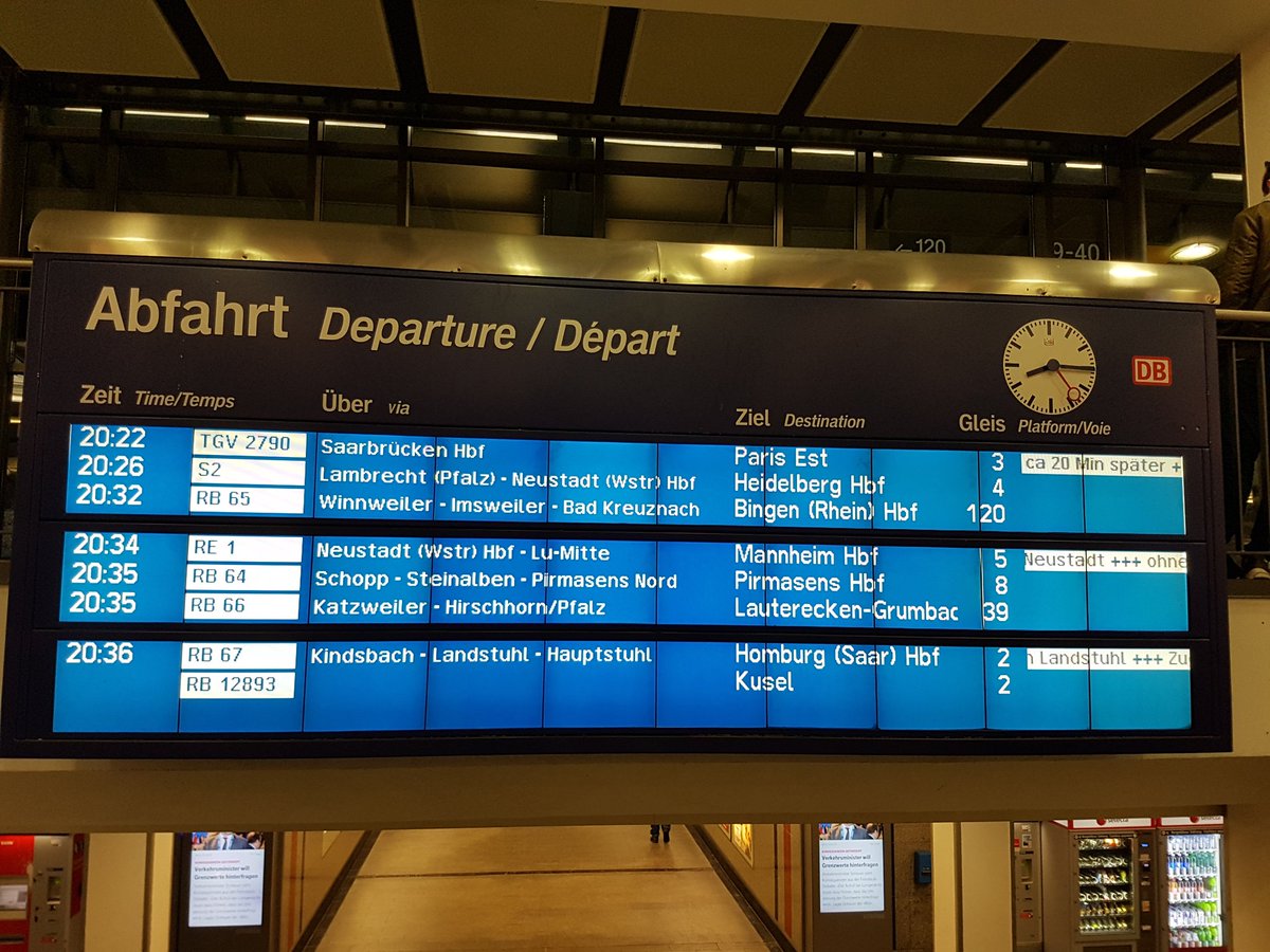
Other than the S-Bahn east, the trains all leave a few minutes after 8:30, and I saw them all arrive at the station just before 8:30, allowing passengers to interchange across as well as between platforms. Judging by static arrival boards posted at stations, this integrated timed transfer repeats hourly.
Some of the lines depicted on the map serve cities of reasonable size, including Mannheim and Heidelberg, but also Homburg, the western terminus of the S1. Others don’t; Pirmasens is a town of 40,000, and the intermediate towns on the line as it winds through the Palatinate valleys have a few thousand people each. Nonetheless, there is evidently enough demand to run service and participate in the integrated timed transfer plan.
Population density and the scope of the network
As I’ve mentioned above, neither Kaiserslautern nor Karlsruhe is properly part of the Rhine-Neckar. Neither is Mainz, which is within the Frankfurt region. Nonetheless, all are on the Rhine-Neckar S-Bahn, and Kaiserslautern isn’t even an outer terminus – it’s on the way to Homburg.
This is for two reasons. The first is that this is a new S-Bahn network, cobbled together from regional lines that were formally transferred to the S-Bahn for planning purposes. It lacks the features that bigger S-Bahn networks have, like strong urban service. The Rhine-Neckar is about the same size as Hamburg, where the S-Bahn provides 10-minute frequencies to a variety of urban neighborhoods; in contrast, the S1/2 and S3/4 trunk lines in Mannheim aren’t even set up to overlay to exact 15-minute frequencies on the shared segment to Heidelberg.
I’ve talked about the distinction between regional and intercity service in the context of Boston. In Boston I recommend that some lines be run primarily as intercities, with long-range service and fewer stops, such as the Providence and Lowell Lines, both serving independent urban centers with weak inner suburbs on the way, while others be run primarily as locals, with more urban stops, such as the Fairmount-Franklin Line, which has no strong outer anchor but does pass through dense neighborhoods and inner suburbs.
The same distinction can be seen in Germany, all falling under the S-Bahn rubric. Wikipedia has a map of all S-Bahn systems in Germany at once: it can be readily seen that Hamburg, Berlin, Munich, Stuttgart, and Frankfurt have predominantly local systems, while Hannover, Nuremberg, the Rhine-Neckar, and Middle Germany (where the largest city is Leipzig) have predominantly intercity systems that are run as if they were S-Bahns.
The second reason owes to the urban geography of the Rhineland. Paris, Berlin, and Hamburg are all clearly-defined city centers surrounded by rings of suburbs. The Rhineland instead has a variety of smaller urban centers, in which suburb formation often takes the form of people hopping to a nearby independent city and commuting from there. All of these cities have very small contiguous built-up areas relative to the size of their metropolitan regions, and contiguous suburbs like Ludwigshafen are the exception rather than the rule.
Moreover, the background population density in the Rhineland is very high, so the cities are spaced very close together. This enabled the Rhine-Ruhr to form as a polycentric metro area comparable in size to London and Paris without having any core even approaching the importance of Central London or central Paris. The Upper Rhine is not as industrialized as the Ruhr, but has the same interconnected network of cities, stretching from Frankfurt and Wiesbaden up to Karlsruhe. In such a region, it’s unavoidable that commuter lines serving different urban cores will touch, forcing an everywhere-to-everywhere network.
To reinforce the importance of high density, we can look at other areas of high population density. The Netherlands is one obvious example, underlying Randstad and an extremely dense national rail network in which it’s not really possible to separate different regions for planning purposes. England overall is dense as well, but the south is entirely London-centric; however, the same interconnected network of cities typical of the Middle and Upper Rhine exists in Northern England, which not only invented the railway but also maintains a fairly dense rail network and has a variety of connecting services like TransPennine. Finally, the Northeastern United States has commuter rail line on nearly the entire length of the Northeast Corridor, touching in Trenton between New York and Philadelphia, with perennial plans to extend services in Maryland, Connecticut, and Rhode Island to close the remaining gaps.
Swiss lessons
Switzerland has long had a national integrated transfer timetable, overlaying more local S-Bahn trains in the biggest cities. As long as there is more than one node in such a network, it is necessary to ensure travel times between nodes permit trains to make multiple transfers.
This leads to the Swiss slogan, run trains as fast as necessary, not as fast as possible. This means that, in a system based on hourly clockface schedules, the trip times between nodes should be about an hour minus a few minutes to allow for transfer time and schedule recovery. Potentially it’s possible to set up some intermediate nodes to have transfers at half-integer hours rather than integer hours, allowing half-integer hour timed transfers. Switzerland’s main intercity lines run on a half-hourly takt, with timed transfers on the hour every half hour in Zurich, Bern, and Basel, which are connected in a triangle with express trains taking about 53 minutes per leg; additionally, some smaller cities have timed transfers 15 and 45 minutes after the hour.
Germany’s rail network is less modern than Switzerland’s, and the Rhine-Neckar schedule shows it. S-Bahn trains run between Kaiserslautern and Mannheim in a few minutes more than an hour, which is why the S-Bahn train depicted in the photo above does not participate in the hourly pulse. In contrast, the regional express trains take 45 minutes, which allows them to participate in the pulse with a little bit of wasted time at Mannheim. Potentially, the region may want to level these two service patterns into one local pattern with a one-way trip time of about 50 minutes, through speeding up the trains if possible. A speedup would not be easy – the rolling stock is already very powerful, and the line is 64 km and has 16 stations and a curvy western half. Discontinuing service on the S2 to two neighborhood stations in Ludwigshafen, which the S1 already skips, is most likely required for such a hybrid S-Bahn/RegionalExpress service.
However, it’s critical to stress that, while Germany is lagging Switzerland, Austria, the Netherlands, and Sweden, it is not to be treated as some American basket case. The Rhine-Neckar rail network is imperfect and it’s useful to understand how it can improve by learning from comparable examples, but it’s good enough so as to be a model for other systems in polycentric regions, such as New England, the Lehigh Valley, Northern England, and Nord-Pas-de-Calais.
The Soviet Bloc Way of Building Rapid Transit
Based on positive feedback from Patreon backers, I am expanding my post about the American way of building rapid transit into a series covering various national traditions. The Soviet bloc’s tradition is the most globally widespread, as Soviet advisors trained engineers in the USSR’s entire sphere of influence, ranging from just east of the Iron Curtain to North Korea. It is especially fascinating as it evolved independently of Western and Japanese metro-building traditions, from its origins in Moscow in the 1930s.
Like the American tradition, the Soviet tradition has aspects that are worth emulating and ones that are not. But it’s useful to understand where the design aspects come from. It’s especially interesting as Moscow has influences from London, so comparing where the Russians did better and where they did worse is a good case study of adapting a foreign idea to a different national context. Similarly, China imported Russian ideas of how to build metro networks while making considerable adaptations of its own, and I hope to cover China more fully in a future post, discussing there too how the tradition changed in the transmission.
Technical characteristics
The Soviet way is characterized by four major features:
Wide station spacing: the average interstations on the systems in question are all long. Moscow’s is 1.7 km, and for the most part cities in the former USSR with metros have similar interstations; in this table, length is in the row labeled 1 and number of stations in the row labeled 3. This is also true of the metro systems in China and North Korea, but in the Eastern European satellite states it’s less true, with Prague and the newer lines in Budapest averaging not much more than 1 km between stations.
Very little branching: Soviet lines do not branch, with a small handful of exceptions. Moscow’s only branching line, Line 4, is unique in multiple ways, as it was redesigned with American influence after Nikita Khrushchev’s visit to the United States. Eastern European satellite state metros do not branch, either, in contrast with contemporary postwar Western European networks like those of Stockholm and Milan. China has more branching, albeit less than Western and Japanese systems of comparable scope.
Radial network design: what I call the Soviet triangle, while not really a Soviet invention (it has antecedents in Boston and London), became a rigid system of network design in the communist bloc. Subway lines all run as rough diameters through the disk of the built-up area, and meet in the center in a triangle rather than in a three-way intersection in order to spread the load. Moscow adds a single circular line to the mix for circumferential travel, subsequently refined by a second and soon a third ring. Here, China diverges significantly, in that Beijing has grid elements like parallel lines.
Deep boring: Soviet and Soviet-influenced metro networks run deep underground. Traditionally, there was limited above-ground construction, for reasons of civil defense; in Moscow, only Line 4 is shallow, again due to American influence.
London’s long shadow
The decision to deep-bore the Moscow Metro was undertaken in the 1920s and 30s, long before the Cold War and the militarization of Soviet society. It even predates the turn to autarky under Stalin; as Branko Milanovic notes, the USSR spent most of the 1920s trying to obtain foreign loans to rebuild after the Revolution, and only when foreign capital was not forthcoming did it turn to autarky. The NKVD arrested the British advisors, conducted show trials, and deported them for espionage in 1933; the basic technical characteristics were already set then.
In London, the reason for deep boring is that the city has one street wide and straight enough for a cut-and-cover subway, Euston Road hosting the Metropolitan line. In Moscow, such streets are abundant. British planners were exporting both the idea of constructing wide throughfares based on modernist planning principles and that of deep-boring metro lines, an invention based on the context of a city that lacks such throughfares.
The network design bears similarity to what London would have liked to be. London is not as cleanly radial as Moscow, but it clearly tries to be radial, unlike New York or Paris. In general, it’s best to think of the early Moscow Metro as like early-20th century London Underground lines but cleaner – stations spaced farther apart, more regular radial structure, none of the little quirks that London’s had to build around like the Piccadilly line’s since-closed Aldwych branch.
Transit and socialism
The Soviet method of building metros may have originated in British planning, but its implementation throughout the 20th century was under socialist states, in which there was extensive central planning of the entire economy. Decisions regarding who got to live in the cities, where factories were to be sited, what goods were to be produced, and which sectors each city would specialize in were undertaken by the state.
There are several consequences of this political situation. First, by definition all urban development was social housing and all of it was TOD. Housing projects were placed regularly in ever-expanding rings around city center, where all the jobs were. There was no redevelopment, and thus density actually increased going out, while industrial jobs stayed within central cities even though in the capitalist bloc they suburbanized early, as factories are land-intensive.
Of note, some of this central planning also existed under social democracy: Sweden built the Million Program housing in Stockholm County on top of metro stations, creating a structure of density enabling high transit ridership.
But a second aspect is unique to proper communism: there were virtually no cars. Socialist central planning prioritized capital goods over consumer goods, and the dearth of the latter was well-known in the Cold War. At the same time, modernist city planning built very large roads. With no cars to induce people to fight for livable streets nor anything like the Western and Japanese New Left, urban design remained what today we can recognize as extremely car-oriented, before there were any cars. Major Eastern European cities are thus strongly bifurcated, between ones where a centrally planned metro has ensured very high per capita ridership, like Prague, Budapest, and Moscow (and also Bratislava, with trams), and ones where as soon as communism fell and people could buy cars the tramway network’s ridership cratered, like Tallinn, Riga, and I believe Vilnius.
The third and last aspect is that with extensive central planning, the seams that are visible in cities with a history of competition between different transit operators are generally absent. The incompatible gauges of Tokyo and the missed connections of New York (mostly built by the public-sector IND in competition with the private-sector IRT and BMT) do not exist in Moscow; Moscow does have missed connections between metro lines, but not many, and those are an awkward legacy of long interstations.
Of note, the autocratic aspects of socialism do not come into play in Soviet metro design. One would think that the Stalinist state would be able to engage in projects that in democracies are often unpopular due to NIMBYism, such as cut-and-cover subways, but the USSR did not pursue them. China does build elevated metro lines outside city centers, but evidently its plans to extend the Shanghai Maglev Train ran into local NIMBYism. People complained that the separation between the tracks and adjacent buildings was much less than in the German Transrapid standards; the Chinese state’s credibility on environmental matters is so low that people also trafficked in specious concerns about radiation poisoning.
The role of regional rail
The European socialist states all inherited the infrastructure of middle-income countries with extensive proto-industry – in particular, mainline rail. Russia had even completed the Trans-Siberian Railway before WW1. The bigger cities inherited large legacy commuter rail networks, where they operate commuter EMUs.
But while there are many regional trains in the European part of the former Soviet bloc, they are not S-Bahns. There was and still is no through-service, or frequent off-peak service. Connections between the metro and mainline rail were weak: only in 2016 did Moscow start using a circular legacy railway as its second urban rail ring.
The situation is changing, and just as Moscow inaugurated the Central Circle, so is it planning to begin through-service on radial commuter rail, called the Moscow Central Diameters. However, this is early 21st century planning, based on Western European rapid transit traditions.
Does this work?
In the larger cities, the answer is unambiguously yes: they have high transit ridership even when the population is wealthy enough to afford cars. The smaller cities are more auto-oriented, but that’s hardly the fault of Soviet metro planning when these cities don’t have metro networks to begin with; the fault there concerns urban planning more than anything.
Three aspects of Soviet metro planning deserve especial positive mention. The clean radial structure best approximates how single-core cities work, and Moscow and the cities it inspired deserve credit for not wasting money on low-ridership tangential lines, unlike Mexico City or (at smaller scale) Paris. It’s not too surprising that the Soviet triangle in particular exists outside the Soviet bloc, if not as regularly as in Eastern Europe.
The second positive aspect is the use of headway management in Moscow. With no branching and high frequency, Moscow Metro lines do not need to run on a timetable. Instead, they run on pure headway management: clocks at every station count the time elapsed since the last train arrived, and drivers speed up or slow down depending on what these clocks show relative to the scheduled headway between trains. At the peak, some lines run 39 trains per hour, the highest frequency I am aware of on lines that are not driverless (driverless metro technology is capable of 48 trains per hour, at least in theory, and runs 42 in practice on M14 in Paris).
The third and last is the importance of central planning. All public transportation in a metro region should be planned by a single organ, which should also interface with housing planners to ensure there is ample TOD. If anything, one of the bigger failures of Soviet metro planning is that it did not take this concept all the way, neither integrating metros with regional rail nor building a finger plan.
In contrast with these three positive aspects, station design is lacking. As frequent commenter and Patreon supporter Alexander Rapp noted in comments, there are some cross-platform transfers in Moscow; however, the initial three lines do not have such transfers, and instead the transfers became congested early, creating the impetus for the Circle Line. The deep-bored stations are expensive: Line 4 was built cut-and-cover to save money, not out of some cultural cringe toward New York, and today Russia is looking at cut-and-cover stations as a way to reduce construction costs.
Moreover, the wide interstations are too clean. The Underground has long interstations outside Central London and short ones within Central London, facilitating interchanges; while London has eight missed connections, these result from seams on lines running alongside each other or on branches, and only one pair of trunks has no transfer at all, the Metropolitan line and the Charing Cross half of the Northern line. In contrast, the relentlessly long interstations in Moscow lead to more misses.
Cross-Platform Transfers
I did a complex Patreon poll about series to write about. In the poll about options for transit network design the winning entry was difficult urban geography, covered here and here; the runner-up was cross-platform transfers.
Subway users have usually had the experience of connecting at a central station so labyrinthine they either were lost or had to walk long distances just to get to their onward train. Parisians know to avoid Chatelet and New Yorkers know to avoid Times Square. It’s not just an issue for big cities: every metro system I remember using with more than one line has such stations, such as T-Centralen in Stockholm, Waterfront in Vancouver, and Dhoby Ghaut in Singapore. To prevent such connections from deterring passengers, some cities have invested in cross-platform interchanges, which permit people to transfer with so little hassle that in some ridership models, such as New York’s, they are treated as zero-penalty, or equivalent to not having to transfer at all.
Unfortunately, improving the transfer experience is never as easy as decreeing that all interchanges be cross-platform. While these connections are always better for passengers than the alternative, they are not always feasible, and even when feasible, they are sometimes too expensive.
Cross-platform transfer to wherest?
Consider the following two-line subway interchange:

A cross-platform transfer involves constructing the station in the center so that the north-south and east-west lines have platforms stacked one on top of the other, with each east-west track facing a north-south track at the same platform. The problem: do eastbound trains pair up with northbound ones and westbound trains with southbound ones, or the other way around?
In some cases, there is an easy answer. If two rail lines heading in the same general direction happen to cross, then this provides a natural pairing. For example, the Atlantic Branch and Main Line of the LIRR meet at Jamaica Station, where the cross-platform transfer pairs westbound with westbound trains and eastbound with eastbound trains. In Vienna, this situation occurs where U4 and U6 intersect: there is a clear inbound direction on both lines and a clear outbound lines, so inbound pairs with inbound and outbound with outbound.
However, in most cases, the transfer is within city center, and there is no obvious pairing. In that case, there are two options.
Near-cross platform transfer
Some transfers are nearly cross-platform. That is to say, they have trains on two levels, with easy vertical circulation letting people connect between all four directions. In Berlin, there is such a transfer at Mehringdamm between U6 and U7 – and in the evening, when trains come every 10 minutes, they are scheduled to offer a four-way timed interchange, waiting for connecting passengers even across a level change.
Multi-station transfer complex
Singapore, Stockholm, and Hong Kong all offer cross-platform transfers in multiple directions by interweaving two lines for two or three consecutive stations. The three-station variant is as in the following diagram:

At the two outer transfer stations, the cross-platform connections are wrong-way relative to the shared trunk corridor: eastbound pairs with northbound, westbound pairs with southbound. At the middle station, connections are right-way: eastbound pairs with southbound, westbound pairs with northbound.
Of note, the shared trunk has four tracks and no track sharing between the two different subways. I’ve proposed this for the North-South Rail Link. The reason three stations are needed for this and not two is that with only two stations, passengers would have to backtrack in one pairing. Nonetheless, backtracking is common: Stockholm has three stations for the transfer between the Green and Red Lines but only the northern one is set up for wrong-way transfers, so passengers connecting wrong-way in the south have to backtrack, and Singapore has two stations between the East-West and North-South Lines, since one of the pairings, west-to-south, is uncommon as the North-South Line extends just one station south of the transfer.
Why are they not more widespread?
The inconvenience of Parisian transfers is a general fact, and not just at Chatelet. Two lines that meet usually meet at right angles, and the platforms form a right angle rather than a plus sign, so passengers have to be at one end of the train to have easy access to the connecting platforms. The reason for this is that Paris built the Metro cut-and-cover, and there was no space to reorient lines to have cross-platform transfers.
In contrast, both Stockholm and Singapore had more flexibility to work with. Singapore deep-bored the MRT for reasons of civil defense, contributing to its recent high construction costs; the tradeoff is that deep boring does permit more flexibility underneath narrow streets, which all streets are compared with the footprint of a cross-platform interchange. Stockholm used a mixture of construction methods, but the four-track trunk carrying the Green and Red Lines is above-ground in the Old City but was built with a sunk caisson at T-Centralen.
In London, similarly, there are cross-platform transfers, involving the Victoria line. It was built in the 1960s around older infrastructure, but at a few spots in Central London, the tubes were built close enough to old lines to permit cross-platform interchange in one direction (northbound-to-northbound, southbound-to-southbound). In contrast, the surface network, constrained by land availability, does not feature easy interchanges.
While deep boring makes cross-platform transfers easier, either can exist without the other. If I understand this correctly, U6 was built cut-and-cover. There were even weaves on the IND in New York, but they were expensive. Moreover, when two lines are built under a wide street with two branching streets, rather than on something like a grid (or even Paris’s street network, which is gridded at key places like where M4 runs under Sevastopol), cut-and-cover construction can produce a cross-platform transfer. Conversely, such transfers do not exist in all-bored Moscow and are rare in London.
The importance of planning coordination
Ultimately, cross-platform transfers boil down to coordinated planning. Some cities can’t build them even with coordination – Paris is a good example – but absent coordination, they will not appear no matter how good the geography is. Stockholm, Berlin, Vienna, Singapore, and Hong Kong are all examples of centrally planned metro networks, without the haphazard additions of New York (which was centrally planned on three separate occasions) or London (where the early lines were built privately).
Even with coordination, it is not guaranteed cross-platform transfers will appear, as in Moscow. Planners must know in advance which lines they will build, but they must also care enough about providing a convenient transfer experience. This was not obvious when Moscow began building its metro, and regrettably is still not obvious today, even though the benefits are considerable. But planners should have the foresight to design these transfers when possible in order to reduce passenger trip times; ultimately it is unlikely to cost more than providing the same improvements in trip times through faster trains.
The Red-Blue Connector and the Importance of Connectivity
The Boston rapid transit network has the shape of the hex symbol, #. In Downtown Boston, the two north-south legs are the Green Line on the west and the Orange Line on the east, and the two east-west legs are the Red Line on the south and the Blue Line on the north. The Orange and Green Lines meet farther north, but the Red and Blue Lines do not. The main impact of this gap in systemwide connectivity is that it’s really hard to get between areas only served by the Blue Line, i.e. East Boston, and ones only served by the Red Line, i.e. Cambridge, Dorchester, and Quincy. However, there is a second impact: people who do transfer between the Red and Blue Lines overload one central transfer point at Park Street, where the Red and Green Lines meet. This way, the weak connectivity of the Boston rapid transit network creates crowding at the center even though none of the individual lines is particularly crowded in the center. The topic of this post is then how crowding at transfer points can result from poor systemwide connectivity.
The current situation in Boston
Connecting between the Blue and Red Lines requires a three-seat ride, with a single-stop leg on either the Orange or Green Line. In practice, passengers mostly use the Green Line, because the Orange Line has longer transfer corridors.
Travel volumes between East Boston and Cambridge are small. Only 1,800 people commute from East Boston, Winthrop, and the parts of Revere near the Blue Line to Cambridge, and only 500 commute in the other direction. I don’t have data on non-work travel, but anecdotally, none of the scores of Cantabrigians I know travels to the Blue Line’s service area except the airport, and to the airport they drive or take the Silver Line, and moreover, only two people moved from Cambridge or Somerville to the area, a couple that subsequently left the region for Bellingham. Travel volumes between East Boston and the southern legs of the Red Line are barely larger: 1,200 from East Boston to Dorchester, Mattapan, and Quincy, 1,600 in the other direction, most likely not taking public transit since cars are a good option using the Big Dig.
Nonetheless, this small travel volume, together with connections between East Boston and South Station or Dorchester, is funneled through Park Street. According to the 2014 Blue Book, which relies in 2012 data, transfer volumes at Park Street are 29,000 in each direction (PDF-p. 16), ahead of the Red/Orange connection at Downtown Crossing, where 25,000 people transfer in each direction every weekday. Riders connecting between the Blue and Red Lines are a noticeable proportion of this volume – the East Boston-Cambridge connection, where I believe the transit mode share is high, is around 8% of the total, and then the East Boston-Dorchester connection would add a few more percentage points.
Why Soviet triangles exist
In a number of metro networks, especially ones built in the communist bloc, there are three lines meeting in a triangle, without a central transfer point. This is almost true of the first three subway lines in Boston, omitting the Red Line: they meet in a triangle, but the Green and Orange Lines do not cross, whereas in true Soviet triangles lines meet and cross.
The reason for this typology rather than for the less common one in which all three lines meet at one station, as in Stockholm, is that it spreads transfer loads. Stockholm’s transfer point, T-Centralen, has 184,000 daily boardings (source, PDF-p. 13), almost as many as Times Square, which is served by 14 inbound tracks to T-Centralen’s 5 and is in a city with 5.6 million weekday trips to Stockholm’s 1.1 million. Urban transit networks should avoid such situations, which lead to central crowding that is very difficult to alleviate. Adding pedestrian circulation is always possible, but is more expensive at a multilevel central station than at a simple two-line crossing.
The triangle is just a convenient way of building three lines. As the number of lines grows beyond three, more connectivity is needed. Moscow’s fourth line, Line 5, is a circle, constructed explicitly to decongest the central transfer station between the first three lines. More commonly, additional lines are radials, especially in cities with water constraints that make circles difficult, like Boston and New York; but those should meet all the older radii, ideally away from existing transfer stations in order to reduce congestion. When they miss connections, either by crossing without interchange or by not crossing at all, they instead funnel more cross-city traffic through the existing transfer points, increasing ridership without increasing the capacity required to absorb it.
The way out
The situation is usually hard to fix. It’s much harder to fix missed connections, or parallel lines that diverge in both directions, than to connect two parallel lines when one of these lines terminates in city center, which Boston’s Blue Line does. The one saving grace is that cities with many missed connections, led by New York and Tokyo, also have very expansive networks with so many transfer points that individual interchanges do not become overloaded.
In large cities that do have problems with overcrowded transfer points, including London and Paris, the solution is to keep building out the network with many connections. London tries to weaken the network by reducing transfer opportunities: thus, Crossrail has no connection to Oxford Circus, the single busiest non-mainline Underground station, in order to prevent it from becoming any more crowded, and the Battersea extension of the Northern line deliberately misses a connection to the Victoria line. Paris has a better solution – it invests in circumferential transit, in the form of Metro Line 15 ringing the city at close distance, as well as extensions to Tramway Line 3, just inside city limits.
While the solution always involves investing more in the transit network, its precise nature depends on the city’s peculiar geography. In Paris, a compact city on a narrow river, adding more circles is an option, as is adding more RER lines so that people would be able to avoid difficult Metro-to-RER transfers. In London, the population density is too low and the construction costs are too high for a greenfield circle; the existing circle, the Overground, is cobbled together from freight bypasses and is replete with missed radial Underground connections. Thus, the solution in London has to come from radials that offer alternatives to the congestion of the Victoria line.
In Boston, a much smaller city, the Red-Blue Connector is easier since the Red and Blue Lines almost touch. It only takes about 600 meters of cut-and-cover tunnel under a wide road to continue the Blue Line beyond its current terminus in Downtown Boston and meet the Red Line at Charles-MGH; to first order, it should cost not much more than $100 million. The transfer would not be easy, since the Red Line is elevated there and the Blue Line would be underground, but it would still be better than the three-seat ride involving the Green Line. A competent state government with interest in improving transportation connectivity for its residents – that is, a government that is nothing like the one Massachusetts has – would fix this problem within a few years. Boston is fortunate in not needing painful deep tunneling under a medieval city center like London or hundreds of kilometers of inner suburban tunneling like Paris – it only needs to kick out the political bums, unfortunately a much harder task.


