Category: Transportation
Edge Cities With and Without Historic Cores
An edge city is a dense, auto-oriented job center arising from nearby suburban areas, usually without top-down planning. The office parks of Silicon Valley are one such example: the area had a surplus of land and gradually became the core of the American tech industry. In American urbanism, Tysons in Virginia is a common archetype: the area was a minor crossroads until the Capital Beltway made it unusually accessible by car, providing extensive auto-oriented density with little historic core.
But there’s a peculiarity, I think mainly in the suburbs of New York. Unlike archetypal edge cities like Silicon Valley, Tysons, Century City in Los Angeles, or Route 128 north of Boston, some of the edge cities of New York are based on historic cores. Those include White Plains and Stamford, which have had booms in high-end jobs in the last 50 years due to job sprawl, but also Mineola, Tarrytown, and even New Brunswick and Morristown.
The upshot is that it’s much easier to connect these edge cities to public transportation than is typical. In Boston, I’ve spent a lot of time trying to figure out good last mile connections from commuter rail stations. Getting buses to connect outlying residential areas and shopping centers to town center stations is not too hard, but then Route 128 is completely unviable without some major redesign of its road network: the office parks front the freeway in a way that makes it impossible to run buses except dedicated shuttles from one office park to the station, which could never be frequent enough for all-day service. Tysons is investing enormous effort in sprawl repair, which only works because the Washington Metro could be extended there with multiple stations. Far and away, these edge cities are the most difficult case for transit revival for major employment centers.
And in New York, because so much edge city activity is close to historic cores, this is far easier. Stamford and White Plains already have nontrivial if very small transit usage among their workers, usually reverse-commuters who live in New York and take Metro-North. Mineola could too if the LIRR ran reverse-peak service, but it’s about to start doing so. Tarrytown and Sleepy Hollow could be transit-accessible. The New Jersey edge cities are harder – Edison and Woodbridge have lower job density than Downtown Stamford and Downtown White Plains – but there are some office parks that could be made walkable from the train stations.
I don’t know what the history of this peculiar feature is. White Plains and Mineola are both county seats and accreted jobs based on their status as early urban centers in regions that boomed with suburban sprawl in the middle of the 20th century. Tarrytown happened to be the landfall of the Tappan Zee Bridge. Perhaps this is what let them develop into edge cities even while having a much older urban history than Tysons (a decidedly non-urban crossroads until the Beltway was built), Route 128, or Silicon Valley (where San Jose was a latecomer to the tech industry).
What’s true is that all of these edge cities, while fairly close to train stations, are auto-oriented. They’re transit-adjacent but not transit-oriented, in the following ways:
- The high-rise office buildings are within walking distance to the train station, but not with a neat density gradient in which the highest development intensity is nearest the station.
- The land use at the stations is parking garages for the use of commuters who drive to the station and use the train as a shuttle from a parking lot to Manhattan, rather than as public transportation the way subway riders do.
- The streets are fairly hostile to pedestrians, featuring fast car traffic and difficult crossing, without any of the walkability features that city centers have developed in the last 50 years.
The street changes required are fairly subtle. Let us compare White Plains with Metrotown, both image grabs taken from the same altitude:
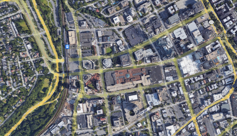

These are both edge cities featuring a train station, big buildings, and wide roads. But in Metrotown, the big buildings are next to the train station, and the flat-looking building to its north is the third-largest shopping mall in Canada. The parking goes behind the buildings, with some lots adjoining Kingsway, which has a frequent trolleybus (line 19) but is secondary as a transportation artery to SkyTrain. Farther away, the residential density remains high, with many high-rises in the typical thin-and-tall style of Vancouver. In contrast, in White Plains, one side of the station is a freeway with low-density residential development behind it, and the other is parking garages with office buildings behind them instead of the reverse.
The work required to fix this situation is not extensive. Parking must be removed and replaced with tall buildings, which can be commercial or residential depending on demand. This can be done as part of a transit-first strategy at the municipal level, but can also be compelled top-down if the city objects, since the MTA (and other Northeastern state agencies) has preemption power over local zoning on land it owns, including parking lots and garages.
On the transit side, the usual reforms for improvements in suburban trains and buses would automatically make this viable: high local frequency, integrated bus-rail timetables (to replace the lost parking), integrated fares, etc. The primary target for such reforms is completely different – it’s urban and inner-suburban rail riders – but the beauty of the S-Bahn or RER concept is that it scales well for extending the same high quality of service to the suburbs.
Schedule Planners as a Resource
The Effective Transit Alliance published its statement on Riders Alliance’s Six-Minute Service campaign, which proposes to run every subway line in New York and the top 100 bus routes every (at worst) six minutes every day from morning to evening. We’re positive on it, even more than Riders Alliance is. We go over how frequency benefits riders, as I wrote here and here, but also over how it makes planning easier. It is the latter benefit I want to go over right now: schedule planning staff is a resource, just as drivers and outside capital are, and it’s important for transit agencies to institute systems that conserve this resource and avoid creating unnecessary work for planners.
The current situation in New York
Uday Schultz writes about how schedule planning is done in New York. There’s an operations planning department, with 350 budgeted positions as of 2021 of which 284 are filled, down from 400 and 377 respectively in 2016. The department is responsible for all aspects of schedule planning: base schedules but also schedules for every service change (“General Order” or GO in short).
Each numbered or lettered route is timetabled on it own. The frequency is set by a guideline coming from peak crowding: at any off-peak period, at the most crowded point of a route, passenger crowding is supposed to be 25% higher than the seated capacity of the train; at rush hour, higher standee crowding levels are tolerated, and in practice vary widely by route. This way, two subway routes that share tracks for a long stretch will typically have different frequencies, and in practice, as perceived by passengers, off-peak crowding levels vary and are usually worse than the 25% standee factor.
Moreover, because planning is done by route, two trains that share tracks will have separate schedule plans, with little regard for integration. Occasionally, as Uday points out, this leads to literally impossible schedules. More commonly, this leads to irregular gaps: for example, the E and F trains run at the same frequency, every 4 minutes peak and every 12 minutes on weekends, but on weekends they are offset by just 2 minutes from each other, so on the long stretch of the Queens Boulevard Line where they share the express tracks, passengers have a 2-minute wait followed by a 10-minute wait.
Why?
The current situation creates more work for schedule planners, in all of the following ways:
- Each route is run on its own set of frequencies.
- Routes that share tracks can have different frequencies, requiring special attention to ensure that trains do not conflict.
- Each period of day (morning peak, midday, afternoon peak, evening) is planned separately, with transitions between peak and off-peak; there are separate schedules for the weekend.
- There are extensive GOs, each requiring not just its own bespoke timetable but also a plan for ramping down service before the start of the GO and ramping it up after it ends.
This way, a department of 284 operations planners is understaffed and cuts corners, leading to irregular and often excessively long gaps between trains. In effect, managerial rules for how to plan trains have created makework for the planners, so that an objectively enormous department still has too much work to do and cannot write coherent schedules.
Creating less work for planners
Operations planners, like any other group of employees, are a resource. It’s possible to get more of this resource by spending more money, but office staff is not cheap and American public-sector hiring has problems with uncompetitive salaries. Moreover, the makework effect doesn’t dissipate if more people are hire – it’s always possible to create more work for more planners, for example by micromanaging frequency at ever more granular levels.
To conserve this resource, multiple strategies should be used:
Regular frequencies
If all trains run on the same frequency all day, there’s less work to do, freeing up staff resources toward making sure that the timetables work without any conflict. If a distinction between peak and base is required, as on the absolute busiest routes like the E and F, then the base should be the same during all off-peak periods, so that only two schedules (peak and off-peak) are required with a ramp-up and ramp-down at the transition. This is what the six-minute service program does, but it could equally be done with a more austere and worse-for-passengers schedule, such as running trains every eight minutes off-peak.
Deinterlining
Reducing the extent of reverse-branching would enable planning more parts of the system separately from one another without so much conflict. Note that deinterlining for the purposes of good passenger service has somewhat different priorities from deinterlining for the purposes of coherent planning. I wrote about the former here and here. For the latter, it’s most important to reduce the number of connected components in the track-sharing graph, which means breaking apart the system inherited from the BMT from that inherited from the IND.
The two goals share a priority in fixing DeKalb Avenue, so that in both Manhattan and Brooklyn, the B and D share tracks as do the N and Q (today, in Brooklyn, the B shares track with the Q whereas the D shares track with the N): DeKalb Junction is a timetabling mess and trains have to wait two minutes there for a slot. Conversely, the main benefit of reverse-branching, one-seat rides to more places, is reduced since the two Manhattan trunks so fed, on Sixth Avenue and Broadway, are close to each other.
However, to enable more convenient planning, the next goal for deinterlining must be to stop using 11th Street Connection in regular service, which today transitions the R from the BMT Broadway Line and 60th Street Tunnel to the IND Queens Boulevard local tracks. Instead, the R should go where Broadway local trains go, that is Astoria, while the Broadway express N should go to Second Avenue Subway to increase service there. The vacated local service on Queens Boulevard should go to IND trunks in Manhattan, to Eighth or Sixth Avenue depending on what’s available based on changes to the rest of the system; currently, Eighth Avenue is where there is space. Optionally, no new route should be added, and instead local service on Queens Boulevard could run as a single service (currently the M) every 4 minutes all day, to match peak E and F frequencies.
GO reform
New York uses too many GOs, messing up weekend service. This is ostensibly for maintenance and worker safety, but maintenance work gets done elsewhere with fewer changes (as in Paris or Berlin) or almost none (as in Tokyo) – and Berlin and Tokyo barely have nighttime windows for maintenance, Tokyo’s nighttime outages lasting at most 3-4 hours and Berlin’s available only five nights a week. The system should push back against ever more creative service disruptions for work and demand higher maintenance productivity.
Midwestern Urban Geography and High-Speed Rail
I’ve been uploading videos about high-speed rail lately, of which the most recent, from a week ago, is a return to my attempt at producing a high-speed rail map proposal for the eastern half of the United States. I streamed and then blogged a map here with followup here, but having looked at the model more, I’d like to do a refinement – both to introduce a slightly bigger map and explain why it is so, and talk about the issue of connecting low-speed lines. Along the way, I feel like I must talk about an issue mentioned in comments occasionally about the politics of only connecting major metropolitan areas, especially since this map still has fewer lines than various state wishlists stapled by Amtrak; this is especially important because one of the motivations for this post is a criticism of current plans by Matt Yglesias.
The map
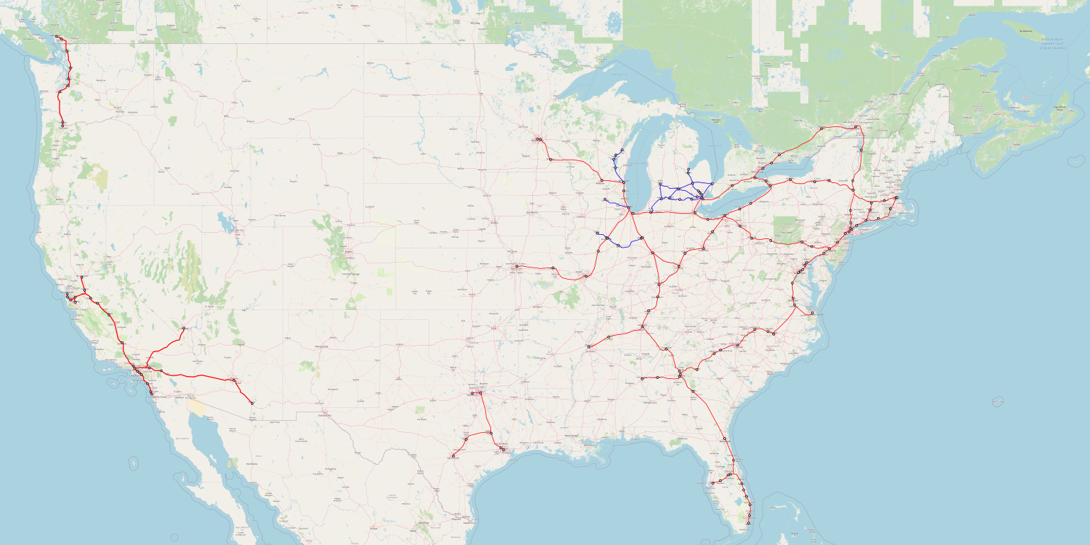
A full-size (6 MB) version of the map can be found here. This is not intended as a comprehensive map of all desirable low-speed connections – I made no effort to include the Northeastern ones, which I wrote about in the context of New England and Upstate New York, and which Ben She has done good work on in the context of eastern Pennsylvania and the mid-Atlantic. Rather, I want to focus on the Midwest.
But first, to explain a little more about why this map includes more red (high-speed) lines than previously, the reason has to do with my spreadsheet for computing ridership density based on Metcalfe’s law. The original posts computed everything by hand, which meant that some low-ridership city pairs I just rounded to zero; the spreadsheet does include them, making every line look much stronger. This, in particular, makes St. Louis-Kansas City and Atlanta-Birmingham, omitted last year, and Nashville-Memphis, suggested last year as a maybe, solid propositions.
A note of caution is still advised. Those weak city pairs that aggregate to sufficient ridership for significant return on investment are often at long distance, such as Kansas City-New York. The ridership model is trained on Shinkansen data out of Tokyo and sanity-checked with some French, German, and Spanish data, but the same model overpredicts Shinkansen ridership on inter-island trips for which planes are a convenient alternative, like Tokyo-Fukuoka or Tokyo-Hakodate. This makes me reluctant to add a Kansas City-Dallas connection, which the spreadsheet thinks generates a bit more than $1 million in annual operating profit per km of new construction: the extra ridership out of Kansas City-Dallas includes some very long-distance trips like Dallas-Detroit, for which the model is likely an overprediction.
The truth is likely between the spreadsheet and the handmade version of the model; while the Shinkansen is not competitive with planes when trains take five hours, European high-speed trains are, for example Paris-Nice. This leads to the inclusion of the new sections, but the exclusion of Kansas City-Dallas. Note also that I did look at Birmingham-New Orleans and Memphis-Little Rock, and both were weak even in the spreadsheet (though I did not attempt Birmingham-New Orleans-Houston) – the Deep South is too low-density and rural to support as expansive a system.
But the topic of this post is not the South, but the Midwest.
Midwestern urban geography
The United States is usually a country of fewer, bigger metropolitan areas, like rich Asia and unlike Europe; unlike both Europe and Asia, American cities are very decentralized, and the exceptions are in the Northeast and West, not the Midwest. In particular, naive comparisons of Midwestern to French high-speed rail corridors are unwarranted: while Chicago is of the same approximate size as Paris, and secondary Midwestern metropolitan areas like Detroit and St. Louis are substantially larger than French ones like Lyon and Marseille, Lyon and Marseille are ringed by many small metropolitan areas with their own TGV service, whereas at the same radius, St. Louis has only its suburbs.
However, this phenomenon of fewer, bigger metro areas has exceptions. Michigan, in particular, has a slightly more European geography. Using the smaller numbers produced by the metropolitan statistical area (MSA) calculation rather than the broader combined statistical area (CSA), Metro Detroit has 43% of Michigan’s population as of the 2020 census. The median Michigander lives in the Grand Rapids MSA, with 1.1 million people, fewer than the US-wide median of 1.6-1.7 million. Michigan is a fairly urban state, and below Grand Rapids is a succession of six-figure metropolitan areas: Ann Arbor, Lansing, Flint, Kalamazoo, Battle Creek, Saginaw.
Ohio is similar to Michigan. Its three main metro areas, excluding Cincinnati’s out-of-state suburbs, have just a hair less than half the state’s population; the median Buckeye therefore lives in Dayton, MSA population 800,000. Moreover, the southern half of Michigan has fairly high population density, as does Ohio – nothing as dense as the Northeast or Germany, but they’re comparable to France.
This geography lends itself to an expansive intercity rail network: the cities are relatively close to one another, and there are many of them meriting a connection. In Ohio, this happens to take the form of an entirely high-speed network, since Cleveland, Columbus, Dayton, and Cincinnati all lie on one line, and then the most natural east-west route between the Northeast and the Midwest passes through Cleveland and Toledo. Ohio, in this case, is a state with fairly good geography for low-speed intercity rail that just happens to also have good geography for high-speed rail due to its location. Michigan, in contrast, is not on the way between much, and thus should get a low-speed rail network, including both connections to Chicago (such as to Grand Rapids) and an intra-state network.
Wisconsin has many, smaller cities as well: the median resident is in an MSA of around 200,000 people, currently Racine. Fortunately, many of those cities lie on just one line between Chicago and Minneapolis, plus a low-speed branch up to Green Bay. Unfortunately, coverage is lacking by the standards of Ohio, Michigan, or much more big city-dominated Illinois and Minnesota.
Getting low-speed rail right
I am happy to report that in Michigan and Ohio at least, good projects for low-speed rail are pursued. When I streamed my video, I was told in Twitch chat that Michigan is looking into funding a Detroit-Lansing-Grand Rapids intercity train. Ohio likewise has long had ideas for a statewide network, beginning with the Cleveland-Cincinnati spine.
It is unfortunate that these projects are not planned well. In a future post, I should write more about the concept of the wrong project versus the right project done poorly; I obliquely pointed this out when writing about leakage in the context of urban transit, where some American cities have poor project prioritization (such as Los Angeles) whereas others choose more or less the right projects but execute them poorly (such as New York and San Francisco). In this schema, the current plans for low-speed rail are often the right project, done wrong.
What I mean by this is that there’s a set of best industry practices for getting low-speed (that is, legacy) rail right, emanating out of Germany and surrounding countries, especially Switzerland. These include,
- Integration of timetable planning and infrastructure, to minimize construction costs – if higher costs are acceptable, just build high-speed rail.
- A clockface all-day schedule with a minimum of one train every two hours, and ideally a train every hour if the distances are shorter or the cities are bigger.
- Timed connections at major nodes to both other intercity trains within the same network and regional mass transit (such as regional trains or connecting buses).
- Reliability-centric planning, in which sources of delays are to be proactively eliminated – on a system this tightly coordinated, delays on one line propagate across the entire system.
- An average speed of around 100-130 km/h – the higher numbers are more appropriate in flat terrain.
Marco Chitti has an excellent post that I must revisit in the future giving more detailed guidelines, mostly at regional level but also with an eye toward national intercity rail planning.
The upshot is that trying to incrementally build up ridership for a few trains per day does not work. The US has a few trains per day on a few corridors now, such as Chicago-Detroit, and daily trains on most others, and this hasn’t built up ridership. The low-speed, low-frequency intercity trains Europe had before the introduction of the TGV in France and the high-frequency, tightly-linked InterCity network in Germany were rapidly losing market share to cars and planes. To build such a network now would be like to build infrastructures wired telephones in a developing country rather than just skipping straight to cellphones as developing countries have.
Politics and Matt Yglesias’s post
Matt likes pointing out that current transportation plans in the United States are deficient, and to link to my posts as a better alternative. There was a lot of dunking on Matt’s post about this (as there is on anything that Matt writes) by left-identified people who, in effect, think daily or twice-daily trains between small cities are a great investment. This dunking usually takes the form of “how dare Matt, a lifelong East Coaster, tell people in [insert Midwestern town] that they don’t deserve trains?”. In a less abrasive form, some people in comments here, like Pharisee, have made the point that these expansive maps proposing daily trains to many places have good geographic coverage whereas what I propose does not. Let me explain why this line of thinking is wrong.
The issue is that the United States is, again, a country that for the most part has fewer, larger metropolitan areas than Europe. The map I made above hits MSAs with a large majority of the country’s population. Of the top 50 as of the 2020 census, the only misses are Denver, Oklahoma City, Salt Lake City, and New Orleans. Denver and Salt Lake City are far from everything else, and the other two are in theory on routes from Texas to the rest of the country but there’s too little population on the way for a connection in the geography of 2022.
Moreover, within the Midwest, coverage is ample. The Midwest is a highly (sub-)urbanized region, much of which has fairly high population density, and the biggest exception to the high density, Minnesota, has a large enough city to justify a line to Chicago by itself (and Milwaukee is on the way, too). The areas that are usually most moralized as Real America – Michigan, Ohio, Pennsylvania – are on the way. This shouldn’t be too surprising: the Real America moralization centers areas with a past industrial history, evoking feelings of nostalgia for midcentury American industrial dominance, and those areas remain major cities today, just relatively poorer than they were in the 1960s. This way, in the Midwest, every state has a large majority of its population in an MSA with a high- or low-speed train station on my map, except Iowa, which is unusually rural.
This is not even out of any consciously political desire to serve these areas. I draw maps out of a ridership model. It just so happens that metropolitan areas of 4 million people situated in dense geographies scream “build high-speed trains to me,” and those include Detroit.
The problem – the reason Matt is so negative on current plans – is that current plans are bad. They are low- and not high-speed rail, which by itself is not horrible, but they’re also bad low-speed rail. Daily trains are just not good. But this does not mean the Midwest can’t or shouldn’t get a good intercity rail network: it should, combining high- and low-speed trains as appropriate.
TransitCenter’s Commuter Rail Proposal
Last week, TransitCenter released a proposal for how to use commuter rail more effectively within New York. The centerpiece of the proposal is to modify service so that the LIRR and Metro-North can run more frequently to stations within the city, where today they serve the suburbs almost exclusively; at the few places near the outer end of the city where they run near the subway, they have far less ridership, often by a full order of magnitude, which pattern repeats itself around North America. There is much to like about what the proposal centers; unfortunately, it falls short by proposing half-hourly frequencies, which, while better than current off-peak service, are far short of what is needed within the city.
Commuter rail and urban ridership
TransitCenter’s proposal centers urban riders. This is a welcome addition to city discourse on commuter rail improvement. The highest-ridership, highest-traffic form of mainline rail is the fundamentally urban S-Bahn or RER concept. Truly regional trains, connecting distinct centers, coexist with them but always get a fraction of the traffic, because public transit ridership is driven by riders in dense urban and inner-suburban neighborhoods.
A lot of transit and environmental activists are uncomfortable with the idea of urban service. I can’t tell why, but too many proposals by people who should know better keep centering the suburbs. But in reality, any improvement in commuter rail service that does not explicitly forgo good practices in order to discourage urban ridership creates new urban ridership more than anything else. There just aren’t enough people in the suburbs who work in the city (even in the entire city, not just city center) for it to be any other way.
TransitCenter gets it. The proposal doesn’t even talk about inner-suburban anchors of local lines just outside the city, like Yonkers, New Rochelle, and Hempstead (and a future update of this program perhaps should). No: it focuses on the people near LIRR and Metro-North stations within the city, highlighting how they face the choice between paying extra for infrequent but fast trains to Midtown and riding very slow buses to the edge of the subway system. As these neighborhoods are for the most part on the spectrum from poor to lower middle-class, nearly everyone chooses the slow option, and ridership at the city stations is weak, except in higher-income Northeast Queens near the Port Washington Branch (see 2012-4 data here, PDF-pp. 183-207), and even there, Flushing has very little ridership since the subway is available as an alternative.
To that effect, TransitCenter proposes gradually integrating the fares between commuter rail and urban transit. This includes fare equalization and free transfers: if a bus-subway-bus trip between the Bronx and Southern Brooklyn is covered by the $127 monthly pass then so should a shorter bus-commuter rail trip between Eastern Queens or the North Bronx and Manhattan.
Interestingly, the report also shows that regionwide, poorer people have better job access by transit than richer people, even when a fare budget is imposed that excludes commuter rail. The reason is that in New York, suburbanization is a largely middle-class phenomenon, and in the suburbs, the only jobs accessible by mass transit within an hour are in Midtown Manhattan, whereas city residents have access to a greater variety of jobs by the bus and subway system. But this does not mean that the present system is equitable – rich suburbanites have cars and can use them to get to edge city jobs such as those of White Plains and Stamford, and can access the entire transit network without the fare budget whereas poorer people do have a fare budget.
The issue of frequency
Unfortunately, TransitCenter’s proposal on frequency leaves a lot to be desired. Perhaps it’s out of incrementalism, of the same kind that shows up in its intermediate steps toward fare integration. The report suggests to increase frequency to the urban stations to a train every half an hour, which it phrases in the traditional commuter rail way of trains per day: 12 roundtrips in a six-hour midday period.
And this is where the otherwise great study loses me. Forest Hills, Kew Gardens, and Flushing are all right next to subway stations. The LIRR charges higher fares there, but these are fairly middle-class areas – richer than Rosedale in Southeast Queens on the Far Rockaway Branch, which still gets more ridership than all three. No: the problem in these inner areas is frequency, and a train every half hour just doesn’t cut it when the subway is right there and comes every 2-3 minutes at rush hour and every 4-6 off-peak.
In this case, incremental increases from hourly to half-hourly frequency don’t cut it. The in-vehicle trip is so short that a train every half hour might as well not exist, just as nobody runs subway trains every half hour (even late at night, New York runs the subway every 20 minutes). At outer-urban locations like Bayside, Wakefield, and Rosedale, the absolute worst that should be considered is a train every 15 minutes, and even that is suspect and 10 minutes is more secure. Next to the subway, the absolute minimum is a train every 10 minutes.
All three mainlines currently radiating out of Manhattan in regular service – the Harlem Line, the LIRR Main Line, and the Port Washington Branch – closely parallel very busy subway trunk lines. One of the purposes of commuter rail modernization in New York must be decongestion of the subway, moving passengers from overcrowded 4, 5, 7, E, and F trains to underfull commuter trains. The LIRR and Metro-North are considered at capacity when passengers start having to use the middle seats, corresponding to 80% of seated capacity; the subway is considered at capacity when there are so many standees they don’t meet the standard of 3 square feet per person (3.59 people/m^2).
To do this, it’s necessary to not just compete with buses, but also directly compete with the subway. This is fine: Metro-North and the LIRR can act as additional express capacity, filling trains every 5 minutes using a combination of urban ridership and additional ridership at inner suburbs. TransitCenter has an excellent proposal for how to improve service quality at the urban stations but then inexplicably doesn’t go all the way and proposes a frequency that’s too low.
The Official Brooklyn Bus Redesign is Out
The MTA just released a draft of the Brooklyn bus redesign it and its consultant had been working on. It is not good. I’m not completely sure why this is – the Queens redesign was a good deal better, and our take on it at the Effective Transit Alliance was decidedly positive. But in the case of Brooklyn, the things that worked in Queens are absent. Overall, the theme of this is stasis – the changes to the network are minor, and the frequencies are to remain insufficiently low for good service. The only good thing about this is stop consolidation, which does not require spending any money on consultants and is a straightforward fix.
This is especially frustrating to me because my first project for Marron, before the Transit Costs Project, was a redesign proposal. The proposal can be read here, with discussion in blog posts here, here, and here. The official reaction we got was chilly, but the redesign doesn’t look anything like a more politic version, just one produced at much higher consultant cost while doing very little.
The four-color scheme
The Brooklyn project retains the Queens redesign’s four-color scheme of buses, to be divided into local (green), limited (red), Select Bus Service (blue), and rush (purple). The local buses are supposed to stop every 300-400 meters, which is not the best (the optimum for Brooklyn is about 400-500) but is a good deal better than the current spacing of about 200-250. The other three kinds of buses are more express, some running on the same routes as local buses as express overlays and some running on streets without local service.
In Queens, this four-way distinction emerges from the pattern in which in neighborhoods beyond the subway’s reach, bus usage is extremely peaky toward the subway. The purpose of the rush route is to get people to the subway terminal, such as Flushing or Jamaica, with not just longer stop spacing but also long nonstop sections close to the terminal where local service exists as an overlay, imitating the local and express patterns of peaky commuter rail operations in New York. I still think it’s not a good idea and buses should run at a more uniform interstation at higher frequency. But over the long stretches of Eastern Queens, the decision is fairly close and while rush routes are not optimal, they’re not much worse than the optimum. In contrast, Brooklyn is nothing like Queens: people travel shorter distances, and long routes are often used as circumferential subway connectors with ample turnover.
Ironically, this is something the MTA and its consultants understood: the Brooklyn map is largely green, whereas that in Queens has a more even mix of all four colors. Nonetheless, some rush routes are retained and so are some limited-only routes, in a way that subtracts value: if nearly all buses in Brooklyn offer me something, I should expect it on the other buses as well, whereas the rush-only B26 on Halsey Street is different in a way that isn’t clear.
In general, the notable feature of our redesign, unlike the more common American ones, is that there is no distinction among the different routes. Some are more frequent than others, but all have very high base frequency. This is because Brooklyn has unusually isotropic travel: density decreases from the East River south- and eastward, but the subway network also thins out and these effects mostly cancel out, especially with the high density of some housing projects in Coney Island; the busiest buses include some running only within Southern Brooklyn, like the B6 and B82 circumferentials.
In contrast, small-city redesigns tend to occur in a context with a strong core network and a weak peripheral network (“coverage routes,” which exist to reassure loud communities with no transit ridership that they can get buses too), and the redesign process tends to center this distinction and invest in the stronger core network. Queens has elements that look like this, if you squint your eyes sufficiently. Brooklyn has none: the isotropic density of most of the borough ensures that splitting buses into separate classes is counterproductive.
Frequency
The frequency in the proposed system is, frankly, bad. The MTA seems to believe that the appropriate frequency for urban mass transit is a train or bus every 10 minutes. This is acceptable in the suburban neighborhoods of Berlin or the outermost parts of New York, like the Rockaways and the eastern margin of Queens. In denser areas, including all of Brooklyn, it is not acceptable. People travel short distances: citywide, the average trip distance before corona was 3.4 km, which works out to 18 minutes at average New York bus speed (source: NTD 2019). In Brooklyn, the dense mesh of buses going between subway lines rather than to them makes the average even slightly lower. This means that very high frequency is a high priority.
So bad is the MTA’s thinking about frequency that core routes in the borough are split into local and limited variants, each running every 10 minutes off-peak, including some of the busiest corridors in the borough, like the outer circumferential B6 and B82 and the more inner-circumferential B35 on Church (split in the plan into a local B35 and an SBS B55). This is not changed from the current design, even though it’s easy to do so in the context of general consolidation of stops.
To make this even worse, there does not appear to be any increase in service-km, judging by the plan’s lack of net increase in frequency. This is bad planning: bus operating costs come from time (driver’s wage, mainly) and not distance, and the speedup provided by the stop consolidation should fuel an increase in frequency.
The Battery Tunnel
The most annoying aspect, at least to me, is the lack of a bus in the Brooklyn-Battery Tunnel, connecting Manhattan with Red Hook. Red Hook is isolated from the subway and from the rest of Brooklyn thanks to the freeway, and has bus connections only internally to Brooklyn where in fact a short bus route through the tunnel would beat bus-subway connections to Lower Manhattan.
We got the idea for the inclusion of such a bus service from planners that we spoke to when we wrote our own redesign. The service is cheap to provide because of the short length of the route, and would complement the rest of the network. It was also popular in the neighborhood meetings that tee consultants ran, we are told. And yet, it was deleted on a whim.
Stop Imitating the High Line
I streamed a longer version of this on Twitch on Tuesday, but the recording cut out, so instead of uploading to YouTube as a vlog, I’m summarizing it here
Manhattan has an attractive, amply-used park in the Meatpacking District, called the High Line. Here it is, just west of 10th Avenue:

It was originally a freight rail branch of the New York Central, running down the West Side of Manhattan to complement the railroad’s main line to Grand Central, currently the Harlem Line of Metro-North. As such, it was a narrow el with little direct interface with the neighborhood, unlike the rapid transit els like that on Ninth Avenue. The freight line was not useful for long: the twin inventions of trucking and electrification led to the deurbanization of manufacturing to land-intensive, single-story big box-style structures. Thus, for decades, it lay unused. As late as 2007, railfans were dreaming about reactivating it for passenger rail use, but it was already being converted to a park, opening in 2009. The High Line park is a successful addition to the neighborhood, and has spawned poor attempt at imitation, like the Low Line (an underground rapid transit terminal since bypassed by the subway), the Queensway (a similar disused line in Central Queens), and some plans in Jersey City. So what makes the High Line so good?
- The neighborhood, as can be seen above in the picture, has little park space. The tower-in-a-park housing visible to the east of the High Line, Chelsea-Elliott Houses, has some greenery but it’s not useful as a neighborhood park. The little greenery to the west is on the wrong side of 12th Avenue, a remnant of the West Side Highway that is not safe for pedestrians to cross, car traffic is so fast and heavy. Thus, it provides a service that the neighborhood previously did not have.
- The area has very high density, both residential and commercial. Chelsea is a dense residential neighborhood, but at both ends of the line there is extensive commercial development. Off-screen just to the south, bounded by Eighth, Ninth, 15th, and 16th, is Google’s building in New York, with more floor area than the Empire State Building and almost as much as One World Trade Center. Off-screen just to the north is the Hudson Yards development, which was conceived simultaneously with the High Line. This guarantees extensive foot traffic through the park.
- The linear park is embedded in a transit-rich street grid. Getting on at one end and off at the other is not much of a detour to the pedestrian tourist, or to anyone with access to the subway near both ends, making it a convenient urban trail.
These three conditions are not common, and trying to replicate the same linear park in their absence is unlikely to produce good results. For example, consider the Rockaway Cutoff, or Rockaway Beach Branch:
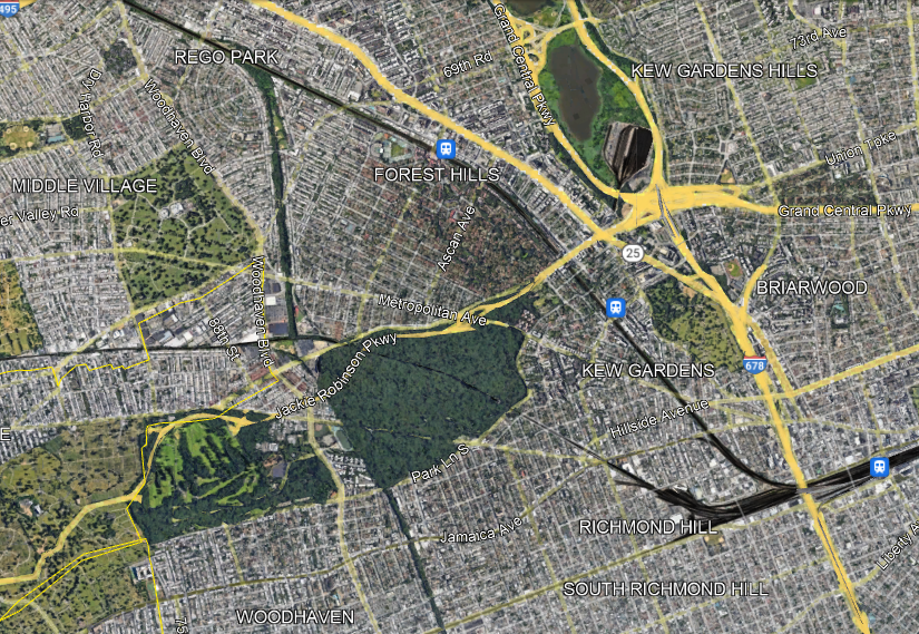
The Cutoff has two competing proposals for what to do with this disused LIRR branch: the Queenslink, aiming to convert it to a rapid transit branch (connecting to the subway, not the LIRR), and the Queensway, aiming to convert it to a linear park. The Queenslink proposal is somewhat awkward (which doesn’t mean it’s bad), but the Queensway one is completely drunk. Look at the satellite photo above and compare to that of the High Line:
- The area is full of greenery and recreation already, easily accessible from adjoining areas. Moreover, many residents live in houses with backyards.
- The density is moderate at the ends (Forest Hills and Woodhaven) and fairly low in between, with all these parks, cemeteries, and neighborhoods of single-family houses and missing middle density. Thus, local usage is unlikely to be high. Nor is this area anyone’s destination – there are some jobs at the northern margin of the area along Queens Boulevard (the wide road signed as Route 25 just north of the LIRR) but even then the main job concentrations in Queens are elsewhere.
- There is no real reason someone should use this as a hiking trail unless they want to hike it twice, one way and then back. The nearest viable parallel transit route, Woodhaven, is a bus rather than a subway.
The idea of a park is always enticing to local neighborhood NIMBYs. It’s land use that only they get to have, designed to be useless to outsiders; it is also at most marginally useful to neighborhood residents, but neighborhood politics is petty and centers exclusion of others rather than the actual benefits to residents, most of whom either don’t know their self-appointed neighborhood advocates or quietly loathe them and think of them as Karens and Beckies. Moreover, the neighborhood residents don’t pay for this – it’s a city project, a great opportunity to hog at the trough of other people’s money. Not for nothing, the Queensway website talks about how this is a community-supported solution, a good indication that it is a total waste of money.
But in reality, this is not going to be a useful park. The first park in a neighborhood is nice. The second can be, too. The fifth is just fallow land that should be used for something more productive, which can be housing, retail, or in this case a transportation artery for other people (since there aren’t enough people within walking distance of a trail to justify purely local use). The city should push back against neighborhood boosters who think that what worked in the Manhattan core will work in their explicitly anti-Manhattan areas, and preserve the right-of-way for future subway or commuter rail expansion.
It’s Easy to Waste Money
As we’re finalizing edits on our New York and synthesis reports, I’m rereading about Second Avenue Subway. In context, I’m stricken by how easy it is to waste money – to turn what should be a $600 million project into a $6 billion one or what should be a $3 billion project into a $30 billion one. Fortunately, it is also not too hard to keep costs under control if everyone involved with the project is in on the program and interested in value engineering. Unfortunately, once promises are made that require a higher budget figure, getting back in line looks difficult, because one then needs to say “no” to a lot of people.
This combination – it’s easy to stay on track, it’s easy to fall aside, it’s hard to get back on track once one falls aside – also helps explain some standard results in the literature about costs. There’s much deeper academic literature about cost overruns than absolute costs; the best-known reference is the body of work of Bent Flyvbjerg about cost overruns (which in his view are not overruns but underestimations – i.e. the real cost was high all along and the planners just lied to get the approval), but the work of Bert van Wee and Chantal Cantarelli on early commitment as a cause of overruns is critical to this as well. In van Wee and Cantarelli, once an extravagant promise is made, such a 300 km/h top speed on Dutch high-speed rail, it’s hard to walk it back even if it turns out to be of limited value compared with its cost. But equally, there are examples of promises made that have no value at all, or sometimes even negative value to the system, and are retained because of their values to specific non-state actors, such as community advocacy, which are incorrectly treated as stakeholders rather than obstacles to be removed.
In our New York report, we include a flashy example of $20 million in waste on the project: the waste rock storage chamber. The issue is that tunnel-boring machines (TBMs) in principle work 24/7; in practice they constantly break down (40% uptime is considered good) and require additional maintenance, but this can’t be predicted in advance or turned into a regular cycle of overnight shutdowns, and therefore, work must be done around the clock either way. This means that the waste rock has to be hauled out around the clock. The agency made a decision to be a good neighbor and not truck out the muck overnight – but because the TBM had to keep operating overnight, the contractor was required to build an overnight storage chamber and haul it all away with a platoon of trucks in the morning rush hour. The extra cost of the chamber and of rush hour trucking was $20 million.
Another $11 million is surplus extraction at a single park, the Marx Brothers Playground. As is common for subway projects around the world, the New York MTA used neighborhood parks to stage station entrances where appropriate. Normally, this is free. However, the New York City Department of Parks and Recreation viewed this as a great opportunity to get other people’s money; the MTA had to pay NYC Parks $11 million to use one section of the playground, which the latter agency viewed as a great success in getting money. Neither agency viewed the process as contentious; it just cost money.
But both of these examples are eclipsed by the choice of construction method for the stations. Again in order to be a good neighbor, the MTA decided to mine two of the project’s three stations, instead of opening up Second Avenue to build cut-and-cover digs. Mined stations cost extra, according to people we’ve spoken to at a number of agencies; in New York, the best benchmark is that these two stations cost the same as cut-and-cover 96th Street, a nearly 50% longer dig.
Moreover, the stations were built oversize, for reasons that largely come from planner laziness. The operating side of the subway, New York City Transit, demanded extravagant back-of-the-house function spaces, with each team having its own rooms, rather than the shared rooms typical of older stations or of subway digs in more frugal countries. The spaces were then placed to the front and back of the platform, enlarging the digs; the more conventional place for such spaces is above the platform, where there is room between the deep construction level and the street. Finally, the larger of the two station, 72nd Street, also has crossovers on both sides, enlarging the dig even further; these crossovers were included based on older operating plans, but subsequent updates made them no longer useful, and yet they were not descoped. Each station cost around $700 million, which could have been shrunk by a factor of three, keeping everything else constant.
Why are they like this?
They do not care. If someone says, “Give me an extra,” they do not say, “no.” It’s so easy not to care when it’s a project whose value is so obvious to the public; even with all this cost, the cost per rider for Second Avenue Subway is pretty reasonable. But soon enough, norms emerge in which the appearance of neighborhood impact must always be avoided (but the mined digs still cause comparable disruption at the major streets), the stations must be very large (but passengers still don’t get any roomy spaces), etc. Projects that have less value lose cost-effectiveness, and yet there is no way within the agency to improve them.
Who Through-Running is For
Shaul Picker is working on an FAQ for the benefit of people in the New York area about the concept of commuter rail through-running and what it’s good for. So in addition to contributing on some specific points, I’d like to step back for a moment and go over who the expected users are. This post needs to be thought of as a followup from what I wrote a month ago in which I listed the various travel markets used by modern commuter rail in general, making the point that this is a predominantly urban and inner-suburban mode, in which suburban rush hour commuters to city center are an important but secondary group, even where politically commuter rail is conceived of as For the Suburbs in opposition to the city, as in Munich. My post was about all-day frequency, but the same point can be made about the physical infrastructure for through-running, with some modifications.
The overall travel markets for regional rail
The assumption throughout is that the city region has with a strong center. This can come from a few square kilometers of city center skyscrapers, as is the norm in the United States (for example, in New York, Chicago, or Boston, but not weaker-centered Los Angeles), or from a somewhat wider region with office mid-rises, as is the norm in European cities like Paris, Stockholm, Munich, Zurich, and Berlin. Berlin is polycentric in the sense of having different job centers, including Mitte, City-West at the Zoo, and increasingly Friedrichshain at Warschauer Strasse, but these are all within the Ring, and overall this inner zone dominates citywide destinations. In cities like this, the main travel markets for commuter rail are, in roughly descending order of importance,
- Urban commuter trips to city center
- Commuter trips to a near-center destination, which may not be right at the one train station of traditional operations
- Urban non-work trips, of the same kind as subway ridership
- Middle-class suburban commutes to city center at traditional mid-20th century work hours, the only market the American commuter rail model serves today
- Working-class reverse-commutes, not to any visible office site (which would tilt middle-class) but to diffuse retail, care, and service work
- Suburban work and non-work trips to city center that are not at traditional mid-20th century hours
- Middle-class reverse-commutes and cross-city commutes
I center urban commuter trips because even in places with extensive suburbanization, commutes are more urban than suburban. Long Island, an unusually job-poor, commuter-oriented suburb, has 2.9 million people as of the 2020 census and, per OnTheMap, 191,202 Manhattan-bound commuters and 193,536 outer borough-bound commuters. Queens has 2.4 million people, 871,253 in-city commuters, 384,223 Manhattan-bound commuters, and 178,062 commuters to boroughs other than itself and Manhattan. The Metro-North suburbs – Westchester, Putnam, Dutchess, and Fairfield Counties (New Haven omitted as it’s not really a suburb) – have 2.35 million people and 143,862 Manhattan-bound commuters and 79,821 outer borough-bound commuters. To work regionwide, commuter rail needs to be usable by the largest commute market; it’s urban rail that’s capable of also serving the suburbs without building suburban metro tunnels, rather than predominantly suburban rail.
Through-running
Through-running means that trains run from one side of the region to the other through city center, rather than terminating at a traditional city terminal. Rarely, this means running trains through a city center station that already has through-tracks, like Penn Station or Stockholm Central; usually, this requires building new tunnels to connect different terminals, as it would to get to Grand Central and as it did in the other European comparison cases.
This rearranges the travel markets for commuter rail, but only somewhat. The largest group, urban commuters to city center, shrinks somewhat: terminating trains to some extent already serve it. The qualifiers come from the fact that city center is rarely entirely within walking distance of the terminal; it is in Stockholm, but it’s small and I suspect the reason Stockholm’s monocentric CBD is walking distance from the intercity station is that it opened as a through-station in 1871 already. In Boston, most of the CBD is close to South Station, but much of it isn’t, and little is within walking distance of North Station. In New York, the CBD is large enough that service to multiple destinations is desirable when feasible, for example both East Side and West Side destinations in Midtown and even Lower Manhattan, requiring additional through-running commuter rail tunnels.
What really shines with through-running is urban trips that are not commutes, or are commutes to a near-center destination on the wrong side of the CBD (for example, south of it for commuters from Uptown Manhattan or the Bronx). New York is unusually asymmetric in that there’s much more city east of Manhattan than west of it, where there’s just the urban parts of Hudson County and Newark. But even there, New Jersey-Brooklyn and New Jersey-Queens commutes matter, as do Bronx-Brooklyn commutes.

Even then, the urban commutes are significant: there are 55,000 commuters from the Bronx to Manhattan south of 23rd Street. These in-city travel markets are viable by subway today, but are for the most part slow even on the express trains – the A train’s run from Inwood to Jay Street and the 4’s run from Woodlawn to Brooklyn Bridge are both scheduled to take 45 minutes for 22.5 km, an average speed of 30 km/h. And then the New Jersey-to-outer borough commutes are largely unviable by public transportation – they cost double because there’s no fare integration between PATH and the subway and the transfers are onerous and slow, and besides, PATH’s coverage of the urban parts of North Jersey leaves a lot to be desired.
Adapting the city
Berlin is in a way the most S-Bahn-oriented city I know of. It’s polycentric but all centers are within the Ring and close to either the Stadtbahn or (for Potsdamer Platz) the North-South Tunnel. This shouldn’t be surprising – the Stadtbahn has been running since the 1880s, giving the city time to adapt to it, through multiple regime changes, division, and reunification. Even Paris doesn’t quite compare – the RER’s center, Les Halles, is a retail but not job center, and the five-line system only has two CBD stops, the RER A’s Auber and the RER E’s Haussmann-Saint-Lazare.
Can New York become more like Berlin if it builds through-running? The answer is yes. Midtown would remain dominant, and overall the region would become less rather than more polycentric as better commuter rail service encouraged job growth in the Manhattan core. But it’s likely any of the following changes would grow the market for commuter rail to take advantage of through-running over time:
- Job growth in Lower Manhattan, which has struggled with office vacancy for decades
- Job growth in non-CBD parts of Manhattan that would become accessible, like Union Square, or even Midtown South around Penn Station, which is lower-rise than the 40s and 50s
- Job growth in near-center job centers – Downtown Brooklyn may see a revival, and Long Island City is likely to see a larger upswing than it is already seeing if it becomes more accessible from New Jersey and not just the city
- Residential location adjustment – Brooklyn workers may choose to depend on the system and live in the Bronx or parts of New Jersey with good service instead of moving farther out within Brooklyn or suburbanizing and driving to work
- Residential transit-oriented development near outlying stations, in urban as well as suburban areas
Berlin Greens Know the Price of Everything and Value of Nothing
While trying to hunt down some numbers on the costs of the three new U5 stations, I found media discourse in Berlin about the U-Bahn expansion plan that was, in effect, greenwashing austerity. This is related to the general hostility of German urbanists and much of the Green Party (including the Berlin branch) to infrastructure at any scale larger than that of a bike lane. But the specific mechanism they use – trying to estimate the carbon budget – is a generally interesting case of knowing the costs more certainly than the benefits, which leads to austerity. The underlying issue is that mode shift is hard to estimate accurately at the level of the single piece of infrastructure, and therefore benefit-cost analyses that downplay ridership as a benefit and only look at mode shift lead to underbuilding of public transport infrastructure.
The current program in Berlin
In the last generation, Berlin has barely expanded its rapid transit network. The priority in the 1990s was to restore sections that had been cut by the Berlin Wall, such as the Ringbahn, which was finally restored with circular service in 2006. U-Bahn expansion, not including restoration of pre-Wall services, included two extensions of U8, one north to Wittenau that had begun in the 1980s and a one-stop southward extension of U8 to Hermannstrasse, which project had begun in the 1920s but been halted during the Depression. Since then, the only fully new extension have been a one-stop extension of U2 to Pankow, and the six-stop extension of U5 west from Alexanderplatz to Hauptbahnhof.
However, plans for much more expansive construction continue. Berlin was one of the world’s largest and richest cities before the war, and had big plans for further growth, which were not realized due to the war and division; in that sense, I believe it is globally only second to New York in the size of its historic unrealized expansion program. The city will never regain its relative wealth or size, not in a world of multiple hypercities, but it is growing, and as a result, it’s dusting off some of these plans.
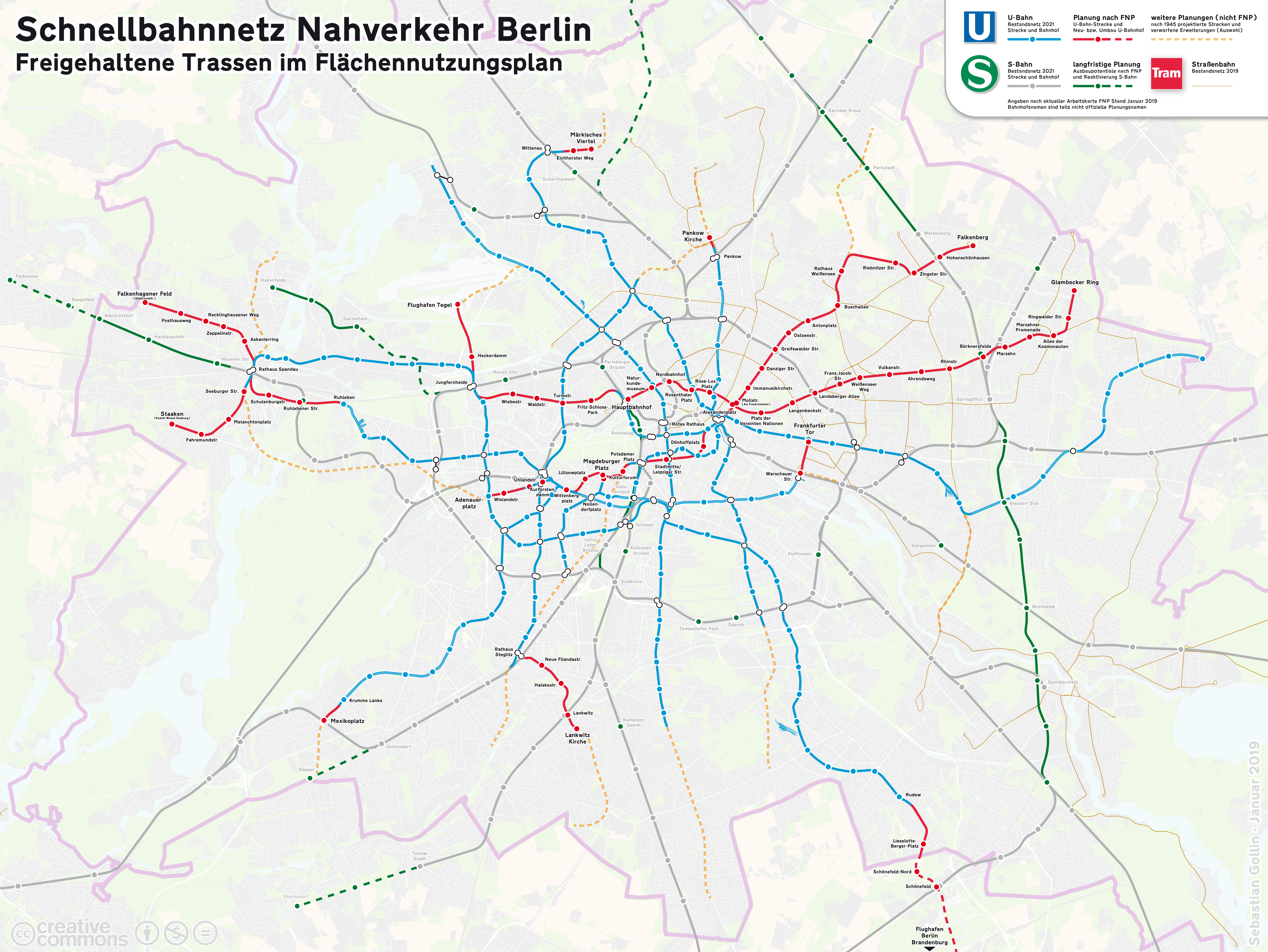
Most of the lines depicted in red on the map are not at all on the city’s list of projects to be built by the 2030s. Unfortunately, the most important line measured by projected cost per rider, the two-stop extension of U8 north (due east) to Märkisches Viertel, is constantly deprioritized. The likeliest lines to be built per current politicking are the extensions of U7 in both directions, southeast ti the airport (beyond the edge of the map) and west from Spandau to Staaken, and the one-stop extension of U3 southwest to Mexikoplatz to connect with the S-Bahn. An extension to the former grounds of Tegel is also considered, most likely a U6 branch depicted as a lower-priority dashed yellow line on the map rather than the U5 extension the map depicts in red.
The carbon critique
Two days after the U5 extension opened two years ago, a report dropped that accused the proposed program of climate catastrophe. The argument: the embedded concrete emissions of subway construction are high, and the payback time on those from mode shift is more than 100 years.
The numbers in the study are, as follows: each kilometer of construction emits 98,800 tons of CO2, which is 0.5% of city emissions (that is, 5.38 t/person, cf. the German average of about 9.15 in 2021). It’s expected that through mode shift, each subway kilometer saves 714 t-CO2 in annual emissions through mode shift, which is assumed to be 20% of ridership, for a payback time of 139 years.
And this argument is, frankly, garbage. The scale of the difference in emissions between cities with and without extensive subway systems is too large for this to be possibly true. The U-Bahn is 155 km long; if the 714 t/km number holds, then in a no U-Bahn counterfactual, Berlin’s annual greenhouse gas emissions grow by 0.56%, which is just ridiculous. We know what cities with no or minimal rapid transit systems look like, and they’re not 0.56% worse than comparanda with extensive rapid transit – compare any American city to New York, for one. Or look again at the comparison of Berlin to the German average: Berlin has 327 cars per 1,000 people, whereas Germany-wide it’s 580 and that’s with extensive rapid transit systems in most major cities bringing down the average from the subway-free counterfactual of the US or even Poland.
The actual long-term effect of additional public transport ridership on mode shift and demotorization has to be much more than 20%, then. It may well be more than 100%: the population density that the transit city supports also increases the walking commute modal split as some people move near work, and even drivers drive shorter distances due to the higher density. This, again, is not hard to see at the level of sanity checks: Europeans drive considerably less than Americans not just per capita but also per car, and in the United States, people in New York State drive somewhat shorter distance per car than Americans elsewhere (I can’t find city data).
The measurement problem
It’s easy to measure the embedded concrete of infrastructure construction: there are standardized itemized numbers for each element and those can be added up. It’s much harder to measure the carbon savings from the existence of a better urban rail system. Ridership can be estimated fairly accurately, but long-term mode shift can’t. This is where rules of thumb like 20% can look truthy, even if they fail any sanity check.
But it’s not correct to take any difficult to estimate number and set it to zero. In fact, there are visible mode shift effects from a large mass transit system. The difficulty is with attributing specific shifts to specific capital investments. Much of the effect of mode shift comes from the ability of an urban rail system to contribute to the rise of a strong city center, which can be high-rise (as in New York), mid-rise (as in Munich or Paris), or a mix (as in Berlin). Once the city center anchored by the system exists, jobs are less likely to suburbanize to auto-oriented office parks, and people are likelier to work in city center and take the train. Social events will likewise tend to pick central locations to be convenient for everyone, and denser neighborhoods make it easier to walk or bike to such events, and this way, car-free travel is possible even for non-work trips.
This, again, can be readily verified by looking at car ownership rates, modal splits (for example, here is Berlin’s), transit-oriented development, and so on, but it’s difficult to causally attribute it to a specific piece of infrastructure. Nonetheless, ignoring this effect is irresponsible: it means the carbon benefit-cost analysis, and perhaps the economic case as well, knows the cost of everything and the value of little, which makes investment look worse than it is.
I suspect that this is what’s behind the low willingness to invest in urban rail here. The benefit-cost analyses can leave too much value on the table, contributing to public transport austerity. When writing the Sweden report, I was stricken by how the benefit-cost analyses for both Citybanan and Nya Tunnelbanan were negative, when the ridership projections were good relative to costs. Actual ridership growth on the Stockholm commuter trains from before the opening of Citybanan to 2019 was enough to bring cot per new daily trip down to about $29,000 in 2021 PPP dollars, and Nya Tunnelbanan’s daily ridership projection of 170,000 means around $23,000/rider. The original construction of the T-bana cost $2,700/rider in 2021 dollars, in a Sweden that was only about 40% as rich as it is today, and has a retrospective benefit-cost ratio of between 6 and 8.5, depending on whether broader agglomeration benefit are included – and these benefits are economic (for example, time savings, or economic productivity from agglomeration) scale linearly with income.
At least Sweden did agree to build both lines, recognizing the benefit-cost analysis missed some benefits. Berlin instead remains in austerity mode. The lines under discussion right now are projected between 13,160€ and 27,200€ per weekday trip (and Märkisches Viertel is, again, the cheapest). The higher end, represented by the U6 branch to Tegel, is close to the frontier of what a country as rich as Germany should build; M18 in Paris is projected to be more than this, but area public transport advocates dislike it and treat it as a giveaway to rich suburbs. And yet, the U6 branch looks unlikely to be built right now. When the cost per rider of what is left is this low, what this means is that the city needs to build more infrastructure, or else it’s leaving value on the table.
Philadelphia and High-Speed Rail Bypasses (Hoisted from Social Media)
I’d like to discuss a bypass of Philadelphia, as a followup from my previous post, about high-speed rail and passenger traffic density. To be clear, this is not a bypass on Northeast Corridor trains: every train between New York and Washington must continue to stop in Philadelphia at 30th Street Station or, if an in my opinion unadvised Center City tunnel is built, within the tunnel in Center City. Rather, this is about trains between New York and points west of Philadelphia, including Harrisburg, Pittsburgh, and the entire Midwest. Whether the bypass makes sense depends on traffic, and so it’s an example of a good investment for later, but only after more of the network is built. This has analogs in Germany as well, with a number of important cities whose train stations are terminals (Frankfurt, Leipzig) or de facto terminals (Cologne, where nearly all traffic goes east, not west).
Philadelphia and Zoo Junction
Philadelphia historically has three mainlines on the Pennsylvania Railroad, going to north to New York, south to Washington, and west to Harrisburg and Pittsburgh. The first two together form the southern half of the Northeast Corridor; the third is locally called the Main Line, as it was the PRR’s first line.

Trains can run through from New York to Washington or from Harrisburg to Washington. The triangle junction northwest of the station, Zoo Junction, permits trains from New York to run through to Harrisburg and points west, but they then have to skip Philadelphia. Historically, the fastest PRR trains did this, serving the city at North Philadelphia with a connection to the subway, but this was in the context of overnight trains of many classes. Today’s Keystone trains between New York and Harrisburg do no such thing: they go from New York to Philadelphia, reverse direction, and then go onward to Harrisburg. This is a good practice in the current situation – the Keystones run less than hourly, and skipping Philadelphia would split frequencies between New York and Philadelphia to the point of making the service much less useful.
When should trains skip Philadelphia?
The advantage of skipping Philadelphia are that trains from New York to Harrisburg (and points west) do not have to reverse direction and are therefore faster. On the margin, it’s also beneficial for passengers to face forward the entire trip (as is typical on American and Japanese intercity trains, but not European ones). The disadvantage is that it means trains from Harrisburg can serve New York or Philadelphia but not both, cutting frequency to each East Coast destination. The effect on reliability and capacity is unclear – at very high throughput, having more complex track sharing arrangements reduces reliability, but then having more express trains that do not make the same stop on the same line past New York and Newark does allow trains to be scheduled closer to each other.
The relative sizes of New York, Philadelphia, and Washington are such that traffic from Harrisburg is split fairly evenly between New York on the other hand and Philadelphia and Washington on the other hand. So this really means halving frequency to each of New York and Philadelphia; Washington gets more service with split service, since if trains keep reversing direction, there shouldn’t be direct Washington-Harrisburg trains and instead passengers should transfer at 30th Street.
The impact of frequency is really about the headway relative to the trip time. Half-hourly frequencies are unconscionable for urban rail and very convenient for long-distance intercity rail. The headway should be much less than the one-way trip time, ideally less than half the time: for reference, the average unlinked New York City Subway trip was 13 minutes in 2019, and those 10- and 12-minute off-peak frequencies were a chore – six-minute frequencies are better for this.
The current trip time is around 1:20 New York-Philadelphia and 1:50 Philadelphia-Harrisburg, and there are 14 roundtrips to Harrisburg a day, for slightly worse than hourly service. It takes 10 minutes to reverse direction at 30th Street, plus around five minutes of low-speed running in the station throat. Cutting frequency in half to a train every two hours would effectively add an hour to what is a less than a two-hour trip to Philadelphia, even net of the shorter trip time, making it less viable. It would eat into ridership to New York as well as the headway rose well above half the end-to-end trip, and much more than that for intermediate trips to points such as Trenton and Newark. Thus, the current practice of reversing direction is good and should continue, as is common at German terminals.
What about high-speed rail?
The presence of a high-speed rail network has two opposed effects on the question of Philadelphia. On the one hand, shorter end-to-end trip times make high frequencies even more important, making the case for skipping Philadelphia even weaker. In practice, high speeds also entail speeding up trains through station throats and improving operations to the point that trains can change directions much faster (in Germany it’s about four minutes), which weakens the case for skipping Philadelphia as well if the impact is reduced from 15 minutes to perhaps seven. On the other hand, heavier traffic means that the base frequency becomes much higher, so that cutting it in half is less onerous and the case for skipping Philadelphia strengthens. Already, a handful of express trains in Germany skip Leipzig on their way between Berlin and Munich, and as intercity traffic grows, it is expected that more trains will so split, with an hourly train skipping Leipzig and another serving it.
With high-speed rail, New York-Philadelphia trip times fall to about 45 minutes in the example route I drew for a post from 2020. I have not done such detailed work outside the Northeast Corridor, and am going to assume a uniform average speed of 240 km/h in the Northeast (which is common in France and Spain) and 270 km/h in the flatter Midwest (which is about the fastest in Europe and is common in China). This means trip times out of New York, including the reversal at 30th Street, are approximately as follows:
Philadelphia: 0:45
Harrisburg: 1:30
Pittsburgh: 2:40
Cleveland: 3:15
Toledo: 3:55
Detroit: 4:20
Chicago: 5:20
Out of both New York and Philadelphia, my gravity model predicts that the strongest connection among these cities is by Pittsburgh, then Cleveland, then Chicago, then Detroit, then Harrisburg. So it’s best to balance the frequency around the trip time to Pittsburgh or perhaps Cleveland. In this case, even hourly trains are not too bad, and half-hourly trains are practically show-up-and-go frequency. The model also predicts that if trains only run on the Northeast Corridor and as far as Pittsburgh then traffic fills about two hourly trains; in that case, without the weight of longer trips, the frequency impact of skipping Philadelphia and having one hourly train run to New York and Boston and another to Philadelphia and Washington is likely higher than the benefit of reducing trip times on New York-Harrisburg by about seven minutes.
In contrast, the more of the network is built out, the higher the base frequency is. With the Northeast Corridor, the spine going beyond Pittsburgh to Detroit and Chicago, a line through Upstate New York (carrying Boston-Cleveland traffic), and perhaps a line through the South from Washington to the Piedmont and beyond, traffic rises to fill about six trains per hour per the model. Skipping Philadelphia on New York-Pittsburgh trains cuts frequency from every 10 minutes to every 20 minutes, which is largely imperceptible, and adds direct service from Pittsburgh and the Midwest to Washington.
Building a longer bypass
So far, we’ve discussed using Zoo Junction. But if there’s sufficient traffic that skipping Philadelphia shouldn’t be an onerous imposition, it’s possible to speed up New York-Harrisburg trains further. There’s a freight bypass from Trenton to Paoli, roughly following I-276; a bypass using partly that right-of-way and, where it curves, that of the freeway, would require about 70 km of high-speed rail construction, for maybe $2 billion. This would cut about 15 km from the trip via 30th Street or 10 km via the Zoo Junction bypass, but the tracks in the city are slow even with extensive work. I believe this should cut another seven or eight minutes from the trip time, for a total of 15 minutes relative to stopping in Philadelphia.
I’m not going to model the benefits of this bypass. The model can spit out an answer, which is around $120 million a year in additional revenue from faster trips relative to not skipping Philadelphia, without netting out the impact of frequency, or around $60 million relative to skipping via Zoo, for a 3% financial ROI; the ROI grows if one includes more lines in the network, but by very little (the Cleveland-Cincinnati corridor adds maybe 0.5% ROI). But this figure has a large error bar and I’m not comfortable using a gravity model for second-order decisions like this.
